Use these links to rapidly review the document
TABLE OF CONTENTS
INDEX TO CONSOLIDATED FINANCIAL STATEMENTS
UNITED STATES
SECURITIES AND EXCHANGE COMMISSION
Washington, D.C. 20549
Form 10-K
(Mark One) | ||
ý |
ANNUAL REPORT PURSUANT TO SECTION 13 OR 15(d) OF THE SECURITIES EXCHANGE ACT OF 1934 |
|
For the fiscal year ended December 31, 2012 |
||
or |
||
o |
TRANSITION REPORT PURSUANT TO SECTION 13 OR 15(d) OF THE SECURITIES EXCHANGE ACT OF 1934 |
|
For the transition period from to |
||
Commission file number 1-08895 |
HCP, Inc.
(Exact name of registrant as specified in its charter)
Maryland | 33-0091377 | |
(State or other jurisdiction of incorporation or organization) |
(I.R.S. Employer Identification No.) |
|
3760 Kilroy Airport Way, Suite 300 Long Beach, California |
90806 (Zip Code) |
|
(Address of principal executive offices) | ||
Registrant's telephone number, including area code (562) 733-5100 |
||
Securities registered pursuant to Section 12(b) of the Act: |
Title of each class | Name of each exchange on which registered |
|
---|---|---|
Common Stock |
New York Stock Exchange |
Indicate by check mark if the registrant is a well-known seasoned issuer, as defined in Rule 405 of the Securities Act. Yes ý No o
Indicate by check mark if the registrant is not required to file reports pursuant to Section 13 or Section 15(d) of the Act. Yes o No ý
Indicate by check mark whether the registrant; (1) has filed all reports required to be filed by Section 13 or 15(d) of the Securities Exchange Act of 1934 during the preceding 12 months (or for such shorter period that the registrant was required to file such reports), and (2) has been subject to such filing requirements for the past 90 days. Yes ý No o
Indicate by check mark whether the registrant has submitted electronically and posted on its corporate Web site, if any, every Interactive Data File required to be submitted and posted pursuant to Rule 405 of Regulation S-T (§232.405 of this chapter) during the preceding 12 months (or for such shorter period that the registrant was required to submit and post such files). Yes ý No o
Indicate by check mark if disclosure of delinquent filers pursuant to Item 405 of Regulation S-K (§ 229.405 of this chapter) is not contained herein, and will not be contained, to the best of registrant's knowledge, in definitive proxy or information statements incorporated by reference in Part III of this Form 10-K or any amendment to this Form 10-K. ý
Indicate by check mark whether the registrant is a large accelerated filer, an accelerated filer, a non-accelerated filer, or a smaller reporting company. See the definitions of "large accelerated filer," "accelerated filer" and "smaller reporting company" in Rule 12b-2 of the Exchange Act. (check one):
Large accelerated filer ý | Accelerated filer o | Non-accelerated filer o (Do not check if a smaller reporting company) |
Smaller reporting company o |
Indicate by check mark whether the registrant is a shell company (as defined by Rule 12b-2 of the Act.) Yes o No ý
State the aggregate market value of the voting and non-voting common equity held by non-affiliates computed by reference to the price at which the common equity was last sold, or the average bid and asked price of such common equity, as of the last business day of the registrant's most recently completed second fiscal quarter: $18.8 billion.
As of February 4, 2013 there were 453,379,156 shares of common stock outstanding.
DOCUMENTS INCORPORATED BY REFERENCE
Portions of the definitive Proxy Statement for the registrant's 2013 Annual Meeting of Stockholders have been incorporated by reference into Part III of this Report.
2
All references in this report to "HCP," the "Company," "we," "us" or "our" mean HCP, Inc. together with its consolidated subsidiaries. Unless the context suggests otherwise, references to "HCP, Inc." mean the parent company without its subsidiaries.
Business Overview
HCP, an S&P 500 company, invests primarily in real estate serving the healthcare industry in the United States. We are a Maryland corporation organized in 1985 to qualify as a self-administered real estate investment trust ("REIT"). We are headquartered in Long Beach, California, with offices in Nashville, Tennessee and San Francisco, California. We acquire, develop, lease, manage and dispose of healthcare real estate, and provide financing to healthcare providers. Our portfolio is comprised of investments in the following five healthcare segments: (i) senior housing, (ii) post-acute/skilled nursing, (iii) life science, (iv) medical office and (v) hospital. We make investments within our healthcare segments using the following five investment products: (i) properties under lease, (ii) debt investments, (iii) developments and redevelopments, (iv) investment management and (v) investments in senior housing operations utilizing the structure permitted by the Housing and Economic Recovery Act of 2008, which is commonly referred to as "RIDEA."
The delivery of healthcare services requires real estate and, as a result, tenants and operators depend on real estate, in part, to maintain and grow their businesses. We believe that the healthcare real estate market provides investment opportunities due to the following:
Our website address is www.hcpi.com. Our Annual Reports on Form 10-K, Quarterly Reports on Form 10-Q, Current Reports on Form 8-K and any amendments to those reports filed or furnished pursuant to Section 13(a) or 15(d) of the Securities Exchange Act of 1934 (the "Exchange Act") are available on our website, free of charge, as soon as reasonably practicable after we electronically file such materials with, or furnish them to, the United States ("U.S.") Securities and Exchange Commission ("SEC").
Healthcare Industry
Healthcare is the single largest industry in the U.S. based on Gross Domestic Product ("GDP"). According to the National Health Expenditures report by the Centers for Medicare and Medicaid Services ("CMS"): (i) national health expenditures are projected to grow 3.8% in 2013 and 7.4% in 2014; (ii) the average compounded annual growth rate for national health expenditures, over the projection period of 2015 through 2021, is anticipated to be 6.2%; and (iii) the healthcare industry is projected to represent 17.8% of U.S. GDP in 2013.
Senior citizens are the largest consumers of healthcare services. According to CMS, on a per capita basis, the 75-year and older segment of the population spends 76% more on healthcare than the 65 to 74-year-old segment and over 200% more than the population average.
3
U.S. Population Over 65 Years Old
Source: U.S. Census Bureau, the Statistical Abstract of the United States.
Business Strategy
Our primary goal is to increase shareholder value through profitable growth, which allows us to maintain or increase dividends per share to our shareholders. Our investment strategy to achieve this goal is based on three principles: (i) opportunistic investing, (ii) portfolio diversification and (iii) conservative financing.
Opportunistic Investing
We make investment decisions that are expected to drive profitable growth and create shareholder value. We attempt to position ourselves to create and take advantage of situations to meet our goals and investment criteria.
Portfolio Diversification
We believe in maintaining a portfolio of healthcare investments diversified by segment, geography, operator, tenant and investment product. We monitor, but do not limit, our investments based on the percentage of our total assets that may be invested in any one property type, investment product, geographic location, the number of properties which we may lease to a single operator or tenant, or loans we may make to a single borrower. With investments in multiple segments and investment products, we can focus on opportunities with the most attractive risk/reward profile for the portfolio as a whole. We may structure transactions as master leases, require operator or tenant insurance and indemnifications, obtain credit enhancements in the form of guarantees, letters of credit or security deposits, and take other measures to mitigate risk.
Conservative Financing
We believe a conservative balance sheet is important to our ability to execute our opportunistic investing approach. We strive to maintain a conservative balance sheet by actively managing our debt-to-equity levels and maintaining multiple sources of liquidity, such as our revolving line of credit facility, access to capital markets and secured debt lenders, relationships with current and prospective institutional joint venture partners, and our ability to divest of assets. Our debt obligations are primarily fixed rate with staggered maturities, which reduces the impact of rising interest rates on our operations.
We finance our investments based on our evaluation of available sources of funding. For short-term purposes, we may utilize our revolving line of credit facility or arrange for other short-term borrowings from banks or other sources. We arrange for longer-term financing through offerings of
4
equity and debt securities, placement of mortgage debt and capital from other institutional lenders and equity investors.
We specifically incorporate by reference into this section the information set forth in Item 7, "2012 Transaction Overview," included elsewhere in this report.
Competition
Investing in real estate serving the healthcare industry is highly competitive. We face competition from other REITs, investment companies, pension funds, private equity and hedge fund investors, sovereign funds, healthcare operators, lenders, developers and other institutional investors, some of whom may have greater resources and lower costs of capital than we do. Increased competition makes it more challenging for us to identify and successfully capitalize on opportunities that meet our objectives. Our ability to compete may also be impacted by national and local economic trends, availability of investment alternatives, availability and cost of capital, construction and renovation costs, existing laws and regulations, new legislation and population trends.
Income from our facilities is dependent on the ability of our operators and tenants to compete with other companies on a number of different levels, including: the quality of care provided, reputation, the physical appearance of a facility, price and range of services offered, alternatives for healthcare delivery, the supply of competing properties, physicians, staff, referral sources, location, the size and demographics of the population in surrounding areas, and the financial condition of our tenants and operators. Private, federal and state payment programs as well as the effect of laws and regulations may also have a significant influence on the profitability of our tenants and operators. For a discussion of the risks associated with competitive conditions affecting our business, see "Risk Factors" in Item 1A.
Healthcare Segments
Senior housing. At December 31, 2012, we had interests in 441 senior housing facilities, 21 of which are in a RIDEA structure. Excluding RIDEA properties, all of our senior housing facilities are leased to single tenants under triple-net lease structures. Senior housing facilities include assisted living facilities ("ALFs"), independent living facilities ("ILFs") and continuing care retirement communities ("CCRCs"), which cater to different segments of the elderly population based upon their personal needs. Services provided by our operators or tenants in these facilities are primarily paid for by the residents directly or through private insurance and are less reliant on government reimbursement programs such as Medicaid and Medicare. Our senior housing property types are further described below:
5
facilities, residents have the option to contract for these services. At December 31, 2012, we had interests in 64 ILFs.
During the fourth quarter of 2012, we acquired 129 senior housing communities for $1.7 billion, from a joint venture between Emeritus Corporation and Blackstone Real Estate Partners VI, an affiliate of Blackstone (the "Blackstone JV"). Located in 29 states, the portfolio encompasses 10,077 units representing a diversified care mix of 61% assisted living, 25% independent living, 13% memory care and 1% skilled nursing. Emeritus continues to operate the communities pursuant to a new triple-net, master lease for the 129 properties guaranteed by Emeritus. For a more detailed description of the acquisition see Note 4 to the Consolidated Financial Statements.
Our senior housing segment accounted for approximately 33%, 30% and 30% of total revenues for the years ended December 31, 2012, 2011 and 2010, respectively. The following table provides information about our senior housing operator concentration for the year ended December 31, 2012:
Operators
|
Percentage of Segment Revenues |
Percentage of Total Revenues |
|||||
---|---|---|---|---|---|---|---|
HCR ManorCare, Inc. ("HCR ManorCare")(1) |
11 | 30 | |||||
Emeritus Corporation ("Emeritus")(2) |
23 | 8 | |||||
Sunrise Senior Living Inc. ("Sunrise")(3) |
15 | 5 | |||||
Brookdale Senior Living, Inc. ("Brookdale")(4) |
14 | 5 |
Post-acute/skilled nursing. At December 31, 2012, we had interests in 312 post-acute/skilled nursing facilities ("SNFs"). SNFs offer restorative, rehabilitative and custodial nursing care for people not requiring the more extensive and sophisticated treatment available at hospitals. Ancillary revenues and revenues from sub-acute care services are derived from providing services to residents beyond room and board and include occupational, physical, speech, respiratory and intravenous therapy, wound care, oncology treatment, brain injury care and orthopedic therapy as well as sales of pharmaceutical products and other services. Certain SNFs provide some of the foregoing services on an out-patient basis. Post-acute/skilled nursing services provided by our operators and tenants in these facilities are primarily paid for either by private sources or through the Medicare and Medicaid programs. All of our SNFs are leased to single tenants under triple-net lease structures.
6
Our post-acute/skilled nursing segment accounted for approximately 29%, 29% and 13% of total revenues for the years ended December 31, 2012, 2011 and 2010, respectively. The following table provides information about our post-acute/skilled nursing operator/tenant concentration for the year ended December 31, 2012:
Operators/Tenants and Borrowers
|
Percentage of Segment Revenues |
Percentage of Total Revenues |
|||||
---|---|---|---|---|---|---|---|
HCR ManorCare(1) |
90 | 30 |
Life science. At December 31, 2012, we had interests in 113 life science properties, including four facilities owned by our Investment Management Platform. These properties contain laboratory and office space primarily for biotechnology, medical device and pharmaceutical companies, scientific research institutions, government agencies and other organizations involved in the life science industry. While these properties contain similar characteristics to commercial office buildings, they generally contain more advanced electrical, mechanical, and heating, ventilating, and air conditioning ("HVAC") systems. The facilities generally have specialty equipment including emergency generators, fume hoods, lab bench tops and related amenities. In many instances, life science tenants make significant investments to improve their leased space, in addition to landlord improvements, to accommodate biology, chemistry or medical device research initiatives. Life science properties are primarily configured in business park or campus settings and include multiple buildings. The business park and campus settings allow us the opportunity to provide flexible, contiguous/adjacent expansion to accommodate the growth of existing tenants. Our properties are located in well-established geographical markets known for scientific research, including San Francisco, San Diego and Salt Lake City. At December 31, 2012, 96% of our life science leases (based on leased square feet) were under triple-net structures.
Our life science segment accounted for approximately 15%, 17% and 22% of total revenues for the years ended December 31, 2012, 2011 and 2010, respectively. The following table provides information about our life science tenant concentration for the year ended December 31, 2012:
Tenants
|
Percentage of Segment Revenues |
Percentage of Total Revenues |
|||||
---|---|---|---|---|---|---|---|
Genentech, Inc. |
19 | 3 | |||||
Amgen, Inc. |
18 | 3 |
Medical office. At December 31, 2012, we had interests in 273 medical office buildings ("MOBs"), including 66 facilities owned by our Investment Management Platform. These facilities typically contain physicians' offices and examination rooms, and may also include pharmacies, hospital ancillary service space and outpatient services such as diagnostic centers, rehabilitation clinics and day-surgery operating rooms. While these facilities are similar to commercial office buildings, they require additional plumbing, electrical and mechanical systems to accommodate multiple exam rooms that may require sinks in every room, and special equipment such as x-ray machines. In addition, MOBs are often built to accommodate higher structural loads for certain equipment and may contain "vaults" or other specialized construction. Our MOBs are typically multi-tenant properties leased to healthcare providers (hospitals and physician practices), with approximately 77% of our MOBs, based on square feet, located on hospital campuses and 94% are affiliated with hospital systems. At December 31, 2012, 47% of our medical office leases (based on leased square feet) were under triple-net structures.
7
Our medical office segment accounted for approximately 18%, 19% and 25% of total revenues for the years ended December 31, 2012, 2011 and 2010, respectively. During the year ended December 31, 2012, HCA, Inc. ("HCA"), as our tenant, contributed 14% of our medical office segment revenues.
Our Investment Management Platform represents the following unconsolidated joint ventures: (i) HCP Ventures III, LLC, and HCP Ventures IV, LLC, which consists of MOB portfolios, and (ii) the HCP Life Science ventures. For a more detailed description of these unconsolidated joint ventures, see Note 8 to the Consolidated Financial Statements.
Hospital. At December 31, 2012, we had interests in 21 hospitals, including four facilities owned by our Investment Management Platform. Services provided by our operators and tenants in these facilities are paid for by private sources, third-party payors (e.g., insurance and Health Maintenance Organizations or "HMOs"), or through the Medicare and Medicaid programs. Our hospital property types include acute care, long-term acute care, specialty and rehabilitation hospitals. Our hospitals are generally leased to single tenants or operators under triple-net lease structures.
Our hospital segment accounted for approximately 5%, 5% and 10% of total revenues for the years ended December 31, 2012, 2011 and 2010, respectively. The following table provides information about our hospital operator/tenant concentration for the year ended December 31, 2012:
Operators/Tenants and Borrowers
|
Percentage of Segment Revenues |
Percentage of Total Revenues |
|||||
---|---|---|---|---|---|---|---|
HCA(1) |
29 | 4 | |||||
Tenet Healthcare Corporation |
27 | 1 |
Investment Products
Properties under lease. We primarily generate revenue by leasing properties under long-term leases. Most of our rents and other earned income from leases are received under triple-net leases or leases that provide for a substantial recovery of operating expenses. However, some of our MOBs and life science facility rents are structured under gross or modified gross leases. Accordingly, for such gross or modified gross leases, we incur certain property operating expenses, such as real estate taxes, repairs and maintenance, property management fees, utilities and insurance.
Our ability to grow income from properties under lease depends, in part, on our ability to (i) increase rental income and other earned income from leases by increasing rental rates and occupancy levels, (ii) maximize tenant recoveries and (iii) control non-recoverable operating expenses. Most of our leases include contractual annual base rent escalation clauses that are either predetermined fixed increases and/or are a function of an inflation index.
Debt investments. Our mezzanine loans are generally secured by a pledge of ownership interests of an entity or entities, which directly or indirectly own properties, and are subordinate to more senior debt, including mortgages and more senior mezzanine loans. Borrowers of our interests in mortgage and construction loans are typically healthcare providers and healthcare real estate generally secures these loans.
Developments and redevelopments. We generally commit to development projects that are at least 50% pre-leased or when we believe that market conditions will support speculative construction. We work closely with our local real estate service providers, including brokerage, property management, project management and construction management companies to assist us in evaluating development proposals and completing developments. Our development and redevelopment investments are primarily in our life science and medical office segments. Redevelopments are properties that require
8
significant capital expenditures (generally more than 25% of acquisition cost or existing basis) to update, achieve stabilization or to change the primary use of the properties.
Investment management. We co-invest in real estate properties with institutional investors through joint ventures structured as partnerships or limited liability companies. We target institutional investors with long-term investment horizons who seek to benefit from our expertise in healthcare real estate. Predominantly, we retain noncontrolling interests in the joint ventures ranging from 20% to 30% and serve as the managing member. These ventures generally allow us to earn acquisition and asset management fees, and have the potential for promoted interests or incentive distributions based on performance of the joint venture.
Operating properties ("RIDEA"). We may enter into contracts with healthcare operators to manage communities that are placed in a structure permitted by the Housing and Economic Recovery Act of 2008 (commonly referred to as "RIDEA"). Under the provisions of RIDEA, a REIT may lease "qualified healthcare properties" on an arm's length basis to a taxable REIT subsidiary ("TRS") if the property is operated on behalf of such subsidiary by a person who qualifies as an "eligible independent contractor." We view RIDEA as a structure primarily to be used on properties that present attractive valuation entry points and to drive growth by: (i) transitioning the asset to a new operator that can bring scale, operating efficiencies, and/or ancillary services; or (ii) investing capital to reposition the asset.
Portfolio Summary
At December 31, 2012, we managed $21.3 billion of investments in our Owned Portfolio and Investment Management Platform. At December 31, 2012, we also owned $540 million of assets under development, including redevelopment, and land held for future development.
Owned Portfolio
As of December 31, 2012, our leases and operating properties and debt investments in our Owned Portfolio consisted of the following (square feet and dollars in thousands):
|
|
|
|
|
|
Year Ended December 31, 2012 |
|||||||||||||||
---|---|---|---|---|---|---|---|---|---|---|---|---|---|---|---|---|---|---|---|---|---|
|
|
|
Investment(3) | |
|
|
|||||||||||||||
|
Number of Properties(1) |
|
Total Investment |
|
Interest Income(5) |
||||||||||||||||
Segment
|
Capacity(2) | Properties(1) | Debt | NOI(4) | |||||||||||||||||
Senior housing |
441 | 45,669 Units | $ | 7,543,163 | $ | 123,642 | $ | 7,666,805 | $ | 531,419 | $ | 3,503 | |||||||||
Post-acute/skilled |
312 | 41,538 Beds | 5,669,469 | 328,905 | 5,998,374 | 538,856 | 19,993 | ||||||||||||||
Life science |
109 | 7,002 Sq. ft. | 3,362,298 | | 3,362,298 | 236,491 | | ||||||||||||||
Medical office |
207 | 14,274 Sq. ft. | 2,613,254 | | 2,613,254 | 202,547 | | ||||||||||||||
Hospital |
17 | 2,410 Beds | 650,937 | 46,292 | (6) | 697,229 | 80,980 | 1,040 | |||||||||||||
Total |
1,086 | $ | 19,839,121 | $ | 498,839 | $ | 20,337,960 | $ | 1,590,293 | $ | 24,536 | ||||||||||
9
See Note 14 to the Consolidated Financial Statements for additional information on our business segments.
Developments and Redevelopments
At December 31, 2012, in addition to our investments in properties under lease and debt investments, we have an aggregate investment of $540 million in assets under development, including redevelopment, and land held for future development, primarily in our life science and medical office segments.
Investment Management Platform
As of December 31, 2012, our Investment Management Platform consisted of the following properties under lease (square feet and dollars in thousands):
Segment
|
Number of Properties |
Capacity(1) | HCP's Ownership Interest |
Joint Venture Investment(2) |
Total Revenues |
Total Operating Expenses |
|||||||||||
---|---|---|---|---|---|---|---|---|---|---|---|---|---|---|---|---|---|
Medical office(3) |
66 | 3,389 Sq. ft. | 20 - 30% | $ | 729,831 | $ | 72,421 | $ | 30,870 | ||||||||
Life science |
4 | 278 Sq. ft. | 50 - 63% | 144,489 | 10,881 | 1,513 | |||||||||||
Hospital |
4 | 149 Beds | 20% | 81,383 | 4,001 | 963 | |||||||||||
Total |
74 | $ | 955,703 | $ | 87,303 | $ | 33,346 | ||||||||||
Employees of HCP
At December 31, 2012, we had 149 full-time employees, none of whom are subject to a collective bargaining agreement.
Government Regulation, Licensing and Enforcement
Overview
Our tenants and operators are typically subject to extensive and complex federal, state and local healthcare laws and regulations relating to fraud and abuse practices, government reimbursement, licensure and certificate of need and similar laws governing the operation of healthcare facilities, and we expect that the healthcare industry, in general, will continue to face increased regulation and pressure in the areas of fraud, waste and abuse, cost control, healthcare management and provision of services, among others. These regulations are wide-ranging and can subject our tenants and operators to civil, criminal and administrative sanctions. Affected tenants and operators may find it increasingly difficult to comply with this complex and evolving regulatory environment because of a relative lack of guidance in many areas as certain of our healthcare properties are subject to oversight from several government agencies and the laws may vary from one jurisdiction to another. Changes in laws and regulations and reimbursement enforcement activity and regulatory non-compliance by our tenants and
10
operators can all have a significant effect on their operations and financial condition, which in turn may adversely impact us, as detailed below and set forth under "Risk Factors" in Item 1A.
Based on information primarily provided by our tenants and operators, excluding our medical office segment, at December 31, 2012 we estimate that approximately 18% and 14% of the annualized base rental payments received from our tenants and operators were dependent on Medicare and Medicaid reimbursement, respectively.
The following is a discussion of certain laws and regulations generally applicable to our operators, and in certain cases, to us.
Fraud and Abuse Enforcement
There are various extremely complex federal and state laws and regulations governing healthcare providers' relationships and arrangements and prohibiting fraudulent and abusive practices by such providers. These laws include (i) federal and state false claims acts, which, among other things, prohibit providers from filing false claims or making false statements to receive payment from Medicare, Medicaid or other federal or state healthcare programs, (ii) federal and state anti-kickback and fee-splitting statutes, including the Medicare and Medicaid anti-kickback statute, which prohibit the payment or receipt of remuneration to induce referrals or recommendations of healthcare items or services, (iii) federal and state physician self-referral laws (commonly referred to as the "Stark Law"), which generally prohibit referrals by physicians to entities with which the physician or an immediate family member has a financial relationship, (iv) the federal Civil Monetary Penalties Law, which prohibits, among other things, the knowing presentation of a false or fraudulent claim for certain healthcare services and (v) federal and state privacy laws, including the privacy and security rules contained in the Health Insurance Portability and Accountability Act of 1996, which provide for the privacy and security of personal health information. Violations of healthcare fraud and abuse laws carry civil, criminal and administrative sanctions, including punitive sanctions, monetary penalties, imprisonment, denial of Medicare and Medicaid reimbursement and potential exclusion from Medicare, Medicaid or other federal or state healthcare programs. These laws are enforced by a variety of federal, state and local agencies and can also be enforced by private litigants through, among other things, federal and state false claims acts, which allow private litigants to bring qui tam or "whistleblower" actions. Many of our operators and tenants are subject to these laws, and some of them may in the future become the subject of governmental enforcement actions if they fail to comply with applicable laws.
Reimbursement
Sources of revenue for many of our tenants and operators include, among other sources, governmental healthcare programs, such as the federal Medicare program and state Medicaid programs, and non-governmental payors, such as insurance carriers and HMOs. As federal and state governments focus on healthcare reform initiatives, and as the federal government and many states face significant budget deficits, efforts to reduce costs by these payors will likely continue, which may result in reduced or slower growth in reimbursement for certain services provided by some of our tenants and operators.
Healthcare Licensure and Certificate of Need
Certain healthcare facilities in our portfolio are subject to extensive federal, state and local licensure, certification and inspection laws and regulations. In addition, various licenses and permits are required to dispense narcotics, operate pharmacies, handle radioactive materials and operate equipment. Many states require certain healthcare providers to obtain a certificate of need, which requires prior approval for the construction, expansion and closure of certain healthcare facilities. The
11
approval process related to state certificate of need laws may impact some of our tenants' and operators' abilities to expand or change their businesses.
Life Science Facilities
While certain of our life science tenants include some well-established companies, other such tenants are less established and, in some cases, may not yet have a product approved by the Food and Drug Administration or other regulatory authorities for commercial sale. Creating a new pharmaceutical product or medical device requires substantial investments of time and money, in part, because of the extensive regulation of the healthcare industry; it also entails considerable risk of failure in demonstrating that the product is safe and effective and in gaining regulatory approval and market acceptance.
Senior Housing Entrance Fee Communities
Certain of the senior housing facilities mortgaged to or owned by us are operated as entrance fee communities. Generally, an entrance fee is an upfront fee or consideration paid by a resident, a portion of which may be refundable, in exchange for some form of long-term benefit. Some of the entrance fee communities are subject to significant state regulatory oversight, including, for example, oversight of each facility's financial condition, establishment and monitoring of reserve requirements and other financial restrictions, the right of residents to cancel their contracts within a specified period of time, lien rights in favor of the residents, restrictions on change of ownership and similar matters.
Americans with Disabilities Act (the "ADA")
Our properties must comply with the ADA and any similar state or local laws to the extent that such properties are "public accommodations" as defined in those statutes. The ADA may require removal of barriers to access by persons with disabilities in certain public areas of our properties where such removal is readily achievable. To date, we have not received any notices of noncompliance with the ADA that have caused us to incur substantial capital expenditures to address ADA concerns. Should barriers to access by persons with disabilities be discovered at any of our properties, we may be directly or indirectly responsible for additional costs that may be required to make facilities ADA-compliant. Noncompliance with the ADA could result in the imposition of fines or an award of damages to private litigants. The obligation to make readily achievable accommodations pursuant to the ADA is an ongoing one, and we continue to assess our properties and make modifications as appropriate in this respect.
Environmental Matters
A wide variety of federal, state and local environmental and occupational health and safety laws and regulations affect healthcare facility operations. These complex federal and state statutes, and their enforcement, involve a myriad of regulations, many of which involve strict liability on the part of the potential offender. Some of these federal and state statutes may directly impact us. Under various federal, state and local environmental laws, ordinances and regulations, an owner of real property or a secured lender, such as us, may be liable for the costs of removal or remediation of hazardous or toxic substances at, under or disposed of in connection with such property, as well as other potential costs relating to hazardous or toxic substances (including government fines and damages for injuries to persons and adjacent property). The cost of any required remediation, removal, fines or personal or property damages and the owner's or secured lender's liability therefore could exceed or impair the value of the property, and/or the assets of the owner or secured lender. In addition, the presence of such substances, or the failure to properly dispose of or remediate such substances, may adversely affect the owner's ability to sell or rent such property or to borrow using such property as collateral which, in turn, could reduce our revenues. For a description of the risks associated with environmental matters, see "Risk Factors" in Item 1A of this report.
12
The section below discusses the most significant risk factors that may materially adversely affect our business, results of operations and financial condition.
As set forth below, we believe that the risks facing our company generally fall into the following categories:
Risks Related to Our Business
Volatility or disruption in the financial markets may impair our ability to raise capital, obtain new financing or refinance existing obligations and fund real estate and development activities.
The global financial markets recently have experienced pervasive and fundamental disruptions. While these conditions have stabilized since the first quarter of 2009 and the capital markets generally have shown signs of improvement, the sustainability of an economic recovery is uncertain and additional levels of market disruption and volatility could materially adversely impact our ability to raise capital, obtain new financing or refinance our existing obligations as they mature and fund real estate and development activities.
Market volatility could also lead to significant uncertainty in the valuation of our investments and those of our joint ventures, that may result in a substantial decrease in the value of our properties and those of our joint ventures. As a result, we may not be able to recover the carrying amount of such investments and the associated goodwill, if any, which may require us to recognize impairment charges in earnings.
We rely on external sources of capital to fund future capital needs and limitations on our access to such capital could have a materially adverse effect on our ability to meet commitments as they become due or make future investments necessary to grow our business.
We may not be able to fund all future capital needs from cash retained from operations. If we are unable to obtain enough internal capital, we may need to rely on external sources of capital (including debt and equity financing) to fulfill our capital requirements. If we cannot access these external sources of capital, we may not be able to make the investments needed to grow our business and to meet our obligations and commitments as they mature. Our access to capital depends upon a number of factors, some of which we have little or no control over, including but not limited to:
13
If our access to capital is limited by these factors or other factors, it could have a material adverse impact on our ability to fund operations, refinance our debt obligations, fund dividend payments, acquire properties and development activities.
Adverse changes in our credit ratings could impair our ability to obtain additional debt and equity financing on favorable terms, if at all, and negatively impact the market price of our securities, including our common stock.
The credit ratings of our senior unsecured debt are based on our operating performance, liquidity and leverage ratios, overall financial position and other factors employed by the credit rating agencies in their rating analyses of us. Our credit ratings can affect the amount and type of capital we can access, as well as the terms of any financings we may obtain. There can be no assurance that we will be able to maintain our current credit ratings and in the event that our current credit ratings deteriorate, we would likely incur higher borrowing costs and it may be more difficult or expensive to obtain additional financing or refinance existing obligations and commitments. Also, a downgrade in our credit ratings would trigger additional costs or other potentially negative consequences under our current and future credit facilities and debt instruments.
Our level of indebtedness may increase and materially adversely affect our future operations.
Our outstanding indebtedness as of December 31, 2012 was approximately $8.7 billion. We may incur additional indebtedness in the future, including in connection with the development or acquisition of assets, which may be substantial. Any significant additional indebtedness could negatively affect the credit ratings of our debt and require us to dedicate a substantial portion of our cash flow to interest and principal payments due on our indebtedness. Greater demands on our cash resources may reduce funds available to us to pay dividends, conduct development activities, make capital expenditures and acquisitions, or carry out other aspects of our business strategy. Increased indebtedness can also limit our ability to adjust rapidly to changing market conditions, make us more vulnerable to general adverse economic and industry conditions and create competitive disadvantages for us compared to other companies with relatively lower debt levels. Increased future debt service obligations may limit our operational flexibility, including our ability to finance or refinance our properties, contribute properties to joint ventures or sell properties as needed.
Covenants related to our indebtedness limit our operational flexibility and breaches of these covenants could materially adversely affect our business, results of operations and financial condition.
Our unsecured credit facilities, unsecured debt securities and secured debt and other indebtedness that we may incur in the future, require or will require us to comply with a number of customary financial and other covenants, such as maintaining certain levels of debt service coverage and leverage ratio, tangible net worth requirements and maintaining REIT status. Our continued ability to incur additional debt and to conduct business in general is subject to compliance with these financial and other covenants, which limit our operational flexibility. For example, mortgages on our properties contain customary covenants such as those that limit or restrict our ability, without the consent of the lender, to further encumber or sell the applicable properties, or to replace the applicable tenant or operator. Breaches of certain covenants may result in defaults under the mortgages on our properties
14
and cross-defaults under certain of our other indebtedness, even if we satisfy our payment obligations to the respective obligee. Additionally, defaults under the leases or operating agreements related to mortgaged properties, including defaults associated with the bankruptcy of the applicable tenant or operator, may result in a default under the underlying mortgage and cross-defaults under certain of our other indebtedness. Covenants that limit our operational flexibility as well as defaults under our debt instruments could materially adversely affect our business, results of operations and financial condition.
An increase in interest rates could increase interest cost on new debt, and could materially adversely impact our ability to refinance existing debt, sell assets and limit our acquisition, investment and development activities.
If interest rates increase, so could our interest costs for any new debt. This increased cost could make the financing of any acquisition and development activity more costly. Rising interest rates could limit our ability to refinance existing debt when it matures, or cause us to pay higher interest rates upon refinancing and increase interest expense on refinanced indebtedness. In addition, an increase in interest rates could decrease the amount third parties are willing to pay for our assets, thereby limiting our ability to reposition our portfolio promptly in response to changes in economic or other conditions.
We depend on a limited number of operators and tenants that account for a large percentage of our revenues.
During the year ended December 31, 2012, approximately 48% of our revenues were generated by our leasing or financial arrangements with the following four companies: HCR ManorCare (30%); Emeritus (8%); Sunrise (5%); and Brookdale (5%). The failure, inability or unwillingness of these operators or tenants to meet their obligations to us could materially reduce our cash flow as well as our results of operations, which could in turn reduce the amount of dividends we pay, cause our stock price to decline and have other material adverse effects on our business, results of operations and financial condition.
In addition, any failure by these operators or tenants to effectively conduct their operations or to maintain and improve our properties could adversely affect their business reputation and their ability to attract and retain patients and residents in our properties, which could have a material adverse effect on our business, results of operations and financial condition. These operators and tenants generally have also agreed to indemnify, defend and hold us harmless from and against various claims, litigation and liabilities arising in connection with their respective businesses, and we cannot provide any assurance that they will have sufficient assets, income, access to financing and insurance coverage to enable it to satisfy its indemnification obligations.
Economic and other conditions that negatively affect geographic areas to which a greater percentage of our revenue is attributed could materially adversely affect our business, results of operations and financial condition.
For the year ended December 31, 2012, approximately 44% of our revenue was derived from properties located in California (22%), Texas (12%) and Florida (10%). As a result, we are subject to increased exposure to adverse conditions affecting these regions, including downturns in the local economies or changes in local real estate conditions, increased competition or decreased demand, and changes in state-specific legislation, which could adversely affect our business and results of operations.
The bankruptcy, insolvency or financial deterioration of one or more of our major operators or tenants may materially adversely affect our business, results of operations and financial condition.
We lease our properties directly to operators in most cases, and in certain other cases, we lease to third-party tenants who enter into long-term management agreements with operators to manage the
15
properties. Although our leases, financing arrangements and other agreements with our tenants and operators generally provide us the right under specified circumstances to terminate a lease, evict an operator or tenant, or demand immediate repayment of certain obligations to us, the bankruptcy and insolvency laws afford certain rights to a party that has filed for bankruptcy or reorganization that may render certain of these remedies unenforceable, or at the least, delay our ability to pursue such remedies. For example, we cannot evict a tenant or operator solely because of its bankruptcy filing. A debtor has the right to assume, or to assume and assign to a third party, or to reject its unexpired contracts in a bankruptcy proceeding. If a debtor were to reject its leases with us, our claim against the debtor for unpaid and future rents would be limited by the statutory cap set forth in the U.S. Bankruptcy Code, which may be substantially less than the remaining rent actually owed under the lease. In addition, the inability of our tenants or operators to make payments or comply with certain other lease obligations may affect our compliance with certain covenants contained in our debt securities, credit facilities and the mortgages on the properties leased or managed by such tenants and operators. In addition, under certain conditions, defaults under the underlying mortgages may result in cross-default under our other indebtedness. Although we believe that we would be able to secure amendments under the applicable agreements in those circumstances, the bankruptcy of an applicable operator or tenant may potentially result in less favorable borrowing terms than currently available, delays in the availability of funding or other material adverse consequences. In addition, many of our facilities are leased to healthcare providers who provide long-term custodial care to the elderly; evicting such operators for failure to pay rent while the facility is occupied may be a difficult and slow process and may not be successful.
Our operators and tenants may not procure the necessary insurance to adequately insure against losses.
Our leases generally require our tenants and operators to secure and maintain comprehensive liability and property insurance that covers us, as well as the tenants and operators. Some types of losses may not be adequately insured by our tenants and operators. Should an uninsured loss or a loss in excess of insured limits occur, we could incur liability or lose all or a portion of the capital we have invested in a property, as well as the anticipated future revenues from the property. In such an event, we might nevertheless remain obligated for any mortgage debt or other financial obligations related to the property. We continually review the insurance maintained by our tenants and operators and believe the coverage provided to be customary for similarly situated companies in our industry. However, we cannot assure you that material uninsured losses, or losses in excess of insurance proceeds, will not occur in the future.
Our operators and tenants are faced with litigation and may experience rising liability and insurance costs.
In some states, advocacy groups have been created to monitor the quality of care at healthcare facilities and these groups have brought litigation against the operators and tenants of such facilities. Also, in several instances, private litigation by patients has succeeded in winning large damage awards for alleged abuses. The effect of this litigation and other potential litigation may materially increase the costs incurred by our operators and tenants for monitoring and reporting quality of care compliance. In addition, their cost of liability and medical malpractice insurance can be significant and may increase so long as the present healthcare litigation environment continues. Cost increases could cause our operators to be unable to make their lease or mortgage payments or fail to purchase the appropriate liability and malpractice insurance, potentially decreasing our revenues and increasing our collection and litigation costs. In addition, as a result of our ownership of healthcare facilities, we may be named as a defendant in lawsuits allegedly arising from the actions of our operators or tenants, for which claims such operators and tenants have agreed to indemnify, defend and hold us harmless from and against, but which may require unanticipated expenditures on our part.
16
Operators and tenants that fail to comply with the requirements of, or changes to, governmental reimbursement programs such as Medicare or Medicaid, may cease to operate or be unable to meet their financial and other contractual obligations to us.
Certain of our operators and tenants are affected by an extremely complex set of federal, state and local laws and regulations that are subject to frequent and substantial changes (sometimes applied retroactively) resulting from legislation, adoption of rules and regulations, and administrative and judicial interpretations of existing law. See "Item 1BusinessGovernment Regulation, Licensing and Enforcement" above. For example, to the extent that any of our operators or tenants receive a significant portion of their revenues from governmental payors, primarily Medicare and Medicaid, such revenues may be subject to:
In recent years, governmental payors have frozen or reduced payments to healthcare providers due to budgetary pressures. Healthcare reimbursement will likely continue to be of significant importance to federal and state authorities. We cannot make any assessment as to the ultimate timing or the effect that any future legislative reforms may have on our operators' and tenants' costs of doing business and on the amount of reimbursement by government and other third-party payors. The failure of any of our operators or tenants to comply with these laws, requirements and regulations could materially adversely affect their ability to meet their financial and contractual obligations to us.
Legislation to address the federal government's projected operating deficit could have a material adverse effect on our operators' liquidity, financial condition or results of operations.
Congress may consider legislation to address the fiscal condition of the United States that may include entitlement reform, tax reform, reductions in domestic discretionary spending, budget sequestration of certain non-defense discretionary federal programs, and an increase in the national debt limit that could have a material adverse effect on our operators' liquidity, financial condition or results of operations. In particular, Congress may consider legislation affecting the funding of entitlement programs such as Medicare, Medicaid and Medicare Advantage Plans that may result in reductions in funding and reimbursements to providers; tax reform that may impact corporate and individual tax rates and retirement plans; and an increase in the federal debt limit that may have an impact on credit markets. Additionally, the Administration may implement proposals under current law or legislation that may be approved by Congress that could modify the delivery of services and benefits under Medicare, Medicaid or Medicare Advantage Plans. Such changes could have a material adverse effect on our operators' liquidity, financial condition or results of operations, which could adversely affect their ability to satisfy their obligations to us and could have a material adverse effect on us.
17
Operators and tenants that fail to comply with federal, state and local licensure, certification and inspection laws and regulations may cease to operate or be unable to meet their financial and other contractual obligations to us.
Certain of our operators and tenants are subject to extensive federal, state, local and industry-related licensure, certification and inspection laws, regulations and standards. Our operators' or tenants' failure to comply with any of these laws, regulations or standards could result in loss of accreditation, denial of reimbursement, imposition of fines, suspension or decertification from federal and state healthcare programs, loss of license or closure of the facility. For example, certain of our properties may require a license, registration and/or certificate of need to operate. Failure of any operator or tenant to obtain a license, registration or certificate of need, or loss of a required license, registration or certificate of need, would prevent a facility from operating in the manner intended by such operator or tenant. Additionally, failure of our operators and tenants to generally comply with applicable laws and regulations may have an adverse effect on facilities owned by or mortgaged to us, and therefore may materially adversely impact us. See "Item 1BusinessGovernment Regulation, Licensing and EnforcementHealthcare Licensure and Certificate of Need" above.
Increased competition, as well as an inability to grow revenues as originally forecast, have resulted and may further result in lower net revenues for some of our operators and tenants and may affect their ability to meet their financial and other contractual obligations to us.
The healthcare industry is highly competitive and can become more competitive in the future. The occupancy levels at, and rental income from, our facilities is dependent on our ability and the ability of our operators and tenants to maintain and increase such levels and income and to compete with entities that have substantial capital resources. These entities compete with other operators and tenants on a number of different levels, including the quality of care provided, reputation, the physical appearance of a facility, price, the range of services offered, family preference, alternatives for healthcare delivery, the supply of competing properties, physicians, staff, referral sources, location and the size and demographics of the population in the surrounding area. Private, federal and state payment programs and the effect of laws and regulations may also have a significant influence on the profitability of the properties and their tenants. Our operators and tenants also compete with numerous other companies providing similar healthcare services or alternatives such as home health agencies, life care at home, community-based service programs, retirement communities and convalescent centers. Such competition, which has intensified due to overbuilding in some segments in which we invest, has caused the occupancy rate of newly constructed buildings to slow and the monthly rate that many newly built and previously existing facilities were able to obtain for their services to decrease. We cannot be certain that the operators and tenants of all of our facilities will be able to achieve occupancy and rate levels that will enable them to meet all of their obligations to us. Further, many competing companies may have resources and attributes that are superior to those of our operators and tenants. Thus, our operators and tenants may encounter increased competition in the future that could limit their ability to maintain or attract residents or expand their businesses which could materially adversely affect their ability to meet their financial and other contractual obligations to us, potentially decreasing our revenues, impairing our assets, and increasing our collection and dispute costs.
Our tenants in the life science industry face high levels of regulation, expense and uncertainty.
Life science tenants, particularly those involved in developing and marketing pharmaceutical products, are subject to certain unique risks, as follows:
18
We cannot assure you that our life science tenants will be successful in their businesses. If our tenants' businesses are adversely affected, they may have difficulty making payments to us, which could materially adversely affect our business, results of operations and financial condition.
We may be unable to successfully foreclose on the collateral securing our real estate-related loans, and even if we are successful in our foreclosure efforts, we may be unable to successfully operate, occupy or reposition the underlying real estate, which may adversely affect our ability to recover our investments.
If an operator or tenant defaults under one of our mortgages or mezzanine loans, we may have to foreclose on the loan or protect our interest by acquiring title to the collateral and thereafter making substantial improvements or repairs in order to maximize the property's investment potential. In some cases, as noted above, the collateral consists of the equity interests in an entity that directly or indirectly owns the applicable real property or interests in operating facilities and, accordingly, we may not have full recourse to assets of that entity. Operators, tenants or borrowers may contest enforcement of foreclosure or other remedies, seek bankruptcy protection against our exercise of enforcement or other remedies and/or bring claims for lender liability in response to actions to enforce mortgage obligations. Foreclosure-related costs, high loan-to-value ratios or declines in the value of the facility may prevent us from realizing an amount equal to our mortgage or mezzanine loan upon foreclosure, and we may be required to record valuation allowance for such losses. Even if we are able to successfully foreclose on the collateral securing our real estate-related loans, we may inherit properties for which we may be unable to expeditiously seek tenants or operators, if at all, which would adversely affect our ability to fully recover our investment.
Required regulatory approvals can delay or prohibit transfers of our healthcare facilities.
Transfers of healthcare facilities to successor tenants or operators may be subject to regulatory approvals or ratifications, including, but not limited to, change of ownership approvals under certificate of need laws and Medicare and Medicaid provider arrangements that are not required for transfers of other types of commercial operations and other types of real estate. The replacement of any tenant or operator could be delayed by the regulatory approval process of any federal, state or local government agency necessary for the transfer of the facility or the replacement of the operator licensed to manage the facility. If we are unable to find a suitable replacement tenant or operator upon favorable terms, or at all, we may take possession of a facility, which might expose us to successor liability or require us to indemnify subsequent operators to whom we might transfer the operating rights and licenses, all of which may materially adversely affect our business, results of operations, and financial condition.
19
Competition may make it difficult to identify and purchase, or develop, suitable healthcare facilities, to grow our investment portfolio.
We face significant competition from other REITs, investment companies, private equity and hedge fund investors, sovereign funds, healthcare operators, lenders, developers and other institutional investors, some of whom may have greater resources and lower costs of capital than we do. Increased competition makes it more challenging for us to identify and successfully capitalize on opportunities that meet our business goals and could improve the bargaining power of property owners seeking to sell, thereby impeding our investment, acquisition and development activities. If we cannot capitalize on our development pipeline, identify and purchase a sufficient quantity of healthcare facilities at favorable prices or if we are unable to finance acquisitions on commercially favorable terms, our business, results of operations and financial condition may be materially adversely affected.
We may be required to incur substantial renovation costs to make certain of our healthcare properties suitable for other operators and tenants.
Healthcare facilities are typically highly customized and may not be easily adapted to non-healthcare-related uses. The improvements generally required to conform a property to healthcare use, such as upgrading electrical, gas and plumbing infrastructure, are costly and at times tenant-specific. A new or replacement operator or tenant may require different features in a property, depending on that operator's or tenant's particular operations. If a current operator or tenant is unable to pay rent and vacates a property, we may incur substantial expenditures to modify a property before we are able to secure another operator or tenant. Also, if the property needs to be renovated to accommodate multiple operators or tenants, we may incur substantial expenditures before we are able to re-lease the space. These expenditures or renovations may materially adversely affect our business, results of operations and financial condition.
20
We face additional risks associated with property development that can render a project less profitable or not profitable at all and, under certain circumstances, prevent completion of development activities once undertaken.
Large-scale, ground-up development of healthcare properties presents additional risks for us, including risks that:
These risks could result in substantial unanticipated delays or expenses and, under certain circumstances, could prevent completion of development activities once undertaken, any of which could have a material adverse effect on our business, results of operations and financial condition.
Our use of joint ventures may limit our flexibility with jointly owned investments.
We have and may continue in the future to develop and/or acquire properties in joint ventures with other persons or entities when circumstances warrant the use of these structures. Our participation in joint ventures is subject to risks that may not be present with other methods of ownership, including:
From time to time, we acquire other companies and if we are unable to successfully integrate these operations, our business, results of operations and financial condition may be materially adversely affected.
Acquisitions require the integration of companies that have previously operated independently. Successful integration of the operations of these companies depends primarily on our ability to consolidate operations, systems, procedures, properties and personnel and to eliminate redundancies and costs. We may encounter difficulties in these integrations. Potential difficulties associated with
21
acquisitions include the loss of key employees, the disruption of our ongoing business or that of the acquired entity, possible inconsistencies in standards, controls, procedures and policies and the assumption of unexpected liabilities, including:
In addition, the acquired companies and their properties may fail to perform as expected, including in respect of estimated cost savings. Inaccurate assumptions regarding future rental or occupancy rates could result in overly optimistic estimates of future revenues. Similarly, we may underestimate future operating expenses or the costs necessary to bring properties up to standards established for their intended use. If we have difficulties with any of these areas, or if we later discover additional liabilities or experience unforeseen costs relating to our acquired companies, we might not achieve the economic benefits we expect from our acquisitions, and this may materially adversely affect our business, results of operations and financial condition.
From time to time we have made, and in the future we may seek to make, one or more material acquisitions, which may involve the expenditure of significant funds.
We regularly review potential transactions in order to maximize shareholder value and believe that currently there are available a number of acquisition opportunities that would be complementary to our business, given the recent industry consolidation trend. In connection with our review of such transactions, we regularly engage in discussions with potential acquisition candidates, some of which are material. Any future acquisitions could require the issuance of securities, the incurrence of debt, assumption of contingent liabilities or incurrence of significant expenditures, any of which could materially adversely impact our business, financial condition or results of operations. In addition, the financing required for such acquisitions may not be available on commercially favorable terms or at all.
Loss of our key personnel could temporarily disrupt our operations and adversely affect us.
We are dependent on the efforts of our executive officers, and competition for these individuals is intense. Although our chief executive officer, chief financial officer, chief investment officer and general counsel have employment agreements with us, we cannot assure you that they will remain employed with us. The loss or limited availability of the services of any of our executive officers, or our inability to recruit and retain qualified personnel in the future, could, at least temporarily, have a material adverse effect on our business, results of operations and financial condition and be negatively perceived in the capital markets.
Unfavorable resolution of litigation matters and disputes, could have a material adverse effect on our financial condition.
From time to time, we are involved in legal proceedings, lawsuits and other claims. We may also be named as defendants in lawsuits allegedly arising out of our actions or the actions of our operators and tenants in which such operators and tenants have agreed to indemnify, defend and hold us harmless from and against various claims, litigation and liabilities arising in connection with their respective businesses. An unfavorable resolution of litigation may have a material adverse effect on our
22
business, results of operations and financial condition. Regardless of its outcome, litigation may result in substantial costs and expenses and significantly divert the attention of management. There can be no assurance that we will be able to prevail in, or achieve a favorable settlement of, litigation. In addition, litigation, government proceedings or environmental matters could lead to increased costs or interruption of our normal business operations.
We may experience uninsured or underinsured losses, which could result in a significant loss of the capital we have invested in a property, decrease anticipated future revenues or cause us to incur unanticipated expense.
We maintain comprehensive insurance coverage on our properties with terms, conditions, limits and deductibles that we believe are adequate and appropriate given the relative risk and costs of such coverage, and we continually review the insurance maintained by us. However, a large number of our properties are located in areas exposed to earthquake, windstorm, flood and other natural disasters and may be subject to other losses. In particular, our life science portfolio is concentrated in areas known to be subject to earthquake activity. While we purchase insurance for earthquake, windstorm, flood and other natural disasters that we believe is adequate in light of current industry practice and analysis prepared by outside consultants, there is no assurance that such insurance will fully cover such losses. These losses can decrease our anticipated revenues from a property and result in the loss of all or a portion of the capital we have invested in a property. The insurance market for such exposures can be very volatile and we may be unable to purchase the limits and terms we desire on a commercially reasonable basis in the future. In addition, there are certain exposures where insurance is not purchased as we do not believe it is economically feasible to do so or where there is no viable insurance market.
Environmental compliance costs and liabilities associated with our real estate related investments may materially impair the value of those investments.
Under various federal, state and local laws, ordinances and regulations, as a current or previous owner of real estate, we may be required to investigate and clean up certain hazardous or toxic substances or petroleum released at a property, and may be held liable to a governmental entity or to third parties for property damage and for investigation and cleanup costs incurred by the third parties in connection with the contamination. In addition, some environmental laws create a lien on the contaminated site in favor of the government for damages and the costs it incurs in connection with the contamination. Although we (i) currently carry environmental insurance on our properties in an amount and subject to deductibles that we believe are commercially reasonable, and (ii) generally require our operators and tenants to undertake to indemnify us for environmental liabilities they cause, such liabilities could exceed the amount of our insurance, the financial ability of the tenant or operator to indemnify us or the value of the contaminated property. The presence of contamination or the failure to remediate contamination may materially adversely affect our ability to sell or lease the real estate or to borrow using the real estate as collateral. As the owner of a site, we may also be held liable under common law to third parties for damages and injuries resulting from environmental contamination emanating from the site. Although we are generally indemnified by the current operators or tenants of our properties for contamination caused by them, these indemnities may not adequately cover all environmental costs. We may also experience environmental liabilities arising from conditions not known to us.
The impact of the comprehensive healthcare regulation enacted in 2010 on us and operators and tenants cannot accurately be predicted.
Legislative proposals are introduced or proposed in Congress and in some state legislatures each year that would affect major changes in the healthcare system, either nationally or at the state level.
23
Notably, in March 2010, President Obama signed into law the Patient Protection and Affordable Care Act, along with the Health Care and Education Reconciliation Act of 2010 (collectively, the "Affordable Care Act"). The passage of the Affordable Care Act has resulted in comprehensive reform legislation that is expected to expand healthcare coverage to millions of currently uninsured people beginning in 2014 and provide for significant changes to the U.S. healthcare system over the next ten years. To help fund this expansion, the Affordable Care Act outlines certain reductions in Medicare reimbursements for various healthcare providers, including long-term acute care hospitals and skilled nursing facilities, as well as certain other changes to Medicare payment methodologies. This comprehensive healthcare legislation provides for extensive future rulemaking by regulatory authorities, and also may be altered or amended. We cannot accurately predict whether any pending legislative proposals will be adopted or, if adopted, what effect, if any, these proposals would have on our operators and tenants and, thus, our business. Similarly, while we can anticipate that some of the rulemaking that will be promulgated by regulatory authorities will affect our operators and tenants and the manner in which they are reimbursed by the federal healthcare programs, we cannot accurately predict today the impact of those regulations on our operators and tenants and thus on our business.
The Supreme Court's decision upholding the constitutionality of the individual mandate while striking down the provisions linking federal funding of state Medicaid programs with a federally mandated expansion of those programs has not reduced the uncertain impact that the law will have on healthcare delivery systems over the next decade. We can expect that the federal authorities will continue to implement the law, but, because of the Court's mixed ruling, the implementation will take longer than originally expected, with a commensurate increase in the period of uncertainty regarding the law's full long term financial impact on the delivery of and payment for healthcare.
Risk Related to Tax, including REIT-Related risks
Loss of our tax status as a REIT would substantially reduce our available funds and would have material adverse consequences for us and the value of our common stock.
Qualification as a REIT involves the application of numerous highly technical and complex provisions of the Internal Revenue Code of 1986, as amended (the "Code"), for which there are only limited judicial and administrative interpretations, as well as the determination of various factual matters and circumstances not entirely within our control. We intend to continue to operate in a manner that enables us to qualify as a REIT. However, our qualification and taxation as a REIT depend upon our ability to meet, through actual annual operating results, asset diversification, distribution levels and diversity of stock ownership, the various qualification tests imposed under the Code. For example, to qualify as a REIT, at least 95% of our gross income in any year must be derived from qualifying sources, and we must make distributions to our stockholders aggregating annually at least 90% of our REIT taxable income, excluding net capital gains. In addition, new legislation, regulations, administrative interpretations or court decisions could change the tax laws or interpretations of the tax laws regarding qualification as a REIT, or the federal income tax consequences of that qualification, in a manner that is materially adverse to our stockholders. Accordingly, there is no assurance that we have operated or will continue to operate in a manner so as to qualify or remain qualified as a REIT.
If we lose our REIT status, we will face serious tax consequences that will substantially reduce the funds available to make payments of principal and interest on the debt securities we issue and to make distributions to stockholders. If we fail to qualify as a REIT:
24
As a result of all these factors, our failure to qualify as a REIT also could impair our ability to expand our business and raise capital and could materially adversely affect the value of our common stock.
We could have potential deferred and contingent tax liabilities from corporate acquisitions that could limit, delay or impede future sales of our properties.
If, during the ten-year period beginning on the date we acquire certain companies, we recognize gain on the disposition of any property acquired, then, to the extent of the excess of (i) the fair market value of such property as of the acquisition date over (ii) our adjusted income tax basis in such property as of that date, we will be required to pay a corporate-level federal income tax on this gain at the highest regular corporate rate. There can be no assurance that these triggering dispositions will not occur, and these requirements could limit, delay or impede future sales of our properties.
In addition, the IRS may assert liabilities against us for corporate income taxes for taxable years prior to the time that we acquire certain companies, in which case we will owe these taxes plus interest and penalties, if any.
There are uncertainties relating to the calculation of non-REIT tax earnings and profits ("E&P") in certain acquisitions, which may require us to distribute E&P.
In order to remain qualified as a REIT, we are required to distribute to our stockholders all of the accumulated non-REIT E&P of certain companies that we acquire, prior to the close of the first taxable year in which the acquisition occurs. Failure to make such E&P distributions would result in our disqualification as a REIT. The determination of the amount to be distributed in such E&P distributions is a complex factual and legal determination. We may have less than complete information at the time we undertake our analysis, or we may interpret the applicable law differently from the IRS. We currently believe that we have satisfied the requirements relating to such E&P distributions. There are, however, substantial uncertainties relating to the determination of E&P, including the possibility that the IRS could successfully assert that the taxable income of the companies acquired should be increased, which would increase our non-REIT E&P. Moreover, an audit of the acquired company following our acquisition could result in an increase in accumulated non-REIT E&P, which could require us to pay an additional taxable distribution to our then-existing stockholders, if we qualify under rules for curing this type of default, or could result in our disqualification as a REIT.
Thus, we might fail to satisfy the requirement that we distribute all of our non-REIT E&P by the close of the first taxable year in which the acquisition occurs. Moreover, although there are procedures available to cure a failure to distribute all of our E&P, we cannot now determine whether we will be able to take advantage of these procedures or the economic impact on us of doing so.
Our charter contains ownership limits with respect to our common stock and other classes of capital stock.
Our charter contains restrictions on the ownership and transfer of our common stock and preferred stock that are intended to assist us in preserving our qualification as a REIT. Under our charter, subject to certain exceptions, no person or entity may own, actually or constructively, more than 9.8% (by value or by number of shares, whichever is more restrictive) of the outstanding shares of our common stock or any class or series of our preferred stock.
25
Additionally, our charter has a 9.9% ownership limitation on the direct or indirect ownership of our voting shares, which may include common stock or other classes of capital stock. Our Board of Directors, in its sole discretion, may exempt a proposed transferee from either ownership limit. The ownership limits may delay, defer or prevent a transaction or a change of control that might involve a premium price for our common stock or might otherwise be in the best interests of our stockholders.
We are subject to certain provisions of Maryland law and our charter relating to business combinations.
The Maryland Business Combination Act provides that unless exempted, a Maryland corporation may not engage in business combinations, including a merger, consolidation, share exchange or, in circumstances specified in the statute, an asset transfer or issuance or reclassification of equity securities with an "interested stockholder" or an affiliate of an interested stockholder for five years after the most recent date on which the interested stockholder became an interested stockholder, and thereafter unless specified criteria are met. An interested stockholder is generally a person owning or controlling, directly or indirectly, 10% or more of the voting power of the outstanding voting stock of a Maryland corporation. Unless our Board of Directors takes action to exempt us, generally or with respect to certain transactions, from this statute in the future, the Maryland Business Combination Act will be applicable to business combinations between us and other persons.
In addition to the restrictions on business combinations contained in the Maryland Business Combination Act, our charter also contains restrictions on business combinations. Our charter requires that, except in certain circumstances, "business combinations," including a merger or consolidation, and certain asset transfers and issuances of securities, with a "related person," including a beneficial owner of 10% or more of our outstanding voting stock, be approved by the affirmative vote of the holders of at least 90% of our outstanding voting stock.
The restrictions on business combinations provided under Maryland law and contained in our charter may delay, defer or prevent a change of control or other transaction even if such transaction involves a premium price for our common stock or our stockholders believe that such transaction is otherwise in their best interests.
ITEM 1B. Unresolved Staff Comments
None.
We are organized to invest in income-producing healthcare-related facilities. In evaluating potential investments, we consider a multitude of factors, including:
26
The following summarizes our property and direct financing lease ("DFL") investments as of and for the year ended December 31, 2012 (square feet and dollars in thousands).
Facility Location
|
Number of Facilities |
Capacity(1) | Gross Asset Value(2) |
Rental Revenues(3) |
Operating Expenses |
|||||||||||
---|---|---|---|---|---|---|---|---|---|---|---|---|---|---|---|---|
Senior housingreal estate: |
(Units) | |||||||||||||||
Texas |
40 | 6,380 | $ | 776,522 | $ | 84,795 | $ | 22,197 | ||||||||
California |
36 | 4,026 | 694,429 | 72,675 | 10,333 | |||||||||||
Florida |
34 | 4,676 | 640,196 | 89,339 | 30,747 | |||||||||||
Oregon |
27 | 2,180 | 322,705 | 4,695 | 44 | |||||||||||
Illinois |
14 | 1,768 | 316,304 | 44,849 | 17,130 | |||||||||||
Virginia |
11 | 1,403 | 285,046 | 20,868 | 58 | |||||||||||
Washington |
20 | 1,433 | 235,802 | 11,159 | 1 | |||||||||||
Colorado |
7 | 1,070 | 211,732 | 17,584 | | |||||||||||
New Jersey |
8 | 803 | 176,773 | 12,818 | 32 | |||||||||||
Georgia |
19 | 1,107 | 160,997 | 4,162 | 90 | |||||||||||
Other (31 States) |
132 | 12,738 | 1,882,362 | 142,919 | 13,778 | |||||||||||
|
348 | 37,584 | 5,702,868 | 505,863 | 94,410 | |||||||||||
Senior housingDFLs(4): |
||||||||||||||||
Maryland |
13 | 1,113 | 248,606 | 20,527 | | |||||||||||
New Jersey |
8 | 679 | 186,896 | 15,214 | 104 | |||||||||||
Illinois |
10 | 944 | 173,889 | 14,751 | | |||||||||||
Florida |
14 | 1,203 | 157,434 | 13,072 | 63 | |||||||||||
Pennsylvania |
10 | 805 | 142,846 | 12,119 | | |||||||||||
Ohio |
11 | 980 | 138,588 | 11,349 | 30 | |||||||||||
Other (12 States) |
27 | 2,361 | 409,493 | 33,186 | 55 | |||||||||||
|
93 | 8,085 | 1,457,752 | 120,218 | 252 | |||||||||||
Total senior housing |
441 | 45,669 | $ | 7,160,620 | $ | 626,081 | $ | 94,662 | ||||||||
27
Facility Location
|
Number of Facilities |
Capacity(1) | Gross Asset Value(2) |
Rental Revenues(3) |
Operating Expenses |
|||||||||||
---|---|---|---|---|---|---|---|---|---|---|---|---|---|---|---|---|
Post-acute/skilled nursingreal estate: |
(Beds) | |||||||||||||||
Virginia |
9 | 934 | $ | 58,376 | $ | 6,853 | $ | | ||||||||
Indiana |
8 | 892 | 46,972 | 7,903 | | |||||||||||
Ohio |
8 | 1,047 | 43,023 | 7,727 | 20 | |||||||||||
Nevada |
2 | 267 | 13,837 | 2,778 | | |||||||||||
Colorado |
2 | 240 | 13,800 | 1,673 | | |||||||||||
Other (10 States) |
15 | 1,727 | 54,409 | 10,453 | (97 | ) | ||||||||||
|
44 | 5,107 | 230,417 | 37,387 | (77 | ) | ||||||||||
Post-acute/skilled nursingDFLs(4): |
||||||||||||||||
Pennsylvania |
43 | 6,981 | 1,206,920 | 114,510 | | |||||||||||
Illinois |
26 | 3,472 | 700,148 | 64,133 | | |||||||||||
Ohio |
44 | 5,237 | 638,718 | 59,666 | 133 | |||||||||||
Michigan |
27 | 3,345 | 577,342 | 52,093 | | |||||||||||
Florida |
27 | 3,557 | 543,556 | 50,503 | 10 | |||||||||||
Other (24 States) |
101 | 13,839 | 1,756,957 | 160,950 | 320 | |||||||||||
|
268 | 36,431 | 5,423,641 | 501,855 | 463 | |||||||||||
Total post-acute/skilled nursing |
312 | 41,538 | $ | 5,654,058 | $ | 539,242 | $ | 386 | ||||||||
Life science: |
(Sq. Ft.) | |||||||||||||||
California |
98 | 6,256 | $ | 3,031,260 | $ | 273,704 | $ | 51,115 | ||||||||
Utah |
10 | 669 | 114,480 | 15,479 | 2,008 | |||||||||||
North Carolina |
1 | 77 | 6,023 | 481 | 50 | |||||||||||
Total life science |
109 | 7,002 | $ | 3,151,763 | $ | 289,664 | $ | 53,173 | ||||||||
Medical office: |
(Sq. Ft.) | |||||||||||||||
Texas |
47 | 4,265 | $ | 666,522 | $ | 98,018 | $ | 44,420 | ||||||||
Utah |
28 | 1,292 | 191,608 | 21,437 | 5,997 | |||||||||||
California |
14 | 788 | 191,240 | 26,473 | 13,330 | |||||||||||
Colorado |
16 | 1,080 | 186,376 | 26,860 | 10,728 | |||||||||||
Tennessee |
17 | 1,486 | 158,156 | 27,342 | 10,752 | |||||||||||
Washington |
6 | 651 | 154,137 | 29,110 | 10,550 | |||||||||||
Other (21 States and Mexico) |
79 | 4,712 | 817,991 | 105,571 | 36,487 | |||||||||||
Total medical office |
207 | 14,274 | $ | 2,366,030 | $ | 334,811 | $ | 132,264 | ||||||||
Hospital: |
(Beds) | |||||||||||||||
Texas |
4 | 959 | $ | 213,506 | $ | 29,806 | $ | 3,511 | ||||||||
California |
2 | 185 | 123,556 | 16,683 | 6 | |||||||||||
Georgia |
2 | 274 | 77,948 | 11,644 | 5 | |||||||||||
North Carolina |
1 | 355 | 72,500 | 7,815 | 16 | |||||||||||
Florida |
1 | 199 | 62,450 | 7,790 | | |||||||||||
Other (6 States) |
7 | 438 | 81,895 | 10,755 | (25 | ) | ||||||||||
Total hospital |
17 | 2,410 | $ | 631,855 | $ | 84,493 | $ | 3,513 | ||||||||
Total properties |
1,086 | $ | 18,964,326 | $ | 1,874,291 | $ | 283,998 | |||||||||
28
The following table summarizes occupancy and average annual rent trends for our owned portfolio for the years ended December 31, (square feet in thousands):
|
2012 | 2011 | 2010 | 2009 | 2008 | |||||||||||
---|---|---|---|---|---|---|---|---|---|---|---|---|---|---|---|---|
Senior housing(1): |
||||||||||||||||
Average annual rent per unit(2) |
$ | 13,059 | $ | 12,887 | $ | 12,656 | $ | 11,918 | $ | 12,530 | ||||||
Average capacity (units)(3) |
37,089 | 33,911 | 24,453 | 24,209 | 24,143 | |||||||||||
Post-acute/skilled nursing(1): |
||||||||||||||||
Average annual rent per bed(2) |
$ | 11,624 | $ | 11,140 | $ | 6,885 | $ | 6,817 | $ | 6,537 | ||||||
Average capacity (beds)(3) |
39,856 | 30,565 | 5,063 | 5,041 | 5,043 | |||||||||||
Life science: |
||||||||||||||||
Average occupancy percentage |
90 | % | 90 | % | 89 | % | 91 | % | 87 | % | ||||||
Average annual rent per square foot(2) |
$ | 45 | $ | 44 | $ | 44 | $ | 43 | $ | 37 | ||||||
Average occupied square feet(3) |
6,250 | 6,076 | 5,740 | 5,554 | 5,362 | |||||||||||
Medical office: |
||||||||||||||||
Average occupancy percentage |
91 | % | 91 | % | 91 | % | 91 | % | 90 | % | ||||||
Average annual rent per square foot(2) |
$ | 27 | $ | 26 | $ | 26 | $ | 26 | $ | 25 | ||||||
Average occupied square feet(3) |
12,295 | 11,865 | 11,583 | 11,577 | 11,719 | |||||||||||
Hospital(1): |
||||||||||||||||
Average annual rent per bed(2) |
$ | 34,236 | $ | 33,499 | $ | 32,710 | $ | 29,825 | $ | 33,357 | ||||||
Average capacity (beds)(3) |
2,410 | 2,410 | 2,399 | 2,376 | 2,392 |
29
Development Properties
The following table sets forth the properties owned by us in our life science, medical office and hospital segments as of December 31, 2012 that are currently under development or redevelopment (dollars in thousands):
Name of Project
|
Location | Estimated/ Actual Completion Date(1) |
Total Investment To Date(2) |
Estimated Total Investment |
||||||||
---|---|---|---|---|---|---|---|---|---|---|---|---|
Life science: |
||||||||||||
2019 Stierlin Ct |
Mountain View, CA | 1Q 2013 | $ | 17,860 | $ | 21,298 | ||||||
Durham Research Lab |
Durham, NC | 3Q 2013 | 13,068 | 25,851 | ||||||||
Carmichael(3) |
Durham, NC | 3Q 2013 | 3,737 | 16,397 | ||||||||
1030 Massachusetts Avenue |
Cambridge, MA | 2Q 2014 | 35,833 | 39,992 | ||||||||
Ridgeview |
Poway, CA | 2Q 2014 | 11,430 | 22,937 | ||||||||
Medical office: |
||||||||||||
Westpark Plaza(4) |
Plano, TX | 2Q 2013 | 10,537 | 13,585 | ||||||||
Innovation Drive |
San Diego, CA | 4Q 2013 | 29,327 | 33,689 | ||||||||
Alaska(4) |
Anchorage, AK | 4Q 2013 | 8,553 | 11,763 | ||||||||
Folsom |
Sacramento, CA | 2Q 2014 | 33,360 | 39,251 | ||||||||
Hospital: |
||||||||||||
Fresno(5) |
Fresno, CA | 1Q 2013 | 14,708 | 21,324 | ||||||||
|
$ | 178,413 | $ | 246,087 | ||||||||
30
Tenant Lease Expirations
The following table shows tenant lease expirations, including those related to direct financing leases ("DFLs"), for the next 10 years and thereafter at our leased properties, assuming that none of the tenants exercise any of their renewal options, see "Tenant Purchase Options" section of Note 12 to the Consolidated Financial Statements for additional information on leases subject to purchase options (dollars in thousands):
|
|
Expiration Year | |||||||||||||||||||||||||||||||||||
---|---|---|---|---|---|---|---|---|---|---|---|---|---|---|---|---|---|---|---|---|---|---|---|---|---|---|---|---|---|---|---|---|---|---|---|---|---|
Segment
|
Total | 2013(1) | 2014 | 2015 | 2016 | 2017 | 2018 | 2019 | 2020 | 2021 | 2022 | Thereafter | |||||||||||||||||||||||||
Senior housing(2): |
|||||||||||||||||||||||||||||||||||||
Properties |
420 | | 5 | 1 | 15 | 11 | 47 | 10 | 35 | 16 | 3 | 277 | |||||||||||||||||||||||||
Base rent(3) |
$ | 525,368 | $ | | $ | 5,091 | $ | 209 | $ | 23,003 | $ | 19,106 | $ | 89,796 | $ | 14,486 | $ | 55,314 | $ | 17,724 | $ | 2,938 | $ | 297,701 | |||||||||||||
% of segment base rent |
100 | | 1 | | 4 | 4 | 17 | 3 | 10 | 3 | 1 | 57 | |||||||||||||||||||||||||
Post-acute/skilled: |
|||||||||||||||||||||||||||||||||||||
Properties |
312 | | 9 | 1 | 1 | 9 | 2 | 12 | 5 | | 4 | 269 | |||||||||||||||||||||||||
Base rent(3) |
$ | 466,770 | $ | | $ | 7,197 | $ | 450 | $ | 320 | $ | 8,607 | $ | 1,111 | $ | 10,403 | $ | 5,352 | $ | | $ | 3,086 | $ | 430,244 | |||||||||||||
% of segment base rent |
100 | | 2 | | | 2 | | 2 | 1 | | 1 | 92 | |||||||||||||||||||||||||
Life science: |
|||||||||||||||||||||||||||||||||||||
Square feet |
6,392 | 410 | 355 | 691 | 259 | 819 | 601 | 121 | 936 | 557 | 280 | 1,363 | |||||||||||||||||||||||||
Base rent(3) |
$ | 232,608 | $ | 10,174 | $ | 10,696 | $ | 23,452 | $ | 6,812 | $ | 27,494 | $ | 25,768 | $ | 4,147 | $ | 42,291 | $ | 31,619 | $ | 8,391 | $ | 41,764 | |||||||||||||
% of segment base rent |
100 | 4 | 5 | 10 | 3 | 12 | 11 | 2 | 18 | 13 | 4 | 18 | |||||||||||||||||||||||||
Medical office: |
|||||||||||||||||||||||||||||||||||||
Square feet |
13,131 | 2,385 | 1,783 | 1,589 | 1,309 | 1,568 | 1,187 | 851 | 895 | 394 | 538 | 632 | |||||||||||||||||||||||||
Base rent(3) |
$ | 287,621 | $ | 50,131 | $ | 40,661 | $ | 35,744 | $ | 27,261 | $ | 34,789 | $ | 24,057 | $ | 18,450 | $ | 20,837 | $ | 9,472 | $ | 12,151 | $ | 14,068 | |||||||||||||
% of segment base rent |
100 | 18 | 14 | 13 | 10 | 12 | 8 | 6 | 7 | 3 | 4 | 5 | |||||||||||||||||||||||||
Hospital: |
|||||||||||||||||||||||||||||||||||||
Properties |
17 | 1 | 3 | | | 2 | | 5 | | 1 | 1 | 4 | |||||||||||||||||||||||||
Base rent(3) |
$ | 67,699 | $ | 2,611 | $ | 16,018 | $ | | $ | | $ | 4,776 | $ | | $ | 7,113 | $ | | $ | 825 | $ | 3,575 | $ | 32,781 | |||||||||||||
% of segment base rent |
100 | 4 | 24 | | | 7 | | 11 | | 1 | 5 | 48 | |||||||||||||||||||||||||
Total: |
|||||||||||||||||||||||||||||||||||||
Base rent(3) |
$ | 1,580,066 | $ | 62,916 | $ | 79,663 | $ | 59,855 | $ | 57,396 | $ | 94,772 | $ | 140,732 | $ | 54,599 | $ | 123,794 | $ | 59,640 | $ | 30,141 | $ | 816,558 | |||||||||||||
% of total base rent |
100 | 4 | 5 | 4 | 4 | 6 | 9 | 3 | 8 | 4 | 2 | 51 |
31
The following is a graphical presentation of our total tenant lease expirations (as presented above) for the next 10 years and thereafter at our leased properties, assuming that none of the tenants exercise any of their renewal options (dollars in millions):
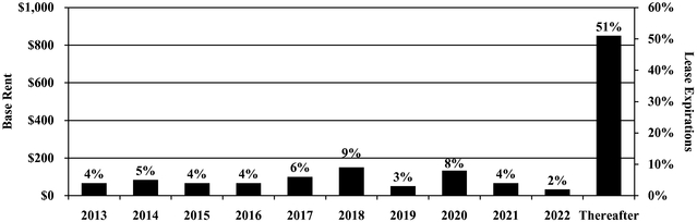
We specifically incorporate by reference into this section the information set forth in Schedule III: Real Estate and Accumulated Depreciation, included in this report.
We are involved from time-to-time in legal proceedings that arise in the ordinary course of our business, including, but not limited to commercial disputes, environmental matters, and litigation in connection with transactions including acquisitions and divestitures. We believe that such existing legal proceedings will not have a material adverse impact on our financial position or our results of operations. We record a liability when a loss is considered probable and the amount can be reasonably estimated.
See litigation matter under the heading "Legal Proceedings" of Note 12 to the Consolidated Financial Statements for information regarding legal proceedings, which information is incorporated by reference in this Item 3.
ITEM 4. Mine Safety Disclosures
None.
32
ITEM 5. Market for Registrant's Common Equity, Related Stockholder Matters and Issuer Purchases of Equity Securities
Our common stock is listed on the New York Stock Exchange. Set forth below for the fiscal quarters indicated are the reported high and low sales prices per share of our common stock on the New York Stock Exchange.
|
2012 | 2011 | 2010 | ||||||||||||||||
---|---|---|---|---|---|---|---|---|---|---|---|---|---|---|---|---|---|---|---|
|
High | Low | High | Low | High | Low | |||||||||||||
First Quarter |
$ | 42.75 | $ | 38.72 | $ | 38.29 | $ | 35.81 | $ | 34.37 | $ | 26.70 | |||||||
Second Quarter |
44.15 | 37.81 | 40.75 | 35.00 | 34.50 | 28.53 | |||||||||||||
Third Quarter |
47.75 | 43.59 | 38.23 | 28.76 | 38.05 | 31.08 | |||||||||||||
Fourth Quarter |
46.15 | 43.31 | 41.98 | 32.66 | 37.65 | 31.87 |
At February 1, 2013, we had approximately 11,298 stockholders of record and there were approximately 188,236 beneficial holders of our common stock.
It has been our policy to declare quarterly dividends to the common stockholders so as to comply with applicable provisions of the Code governing REITs. The cash dividends per share paid on common stock are set forth below:
|
2012 | 2011 | 2010 | |||||||
---|---|---|---|---|---|---|---|---|---|---|
First Quarter |
$ | 0.50 | $ | 0.48 | $ | 0.465 | ||||
Second Quarter |
0.50 | 0.48 | 0.465 | |||||||
Third Quarter |
0.50 | 0.48 | 0.465 | |||||||
Fourth Quarter |
0.50 | 0.48 | 0.465 | |||||||
Total |
$ | 2.00 | $ | 1.92 | $ | 1.86 | ||||
On January 25, 2013, we announced that our Board of Directors declared a quarterly common stock cash dividend of $0.525 per share. The common stock dividend will be paid on February 19, 2013 to stockholders of record as of the close of business on February 4, 2013.
Recent Sales of Unregistered Securities
On December 11, 2012, we issued 194,374 shares of our common stock upon the redemption of 194,374 non-managing member units of our subsidiary, HCP DR Alabama, LLC ("HCP Alabama"), to a non-managing member of HCP Alabama. On December 18, 2012, we issued 540 shares of our common stock upon the redemption of 270 non-managing member units of our subsidiary, HCPI/Utah II, LLC ("Utah II"), to four transferees of a non-managing member of Utah II. In each case, the shares of our common stock were issued in a private placement to an accredited investor pursuant to Section 4(2) of the Securities Act of 1933, as amended. We did not receive any cash proceeds from the issuance of shares of our common stock upon redemption of the non-managing member units of HCP Alabama or Utah II, although we did acquire non-managing member units of each subsidiary in exchange for the shares of common stock we issued upon redemption of the units.
33
Issuer Purchases of Equity Securities
The table below sets forth the information with respect to purchases of our common stock made by or on our behalf during the quarter ended December 31, 2012.
ISSUER PURCHASES OF EQUITY SECURITIES
Period Covered
|
Total Number Of Shares Purchased(1) |
Average Price Paid Per Share |
Total Number Of Shares Purchased As Part Of Publicly Announced Plans Or Programs |
Maximum Number (Or Approximate Dollar Value) Of Shares That May Yet Be Purchased Under The Plans Or Programs |
|||||||||
---|---|---|---|---|---|---|---|---|---|---|---|---|---|
November 1-30, 2012 |
233 | $ | 44.01 | | | ||||||||
December 1-31, 2012 |
165,038 | 45.16 | | | |||||||||
Total |
165,271 | 45.16 | | | |||||||||
Stock Price Performance Graph
The graph below compares the cumulative total return of HCP, the S&P 500 Index and the Equity REIT Index of the National Association of Real Estate Investment Trusts, Inc. ("NAREIT"), from January 1, 2008 to December 31, 2012. Total return assumes quarterly reinvestment of dividends before consideration of income taxes.
COMPARISON OF FIVE-YEAR CUMULATIVE TOTAL RETURN
AMONG S&P 500, EQUITY REITS AND HCP, Inc.
RATE OF RETURN TREND COMPARISON
JANUARY 1,
2008DECEMBER 31, 2012
(JANUARY 1, 2008 = 100)
Stock Price Performance Graph Total Return
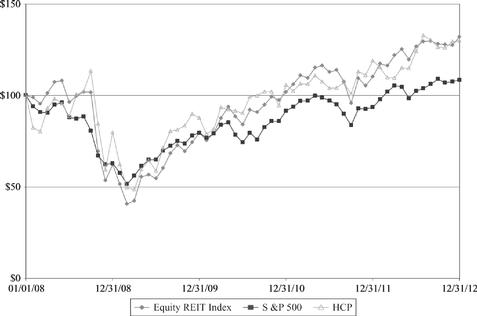
Assumes $100 invested January 1, 2008 in HCP, S&P 500 Index and NAREIT Equity REIT Index.
34
ITEM 6. Selected Financial Data
Set forth below is our selected financial data as of and for each of the years in the five year period ended December 31, 2012.
|
Year Ended December 31,(1)(2) | |||||||||||||||
---|---|---|---|---|---|---|---|---|---|---|---|---|---|---|---|---|
|
2012 | 2011(3) | 2010 | 2009(3) | 2008 | |||||||||||
|
(Dollars in thousands, except per share data) |
|||||||||||||||
Income statement data: |
||||||||||||||||
Total revenues |
$ | 1,900,722 | $ | 1,712,096 | $ | 1,240,206 | $ | 1,133,618 | $ | 1,123,977 | ||||||
Income from continuing operations |
812,884 | 547,338 | 315,346 | 97,732 | 223,019 | |||||||||||
Net income applicable to common shares |
812,289 | 515,302 | 307,498 | 109,069 | 425,368 | |||||||||||
Income from continuing operations applicable to common shares: |
||||||||||||||||
Basic earnings per common share |
1.83 | 1.28 | 0.91 | 0.22 | 0.75 | |||||||||||
Diluted earnings per common share |
1.83 | 1.28 | 0.91 | 0.22 | 0.75 | |||||||||||
Net income applicable to common shares: |
||||||||||||||||
Basic earnings per common share |
1.90 | 1.29 | 1.01 | 0.40 | 1.79 | |||||||||||
Diluted earnings per common share |
1.90 | 1.29 | 1.00 | 0.40 | 1.79 | |||||||||||
Balance sheet data: |
||||||||||||||||
Total assets |
19,915,555 | 17,408,475 | 13,331,923 | 12,209,735 | 11,849,826 | |||||||||||
Debt obligations(4) |
8,693,820 | 7,722,619 | 4,646,345 | 5,656,143 | 5,937,456 | |||||||||||
Total equity |
10,753,777 | 9,220,622 | 8,146,047 | 5,958,609 | 5,407,840 | |||||||||||
Other data: |
||||||||||||||||
Dividends paid |
865,306 | 787,689 | 590,735 | 517,072 | 457,643 | |||||||||||
Dividends paid per common share |
2.00 | 1.92 | 1.86 | 1.84 | 1.82 |
35
ITEM 7. Management's Discussion and Analysis of Financial Condition and Results of Operations
Cautionary Language Regarding Forward-Looking Statements
Statements in this Annual Report on Form 10-K that are not historical factual statements are "forward-looking statements." We intend to have our forward-looking statements covered by the safe harbor provisions of the Private Securities Litigation Reform Act of 1995 and include this statement for purposes of complying with those provisions. Forward-looking statements include, among other things, statements regarding our and our officers' intent, belief or expectations as identified by the use of words such as "may," "will," "project," "expect," "believe," "intend," "anticipate," "seek," "forecast," "plan," "estimate," "could," "would," "should" and other comparable and derivative terms or the negatives thereof. In addition, we, through our officers, from time to time, make forward-looking oral and written public statements concerning our expected future operations, strategies, securities offerings, growth and investment opportunities, dispositions, capital structure changes, budgets and other developments. Readers are cautioned that, while forward-looking statements reflect our good faith belief and reasonable assumptions based upon current information, we can give no assurance that our expectations or forecasts will be attained. Therefore, readers should be mindful that forward-looking statements are not guarantees of future performance and that they are subject to known and unknown risks and uncertainties that are difficult to predict. As more fully set forth in Part I, Item 1A., "Risk Factors" in this report, factors that may cause our actual results to differ materially from the expectations contained in the forward-looking statements include:
36
Except as required by law, we undertake no, and hereby disclaim any, obligation to update any forward-looking statements, whether as a result of new information, changed circumstances or otherwise.
The information set forth in this Item 7 is intended to provide readers with an understanding of our financial condition, changes in financial condition and results of operations. We will discuss and provide our analysis in the following order:
Executive Summary
We are a self-administered REIT that, together with our unconsolidated joint ventures, invests primarily in real estate serving the healthcare industry in the U.S. We acquire, develop, lease, manage and dispose of healthcare real estate and provide financing to healthcare providers. At December 31, 2012, our portfolio of investments, including properties owned by our Investment Management Platform, consisted of interests in 1,160 facilities.
Our business strategy is based on three principles: (i) opportunistic investing, (ii) portfolio diversification, and (iii) conservative financing. We actively redeploy capital from investments with lower return potential or shorter investment horizons into assets representing longer term investments with attractive risk adjusted return potential. We make investments where the expected risk-adjusted
37
return exceeds our cost of capital and strive to capitalize on our operator, tenant and other business relationships to grow our business.
Our strategy contemplates acquiring and developing properties on terms that are favorable to us. Generally, we prefer larger, more complex private transactions that leverage our management team's experience and our infrastructure. We follow a disciplined approach to enhancing the value of our existing portfolio, including ongoing evaluation of potential disposition of properties that no longer fit our strategy.
We primarily generate revenue by leasing healthcare properties under long-term leases with fixed and/or inflation indexed escalators. Most of our rents and other earned income from leases are received under triple-net leases or leases that provide for substantial recovery of operating expenses; however, some of our medical office and life science leases are structured as gross or modified gross leases. Operating expenses are generally related to MOB and life science leased properties and senior housing properties managed on our behalf ("RIDEA properties"). Accordingly, for such MOBs, life science facilities and RIDEA properties, we incur certain property operating expenses, such as real estate taxes, repairs and maintenance, property management fees, utilities, employee costs for resident care and insurance. Our growth for these assets depends, in part, on our ability to (i) increase rental income and other earned income from leases by increasing rental rates and occupancy levels; (ii) maximize tenant recoveries given underlying lease structures; and (iii) control operating and other expenses. Our operations are impacted by property specific, market specific, general economic and other conditions. At December 31, 2012, the contractual maturities in our portfolio of leased assets were 13% through 2015 (measured in dollars of expiring base rents).
Access to capital markets impacts our cost of capital and ability to refinance maturing indebtedness, as well as to fund future acquisitions and development through the issuance of additional securities or secured debt. Access to external capital on favorable terms is critical to the success of our strategy.
2012 Transaction Overview
Investment Transactions
During the year ended December 31, 2012, we completed $2.6 billion of investments as follows:
$1.7 Billion Senior Housing Portfolio Acquisition and $52 Million Secured Financing
During the fourth quarter of 2012, we acquired 129 senior housing communities for $1.7 billion, from a joint venture between Emeritus and the Blackstone JV. Located in 29 states, the portfolio encompasses 10,077 units representing a diversified care mix of 61% assisted living, 25% independent living, 13% memory care and 1% skilled nursing. Based on current operating performance, the 129 communities consist of 95 that are stabilized and 34 that are currently in leaseup. The transaction closed in two stages: (i) 127 senior housing facilities on October 31, 2012 for $1.68 billion representing 9,842 units; and (ii) two senior housing facilities on December 4, 2012 for $24 million representing 235 units.
Emeritus continues to operate the communities pursuant to a new triple-net, master lease for the 129 properties (the "Master Lease") guaranteed by Emeritus. The Master Lease provides aggregate contractual rent in the first year of $103.6 million. The contractual rent will increase annually by the greater of the percentage increase in the Consumer Price Index ("CPI") or 3.7% on average over the initial five years, and thereafter by the greater of CPI or 3.0% for the remaining initial lease term. At the beginning of the sixth lease year, rent on the 34 lease-up properties will increase to the greater of the percentage increase in CPI or fair market, subject to a floor of 103% and a cap of 130% of the prior year's rent.
38
The leased properties are grouped into three pools that share comparable characteristics and these leased pools have initial terms of 14 to 16 years. Emeritus has two extension options, which, if exercised, will provide for lease terms of 30 to 35 years. We are still evaluating the acquisition of up to four additional communities related to this transaction.
Concurrent with the acquisition, Emeritus purchased nine communities from the Blackstone JV, for which we have provided secured debt financing of $52 million with a four-year term. The loan is secured by the underlying real estate and is prepayable at Emeritus' option. The interest rate on the loan mirrors the 6.1% lease yield, including the annual increases through maturity.
$853 Million of Additional Investment Transactions
On August 7, 2012, we completed the acquisition of eight on-campus MOBs for $80 million from Scottsdale Healthcare. Located in Scottsdale, Arizona, the portfolio represents 398,000 square feet with an occupancy of 89% at closing.
Between July and October 2012, we acquired 12 MOBs from The Boyer Company valued at $188 million, including DownREIT units and debt valued at $43 million and $60 million, respectively; the MOBs are primarily located on the campuses of HCA, Iasis Healthcare and Community Health Systems and comprise 758,000 square feet with an occupancy of 88% at closing. The transaction closed in three stages: (i) six MOBs on July 31, 2012 for $77 million representing 327,000 square feet; (ii) four MOBs on August 15, 2012 for $49 million representing 199,000 square feet and; (iii) two MOBs on October 19, 2012 for $62 million representing 232,000 square feet.
On July 31, 2012, we closed a mezzanine loan facility to lend up to $205 million to Tandem Health Care ("Tandem"), an affiliate of Formation Capital, as part of the recapitalization of a post-acute/skilled nursing portfolio. We funded $100 million (the "First Tranche") at closing and have a commitment to fund an additional $105 million (the "Second Tranche") between February 2013 and August 2013. The Second Tranche will be used to repay debt senior to our loan. At closing, the loan was subordinate to $400 million in senior mortgage debt and $137 million in senior mezzanine debt. The loan bears interest at a fixed rate of 12% and 14% per annum for the First and Second Tranches, respectively. Including fees received at closing, the loan has a blended yield to maturity of approximately 13% assuming both tranches are funded. The facility has a total term of up to 63 months from the initial closing and is prepayable at the borrower's option.
On June 28, 2012, we made an investment in senior unsecured notes with an aggregate par value of £138.5 million at a discount for £136.8 million, as part of the financing for Terra Firma's £825 million acquisition of Four Seasons Health Care ("Four Seasons"), the largest elderly and specialist care provider in the United Kingdom with 445 care homes and 61 specialist care centers. The notes mature in June 2020 and are non-callable until June 2016. The notes bear interest on their par value at a fixed rate of 12.25% per annum, with an original discount resulting in a yield to maturity of 12.5%. Terra Firma, a leading European private equity firm, provided £345 million in equity financing, resulting in a loan-to-capitalization of 62% for the Four Seasons notes. The £136.8 million for this investment is match funded by an equivalent GBP denominated unsecured term loan discussed below.
During the year ended December 31, 2012, we made other investments of $270 million as follows: (i) acquisition of a MOB for $13 million; (ii) acquisition of a life science facility for $8 million; (iii) acquisition of a senior housing facility for $4 million; (iv) acquisition of a parcel of land adjacent to one of our hospitals for $3 million; and (v) funding of development and other capital projects of $242 million, primarily in our life science, senior housing and medical office segments.
39
Other Transactions
During the year ended December 31, 2012, we sold two senior housing facilities for $111 million, a parcel of land in our life science segment for $18 million, a skilled nursing facility for $15 million and a MOB for $7 million.
During the year ended December 31, 2012, we expanded our tenant relationship with General Atomics in Poway, CA to a total of 396,000 square feet, consisting of the following: (i) a lease extension of 281,000 square feet through June 2024, and (ii) a new 10-year lease (expected to commence mid-2014) for a 115,000 square feet build-to-suit development. As part of this transaction, General Atomics purchased a 19-acre land parcel from us for $18 million; in connection with the agreement to sell the land parcel, we incurred a $7.9 million impairment charge.
Financings
During the year ended December 31, 2012, we raised $3.5 billion of capital in the equity and credit markets as follows:
In connection with funding the $1.7 billion Senior Housing Portfolio acquisition, we completed the following capital market transactions:
On July 30, 2012, in connection with our Four Seasons senior unsecured notes investment, we entered into a credit agreement with a syndicate of banks for a £137 million four-year unsecured term loan (the "Term Loan") that accrues interest at a rate of GBP London Interbank Offered Rate ("LIBOR") plus 1.20%, based on our current debt ratings. Concurrent with the closing of the Term Loan, we entered into a four-year interest rate swap agreement that fixes the rate of the Term Loan at 1.81%, subject to adjustments based on our credit ratings. The Term Loan contains a one-year committed extension option and similar covenants to those in our unsecured revolving line of credit facility.
On July 23, 2012, we issued $300 million of 3.15% senior unsecured notes due in 2022. The notes were priced at 98.888% of the principal amount with an effective yield to maturity of 3.28%. Net proceeds from this offering were $294 million.
In June 2012, we completed a $376 million offering of 8.97 million shares of common stock at $41.88 per share with the proceeds used primarily to repay $250 million of 6.45% senior unsecured notes at maturity on June 25, 2012.
On March 27, 2012, we completed an amendment to our existing $1.5 billion unsecured revolving line of credit facility. We improved the pricing and extended the maturity of the facility one additional year to March 2016. Based on our current credit ratings, the amended facility bears interest annually at one-month LIBOR plus 1.075% and has a facility fee of 0.175%, which in the aggregate represents a 55 basis point reduction to our funded interest cost.
On March 22, 2012, we announced the redemption of the 4.0 million shares of 7.25% Series E and 7.82 million shares of 7.10% Series F preferred stock at a price of $25.00 per share, or $295.5 million in aggregate, plus all accrued and unpaid dividends to April 23, 2012 (the redemption date). As a result of the redemption, we incurred a charge of $10.4 million related to the original issuance costs of the
40
preferred stock (this charge is presented as an additional preferred stock dividend in our consolidated statements of income).
On March 22, 2012, we priced a $359 million offering of 9.0 million shares of common stock at $39.93 per share with the proceeds used primarily to redeem all outstanding shares of our preferred stock.
On January 23, 2012, we issued $450 million of 3.75% senior unsecured notes due in 2019; net proceeds from the offering were $444 million.
Dividends
Quarterly dividends paid during 2012 aggregated $2.00 per share, which represents a 4.2% increase from 2011. On January 25, 2013, we announced that our Board of Directors declared a quarterly common stock cash dividend of $0.525 per share, which represents a 5% increase. The common stock dividend will be paid on February 19, 2013 to stockholders of record as of the close of business on February 4, 2013. Based on the first quarter's dividend, the annualized rate of distribution for 2013 is $2.10, compared with $2.00 in 2012.
Critical Accounting Policies
The preparation of financial statements in conformity with U.S. generally accepted accounting principles ("GAAP") requires our management to use judgment in the application of accounting policies, including making estimates and assumptions. We base estimates on the best information available to us at the time, our experience and on various other assumptions believed to be reasonable under the circumstances. These estimates affect the reported amounts of assets and liabilities, disclosure of contingent assets and liabilities at the date of the financial statements and the reported amounts of revenue and expenses during the reporting periods. If our judgment or interpretation of the facts and circumstances relating to various transactions or other matters had been different, it is possible that different accounting would have been applied, resulting in a different presentation of our consolidated financial statements. From time to time, we re-evaluate our estimates and assumptions. In the event estimates or assumptions prove to be different from actual results, adjustments are made in subsequent periods to reflect more current estimates and assumptions about matters that are inherently uncertain. For a more detailed discussion of our significant accounting policies, see Note 2 to the Consolidated Financial Statements. Below is a discussion of accounting policies that we consider critical in that they may require complex judgment in their application or require estimates about matters that are inherently uncertain.
Principles of Consolidation
The consolidated financial statements include the accounts of HCP, Inc., our wholly owned subsidiaries and joint ventures that we control, through voting rights or other means. We consolidate investments in variable interest entities ("VIEs") when we are the primary beneficiary of the VIE at: (i) the inception of the variable interest entity, (ii) as a result of a change in circumstance identified during our continuous review of our VIE relationships or (iii) upon the occurrence of a qualifying reconsideration event.
We make judgments with respect to our level of influence or control of an entity and whether we are (or are not) the primary beneficiary of a VIE. Consideration of various factors includes, but is not limited to, our ability to direct the activities that most significantly impact the entity's economic performance, our form of ownership interest, our representation on the entity's governing body, the size and seniority of our investment, our ability and the rights of other investors to participate in policy making decisions, replace the manager and/or liquidate the entity, if applicable. Our ability to correctly assess our influence or control over an entity when determining the primary beneficiary of a VIE
41
affects the presentation of these entities in our consolidated financial statements. If we perform a primary beneficiary analysis at a date other than at inception of the variable interest entity, our assumptions may be different and may result in the identification of a different primary beneficiary.
If we determine that we are the primary beneficiary of a VIE, our consolidated financial statements would include the operating results of the VIE (either tenant or borrower) rather than the results of the variable interest in the VIE. We would depend on the VIE to provide us timely financial information and rely on the internal control of the VIE to provide accurate financial information. If the VIE has deficiencies in its internal control over financial reporting, or does not provide us with timely financial information, this may adversely impact the quality and/or timing of our financial reporting and our internal control over financial reporting.
Revenue Recognition
We recognize rental revenue on a straight-line basis over the lease term when collectibility is reasonably assured and the tenant has taken possession or controls the physical use of the leased asset. For assets acquired subject to leases, we recognize revenue upon acquisition of the asset provided the tenant has taken possession or controls the physical use of the leased asset. If the lease provides for tenant improvements, we determine whether the tenant improvements, for accounting purposes, are owned by the tenant or us. When we are the owner of the tenant improvements, the tenant is not considered to have taken physical possession or have control of the physical use of the leased asset until the tenant improvements are substantially completed. When the tenant is the owner of the tenant improvements, any tenant improvement allowance funded is treated as a lease incentive and amortized as a reduction of revenue over the lease term. The determination of ownership of the tenant improvements is subject to significant judgment. If our assessment of the owner of the tenant improvements for accounting purposes were to change, the timing and amount of our revenue recognized would be impacted.
Certain leases provide for additional rents contingent upon a percentage of the facility's revenue in excess of specified base amounts or other thresholds. Such revenue is recognized when actual results reported by the tenant, or estimates of tenant results, exceed the base amount or other thresholds. The recognition of additional rents requires us to make estimates of amounts owed and to a certain extent are dependent on the accuracy of the facility results reported to us. Our estimates may differ from actual results, which could be material to our consolidated financial statements.
We maintain an allowance for doubtful accounts, including an allowance for straight-line rent receivables, for estimated losses resulting from tenant defaults or the inability of tenants to make contractual rent and tenant recovery payments. We monitor the liquidity and creditworthiness of our tenants and operators on an ongoing basis. This evaluation considers industry and economic conditions, property performance, credit enhancements and other factors. For straight-line rent amounts, our assessment is based on income recoverable over the term of the lease. We exercise judgment in establishing allowances and consider payment history and current credit status in developing these estimates. These estimates may differ from actual results, which could be material to our consolidated financial statements.
Loans receivable are classified as held-for-investment based on management's intent and ability to hold the loans for the foreseeable future or to maturity. We recognize interest income on loans, including the amortization of discounts and premiums, using the interest method applied on a loan-by-loan basis when collectibility of the future payments is reasonably assured. Premiums, discounts and related costs are recognized as yield adjustments over the life of the related loans.
We use the direct finance method of accounting to record income from DFLs. For leases accounted for as DFLs, future minimum lease payments are recorded as a receivable. The difference between the future minimum lease payments and the estimated residual values less the cost of the
42
properties is recorded as unearned income. Unearned income is deferred and amortized to income over the lease terms to provide a constant yield when collectibility of the lease payments is reasonably assured. Investments in DFLs are presented net of unamortized unearned income. The determination of estimated useful lives and residual values are subject to significant judgment. If our assessments for accounting purposes were to change, the timing and amount of our revenue recognized would be impacted.
Loans and DFLs are placed on non-accrual status at such time as management determines that collectibility of contractual amounts is not reasonably assured. While on non-accrual status, loans or DFLs are either accounted for on a cash basis, in which income is recognized only upon receipt of cash, or on a cost-recovery basis, in which all cash receipts reduce the carrying value of the loan or DFL, based on management's judgment of collectibility.
Allowances are established for loans and DFLs based upon a probable loss estimate for individual loans and DFLs deemed to be impaired. Loans and DFLs are impaired when it is deemed probable that we will be unable to collect all amounts due on a timely basis in accordance with the contractual terms of the loan or lease. Determining the adequacy of the allowance is complex and requires significant judgment by us about the effect of matters that are inherently uncertain. The allowance is based upon our assessment of the borrower's or lessee's overall financial condition, resources and payment record; the prospects for support from any financially responsible guarantors; and, if appropriate, the realizable value of any collateral. These estimates consider all available evidence including, as appropriate, the present value of the expected future cash flows discounted at the loan's or DFL's effective interest rate, the fair value of collateral, general economic conditions and trends, historical and industry loss experience, and other relevant factors. While our assumptions are based in part upon historical data, our estimates may differ from actual results, which could be material to our consolidated financial statements.
Real Estate
We make estimates as part of our allocation of the purchase price of acquisitions to the various components of the acquisition based upon the relative fair value of each component. The most significant components of our allocations are typically the allocation of fair value to the buildings as-if-vacant, land and in-place leases. In the case of the fair value of buildings and the allocation of value to land and other intangibles, our estimates of the values of these components will affect the amount of depreciation and amortization we record over the estimated useful life of the property acquired or the remaining lease term. In the case of the value of in-place leases, we make our best estimates based on our evaluation of the specific characteristics of each tenant's lease. Factors considered include estimates of carrying costs during hypothetical expected lease-up periods, market conditions and costs to execute similar leases. Our assumptions affect the amount of future revenue that we will recognize over the remaining lease term for the acquired in-place leases.
A variety of costs are incurred in the development and leasing of properties. After determination is made to capitalize a cost, it is allocated to the specific component of a project that is benefited. Determination of when a development project is substantially complete and capitalization must cease involves a degree of judgment. The costs of land and buildings under development include specifically identifiable costs. The capitalized costs include pre-construction costs essential to the development of the property, development costs, construction costs, interest costs, real estate taxes and other costs incurred during the period of development. We consider a construction project as substantially completed and held available for occupancy and cease capitalization of costs upon the completion of the related tenant improvements.
43
Impairment of Long-Lived Assets and Goodwill
We assess the carrying value of our real estate assets and related intangibles ("real estate assets"), whenever events or changes in circumstances indicate that the carrying amount of an asset or asset group may not be recoverable. Recoverability of real estate assets is measured by comparison of the carrying amount of the asset or asset group to the respective estimated future undiscounted cash flows. In order to review our real estate assets for recoverability, we consider market conditions, as well as our intent with respect to holding or disposing of the asset. Fair value is determined through various valuation techniques, including discounted cash flow models, quoted market values and third party appraisals, where considered necessary. If our analysis indicates that the carrying value of the real estate asset is not recoverable on an undiscounted cash flow basis, we recognize an impairment charge for the amount by which the carrying value exceeds the fair value of the real estate asset.
Goodwill is tested for impairment at least annually. If it is determined, based on certain qualitative factors, that it is more likely than not that the fair value of a reporting unit is less than its carrying amount, we apply the two-step approach. Certain qualitative factors assessed by us include current macroeconomic conditions, state of the equity and capital markets and the overall financial and operating performance of HCP. If we qualitatively determine that it is more likely than not the fair value of a reporting unit is less than its carrying amount the two-step approach is necessary.
If the fair value of a reporting unit containing goodwill is less than its carrying value, then the second step of the test is needed to measure the amount of potential goodwill impairment. The second step requires the fair value of a reporting unit to be allocated to all the assets and liabilities of the reporting unit as if the reporting unit had been acquired in a business combination at the date of the impairment test. The excess of the fair value of the reporting unit over the fair value of assets and liabilities is the implied value of goodwill and is used to determine the amount of impairment. We estimate the current fair value of the assets and liabilities in the reporting unit through various valuation techniques, including applying capitalization rates to segment net operating income, quoted market values and third-party appraisals, as necessary. The fair value of the reporting unit may also include an allocation of an enterprise value premium that we estimate a third party would be willing to pay for the company.
The determination of the fair value of real estate assets and goodwill involves significant judgment. This judgment is based on our analysis and estimates of fair value of real estate assets and reporting units, and the future operating results and resulting cash flows of each real estate asset whose carrying amount may not be recoverable. Our ability to accurately predict future operating results and cash flows and estimate and allocate fair values impacts the timing and recognition of impairments. While we believe our assumptions are reasonable, changes in these assumptions may have a material impact on our financial results.
Investments in Unconsolidated Joint Ventures
Investments in entities which we do not consolidate but have the ability to exercise significant influence over operating and financial policies are reported under the equity method of accounting. Under the equity method of accounting, our share of the investee's earnings or losses is included in our consolidated results of operations.
The initial carrying value of investments in unconsolidated joint ventures is based on the amount paid to purchase the joint venture interest or the carrying value of the assets prior to the sale of interests in the joint venture. We evaluate our equity method investments for impairment based upon a comparison of the fair value of the equity method investment to our carrying value. If we determine a decline in the fair value of our investment in an unconsolidated joint venture is below its carrying value is other-than-temporary, an impairment is recorded. The determination of the fair value and as to whether a deficiency in fair value is "other-than-temporary" of investments in unconsolidated joint
44
ventures involves significant judgment. Our estimates consider all available evidence including, as appropriate, the present value of the expected future cash flows discounted at market rates, general economic conditions and trends, severity and duration of the fair value deficiency, and other relevant factors. Capitalization rates, discount rates and credit spreads utilized in our valuation models are based upon rates that we believe to be within a reasonable range of current market rates for the respective investments. While we believe our assumptions are reasonable, changes in these assumptions may have a material impact on our financial results.
Income Taxes
As part of the process of preparing our consolidated financial statements, significant management judgment is required to evaluate our compliance with REIT requirements. Our determinations are based on interpretation of tax laws, and our conclusions may have an impact on the income tax expense recognized. Adjustments to income tax expense may be required as a result of: (i) audits conducted by federal, state and local tax authorities, (ii) our ability to qualify as a REIT, (iii) the potential for built-in-gain recognized related to prior-tax-free acquisitions of C corporations, and (iv) changes in tax laws. Adjustments required in any given period are included within the income tax provision.
Results of Operations
We evaluate our business and allocate resources among our five business segments: (i) senior housing, (ii) post-acute/skilled nursing, (iii) life science, (iv) medical office and (v) hospital. Under the senior housing, life science, post-acute/skilled nursing and hospital segments, we invest or co-invest primarily in single operator or tenant properties, through the acquisition and development of real estate, management of operations and by debt issued by operators in these sectors. Under the medical office segment, we invest or co-invest through the acquisition and development of MOBs that are leased under gross, modified gross or triple-net leases, generally to multiple tenants, and which generally require a greater level of property management. The accounting policies of the segments are the same as those described in the summary of significant accounting policies (see Note 2 to the Consolidated Financial Statements).
We use net operating income ("NOI") and adjusted NOI to assess and compare property level performance, including our same property portfolio ("SPP"), and to make decisions about resource allocations. We believe these measures provide investors relevant and useful information because they reflect only income and operating expense items that are incurred at the property level and present them on an unleveraged basis. We believe that net income is the most directly comparable GAAP measure to NOI. NOI should not be viewed as an alternative measure of operating performance to net income as defined by GAAP since NOI excludes certain components from net income. Further, NOI may not be comparable to that of other REITs, as they may use different methodologies for calculating NOI. See Note 14 to the Consolidated Financial Statements for additional segment information and the relevant reconciliations from net income to NOI and adjusted NOI.
Operating expenses are generally related to MOB and life science leased properties and senior housing properties managed on our behalf (RIDEA properties). We generally recover all or a portion of MOB and life science expenses from the tenants (tenant recoveries). The presentation of expenses as operating or general and administrative is based on the underlying nature of the expense. Periodically, we review the classification of expenses between categories and make revisions based on changes in the underlying nature of the expenses.
Our evaluation of results of operations by each business segment includes an analysis of our SPP and our total property portfolio. SPP information allows us to evaluate the performance of our leased property portfolio under a consistent population by eliminating changes in the composition of our portfolio of properties. We identify our SPP as stabilized properties that remained in operations and
45
were consistently reported as leased properties or RIDEA properties for the duration of the year-over-year comparison periods presented. Accordingly, it takes a stabilized property a minimum of 12 months in operations under a consistent reporting structure to be included in our SPP. Newly acquired operating assets are generally considered stabilized at the earlier of lease-up (typically when the tenant(s) controls the physical use of at least 80% of the space) or 12 months from the acquisition date. Newly completed developments, including redevelopments, are considered stabilized at the earlier of lease-up or 24 months from the date the property is placed in service. SPP NOI excludes certain non-property specific operating expenses that are allocated to each operating segment on a consolidated basis.
Comparison of the Year Ended December 31, 2012 to the Year Ended December 31, 2011
During the fourth quarter of 2012, we acquired 129 senior housing communities from the Blackstone JV (see additional information in Note 4 to the Consolidated Financial Statements). The transaction closed in two stages: (i) 127 senior housing facilities on October 31, 2012; and (ii) two senior housing facilities on December 4, 2012. The results of operations from the acquisitions are reflected in our consolidated financial statements from those respective dates.
On April 7, 2011, we completed our acquisition of substantially all of HCR ManorCare's real estate assets; additionally, we purchased a noncontrolling equity interest in the operations of HCR ManorCare. On January 14, 2011, we acquired our partner's 65% interest in HCP Ventures II that resulted in the consolidation of HCP Ventures II. On September 1, 2011, we entered into management contracts with Brookdale with respect to 21 senior living communities (these 21 communities were acquired in January 2011 as part of our purchase of HCP Ventures II). These 21 communities are now in a RIDEA structure are managed by Brookdale, the respective resident level revenues and related operating expenses are reported in our consolidated financial statements. See additional information regarding the HCR ManorCare Acquisition, HCP Ventures II purchase and the Brookdale RIDEA transaction in Notes 3, 8 and 12, respectively, to the Consolidated Financial Statements. The results of operations from our HCR ManorCare, HCP Ventures II and 21 properties managed under a RIDEA structure are reflected in our financial statements from those respective dates.
Segment NOI and Adjusted NOI
The tables below provide selected operating information for our SPP and total property portfolio for each of our five business segments. Our consolidated SPP consists of 565 properties representing properties acquired or placed in service and stabilized on or prior to January 1, 2011 and that remained in operations under a consistent reporting structure through December 31, 2012. Our consolidated total property portfolio represents 1,086 and 932 properties at December 31, 2012 and 2011, respectively, and excludes properties classified as discontinued operations.
46
Senior Housing
Results are as of and for the year ended December 31, 2012 and 2011 (dollars in thousands except per unit data):
|
SPP | Total Portfolio | |||||||||||||||||
---|---|---|---|---|---|---|---|---|---|---|---|---|---|---|---|---|---|---|---|
|
2012 | 2011 | Change | 2012 | 2011 | Change | |||||||||||||
Rental revenues(1) |
$ | 380,413 | $ | 378,553 | $ | 1,860 | $ | 482,336 | $ | 470,592 | $ | 11,744 | |||||||
Resident fees and services |
1,054 | 3,542 | (2,488 | ) | 143,745 | 50,619 | 93,126 | ||||||||||||
Total revenues |
$ | 381,467 | $ | 382,095 | $ | (628 | ) | $ | 626,081 | $ | 521,211 | $ | 104,870 | ||||||
Operating expenses |
(613 | ) | (1,052 | ) | 439 | (94,662 | ) | (34,538 | ) | (60,124 | ) | ||||||||
NOI |
$ | 380,854 | $ | 381,043 | $ | (189 | ) | $ | 531,419 | $ | 486,673 | $ | 44,746 | ||||||
Straight-line rents |
(24,740 | ) | (34,579 | ) | 9,839 | (30,415 | ) | (34,911 | ) | 4,496 | |||||||||
DFL accretion |
(6,863 | ) | (9,052 | ) | 2,189 | (18,812 | ) | (17,918 | ) | (894 | ) | ||||||||
Amortization of above and below market lease intangibles, net |
(1,569 | ) | (1,569 | ) | | (1,320 | ) | (1,466 | ) | 146 | |||||||||
Lease termination fees |
| | | | 1,350 | (1,350 | ) | ||||||||||||
Adjusted NOI |
$ | 347,682 | $ | 335,843 | $ | 11,839 | $ | 480,872 | $ | 433,728 | $ | 47,144 | |||||||
Adjusted NOI % change |
3.5 | % | |||||||||||||||||
Property count(2) |
221 | 221 | 441 | 312 | |||||||||||||||
Average capacity (units)(3) |
25,081 | 25,056 | 37,089 | 33,911 | |||||||||||||||
Average annual rent per unit(4) |
$ | 13,887 | $ | 13,446 | $ | 13,059 | $ | 12,887 |
SPP Adjusted NOI. SPP adjusted NOI improved primarily as a result of annual rent escalations and an increase in rental revenues from properties that were previously transitioned from Sunrise to other operators, partially offset by a decrease in additional rents.
Total Portfolio NOI and Adjusted NOI. Including the impact of our SPP, our total portfolio NOI and adjusted NOI for the year ended December 31, 2012 primarily increased as a result of 66 senior housing leased properties classified as DFLs that were acquired on April 7, 2011 from HCR ManorCare and 127 senior housing communities acquired on October 31, 2012 and two senior housing communities acquired on December 4, 2012 from the Blackstone JV (see Notes 3, 4 and 6 to the Consolidated Financial Statements for additional information regarding the HCR ManorCare Acquisition, the Blackstone JV acquisition and Net Investments in DFLs, respectively).
Additionally, HCP Ventures II was consolidated on January 14, 2011 (see Note 8 to the Consolidated Financial Statements for additional information), resulting in us recognizing rental and related revenues for the 25 leased properties commencing on that date. On September 1, 2011, for 21 of these 25 properties, we entered into management contracts in a structure permitted by RIDEA (see Note 12 to the Consolidated Financial Statements for additional information), resulting in the termination of the properties' leases. For these 21 properties that are now in a RIDEA structure, the resident-level revenues and related operating expenses are reported in our consolidated financial statements beginning on that date.
47
Post-Acute/Skilled Nursing
Results are as of and for the year ended December 31, 2012 and 2011 (dollars in thousands, except per bed data):
|
SPP | Total Portfolio | |||||||||||||||||
---|---|---|---|---|---|---|---|---|---|---|---|---|---|---|---|---|---|---|---|
|
2012 | 2011 | Change | 2012 | 2011 | Change | |||||||||||||
Rental revenues(1) |
$ | 37,387 | $ | 36,745 | $ | 642 | $ | 539,242 | $ | 397,554 | $ | 141,688 | |||||||
Operating expenses |
75 | (180 | ) | 255 | (386 | ) | (585 | ) | 199 | ||||||||||
NOI |
$ | 37,462 | $ | 36,565 | $ | 897 | $ | 538,856 | $ | 396,969 | $ | 141,887 | |||||||
Straight-line rents |
(547 | ) | (967 | ) | 420 | (547 | ) | (968 | ) | 421 | |||||||||
DFL accretion |
| | | (75,428 | ) | (56,089 | ) | (19,339 | ) | ||||||||||
Amortization of above and below market lease intangibles, net |
| | | 46 | 34 | 12 | |||||||||||||
Adjusted NOI |
$ | 36,915 | $ | 35,598 | $ | 1,317 | $ | 462,927 | $ | 339,946 | $ | 122,981 | |||||||
Adjusted NOI % change |
3.7 | % | |||||||||||||||||
Property count(2) |
44 | 44 | 312 | 312 | |||||||||||||||
Average capacity (beds)(3) |
5,031 | 5,061 | 39,856 | 30,565 | |||||||||||||||
Average annual rent per bed |
$ | 7,323 | $ | 7,069 | $ | 11,624 | $ | 11,140 |
SPP NOI and Adjusted NOI. SPP NOI and adjusted NOI increased year-over-year primarily as a result of rent escalations.
Total Portfolio NOI and Adjusted NOI. Including the impact of our SPP, our total portfolio NOI and adjusted NOI for the year ended December 31, 2012 primarily increased as a result of 268 post-acute/skilled nursing leased properties classified as DFLs that were acquired on April 7, 2011 from HCR ManorCare (see Notes 3 and 6 to the Consolidated Financial Statements for additional information regarding the HCR ManorCare Acquisition and Net Investments in DFLs, respectively, and discussion regarding our share in the earnings of our 9.4% interest in HCR ManorCare below under the caption "Equity income from unconsolidated joint ventures").
48
Life Science
Results are as of and for the year ended December 31, 2012 and 2011 (dollars and square feet in thousands, except per sq. ft. data):
|
SPP | Total Portfolio | |||||||||||||||||
---|---|---|---|---|---|---|---|---|---|---|---|---|---|---|---|---|---|---|---|
|
2012 | 2011 | Change | 2012 | 2011 | Change | |||||||||||||
Rental and related revenues |
$ | 243,469 | $ | 244,401 | $ | (932 | ) | $ | 246,811 | $ | 245,942 | $ | 869 | ||||||
Tenant recoveries |
42,164 | 41,882 | 282 | 42,853 | 42,209 | 644 | |||||||||||||
Total revenues |
$ | 285,633 | $ | 286,283 | $ | (650 | ) | $ | 289,664 | $ | 288,151 | $ | 1,513 | ||||||
Operating expenses |
(47,913 | ) | (49,123 | ) | 1,210 | (53,173 | ) | (52,796 | ) | (377 | ) | ||||||||
NOI |
$ | 237,720 | $ | 237,160 | $ | 560 | $ | 236,491 | $ | 235,355 | $ | 1,136 | |||||||
Straight-line rents |
(8,590 | ) | (14,685 | ) | 6,095 | (9,730 | ) | (14,971 | ) | 5,241 | |||||||||
Amortization of above and below market lease intangibles, net |
462 | (1,066 | ) | 1,528 | 411 | (1,123 | ) | 1,534 | |||||||||||
Lease termination fees |
(175 | ) | (7,011 | ) | 6,836 | (175 | ) | (7,011 | ) | 6,836 | |||||||||
Adjusted NOI |
$ | 229,417 | $ | 214,398 | $ | 15,019 | $ | 226,997 | $ | 212,250 | $ | 14,747 | |||||||
Adjusted NOI % change |
7.0 | % | |||||||||||||||||
Property count |
101 | 101 | 109 | 104 | |||||||||||||||
Average occupancy |
91.4 | % | 90.5 | % | 89.6 | % | 89.6 | % | |||||||||||
Average occupied square feet |
6,108 | 6,050 | 6,250 | 6,076 | |||||||||||||||
Average annual rent per occupied sq. ft. |
$ | 45 | $ | 44 | $ | 45 | $ | 44 |
SPP and Total Portfolio NOI and Adjusted NOI. NOI increased primarily as a result of lease expansions and extensions and a decline in non-reimbursable operating expenses, partially offset by a decline in lease termination fees. Adjusted NOI increased primarily as a result of a $4 million rent payment in connection with a February 2012 amendment to a lease, annual rent escalations, lease expansions and extensions, and a decline in non-reimbursable operating expenses.
During the year ended December 31, 2012, 978,000 square feet of new and renewal leases commenced at an average annual base rent of $21.71 per square foot compared to 776,000 square feet of expiring and terminated leases with an average annual base rent of $24.23 per square foot. During the year ended December 31, 2012, we acquired 77,000 square feet with an average annual base rent of $9.79 per square foot.
49
Medical Office
Results are as of and for the year ended December 31, 2012 and 2011 (dollars and square feet in thousands, except per sq. ft. data):
|
SPP | Total Portfolio | |||||||||||||||||
---|---|---|---|---|---|---|---|---|---|---|---|---|---|---|---|---|---|---|---|
|
2012 | 2011 | Change | 2012 | 2011 | Change | |||||||||||||
Rental and related revenues |
$ | 271,002 | $ | 265,851 | $ | 5,151 | $ | 285,331 | $ | 272,362 | $ | 12,969 | |||||||
Tenant recoveries |
45,509 | 46,186 | (677 | ) | 49,480 | 47,753 | 1,727 | ||||||||||||
Total revenues |
$ | 316,511 | $ | 312,037 | $ | 4,474 | $ | 334,811 | $ | 320,115 | $ | 14,696 | |||||||
Operating expenses |
(119,447 | ) | (118,894 | ) | (553 | ) | (132,264 | ) | (127,902 | ) | (4,362 | ) | |||||||
NOI |
$ | 197,064 | $ | 193,143 | $ | 3,921 | $ | 202,547 | $ | 192,213 | $ | 10,334 | |||||||
Straight-line rents |
(4,069 | ) | (5,473 | ) | 1,404 | (5,121 | ) | (5,691 | ) | 570 | |||||||||
Amortization of above and below market lease intangibles, net |
358 | 384 | (26 | ) | 457 | (130 | ) | 587 | |||||||||||
Lease termination fees |
(314 | ) | | (314 | ) | (314 | ) | (212 | ) | (102 | ) | ||||||||
Adjusted NOI |
$ | 193,039 | $ | 188,054 | $ | 4,985 | $ | 197,569 | $ | 186,180 | $ | 11,389 | |||||||
Adjusted NOI % change |
2.7 | % | |||||||||||||||||
Property count(1) |
183 | 183 | 207 | 187 | |||||||||||||||
Average occupancy |
91.4 | % | 90.9 | % | 91.1 | % | 90.9 | % | |||||||||||
Average occupied square feet |
11,642 | 11,556 | 12,295 | 11,865 | |||||||||||||||
Average annual rent per occupied sq. ft. |
$ | 27 | $ | 26 | $ | 27 | $ | 26 |
SPP NOI and Adjusted NOI. SPP NOI and adjusted NOI increased year-over-year primarily as a result of rent escalations and an increase in medical office occupancy.
Total Portfolio NOI and Adjusted NOI. Including the impact of our SPP, our total portfolio NOI and adjusted NOI increased primarily as a result of the additive effect of our MOB acquisitions during 2012.
During the year ended December 31, 2012, 2.2 million square feet of new and renewal leases commenced at an average annual base rent of $21.94 per square foot compared to 2.1 million square feet of expiring and terminated leases with an average annual base rent of $22.43 per square foot. During the year ended December 31, 2012, we acquired 1.1 million square feet with an average annual base rent of $22.19 per square foot.
50
Hospital
Results are as of and for the year ended December 31, 2012 and 2011 (dollars in thousands, except per bed data):
|
SPP | Total Portfolio | |||||||||||||||||
---|---|---|---|---|---|---|---|---|---|---|---|---|---|---|---|---|---|---|---|
|
2012 | 2011 | Change | 2012 | 2011 | Change | |||||||||||||
Rental and related revenues |
$ | 79,110 | $ | 77,676 | $ | 1,434 | $ | 82,167 | $ | 80,832 | $ | 1,335 | |||||||
Tenant recoveries |
2,327 | 2,297 | 30 | 2,326 | 2,296 | 30 | |||||||||||||
Total revenues |
$ | 81,437 | $ | 79,973 | $ | 1,464 | $ | 84,493 | $ | 83,128 | $ | 1,365 | |||||||
Operating expenses |
(3,506 | ) | (4,328 | ) | 822 | (3,513 | ) | (4,330 | ) | 817 | |||||||||
NOI |
$ | 77,931 | $ | 75,645 | $ | 2,286 | $ | 80,980 | $ | 78,798 | $ | 2,182 | |||||||
Straight-line rents |
(534 | ) | (904 | ) | 370 | (1,114 | ) | (1,525 | ) | 411 | |||||||||
Amortization of above and below market lease intangibles, net |
(771 | ) | (771 | ) | | (871 | ) | (871 | ) | | |||||||||
Adjusted NOI |
$ | 76,626 | $ | 73,970 | $ | 2,656 | $ | 78,995 | $ | 76,402 | $ | 2,593 | |||||||
Adjusted NOI % change |
3.6 | % | |||||||||||||||||
Property count |
16 | 16 | 17 | 17 | |||||||||||||||
Average capacity (beds)(1) |
2,379 | 2,379 | 2,410 | 2,410 | |||||||||||||||
Average annual rent per bed |
$ | 33,683 | $ | 32,912 | $ | 34,236 | $ | 33,499 |
SPP and Total Portfolio NOI and Adjusted NOI. NOI and adjusted NOI increased for the year ended December 31, 2012 primarily as a result of rent escalations and the new leases that commenced in 2012 for two of our hospitals.
Other Income and Expense Items
Interest income. Interest income decreased $75 million to $25 million for the year ended December 31, 2012. The decrease was primarily the result of the following: (i) a decrease of $54 million in income earned from and due to the settlement of our HCR ManorCare debt investments in 2011 and (ii) a decrease of $43 million in income earned from and as a result of prepayment premiums and unamortized discounts recognized in April 2011 upon the early repayment of our loans to Genesis HealthCare. The decreases in interest income were partially offset by $19 million of interest earned from our loan and senior unsecured notes investments in 2012 (see Notes 7 and 10, respectively, to the Consolidated Financial Statements for additional information).
Interest expense. For the year ended December 31, 2012, interest expense increased $734,000 to $417 million. The increase was primarily due to an increase of $13 million resulting from our senior unsecured notes offerings, net of related maturities of certain senior unsecured notes during 2011 and 2012. The increase was offset by the $11 million write-off of unamortized loan fees related to a terminated bridge loan commitment in 2011 and a decrease resulting from the payoff of certain mortgage debt during 2011.
Our exposure to expense fluctuations related to our variable rate indebtedness is substantially mitigated by our interest rate swap contracts. For a more detailed discussion of our interest rate risk, see "Quantitative and Qualitative Disclosures About Market Risk" in Item 7A.
51
The table below sets forth information with respect to our debt, excluding premiums and discounts (dollars in thousands):
|
As of December 31,(1) | ||||||
---|---|---|---|---|---|---|---|
|
2012 | 2011 | |||||
Balance: |
|||||||
Fixed rate |
$ | 8,606,075 | $ | 7,166,349 | |||
Variable rate |
40,385 | 502,919 | |||||
Total |
$ | 8,646,460 | $ | 7,669,268 | |||
Percent of total debt: |
|||||||
Fixed rate |
99.5 | % | 93.4 | % | |||
Variable rate |
0.5 | 6.6 | |||||
Total |
100 | % | 100 | % | |||
Weighted average interest rate at end of period: |
|||||||
Fixed rate |
5.23 | % | 5.83 | % | |||
Variable rate |
1.49 | % | 2.19 | % | |||
Total weighted average rate |
5.22 | % | 5.59 | % |
Depreciation and amortization expense. Depreciation and amortization expenses increased $8 million to $358 million for the year ended December 31, 2012. The increase was primarily the result of additive effects of our acquisitions during 2011 and 2012.
General and administrative expenses. General and administrative expenses decreased $17 million to $79 million for the year ended December 31, 2012. The decrease was primarily due to an insurance recovery of $7 million during 2012 for previously incurred legal expenses and a decrease of $8 million in acquisition costs incurred during 2012 compared to similar costs incurred during 2011.
Litigation settlement and provision. On November 9, 2011, we entered into an agreement with Ventas to settle all remaining claims relating to Ventas's litigation against us arising out of Ventas's 2007 acquisition of Sunrise Senior Living REIT. As part of the settlement, we paid $125 million to Ventas, which resulted in a charge for the same amount (see the information set forth under the heading "Legal Proceedings" of Note 12 to the Consolidated Financial Statements). No similar charges were recognized during the year ended December 31, 2012.
Impairments (recoveries). During the year ended December 31, 2012, we recognized an impairment of $8 million as a result of the disposition of a life science land parcel (see Note 17 to the Consolidated Financial Statements for additional information). During the year ended December 31, 2011, we recognized an impairment of $15 million related to a senior secured term loan as a result of concluding that the carrying value of the loan was in excess of the fair value of the related collateral supporting the loan (see Note 7 to the Consolidated Financial Statements for additional information).
Other income, net. For the year ended December 31, 2012, other income, net decreased $10 million to $3 million. The decrease was primarily the result of a gain of $8 million resulting from our acquisition of our partner's 65% interest in and consolidation of HCP Ventures II in January 2011
52
(see Note 8 to the Consolidated Financial Statements for additional information) and $6 million received in connection with a litigation settlement in June 2011 that represents proceeds owed to us from a prior sale of assets. No similar gain upon consolidation was recognized or settlements were received during the year ended December 31, 2012. The decreases were partially offset by a $5 million charge during the year ended December 31, 2011 for an other-than-temporary impairment of marketable equity securities.
Income taxes. For the year ended December 31, 2012, income taxes decreased $3 million to a benefit of $2 million. The decrease in income taxes was primarily due to the tax benefit resulting from declines in taxable income of our TRS entities during the year ended December 31, 2012.
Equity income from unconsolidated joint ventures. Equity income from unconsolidated joint ventures is primarily the result of our 9.4% equity interest in HCR ManorCare. The October 2011 CMS reduction of skilled nursing reimbursements under Resource Utilization Group-Version 4 ("RUGs-IV"), together with changes in requirements for the delivery of group therapy services, reduced HCR ManorCare's revenues and increased its therapy costs in 2012. HCR ManorCare partially mitigated these adverse impacts through a cost reduction program. Further, HCR ManorCare experienced increased exposure to general and professional liability claims resulting in higher charges in 2012, which, together with the circumstances discussed above, reduced our share in the earnings from our equity interest in HCR ManorCare.
During the year ended December 31, 2012, equity income from unconsolidated joint ventures increased $8 million to $54 million. This increase primarily was the result of the full-year share of earnings from our interest in HCR ManorCare, Inc. compared to a partial-year in 2011 (see Notes 3 and 8 to the Consolidated Financial Statements for additional information). The Company's share of earnings from HCR ManorCare (equity income) increases for the corresponding reduction of related lease expense recognized at the HCR ManorCare level.
Discontinued operations. Income from discontinued operations for the year ended December 31, 2012 was $34 million, compared to $7 million for the comparable period in 2011. The increase is primarily due to an increase in gains on real estate dispositions of $28 million, partially offset by a decline in operating income from discontinued operations of $2 million. During the year ended December 31, 2012, we sold real estate investments for $151 million, compared to $19 million for the year ended December 31, 2011.
Comparison of the Year Ended December 31, 2011 to the Year Ended December 31, 2010
Segment NOI and Adjusted NOI
The tables below provide selected operating information for our SPP and total property portfolio for each of our five business segments. Our consolidated SPP consists of 550 properties representing properties acquired or placed in service and stabilized on or prior to January 1, 2010 and that remained in operations under a consistent reporting structure through December 31, 2011. Our consolidated total property portfolio represents 932 and 566 properties at December 31, 2011 and 2010, respectively, and excludes properties classified as discontinued operations.
53
Senior Housing
Results are as of and for the year ended December 31, 2011 and 2010 (dollars in thousands except per unit data):
|
SPP | Total Portfolio | |||||||||||||||||
---|---|---|---|---|---|---|---|---|---|---|---|---|---|---|---|---|---|---|---|
|
2011 | 2010 | Change | 2011 | 2010 | Change | |||||||||||||
Rental revenues(1) |
$ | 364,029 | $ | 329,926 | $ | 34,103 | $ | 470,592 | $ | 337,220 | $ | 133,372 | |||||||
Resident fees and services |
3,542 | 32,596 | (29,054 | ) | 50,619 | 32,596 | 18,023 | ||||||||||||
Total revenues |
$ | 367,571 | $ | 362,522 | $ | 5,049 | $ | 521,211 | $ | 369,816 | $ | 151,395 | |||||||
Operating expenses |
(991 | ) | (26,474 | ) | 25,483 | (34,538 | ) | (28,773 | ) | (5,765 | ) | ||||||||
NOI |
$ | 366,580 | $ | 336,048 | $ | 30,532 | $ | 486,673 | $ | 341,043 | $ | 145,630 | |||||||
Straight-line rents |
(32,612 | ) | (20,416 | ) | (12,196 | ) | (34,911 | ) | (21,746 | ) | (13,165 | ) | |||||||
DFL accretion |
(9,052 | ) | (10,641 | ) | 1,589 | (17,918 | ) | (10,641 | ) | (7,277 | ) | ||||||||
Amortization of above and below market lease intangibles, net |
(1,569 | ) | (1,974 | ) | 405 | (1,466 | ) | (1,974 | ) | 508 | |||||||||
Lease termination fees |
| | | 1,350 | | 1,350 | |||||||||||||
Adjusted NOI |
$ | 323,347 | $ | 303,017 | $ | 20,330 | $ | 433,728 | $ | 306,682 | $ | 127,046 | |||||||
Adjusted NOI % change |
6.7 | % | |||||||||||||||||
Property count(2) |
214 | 214 | 312 | 221 | |||||||||||||||
Average capacity (units)(3) |
24,246 | 24,219 | 33,911 | 24,453 | |||||||||||||||
Average annual rent per unit(4) |
$ | 13,377 | $ | 13,605 | $ | 12,887 | $ | 12,656 |
SPP NOI and Adjusted NOI. SPP NOI increased primarily as a result of rent escalations related to new leases or leases not subject to straight-line rents. SPP NOI includes a decline in resident fees and services and operating expenses as a result of the consolidation of 27 properties in four variable interest entities from August 31, 2010 to November 1, 2010 (see Notes 12 and 18 to the Consolidated Financial Statement s for additional information regarding these VIEs). SPP adjusted NOI improved primarily as a result of annual rent escalations and an increase in rental revenues from properties transitioned from Sunrise to other operators.
Total Portfolio NOI and Adjusted NOI. Including the impact of our SPP, our total portfolio NOI and adjusted NOI for the year ended December 31, 2011 primarily increased as a result of 66 senior housing leased properties classified as DFLs that were acquired on April 7, 2011 from HCR ManorCare.
Additionally, HCP Ventures II was consolidated on January 14, 2011 (see Note 8 to the Consolidated Financial Statements for additional information), resulting in us recognizing rental and related revenues for the 25 leased properties commencing on that date. On September 1, 2011, for 21 of these 25 properties, we entered into management contracts in a structure permitted by RIDEA (see Note 12 to the Consolidated Financial Statements for additional information), resulting in the termination of the properties' leases. For these 21 properties that are now in a RIDEA structure, the
54
resident-level revenues and related operating expenses are reported in our consolidated financial statements beginning on that date.
Post-Acute/Skilled Nursing
Results are as of and for the year ended December 31, 2011 and 2010 (dollars in thousands, except per bed data):
|
SPP | Total Portfolio | |||||||||||||||||
---|---|---|---|---|---|---|---|---|---|---|---|---|---|---|---|---|---|---|---|
|
2011 | 2010 | Change | 2011 | 2010 | Change | |||||||||||||
Rental revenues(1) |
$ | 36,745 | $ | 36,023 | $ | 722 | $ | 397,554 | $ | 36,023 | $ | 361,531 | |||||||
Operating expenses |
(180 | ) | (135 | ) | (45 | ) | (585 | ) | (176 | ) | (409 | ) | |||||||
NOI |
$ | 36,565 | $ | 35,888 | $ | 677 | $ | 396,969 | $ | 35,847 | $ | 361,122 | |||||||
Straight-line rents |
(967 | ) | (1,162 | ) | 195 | (968 | ) | (1,162 | ) | 194 | |||||||||
DFL accretion |
| | | (56,089 | ) | | (56,089 | ) | |||||||||||
Amortization of above and below market lease intangibles, net |
| | | 34 | | 34 | |||||||||||||
Adjusted NOI |
$ | 35,598 | $ | 34,726 | $ | 872 | $ | 339,946 | $ | 34,685 | $ | 305,261 | |||||||
Adjusted NOI % change |
2.5 | % | |||||||||||||||||
Property count(2) |
44 | 44 | 312 | 44 | |||||||||||||||
Average capacity (beds)(3) |
5,061 | 5,063 | 30,565 | 5,063 | |||||||||||||||
Average annual rent per bed |
$ | 7,069 | $ | 6,885 | $ | 11,140 | $ | 6,885 |
Total Portfolio NOI and Adjusted NOI. Our total portfolio NOI and adjusted NOI for the year ended December 31, 2011 primarily increased as a result of 268 post-acute/skilled nursing leased properties classified as DFLs that were acquired on April 7, 2011 from HCR ManorCare.
55
Life Science
Results are as of and for the year ended December 31, 2011 and 2010 (dollars and square feet in thousands, except per sq. ft. data):
|
SPP | Total Portfolio | |||||||||||||||||
---|---|---|---|---|---|---|---|---|---|---|---|---|---|---|---|---|---|---|---|
|
2011 | 2010 | Change | 2011 | 2010 | Change | |||||||||||||
Rental and related revenues |
$ | 236,996 | $ | 235,675 | $ | 1,321 | $ | 245,942 | $ | 237,160 | $ | 8,782 | |||||||
Tenant recoveries |
39,671 | 39,375 | 296 | 42,209 | 39,602 | 2,607 | |||||||||||||
Total revenues |
$ | 276,667 | $ | 275,050 | $ | 1,617 | $ | 288,151 | $ | 276,762 | $ | 11,389 | |||||||
Operating expenses |
(45,570 | ) | (45,613 | ) | 43 | (52,796 | ) | (48,492 | ) | (4,304 | ) | ||||||||
NOI |
$ | 231,097 | $ | 229,437 | $ | 1,660 | $ | 235,355 | $ | 228,270 | $ | 7,085 | |||||||
Straight-line rents |
(14,430 | ) | (15,395 | ) | 965 | (14,971 | ) | (15,673 | ) | 702 | |||||||||
Amortization of above and below market lease intangibles, net |
(1,053 | ) | (394 | ) | (659 | ) | (1,123 | ) | (392 | ) | (731 | ) | |||||||
Lease termination fees |
(7,011 | ) | (7,267 | ) | 256 | (7,011 | ) | (7,267 | ) | 256 | |||||||||
Adjusted NOI |
$ | 208,603 | $ | 206,381 | $ | 2,222 | $ | 212,250 | $ | 204,938 | $ | 7,312 | |||||||
Adjusted NOI % change |
1.1 | % | |||||||||||||||||
Property count |
95 | 95 | 104 | 98 | |||||||||||||||
Average occupancy |
92.2 | % | 90.0 | % | 89.6 | % | 89.0 | % | |||||||||||
Average occupied square feet |
5,825 | 5,687 | 6,076 | 5,740 | |||||||||||||||
Average annual rent per occupied sq. ft. |
$ | 44 | $ | 44 | $ | 44 | $ | 44 |
SPP NOI and Adjusted NOI. SPP NOI increased primarily as a result of annual rent escalations on leases not subject to straight-line rents. SPP adjusted NOI primarily increased as a result of annual rent escalations, partially offset by a decline due to deferred rent payments in 2010 that did not reoccur in 2011.
Total Portfolio NOI and Adjusted NOI. Including the impact from our SPP, our total portfolio NOI increased primarily as a result of the additive effect of our life science acquisitions during 2010 and 2011.
During the year ended December 31, 2011, 949,000 square feet of new and renewal leases commenced at an average annual base rent of $24.32 per square foot compared to 852,000 square feet of expiring and terminated leases with an average annual base rent of $24.62 per square foot. During the year ended December 31, 2011, we acquired 140,000 square feet with an average annual base rent of $33.30 per square foot.
56
Medical Office
Results are as of and for the year ended December 31, 2011 and 2010 (dollars and square feet in thousands, except per sq. ft. data):
|
SPP | Total Portfolio | |||||||||||||||||
---|---|---|---|---|---|---|---|---|---|---|---|---|---|---|---|---|---|---|---|
|
2011 | 2010 | Change | 2011 | 2010 | Change | |||||||||||||
Rental and related revenues |
$ | 263,743 | $ | 260,083 | $ | 3,660 | $ | 272,362 | $ | 262,276 | $ | 10,086 | |||||||
Tenant recoveries |
45,191 | 46,631 | (1,440 | ) | 47,753 | 47,009 | 744 | ||||||||||||
Total revenues |
$ | 308,934 | $ | 306,714 | $ | 2,220 | $ | 320,115 | $ | 309,285 | $ | 10,830 | |||||||
Operating expenses |
(118,909 | ) | (121,576 | ) | 2,667 | (127,902 | ) | (127,887 | ) | (15 | ) | ||||||||
NOI |
$ | 190,025 | $ | 185,138 | $ | 4,887 | $ | 192,213 | $ | 181,398 | $ | 10,815 | |||||||
Straight-line rents |
(5,065 | ) | (3,162 | ) | (1,903 | ) | (5,691 | ) | (3,159 | ) | (2,532 | ) | |||||||
Amortization of above and below market lease intangibles, net |
(130 | ) | (2,179 | ) | 2,049 | (130 | ) | (2,187 | ) | 2,057 | |||||||||
Lease termination fees |
| (3 | ) | 3 | (212 | ) | (398 | ) | 186 | ||||||||||
Adjusted NOI |
$ | 184,830 | $ | 179,794 | $ | 5,036 | $ | 186,180 | $ | 175,654 | $ | 10,526 | |||||||
Adjusted NOI % change |
2.8 | % | |||||||||||||||||
Property count(1) |
181 | 181 | 187 | 186 | |||||||||||||||
Average occupancy |
90.7 | % | 90.6 | % | 90.9 | % | 90.6 | % | |||||||||||
Average occupied square feet |
11,483 | 11,467 | 11,865 | 11,583 | |||||||||||||||
Average annual rent per occupied sq. ft. |
$ | 26 | $ | 26 | $ | 26 | $ | 26 |
SPP Portfolio NOI and Adjusted NOI. SPP NOI and adjusted NOI increased year-over-year primarily as a result of rent escalations and an increase in medical office occupancy.
Total Portfolio NOI and Adjusted NOI. In addition to the impact from SPP, total portfolio NOI and adjusted NOI increased year-over-year as a result of the additive effect of our MOB acquisitions during 2010 and 2011.
During the year ended December 31, 2011, 1.9 million square feet of new and renewal leases commenced at an average annual base rent of $22.01 per square foot compared to 1.8 million square feet of expiring and terminated leases with an average annual base rent of $22.92 per square foot. During the year ended December 31, 2011, we acquired 132,000 square feet with an average annual base rent of $18.74 per square foot.
57
Hospital
Results are as of and for the year ended December 31, 2011 and 2010 (dollars in thousands, except per bed data):
|
SPP | Total Portfolio | |||||||||||||||||
---|---|---|---|---|---|---|---|---|---|---|---|---|---|---|---|---|---|---|---|
|
2011 | 2010 | Change | 2011 | 2010 | Change | |||||||||||||
Rental and related revenues |
$ | 77,676 | $ | 77,613 | $ | 63 | $ | 80,832 | $ | 81,091 | $ | (259 | ) | ||||||
Tenant recoveries |
2,297 | 2,400 | (103 | ) | 2,296 | 2,400 | (104 | ) | |||||||||||
Total revenues |
$ | 79,973 | $ | 80,013 | $ | (40 | ) | $ | 83,128 | $ | 83,491 | $ | (363 | ) | |||||
Operating expenses |
(4,328 | ) | (4,831 | ) | 503 | (4,330 | ) | (4,830 | ) | 500 | |||||||||
NOI |
$ | 75,645 | $ | 75,182 | $ | 463 | $ | 78,798 | $ | 78,661 | $ | 137 | |||||||
Straight-line rents |
(904 | ) | (3,683 | ) | 2,779 | (1,525 | ) | (4,148 | ) | 2,623 | |||||||||
Amortization of above and below market lease intangibles, net |
(771 | ) | (771 | ) | | (871 | ) | (871 | ) | | |||||||||
Adjusted NOI |
$ | 73,970 | $ | 70,728 | $ | 3,242 | $ | 76,402 | $ | 73,642 | $ | 2,760 | |||||||
Adjusted NOI % change |
4.6 | % | |||||||||||||||||
Property count(1) |
16 | 16 | 17 | 17 | |||||||||||||||
Average capacity (beds)(2) |
2,379 | 2,368 | 2,410 | 2,399 | |||||||||||||||
Average annual rent per bed |
$ | 32,912 | $ | 31,908 | $ | 33,499 | $ | 32,710 |
SPP and Total Portfolio NOI and Adjusted NOI. NOI increased for the year ended December 31, 2011 primarily as a result of rent escalations. Adjusted NOI increased primarily as a result of rent escalations and the expiration of rent abatements on our Irvine hospital.
Other Income and Expense Items
Interest income. For the year ended December 31, 2011, interest income decreased $60 million to $100 million as a result of decreases of income earned from and due to the settlement of our HCR ManorCare debt investments in 2011 of $58 million, a decrease of $12 million due to interest earned from marketable debt securities that were sold in 2010 and a decline of $12 million of interest earned from our Delphis loan as it was placed on non-accrual status in 2011; these decreases were partially offset by an increase of $35 million in interest earned and prepayment premiums and unamortized discounts recognized in April 2011 upon the early repayment of our loans to Genesis HealthCare. For a more detailed description of our loan investments and marketable debt securities, see Notes 7 and 10, respectively, to the Consolidated Financial Statements.
Investment management fee income. Investment management fee income decreased $3 million to $2 million for the year ended December 31, 2011 primarily as a result of acquiring our partner's 65% interest in HCP Ventures II on January 14, 2011, which resulted in the termination of the partnerships' related management contracts.
Interest expense. For the year ended December 31, 2011, interest expense increased $131 million to $416 million. The increase in interest expense was primarily due to a $111 million increase from our $2.4 billion senior unsecured notes offering in January 2011 as a result of prefunding activities from our
58
HCR ManorCare Acquisition, the $11 million write-off of unamortized loan fees related to an expired bridge loan commitment and the consolidation of HCP Ventures II on January 14, 2011 that included the consolidation of $635 million of mortgage debt, which increases were partially offset by the impact of repayments of mortgage debt related to contractual maturities and senior unsecured notes during 2010 and 2011 and lower interest rates during 2011 as compared to 2010.
Our exposure to expense fluctuations related to our variable rate indebtedness is substantially mitigated by our interest rate swap contracts. For a more detailed discussion of our interest rate risk, see "Quantitative and Qualitative Disclosures About Market Risk" in Item 7A.
The table below sets forth information with respect to our debt, excluding premiums and discounts (dollars in thousands):
|
As of December 31,(1) | ||||||
---|---|---|---|---|---|---|---|
|
2011 | 2010 | |||||
Balance: |
|||||||
Fixed rate |
$ | 7,166,349 | $ | 4,260,027 | |||
Variable rate |
502,919 | 306,290 | |||||
Total |
$ | 7,669,268 | $ | 4,566,317 | |||
Percent of total debt: |
|||||||
Fixed rate |
93 | % | 93 | % | |||
Variable rate |
7 | 7 | |||||
Total |
100 | % | 100 | % | |||
Weighted average interest rate at end of period: |
|||||||
Fixed rate |
5.83 | % | 6.35 | % | |||
Variable rate |
2.19 | % | 4.03 | % | |||
Total weighted average rate |
5.59 | % | 6.19 | % |
Depreciation and amortization expense. Depreciation and amortization expenses increased $43 million to $350 million for the year ended December 31, 2011. The increase in depreciation and amortization expense was primarily related to: (i) a $37 million increase as a result of the consolidation of HCP Ventures II on January 14, 2011 and (ii) a $12 million increase from the additive effect of our other property acquisitions during 2010 and 2011.
General and administrative expenses. General and administrative expenses increased $13 million to $96 million for the year ended December 31, 2011. The increase in general and administrative expenses was a result of increases in acquisition costs, primarily attributable to our HCR ManorCare Acquisition and compensation related expenses. These increases were partially offset by a decrease in legal fees associated with litigation matters (see the information set forth under the heading "Legal Proceedings" of Note 12 to the Consolidated Financial Statements).
Litigation settlement and provision. On November 9, 2011, we entered into an agreement with Ventas to settle all remaining claims relating to Ventas's litigation against us arising out of Ventas's 2007 acquisition of Sunrise Senior Living REIT. As part of the settlement, we paid $125 million to
59
Ventas, which resulted in a charge for the same amount (see the information set forth under the heading "Legal Proceedings" of Note 12 to the Consolidated Financial Statements). No similar charges were recognized during the year ended December 31, 2010.
Impairments (recoveries). During the year ended December 31, 2011, we recognized an impairment of $15 million related to our Delphis senior secured term loan as a result of concluding that the carrying value of this loan was in excess of the fair value of the related collateral supporting this loan (see Note 7 to the Consolidated Financial Statements).
During the year ended December 31, 2010, we recognized aggregate income of $12 million, which represents impairment recoveries of portions of impairment charges recognized in 2009 of investments related to Erickson Retirement Communities and its affiliate entities ("Erickson"). Erickson was the tenant at three of our senior housing CCRC DFLs and the borrower of a senior construction loan in which we had a participation interest (see Note 6 to the Consolidated Financial Statements).
Other income, net. For the year ended December 31, 2011, other income, net decreased $3 million to $13 million. The year ended December 31, 2011, included the net impact of the following: (i) a gain of $8 million resulting from our January 2011 acquisition of our partner's 65% interest in and consolidation of HCP Ventures II, (ii) income of $6 million in connection with a litigation settlement in June 2011 for proceeds owed to the Company from a sale of assets, and (iii) a charge of $5 million for an other-than-temporary impairment of marketable equity securities. The year ended December 31, 2010 included gains on marketable securities of $15 million.
Equity income from unconsolidated joint ventures. During the year ended December 31, 2011, equity income from unconsolidated joint ventures increased $42 million to $47 million. This increase was primarily a result of equity income from our 9.4% interest in HCR ManorCare (see Notes 3 and 8 to the Consolidated Financial Statements for additional information), partially offset by the impact of our consolidation of HCP Ventures II on January 14, 2011, which was previously accounted for as an equity method investment.
Impairments of investments in unconsolidated joint ventures. During the year ended December 31, 2010, we recognized impairments of $72 million related to our 35% interest in HCP Ventures II, an unconsolidated joint venture that owned 25 senior housing properties previously leased by Horizon Bay (see Note 8 to the Consolidated Financial Statements). No similar impairments were recognized during the year ended December 31, 2011.
Discontinued operations. Income from discontinued operations for the year ended December 31, 2011 was $7 million, compared to $29 million for the comparable period in 2010. The decrease is primarily due to a decrease in gains on real estate dispositions of $17 million and a decline in operating income from discontinued operations of $5 million. During the year ended December 31, 2011, we sold properties for $19 million, compared to $56 million for the year ended December 31, 2010.
Liquidity and Capital Resources
Our principal liquidity needs are to: (i) fund recurring operating expenses, (ii) meet debt service requirements, including $550 million of senior unsecured notes and $292 million of mortgage debt principal payments and maturities in 2013, (iii) fund capital expenditures, including tenant improvements and leasing costs, (iv) fund acquisition and development activities, and (v) make dividend distributions. We anticipate that cash flow from continuing operations over the next 12 months will be adequate to fund our business operations, debt service payments, recurring capital expenditures and cash dividends to shareholders. Capital requirements relating to maturing indebtedness, acquisitions and development activities may require funding from borrowings and/or equity and debt offerings.
60
Access to capital markets impacts our cost of capital and ability to refinance maturing indebtedness, as well as our ability to fund future acquisitions and development through the issuance of additional securities or secured debt. Credit ratings impact our ability to access capital and directly impact our cost of capital as well. For example, as noted below, our revolving line of credit facility accrues interest at a rate per annum equal to LIBOR plus a margin that depends upon our debt ratings. We also pay a facility fee on the entire revolving commitment that depends upon our debt ratings. As of February 11, 2013, we had a credit rating of BBB+ from Fitch, Baa1 from Moody's and BBB+ from S&P on our senior unsecured debt securities.
Net cash provided by operating activities was $1 billion and $724 million for the years ended December 31, 2012 and 2011, respectively. The increase in operating cash flows is primarily the result of the following: (i) the additive impact of our acquisitions in 2011 and 2012, (ii) assets placed in service in 2011 and 2012 and (iii) rent escalations and resets in 2011 and 2012, which increases were partially offset by increased debt interest payments. Our cash flows from operations are dependent upon the occupancy level of multi-tenant buildings, rental rates on leases, our tenants' performance on their lease obligations, the level of operating expenses and other factors.
The following are significant investing and financing activities for the year ended December 31, 2012:
Debt
Bank line of credit and Term Loan. On March 27, 2012, we executed an amendment to our existing $1.5 billion unsecured revolving line of credit facility (the "Facility"). This amendment reduces the cost of the Facility (lower borrowing rate and facility fee) and extends the Facility's maturity by one additional year to March 2016. The Facility contains a one-year extension option. Borrowings under this Facility accrue interest at LIBOR plus a margin that depends upon our debt ratings. We pay a facility fee on the entire revolving commitment that depends on our debt ratings. Based on our debt ratings at February 11, 2013, the margin on the Facility was 1.075%, and the facility fee was 0.175%. The Facility also includes a feature that will allow us to increase the borrowing capacity by an aggregate amount of up to $500 million, subject to securing additional commitments from existing lenders or new lending institutions.
On July 30, 2012, we entered into a credit agreement with a syndicate of banks for a £137 million ($223 million at December 31, 2012) four-year unsecured Term Loan (the "Term Loan") that accrues interest at a rate of GBP LIBOR plus 1.20%, based on our current debt ratings. Concurrent with the closing of the Term Loan, we entered into a four-year interest rate swap agreement that fixed the rate of the Term Loan at 1.81%, subject to adjustments based on our credit ratings. The Term Loan contains a one-year committed extension option.
Our Facility and Term Loan contain certain financial restrictions and other customary requirements. Among other things, these covenants, using terms defined in the agreements (i) limit the ratio of Consolidated Total Indebtedness to Consolidated Total Asset Value to 60%, (ii) limit the ratio
61
of Secured Debt to Consolidated Total Asset Value to 30%, (iii) limit the ratio of Unsecured Debt to Consolidated Unencumbered Asset Value to 60%, (iv) require a minimum Fixed Charge Coverage ratio of 1.5 times and (v) require a formula-determined Minimum Consolidated Tangible Net Worth of $9.2 billion at December 31, 2012. At December 31, 2012, we were in compliance with each of these restrictions and requirements of the Facility and Term Loan.
Our Facility also contains cross-default provisions to other indebtedness of ours, including in some instances, certain mortgages on our properties. Certain mortgages contain default provisions relating to defaults under the leases or operating agreements on the applicable properties by our operators or tenants, including default provisions relating to the bankruptcy filings of such operator or tenant. Although we believe that we would be able to secure amendments under the applicable agreements if a default as described above occurs, such a default may result in significantly less favorable borrowing terms than currently available, material delays in the availability of funding or other material adverse consequences.
Senior unsecured notes. At December 31, 2012, we had senior unsecured notes outstanding with an aggregate principal balance of $6.7 billion. Interest rates on the notes ranged from 1.21% to 7.07% with a weighted average effective interest rate of 5.10% and a weighted average maturity of six years at December 31, 2012. The senior unsecured notes contain certain covenants including limitations on debt, maintenance of unencumbered assets, cross-acceleration provisions and other customary terms. At December 31, 2012, we believe we were in compliance with these covenants.
Mortgage debt. At December 31, 2012, we had $1.7 billion in aggregate principal amount of mortgage debt outstanding that is secured by 135 healthcare facilities (including redevelopment properties) with a carrying value of $2.1 billion. Interest rates on the mortgage debt ranged from 1.54% to 8.69% with a weighted average effective interest rate of 6.13% and a weighted average maturity of four years at December 31, 2012.
Mortgage debt generally requires monthly principal and interest payments, is collateralized by certain properties and is generally non-recourse. Mortgage debt typically restricts transfer of the encumbered properties, prohibits additional liens, restricts prepayment, requires payment of real estate taxes, requires maintenance of the assets in good condition, requires maintenance of insurance on the assets and includes conditions to obtain lender consent to enter into and terminate material leases. Some of the mortgage debt is also cross-collateralized by multiple properties and may require tenants or operators to maintain compliance with the applicable leases or operating agreements of such real estate assets.
Other debt. At December 31, 2012, we had $82 million of non-interest bearing life care bonds at two of our continuing care retirement communities and non-interest bearing occupancy fee deposits at two of our senior housing facilities, all of which were payable to certain residents of the facilities (collectively, "Life Care Bonds"). The Life Care Bonds are refundable to the residents upon the termination of the contract or upon the successful resale of the unit.
62
Debt Maturities
The following table summarizes our stated debt maturities and scheduled principal repayments at December 31, 2012 (in thousands):
Year
|
Term Loan(1) | Senior Unsecured Notes |
Mortgage | Total(2) | |||||||||
---|---|---|---|---|---|---|---|---|---|---|---|---|---|
2013 |
$ | | $ | 550,000 | $ | 291,747 | $ | 841,747 | |||||
2014 |
| 487,000 | 179,695 | 666,695 | |||||||||
2015 |
| 400,000 | 308,048 | 708,048 | |||||||||
2016 |
222,694 | 900,000 | 291,338 | 1,414,032 | |||||||||
2017 |
| 750,000 | 550,052 | 1,300,052 | |||||||||
Thereafter |
| 3,650,000 | 65,886 | 3,715,886 | |||||||||
|
222,694 | 6,737,000 | 1,686,766 | 8,646,460 | |||||||||
(Discounts) and premiums, net |
| (24,376 | ) | (10,222 | ) | (34,598 | ) | ||||||
|
$ | 222,694 | $ | 6,712,624 | $ | 1,676,544 | $ | 8,611,862 | |||||
Derivative Financial Instruments. We use derivative instruments to mitigate the effects of interest rate and foreign exchange fluctuations on specific forecasted transactions as well as recognized financial obligations or assets. We do not use derivative instruments for speculative or trading purposes.
The following table summarizes our outstanding interest rate and foreign exchange swap contracts as of December 31, 2012 (dollars and GBP in thousands):
Date Entered
|
Maturity Date | Hedge Designation |
Fixed Rate/Buy Amount |
Floating/Exchange Rate Index | Notional/Sell Amount |
Fair Value | |||||||||||
---|---|---|---|---|---|---|---|---|---|---|---|---|---|---|---|---|---|
July 2005 |
July 2020 | Cash Flow | 3.82 | % | BMA Swap Index | $ | 45,600 | $ | (8,666 | ) | |||||||
November 2008 |
October 2016 | Cash Flow | 5.95 | % | 1 Month LIBOR+1.50% | 27,000 | (3,878 | ) | |||||||||
July 2009 |
July 2013 | Cash Flow | 6.13 | % | 1 Month LIBOR+3.65% | 13,700 | (155 | ) | |||||||||
July 2012 |
June 2016 | Cash Flow | 1.81 | % | 1 Month GBP LIBOR+1.20% | £137,000 | 89 | ||||||||||
July 2012 |
June 2016 | Cash Flow | $ | 79,600 | Buy USD/Sell GBP | £ 50,700 | (2,641 | ) |
For a more detailed description of our derivative financial instruments, see Note 24 to the Consolidated Financial Statements and "Quantitative and Qualitative Disclosures About Market Risk" in Item 7A.
Equity
At December 31, 2012, we had 453 million shares of common stock outstanding. At December 31, 2012, equity totaled $10.8 billion, and our equity securities had a market value of $20.7 billion.
As of December 31, 2012, there were a total of four million DownREIT units outstanding in four limited liability companies in which we are the managing member. The DownREIT units are exchangeable for an amount of cash approximating the then-current market value of shares of our common stock or, at our option, shares of our common stock (subject to certain adjustments, such as stock splits and reclassifications).
63
Shelf Registration
We have a prospectus that we filed with the SEC as part of a registration statement on Form S-3ASR, using a shelf registration process which expires in July 2015. Under the "shelf" process, we may sell any combination of the securities in one or more offerings. The securities described in the prospectus include common stock, preferred stock, depositary shares, debt securities and warrants.
The prospectus only provides a general description of the securities we may offer. The prospectus may not be used to sell securities unless accompanied by a prospectus supplement or a free writing prospectus. Each time we sell securities under the shelf registration, we will provide a prospectus supplement that will contain specific information about the terms of the securities being offered and of the offering. The prospectus supplement may also add, update or change information contained in the prospectus.
We may offer and sell the securities pursuant to the prospectus through underwriters, dealers or agents or directly to purchasers, on a continuous or delayed basis. The securities may also be resold by selling security holders. The prospectus supplement for each offering will describe in detail the plan of distribution for that offering and will set forth the names of any underwriters, dealers or agents involved in the offering and any applicable fees, commissions or discount arrangements. We intend to use the net proceeds from the sales of the securities as set forth in the applicable prospectus supplement, and unless otherwise set forth in a therein, we will not receive any proceeds if the securities are sold by a selling security holder.
Non-GAAP Financial MeasureFunds From Operations ("FFO")
We believe FFO applicable to common shares, diluted FFO applicable to common shares, and basic and diluted FFO per common share are important supplemental non-GAAP measures of operating performance for a REIT. Because the historical cost accounting convention used for real estate assets utilizes straight-line depreciation (except on land), such accounting presentation implies that the value of real estate assets diminishes predictably over time. Since real estate values instead have historically risen and fallen with market conditions, presentations of operating results for a REIT that uses historical cost accounting for depreciation could be less informative. The term FFO was designed by the REIT industry to address this issue.
FFO is defined as net income applicable to common shares (computed in accordance with GAAP), excluding gains or losses from acquisition and dispositions of depreciable real estate or related interests, impairments of, or related to, depreciable real estate, plus real estate and DFL depreciation and amortization, with adjustments for joint ventures. Adjustments for joint ventures are calculated to reflect FFO on the same basis. FFO does not represent cash generated from operating activities in accordance with GAAP, is not necessarily indicative of cash available to fund cash needs and should not be considered an alternative to net income. We compute FFO in accordance with the current National Association of Real Estate Investment Trusts' ("NAREIT") definition; however, other REITs may report FFO differently or have a different interpretation of the current NAREIT definition from us. In addition, we present FFO before the impact of litigation settlement charges, preferred stock redemption charges, impairments (recoveries) of non-depreciable assets and merger-related items (defined below) ("FFO as adjusted"). Management believes FFO as adjusted is a useful alternative measurement. This measure is a modification of the NAREIT definition of FFO and should not be used as an alternative to net income (determined in accordance with GAAP).
Details of certain items that affect comparability are discussed under Results of Operations above. The following is a reconciliation from net income applicable to common shares, the most direct
64
comparable financial measure calculated and presented in accordance with GAAP, to FFO and FFO as adjusted (in thousands, except per share data):
|
Year Ended December 31, | |||||||||
---|---|---|---|---|---|---|---|---|---|---|
|
2012 | 2011 | 2010 | |||||||
Net income applicable to common shares |
$ | 812,289 | $ | 515,302 | $ | 307,498 | ||||
Depreciation and amortization of real estate, in-place lease and other intangibles: |
||||||||||
Continuing operations |
358,245 | 349,922 | 306,934 | |||||||
Discontinued operations |
8,267 | 7,473 | 6,513 | |||||||
DFL depreciation |
12,756 | 8,840 | | |||||||
Gain on sales of real estate |
(31,454 | ) | (3,107 | ) | (19,925 | ) | ||||
Gain upon consolidation of joint venture |
| (7,769 | ) | | ||||||
Impairments of interests in unconsolidated joint venture |
| | 71,693 | |||||||
Equity income from unconsolidated joint ventures |
(54,455 | ) | (46,750 | ) | (4,770 | ) | ||||
FFO from unconsolidated joint ventures |
64,933 | 56,887 | 25,288 | |||||||
Noncontrolling interests' and participating securities' share in earnings |
17,547 | 18,062 | 15,767 | |||||||
Noncontrolling interests' and participating securities' share in FFO |
(21,620 | ) | (20,953 | ) | (18,361 | ) | ||||
FFO applicable to common shares |
$ | 1,166,508 | $ | 877,907 | $ | 690,637 | ||||
Distributions on dilutive convertible units |
13,028 | 6,916 | 11,847 | |||||||
Diluted FFO applicable to common shares |
$ | 1,179,536 | $ | 884,823 | $ | 702,484 | ||||
Diluted FFO per common share |
$ | 2.72 | $ | 2.19 | $ | 2.25 | ||||
Weighted average shares used to calculate diluted FFO per common share |
434,328 | 403,864 | 312,797 | |||||||
Diluted earnings per common share |
$ | 1.90 | $ | 1.29 | $ | 1.00 | ||||
Depreciation and amortization of real estate, in-place lease and other intangibles |
0.85 | 0.89 | 1.02 | |||||||
DFL depreciation |
0.03 | 0.02 | | |||||||
Gain on sales of real estate and upon consolidation of joint venture |
(0.07 | ) | (0.03 | ) | (0.06 | ) | ||||
Impairments of interests in unconsolidated joint ventures |
| | 0.23 | |||||||
Joint venture and participating securities FFO adjustments |
0.01 | 0.02 | 0.06 | |||||||
Diluted FFO per common share |
$ | 2.72 | $ | 2.19 | $ | 2.25 | ||||
Impact of adjustments to FFO: |
||||||||||
Preferred stock redemption charge(1) |
$ | 10,432 | $ | | $ | | ||||
Litigation settlement and provision charges(2) |
| 125,000 | | |||||||
Other impairments (recoveries)(3) |
7,878 | 15,400 | (11,900 | ) | ||||||
Merger-related items(4) |
5,642 | 26,596 | 4,339 | |||||||
|
$ | 23,952 | $ | 166,996 | $ | (7,561 | ) | |||
65
|
Year Ended December 31, | |||||||||
---|---|---|---|---|---|---|---|---|---|---|
|
2012 | 2011 | 2010 | |||||||
FFO as adjusted applicable to common shares |
$ | 1,190,460 | $ | 1,044,903 | $ | 683,076 | ||||
Distributions on dilutive convertible units |
12,957 | 11,646 | 12,089 | |||||||
Diluted FFO as adjusted |
$ | 1,203,417 | $ | 1,056,549 | $ | 695,165 | ||||
Diluted FFO as adjusted per common share |
$ | 2.78 | $ | 2.69 | $ | 2.23 | ||||
Weighted average shares used to calculate diluted FFO as adjusted per common share(5) |
433,607 | 393,237 | 311,285 | |||||||
Off-Balance Sheet Arrangements
We own interests in certain unconsolidated joint ventures as described under Note 8 to the Consolidated Financial Statements. Except in limited circumstances, our risk of loss is limited to our investment in the joint venture and any outstanding loans receivable. In addition, we have certain properties which serve as collateral for debt that is owed by a previous owner of certain of our facilities, as described under Note 12 to the Consolidated Financial Statements. Our risk of loss for these certain properties is limited to the outstanding debt balance plus penalties, if any. We have no other material off-balance sheet arrangements that we expect would materially affect our liquidity and capital resources except those described below under Contractual Obligations.
66
Contractual Obligations
The following table summarizes our material contractual payment obligations and commitments at December 31, 2012 (in thousands):
|
Total(1) | Less than One Year |
2014-2015 | 2016-2017 | More than Five Years |
|||||||||||
---|---|---|---|---|---|---|---|---|---|---|---|---|---|---|---|---|
Term loan(2) |
$ | 222,694 | $ | | $ | | $ | 222,694 | $ | | ||||||
Senior unsecured notes |
6,737,000 | 550,000 | 887,000 | 1,650,000 | 3,650,000 | |||||||||||
Mortgage debt |
1,686,766 | 291,747 | 487,743 | 841,390 | 65,886 | |||||||||||
Construction loan commitments(3) |
50,216 | 35,926 | 14,290 | | | |||||||||||
Development commitments(4) |
13,514 | 13,079 | 435 | | | |||||||||||
Ground and other operating leases |
224,574 | 7,734 | 13,491 | 10,025 | 193,324 | |||||||||||
Interest(5) |
2,554,191 | 424,618 | 717,441 | 526,560 | 885,572 | |||||||||||
Total |
$ | 11,488,955 | $ | 1,323,104 | $ | 2,120,400 | $ | 3,250,669 | $ | 4,794,782 | ||||||
Inflation
Our leases often provide for either fixed increases in base rents or indexed escalators, based on the Consumer Price Index or other measures, and/or additional rent based on increases in the tenants' operating revenues. Most of our MOB leases require the tenant to pay a share of property operating costs such as real estate taxes, insurance and utilities. Substantially all of our senior housing, life science, post-acute/skilled nursing and hospital leases require the operator or tenant to pay all of the property operating costs or reimburse us for all such costs. We believe that inflationary increases in expenses will be offset, in part, by the operator or tenant expense reimbursements and contractual rent increases described above.
Recent Accounting Pronouncements
See Note 2 to the Consolidated Financial Statements for the impact of new accounting standards. There were no accounting pronouncements that were issued, but not yet adopted by us, that we believe will materially impact our consolidated financial statements.
ITEM 7A. Quantitative and Qualitative Disclosures About Market Risk
We use derivative financial instruments in the normal course of business to mitigate interest rate and foreign currency risk. We do not use derivative financial instruments for speculative or trading purposes. Derivatives are recorded on the consolidated balance sheets at their fair value. See Note 24 to the Consolidated Financial Statements for additional information.
To illustrate the effect of movements in the interest rate and foreign currency markets, we performed a market sensitivity analysis on our hedging instruments. We applied various basis point spreads to the underlying interest rate curves and foreign currency exchange rates of the derivative portfolio in order to determine the instruments' change in fair value. Assuming a one percentage point change in the underlying interest rate curve and foreign currency exchange rates, the estimated change
67
in fair value of each of the underlying derivative instruments would not exceed $8 million. See Note 24 to the Consolidated Financial Statements for additional analysis details.
Interest Rate Risk. At December 31, 2012, we were exposed to market risks related to fluctuations in interest rates on properties with a gross value of $83 million that are subject to leases where the payments fluctuate with changes in LIBOR (excludes $223 million of variable-rate senior unsecured notes that have been hedged through interest-rate swap contracts). Our exposure to income fluctuations related to our variable-rate investments is partially offset by: (i) $25 million of variable-rate senior unsecured notes and (ii) $15 million of variable-rate mortgage debt payable (excludes $86 million of variable-rate mortgage notes that have been hedged through interest-rate swap contracts). Additionally, our exposure to market risks related to fluctuations in interest rates excludes our GBP denominated $223 million (£137 million) variable-rate Term Loan that has been hedged through interest-rate swap contracts.
Interest rate fluctuations will generally not affect our future earnings or cash flows on our fixed rate debt and assets unless such instruments mature or are otherwise terminated. However, interest rate changes will affect the fair value of our fixed rate instruments. Conversely, changes in interest rates on variable rate debt and investments would change our future earnings and cash flows, but not significantly affect the fair value of those instruments. Assuming a one percentage point increase in the interest rate related to the variable-rate investments and variable-rate debt, and assuming no other changes in the outstanding balance as of December 31, 2012, our annual interest expense would increase by approximately $0.3 million, or less than $0.01 per common share on a diluted basis.
Foreign Currency Exchange Rate Risk. At December 31, 2012, our exposure to foreign currency exchange rates relates to forecasted interest receipts from our GBP denominated senior unsecured notes (see additional discussion of the Four Seasons Health Care Senior Unsecured Notes in Note 10 of the Consolidated Financial Statements). Our foreign currency exchange exposure is mitigated by the forecasted interest and principal payments from our GBP denominated unsecured Term Loan (see Note 11 to the Consolidated Financial Statements for additional information) and a foreign currency swap contract for approximately 85% of the forecasted interest receipts from our senior unsecured notes through the non-call period which ends on June 15, 2016.
Market Risk. We have investments in marketable debt securities classified as held-to-maturity, because we have the positive intent and ability to hold the securities to maturity. Held-to-maturity securities are recorded at amortized cost and adjusted for the amortization of premiums and discounts through maturity. We consider a variety of factors in evaluating an other-than-temporary decline in value, such as: the length of time and the extent to which the market value has been less than our current adjusted carrying value; the issuer's financial condition, capital strength and near-term prospects; any recent events specific to that issuer and economic conditions of its industry; and our investment horizon in relationship to an anticipated near-term recovery in the market value, if any. At December 31, 2012, the fair value and adjusted carrying value of marketable debt securities were $234 million and $223 million, respectively.
We have investments in marketable equity securities classified as available-for-sale. Gains and losses on these securities are recognized in income when realized, and losses are recognized when an other-than-temporary decline in value is identified. An initial indicator of an other-than-temporary decline in value for marketable equity securities is based on the severity of the decline in market value below the cost basis for an extended period of time. We consider a variety of factors in evaluating an other-than-temporary decline in value, such as: the length of time and the extent to which the market value has been less than our current cost basis; the issuer's financial condition, capital strength and near-term prospects; any recent events specific to that issuer and economic conditions of its industry; and our investment horizon in relationship to an anticipated near-term recovery in the market value, if
68
any. At December 31, 2012, the fair value and adjusted cost basis of marketable equity securities were $25 million and $17 million, respectively.
The principal amount and the average interest rates for our loans receivable and debt categorized by maturity dates is presented in the table below. The fair value for our senior unsecured notes payable is based on prevailing market prices. The fair value estimates for loans receivable and mortgage debt payable are based on discounting future cash flows utilizing current rates for loans and debt of the same type and remaining maturity.
|
Maturity | ||||||||||||||||||||||||
---|---|---|---|---|---|---|---|---|---|---|---|---|---|---|---|---|---|---|---|---|---|---|---|---|---|
|
2013 | 2014 | 2015 | 2016 | 2017 | Thereafter | Total | Fair Value | |||||||||||||||||
|
(dollars in thousands) |
||||||||||||||||||||||||
Assets: |
|||||||||||||||||||||||||
Loans receivable (USD) |
$ | 38,633 | (1) | $ | | $ | 15,640 | $ | 111,900 | $ | 111,742 | $ | | $ | 277,915 | $ | 279,850 | ||||||||
Weighted average interest rate |
13.48 | % | | % | 8.00 | % | 7.25 | % | 11.61 | % | | % | 9.91 | % | |||||||||||
Debt securities held-for-sale (GBP) |
$ | | $ | | $ | | $ | 222,809 | $ | | $ | | $ | 222,809 | $ | 234,137 | |||||||||
Weighted average interest rate |
| % | | % | | % | 12.25 | % | | % | | % | 12.25 | % | |||||||||||
Liabilities(2): |
|||||||||||||||||||||||||
Variable-rate debt: |
|||||||||||||||||||||||||
Term loan (GBP) |
$ | | $ | | $ | | $ | 222,694 | $ | | $ | | $ | 222,694 | $ | 222,694 | |||||||||
Weighted average interest rate |
| % | | % | | % | 2.00 | % | | % | | % | 2.00 | % | |||||||||||
Senior unsecured notes payable (USD) |
$ | | $ | 25,000 | $ | | $ | | $ | | $ | | $ | 25,000 | $ | 24,982 | |||||||||
Weighted average interest rate |
| % | 1.27 | % | | % | | % | | % | | % | 1.27 | % | |||||||||||
Mortgage debt payable (USD) |
$ | 6,430 | $ | 455 | $ | 8,500 | $ | | $ | | $ | | $ | 15,385 | $ | 14,205 | |||||||||
Weighted average interest rate |
2.01 | % | | % | 1.75 | % | | % | | % | | % | 1.85 | % | |||||||||||
Fixed-rate debt: |
|||||||||||||||||||||||||
Senior unsecured notes payable (USD) |
$ | 550,000 | $ | 462,000 | $ | 400,000 | $ | 900,000 | $ | 750,000 | $ | 3,650,000 | $ | 6,712,000 | $ | 7,407,031 | |||||||||
Weighted average interest rate |
5.80 | % | 3.32 | % | 6.64 | % | 5.07 | % | 6.04 | % | 4.89 | % | 5.11 | % | |||||||||||
Mortgage debt payable (USD) |
$ | 285,317 | $ | 179,240 | $ | 299,548 | $ | 291,338 | $ | 550,052 | $ | 65,887 | $ | 1,671,382 | $ | 1,756,949 | |||||||||
Weighted average interest rate |
6.25 | % | 5.78 | % | 6.17 | % | 6.88 | % | 6.04 | % | 5.26 | % | 6.17 | % | |||||||||||
Interest rate derivatives assets (liabilities): |
|||||||||||||||||||||||||
Variable-rate debt: |
|||||||||||||||||||||||||
Variable to fixed |
$ | (155 | ) | $ | | $ | | $ | (3,878 | ) | $ | | $ | (8,666 | ) | $ | (12,699 | ) | $ | (12,699 | ) | ||||
Weighted average pay rate |
6.13 | % | | % | | % | 5.95 | % | | % | 3.82 | % | 4.50 | % | |||||||||||
Weighted average receive rate |
3.86 | % | | % | | % | 2.67 | % | | % | 1.21 | % | 1.69 | % | |||||||||||
Variable to fixed (GBP) |
$ | | $ | | $ | | $ | 89 | $ | | $ | | $ | 89 | $ | 89 | |||||||||
Weighted average pay rate |
| % | | % | | % | 1.81 | % | | % | | % | 1.81 | % | |||||||||||
Weighted average receive rate |
| % | | % | | % | 1.82 | % | | % | | % | 1.82 | % |
ITEM 8. Financial Statements and Supplementary Data
See Index to Consolidated Financial Statements included in this report.
ITEM 9. Changes in and Disagreements with Accountants on Accounting and Financial Disclosures
None.
ITEM 9A. Controls and Procedures
Disclosure Controls and Procedures. We maintain disclosure controls and procedures that are designed to ensure that information required to be disclosed in our reports under the Exchange Act is recorded, processed, summarized and reported within the time periods specified in the SEC's rules and forms and that such information is accumulated and communicated to our management, including our
69
Chief Executive Officer (Principal Executive Officer) and Chief Financial Officer (Principal Financial Officer), to allow for timely decisions regarding required disclosure. In designing and evaluating the disclosure controls and procedures, management recognizes that any controls and procedures, no matter how well designed and operated, can provide only reasonable assurance of achieving the desired control objectives, and management is required to apply its judgment in evaluating the cost-benefit relationship of possible controls and procedures.
Also, we have investments in certain unconsolidated entities. Our disclosure controls and procedures with respect to such entities are substantially more limited than those we maintain with respect to our consolidated subsidiaries.
As required by Rule 13a-15(b) and 15d-15(b) of the Exchange Act, we carried out an evaluation, under the supervision and with the participation of our management, including our Chief Executive Officer (Principal Executive Officer) and Chief Financial Officer (Principal Financial Officer), of the effectiveness of the design and operation of our disclosure controls and procedures as of December 31, 2012. Based upon that evaluation, our Chief Executive Officer (Principal Executive Officer) and Chief Financial Officer (Principal Financial Officer) concluded that our disclosure controls and procedures were effective, as of December 31, 2012, at the reasonable assurance level.
Changes in Internal Control Over Financial Reporting. There were no changes in our internal control over financial reporting (as such term is defined in Rules 13a-15(f) and 15d-15(f) under the Exchange Act) during the fourth quarter of 2012 to which this report relates that have materially affected, or are reasonable likely to materially affect, our internal control over financial reporting.
Management's Annual Report on Internal Control over Financial Reporting. Management is responsible for establishing and maintaining adequate internal control over financial reporting, as such term is defined in Exchange Act Rule 13a-15(f) and 15d-15(f). Under the supervision and with the participation of our management, including our Chief Executive Officer (Principal Executive Officer) and Chief Financial Officer (Principal Financial Officer), we conducted an evaluation of the effectiveness of our internal control over financial reporting based on the framework in Internal ControlIntegrated Framework issued by the Committee of Sponsoring Organizations of the Treadway Commission. Based on our evaluation under the framework in Internal ControlIntegrated Framework, our management concluded that our internal control over financial reporting was effective as of December 31, 2012.
The effectiveness of our internal control over financial reporting as of December 31, 2012 has been audited by Deloitte & Touche LLP, an independent registered public accounting firm, as stated in their report which is included herein.
70
REPORT OF INDEPENDENT REGISTERED PUBLIC ACCOUNTING FIRM
The
Board of Directors and Stockholders of HCP, Inc.
Long Beach, California
We have audited the internal control over financial reporting of HCP, Inc. and subsidiaries (the "Company") as of December 31, 2012, based on criteria established in Internal ControlIntegrated Framework issued by the Committee of Sponsoring Organizations of the Treadway Commission. The Company's management is responsible for maintaining effective internal control over financial reporting and for its assessment of the effectiveness of internal control over financial reporting, included in the accompanying Management's Annual Report on Internal Control Over Financial Reporting. Our responsibility is to express an opinion on the Company's internal control over financial reporting based on our audit.
We conducted our audit in accordance with the standards of the Public Company Accounting Oversight Board (United States). Those standards require that we plan and perform the audit to obtain reasonable assurance about whether effective internal control over financial reporting was maintained in all material respects. Our audit included obtaining an understanding of internal control over financial reporting, assessing the risk that a material weakness exists, testing and evaluating the design and operating effectiveness of internal control based on the assessed risk, and performing such other procedures as we considered necessary in the circumstances. We believe that our audit provides a reasonable basis for our opinion.
A company's internal control over financial reporting is a process designed by, or under the supervision of, the company's principal executive and principal financial officers, or persons performing similar functions, and effected by the company's board of directors, management, and other personnel to provide reasonable assurance regarding the reliability of financial reporting and the preparation of financial statements for external purposes in accordance with generally accepted accounting principles. A company's internal control over financial reporting includes those policies and procedures that (1) pertain to the maintenance of records that, in reasonable detail, accurately and fairly reflect the transactions and dispositions of the assets of the company; (2) provide reasonable assurance that transactions are recorded as necessary to permit preparation of financial statements in accordance with generally accepted accounting principles, and that receipts and expenditures of the company are being made only in accordance with authorizations of management and directors of the company; and (3) provide reasonable assurance regarding prevention or timely detection of unauthorized acquisition, use, or disposition of the company's assets that could have a material effect on the financial statements.
Because of the inherent limitations of internal control over financial reporting, including the possibility of collusion or improper management override of controls, material misstatements due to error or fraud may not be prevented or detected on a timely basis. Also, projections of any evaluation of the effectiveness of the internal control over financial reporting to future periods are subject to the risk that the controls may become inadequate because of changes in conditions, or that the degree of compliance with the policies or procedures may deteriorate.
In our opinion, the Company maintained, in all material respects, effective internal control over financial reporting as of December 31, 2012, based on the criteria established in Internal ControlIntegrated Framework issued by the Committee of Sponsoring Organizations of the Treadway Commission.
We have also audited, in accordance with the standards of the Public Company Accounting Oversight Board (United States), the consolidated financial statements and financial statement schedules as of and for the year ended December 31, 2012, of the Company and our report dated February 12, 2013 expressed an unqualified opinion on those financial statements and financial statement schedules and included an explanatory paragraph regarding the Company's adoption of Accounting Standards Update No. 2011-05, Presentation of Comprehensive Income.
/s/ DELOITTE & TOUCHE LLP |
Los
Angeles, California
February 12, 2013
71
None.
ITEM 10. Directors, Executive Officers and Corporate Governance
Our executive officers were as follows on February 1, 2013:
Name
|
Age | Position | ||
---|---|---|---|---|
James F. Flaherty III | 55 | Chairman and Chief Executive Officer | ||
Jonathan M. Bergschneider | 38 | Executive Vice PresidentLife Science Estates | ||
Paul F. Gallagher | 52 | Executive Vice President and Chief Investment Officer | ||
Edward J. Henning | 59 | Executive Vice President | ||
Thomas D. Kirby | 66 | Executive Vice PresidentAcquisitions and Valuations | ||
Thomas M. Klaritch | 55 | Executive Vice PresidentMedical Office Properties | ||
James W. Mercer | 68 | Executive Vice President, General Counsel and Corporate Secretary | ||
Timothy M. Schoen | 45 | Executive Vice President and Chief Financial Officer | ||
Susan M. Tate | 52 | Executive Vice PresidentPost-Acute and Hospitals | ||
Kendall K. Young | 52 | Executive Vice PresidentSenior Housing |
We have adopted a Code of Business Conduct and Ethics that applies to all of our directors and employees, including our Chief Executive Officer and all senior financial officers, including our principal financial officer, principal accounting officer and controller. A current copy of our Code of Business Conduct and Ethics is posted on the Investor Relations section of our website at www.hcpi.com. In addition, waivers from, and amendments to, our Code of Business Conduct and Ethics that apply to our directors and executive officers, including our principal executive officer, principal financial officer, principal accounting officer or persons performing similar functions, will be timely posted in the Investor Relations section of our website at www.hcpi.com.
We hereby incorporate by reference the information appearing under the captions "Directors and Executive Officers," "Board of Directors and Corporate Governance" and "Section 16(a) Beneficial Ownership Reporting Compliance" in the Registrant's definitive proxy statement relating to its 2013 Annual Meeting of Stockholders to be held on April 25, 2013.
ITEM 11. Executive Compensation
We hereby incorporate by reference the information under the caption "Executive Compensation" in the Registrant's definitive proxy statement relating to its 2013 Annual Meeting of Stockholders to be held on April 25, 2013.
ITEM 12. Security Ownership of Certain Beneficial Owners and Management and Related Stockholder Matters
We hereby incorporate by reference the information under the captions "Security Ownership of Principal Stockholders, Directors and Management" and "Equity Compensation Plan Information" in the Registrant's definitive proxy statement relating to its 2013 Annual Meeting of Stockholders to be held on April 25, 2013.
72
ITEM 13. Certain Relationships and Related Transactions, and Director Independence
We hereby incorporate by reference the information under the captions "Certain Transactions" and "Board of Directors and Corporate Governance" in the Registrant's definitive proxy statement relating to its 2013 Annual Meeting of Stockholders to be held on April 25, 2013.
ITEM 14. Principal Accountant Fees and Services
We hereby incorporate by reference under the caption "Audit and Non-Audit Fees" in the Registrant's definitive proxy statement relating to its 2013 Annual Meeting of Stockholders to be held on April 25, 2013.
ITEM 15. Exhibits, Financial Statements and Financial Statement Schedules (2012)
(a)(1) | Financial Statements: | |
Report of Independent Registered Public Accounting FirmDeloitte & Touche LLP |
||
Financial Statements |
||
Consolidated Balance SheetsDecember 31, 2012 and 2011 |
||
Consolidated Statements of Incomefor the years ended December 31, 2012, 2011 and 2010 |
||
Consolidated Statements of Comprehensive Incomefor the years ended December 31, 2012, 2011 and 2010 |
||
Consolidated Statements of Stockholders' Equityfor the years ended December 31, 2012, 2011 and 2010 |
||
Consolidated Statements of Cash Flowsfor the years ended December 31, 2012, 2011 and 2010 |
||
Notes to Consolidated Financial Statements |
||
Schedule II: Valuation and Qualifying Accounts |
||
(a)(2) |
Schedule III: Real Estate and Accumulated Depreciation |
|
Note: All other schedules have been omitted because the required information is presented in the financial statements and the related notes or because the schedules are not applicable. | ||
(a)(3) |
Exhibits: |
2.1 | Purchase Agreement, dated as of December 13, 2010, by and among HCP, Inc., HCP 2010 REIT LLC, HCR ManorCare, Inc., HCR Properties, LLC and HCR Healthcare, LLC (incorporated herein by reference to Exhibit 2.1 to HCP's Current Report on Form 8-K (File No. 1-08895), filed December 14, 2010). | |
2.1.1 | Amendment to Purchase Agreement, dated as of April 7, 2011, by and among HCP, Inc., HCP 2010 REIT LLC, HCR ManorCare MergeCo, Inc., HCR ManorCare, LLC, HCR Properties, LLC and HCR Healthcare, LLC (incorporated herein by reference to Exhibit 2.1 to HCP's Current Report on Form 8-K (File No. 1-08895), filed April 13, 2011). | |
2.2 | Purchase and Sale Agreement, dated as of October 16, 2012, by and among BRE/SW Portfolio LLC, those owner entities listed on Schedule 1 thereto, HCP, Inc. and Emeritus Corporation.** | |
3.1 | Articles of Restatement of HCP (incorporated by reference herein to Exhibit 3.1 to HCP's Registration Statement on Form S-3 (Registration No. 333-182824, filed July 24, 2012). |
73
3.2 | Fourth Amended and Restated Bylaws of HCP (incorporated herein by reference to Exhibit 3.1 to HCP's Current Report on Form 8-K (File No. 1-08895), filed September 25, 2006). | |
3.2.1 | Amendment No. 1 to Fourth Amended and Restated Bylaws of HCP (incorporated by reference herein to Exhibit 3.2.1 to HCP's Quarterly Report on Form 10-Q (File No. 1-08895) for the quarter ended September 30, 2007). | |
3.2.2 | Amendment No. 2 to Fourth Amended and Restated Bylaws of HCP (incorporated herein by reference to Exhibit 3.2.2 to HCP's Quarterly Report on Form 10-Q (File No. 1-08895) for the quarter ended September 30, 2009). | |
3.2.3 | Amendment No. 3 to Fourth Amended and Restated Bylaws of HCP (incorporated herein by reference to Exhibit 3.1 to HCP's Current Report on Form 8-K (File No. 1-08895), filed March 10, 2011). | |
4.1 | Indenture, dated as of September 1, 1993, between HCP and The Bank of New York, as Trustee (incorporated herein by reference to Exhibit 4.2 to HCP's Registration Statement on Form S-3/A (Registration No. 333-86654), filed May 21, 2002). | |
4.1.1 | First Supplemental Indenture dated as of January 24, 2011, to the Indenture, dated as of September 1, 1993, by and between HCP and The Bank of New York Mellon Trust Company, N.A., as Trustee (incorporated herein by reference to Exhibit 4.1 to HCP's Current Report on Form 8-K (File No. 1-08895), filed January 24, 2011). | |
4.2 | Indenture, dated as of January 15, 1997, by and between American Health Properties, Inc. (a company that merged with and into HCP) and The Bank of New York, as trustee (incorporated herein by reference to Exhibit 4.1 to American Health Properties, Inc.'s Current Report on Form 8-K (File No. 1-08895), filed January 21, 1997). | |
4.2.1 | First Supplemental Indenture, dated as of November 4, 1999, to the Indenture, dated as of January 15, 1997, by and between HCP and The Bank of New York, as trustee (incorporated herein by reference to Exhibit 4.4 to HCP's Quarterly Report on Form 10-Q (File No. 1-08895) for the quarter ended September 30, 1999). | |
4.3 | Form of Fixed Rate Global Medium-Term Note (incorporated herein by reference to Exhibit 4.3 to HCP's Current Report on Form 8-K (File No. 1-08895), filed November 20, 2003). | |
4.4 | Form of Floating Rate Global Medium-Term Note (incorporated herein by reference to Exhibit 4.4 to HCP's Current Report on Form 8-K (File No. 1-08895), filed November 20, 2003). | |
4.5 | Form of Fixed Rate Global Medium-Term Note (incorporated herein by reference to Exhibit 4.3 to HCP's Current Report on Form 8-K (File No. 1-08895), filed February 17, 2006). | |
4.6 | Form of Floating Rate Global Medium-Term Note (incorporated herein by reference to Exhibit 4.4 to HCP's Current Report on Form 8-K (File No. 1-08895), filed February 17, 2006). | |
4.7 | Officers' Certificate pursuant to Section 301 of the Indenture, dated as of September 1, 1993, by and between HCP and The Bank of New York, as Trustee, establishing a series of securities entitled "6.00% Senior Notes due March 1, 2015" (incorporated herein by reference to Exhibit 3.1 to HCP's Current Report on Form 8-K (File No. 1-08895), filed February 28, 2003). |
74
4.8 | Officers' Certificate pursuant to Section 301 of the Indenture, dated as of September 1, 1993, by and between HCP and The Bank of New York, as Trustee, establishing a series of securities entitled "55/8% Senior Notes due May 1, 2017" (incorporated herein by reference to Exhibit 4.2 to HCP's Current Report on Form 8-K (File No. 1-08895), filed April 27, 2005). | |
4.9 | Officers' Certificate pursuant to Section 301 of the Indenture, dated as of September 1, 1993, by and between HCP and The Bank of New York, as trustee, setting forth the terms of HCP's Fixed Rate Medium-Term Notes and Floating Rate Medium-Term Notes (incorporated herein by reference to Exhibit 4.2 to HCP's Current Report on Form 8-K (File No. 1-08895), filed February 17, 2006). | |
4.10 | Form of 5.95% Notes Due 2011 (incorporated herein by reference to Exhibit 4.2 to HCP's Current Report on Form 8-K (File No. 1-08895), filed September 19, 2006). | |
4.11 | Form of 6.30% Notes Due 2016 (incorporated herein by reference to Exhibit 4.3 to HCP's Current Report on Form 8-K (File No. 1-08895), filed September 19, 2006). | |
4.12 | Form of 5.65% Senior Notes Due 2013 (incorporated herein by reference to Exhibit 4.1 to HCP's Current Report on Form 8-K (File No. 1-08895), filed December 4, 2006). | |
4.13 | Form of 6.00% Senior Notes Due 2017 (incorporated herein by reference to Exhibit 4.1 to HCP's Current Report on Form 8-K (File No. 1-08895), filed January 22, 2007). | |
4.14 | Officers' Certificate (including Form of 6.70% Senior Notes Due 2018 as Annex A thereto), dated October 15, 2007, pursuant to Section 301 of the Indenture, dated as of September 1, 1993, by and between HCP and The Bank of New York Trust Company, N.A., as successor trustee to The Bank of New York, establishing a series of securities entitled "6.70% Senior Notes due 2018" (incorporated by reference herein to Exhibit 4.29 to HCP's Quarterly Report on Form 10-Q (File No. 1-08895), filed October 30, 2007). | |
4.15 | Form of 2.700% Senior Notes due 2014 (incorporated herein by reference to Exhibit 4.2 to HCP's Current Report on Form 8-K (File No. 1-08895), filed January 24, 2011). | |
4.16 | Form of 3.750% Senior Notes due 2016 (incorporated herein by reference to Exhibit 4.3 to HCP's Current Report on Form 8-K (File No. 1-08895), filed January 24, 2011). | |
4.17 | Form of 5.375% Senior Notes due 2021 (incorporated herein by reference to Exhibit 4.4 to HCP's Current Report on Form 8-K (File No. 1-08895), filed January 24, 2011). | |
4.18 | Form of 6.750% Senior Notes due 2041 (incorporated herein by reference to Exhibit 4.5 to HCP's Current Report on Form 8-K (File No. 1-08895), filed January 24, 2011). | |
4.19 | Form of 3.75% Senior Notes due 2019 (incorporated herein by reference to Exhibit 4.1 to HCP's Current Report on Form 8-K (File No. 1-08895), filed January 23, 2012). | |
10.1 | Second Amended and Restated Directors Stock Incentive Plan (incorporated herein by reference to Appendix A to HCP's Proxy Statement (File No. 1-08895), filed March 21, 1997).* | |
10.1.1 | First Amendment to Second Amended and Restated Directors Stock Incentive Plan, effective as of November 3, 1999 (incorporated herein by reference to Exhibit 10.1 to HCP's Quarterly Report on Form 10-Q (File No. 1-08895) for the quarter ended September 30, 1999).* | |
10.1.2 | Second Amendment to Second Amended and Restated Directors Stock Incentive Plan, effective as of January 4, 2000 (incorporated herein by reference to Exhibit 10.17 to HCP's Annual Report on Form 10-K (File No. 1-08895) for the year ended December 31, 1999).* |
75
10.2 | Second Amended and Restated Stock Incentive Plan (incorporated herein by reference to Appendix B to HCP's Proxy Statement (File No. 1 08895), filed March 21, 1997).* | |
10.2.1 | First Amendment to Second Amended and Restated Stock Incentive Plan, effective as of November 3, 1999 (incorporated herein by reference to Exhibit 10.3 to HCP's Quarterly Report on Form 10-Q (File No. 1-08895) for the quarter ended September 30, 1999).* | |
10.3 | Amended and Restated 2000 Stock Incentive Plan, effective as of May 7, 2003 (incorporated herein by reference to Annex A to HCP's Proxy Statement (File No. 1-08895) for the Annual Meeting of Stockholders held on May 7, 2003).* | |
10.3.1 | First Amendment to Amended and Restated 2000 Stock Incentive Plan (effective as of May 7, 2003) (incorporated herein by reference to Exhibit 10.1 to HCP's Current Report on Form 8-K (File No. 1-08895), filed February 3, 2005).* | |
10.3.2 | Form of Restricted Stock Agreement for Employees and Consultants, effective as of May 7, 2003, relating to HCP's Amended and Restated 2000 Stock Incentive Plan (incorporated herein by reference to Exhibit 10.30 to HCP's Annual Report on Form 10-K (File No. 1-08895) for the year ended December 31, 2003).* | |
10.3.3 | Form of Restricted Stock Agreement for Directors, effective as of May 7, 2003, relating to HCP's Amended and Restated 2000 Stock Incentive Plan (incorporated herein by reference to Exhibit 10.31 to HCP's Annual Report on Form 10-K (File No. 1-08895) for the year ended December 31, 2003).* | |
10.3.4 | CEO Restricted Stock Unit Agreement, relating to HCP's Amended and Restated 2000 Stock Incentive Plan (incorporated herein by reference to Exhibit 10.29 to HCP's Quarterly Report on Form 10-Q (File No. 1-08895) for the quarter ended September 30, 2005).* | |
10.4 | Second Amended and Restated Director Deferred Compensation Plan (incorporated herein by reference to Exhibit 10.2 to HCP's Quarterly Report on Form 10-Q (File No. 1-08895) for the quarter ended September 30, 2009).* | |
10.5 | Amended and Restated Executive Retirement Plan, effective as of May 7, 2003 (incorporated herein by reference to Exhibit 10.34 to HCP's Annual Report on Form 10-K (File No. 1-08895) for the year ended December 31, 2003).* | |
10.6 | 2006 Performance Incentive Plan, as amended and restated (incorporated by reference to Annex 2 to HCP's Proxy Statement (File No. 1-08895) for the Annual Meeting of Stockholders held on April 23, 2009).* | |
10.6.1 | Form of CEO 2006 Performance Incentive Plan Performance Restricted Stock Unit Agreement with five-year installment vesting (incorporated herein by reference to Exhibit 10.2 to HCP's Quarterly Report on Form 10-Q (File No. 1-08895) for the quarter ended March 31, 2009).* | |
10.6.2 | Form of CEO 2006 Performance Incentive Plan Performance Restricted Stock Unit Agreement with three-year cliff vesting (incorporated herein by reference to Exhibit 10.3 to HCP's Quarterly Report on Form 10-Q (File No. 1-08895) for the quarter ended March 31, 2009).*] | |
10.6.3 | Form of Employee 2006 Performance Incentive Plan Performance Restricted Stock Unit Agreement with five-year installment vesting (incorporated herein by reference to Exhibit 10.4 to HCP's Quarterly Report on Form 10-Q (File No. 1-08895) for the quarter ended March 31, 2009).* |
76
10.6.4 | Form of Director 2006 Performance Incentive Plan Director Stock Unit Award Agreement with four-year installment vesting (incorporated herein by reference to Exhibit 10.1 to HCP's Quarterly Report on Form 10-Q (File No. 1-08895) for the quarter ended June 30, 2009). | |
10.6.5 | HCP, Inc. Terms and Conditions Applicable to Restricted Stock Unit Awards Granted Under the 2006 Performance Incentive Plan (incorporated herein by reference to Exhibit 10.3 to HCP's Quarterly Report on Form 10-Q (File No. 1-08895) for the quarter ended March 31, 2011).* | |
10.6.6 | Form of CEO 2006 Performance Incentive Plan Time-Based Restricted Stock Unit Agreement (incorporated herein by reference to Exhibit 10.4 to HCP's Quarterly Report on Form 10-Q (File No. 1-08895) for the quarter ended June 30, 2011).* | |
10.6.7 | Form of CEO 2006 Performance Incentive Plan Performance Restricted Stock Unit Agreement with five-year installment vesting (incorporated herein by reference to Exhibit 10.17 to HCP's Quarterly Report on Form 10-Q (File No. 1-08895) for the quarter ended March 31, 2008).* | |
10.6.8 | Form of CEO 2006 Performance Incentive Plan Performance Restricted Stock Unit Agreement with three-year cliff vesting (incorporated herein by reference to Exhibit 10.18 to HCP's Quarterly Report on Form 10-Q (File No. 1-08895) for the quarter ended March 31, 2008).* | |
10.6.9 | Form of Employee 2006 Performance Incentive Plan Performance Restricted Stock Unit Agreement with five- year installment vesting (incorporated herein by reference to Exhibit 10.19 to HCP's Annual Report on Form 10-K, as amended (Filed No. 1-08895), for the year ended December 31, 2007).* | |
10.6.10 | Form of Employee 2006 Performance Incentive Plan Nonqualified Stock Option Agreement with five-year installment vesting (incorporated herein by reference to Exhibit 10.37 to HCP's Quarterly Report on Form 10-Q (File No. 1-08895) for the quarter ended June 30, 2006).* | |
10.6.11 | Form of Non-Employee Director 2006 Performance Incentive Plan Restricted Stock Award Agreement with five- year installment vesting, (incorporated herein by reference to Exhibit 10.38 to HCP's Quarterly Report on Form 10-Q (File No. 1-08895) for the quarter ended June 30, 2006).* | |
10.6.12 | Form of Non-Employee Directors 2006 Performance Incentive Plan Stock-For-Fees Program (incorporated herein by reference to Exhibit 10.1 to HCP's Current Report on Form 8-K (File No. 1-08895), filed August 2, 2006).* | |
10.6.13 | Amended and Restated Stock Unit Award Agreement Granted Under 2006 Performance Incentive Plan, dated April 24, 2008, by and between HCP and James F. Flaherty III (incorporated herein by reference to Exhibit 10.25 to HCP's Quarterly Report on Form 10-Q (File No. 1-08895) for the quarter ended March 31, 2008).* | |
10.6.14 | Form of CEO 2006 Performance Incentive Plan Performance-Based Restricted Stock Unit Agreement (incorporated by reference to Exhibit 10.2 to HCP's Quarterly Report on Form 10-Q (File No. 1-08895) for the quarter ended March 31, 2012).* | |
10.6.15 | Form of CEO 2006 Performance Incentive Plan Time-Based Restricted Stock Unit Agreement (incorporated by reference to Exhibit 10.3 to HCP's Quarterly Report on Form 10-Q (File No. 1-08895) for the quarter ended March 31, 2012).* | |
10.6.16 | Form of Employee 2006 Performance Incentive Plan Nonqualified Stock Option Agreement (incorporated by reference to Exhibit 10.4 to HCP's Quarterly Report on Form 10-Q (File No. 1-08895) for the quarter ended March 31, 2012).* |
77
10.6.17 | Form of Employee 2006 Performance Incentive Plan Performance-Based Restricted Stock Unit Agreement (incorporated by reference to Exhibit 10.5 to HCP's Quarterly Report on Form 10-Q (File No. 1-08895) for the quarter ended March 31, 2012).* | |
10.6.18 | Form of Employee 2006 Performance Incentive Plan Time-Based Restricted Stock Unit Agreement (incorporated by reference to Exhibit 10.6 to HCP's Quarterly Report on Form 10-Q (File No. 1-08895) for the quarter ended March 31, 2012).* | |
10.7 | Change in Control Severance Plan (incorporated herein by reference to Exhibit 10.2 to HCP's Quarterly Report on Form 10-Q (File No. 1-08895) for the quarter ended September 30, 2012).* | |
10.8 | Executive Bonus Program (incorporated herein by reference to HCP's Current Report on Form 8-K (File No. 1-08895), filed January 31, 2008.* | |
10.9 | Amended and Restated Dividend Reinvestment and Stock Purchase Plan, amended as of July 25, 2012 (incorporated by reference to HCP's Registration Statement on Form S-3 (Registration No. 333-182824), dated July 24, 2012 and as supplemented on July 25, 2012. | |
10.10 | Form of directors and officers Indemnification Agreement (incorporated herein by reference to Exhibit 10.21 to HCP's Annual Report on Form 10-K, as amended (File No. 1-08895) for the year ended December 31, 2007).* | |
10.11 | Letter Agreement, dated as of June 2, 2009, by and between HCP and Scott A. Anderson (incorporated herein by reference to Exhibit 10.3 to HCP's Quarterly Report on Form 10-Q (File No. 1-08895) for the quarter ended June 30, 2009).* | |
10.12 | Letter Agreement, dated July 7, 2010, by and between HCP and Kendall Young. (incorporated herein by reference to Exhibit 10.1 to HCP's Quarterly Report on Form 10-Q (File No. 1-08895) for the quarter ended September 30, 2010).* | |
10.13 | Amended and Restated Employment Agreement, dated as of April 24, 2008, by and between HCP and James F. Flaherty III (incorporated herein by reference to Exhibit 10.11 to HCP's Quarterly Report on Form 10-Q (File No. 1-08895) for the quarter ended March 31, 2008).* | |
10.14 | Employment Agreement, dated as of January 26, 2012, by and between HCP and Paul F. Gallagher (incorporated herein by reference to Exhibit 10.1 to HCP's Current Report on Form 8-K (File 1-08895), filed February 1, 2012).* | |
10.15 | Employment Agreement, dated as of January 26, 2012, by and between HCP and Timothy M. Schoen (incorporated herein by reference to Exhibit 10.2 to HCP's Current Report on Form 8-K (File 1-08895), filed February 1, 2012).* | |
10.16 | Employment Agreement, dated October 25, 2012, by and between HCP, Inc. and James W. Mercer (incorporated herein by reference to Exhibit 10.1 to HCP's Quarterly Report on Form 10-Q (File No. 1-08895) for the quarter ended September 30, 2012).* | |
10.17 | Amended and Restated Limited Liability Company Agreement of HCPI/Utah, LLC, dated as of January 20, 1999 (incorporated herein by reference to Exhibit 10.16 to HCP's Annual Report on Form 10-K (File No. 1-08895) for the year ended December 31, 1998). | |
10.18 | Amended and Restated Limited Liability Company Agreement of HCPI/Utah II, LLC, dated as of August 17, 2001, as amended (incorporated herein by reference to Exhibit 10.1 to HCP's Current Report on Form 8-K (File No. 1-08895), filed November 9, 2012). | |
10.19 | Amended and Restated Limited Liability Company Agreement of HCPI/Tennessee, LLC, dated as of October 2, 2003 (incorporated herein by reference to Exhibit 10.28 to HCP's Quarterly Report on Form 10-Q (File No. 1-08895) for the quarter ended September 30, 2003). |
78
10.19.1 | Amendment No. 1 to Amended and Restated Limited Liability Company Agreement of HCPI/Tennessee, LLC, dated as of September 29, 2004 (incorporated herein by reference to Exhibit 10.37 to HCP's Quarterly Report on Form 10-Q (File No. 1-08895) for the quarter ended September 30, 2004). | |
10.19.2 | Amendment No. 2 to Amended and Restated Limited Liability Company Agreement of HCPI/Tennessee, LLC, dated as of October 29, 2004 (incorporated herein by reference to Exhibit 10.43 to HCP's Annual Report on Form 10-K (File No. 1-08895) for the year ended December 31, 2004). | |
10.19.3 | Amendment No. 3 to Amended and Restated Limited Liability Company Agreement of HCPI/Tennessee, LLC and New Member Joinder Agreement, dated as of October 19, 2005, by and among HCP, HCPI/Tennessee, LLC and A. Daniel Weyland (incorporated herein by reference to Exhibit 10.14.3 to HCP's Quarterly Report on Form 10-Q (File No. 1-08895) for the quarter ended September 30, 2005). | |
10.19.4 | Amendment No. 4 to Amended and Restated Limited Liability Company Agreement of HCPI/Tennessee, LLC, effective as of January 1, 2007 (incorporated herein by reference to Exhibit 10.12.4 to HCP's Annual Report on Form 10-K, as amended (File No. 1-08895), for the year ended December 31, 2007). | |
10.20 | Amended and Restated Limited Liability Company Agreement of HC PDR MCD, LLC, dated as of February 9, 2007 (incorporated herein by reference to Exhibit 10.1 to HCP's Current Report on Form 8-K (File No. 1-08895), filed April 20, 2012). | |
10.21 | Stockholders Agreement, dated as of December 13, 2010, among HCP, Inc., HCR ManorCare, Inc. and certain stockholders of HCR ManorCare, Inc. (incorporated herein by reference to Exhibit 10.1 to HCP's Current Report on Form 8-K (File No. 1-08895), filed December 14, 2010). | |
10.22 | Form of Mezzanine Loan Agreement defining HCP's rights and obligations in connection with its HCR ManorCare investment (incorporated herein by reference to Exhibit 10.3 to HCP's Quarterly Report on Form 10-Q (File No. 1-08895) for the quarter ended June 30, 2010). | |
10.23 | Form of Intercreditor Agreement defining HCP's rights and obligations in connection with its HCR ManorCare investment (incorporated herein by reference to Exhibit 10.4 to HCP's Quarterly Report on Form 10-Q (File No. 1-08895) for the quarter ended June 30, 2010). | |
10.24 | Form of Cash Management Agreement defining HCP's rights and obligations in connection with its HCR ManorCare investment (incorporated herein by reference to Exhibit 10.5 to HCP's Quarterly Report on Form 10-Q (File No. 1-08895) for the quarter ended June 30, 2010). | |
10.25 | Form of Pledge and Security Agreement defining HCP's rights and obligations in connection with its HCR ManorCare investment (incorporated herein by reference to Exhibit 10.6 to HCP's Quarterly Report on Form 10-Q (File No. 1-08895) for the quarter ended June 30, 2010). | |
10.26 | Form of Promissory Note defining HCP's rights and obligations in connection with its HCR ManorCare investment (incorporated herein by reference to Exhibit 10.34 to HCP's Annual Report on Form 10-K, as amended (File No. 1-08895), for the year ended December 31, 2007). | |
10.27 | Form of Guaranty Agreement defining HCP's rights and obligations in connection with its HCR ManorCare investment (incorporated herein by reference to Exhibit 10.35 to HCP's Annual Report on Form 10-K, as amended (File No. 1-08895), for the year ended December 31, 2007). |
79
10.28 | Form of Assignment and Assumption Agreement entered into in connection with HCP's Manor Care investment (incorporated herein by reference to Exhibit 10.36 to HCP's Annual Report on Form 10-K, as amended (File No. 1-08895), for the year ended December 31, 2007). | |
10.29 | Form of Omnibus Assignment entered into in connection with HCP's HCR ManorCare investment (incorporated herein by reference to Exhibit 10.7 to HCP's Quarterly Report on Form 10-Q (File No. 1-08895) for the quarter ended June 30, 2010). | |
10.30 | Cross-Collateralization, Cross-Contribution and Cross-Default Agreement, dated as of July 20, 2000, by and between HCP Medical Office Buildings II, LLC and Texas HCP Medical Office Buildings, L.P., for the benefit of First Union National Bank (incorporated herein by reference to Exhibit 10.21 to HCP's Quarterly Report on Form 10-Q (File No. 1-08895) for the quarter ended September 30, 2000). | |
10.31 | Cross-Collateralization, Cross-Contribution and Cross-Default Agreement, dated as of August 31, 2000, by and between HCP Medical Office Buildings I, LLC and Meadowdome, LLC, for the benefit of First Union National Bank (incorporated herein by reference to Exhibit 10.22 to HCP's Quarterly Report on Form 10-Q (File No. 1-08895) for the quarter ended September 30, 2000). | |
10.32 | Credit Agreement, dated March 11, 2011, by and among the Company, as borrower, the lenders referred to therein, and Bank of America, N.A., as administrative agent (incorporated herein by reference to Exhibit 10.1 to HCP's Current Report on Form 8-K (File No. 1-08895), filed March 15, 2011). | |
10.32.1 | Amendment No. 1 to Credit Agreement, dated March 27, 2012, by and among the Company, as borrower, the lenders referred to therein and Bank of America, N.A., as administrative agent (incorporated herein by reference to Exhibit 10.1 to HCP's Current Report on Form 8-K (File No. 1-08895), filed March 29, 2012). | |
10.33 | Master Lease and Security Agreement, dated as of April 7, 2011, by and between the parties set forth on Exhibit A-1, Exhibit A-2, Exhibit A-3 and Exhibit A-4 attached thereto and HCR III Healthcare, LLC (incorporated herein by reference to Exhibit 10.1 to HCP's Current Report on Form 8-K (File No. 1-08895), filed July 12, 2011). | |
10.33.1 | First Amendment to Master Lease and Security Agreement, dated as of April 7, 2011, by and among the parties signatory thereto and HCR III Healthcare, LLC (incorporated herein by reference to Exhibit 10.59.1 to HCP's Annual Report on Form 10-K (File No. 1-08895) for the year ended December 31, 2011). | |
10.33.2 | Second Amendment to Master Lease and Security Agreement, dated as of May 16, 2011, by and among the parties signatory thereto and HCR III Healthcare, LLC (incorporated herein by reference to Exhibit 10.59.2 to HCP's Annual Report on Form 10-K (File No. 1-08895) for the year ended December 31, 2011). | |
10.33.3 | Third Amendment to Master Lease and Security Agreement, dated as of January 10, 2012, by and among the parties signatory thereto and HCR III Healthcare, LLC (incorporated herein by reference to Exhibit 10.59.3 to HCP's Annual Report on Form 10-K (File No. 1-08895) for the year ended December 31, 2011). | |
10.33.4 | Fourth Amendment to Master Lease and Security Agreement, dated as of April 18, 2012, by and among the parties signatory thereto and HCR III Healthcare, LLC (incorporated herein by reference to Exhibit 10.1 to HCP's Quarterly Report on Form 10-Q (File No. 1-08895) for the quarter ended March 31, 2012). |
80
10.33.5 | Fifth Amendment to Master Lease and Security Agreement, dated as of May 4, 2012, by and among the parties signatory thereto and HCR III Healthcare, LLC (incorporated herein by reference to Exhibit 10.1 to HCP's Quarterly Report on Form 10-Q (File No. 1-08895) for the quarter ended June 30, 2012). | |
10.33.6 | Sixth Amendment to Master Lease and Security Agreement, dated as of May 30, 2012, by and among the parties signatory thereto and HCR III Healthcare, LLC (incorporated herein by reference to Exhibit 10.2 to HCP's Quarterly Report on Form 10-Q (File No. 1-08895) for the quarter ended June 30, 2012). | |
10.40 | Master Lease and Security Agreement, dated as of October 31, 2012, by and between HCPI Trust, HCP Senior Housing Properties Trust, HCP SH ELP1 Properties, LLC, HCP SH ELP2 Properties, LLC, HCP SH ELP3 Properties, LLC, HCP SH Lassen House, LLC, HCP SH Mountain Laurel, LLC, HCP SH Mountain View, LLC, HCP SH Oakridge, LLC, HCP SH River Valley Landing, LLC and HCP SH Sellwood Landing, LLC, as lessor, and Emeritus Corporation, as lessee.** | |
10.40.1 | First Amendment to Master Lease and Security Agreement, dated as of December 4, 2012, by and between HCPI Trust, HCP Senior Housing Properties Trust, HCP SH ELP1 Properties, LLC, HCP SH ELP2 Properties, LLC, HCP SH ELP3 Properties, LLC, HCP SH Lassen House, LLC, HCP SH Mountain Laurel, LLC, HCP SH Mountain View, LLC, HCP SH Oakridge, LLC, HCP SH River Valley Landing, LLC and HCP SH Sellwood Landing, LLC, as lessor, and Emeritus Corporation, as lessee.** | |
21.1 | Subsidiaries of the Company. | |
23.1 | Consent of Independent Registered Public Accounting FirmDeloitte & Touche LLP. | |
31.1 | Certification by James F. Flaherty III, HCP's Principal Executive Officer, Pursuant to Securities Exchange Act Rule 13a-14(a). | |
31.2 | Certification by Timothy M. Schoen, HCP's Principal Financial Officer, Pursuant to Securities Exchange Act Rule 13a-14(a). | |
32.1 | Certification by James F. Flaherty III, HCP's Principal Executive Officer, Pursuant to Securities Exchange Act Rule 13a-14(b) and 18 U.S.C. Section 1350. | |
32.2 | Certification by Timothy M. Schoen, HCP's Principal Financial Officer, Pursuant to Securities Exchange Act Rule 13a-14(b) and 18 U.S.C. Section 1350. | |
101.INS | XBRL Instance Document.** | |
101.SCH | XBRL Taxonomy Extension Schema Document.** | |
101.CAL | XBRL Taxonomy Extension Calculation Linkbase Document.** | |
101.DEF | XBRL Taxonomy Extension Definition Linkbase Document.** | |
101.LAB | XBRL Taxonomy Extension Labels Linkbase Document.** | |
101.PRE | XBRL Taxonomy Extension Presentation Linkbase Document.** |
81
Pursuant to the requirements of Section 13 or 15(d) of the Securities Exchange Act of 1934, the Registrant has duly caused this report to be signed on its behalf by the undersigned, thereunto duly authorized.
Dated:
February 12, 2013
HCP, Inc. (Registrant) | ||
/s/ JAMES F. FLAHERTY III James F. Flaherty III, Chairman and Chief Executive Officer (Principal Executive Officer) |
Pursuant to the requirements of the Securities Exchange Act of 1934, this report has been signed below by the following persons on behalf of the Registrant and in the capacities and on the dates indicated.
Signature
|
Title
|
Date
|
||
---|---|---|---|---|
/s/ JAMES F. FLAHERTY III James F. Flaherty III |
Chairman and Chief Executive Officer (Principal Executive Officer) |
February 12, 2013 | ||
/s/ TIMOTHY M. SCHOEN Timothy M. Schoen |
Executive Vice President and Chief Financial Officer (Principal Financial Officer) |
February 12, 2013 |
||
/s/ SCOTT A. ANDERSON Scott A. Anderson |
Senior Vice President Chief Accounting Officer (Principal Accounting Officer) |
February 12, 2013 |
||
/s/ CHRISTINE N. GARVEY Christine N. Garvey |
Director |
February 12, 2013 |
||
/s/ DAVID B. HENRY David B. Henry |
Director |
February 12, 2013 |
||
/s/ LAURALEE E. MARTIN Lauralee E. Martin |
Director |
February 12, 2013 |
||
/s/ MICHAEL D. MCKEE Michael D. McKee |
Director |
February 12, 2013 |
82
Signature
|
Title
|
Date
|
||
---|---|---|---|---|
/s/ PETER L. RHEIN Peter L. Rhein |
Director | February 12, 2013 | ||
/s/ KENNETH B. ROATH Kenneth B. Roath |
Director |
February 12, 2013 |
||
/s/ JOSEPH P. SULLIVAN Joseph P. Sullivan |
Director |
February 12, 2013 |
83
INDEX TO CONSOLIDATED FINANCIAL STATEMENTS
F-1
REPORT OF INDEPENDENT REGISTERED PUBLIC ACCOUNTING FIRM
The
Board of Directors and Stockholders of HCP, Inc.
Long Beach, California
We have audited the accompanying consolidated balance sheets of HCP, Inc. and subsidiaries (the "Company") as of December 31, 2012 and 2011, and the related consolidated statements of income, comprehensive income, equity, and cash flows for each of the three years in the period ended December 31, 2012. Our audits also included the financial statement schedules listed in the Index at Item 15. These financial statements and financial statement schedules are the responsibility of the Company's management. Our responsibility is to express an opinion on these financial statements and financial statement schedules based on our audits.
We conducted our audits in accordance with the standards of the Public Company Accounting Oversight Board (United States). Those standards require that we plan and perform the audit to obtain reasonable assurance about whether the financial statements are free of material misstatement. An audit includes examining, on a test basis, evidence supporting the amounts and disclosures in the financial statements. An audit also includes assessing the accounting principles used and significant estimates made by management, as well as evaluating the overall financial statement presentation. We believe that our audits provide a reasonable basis for our opinion.
In our opinion, such consolidated financial statements present fairly, in all material respects, the financial position of HCP, Inc. and subsidiaries as of December 31, 2012 and 2011, and the results of their operations and their cash flows for each of the three years in the period ended December 31, 2012, in conformity with accounting principles generally accepted in the United States of America. Also, in our opinion, such financial statement schedules, when considered in relation to the basic consolidated financial statements taken as a whole, present fairly, in all material respects, the information set forth therein.
As discussed in Note 2 to the consolidated financial statements, the Company has changed its method of presentation for comprehensive income due to the adoption of Accounting Standards Update No. 2011-05, Presentation of Comprehensive Income.
We have also audited, in accordance with the standards of the Public Company Accounting Oversight Board (United States), the Company's internal control over financial reporting as of December 31, 2012, based on the criteria established in Internal ControlIntegrated Framework issued by the Committee of Sponsoring Organizations of the Treadway Commission and our report dated February 12, 2013 expressed an unqualified opinion on the Company's internal control over financial reporting.
/s/ DELOITTE & TOUCHE LLP |
Los
Angeles, California
February 12, 2013
F-2
HCP, Inc.
CONSOLIDATED BALANCE SHEETS
(In thousands, except share and per share data)
|
December 31, | ||||||
---|---|---|---|---|---|---|---|
|
2012 | 2011 | |||||
ASSETS |
|||||||
Real estate: |
|||||||
Buildings and improvements |
$ | 10,537,484 | $ | 8,816,551 | |||
Development costs and construction in progress |
236,864 | 190,590 | |||||
Land |
1,850,397 | 1,722,948 | |||||
Accumulated depreciation and amortization |
(1,739,718 | ) | (1,449,579 | ) | |||
Net real estate |
10,885,027 | 9,280,510 | |||||
Net investment in direct financing leases |
6,881,393 | 6,727,777 | |||||
Loans receivable, net |
276,030 | 110,253 | |||||
Investments in and advances to unconsolidated joint ventures |
212,213 | 224,052 | |||||
Accounts receivable, net of allowance of $1,668 and $1,341, respectively |
34,150 | 26,681 | |||||
Cash and cash equivalents |
247,673 | 33,506 | |||||
Restricted cash |
37,848 | 41,553 | |||||
Intangible assets, net |
552,701 | 372,390 | |||||
Assets held for sale, net |
| 106,295 | |||||
Other assets, net |
788,520 | 485,458 | |||||
Total assets(1) |
$ | 19,915,555 | $ | 17,408,475 | |||
LIABILITIES AND EQUITY |
|||||||
Bank line of credit |
$ | | $ | 454,000 | |||
Term loan |
222,694 | | |||||
Senior unsecured notes |
6,712,624 | 5,416,063 | |||||
Mortgage debt |
1,676,544 | 1,715,039 | |||||
Mortgage debt and intangible liabilities on assets held for sale, net |
| 55,897 | |||||
Other debt |
81,958 | 87,985 | |||||
Intangible liabilities, net |
105,909 | 117,777 | |||||
Accounts payable and accrued liabilities |
293,994 | 275,478 | |||||
Deferred revenue |
68,055 | 65,614 | |||||
Total liabilities(2) |
9,161,778 | 8,187,853 | |||||
Commitments and contingencies |
|||||||
Preferred stock, $1.00 par value: aggregate liquidation preference of $295.5 million as of December 31, 2011 |
|
285,173 |
|||||
Common stock, $1.00 par value: 750,000,000 shares authorized; 453,191,321 and 408,629,444 shares issued and outstanding, respectively |
453,191 | 408,629 | |||||
Additional paid-in capital |
11,180,066 | 9,383,536 | |||||
Cumulative dividends in excess of earnings |
(1,067,367 | ) | (1,024,274 | ) | |||
Accumulated other comprehensive loss |
(14,653 | ) | (19,582 | ) | |||
Total stockholders' equity |
10,551,237 | 9,033,482 | |||||
Joint venture partners |
14,752 |
16,971 |
|||||
Non-managing member unitholders |
187,788 | 170,169 | |||||
Total noncontrolling interests |
202,540 | 187,140 | |||||
Total equity |
10,753,777 | 9,220,622 | |||||
Total liabilities and equity |
$ | 19,915,555 | $ | 17,408,475 | |||
See accompanying Notes to Consolidated Financial Statements.
F-3
HCP, Inc.
CONSOLIDATED STATEMENTS OF INCOME
(In thousands, except per share data)
|
Year Ended December 31, | |||||||||
---|---|---|---|---|---|---|---|---|---|---|
|
2012 | 2011 | 2010 | |||||||
Revenues: |
||||||||||
Rental and related revenues |
$ | 1,013,815 | $ | 1,002,578 | $ | 904,332 | ||||
Tenant recoveries |
94,658 | 92,258 | 89,011 | |||||||
Resident fees and services |
143,745 | 50,619 | 32,596 | |||||||
Income from direct financing leases |
622,073 | 464,704 | 49,438 | |||||||
Interest income |
24,536 | 99,864 | 160,163 | |||||||
Investment management fee income |
1,895 | 2,073 | 4,666 | |||||||
Total revenues |
1,900,722 | 1,712,096 | 1,240,206 | |||||||
Costs and expenses: |
||||||||||
Interest expense |
417,130 | 416,396 | 285,508 | |||||||
Depreciation and amortization |
358,245 | 349,922 | 306,934 | |||||||
Operating |
283,998 | 220,151 | 210,158 | |||||||
General and administrative |
79,454 | 96,121 | 83,019 | |||||||
Litigation settlement and provision |
| 125,000 | | |||||||
Impairments (recoveries) |
7,878 | 15,400 | (11,900 | ) | ||||||
Total costs and expenses |
1,146,705 | 1,222,990 | 873,719 | |||||||
Other income, net |
2,776 | 12,732 | 16,194 | |||||||
Income before income taxes and equity income from and impairments of investments in unconsolidated joint ventures |
756,793 | 501,838 | 382,681 | |||||||
Income taxes |
1,636 | (1,250 | ) | (412 | ) | |||||
Equity income from unconsolidated joint ventures |
54,455 | 46,750 | 4,770 | |||||||
Impairments of investments in unconsolidated joint ventures |
| | (71,693 | ) | ||||||
Income from continuing operations |
812,884 | 547,338 | 315,346 | |||||||
Discontinued operations: |
||||||||||
Income before gain on sales of real estate |
2,504 | 4,049 | 9,124 | |||||||
Gain on sales of real estate |
31,454 | 3,107 | 19,925 | |||||||
Total discontinued operations |
33,958 | 7,156 | 29,049 | |||||||
Net income |
846,842 | 554,494 | 344,395 | |||||||
Noncontrolling interests' share in earnings |
(14,302 | ) | (15,603 | ) | (13,686 | ) | ||||
Net income attributable to HCP, Inc. |
832,540 | 538,891 | 330,709 | |||||||
Preferred stock dividends |
(17,006 | ) | (21,130 | ) | (21,130 | ) | ||||
Participating securities' share in earnings |
(3,245 | ) | (2,459 | ) | (2,081 | ) | ||||
Net income applicable to common shares |
$ | 812,289 | $ | 515,302 | $ | 307,498 | ||||
Basic earnings per common share: |
||||||||||
Continuing operations |
$ | 1.83 | $ | 1.28 | $ | 0.91 | ||||
Discontinued operations |
0.07 | 0.01 | 0.10 | |||||||
Net income applicable to common shares |
$ | 1.90 | $ | 1.29 | $ | 1.01 | ||||
Diluted earnings per common share: |
||||||||||
Continuing operations |
$ | 1.83 | $ | 1.28 | $ | 0.91 | ||||
Discontinued operations |
0.07 | 0.01 | 0.09 | |||||||
Net income applicable to common shares |
$ | 1.90 | $ | 1.29 | $ | 1.00 | ||||
Weighted average shares used to calculate earnings per common share: |
||||||||||
Basic |
427,047 | 398,446 | 305,574 | |||||||
Diluted |
428,316 | 400,218 | 306,900 | |||||||
See accompanying Notes to Consolidated Financial Statements.
F-4
HCP, Inc.
CONSOLIDATED STATEMENTS OF COMPREHENSIVE INCOME
(In thousands)
|
Year Ended December 31, | |||||||||
---|---|---|---|---|---|---|---|---|---|---|
|
2012 | 2011 | 2010 | |||||||
Net income |
$ | 846,842 | $ | 554,494 | $ | 344,395 | ||||
Other comprehensive income (loss): |
||||||||||
Change in net unrealized gains (losses) on securities: |
||||||||||
Unrealized gains (losses) |
7,776 | (5,396 | ) | 937 | ||||||
Reclassification adjustment realized in net income |
| 5,396 | (12,742 | ) | ||||||
Change in net unrealized gains (losses) on cash flow hedges: |
||||||||||
Unrealized losses |
(3,127 | ) | (4,367 | ) | (996 | ) | ||||
Reclassification adjustment realized in net income |
387 | (1,033 | ) | 1,453 | ||||||
Change in Supplemental Executive Retirement Plan obligation |
(356 | ) | (495 | ) | 43 | |||||
Foreign currency translation adjustment |
249 | (450 | ) | 202 | ||||||
Total other comprehensive income (loss) |
4,929 | (6,345 | ) | (11,103 | ) | |||||
Total comprehensive income |
851,771 | 548,149 | 333,292 | |||||||
Total comprehensive income attributable to noncontrolling interests |
(14,302 | ) | (15,603 | ) | (13,686 | ) | ||||
Total comprehensive income attributable to HCP, Inc. |
$ | 837,469 | $ | 532,546 | $ | 319,606 | ||||
See accompanying Notes to Consolidated Financial Statements.
F-5
HCP, Inc.
CONSOLIDATED STATEMENTS OF EQUITY
(In thousands, except per share data)
|
Preferred Stock | Common Stock | |
Cumulative Dividends In Excess Of Earnings |
Accumulated Other Comprehensive Income (Loss) |
|
|
|
|||||||||||||||||||||||
---|---|---|---|---|---|---|---|---|---|---|---|---|---|---|---|---|---|---|---|---|---|---|---|---|---|---|---|---|---|---|---|
|
Additional Paid-In Capital |
Total Stockholders' Equity |
Noncontrolling Interests |
Total Equity |
|||||||||||||||||||||||||||
|
Shares | Amount | Shares | Amount | |||||||||||||||||||||||||||
January 1, 2010 |
11,820 | $ | 285,173 | 293,548 | $ | 293,548 | $ | 5,719,400 | $ | (515,450 | ) | $ | (2,134 | ) | $ | 5,780,537 | $ | 178,072 | $ | 5,958,609 | |||||||||||
Net income |
| | | | | 330,709 | | 330,709 | 13,686 | 344,395 | |||||||||||||||||||||
Other comprehensive losses |
| | | | | | (11,103 | ) | (11,103 | ) | | (11,103 | ) | ||||||||||||||||||
Issuance of common stock, net |
| | 77,278 | 77,278 | 2,353,967 | | | 2,431,245 | (6,135 | ) | 2,425,110 | ||||||||||||||||||||
Repurchase of common stock |
| | (154 | ) | (154 | ) | (4,373 | ) | | | (4,527 | ) | | (4,527 | ) | ||||||||||||||||
Exercise of stock options |
| | 253 | 253 | 6,064 | | | 6,317 | | 6,317 | |||||||||||||||||||||
Amortization of deferred compensation |
| | | | 14,924 | | | 14,924 | | 14,924 | |||||||||||||||||||||
Preferred dividends |
| | | | | (21,130 | ) | | (21,130 | ) | | (21,130 | ) | ||||||||||||||||||
Common dividends ($1.86 per share) |
| | | | | (569,605 | ) | | (569,605 | ) | | (569,605 | ) | ||||||||||||||||||
Distributions to noncontrolling interests |
| | | | | | | | (16,049 | ) | (16,049 | ) | |||||||||||||||||||
Noncontrolling interests in acquisitions |
| | | | | | | | 10,002 | 10,002 | |||||||||||||||||||||
Issuance of noncontrolling interests |
| | | | | | | | 8,395 | 8,395 | |||||||||||||||||||||
Other |
| | | | | | | | 709 | 709 | |||||||||||||||||||||
December 31, 2010 |
11,820 | 285,173 | 370,925 | 370,925 | 8,089,982 | (775,476 | ) | (13,237 | ) | 7,957,367 | 188,680 | 8,146,047 | |||||||||||||||||||
Net income |
| | | | | 538,891 | | 538,891 | 15,603 | 554,494 | |||||||||||||||||||||
Other comprehensive losses |
| | | | | | (6,345 | ) | (6,345 | ) | | (6,345 | ) | ||||||||||||||||||
Issuance of common stock, net |
| | 36,683 | 36,683 | 1,268,781 | | | 1,305,464 | (3,456 | ) | 1,302,008 | ||||||||||||||||||||
Repurchase of common stock |
| | (136 | ) | (136 | ) | (4,855 | ) | | | (4,991 | ) | | (4,991 | ) | ||||||||||||||||
Exercise of stock options |
| | 1,157 | 1,157 | 29,639 | | | 30,796 | | 30,796 | |||||||||||||||||||||
Amortization of deferred compensation |
| | | | 20,034 | | | 20,034 | | 20,034 | |||||||||||||||||||||
Preferred dividends |
| | | | | (21,130 | ) | | (21,130 | ) | | (21,130 | ) | ||||||||||||||||||
Common dividends ($1.92 per share) |
| | | | | (766,559 | ) | | (766,559 | ) | | (766,559 | ) | ||||||||||||||||||
Distributions to noncontrolling interests |
| | | | | | | | (15,156 | ) | (15,156 | ) | |||||||||||||||||||
Noncontrolling interests in acquisitions |
| | | | | | | | 1,500 | 1,500 | |||||||||||||||||||||
Issuance of noncontrolling interests |
| | | | | | | | 14,028 | 14,028 | |||||||||||||||||||||
Purchase of noncontrolling interests |
| | | | (20,045 | ) | | | (20,045 | ) | (14,059 | ) | (34,104 | ) | |||||||||||||||||
December 31, 2011 |
11,820 | $ | 285,173 | 408,629 | 408,629 | 9,383,536 | (1,024,274 | ) | (19,582 | ) | 9,033,482 | 187,140 | 9,220,622 | ||||||||||||||||||
Net income |
| | | | | 832,540 | | 832,540 | 14,302 | 846,842 | |||||||||||||||||||||
Other comprehensive income |
| | | | | | 4,929 | 4,929 | | 4,929 | |||||||||||||||||||||
Preferred stock redemption |
(11,820 | ) | (285,173 | ) | | | | (10,327 | ) | | (295,500 | ) | | (295,500 | ) | ||||||||||||||||
Issuance of common stock, net |
| | 42,468 | 42,468 | 1,739,357 | | | 1,781,825 | (25,029 | ) | 1,756,796 | ||||||||||||||||||||
Repurchase of common stock |
| | (361 | ) | (361 | ) | (15,271 | ) | | | (15,632 | ) | | (15,632 | ) | ||||||||||||||||
Exercise of stock options |
| | 2,455 | 2,455 | 49,167 | | | 51,622 | | 51,622 | |||||||||||||||||||||
Amortization of deferred compensation |
| | | | 23,277 | | | 23,277 | | 23,277 | |||||||||||||||||||||
Preferred dividends |
| | | | | (6,679 | ) | | (6,679 | ) | | (6,679 | ) | ||||||||||||||||||
Common dividends ($2.00 per share) |
| | | | | (858,627 | ) | | (858,627 | ) | | (858,627 | ) | ||||||||||||||||||
Distributions to noncontrolling interests |
| | | | | | | | (15,631 | ) | (15,631 | ) | |||||||||||||||||||
Noncontrolling interests in acquisitions |
| | | | | | | | 42,734 | 42,734 | |||||||||||||||||||||
Issuance of noncontrolling interests |
| | | | | | | | 1,584 | 1,584 | |||||||||||||||||||||
Purchase of noncontrolling interests |
| | | | | | | | (2,560 | ) | (2,560 | ) | |||||||||||||||||||
December 31, 2012 |
| $ | | 453,191 | $ | 453,191 | $ | 11,180,066 | $ | (1,067,367 | ) | $ | (14,653 | ) | $ | 10,551,237 | $ | 202,540 | $ | 10,753,777 | |||||||||||
See accompanying Notes to Consolidated Financial Statements.
F-6
HCP, Inc.
CONSOLIDATED STATEMENTS OF CASH FLOWS
(In thousands)
|
Year Ended December 31, | |||||||||
---|---|---|---|---|---|---|---|---|---|---|
|
2012 | 2011 | 2010 | |||||||
Cash flows from operating activities: |
||||||||||
Net income |
$ | 846,842 | $ | 554,494 | $ | 344,395 | ||||
Adjustments to reconcile net income to net cash provided by operating activities: |
||||||||||
Depreciation and amortization of real estate, in-place lease and other intangibles: |
||||||||||
Continuing operations |
358,245 | 349,922 | 306,934 | |||||||
Discontinued operations |
8,267 | 7,473 | 6,513 | |||||||
Amortization of above and below market lease intangibles, net |
(2,232 | ) | (4,510 | ) | (6,378 | ) | ||||
Amortization of deferred compensation |
23,277 | 20,034 | 14,924 | |||||||
Amortization of deferred financing costs, net |
16,501 | 25,769 | 9,856 | |||||||
Straight-line rents |
(47,311 | ) | (59,173 | ) | (47,243 | ) | ||||
Loan and direct financing lease interest accretion |
(95,444 | ) | (93,003 | ) | (69,645 | ) | ||||
Deferred rental revenues |
(1,655 | ) | (2,319 | ) | (3,984 | ) | ||||
Equity income from unconsolidated joint ventures |
(54,455 | ) | (46,750 | ) | (4,770 | ) | ||||
Distributions of earnings from unconsolidated joint ventures |
3,384 | 3,273 | 5,373 | |||||||
Gain upon consolidation of joint venture |
| (7,769 | ) | | ||||||
Marketable securities (gains) losses, net |
| 5,396 | (14,597 | ) | ||||||
Gain upon settlement of loans receivable |
| (22,812 | ) | | ||||||
Gain on sales of real estate |
(31,454 | ) | (3,107 | ) | (19,925 | ) | ||||
Derivative (gains) losses, net |
43 | (1,226 | ) | 1,302 | ||||||
Impairments, net of recoveries |
7,878 | 15,400 | 59,793 | |||||||
Changes in: |
||||||||||
Accounts receivable, net |
(7,469 | ) | 2,590 | 9,222 | ||||||
Other assets |
(3,814 | ) | 27,582 | (6,341 | ) | |||||
Accounts payable and other accrued liabilities |
14,267 | (47,103 | ) | (4,931 | ) | |||||
Net cash provided by operating activities |
1,034,870 | 724,161 | 580,498 | |||||||
Cash flows from investing activities: |
||||||||||
Cash used in the senior housing portfolio acquisition |
(1,701,410 | ) | | | ||||||
Other acquisitions |
(186,478 | ) | (113,324 | ) | (212,005 | ) | ||||
Cash used in the HCR ManorCare Acquisition, net of cash acquired |
| (4,026,556 | ) | | ||||||
Cash used in the HCP Ventures II purchase, net of cash acquired |
| (135,550 | ) | | ||||||
Development of real estate |
(133,596 | ) | (85,061 | ) | (92,842 | ) | ||||
Leasing costs and tenant and capital improvements |
(61,440 | ) | (52,903 | ) | (97,930 | ) | ||||
Proceeds from sales of real estate, net |
150,943 | 19,183 | 32,284 | |||||||
Purchase of an interest in and contributions to unconsolidated joint ventures |
| (95,000 | ) | (6,565 | ) | |||||
Distributions in excess of earnings from unconsolidated joint ventures |
2,915 | 2,408 | 4,365 | |||||||
Purchases of marketable securities |
(214,859 | ) | (22,449 | ) | | |||||
Proceeds from sales of marketable securities |
| | 179,215 | |||||||
Principal repayments on loans receivable and direct financing leases |
45,046 | 303,941 | 63,953 | |||||||
Investments in loans receivable and direct financing leases, net |
(218,978 | ) | (369,939 | ) | (298,085 | ) | ||||
(Increase) decrease in restricted cash |
3,705 | (5,234 | ) | (3,319 | ) | |||||
Net cash used in investing activities |
(2,314,152 | ) | (4,580,484 | ) | (430,929 | ) | ||||
Cash flows from financing activities: |
||||||||||
Net borrowings (repayments) under bank line of credit |
(454,000 | ) | 454,000 | | ||||||
Borrowings under term loan |
214,789 | | | |||||||
Repayments of term loan |
| | (200,000 | ) | ||||||
Issuance of senior unsecured notes |
1,550,000 | 2,400,000 | | |||||||
Repayments and repurchases of senior unsecured notes |
(250,000 | ) | (292,265 | ) | (206,422 | ) | ||||
Repayments of mortgage and other secured debt |
(155,565 | ) | (169,783 | ) | (636,096 | ) | ||||
Deferred financing costs |
(27,565 | ) | (43,716 | ) | (11,850 | ) | ||||
Preferred stock redemption |
(295,500 | ) | | | ||||||
Net proceeds from the issuance of common stock and exercise of options |
1,792,786 | 1,327,813 | 2,426,900 | |||||||
Dividends paid on common and preferred stock |
(865,306 | ) | (787,689 | ) | (590,735 | ) | ||||
Issuance of noncontrolling interests |
1,584 | 14,028 | 8,395 | |||||||
Purchase of noncontrolling interests |
(2,143 | ) | (34,104 | ) | | |||||
Distributions to noncontrolling interests |
(15,631 | ) | (15,156 | ) | (15,319 | ) | ||||
Net cash provided by financing activities |
1,493,449 | 2,853,128 | 774,873 | |||||||
Net increase (decrease) in cash and cash equivalents |
214,167 | (1,003,195 | ) | 924,442 | ||||||
Cash and cash equivalents, beginning of year |
33,506 | 1,036,701 | 112,259 | |||||||
Cash and cash equivalents, end of year |
$ | 247,673 | $ | 33,506 | $ | 1,036,701 | ||||
See accompanying Notes to Consolidated Financial Statements.
F-7
HCP, Inc.
NOTES TO CONSOLIDATED FINANCIAL STATEMENTS
(1) Business
HCP, Inc., an S&P 500 company, is a Maryland corporation that is organized to qualify as a real estate investment trust ("REIT") which, together with its consolidated entities (collectively, "HCP" or the "Company"), invests primarily in real estate serving the healthcare industry in the United States. The Company acquires, develops, leases, manages and disposes of healthcare real estate and provides financing to healthcare providers.
(2) Summary of Significant Accounting Policies
Use of Estimates
Management is required to make estimates and assumptions in the preparation of financial statements in conformity with U.S. generally accepted accounting principles ("GAAP"). These estimates and assumptions affect the reported amounts of assets and liabilities and the disclosure of contingent assets and liabilities at the date of the consolidated financial statements and the reported amounts of revenue and expenses during the reporting period. Actual results could differ from management's estimates.
Principles of Consolidation
The consolidated financial statements include the accounts of HCP, its wholly-owned subsidiaries and joint ventures or variable interest entities that it controls through voting rights or other means. All material intercompany transactions and balances have been eliminated upon consolidation.
The Company is required to continually evaluate its VIE relationships and consolidate these entities when it is determined to be the primary beneficiary of their operations. A VIE is broadly defined as an entity where either (i) the equity investors as a group, if any, lack the power through voting or similar rights to direct the activities of an entity that most significantly impact the entity's economic performance or (ii) the equity investment at risk is insufficient to finance that entity's activities without additional subordinated financial support.
A variable interest holder is considered to be the primary beneficiary of a VIE if it has the power to direct the activities of a variable interest entity that most significantly impact the entity's economic performance and has the obligation to absorb losses of, or the right to receive benefits from, the entity that could potentially be significant to the VIE. The Company qualitatively assesses whether it is (or is not) the primary beneficiary of a VIE. Consideration of various factors includes, but is not limited to, the Company's ability to direct the activities that most significantly impact the VIE's economic performance, its form of ownership interest, its representation on the VIE's governing body, the size and seniority of its investment, its ability and the rights of other investors to participate in policy making decisions and its ability to replace the manager of and/or liquidate the entity.
For its investments in joint ventures, the Company evaluates the type of ownership rights held by the limited partner(s) that may preclude consolidation in circumstances in which the sole general partner would otherwise consolidate the limited partnership. The assessment of limited partners' rights and their impact on the presumption of control over a limited partnership by the sole general partner should be made when an investor becomes the sole general partner and should be reassessed if (i) there is a change to the terms or in the exercisability of the rights of the limited partners, (ii) the sole general partner increases or decreases its ownership in the limited partnership interests, or (iii) there is an increase or decrease in the number of outstanding limited partnership interests. The Company similarly evaluates the rights of managing members of limited liability companies.
F-8
HCP, Inc.
NOTES TO CONSOLIDATED FINANCIAL STATEMENTS (Continued)
Revenue Recognition
The Company recognizes rental revenue when the tenant has taken possession or controls the physical use of the leased asset. If the lease provides for tenant improvements, the Company determines whether the tenant improvements, for accounting purposes, are owned by the tenant or the Company. When the Company is the owner of the tenant improvements, the tenant is not considered to have taken physical possession or have control of the physical use of the leased asset until the tenant improvements are substantially completed. When the tenant is the owner of the tenant improvements, any tenant improvement allowance that is funded by the Company is treated as a lease incentive and amortized as a reduction of revenue over the lease term. Tenant improvement ownership is determined based on various factors including, but not limited to, the following criteria:
Certain leases provide for additional rents contingent upon a percentage of the facility's revenue in excess of specified base amounts or other thresholds. Such revenue is recognized when actual results reported by the tenant, or estimates of tenant results, exceed the base amount or other thresholds, and only after the contingency has been removed (when the related thresholds are achieved). This may result in the recognition of rental revenue in periods subsequent to when such payments are received.
Tenant recoveries related to the reimbursement of real estate taxes, insurance, repairs and maintenance, and other operating expenses are recognized as revenue in the period the expenses are incurred. The reimbursements are recognized and presented gross, as the Company is generally the primary obligor and, with respect to purchasing goods and services from third-party suppliers, has discretion in selecting the supplier and bears the associated credit risk.
For leases with minimum scheduled rent increases, the Company recognizes income on a straight-line basis over the lease term when collectibility is reasonably assured. Recognizing rental income on a straight-line basis for leases results in recognized revenue amounts which differ from those that are contractually due from tenants. If the Company determines that collectibility of straight-line rents is not reasonably assured, the Company limits future recognition to amounts contractually owed and paid, and, when appropriate, establishes an allowance for estimated losses.
Resident fee revenue is recorded when services are rendered and includes resident room and care charges, community fees and other resident charges. Residency agreements are generally for a term of 30 days to one year, with resident fees billed monthly. Revenue for certain care related services is recognized as services are provided and is billed monthly in arrears.
The Company maintains an allowance for doubtful accounts, including an allowance for straight-line rent receivables, for estimated losses resulting from tenant defaults or the inability of tenants to make contractual rent and tenant recovery payments. The Company monitors the liquidity and creditworthiness of its tenants and operators on an ongoing basis. This evaluation considers industry and economic conditions, property performance, credit enhancements and other factors. For straight-line rent amounts, the Company's assessment is based on amounts estimated to be recoverable over the term of the lease.
F-9
HCP, Inc.
NOTES TO CONSOLIDATED FINANCIAL STATEMENTS (Continued)
The Company uses the direct finance method of accounting to record income from direct financing leases ("DFLs"). For leases accounted for as DFLs, the future minimum lease payments are recorded as a receivable. Unearned income represents the net investment in the DFL, less the sum of minimum lease payments receivable and the estimated residual values of the leased properties. Unearned income is deferred and amortized to income over the lease terms to provide a constant yield when collectibility of the lease payments is reasonably assured. Investments in DFLs are presented net of unamortized and unearned income.
Loans receivable are classified as held-for-investment based on management's intent and ability to hold the loans for the foreseeable future or to maturity. Loans held-for-investment are carried at amortized cost and are reduced by a valuation allowance for estimated credit losses as necessary. The Company recognizes interest income on loans, including the amortization of discounts and premiums, using the interest method. The interest method is applied on a loan-by-loan basis when collectibility of the future payments is reasonably assured. Premiums and discounts are recognized as yield adjustments over the life of the related loans. Loans are transferred from held-for-investment to held-for-sale when management's intent is to no longer hold the loans for the foreseeable future. Loans held-for-sale are recorded at the lower of cost or fair value.
The Company receives management fees from its investments in certain joint venture entities for various services it provides as the managing member. Management fees are recorded as revenue when management services have been performed. Intercompany profit for management fees is eliminated.
The Company recognizes gain on sales of real estate upon the closing of a transaction with the purchaser. Gains on properties sold are recognized using the full accrual method when the collectibility of the sales price is reasonably assured, the Company is not obligated to perform additional activities that may be considered significant, the initial investment from the buyer is sufficient and other profit recognition criteria have been satisfied. Gain on sales of real estate may be deferred in whole or in part until the requirements for gain recognition have been met.
Allowances are established for loans and DFLs based upon an estimate of probable losses for the individual loans and DFLs deemed to be impaired. Loans and DFLs are impaired when it is deemed probable that the Company will be unable to collect all amounts due in accordance with the contractual terms of the loan or lease. An allowance is based upon the Company's assessment of the borrower's or lessee's overall financial condition; economic resources and payment record; the prospects for support from any financially responsible guarantors; and, if appropriate, the realizable value of any collateral. These estimates consider all available evidence including the expected future cash flows discounted at the loan's or DFL's effective interest rate, fair value of collateral, general economic conditions and trends, historical and industry loss experience, and other relevant factors, as appropriate.
Loans and DFLs are placed on non-accrual status when management determines that the collectibility of contractual amounts is not reasonably assured. While on non-accrual status, loans or DFLs are either accounted for on a cash basis, in which income is recognized only upon receipt of cash, or on a cost-recovery basis, in which all cash receipts reduce the carrying value of the loan or DFL, based on the Company's expectation of future collectibility.
Real Estate
The Company's real estate assets, consisting of land, buildings and improvements are recorded at their then fair value at the time of consolidation. The assumed liabilities, acquired tangible assets and identifiable intangibles are also recorded at their then fair value. The Company assesses fair value based on cash flow projections that utilize appropriate discount and/or capitalization rates and available
F-10
HCP, Inc.
NOTES TO CONSOLIDATED FINANCIAL STATEMENTS (Continued)
market information. Estimates of future cash flows are based on a number of factors including historical operating results, known and anticipated trends, as well as market and economic conditions. The fair value of tangible assets of an acquired property is based on the value of the property as if it is vacant.
The Company records acquired "above and below market" leases at their fair value using discount rates which reflect the risks associated with the leases acquired. The amount recorded is based on the present value of the difference between (i) the contractual amounts to be paid pursuant to each in-place lease and (ii) management's estimate of fair market lease rates for each in-place lease, measured over a period equal to the remaining term of the lease for above market leases and the initial term plus the extended term for any leases with bargain renewal options. Other intangible assets acquired include amounts for in-place lease values that are based on the Company's evaluation of the specific characteristics of each property and the respective tenant's lease. Factors considered include estimates of carrying costs during hypothetical expected lease-up periods, market conditions and costs to execute similar leases. In estimating carrying costs, the Company includes estimates of lost rents at estimated market rates during the hypothetical expected lease-up periods, which are dependent on local market conditions and expected trends. In estimating costs to execute similar leases, the Company considers leasing commissions, legal and other related costs.
The Company capitalizes direct construction and development costs, including predevelopment costs, interest, property taxes, insurance and other costs directly related and essential to the acquisition, development or construction of a real estate asset. The Company capitalizes construction and development costs while substantive activities are ongoing to prepare an asset for its intended use. The Company considers a construction project as substantially complete and held available for occupancy upon the completion of company owned tenant improvements, but no later than one year from cessation of significant construction activity. Costs incurred after a project is substantially complete and ready for its intended use, or after development activities have ceased, are expensed as incurred. For redevelopment of existing operating properties, the Company capitalizes costs based on the net carrying value of the existing property under redevelopment plus the cost for the construction and improvement incurred in connection with the redevelopment. Costs previously capitalized related to abandoned acquisitions or developments are charged to earnings. Expenditures for repairs and maintenance are expensed as incurred. The Company considers costs incurred in conjunction with re-leasing properties, including tenant improvements and lease commissions, to represent the acquisition of productive assets and, accordingly, such costs are reflected as investing activities in the Company's consolidated statement of cash flows.
The Company computes depreciation on properties using the straight-line method over the assets' estimated useful life. Depreciation is discontinued when a property is identified as held-for-sale. Buildings and improvements are depreciated over useful lives ranging up to 50 years. Above and below market lease intangibles are amortized primarily to revenue over the remaining noncancellable lease terms and bargain renewal periods, if any. In-place lease intangibles are amortized to expense over the remaining noncancellable lease term and bargain renewal periods, if any.
Impairment of Long-Lived Assets and Goodwill
The Company assesses the carrying value of real estate assets and related intangibles ("real estate assets"), whenever events or changes in circumstances indicate that the carrying value of such asset or asset group may not be recoverable. The Company tests its real estate assets for impairment by comparing the sum of the expected future undiscounted cash flows to the carrying value of the real estate asset or asset group. If the carrying value exceeds the expected future undiscounted cash flows,
F-11
HCP, Inc.
NOTES TO CONSOLIDATED FINANCIAL STATEMENTS (Continued)
an impairment loss will be recognized by adjusting the carrying value of the real estate asset or asset group to its fair value.
Goodwill is tested for impairment at least annually. If it is determined, based on certain qualitative factors, that it is more likely than not that the fair value of a reporting unit is less than its carrying amount, the Company applies the second step of the two-step approach. Potential impairment indicators and qualitative factors include a significant decline in real estate valuations, restructuring plans, current macroeconomic conditions, state of the equity and capital markets or a significant decline in the value of the Company's market capitalization. The second step of the two-step approach requires the fair value of a reporting unit to be allocated to all the assets and liabilities of the reporting unit as if it had been acquired in a business combination at the date of the impairment test. The excess fair value of the reporting unit over the fair value of assets and liabilities is the implied value of goodwill and is used to determine the amount of impairment. The Company selected the fourth quarter of each fiscal year to perform its annual impairment test.
Assets Held-for-Sale and Discontinued Operations
Certain long-lived assets are classified as held-for-sale and are reported at the lower of their carrying value or their fair value less costs to sell and are no longer depreciated. Discontinued operations is a component of an entity that has either been disposed of or is deemed to be held-for-sale and, (i) the operations and cash flows of the component have been or will be eliminated from ongoing operations as a result of the disposal transaction, and (ii) the entity will not have any significant continuing involvement in the operations of the component after the disposal transaction.
Investments in Unconsolidated Joint Ventures
Investments in entities which the Company does not consolidate but has the ability to exercise significant influence over operating and financial policies are reported under the equity method of accounting. Under the equity method of accounting, the Company's share of the investee's earnings or losses are included in the Company's consolidated results of operations.
The initial carrying value of investments in unconsolidated joint ventures is based on the amount paid to purchase the joint venture interest or the fair value of the assets prior to the sale of interests in the joint venture. To the extent that the Company's cost basis is different from the basis reflected at the joint venture level, the basis difference is generally amortized over the lives of the related assets and liabilities, and such amortization is included in the Company's share of equity in earnings of the joint venture. The Company evaluates its equity method investments for impairment based upon a comparison of the fair value of the equity method investment to its carrying value. When the Company determines a decline in the fair value of an investment in an unconsolidated joint venture below its carrying value is other-than-temporary, an impairment is recorded. The Company recognizes gains on the sale of interests in joint ventures to the extent the economic substance of the transaction is a sale.
The Company's fair values for its equity method investments are based on discounted cash flow models that include all estimated cash inflows and outflows over a specified holding period and, where applicable, any estimated debt premiums or discounts. Capitalization rates, discount rates and credit spreads utilized in these models are based upon assumptions that the Company believes to be within a reasonable range of current market rates for the respective investments.
F-12
HCP, Inc.
NOTES TO CONSOLIDATED FINANCIAL STATEMENTS (Continued)
Share-Based Compensation
Compensation expense for share-based awards granted to employees, including grants of employee stock options, are recognized in the consolidated statements of income based on their grant date fair market value. Compensation expense for awards with graded vesting schedules is generally recognized ratably over the period from the grant date to the date when the award is no longer contingent on the employee providing additional services.
Cash and Cash Equivalents
Cash and cash equivalents consist of cash on hand and short-term investments with maturities of three months or less when purchased.
Restricted Cash
Restricted cash primarily consists of amounts held by mortgage lenders to provide for (i) real estate tax expenditures, tenant improvements and capital expenditures, and (ii) security deposits and net proceeds from property sales that were executed as tax-deferred dispositions.
Derivatives
During its normal course of business, the Company uses certain types of derivative instruments for the purpose of managing interest rate and currency risk. To qualify for hedge accounting, derivative instruments used for risk management purposes must effectively reduce the risk exposure that they are designed to hedge. In addition, at inception of a qualifying cash flow hedging relationship, the underlying transaction or transactions, must be, and are expected to remain, probable of occurring in accordance with the Company's related assertions.
The Company recognizes all derivative instruments, including embedded derivatives required to be bifurcated, as assets or liabilities in the consolidated balance sheets at their fair value. Changes in the fair value of derivative instruments that are not designated as hedges or that do not meet the criteria of hedge accounting are recognized in earnings. For derivatives designated in qualifying cash flow hedging relationships, the change in fair value of the effective portion of the derivatives is recognized in accumulated other comprehensive income (loss), whereas the change in fair value of the ineffective portion is recognized in earnings. For derivatives designated in qualifying fair value hedging relationships, the change in fair value of the effective portion of the derivatives offsets the change in fair value of the hedged item, whereas the change in fair value of the ineffective portion is recognized in earnings.
The Company formally documents all relationships between hedging instruments and hedged items, as well as its risk-management objectives and strategy for undertaking various hedge transactions. This process includes designating all derivatives that are part of a hedging relationship to specific forecasted transactions as well as recognized obligations or assets in the consolidated balance sheets. The Company also assesses and documents, both at inception of the hedging relationship and on a quarterly basis thereafter, whether the derivatives that are designated in hedging transactions are highly effective in offsetting the designated risks associated with the respective hedged items. If it is determined that a derivative ceases to be highly effective as a hedge, or that it is probable the underlying forecasted transaction will not occur, the Company discontinues hedge accounting prospectively and records the appropriate adjustment to earnings based on the current fair value of the derivative.
F-13
HCP, Inc.
NOTES TO CONSOLIDATED FINANCIAL STATEMENTS (Continued)
Income Taxes
HCP, Inc. elected REIT status and believes it has always operated so as to continue to qualify as a REIT under Sections 856 to 860 of the Internal Revenue Code of 1986, as amended (the "Code"). Accordingly, HCP, Inc. will not be subject to U.S. federal income tax, provided that it continues to qualify as a REIT and makes distributions to stockholders equal to or in excess of its taxable income. In addition, the Company has formed several consolidated subsidiaries, which have elected REIT status. HCP, Inc. and its consolidated REIT subsidiaries are each subject to the REIT qualification requirements under Sections 856 to 860 of the Code. If any REIT fails to qualify as a REIT in any taxable year, it will be subject to federal income taxes at regular corporate rates and may be ineligible to qualify as a REIT for four subsequent tax years.
HCP, Inc. and its consolidated REIT subsidiaries are subject to state and local income taxes in some jurisdictions, and in certain circumstances each REIT may also be subject to federal excise taxes on undistributed income. In addition, certain activities that the Company undertakes may be conducted by entities which elect to be treated as taxable REIT subsidiaries ("TRSs"). TRSs are subject to both federal and state income taxes. The Company recognizes tax penalties relating to unrecognized tax benefits as additional income tax expense. Interest relating to unrecognized tax benefits is recognized as interest expense.
Marketable Securities
The Company classifies its marketable equity securities as available-for-sale. These securities are carried at their fair value with unrealized gains and losses recognized in stockholders' equity as a component of accumulated other comprehensive income (loss). Gains or losses on securities sold are determined based on the specific identification method. When the Company determines declines in fair value of marketable securities are other-than-temporary, a loss is recognized in earnings.
The Company classifies its marketable debt securities as held-to-maturity, because the Company has the positive intent and ability to hold the securities to maturity. Held-to-maturity securities are recorded at amortized cost and adjusted for the amortization of premiums and discounts through maturity.
Capital Raising Issuance Costs
Costs incurred in connection with the issuance of common shares are recorded as a reduction of additional paid-in capital. Costs incurred in connection with the issuance of preferred shares are recorded as a reduction of the preferred stock amount. Debt issuance costs are deferred, included in other assets and amortized to interest expense over the remaining term of the related debt utilizing the interest method.
Segment Reporting
The Company's segments are based on its internal method of reporting which classifies operations by healthcare sector. The Company's business operations include five segments: (i) senior housing, (ii) post-acute/skilled nursing, (iii) life science, (iv) medical office and (v) hospital.
Noncontrolling Interests
The Company reports arrangements with noncontrolling interests as a component of equity separate from the parent's equity. The Company accounts for purchases or sales of equity interests that
F-14
HCP, Inc.
NOTES TO CONSOLIDATED FINANCIAL STATEMENTS (Continued)
do not result in a change in control as equity transactions. In addition, net income attributable to the noncontrolling interest is included in consolidated net income on the face of the consolidated statements of income and, upon a gain or loss of control, the interest purchased or sold, as well as any interest retained, is recorded at its fair value with any gain or loss recognized in earnings.
The Company consolidates non-managing member limited liability companies ("DownREITs") because it exercises control, and noncontrolling interests in these entities are carried at cost. The non-managing member LLC Units ("DownREIT units") are exchangeable for an amount of cash approximating the then-current market value of shares of the Company's common stock or, at the Company's option, shares of the Company's common stock (subject to certain adjustments, such as stock splits and reclassifications). Upon exchange of DownREIT units for the Company's common stock, the carrying amount of the DownREIT units is reclassified to stockholders' equity.
Foreign Currency Translation and Transactions
Assets and liabilities denominated in foreign currencies that are translated into U.S. dollars use exchange rates in effect at the end of the period, and revenues and expenses denominated in foreign currencies that are translated into U.S. dollars use average rates of exchange in effect during the related period. Gains or losses resulting from translation are included in accumulated other comprehensive income, a component of stockholders' equity on the consolidated balance sheets. Gains or losses resulting from foreign currency transactions are translated into U.S. dollars at the rates of exchange prevailing at the dates of the transactions. The effects of transaction gains or losses are included in other income, net in the consolidated statements of income.
Preferred Stock Redemptions
The Company recognizes the excess of the redemption value of cumulative redeemable preferred stock redeemed over its carrying amount as a charge to earnings.
Life Care Bonds Payable
Certain of the Company's continuing care retirement communities ("CCRCs") issue non-interest bearing life care bonds payable to certain residents of the CCRCs. Generally, the bonds are refundable to the resident or to the resident's estate upon termination or cancellation of the CCRC agreement or upon the successful resale of the unit. Proceeds from the issuance of new bonds are used to retire existing bonds, and since the maturity of the obligations for the facilities is not determinable, no interest is imputed. These amounts are included in other debt in the Company's consolidated balance sheets.
Fair Value Measurement
The Company measures and discloses the fair value of nonfinancial and financial assets and liabilities utilizing a hierarchy of valuation techniques based on whether the inputs to a fair value measurement are considered to be observable or unobservable in a marketplace. Observable inputs reflect market data obtained from independent sources, while unobservable inputs reflect the Company's market assumptions. This hierarchy requires the use of observable market data when available. These inputs have created the following fair value hierarchy:
F-15
HCP, Inc.
NOTES TO CONSOLIDATED FINANCIAL STATEMENTS (Continued)
The Company measures fair value using a set of standardized procedures that are outlined herein for all assets and liabilities which are required to be measured at fair value. When available, the Company utilizes quoted market prices from an independent third party source to determine fair value and classifies such items in Level 1. In some instances where a market price is available, but the instrument is in an inactive or over-the-counter market, the Company consistently applies the dealer (market maker) pricing estimate and classifies the asset or liability in Level 2.
If quoted market prices or inputs are not available, fair value measurements are based upon valuation models that utilize current market or independently sourced market inputs, such as interest rates, option volatilities, credit spreads and/or market capitalization rates. Items valued using such internally-generated valuation techniques are classified according to the lowest level input that is significant to the fair value measurement. As a result, the asset or liability could be classified in either Level 2 or Level 3 even though there may be some significant inputs that are readily observable. Internal fair value models and techniques used by the Company include discounted cash flow and Black-Scholes valuation models. The Company also considers its counterparty's and own credit risk on derivatives and other liabilities measured at their fair value. The Company has elected the mid-market pricing expedient when determining fair value.
Earnings per Share
Basic earnings per common share is computed by dividing net income applicable to common shares by the weighted average number of shares of common stock outstanding during the period. The Company accounts for unvested share-based payment awards that contain non-forfeitable rights to dividends or dividend equivalents (whether paid or unpaid) as participating securities, which are included in the computation of earnings per share pursuant to the two-class method. Diluted earnings per common share is calculated by including the effect of dilutive and preferred securities.
Recent Accounting Pronouncements
In January 2013, the Financial Accounting Standards Board ("FASB") issued Accounting Standards Update ("ASU") No. 2013-02, Reporting of Amounts Reclassified Out of Accumulated Other Comprehensive Income ("ASU 2013-02"). The amendments in this update require an entity to provide information about the amounts reclassified from accumulated other comprehensive income by component. In addition, an entity is required to present, either on the face of the income statement or in the notes, significant amounts reclassified from accumulated other comprehensive income by the net income line item. The Company does not expect the adoption of ASU 2013-02 on January 1, 2013 to have an impact on its consolidated financial position or results of operations.
In July 2012, the FASB issued ASU No. 2012-02, Testing Indefinite-Lived Intangible Assets for Impairment ("ASU 2012-02"). The amendments in this update provide an entity with the option to make a qualitative assessment about the likelihood that an indefinite-lived intangible asset is impaired to determine whether it should perform a quantitative impairment test. The adoption of ASU 2012-02 on January 1, 2013 did not have an impact on its consolidated financial position or results of operations.
F-16
HCP, Inc.
NOTES TO CONSOLIDATED FINANCIAL STATEMENTS (Continued)
In July 2012, the FASB issued ASU No. 2012-01, Continuing Care Retirement CommunitiesRefundable Advance Fees ("ASU 2012-01"). This update clarifies the situations in which recognition of deferred revenue for refundable advance fees is appropriate. The Company does not expect the adoption of ASU 2012-01 on January 1, 2013 to have a material impact on its consolidated financial position or results of operations.
In June 2011, the FASB issued ASU No. 2011-05, Presentation of Comprehensive Income ("ASU 2011-05"). The amendments require that all non-owner changes in stockholders' equity be presented either in a single continuous statement of comprehensive income or in two separate but consecutive statements. In the two-statement approach, the first statement should present total net income and its components followed consecutively by a second statement that should present total other comprehensive income, the components of other comprehensive income and the total of comprehensive income. In December 2011, the FASB deferred portions of this update in its issuance of Accounting Standards Update No. 2011-12 (see discussion above). The Company has elected the two-statement approach and the required financial statements are presented herein.
In May 2011, the FASB issued ASU No. 2011-04, Amendments to Achieve Common Fair Value Measurement and Disclosure Requirements in U.S. GAAP and IFRSs ("ASU 2011-04"). The amendments in this update result in additional fair value measurement and disclosure requirements within U.S. GAAP and International Financial Reporting Standards. The amendments update the wording used to describe many of the requirements in U.S. GAAP for measuring fair value and for disclosing information about fair value measurements. The adoption of ASU 2011-04 on January 1, 2012 did not have an impact on the Company's consolidated financial position or results of operations.
Reclassifications
Certain amounts in the Company's consolidated financial statements for prior periods have been reclassified to conform to the current period presentation. Assets sold or held-for-sale and associated liabilities have been reclassified on the consolidated balance sheets and operating results reclassified from continuing to discontinued operations.
(3) HCR ManorCare Acquisition
On April 7, 2011, the Company completed its acquisition of substantially all of the real estate assets of HCR ManorCare, Inc. ("HCR ManorCare"), for a purchase price of $6.0 billion (the "HCR ManorCare Acquisition"). The purchase price consisted of the following: (i) $4 billion in cash consideration; and (ii) $2 billion representing the fair value of the Company's HCR ManorCare debt investments that were settled as part of this acquisition. Through this transaction, the Company acquired 334 HCR ManorCare post-acute, skilled nursing and assisted living facilities. The facilities are located in 30 states, with the highest concentrations in Ohio, Pennsylvania, Florida, Illinois and Michigan. A wholly-owned subsidiary of HCR ManorCare operates the assets pursuant to a long-term triple-net master lease agreement supported by a guaranty from HCR ManorCare. Additionally, the Company exercised its option to purchase an ownership interest of HCR ManorCare for $95 million that represented a 9.9% equity interest at closing.
F-17
HCP, Inc.
NOTES TO CONSOLIDATED FINANCIAL STATEMENTS (Continued)
The HCR ManorCare Acquisition total purchase price is as follows (in thousands):
|
April 7, 2011 | |||
---|---|---|---|---|
Payment of aggregate cash consideration, net of cash acquired |
$ | 3,801,624 | ||
HCP's loan investments in HCR ManorCare's debt settled at fair value(1) |
1,990,406 | |||
Assumed HCR ManorCare accrued liabilities at fair value(2) |
224,932 | |||
Total purchase consideration |
$ | 6,016,962 | ||
Legal, accounting and other fees and costs(3) |
$ | 26,839 | ||
The following table summarizes the fair values of the assets acquired and liabilities assumed at the acquisition date of April 7, 2011 (in thousands):
Assets acquired |
||||
Net investments in direct financing leases |
$ | 6,002,074 | ||
Cash and cash equivalents |
6,996 | |||
Intangible assets |
14,888 | |||
Total assets acquired |
6,023,958 | |||
Total liabilities assumed |
224,932 | |||
Net assets acquired |
$ | 5,799,026 | ||
In connection with the HCR ManorCare Acquisition, the Company entered into a credit agreement for a 365-day bridge loan facility (from funding to maturity) in an aggregate amount of up to $3.3 billion. In March 2011, the Company terminated this bridge loan facility in accordance with its terms; consequently, the Company incurred a charge of $11.3 million related to the write-off of unamortized loan fees associated with this bridge loan commitment that is included in interest expense.
The assets and liabilities of the Company's investments related to HCR ManorCare and the related results of operations are included in the consolidated financial statements from the April 7, 2011 acquisition date. From the acquisition date to December 31, 2011, the Company recognized income of $412 million related to its HCR ManorCare DFLs and $45 million related to its share in earnings from its 9.4% equity method investment in HCR ManorCare.
Pro Forma Results of Operations
The following unaudited pro forma consolidated results of operations assume that the HCR ManorCare Acquisition, including the Company's ownership interest in the operations of HCR
F-18
HCP, Inc.
NOTES TO CONSOLIDATED FINANCIAL STATEMENTS (Continued)
ManorCare, was completed as of January 1 for each of the periods presented below (in thousands, except per share amounts):
|
Year Ended December 31, | ||||||
---|---|---|---|---|---|---|---|
|
2011 | 2010 | |||||
Revenues |
$ | 1,807,355 | $ | 1,690,899 | |||
Net income |
659,514 | 745,119 | |||||
Net income applicable to HCP, Inc. |
643,911 | 731,433 | |||||
Basic earnings per common share |
$ |
1.53 |
$ |
1.86 |
|||
Diluted earnings per common share |
1.52 | 1.85 |
(4) Other Real Estate Property Investments
$1.7 Billion Senior Housing Portfolio Acquisition
During the fourth quarter of 2012, the Company acquired 129 senior housing communities for $1.7 billion, from a joint venture between Emeritus Corporation ("Emeritus") and Blackstone Real Estate Partners VI, an affiliate of Blackstone (the "Blackstone JV"). Located in 29 states, the portfolio encompasses 10,077 units representing a diversified care mix of 61% assisted living, 25% independent living, 13% memory care and 1% skilled nursing. Based on operating performance at closing, the 129 communities consist of 95 that are stabilized and 34 that were in lease-up. The transaction closed in two stages: (i) 127 senior housing facilities on October 31, 2012 for $1.68 billion representing 9,842 units; and (ii) two senior housing facilities on December 4, 2012 for $24 million representing 235 units. The Company paid $1.7 billion in cash consideration to acquire: (i) real estate with a fair value of $1.5 billion, (ii) intangible assets with a fair value of $170 million and assumed intangible liabilities with a fair value of $4 million. As of December 31, 2012, the purchase price allocation is preliminary, and the final purchase price allocation will be determined pending the receipt of information necessary to complete the valuation of certain assets and liabilities, which may result in a change from the initial estimate.
Emeritus operates the communities pursuant to a new triple-net, master lease for the 129 properties (the "Master Lease") guaranteed by Emeritus. The Master Lease provides aggregate contractual rent in the first year of $103.6 million. The contractual rent will increase annually by the greater of the percentage increase in the Consumer Price Index ("CPI") or 3.7% on average over the initial five years, and thereafter by the greater of CPI or 3.0% for the remaining initial lease term. At the beginning of the sixth lease year, rent on the 34 lease-up properties will increase to the greater of the percentage increase in CPI or fair market, subject to a floor of 103% and a cap of 130% of the prior year's rent. From the acquisition dates to December 31, 2012, the Company recognized income of $22 million related to its acquisitions of the 129 senior housing communities.
The leased properties are grouped into three pools that share comparable characteristics and these leased pools have initial terms of 14 to 16 years. Emeritus has two extension options, which, if exercised, will provide for lease terms of 30 to 35 years.
Concurrent with the acquisition, Emeritus purchased nine communities from the Blackstone JV, for which the Company provided secured debt financing of $52 million with a four-year term. The loan is secured by the underlying real estate and is prepayable at Emeritus' option. The interest rate on the loan was initially 6.1% and will gradually increase during its four year term to 6.8%.
F-19
HCP, Inc.
NOTES TO CONSOLIDATED FINANCIAL STATEMENTS (Continued)
Pro Forma Results of Operations
The following unaudited pro forma consolidated results of operations assume that the acquisition of 129 senior housing communities from the Blackstone JV were completed as of January 1 for each of the periods presented below (in thousands, except per share amounts):
|
Year Ended December 31, | |||||||||
---|---|---|---|---|---|---|---|---|---|---|
|
2012 | 2011 | 2010 | |||||||
Revenues |
$ | 1,987,055 | $ | 1,815,696 | $ | 1,343,806 | ||||
Net income |
870,802 | 584,361 | 374,262 | |||||||
Net income applicable to HCP, Inc. |
856,500 | 568,758 | 360,576 | |||||||
Basic earnings per common share |
$ |
1.88 |
$ |
1.30 |
$ |
1.03 |
||||
Diluted earnings per common share |
1.88 | 1.29 | 1.03 |
Other Real Estate Acquisitions
A summary of other acquisitions for the year ended December 31, 2012 follows (in thousands):
|
Consideration | Assets Acquired | ||||||||||||||
---|---|---|---|---|---|---|---|---|---|---|---|---|---|---|---|---|
Acquisitions
|
Cash Paid | Debt and Other Liabilities Assumed |
Noncontrolling Interest |
Real Estate | Net Intangibles |
|||||||||||
Senior housing |
$ | 3,860 | $ | | $ | | $ | 3,541 | $ | 319 | ||||||
Life science |
7,964 | | 86 | 7,580 | 470 | |||||||||||
Medical office |
171,654 | 60,597 | 42,648 | (1) | 207,561 | 67,338 | ||||||||||
Hospital |
3,000 | | | 3,000 | | |||||||||||
|
$ | 186,478 | $ | 60,597 | $ | 42,734 | $ | 221,682 | $ | 68,127 | ||||||
During the year ended December 31, 2012, the Company incurred an aggregate of $183 million for construction, tenant and other capital improvement projects, primarily in the senior housing, life science and medical office segments.
A summary of acquisitions for the year ended December 31, 2011 follows (in thousands):
|
Consideration | Assets Acquired | ||||||||||||||
---|---|---|---|---|---|---|---|---|---|---|---|---|---|---|---|---|
Acquisitions
|
Cash Paid | Debt Assumed |
Noncontrolling Interest |
Real Estate | Net Intangibles |
|||||||||||
Life science |
$ | 84,087 | $ | 57,869 | $ | | $ | 133,210 | $ | 8,746 | ||||||
Medical office |
29,743 | | 1,500 | 26,191 | 5,052 | |||||||||||
|
$ | 113,830 | $ | 57,869 | $ | 1,500 | $ | 159,401 | $ | 13,798 | ||||||
During the year ended December 31, 2011, the Company incurred an aggregate of $127 million for construction, tenant and other capital improvement projects, primarily in the life science and medical office segments. During the year ended December 31, 2011, two of the Company's life science facilities located in South San Francisco were placed in service representing 88,000 square feet.
F-20
HCP, Inc.
NOTES TO CONSOLIDATED FINANCIAL STATEMENTS (Continued)
(5) Dispositions of Real Estate and Discontinued Operations
Dispositions of Real Estate and Land
During the year ended December 31, 2012, the Company sold the following: (i) two senior housing facilities for $111 million, (ii) a skilled nursing facility for $15 million, (iii) a medical office building for $7 million and (iv) a parcel of land in the life science segment for $18 million. During the year ended December 31, 2011, the Company sold three senior housing facilities for $19 million.
Results from Discontinued Operations
The following table summarizes operating income from discontinued operations and gain on sales of real estate included in discontinued operations (dollars in thousands):
|
Year Ended December 31, | |||||||||
---|---|---|---|---|---|---|---|---|---|---|
|
2012 | 2011 | 2010 | |||||||
Rental and related revenues |
$ | 13,025 | $ | 14,877 | $ | 19,293 | ||||
Depreciation and amortization expenses |
8,267 | 7,473 | 6,513 | |||||||
Operating expenses |
22 | 22 | 263 | |||||||
Other expense, net |
2,232 | 3,333 | 3,393 | |||||||
Income before gain on sales of real estate |
$ | 2,504 | $ | 4,049 | $ | 9,124 | ||||
Gain on sales of real estate |
$ | 31,454 | $ | 3,107 | $ | 19,925 | ||||
Number of properties held-for-sale |
| 4 | 7 | |||||||
Number of properties sold |
4 | 3 | 14 | |||||||
Number of properties included in discontinued operations |
4 | 7 | 21 | |||||||
(6) Net Investment in Direct Financing Leases
The components of net investment in DFLs consisted of the following (dollars in thousands):
|
December 31, | ||||||
---|---|---|---|---|---|---|---|
|
2012 | 2011 | |||||
Minimum lease payments receivable(1) |
$ | 25,217,520 | $ | 25,744,161 | |||
Estimated residual values |
4,010,514 | 4,010,514 | |||||
Less unearned income |
(22,346,641 | ) | (23,026,898 | ) | |||
Net investment in direct financing leases |
$ | 6,881,393 | $ | 6,727,777 | |||
Properties subject to direct financing leases |
361 | 361 | |||||
F-21
HCP, Inc.
NOTES TO CONSOLIDATED FINANCIAL STATEMENTS (Continued)
On April 7, 2011, the Company completed the acquisition of 334 HCR ManorCare properties subject to a single master lease that the Company classified as a DFL. See discussion of the HCR ManorCare Acquisition in Note 3.
Certain leases contain provisions that allow the tenants to elect to purchase the properties during or at the end of the lease terms for the aggregate initial investment amount plus adjustments, if any, as defined in the lease agreements. Certain leases also permit the Company to require the tenants to purchase the properties at the end of the lease terms.
Lease payments previously due to the Company relating to three land-only DFLs, along with the land, were subordinate to and served as collateral for first mortgage construction loans entered into by Erickson Retirement Communities and its affiliate entities ("Erickson") to fund development costs related to the properties. On October 19, 2009, Erickson filed for bankruptcy protection, which included a plan of reorganization. In December 2009, the Company concluded that it was appropriate to reduce the carrying value of these assets to a nominal amount. In February 2010, the Company entered into a settlement agreement with Erickson which was subsequently approved by the bankruptcy court. In April 2010, the reorganization was completed, which resulted in the Company (i) retaining deposits held by the Company with balances of $5 million and (ii) receiving an additional $9.6 million. As a result, the Company recognized aggregate income of $11.9 million in impairment recoveries in 2010, which represented the reversal of a portion of the allowances established pursuant to the previous December 2009 impairment charges of $63.1 million related to its investments in the three DFLs and participation interest in the senior construction loan.
Future minimum lease payments contractually due under direct financing leases at December 31, 2012, were as follows (in thousands):
Year
|
Amount | |||
---|---|---|---|---|
2013 |
$ | 551,139 | ||
2014 |
563,994 | |||
2015 |
583,418 | |||
2016 |
603,513 | |||
2017 |
622,198 | |||
Thereafter |
22,293,258 | |||
|
$ | 25,217,520 | ||
F-22
HCP, Inc.
NOTES TO CONSOLIDATED FINANCIAL STATEMENTS (Continued)
(7) Loans Receivable
The following table summarizes the Company's loans receivable (in thousands):
|
December 31, | ||||||||||||||||||
---|---|---|---|---|---|---|---|---|---|---|---|---|---|---|---|---|---|---|---|
|
2012 | 2011 | |||||||||||||||||
|
Real Estate Secured |
Other Secured |
Total | Real Estate Secured |
Other Secured |
Total | |||||||||||||
Mezzanine |
$ | | $ | 145,150 | $ | 145,150 | $ | | $ | 90,148 | $ | 90,148 | |||||||
Other |
147,264 | | 147,264 | 35,643 | | 35,643 | |||||||||||||
Unamortized discounts, fees and costs |
| (2,974 | ) | (2,974 | ) | (1,040 | ) | (1,088 | ) | (2,128 | ) | ||||||||
Allowance for loan losses |
| (13,410 | ) | (13,410 | ) | | (13,410 | ) | (13,410 | ) | |||||||||
|
$ | 147,264 | $ | 128,766 | $ | 276,030 | $ | 34,603 | $ | 75,650 | $ | 110,253 | |||||||
Real Estate Secured Loans
Following is a summary of loans receivable secured by real estate at December 31, 2012:
Final Maturity Date |
Number of Loans |
Payment Terms | Principal Amount |
Carrying Amount |
||||||||
---|---|---|---|---|---|---|---|---|---|---|---|---|
|
|
|
(in thousands) |
|||||||||
2013 | 1 | monthly payments of $99,200, accrues interest at 11.5% and secured by three skilled nursing facilities in Michigan | $ | 8,492 | $ | 7,982 | ||||||
2015 |
1 |
monthly interest-only payments beginning in 2013, accrues interest at 8.00% and secured by a hospital in Louisiana |
15,640 |
15,640 |
||||||||
2016 |
4 |
(1) |
aggregate monthly interest-only payments of $400,700, accrues interest at 8.25% and secured by four senior housing facilities located in Tennessee, Maryland, Pennsylvania and Texas |
57,350 |
59,900 |
|||||||
2016 |
1 |
monthly payments of $273,000, accrues interest at 6.1%, and secured by nine senior housing facilities located in Alabama, Arizona, Minnesota, Maryland, Texas and Wisconsin |
52,000 |
52,000 |
||||||||
2017 |
2 |
(1) |
monthly interest-only payments of $71,742, accrues interest at 8.25%, and secured by two senior housing facilities in New Jersey and Pennsylvania |
11,404 |
11,742 |
|||||||
9 | $ | 144,886 | $ | 147,264 | ||||||||
At December 31, 2012, future contractual principal payments to be received on loans receivable secured by real estate are $8 million in 2013, $16 million in 2015, $112 million in 2016 and $11 million in 2017. The Company recognized $6 million in interest income related to loans secured by real estate. At December 31, 2012, the Company accrued $3 million of interest receivables related to real estate secured loans.
F-23
HCP, Inc.
NOTES TO CONSOLIDATED FINANCIAL STATEMENTS (Continued)
Other Secured Loans
Tandem Health Care Loan. On July 31, 2012, the Company closed a mezzanine loan facility to lend up to $205 million to Tandem Health Care ("Tandem"), an affiliate of Formation Capital, as part of the recapitalization of a post-acute/skilled nursing portfolio. The Company funded $100 million (the "First Tranche") at closing and has a commitment to fund an additional $105 million (the "Second Tranche") between February 2013 and August 2013. The Second Tranche will be used to repay debt senior to the Company's loan. At closing, the loan was subordinate to $400 million in senior mortgage debt and $137 million in senior mezzanine debt. The loan bears interest at a fixed rate of 12% and 14% per annum for the First and Second Tranche, respectively. The facility has a total term of up to 63 months from the initial closing, is prepayable at the borrower's option and is secured by real estate partnership interests.
Delphis Operations, L.P. Loan. The Company holds a secured term loan made to Delphis Operations, L.P. ("Delphis" or the "Borrower") that is collateralized by all of the assets of the Borrower. The Borrower's collateral is comprised primarily of interests in partnerships operating surgical facilities, some of which are on the premises of properties owned by the Company or HCP Ventures IV, LLC, an unconsolidated joint venture of the Company. In December 2009, the Company determined that the loan was impaired. Further, in January 2011 the Company placed the loan on cost-recovery status, whereby accrual of interest income was suspended and any payments received from the Borrower are applied to reduce the recorded investment in the loan.
As part of a March 2012 agreement (the "2012 Agreement") between Delphis, certain past and current principals of Delphis and the Cirrus Group, LLC (the "Guarantors"), and the Company, the Company agreed, among other things, to allow the distribution of $1.5 million to certain of the Guarantors from funds generated from sales of assets that were pledged as additional collateral for this loan. Further, the Company, as part of the 2012 Agreement, agreed to provide financial incentives to the Borrower regarding the liquidation of the primary collateral assets for this loan.
Pursuant to the aforementioned 2012 Agreement, the Company received the remaining cash ($4.8 million, after reducing this amount by $0.5 million for related legal expenses) and other consideration ($2.1 million) of $6.9 million from the Guarantors. In addition, during 2012 the Company received $38.1 million in net proceeds from the sales of two of the primary collateral assets, which proceeds, together with the cash payments and other consideration, have been applied to reduce the carrying value of the loan. At December 31, 2012 and 2011, the carrying value of the loan was $30.7 million and $75.7 million, respectively. At December 31, 2012, the Company believes the fair value of the collateral supporting this loan is in excess of its carrying value. During the year ended December 31, 2012 and 2011, the Company received cash payments of $43 million and $2.1 million, respectively.
F-24
HCP, Inc.
NOTES TO CONSOLIDATED FINANCIAL STATEMENTS (Continued)
A reconciliation of the Company's allowance for the losses related to the Company's senior secured loan to Delphis follows (in thousands):
|
Amount | |||
---|---|---|---|---|
Balance at January 1, 2011 |
$ | 3,397 | ||
Additions(1) |
10,013 | |||
Balance at December 31, 2011 |
13,410 | |||
Additions |
| |||
Balance at December 31, 2012 |
$ | 13,410 | ||
HCR ManorCare Loans. In December 2007, the Company made a $900 million investment (at a discount of $100 million) in HCR ManorCare mezzanine loans, which paid interest at a floating rate of one-month London Interbank Offered Rate ("LIBOR") plus 4.0%. Also, in August 2009 and January 2011, the Company purchased $720 million (at a discount of $130 million) and $360 million, respectively, in participations in HCR ManorCare first mortgage debt, which paid interest at LIBOR plus 1.25%.
On April 7, 2011, upon closing of the HCR ManorCare Acquisition, the Company's $2.0 billion of loans to HCR ManorCare were settled, which resulted in additional interest income of $23 million, which represents the excess of the loans' fair values above their carrying values at the acquisition date. See Note 3 for additional discussion related to the HCR ManorCare Acquisition.
Genesis HealthCare Loans. In September and October 2010, the Company purchased participations in a senior loan and mezzanine note of Genesis HealthCare ("Genesis") with par values of $278 million (at a discount of $28 million) and $50 million (at a discount of $10 million), respectively. The Genesis senior loan paid interest at LIBOR (subject to a floor of 1.5%, increasing to 2.5% by maturity) plus a spread of 4.75%, increasing to 5.75% by maturity. The senior loan was secured by all of Genesis' assets. The mezzanine note paid interest at LIBOR plus a spread of 7.50%. In addition to the coupon interest payments, the mezzanine note required the payment of a termination fee, of which the Company's share prior to the early repayment of this loan was $2.3 million.
On April 1, 2011, the Company received $330.4 million from the early repayment of its loans to Genesis, and recognized additional interest income of $34.8 million, which represents the related unamortized discounts and termination fee.
(8) Investments in and Advances to Unconsolidated Joint Ventures
HCP Ventures II
On January 14, 2011, the Company acquired its partner's 65% interest in HCP Ventures II, a joint venture that owned 25 senior housing facilities, becoming the sole owner of the portfolio.
F-25
HCP, Inc.
NOTES TO CONSOLIDATED FINANCIAL STATEMENTS (Continued)
The HCP Ventures II consideration is as follows (in thousands):
|
January 14, 2011 | |||
---|---|---|---|---|
Cash paid for HCP Ventures II's partnership interest |
$ | 135,550 | ||
Fair value of HCP's 35% interest in HCP Ventures II (carrying value of $65,223 at closing)(1) |
72,992 | |||
Total consideration |
$ | 208,542 | ||
Estimated fees and costs |
||||
Legal, accounting, and other fees and costs(2) |
$ | 150 | ||
Debt assumption fees(3) |
500 | |||
Total |
$ | 650 | ||
In accordance with the accounting guidance applicable to acquisitions of the partner's ownership interests that result in consolidation of previously unconsolidated entities, the Company recorded all of the assets and liabilities of HCP Ventures II at their fair value as of the January 14, 2011 acquisition date. In determining the fair values, relevant market data and valuation techniques were utilized and included, but were not limited to, market data comparables for capitalization and discount rates, credit spreads and property specific cash flows assumptions. The capitalization and discount rates as well as credit spread assumptions utilized in the Company's valuation model were based on information that it believes to be within a reasonable range of current market data.
The following table summarizes the fair values of the HCP Ventures II assets acquired and liabilities assumed as of the acquisition date of January 14, 2011 (in thousands):
Assets acquired
|
|
|||
---|---|---|---|---|
Buildings and improvements |
$ | 683,633 | ||
Land |
79,580 | |||
Cash |
2,585 | |||
Restricted cash |
1,861 | |||
Intangible assets |
78,293 | |||
Total assets acquired |
$ | 845,952 | ||
Liabilities assumed |
||||
Mortgage debt |
$ | 635,182 | ||
Other liabilities |
2,228 | |||
Total liabilities assumed |
637,410 | |||
Net assets acquired |
$ | 208,542 | ||
The related assets, liabilities and results of operations of HCP Ventures II are included in the consolidated financial statements from the date of acquisition, January 14, 2011.
F-26
HCP, Inc.
NOTES TO CONSOLIDATED FINANCIAL STATEMENTS (Continued)
Summary of Unconsolidated Joint Venture Information
The Company owns interests in the following entities that are accounted for under the equity method at December 31, 2012 (dollars in thousands):
Entity(1)
|
Properties/Segment | Investment(2) | Ownership% | ||||||
---|---|---|---|---|---|---|---|---|---|
HCR ManorCare |
post-acute/skilled nursing operations | $ | 90,559 | 9.4(3) | |||||
HCP Ventures III, LLC |
13 medical office | 7,510 | 30 | ||||||
HCP Ventures IV, LLC |
54 medical office and 4 hospital | 32,249 | 20 | ||||||
HCP Life Science(4) |
4 life science | 67,785 | 50-63 | ||||||
Horizon Bay Hyde Park, LLC |
1 senior housing | 6,769 | 72 | ||||||
Suburban Properties, LLC |
1 medical office | 7,134 | 67 | ||||||
Advances to unconsolidated joint ventures, net |
207 | ||||||||
|
$ | 212,213 | |||||||
Edgewood Assisted Living Center, LLC |
1 senior housing | $ | (417 | ) | 45 | ||||
Seminole Shores Living Center, LLC |
1 senior housing | (674 | ) | 50 | |||||
|
$ | (1,091 | ) | ||||||
F-27
HCP, Inc.
NOTES TO CONSOLIDATED FINANCIAL STATEMENTS (Continued)
Summarized combined financial information for the Company's unconsolidated joint ventures follows (in thousands):
|
December 31, | ||||||
---|---|---|---|---|---|---|---|
|
2012 | 2011 | |||||
Real estate, net |
$ | 3,731,740 | $ | 3,806,187 | |||
Goodwill and other assets, net |
5,734,318 | 5,797,690 | |||||
Total assets |
$ | 9,466,058 | $ | 9,603,877 | |||
Capital lease obligations and mortgage debt |
$ | 6,875,932 | $ | 6,871,743 | |||
Accounts payable |
971,095 | 1,083,581 | |||||
Other partners' capital |
1,435,885 | 1,465,536 | |||||
HCP's capital(1) |
183,146 | 183,017 | |||||
Total liabilities and partners' capital |
$ | 9,466,058 | $ | 9,603,877 | |||
|
Year Ended December 31, | |||||||||
---|---|---|---|---|---|---|---|---|---|---|
|
2012 | 2011(1)(2) | 2010(1) | |||||||
Total revenues |
$ | 4,260,319 | $ | 4,388,376 | $ | 172,972 | ||||
Net loss(3)(4) |
(15,865 | ) | (827,306 | ) | (54,237 | ) | ||||
HCP's share in earnings(3)(4)(5) |
54,455 | 46,750 | 4,770 | |||||||
HCP's impairment of its investment in HCP Ventures II(4) |
| | (71,693 | ) | ||||||
Fees earned by HCP |
1,895 | 2,073 | 4,666 | |||||||
Distributions received by HCP |
6,299 | 5,681 | 9,738 |
F-28
HCP, Inc.
NOTES TO CONSOLIDATED FINANCIAL STATEMENTS (Continued)
reduction in DFL income of $59.4 million and $42.2 million for the years ended December 31, 2012 and 2011, respectively. Further, the Company's share of earnings from HCR ManorCare (equity income) increases for the corresponding reduction of related lease expense recognized at the HCR ManorCare level.
(9) Intangibles
The Company's intangible lease assets were (in thousands):
|
December 31, | ||||||
---|---|---|---|---|---|---|---|
Intangible lease assets
|
2012 | 2011 | |||||
Lease-up intangibles |
$ | 581,742 | $ | 385,148 | |||
Above market tenant lease intangibles |
153,141 | 145,374 | |||||
Below market ground lease intangibles |
58,939 | 41,015 | |||||
Gross intangible lease assets |
793,822 | 571,537 | |||||
Accumulated depreciation and amortization |
(241,121 | ) | (199,147 | ) | |||
Net intangible lease assets |
$ | 552,701 | $ | 372,390 | |||
The increase in intangible assets in 2012 from 2011 was primarily attributable to the acquisition of 129 senior housing communities from the Blackstone JV, comprised primarily of lease-up intangibles with an average amortization period of 15 years. The remaining weighted average amortization period of intangible assets was 12 years and 11 years at December 31, 2012 and 2011, respectively.
The Company's intangible lease liabilities were (in thousands):
|
December 31, | ||||||
---|---|---|---|---|---|---|---|
Intangible lease liabilities
|
2012 | 2011 | |||||
Below market lease intangibles |
$ | 192,733 | $ | 206,460 | |||
Above market ground lease intangibles |
6,091 | 1,779 | |||||
Gross intangible lease liabilities |
198,824 | 208,239 | |||||
Accumulated depreciation and amortization |
(92,915 | ) | (90,462 | ) | |||
Net intangible lease liabilities |
$ | 105,909 | $ | 117,777 | |||
The remaining weighted average amortization period of unfavorable market lease intangibles was approximately eight years at both December 31, 2012 and 2011.
For the years ended December 31, 2012, 2011 and 2010, rental income includes additional revenues of $4.0 million, $6.2 million and $8.2 million, respectively, from the amortization of net below market lease intangibles. For the years ended December 31, 2012, 2011 and 2010, operating expenses include additional expense of $0.7 million, $0.6 million and $0.4 million, respectively, from the amortization of net above market ground lease intangibles. For the years ended December 31, 2012, 2011 and 2010, depreciation and amortization expense includes additional expense of $43.7 million, $44.8 million and $45.7 million, respectively, from the amortization of lease-up and non-compete agreement intangibles.
F-29
HCP, Inc.
NOTES TO CONSOLIDATED FINANCIAL STATEMENTS (Continued)
Estimated aggregate amortization of intangible assets and liabilities for each of the five succeeding fiscal years and thereafter follows (in thousands):
|
Intangible Assets |
Intangible Liabilities |
|||||
---|---|---|---|---|---|---|---|
2013 |
$ | 72,684 | $ | 16,772 | |||
2014 |
67,943 | 16,261 | |||||
2015 |
64,078 | 15,696 | |||||
2016 |
59,674 | 15,150 | |||||
2017 |
52,452 | 12,787 | |||||
Thereafter |
235,870 | 29,243 | |||||
|
$ | 552,701 | $ | 105,909 | |||
(10) Other Assets
The Company's other assets consisted of the following (in thousands):
|
December 31, | ||||||
---|---|---|---|---|---|---|---|
|
2012 | 2011 | |||||
Straight-line rent assets, net of allowance of $33,521 and $34,457, respectively |
$ | 306,294 | $ | 266,620 | |||
Marketable debt securities(1) |
222,809 | | |||||
Leasing costs, net |
93,763 | 92,288 | |||||
Deferred financing costs, net |
45,490 | 35,649 | |||||
Goodwill |
50,346 | 50,346 | |||||
Marketable equity securities |
24,829 | 17,053 | |||||
Other(2)(3) |
44,989 | 23,502 | |||||
Total other assets |
$ | 788,520 | $ | 485,458 | |||
In June 2011, the Company purchased approximately $22.4 million of marketable equity securities that are classified as available-for-sale. At December 31, 2011, the Company incurred a $5.4 million impairment for these securities as it concluded the decrease in value of such securities below their carrying value was other-than-temporary. At December 31, 2012, the marketable equity securities had a fair value and adjusted cost basis of $24.8 million and $17.1 million, respectively. At December 31, 2011, the fair value and adjusted cost basis of the marketable equity securities were both $17.1 million.
F-30
HCP, Inc.
NOTES TO CONSOLIDATED FINANCIAL STATEMENTS (Continued)
Four Seasons Health Care Senior Unsecured Notes
On June 28, 2012, the Company purchased senior unsecured notes with an aggregate par value of £138.5 million at a discount for £136.8 million ($214.9 million). The notes are issued by Elli Investments Limited, a subsidiary of Terra Firma, a European private equity firm, as part of its financing for the acquisition of Four Seasons Health Care, an elderly and specialist care provider in the United Kingdom. The notes mature in June 2020 and are non-callable through June 2016. The notes bear interest on their par value at a fixed rate of 12.25% per annum, with an original issue discount resulting in a yield to maturity of 12.5%. This investment was financed by a GBP denominated unsecured term loan that is discussed in Note 11. These senior unsecured notes are accounted for as marketable debt securities and classified as held-to-maturity.
(11) Debt
Bank Line of Credit and Term Loan
On March 27, 2012, the Company executed an amendment to its existing $1.5 billion unsecured revolving line of credit facility (the "Facility"). This amendment reduces the cost of the Facility (lower borrowing rate and facility fee) and extends the Facility's maturity by one additional year to March 2016. The Facility contains a one-year extension option. Borrowings under this Facility accrue interest at LIBOR plus a margin that depends on the Company's debt ratings. The Company pays a facility fee on the entire revolving commitment that depends upon its debt ratings. Based on the Company's debt ratings at December 31, 2012, the margin on the Facility was 1.075%, and the facility fee was 0.175%. The Facility also includes a feature that will allow the Company to increase the Facility by an aggregate amount of up to $500 million, subject to securing additional commitments from existing lenders or new lending institutions. At December 31, 2012, the Company had no balance outstanding under this Facility.
On July 30, 2012, the Company entered into a credit agreement with a syndicate of banks for a £137 million ($223 million at December 31, 2012) four-year unsecured term loan (the "Term Loan") that accrues interest at a rate of GBP LIBOR plus 1.20%, based on the Company's current debt ratings. Concurrent with the closing of the Term Loan, the Company entered into a four-year interest rate swap contract that fixes the interest rate of the Term Loan at 1.81%, subject to adjustments based on the Company's debt ratings. The Term Loan contains a one-year committed extension option.
The Facility and Term Loan contain certain financial restrictions and other customary requirements, including cross-default provisions to other indebtedness. Among other things, these covenants, using terms defined in the agreements (i) limit the ratio of Consolidated Total Indebtedness to Consolidated Total Asset Value to 60%, (ii) limit the ratio of Secured Debt to Consolidated Total Asset Value to 30%, (iii) limit the ratio of Unsecured Debt to Consolidated Unencumbered Asset Value to 60%, (iv) require a minimum Fixed Charge Coverage ratio of 1.5 times and (v) require a formula-determined Minimum Consolidated Tangible Net Worth of $9.2 billion at December 31, 2012. At December 31, 2012, the Company was in compliance with each of these restrictions and requirements of the Facility and Term Loan.
Senior Unsecured Notes
At December 31, 2012, the Company had senior unsecured notes outstanding with an aggregate principal balance of $6.7 billion. At December 31, 2012, interest rates on the notes ranged from 1.21% to 7.07% with a weighted average effective rate of 5.10% and a weighted average maturity of six years. Discounts and premiums are amortized to interest expense over the term of the related senior
F-31
HCP, Inc.
NOTES TO CONSOLIDATED FINANCIAL STATEMENTS (Continued)
unsecured notes. The senior unsecured notes contain certain covenants including limitations on debt, cross-acceleration provisions and other customary terms. As of December 31, 2012, the Company believes it was in compliance with these covenants.
On November 19, 2012, the Company issued $800 million of 2.625% senior unsecured notes due in 2020. The notes were priced at 99.729% of the principal amount with an effective yield to maturity of 2.667%. Net proceeds from this offering were $793 million.
On July 23, 2012, the Company issued $300 million of 3.15% senior unsecured notes due in 2022. The notes were priced at 98.888% of the principal amount with an effective yield to maturity of 3.28%; net proceeds from the offering were $294 million.
On June 25, 2012, the Company repaid $250 million of maturing senior unsecured notes, which accrued interest at a rate of 6.45%. The senior unsecured notes were repaid with proceeds from the Company's June 2012 common stock offering.
On January 23, 2012, the Company issued $450 million of 3.75% senior unsecured notes due in 2019. The notes were priced at 99.523% of the principal amount with an effective yield to maturity of 3.83%; net proceeds from the offering were $444 million.
On September 15, 2011, the Company repaid $292 million of maturing senior unsecured notes, which accrued interest at a rate of 4.82%. The senior unsecured notes were repaid with funds available under the Facility.
On January 24, 2011, the Company issued $2.4 billion of senior unsecured notes as follows: (i) $400 million of 2.70% notes due 2014; (ii) $500 million of 3.75% notes due 2016; (iii) $1.2 billion of 5.375% notes due 2021; and (iv) $300 million of 6.75% notes due 2041. The notes had an initial weighted average maturity of 10.3 years and a weighted average yield of 4.83%; net proceeds from the offering were $2.37 billion.
The following is a summary of senior unsecured notes outstanding by maturity date at December 31, 2012 (dollars in thousands):
Maturity
|
Principal Amount |
Weighted Average Interest Rate |
|||||
---|---|---|---|---|---|---|---|
2013 |
$ | 550,000 | 5.80 | % | |||
2014 |
487,000 | 3.15 | |||||
2015 |
400,000 | 6.64 | |||||
2016 |
900,000 | 5.07 | |||||
2017 |
750,000 | 6.04 | |||||
2018 |
600,000 | 6.83 | |||||
2019 |
450,000 | 3.96 | |||||
2020 |
800,000 | 2.79 | |||||
2021 |
1,200,000 | 5.53 | |||||
2022 |
300,000 | 3.39 | |||||
2041 |
300,000 | 6.89 | |||||
|
6,737,000 | ||||||
Discounts, net |
(24,376 | ) | |||||
|
$ | 6,712,624 | |||||
F-32
HCP, Inc.
NOTES TO CONSOLIDATED FINANCIAL STATEMENTS (Continued)
Mortgage Debt
At December 31, 2012, the Company had $1.7 billion in aggregate principal amount of mortgage debt outstanding that is secured by 135 healthcare facilities (including redevelopment properties) that had a carrying value of $2.1 billion. At December 31, 2012, interest rates on the mortgage debt range from 1.54% to 8.69% with a weighted average effective interest rate of 6.13% and a weighted average maturity of four years.
The following is a summary of mortgage debt outstanding by maturity date at December 31, 2012 (dollars in thousands):
Maturity
|
Amount | Weighted Average Interest Rate |
|||||
---|---|---|---|---|---|---|---|
2013 |
$ | 291,747 | 6.15 | % | |||
2014 |
179,695 | 5.78 | |||||
2015 |
308,048 | 6.03 | |||||
2016 |
291,338 | 6.88 | |||||
2017 |
550,052 | 6.04 | |||||
Thereafter |
65,886 | 5.26 | |||||
|
1,686,766 | ||||||
Discounts, net |
(10,222 | ) | |||||
|
$ | 1,676,544 | |||||
Mortgage debt generally requires monthly principal and interest payments, is collateralized by real estate assets and is generally non-recourse. Mortgage debt typically restricts transfer of the encumbered assets, prohibits additional liens, restricts prepayment, requires payment of real estate taxes, requires maintenance of the assets in good condition, requires maintenance of insurance on the assets and includes conditions to obtain lender consent to enter into or terminate material leases. Some of the mortgage debt is also cross-collateralized by multiple assets and may require tenants or operators to maintain compliance with the applicable leases or operating agreements of such real estate assets.
Other Debt
At December 31, 2012, the Company had $82 million of non-interest bearing life care bonds at two of its CCRCs and non-interest bearing occupancy fee deposits at two of its senior housing facilities, all of which were payable to certain residents of the facilities (collectively, "Life Care Bonds"). The Life Care Bonds are refundable to the residents upon the termination of the contract or upon the successful resale of the unit.
F-33
HCP, Inc.
NOTES TO CONSOLIDATED FINANCIAL STATEMENTS (Continued)
Debt Maturities
The following table summarizes the Company's stated debt maturities and scheduled principal repayments at December 31, 2012 (in thousands):
Year
|
Term Loan(1) | Senior Unsecured Notes |
Mortgage Debt |
Total(2) | |||||||||
---|---|---|---|---|---|---|---|---|---|---|---|---|---|
2013 |
$ | | $ | 550,000 | $ | 291,747 | $ | 841,747 | |||||
2014 |
| 487,000 | 179,695 | 666,695 | |||||||||
2015 |
| 400,000 | 308,048 | 708,048 | |||||||||
2016 |
222,694 | 900,000 | 291,338 | 1,414,032 | |||||||||
2017 |
| 750,000 | 550,052 | 1,300,052 | |||||||||
Thereafter |
| 3,650,000 | 65,886 | 3,715,886 | |||||||||
|
222,694 | 6,737,000 | 1,686,766 | 8,646,460 | |||||||||
(Discounts) and premiums, net |
| (24,376 | ) | (10,222 | ) | (34,598 | ) | ||||||
|
$ | 222,694 | $ | 6,712,624 | $ | 1,676,544 | $ | 8,611,862 | |||||
(12) Commitments and Contingencies
Legal Proceedings
From time to time, the Company is a party to legal proceedings, lawsuits and other claims that arise in the ordinary course of the Company's business. Except as described in this Note 12, the Company is not aware of any other legal proceedings or claims that it believes may have, individually or taken together, a material adverse effect on the Company's business, prospects, financial condition, results of operations or cash flows. The Company's policy is to accrue legal expenses as they are incurred.
On May 3, 2007, Ventas, Inc. ("Ventas") filed a complaint against the Company in the United States District Court for the Western District of Kentucky alleging, among other things, that the Company interfered with Ventas's prospective business advantage in connection with Ventas's 2007 acquisition of Sunrise Senior Living Real Estate Investment Trust ("Sunrise REIT"). Ventas sought compensatory damages in excess of $300 million plus punitive damages. Prior to the jury deliberations, the District Court dismissed, among other rulings, Ventas's claim for punitive damages. On September 4, 2009, the jury returned a verdict in favor of Ventas in the amount of approximately $102 million. The Company recognized $102 million as a provision for litigation expense during the three months ended September 30, 2009. Both Ventas and the Company appealed various rulings of the District Court and the jury verdict to the United States Sixth Circuit Court of Appeals. On May 17, 2011, the Sixth Circuit Court of Appeals held that the District Court erred by not submitting Ventas's claim for punitive damages to the jury, and affirmed the District Court's judgment in all other respects. On August 23, 2011, the Company paid Ventas $102 million resulting from the jury verdict. On November 9, 2011, the Company and Ventas settled all claims relating to the litigation and the Company paid $125 million to Ventas in addition to the $102 million paid in August 2011.
F-34
HCP, Inc.
NOTES TO CONSOLIDATED FINANCIAL STATEMENTS (Continued)
On June 29, 2009, several of the Company's subsidiaries, together with three of its tenants, filed complaints in the Delaware Court of Chancery (the "Court of Chancery") against Sunrise Senior Living, Inc. and three of its subsidiaries ("Sunrise"). One of the complaints, which related to four of the 64 communities subject to the dispute, was removed on July 24, 2009 to the United States District Court for the Eastern District of Virginia (the "Virginia District Court"). On April 30, 2010, the Virginia District Court dismissed all claims before it, and each party filed a notice of appeal regarding the decision with the United States Court of Appeals for the Fourth Circuit.
On August 31, 2010, the Company entered into agreements with Sunrise in which: (i) the Company acquired the right to terminate management contracts on 27 of the 75 senior housing communities owned by the Company (these 27 communities were leased to tenants that had entered into management contracts with Sunrise); (ii) Sunrise agreed to limit certain fees and charges associated with the in-place management contracts of the remaining 48 communities, where such limitations were consistent with the parties' budgetary rights and obligations under existing agreements; (iii) the Company agreed to fund certain capital expenditures at the remaining 48 communities, and (iv) both parties dismissed all of the previous litigation proceedings that were filed against each other. The Company agreed to pay Sunrise $50 million for the right to terminate the management contracts of the 27 communities; after taking into account the rights to approximately $9 million of working capital that the Company received in conjunction with acquiring these termination rights, the net cost to acquire the termination rights was $41 million. The Company had marketed for lease the 27 communities to a limited group of operators, and prior to August 31, 2010, had received a favorable bid and an executed non-binding term sheet from Emeritus Corporation ("Emeritus"). On October 18, 2010, the Company executed two triple-net master leases with Emeritus for the 27 communities on terms consistent with a non-binding term sheet agreed to by the Company and Emeritus in August 2010, including fixed lease terms of 15 years and two 10 year extension options. Shortly thereafter, on October 31, 2010, the Company exercised its rights under the existing lease contracts to terminate the leases with the tenants that had entered into the management contracts with Sunrise for a payment of $2 million. The term of the new Emeritus leases commenced on November 1, 2010, immediately after such termination.
The Company capitalized the $41 million cost for the above termination rights as an initial direct leasing cost of the new leases as it determined that: (i) acquiring the right to terminate Sunrise's long-term management contracts was essential to enable the Company to lease such communities to another operator; and (ii) prior to August 31, 2010, the leasing transaction with Emeritus was reasonably assured. The initial direct leasing costs will be amortized over the initial 15-year term of the new leases with Emeritus. Further, the Company concluded that no amount of the $50 million paid to Sunrise should be allocated to the dismissed litigation or to the existing leases on the 48 remaining communities, because the Company believed that: (i) as ruled by the Virginia District Court, Sunrise's counterclaims lacked merit and had no value, and the claims remaining in the Chancery Court arose from similar facts and were expected to be decided on the basis of similar law; (ii) Sunrise's agreement to limit certain fees on the remaining 48 communities, and the Company's agreement to fund certain capital expenditures at the communities, were each consistent with the Company's and Sunrise's obligations, respectively under the existing agreements; and (iii) the incremental value gained by the reasonably assured future rents from Emeritus and the acquired working capital exceeded the payment to Sunrise.
F-35
HCP, Inc.
NOTES TO CONSOLIDATED FINANCIAL STATEMENTS (Continued)
Concentration of Credit Risk
Concentrations of credit risks arise when a number of operators, tenants or obligors related to the Company's investments are engaged in similar business activities, or activities in the same geographic region, or have similar economic features that would cause their ability to meet contractual obligations, including those to the Company, to be similarly affected by changes in economic conditions. The Company regularly monitors various segments of its portfolio to assess potential concentrations of risks. The Company does not have significant foreign operations.
The following table provides information regarding the Company's concentration with respect to certain operators; the information provided is presented for the gross assets and revenues that are associated with certain operators as percentages of the respective segment's and total Company's gross assets and revenues:
Segment Concentrations:
|
Percentage of Senior Housing Gross Assets |
Percentage of Senior Housing Revenues |
||||||||||||||
---|---|---|---|---|---|---|---|---|---|---|---|---|---|---|---|---|
|
December 31, | Year Ended December 31, | ||||||||||||||
Operators
|
2012 | 2011 | 2012 | 2011 | 2010 | |||||||||||
HCR ManorCare(1) |
11 | 14 | 11 | 10 | | |||||||||||
Brookdale(2) |
11 | 14 | 14 | 22 | 11 | |||||||||||
Emeritus(3) |
35 | 19 | 23 | 24 | 14 | |||||||||||
Sunrise(3)(4) |
17 | 22 | 15 | 19 | 21 |
|
Percentage of Post-Acute/ Skilled Nursing Gross Assets |
Percentage of Post-Acute/ Skilled Nursing Revenues |
||||||||||||||
---|---|---|---|---|---|---|---|---|---|---|---|---|---|---|---|---|
|
December 31, | Year Ended December 31, | ||||||||||||||
Operators
|
2012 | 2011 | 2012 | 2011 | 2010 | |||||||||||
HCR ManorCare(1) |
89 | 94 | 90 | 84 | 30 |
Total Company Concentrations:
|
Percentage of Total Company Gross Assets |
Percentage of Total Company Revenues |
||||||||||||||
---|---|---|---|---|---|---|---|---|---|---|---|---|---|---|---|---|
|
December 31, | Year Ended December 31, | ||||||||||||||
Operators
|
2012 | 2011 | 2012 | 2011 | 2010 | |||||||||||
HCR ManorCare(1) |
31 | 35 | 30 | 27 | 9 | |||||||||||
Brookdale(2) |
4 | 5 | 5 | 7 | 5 | |||||||||||
Emeritus(3) |
13 | 6 | 8 | 7 | 6 | |||||||||||
Sunrise(3)(4) |
7 | 7 | 5 | 6 | 9 |
F-36
HCP, Inc.
NOTES TO CONSOLIDATED FINANCIAL STATEMENTS (Continued)
housing revenues, related to 21 senior housing facilities that Brookdale operates on the Company's behalf under a RIDEA structure. Assuming that these revenues were attributable to Brookdale, the percentage of combined segment and total revenues attributable to Brookdale would be 36% and 12%, respectively, for the year ended December 31, 2012 and 31% and 10%, respectively, for the year ended December 31, 2011.
On September 1, 2011, the Company completed a strategic venture with Brookdale that includes the operation of 37 HCP-owned senior living communities previously leased to or operated by Horizon Bay Retirement Living ("Horizon Bay"). As part of this transaction, Brookdale acquired Horizon Bay and: (i) assumed an existing triple-net lease for nine HCP communities; (ii) entered into a new triple-net lease related to four HCP communities; (iii) assumed Horizon Bay's management of three HCP communities, one of which was recently developed by HCP; and (iv) entered into management contracts and a joint venture agreement for a 10% interest in the real estate and operations for 21 of the Company's communities that are in a RIDEA structure. In connection with these transactions, the Company purchased approximately one million shares of Brookdale's common stock in June 2011 (see Note 10 for additional information regarding these marketable equity securities).
Under the provisions of RIDEA, a REIT may lease "qualified health care properties" on an arm's length basis to a TRS if the property is operated on behalf of such subsidiary by a person who qualifies as an "eligible independent contractor." The year ended December 31, 2012 includes $143 million and $91 million in revenues and operating expenses, respectively, as a result of reflecting the facility-level results for the 21 RIDEA facilities operated by Brookdale beginning September 1, 2011. The year ended December 31, 2011 includes $47 million and $30 million in revenues and operating expenses, respectively, as a result of reflecting the facility-level results for the 21 RIDEA facilities.
The year ended December 31, 2010 includes increases of $29 million and $26 million in revenues and operating expenses, respectively, as a result of reflecting the facility-level results for 27 facilities leased to four VIE tenants operated by Sunrise that were consolidated, for the period from August 31, 2010 to November 1, 2010, as a result of the termination rights the Company acquired from the settlement agreement discussed above. See Note 21 for additional information regarding VIEs.
To mitigate credit risk of leasing properties to certain senior housing and post-acute/skilled nursing operators, leases with operators are often combined into portfolios that contain cross-default terms, so that if a tenant of any of the properties in a portfolio defaults on its obligations under its lease, the Company may pursue its remedies under the lease with respect to any of the properties in the portfolio. Certain portfolios also contain terms whereby the net operating profits of the properties are combined for the purpose of securing the funding of rental payments due under each lease.
At December 31, 2012 and 2011, the Company's gross real estate assets in the state of California, excluding assets held-for-sale, represented approximately 20% and 23% of the Company's total assets, respectively. For the year ended December 31, 2012, the Company's revenues derived from properties
F-37
HCP, Inc.
NOTES TO CONSOLIDATED FINANCIAL STATEMENTS (Continued)
located in the states of California, Texas and Florida represented approximately 22%, 12% and 10% of the Company's total revenues, respectively.
DownREIT LLCs
In connection with the formation of certain DownREIT limited liability companies ("LLCs"), members may contribute appreciated real estate to a DownREIT LLC in exchange for DownREIT units. These contributions are generally tax-deferred, so that the pre-contribution gain related to the property is not taxed to the member. However, if a contributed property is later sold by the DownREIT LLC, the unamortized pre-contribution gain that exists at the date of sale is specifically allocated and taxed to the contributing members. In many of the DownREITs, the Company has entered into indemnification agreements with those members who contributed appreciated property into the DownREIT LLC. Under these indemnification agreements, if any of the appreciated real estate contributed by the members is sold by the DownREIT LLC in a taxable transaction within a specified number of years, the Company will reimburse the affected members for the federal and state income taxes associated with the pre-contribution gain that is specially allocated to the affected member under the Code ("make-whole payments"). These make-whole payments include a tax gross-up provision. These indemnification agreements have expiration terms that range through 2033.
Credit Enhancement Guarantee
Certain of the Company's senior housing facilities serve as collateral for $117 million of debt (maturing May 1, 2025) that is owed by a previous owner of the facilities. This indebtedness is guaranteed by the previous owner who has an investment grade credit rating. These senior housing facilities, which are classified as DFLs, had a carrying value of $374 million as of December 31, 2012.
Environmental Costs
The Company monitors its properties for the presence of hazardous or toxic substances. The Company is not aware of any environmental liability with respect to the properties that would have a material adverse effect on the Company's business, financial condition or results of operations. The Company carries environmental insurance and believes that the policy terms, conditions, limitations and deductibles are adequate and appropriate under the circumstances, given the relative risk of loss, the cost of such coverage and current industry practice.
General Uninsured Losses
The Company obtains various types of insurance to mitigate the impact of property, business interruption, liability, flood, windstorm, earthquake, environmental and terrorism related losses. The Company attempts to obtain appropriate policy terms, conditions, limits and deductibles considering the relative risk of loss, the cost of such coverage and current industry practice. There are, however, certain types of extraordinary losses, such as those due to acts of war or other events that may be either uninsurable or not economically insurable. In addition, the Company has a large number of properties that are exposed to earthquake, flood and windstorm occurrences for which the related insurances carry high deductibles.
Tenant Purchase Options
Certain leases contain purchase options whereby the tenant may elect to acquire the underlying real estate. Annualized lease payments (base rent only) to be received from these leases, including
F-38
HCP, Inc.
NOTES TO CONSOLIDATED FINANCIAL STATEMENTS (Continued)
DFLs, subject to purchase options, in the year that the purchase options are exercisable, are summarized as follows (dollars in thousands):
Year
|
Annualized Base Rent(1) |
Number of Properties |
|||||
---|---|---|---|---|---|---|---|
2013 |
$ | 42,700 | 23 | ||||
2014 |
36,666 | 15 | |||||
2015 |
16,702 | 15 | |||||
2016 |
38,933 | 18 | |||||
2017 |
1,685 | 2 | |||||
Thereafter |
96,859 | 58 | |||||
|
$ | 233,545 | 131 | ||||
Rental Expense
The Company's rental expense attributable to continuing operations for the years ended December 31, 2012, 2011 and 2010 was approximately $7 million, $6 million and $6 million, respectively. These rental expense amounts include ground rent and other leases. Ground leases generally require fixed annual rent payments and may also include escalation clauses and renewal options. These leases have terms that are up to 99 years, excluding extension options. Future minimum lease obligations under non-cancelable ground and other operating leases as of December 31, 2012 were as follows (in thousands):
Year
|
Amount | |||
---|---|---|---|---|
2013 |
$ | 7,734 | ||
2014 |
7,119 | |||
2015 |
6,372 | |||
2016 |
5,228 | |||
2017 |
4,797 | |||
Thereafter |
193,324 | |||
|
$ | 224,574 | ||
(13) Equity
Preferred Stock
On April 23, 2012, the Company redeemed all of its outstanding preferred stock consisting of 4,000,000 shares of its 7.25% Series E preferred stock and the 7,820,000 shares of its 7.10% Series F preferred stock. The shares of Series E and Series F preferred stock were redeemed at a price of $25 per share, or $295.5 million in aggregate, plus all accrued and unpaid dividends to the redemption date. As a result of the redemption, which was announced on March 22, 2012, the Company incurred a charge of $10.4 million related to the original issuance costs of the preferred stock (this charge is
F-39
HCP, Inc.
NOTES TO CONSOLIDATED FINANCIAL STATEMENTS (Continued)
presented as an additional preferred stock dividend in the Company's consolidated statements of income).
Distributions with respect to the Company's preferred stock can be characterized for federal income tax purposes as taxable ordinary dividends, capital gain dividends, nondividend distributions or a combination thereof. Following is the characterization of the Company's annual preferred stock dividends per share:
|
Series E | Series F | |||||||||||||||||
---|---|---|---|---|---|---|---|---|---|---|---|---|---|---|---|---|---|---|---|
|
December 31, | December 31, | |||||||||||||||||
|
2012(1) | 2011 | 2010 | 2012(1) | 2011 | 2010 | |||||||||||||
|
(unaudited) |
||||||||||||||||||
Ordinary dividends |
$ | 0.4383 | $ | 1.4335 | $ | 1.6695 | $ | 0.4292 | $ | 1.4038 | $ | 1.6350 | |||||||
Capital gain dividends |
0.0148 | 0.3790 | 0.1430 | 0.0145 | 0.3712 | 0.1400 | |||||||||||||
|
$ | 0.4531 | $ | 1.8125 | $ | 1.8125 | $ | 0.4437 | $ | 1.7750 | $ | 1.7750 | |||||||
Common Stock
Distributions with respect to the Company's common stock can be characterized for federal income tax purposes as taxable ordinary dividends, capital gain dividends, nondividend distributions or a combination thereof. Following is the characterization of the Company's annual common stock dividends per share:
|
Year Ended December 31, | |||||||||
---|---|---|---|---|---|---|---|---|---|---|
|
2012 | 2011 | 2010 | |||||||
|
(unaudited) |
|||||||||
Ordinary dividends |
$ | 1.4618 | $ | 0.9259 | $ | 1.0935 | ||||
Capital gain dividends |
0.0495 | 0.2448 | 0.0937 | |||||||
Nondividend distributions |
0.4887 | 0.7493 | 0.6728 | |||||||
|
$ | 2.0000 | $ | 1.9200 | $ | 1.8600 | ||||
On January 25, 2013, the Company announced that its Board declared a quarterly cash dividend of $0.525 per share. The common stock cash dividend will be paid on February 19, 2013 to stockholders of record as of the close of business on February 4, 2013.
On October 19, 2012, we completed a public offering of 22 million shares of common stock and received net proceeds of $979 million, which were primarily used to acquire the 129 senior housing communities from the Blackstone JV.
In June 2012, the Company completed a $376 million offering of 8.97 million shares of common stock at a price of $41.88 per share, which were primarily used to repay $250 million of maturing senior unsecured notes, which accrued interest at a rate of 6.45%.
In March 2012, the Company completed a $359 million offering of 9.0 million shares of common stock at a price of $39.93 per share, which were primarily used to redeem all outstanding shares of the Company's preferred stock.
F-40
HCP, Inc.
NOTES TO CONSOLIDATED FINANCIAL STATEMENTS (Continued)
In March 2011, the Company completed a $1.273 billion public offering of 34.5 million shares of common stock at a price of $36.90 per share. The Company received total net proceeds of $1.235 billion, which were primarily used to finance part of the aggregate purchase price of the HCR ManorCare Acquisition. The following is a summary of the Company's other issuances of common stock:
|
Year Ended December 31, |
||||||
---|---|---|---|---|---|---|---|
|
2012 | 2011 | |||||
|
(shares in thousands) |
||||||
Dividend Reinvestment and Stock Purchase Plan |
1,064 | 1,910 | |||||
Conversion of DownREIT units |
736 | 80 | |||||
Exercise of stock options |
2,455 | 1,157 | |||||
Vesting of restricted stock units(1) |
707 | 228 |
Accumulated Other Comprehensive Loss
The following is a summary of the Company's accumulated other comprehensive loss (in thousands):
|
December 31, | ||||||
---|---|---|---|---|---|---|---|
|
2012 | 2011 | |||||
Unrealized gains on available for sale securities |
$ | 7,776 | $ | | |||
Unrealized losses on cash flow hedges, net |
(18,452 | ) | (15,712 | ) | |||
Supplemental Executive Retirement Plan minimum liability |
(3,150 | ) | (2,794 | ) | |||
Cumulative foreign currency translation adjustment |
(827 | ) | (1,076 | ) | |||
Total accumulated other comprehensive loss |
$ | (14,653 | ) | $ | (19,582 | ) | |
Noncontrolling Interests
At December 31, 2012, there were four million non-managing member units (six million shares of HCP common stock are issuable upon conversion) outstanding in four DownREIT LLCs, in all of which the Company is the managing member. At December 31, 2012, the carrying and market values of the four million DownREIT units were $188 million and $275 million, respectively.
(14) Segment Disclosures
The Company evaluates its business and makes resource allocations based on its five business segments: (i) senior housing, (ii) post-acute/skilled nursing, (iii) life science, (iv) medical office and (v) hospital. Under the senior housing, post-acute/skilled nursing, life science and hospital segments, the Company invests or co-invests primarily in single operator or tenant properties, through the acquisition and development of real estate, management of operations (RIDEA) and by debt issued by operators in these sectors. Under the medical office segment, the Company invests or co-invests through the acquisition and development of medical office buildings ("MOBs") that are leased under gross, modified gross or triple-net leases, generally to multiple tenants, and which generally require a greater level of property management. The accounting policies of the segments are the same as those described under Summary of Significant Accounting Policies (see Note 2). There were no intersegment
F-41
HCP, Inc.
NOTES TO CONSOLIDATED FINANCIAL STATEMENTS (Continued)
sales or transfers during the years ended December 31, 2012 and 2011. The Company evaluates performance based upon property net operating income from continuing operations ("NOI"), adjusted NOI and interest income of the combined investments in each segment.
Non-segment assets consist primarily of corporate assets including cash, restricted cash, accounts receivable, net, marketable equity securities, deferred financing costs and, if any, real estate held-for-sale. Interest expense, depreciation and amortization and non-property specific revenues and expenses are not allocated to individual segments in determining the Company's performance measure. See Note 12 for other information regarding concentrations of credit risk.
Summary information for the reportable segments follows (in thousands):
For the year ended December 31, 2012:
Segments
|
Rental Revenues(1) |
Resident Fees and Services |
Interest Income |
Investment Management Fee Income |
Total Revenues |
NOI(2) | Adjusted NOI(2) (Cash NOI) |
|||||||||||||||
---|---|---|---|---|---|---|---|---|---|---|---|---|---|---|---|---|---|---|---|---|---|---|
Senior housing |
$ | 482,336 | $ | 143,745 | $ | 3,503 | $ | | $ | 629,584 | $ | 531,419 | $ | 480,872 | ||||||||
Post-acute/skilled nursing |
539,242 | | 19,993 | | 559,235 | 538,856 | 462,927 | |||||||||||||||
Life science |
289,664 | | | 4 | 289,668 | 236,491 | 226,997 | |||||||||||||||
Medical office |
334,811 | | | 1,891 | 336,702 | 202,547 | 197,569 | |||||||||||||||
Hospital |
84,493 | | 1,040 | | 85,533 | 80,980 | 78,995 | |||||||||||||||
Total |
$ | 1,730,546 | $ | 143,745 | $ | 24,536 | $ | 1,895 | $ | 1,900,722 | $ | 1,590,293 | $ | 1,447,360 | ||||||||
For the year ended December 31, 2011:
Segments
|
Rental Revenues(1) |
Resident Fees and Services |
Interest Income |
Investment Management Fee Income |
Total Revenues |
NOI(2) | Adjusted NOI(2) (Cash NOI) |
|||||||||||||||
---|---|---|---|---|---|---|---|---|---|---|---|---|---|---|---|---|---|---|---|---|---|---|
Senior housing |
$ | 470,592 | $ | 50,619 | $ | 178 | $ | 70 | $ | 521,459 | $ | 486,673 | $ | 433,728 | ||||||||
Post-acute/skilled nursing |
397,554 | | 98,450 | | 496,004 | 396,969 | 339,946 | |||||||||||||||
Life science |
288,151 | | | 4 | 288,155 | 235,355 | 212,250 | |||||||||||||||
Medical office |
320,115 | | | 1,999 | 322,114 | 192,213 | 186,180 | |||||||||||||||
Hospital |
83,128 | | 1,236 | | 84,364 | 78,798 | 76,402 | |||||||||||||||
Total |
$ | 1,559,540 | $ | 50,619 | $ | 99,864 | $ | 2,073 | $ | 1,712,096 | $ | 1,390,008 | $ | 1,248,506 | ||||||||
For the year ended December 31, 2010:
Segments
|
Rental Revenues(1) |
Resident Fees and Services |
Interest Income |
Investment Management Fee Income |
Total Revenues |
NOI(2) | Adjusted NOI(2) (Cash NOI) |
|||||||||||||||
---|---|---|---|---|---|---|---|---|---|---|---|---|---|---|---|---|---|---|---|---|---|---|
Senior housing |
$ | 337,220 | $ | 32,596 | $ | 364 | $ | 2,300 | $ | 372,480 | $ | 341,043 | $ | 306,682 | ||||||||
Post-acute/skilled nursing |
36,023 | | 121,703 | | 157,726 | 35,847 | 34,685 | |||||||||||||||
Life science |
276,762 | | | 4 | 276,766 | 228,270 | 204,938 | |||||||||||||||
Medical office |
309,285 | | | 2,362 | 311,647 | 181,398 | 175,654 | |||||||||||||||
Hospital |
83,491 | | 38,096 | | 121,587 | 78,661 | 73,642 | |||||||||||||||
Total |
$ | 1,042,781 | $ | 32,596 | $ | 160,163 | $ | 4,666 | $ | 1,240,206 | $ | 865,219 | $ | 795,601 | ||||||||
F-42
HCP, Inc.
NOTES TO CONSOLIDATED FINANCIAL STATEMENTS (Continued)
The following is a reconciliation from reported net income to NOI and adjusted NOI (in thousands):
|
Years ended December 31, | |||||||||
---|---|---|---|---|---|---|---|---|---|---|
|
2012 | 2011 | 2010 | |||||||
Net income |
$ | 846,842 | $ | 554,494 | $ | 344,395 | ||||
Interest income |
(24,536 | ) | (99,864 | ) | (160,163 | ) | ||||
Investment management fee income |
(1,895 | ) | (2,073 | ) | (4,666 | ) | ||||
Interest expense |
417,130 | 416,396 | 285,508 | |||||||
Depreciation and amortization |
358,245 | 349,922 | 306,934 | |||||||
General and administrative |
79,454 | 96,121 | 83,019 | |||||||
Litigation settlement and provision |
| 125,000 | | |||||||
Impairments (recoveries) |
7,878 | 15,400 | (11,900 | ) | ||||||
Other income, net |
(2,776 | ) | (12,732 | ) | (16,194 | ) | ||||
Income taxes |
(1,636 | ) | 1,250 | 412 | ||||||
Equity income from unconsolidated joint ventures |
(54,455 | ) | (46,750 | ) | (4,770 | ) | ||||
Impairments of investment in unconsolidated joint venture |
| | 71,693 | |||||||
Total discontinued operations |
(33,958 | ) | (7,156 | ) | (29,049 | ) | ||||
NOI |
1,590,293 | 1,390,008 | 865,219 | |||||||
Straight-line rents |
(47,311 | ) | (59,173 | ) | (47,243 | ) | ||||
DFL accretion |
(94,240 | ) | (74,007 | ) | (10,641 | ) | ||||
Amortization of above and below market lease intangibles, net |
(2,232 | ) | (4,510 | ) | (6,378 | ) | ||||
Lease termination fees |
(636 | ) | (5,873 | ) | (7,665 | ) | ||||
NOI adjustments related to discontinued operations |
1,486 | 2,061 | 2,309 | |||||||
Adjusted NOI |
$ | 1,447,360 | $ | 1,248,506 | $ | 795,601 | ||||
F-43
HCP, Inc.
NOTES TO CONSOLIDATED FINANCIAL STATEMENTS (Continued)
The Company's total assets by segment were (in thousands):
|
December 31, | |||||||||
---|---|---|---|---|---|---|---|---|---|---|
Segments
|
2012 | 2011 | 2010 | |||||||
Senior housing |
$ | 7,658,612 | $ | 5,785,441 | $ | 4,196,456 | ||||
Post-acute/skilled nursing |
6,080,826 | 5,644,472 | 2,133,640 | |||||||
Life science |
3,932,397 | 3,886,851 | 3,709,528 | |||||||
Medical office |
2,661,394 | 2,336,302 | 2,299,311 | |||||||
Hospital |
724,999 | 757,618 | 770,038 | |||||||
Gross segment assets |
21,058,228 | 18,410,684 | 13,108,973 | |||||||
Accumulated depreciation and amortization |
(1,978,597 | ) | (1,646,736 | ) | (1,386,850 | ) | ||||
Net segment assets |
19,079,631 | 16,763,948 | 11,722,123 | |||||||
Assets held-for-sale, net |
| 106,295 | 147,538 | |||||||
Other non-segment assets |
835,924 | 538,232 | 1,462,262 | |||||||
Total assets |
$ | 19,915,555 | $ | 17,408,475 | $ | 13,331,923 | ||||
At December 31, 2012, goodwill of $50.3 million is allocated as follows: (i) senior housing$30.5 million, (ii) medical office$11.4 million, (iii) post-acute/skilled nursing$3.3 million and (iv) hospital$5.1 million. The Company completed the required annual impairment test during the three months ended December 31, 2012; no impairment was recognized based on the results of this impairment test.
(15) Future Minimum Rents
Future minimum lease payments to be received, excluding operating expense reimbursements, from tenants under non-cancelable operating leases as of December 31, 2012, are as follows (in thousands):
Year
|
Amount | |||
---|---|---|---|---|
2013 |
$ | 1,043,473 | ||
2014 |
1,004,409 | |||
2015 |
963,872 | |||
2016 |
926,289 | |||
2017 |
852,670 | |||
Thereafter |
4,182,607 | |||
|
$ | 8,973,320 | ||
(16) Compensation Plans
Stock Based Compensation
On May 11, 2006, the Company's stockholders approved the 2006 Performance Incentive Plan (the "2006 Incentive Plan"). The 2006 Incentive Plan provides for the granting of stock-based compensation, including stock options, restricted stock and performance restricted stock units to officers, employees and directors in connection with their employment with or services provided to the Company. On April 23, 2009, the Company's stockholders amended the 2006 Incentive Plan. As a result of the amendment, the maximum number of shares reserved for awards under the 2006 Incentive Plan, as amended, is 23.2 million shares. The maximum number of shares available for future awards under the
F-44
HCP, Inc.
NOTES TO CONSOLIDATED FINANCIAL STATEMENTS (Continued)
2006 Incentive Plan is 6.8 million shares at December 31, 2012, of which approximately 4.5 million shares may be issued as restricted stock and performance restricted stock units.
Stock Options
Stock options are granted with an exercise price per share equal to the closing market price of the company's common stock on the grant date. Stock options generally vest ratably over a four- to five-year period and have a 10-year contractual term. Vesting of certain options may accelerate, as provided in the 2006 Incentive Plan or in the applicable award agreement, upon retirement, a change in control or other specified events. Upon the exercise of options, the participant is required to pay the exercise price of the options being exercised and the related tax withholding obligation. Participants have the ability to elect to have the Company withhold the number of shares to be delivered upon exercise of stock options to pay the related exercise price and tax withholding obligation. The value of the shares withheld is dependent upon the closing market price of the Company's common stock on the date that the relevant transaction occurs.
A summary of the stock option activity in 2012 is presented in the following table (dollars and shares in thousands, except per share amounts):
|
Shares Under Options |
Weighted Average Exercise Price |
Weighted Average Remaining Contractual Term (Years) |
Aggregate Intrinsic Value |
|||||||||
---|---|---|---|---|---|---|---|---|---|---|---|---|---|
Outstanding as of January 1, 2012 |
6,524 | $ | 28.76 | 6.1 | $ | 84,169 | |||||||
Granted |
455 | 41.64 | |||||||||||
Exercised |
(3,838 | ) | 28.33 | ||||||||||
Forfeited |
(14 | ) | 26.40 | ||||||||||
Outstanding as of December 31, 2012 |
3,127 | 31.16 | 6.9 | 43,774 | |||||||||
Exercisable as of December 31, 2012 |
539 | 32.09 | 6.0 | 7,041 | |||||||||
The following table summarizes additional information concerning outstanding and exercisable stock options at December 31, 2012 (shares in thousands):
|
|
|
Weighted Average Remaining Contractual Term (Years) |
Currently Exercisable | ||||||||||||
---|---|---|---|---|---|---|---|---|---|---|---|---|---|---|---|---|
Range of Exercise Price |
Shares Under Options |
Weighted Average Exercise Price |
Shares Under Options |
Weighted Average Exercise Price |
||||||||||||
$23.34 - $25.52 |
910 | $ | 23.34 | 6.1 | 54 | $ | 23.34 | |||||||||
27.11 - 28.35 |
739 | 28.28 | 6.8 | 210 | 28.12 | |||||||||||
31.95 - 41.64 |
1,478 | 37.41 | 7.4 | 275 | 36.84 | |||||||||||
|
3,127 | 31.16 | 6.9 | 539 | 32.09 | |||||||||||
F-45
HCP, Inc.
NOTES TO CONSOLIDATED FINANCIAL STATEMENTS (Continued)
The following table summarizes additional information concerning unvested stock options at December 31, 2012 (shares in thousands):
|
Shares Under Options |
Weighted Average Grant Date Fair Value |
|||||
---|---|---|---|---|---|---|---|
Unvested at January 1, 2012 |
3,285 | $ | 3.77 | ||||
Granted |
455 | 6.34 | |||||
Vested |
(1,138 | ) | 3.59 | ||||
Forfeited |
(14 | ) | 3.67 | ||||
Unvested at December 31, 2012 |
2,588 | 4.30 | |||||
The weighted average fair value per share at the date of grant for options awarded during the years ended December 31, 2012, 2011 and 2010 was $6.34, $5.97 and $5.17, respectively. The total vesting date intrinsic value (at vesting) of shares under options vested during the years ended December 31, 2012, 2011 and 2010 was $18.0 million, $15.8 million and $10.7 million, respectively. The total intrinsic value of vested shares under options at December 31, 2012 was $7.0 million.
Proceeds received from options exercised under the 2006 Incentive Plan for the years ended December 31, 2012, 2011 and 2010 were $51.6 million, $30.8 million and $6.3 million, respectively. The total intrinsic value (at exercise) of options exercised during the years ended December 31, 2012, 2011 and 2010 was $51.0 million, $13.4 million and $2.3 million, respectively.
The fair value of the stock options granted during the years ended December 31, 2012, 2011 and 2010 was estimated on the date of grant using a Black-Scholes option valuation model that uses the assumptions described below. The risk-free rate is based on the U.S. Treasury yield curve in effect at the grant date. The expected life (estimated period of time outstanding) of the stock options granted was estimated using the historical exercise behavior of employees and turnover rates. For stock options granted in 2012, 2011 and 2010, the expected volatility was based on the average of the Company's: (i) historical volatility of the adjusted closing prices of its common stock for a period equal to the stock option's expected life, ending on the grant date, calculated on a weekly basis and (ii) the implied volatility of traded options on its common stock for a period equal to 30 days ending on the grant date. For stock options granted prior to 2010, the expected volatility was based on the Company's historical volatility of the adjusted closing prices of its common stock for a period equal to the stock option's expected life, ending on the grant date and calculated on a weekly basis. The following table summarizes the Company's stock option valuation assumptions used with respect to stock options awarded in 2012, 2011 and 2010:
|
2012 | 2011 | 2010 | |||||||
---|---|---|---|---|---|---|---|---|---|---|
Risk-free rate |
1.09 | % | 2.58 | % | 2.77 | % | ||||
Expected life (in years) |
5.9 | 6.5 | 6.3 | |||||||
Expected volatility |
32.7 | % | 31.8 | % | 35.0 | % | ||||
Expected dividend yield |
5.9 | % | 6.1 | % | 6.2 | % |
Restricted Stock and Performance Restricted Stock Units
Under the 2006 Incentive Plan, restricted stock and performance restricted stock units generally have a contractual life or vest over a three- to five-year period. The vesting of certain restricted shares
F-46
HCP, Inc.
NOTES TO CONSOLIDATED FINANCIAL STATEMENTS (Continued)
and units may accelerate, as provided in the 2006 Incentive Plan or in the applicable award agreement, upon retirement, a change in control or other specified events. When vested, each performance restricted stock unit is convertible into one share of common stock. The restricted stock and performance restricted stock units are valued on the grant date based on the closing market price of the Company's common stock on that date. Generally, the Company recognizes the fair value of the awards over the applicable vesting period as compensation expense. Upon any exercise or payment of restricted shares or units, the participant is required to pay the related tax withholding obligation. Participants generally have the flexibility to elect to have the Company reduce the number of shares to be delivered to pay the related tax withholding obligation. The value of the shares withheld is dependent on the closing market price of the Company's common stock on the date that the relevant transaction occurs. During 2012, 2011 and 2010, the Company withheld 361,000, 136,000 and 154,000 shares, respectively, to offset tax withholding obligations with respect to the restricted stock and restricted stock unit awards.
The following table summarizes additional information concerning restricted stock and restricted stock units at December 31, 2012 (units and shares in thousands):
|
Restricted Stock Units |
Weighted Average Grant Date Fair Value |
Restricted Shares |
Weighted Average Grant Date Fair Value |
|||||||||
---|---|---|---|---|---|---|---|---|---|---|---|---|---|
Unvested at January 1, 2012 |
1,478 | $ | 32.59 | 339 | $ | 27.75 | |||||||
Granted |
456 | 41.67 | | N/A | |||||||||
Vested |
(707 | ) | 33.03 | (186 | ) | 27.55 | |||||||
Forfeited |
(7 | ) | 38.29 | (8 | ) | 26.72 | |||||||
Unvested at December 31, 2012 |
1,220 | 35.16 | 145 | 27.24 | |||||||||
At December 31, 2012, the weighted average remaining vesting period of restricted stock units and restricted stock was three years. The total fair values (at vesting) of restricted stock and restricted stock units which vested for the years ended December 31, 2012, 2011 and 2010 were $38.6 million, $14.4 million and $12.5 million, respectively.
As the Company pays dividends on its outstanding common stock, holders of restricted stock awards are generally entitled to any dividends on the underlying restricted shares, and holders of restricted stock units generally have the right to a cash payment equal to the dividends that would be paid on a number of shares of Company common stock equal to the number of outstanding units subject to the award.
On August 14, 2006, the Company granted 219,000 restricted stock units to the Company's Chairman and Chief Executive Officer. The restricted stock units vest over a period of 10 years beginning in 2012, subject to accelerated vesting in certain circumstances as provided in the applicable award agreement and the Company's employment agreement with its Chief Executive Officer. Each vested unit will be convertible, upon payment of the award, into one share of common stock. Additionally, as the Company pays dividends on its outstanding common stock, the original award will be credited with additional restricted stock units as dividend equivalents (in lieu of receiving a cash payment). Generally, the dividend equivalent restricted stock units will be subject to the same vesting and other conditions as applied to the grant. At December 31, 2012, the total number of restricted stock units under this arrangement was approximately 317,000.
F-47
HCP, Inc.
NOTES TO CONSOLIDATED FINANCIAL STATEMENTS (Continued)
In 2012, the Company implemented a clawback policy that is retroactive to prior years pursuant to which its Board of Directors or Compensation Committee shall, in such circumstances as it determines to be appropriate, require reimbursement or cancellation of all or a portion of any short or long-term cash or equity incentive awards or payments to an officer (or former officer, as the case may be) of the Company where: (1) the amount of, or number of shares included in, any such payment or award was determined based on the achievement of financial results that were subsequently the subject of an accounting restatement due to noncompliance with any financial reporting requirement under the securities laws; and (2) a lesser payment or award of cash or shares would have been made to the individual based upon the restated financial results; and (3) the payment or award of cash or shares was received by the individual prior to or during the 12-month period following the first public issuance or filing of the financial results that were subsequently restated.
Total share-based compensation expense recognized during the years ended December 31, 2012, 2011 and 2010 was $23.3 million, $20.2 million and $15.1 million, respectively. As of December 31, 2012, there was $41.6 million of deferred compensation cost associated with future employee services, related to unvested share-based compensation arrangements granted under the Company's incentive plans, which is expected to be recognized over a weighted average period of three years.
Employee Benefit Plan
The Company maintains a 401(k) and profit sharing plan that allows for eligible participants to defer compensation, subject to certain limitations imposed by the Code. The Company provides a matching contribution of up to 4% of each participant's eligible compensation. During 2012, 2011 and 2010, the Company's matching contributions were approximately $0.8 million, $0.8 million and $0.9 million, respectively.
(17) Impairments
During the year ended December 31, 2012, the Company executed an expansion of its tenant relationship with General Atomics in Poway, CA, to a total of 396,000 square feet, consisting of the following: (i) a lease extension of 281,000 square feet through June 2024, (ii) a new 10year lease for a 115,000 square feet building to be developed and (iii) the purchase of a 19 acre land parcel from the Company for $19 million. As a result of the land sale the Company recognized an impairment charge of $7.9 million, which reduced the carrying value of the Company's investment from $27 million to the $19 million sales price. The fair value of the Company's land parcel was based on the sales price from its disposition in conjunction with this transaction. The sales price of the land parcel was considered to be a Level 3 measurement within the fair value hierarchy.
During the year ended December 31, 2011, the Company concluded that its senior secured term loan to Delphis was impaired and established a provision for losses (impairment) of $15.4 million. The impairment resulted from the Company's conclusion that the carrying value of its loan was in excess of the fair value of the loan's underlying collateral assets. This provision for losses reduced the carrying value of its investment from $91.1 million to its fair value of $75.7 million. The fair value of the Company's loan investment was based on a discounted cash flow valuation model and inputs considered to be a Level 3 measurement within the fair value hierarchy. Inputs to this valuation model include real estate capitalization rates, discount rates, earnings multiples, industry growth rates and operating margins, some of which influence the Company's expectation of future cash flows from the loan and, accordingly, the fair value of its investment.
F-48
HCP, Inc.
NOTES TO CONSOLIDATED FINANCIAL STATEMENTS (Continued)
On October 12, 2010, the Company concluded that its 35% interest in HCP Ventures II, which owns 25 senior housing properties leased by Horizon Bay Communities or certain of its affiliates (collectively "Horizon Bay"), was impaired. The impairment resulted from the recent and projected deterioration of the operating performance of the properties leased by Horizon Bay from HCP Ventures II. During the year ended December 31, 2010 the Company recognized an impairment of $71.7 million related to its investment in HCP Ventures II, which reduced the carrying value of its investment from $136.8 million to its fair value of $65.1 million. The fair value of the Company's investment in HCP Ventures II was based on a discounted cash flow valuation model that is considered to be a Level 3 measurement within the fair value hierarchy. Inputs to this valuation model include real estate capitalization rates, discount rates, industry growth rates and operating margins, some of which influence the Company's expectation of future cash flows from HCP Ventures II and, accordingly, the fair value of its investment.
(18) Income Taxes
For the year ended December 31, 2012, the Company recorded an income tax benefit of $1.6 million, as compared to income tax expense of $1.2 million and $0.4 million for the years ended December 31, 2011 and 2010, respectively. The Company's income tax expense from discontinued operations was insignificant for the years ended December 31, 2012, 2011 and 2010. The Company's deferred income tax expense and its balance in deferred tax assets and liabilities were insignificant as of December 31, 2012, 2011 and 2010.
The Company files numerous U.S. federal, state and local income and franchise tax returns. With a few exceptions, the Company is no longer subject to U.S. federal, state or local tax examinations by taxing authorities for years prior to 2008.
At December 31, 2012 and 2011, the tax basis of the Company's net assets is less than the reported amounts by $7.6 billion and $7.4 billion, respectively. The difference between the reported amounts and the tax basis is primarily related to the Slough Estates USA, Inc. ("SEUSA") and HCR ManorCare acquisitions, which occurred in 2007 and 2011, respectively. Both SEUSA and HCR ManorCare were corporations subject to federal and state income taxes. As a result of these acquisitions, the Company succeeded to the tax attributes of SEUSA and HCR ManorCare, including the tax basis in the acquired companies' assets and liabilities. The Company generally will be subject to a corporate-level tax on any taxable disposition of SEUSA's pre-acquisition assets that occur within ten years after its August 1, 2007 acquisition, and any taxable disposition of HCR ManorCare's pre-acquisition assets that occur within ten years after its April 7, 2011 acquisition.
The corporate-level tax associated with the disposition of assets acquired in connection with the SEUSA and HCR ManorCare acquisitions would be assessed only to the extent of the built-in gain that existed on the date of each acquisition, based on the fair market value of the assets on August 1, 2007, with respect to SEUSA, and April 7, 2011, with respect to HCR ManorCare. The Company does not expect to dispose of any assets included in either acquisition that would result in the imposition of a material tax liability. As a result, the Company has not recorded a deferred tax liability associated with this corporate-level tax. Gains from asset dispositions occurring more than 10 years after either acquisition will not be subject to this corporate-level tax. However, from time to time, the Company may dispose of SEUSA or HCR ManorCare assets before the applicable 10-year periods if it is able to effect a tax deferred exchange.
In connection with the SEUSA and HCR ManorCare acquisitions, the Company assumed unrecognized tax benefits of $8 million and $2 million, respectively. During 2011, the Company had a
F-49
HCP, Inc.
NOTES TO CONSOLIDATED FINANCIAL STATEMENTS (Continued)
net decrease in unrecognized tax benefits of $4.9 million. The decrease was caused by the reversal of the remaining $6.9 million in unrecognized tax benefits related to the SEUSA acquisition caused by SEUSA's settlement of federal and state tax audits for all years for which unrecognized tax benefits had been accrued, net of a $2.0 million increase in unrecognized tax benefits assumed in connection with the HCR ManorCare acquisition. At December 31, 2012 and 2011, the entire $2.0 million balance in unrecognized tax benefits was related to HCP's acquisition of HCR ManorCare.
A reconciliation of the Company's beginning and ending unrecognized tax benefits follows (in thousands):
|
Amount | |||
---|---|---|---|---|
Balance at January 1, 2010 |
$ | 7,975 | ||
Reductions based on prior years' tax positions |
(1,085 | ) | ||
Additions based on 2010 tax positions |
| |||
Balance at December 31, 2010 |
6,890 | |||
Additions based on prior years' tax positions |
1,783 | |||
Reductions based on prior years' tax positions |
(6,890 | ) | ||
Additions based on 2011 tax positions |
194 | |||
Balance at December 31, 2011 |
1,977 | |||
Reductions based on prior years' tax positions |
| |||
Additions based on 2012 tax positions |
| |||
Balance at December 31, 2012 |
$ | 1,977 | ||
The Company anticipates that the balance in unrecognized tax benefits will decrease over the next 12 months by approximately $891,000 due to a lapse in the statute of limitations.
For the year ended December 31, 2012, the Company recorded an insignificant increase to interest expense associated with the unrecognized tax benefits. Due to the reversal of the remaining balance of the SEUSA unrecognized tax benefits during 2011, the related $1.3 million of interest expense was also reversed. During the years ended December 31, 2011 and 2010, the Company recorded net reductions to interest expense of $1.1 million and net increases to interest expense of $0.2 million, respectively, associated with the unrecognized tax benefits.
The Company has agreements with the sellers of SEUSA and HCR ManorCare whereby any increases in taxes and associated interest and penalties related to years prior to each of these acquisitions will be the responsibility of the sellers. Similarly, any pre-acquisition tax refunds and associated interest income will be refunded to the sellers.
There would be no effect on the Company's tax rate if the unrecognized tax benefits were to be recognized.
F-50
HCP, Inc.
NOTES TO CONSOLIDATED FINANCIAL STATEMENTS (Continued)
(19) Earnings Per Common Share
The following table illustrates the computation of basic and diluted earnings per share (dollars in thousands, except per share data):
|
Year Ended December 31, | |||||||||
---|---|---|---|---|---|---|---|---|---|---|
|
2012 | 2011 | 2010 | |||||||
Numerator |
||||||||||
Income from continuing operations |
$ | 812,884 | $ | 547,338 | $ | 315,346 | ||||
Noncontrolling interests' share in continuing operations |
(12,411 | ) | (15,484 | ) | (13,563 | ) | ||||
Income from continuing operations applicable to HCP, Inc. |
800,473 | 531,854 | 301,783 | |||||||
Preferred stock dividends |
(17,006 | ) | (21,130 | ) | (21,130 | ) | ||||
Participating securities' share in continuing operations |
(3,245 | ) | (2,459 | ) | (2,081 | ) | ||||
Income from continuing operations applicable to common shares |
780,222 | 508,265 | 278,572 | |||||||
Discontinued operations |
33,958 | 7,156 | 29,049 | |||||||
Noncontrolling interests' share in discontinued operations |
(1,891 | ) | (119 | ) | (123 | ) | ||||
Net income applicable to common shares |
$ | 812,289 | $ | 515,302 | $ | 307,498 | ||||
Denominator |
||||||||||
Basic weighted average common shares |
427,047 | 398,446 | 305,574 | |||||||
Dilutive potential common shares |
1,269 | 1,772 | 1,326 | |||||||
Diluted weighted average common shares |
428,316 | 400,218 | 306,900 | |||||||
Basic earnings per common share |
||||||||||
Income from continuing operations |
$ | 1.83 | $ | 1.28 | $ | 0.91 | ||||
Discontinued operations |
0.07 | 0.01 | 0.10 | |||||||
Net income applicable to common stockholders |
$ | 1.90 | $ | 1.29 | $ | 1.01 | ||||
Diluted earnings per common share |
||||||||||
Income from continuing operations |
$ | 1.83 | $ | 1.28 | $ | 0.91 | ||||
Discontinued operations |
0.07 | 0.01 | 0.09 | |||||||
Net income applicable to common shares |
$ | 1.90 | $ | 1.29 | $ | 1.00 | ||||
Restricted stock and certain of the Company's performance restricted stock units are considered participating securities, because dividend payments are not forfeited even if the underlying award does not vest, which require the use of the two-class method when computing basic and diluted earnings per share.
Options to purchase approximately 0.6 million, 1.1 million and 1.9 million shares of common stock that had an exercise price in excess of the average market price of the common stock during the years ended December 31, 2012, 2011 and 2010, respectively, were not included because they are anti-dilutive. Additionally, six million shares issuable upon conversion of four million DownREIT units during the years ended December 31, 2012, 2011 and 2010 were not included because they are anti-dilutive.
F-51
HCP, Inc.
NOTES TO CONSOLIDATED FINANCIAL STATEMENTS (Continued)
(20) Supplemental Cash Flow Information
|
Year Ended December 31, | |||||||||
---|---|---|---|---|---|---|---|---|---|---|
|
2012 | 2011 | 2010 | |||||||
|
(in thousands) |
|||||||||
Supplemental cash flow information: |
||||||||||
Interest paid, net of capitalized interest |
$ | 389,753 | $ | 348,455 | $ | 282,750 | ||||
Income taxes paid |
1,790 | 1,710 | 1,765 | |||||||
Capitalized interest |
23,360 | 26,402 | 21,664 | |||||||
Supplemental schedule of non-cash investing activities: |
||||||||||
Loan received upon real estate disposition |
| | 21,519 | |||||||
Accrued construction costs |
14,157 | 11,525 | 3,558 | |||||||
Settlement of loans receivable as consideration for the HCR ManorCare Acquisition |
| 1,990,406 | | |||||||
Supplemental schedule of non-cash financing activities: |
||||||||||
Restricted stock issued |
| | 224 | |||||||
Vesting of restricted stock units |
707 | 228 | 276 | |||||||
Cancellation of restricted stock |
8 | 35 | 52 | |||||||
Conversion of non-managing member units into common stock |
24,988 | 3,456 | 6,135 | |||||||
Noncontrolling interests issued in connection with acquisitions |
42,734 | 1,500 | 9,267 | |||||||
Mortgages included in the consolidation of HCP Ventures II |
| 635,182 | | |||||||
Mortgages and other liabilities assumed with real estate acquisitions |
60,597 | 57,869 | 30,299 | |||||||
Unrealized gains (losses), net on available for sale securities and derivatives designated as cash flow hedges |
4,649 | (9,763 | ) | (59 | ) |
See additional information regarding supplemental non-cash financing activities related to of the HCR ManorCare Acquisition in Notes 3 and 7, the HCP Ventures II purchase in Note 8 and preferred stock redemption in Note 13.
(21) Variable Interest Entities
Unconsolidated Variable Interest Entities
At December 31, 2012, the Company leased 48 properties to a total of seven VIE tenants and had an additional investment in a loan to a VIE borrower. The Company has determined that it is not the primary beneficiary of these VIEs. The carrying value and classification of the related assets, liabilities and maximum exposure to loss as a result of the Company's involvement with these VIEs are presented below at December 31, 2012 (in thousands):
VIE Type
|
Maximum Loss Exposure(1) |
Asset/Liability Type | Carrying Amount |
||||||
---|---|---|---|---|---|---|---|---|---|
VIE tenantsoperating leases |
$ | 297,497 | Lease intangibles, net and straight-line rent receivables | $ | 15,061 | ||||
VIE tenantsDFLs |
1,121,708 | Net investment in DFLs | 598,819 | ||||||
Loansenior secured |
30,652 | Loans receivable, net | 30,652 |
F-52
HCP, Inc.
NOTES TO CONSOLIDATED FINANCIAL STATEMENTS (Continued)
As of December 31, 2012, the Company has not provided, and is not required to provide, financial support through a liquidity arrangement or otherwise, to its unconsolidated VIEs, including circumstances in which it could be exposed to further losses (e.g., cash shortfalls).
The Company holds an interest-only, senior secured term loan made to a borrower (Delphis Operations, L.P.) that has been identified as a VIE (see Note 7 for additional information on the Delphis loan). The Company does not consolidate the VIE because it does not have the ability to control the activities that most significantly impact the VIE's economic performance. The loan is collateralized by all of the assets of the borrower (comprised primarily of interests in partnerships that operate surgical facilities, some of which are on the premises of properties owned by the Company or HCP Ventures IV, LLC) and is supported in part by limited guarantees made by certain former and current principals of the borrower. Recourse under certain of these guarantees is limited to the guarantors' respective ownership interests in certain entities owning real estate that are pledged to secure such guarantees.
Consolidated Variable Interest Entities
In September 2011, the Company formed a partnership in which it has a 90% ownership interest and a leasing relationship with an entity that operates 21 properties in a RIDEA structure ("RIDEA Entity"). The Company consolidated this entity as a result of the rights it acquired through the joint venture agreement with Brookdale (see Note 12 for additional information on the RIDEA structure). In the fourth quarter of 2012, upon the occurrence of a reconsideration event, it was determined that this RIDEA Entity is a VIE and that the Company is the primary beneficiary; therefore, the Company continues to consolidate this entity. The assets and liabilities of this RIDEA Entity substantially consist of cash and cash equivalents, accounts receivables, and accounts payable and accrued liabilities generated from its operating activities. The assets generated by the operating activities of the RIDEA Entity may be used to settle its contractual obligations, which include lease obligations to the Company. The Company is entitled to its ownership share of the RIDEA Entity's assets; however, it does not guarantee its liabilities (or contractual obligations) and is not liable to its general creditors.
During 2010, the Company had leasing relationships with a total of four VIE tenants, related to 27 properties, whose operations were not consolidated by the Company prior to August 31, 2010 because it did not have the ability to control the activities (i.e., recurring operating activities) that most significantly impact the VIEs' economic performance. On August 31, 2010, the Company entered into a settlement agreement with Sunrise, whereby it determined that it had acquired the ability to control the activities that most significantly impact the VIEs' economic performance. As a result, the Company consolidated the four VIEs for the period from August 31, 2010 (the date of the settlement agreement with Sunrise) to November 1, 2010 (the date these 27 properties were transitioned and leased to Emeritus). See Note 12 for additional information regarding the VIE tenants.
See Notes 7 and 12 for additional description of the nature, purpose and activities of the Company's VIEs and interests therein.
(22) Fair Value Measurements
The following table illustrates the Company's financial assets and liabilities measured at fair value on a recurring basis in the consolidated balance sheets. Recognized gains and losses are recorded in other income, net on the Company's consolidated statements of income. During the year ended December 31, 2012, there were no transfers of financial assets or liabilities between levels within the fair value hierarchy.
F-53
HCP, Inc.
NOTES TO CONSOLIDATED FINANCIAL STATEMENTS (Continued)
The financial assets and liabilities carried at fair value on a recurring basis at December 31, 2012 are as follows (in thousands):
Financial assets and liabilities
|
Fair Value | Level 1 | Level 2 | Level 3 | |||||||||
---|---|---|---|---|---|---|---|---|---|---|---|---|---|
Marketable equity securities |
$ | 24,829 | $ | 24,829 | $ | | $ | | |||||
Interest-rate swap asset(1) |
89 | | 89 | | |||||||||
Interest-rate swap liabilities(1) |
(12,699 | ) | | (12,699 | ) | | |||||||
Currency swap liabilities(1) |
(2,641 | ) | | (2,641 | ) | | |||||||
Warrants(1) |
670 | | | 670 | |||||||||
|
$ | 10,248 | $ | 24,829 | $ | (15,251 | ) | $ | 670 | ||||
(23) Disclosures About Fair Value of Financial Instruments
The carrying values of cash and cash equivalents, restricted cash, accounts receivable, accounts payable and accrued liabilities are reasonable estimates of fair value because of the short-term maturities of these instruments. The fair values of loans receivable, bank line of credit, term loan, mortgage debt and other debt are based on rates currently prevailing for similar instruments with similar maturities. The fair values of the marketable debt securities, interest-rate and currency swap contracts as well as common stock warrants were determined based on observable and unobservable market assumptions using standardized pricing models. The fair values of the senior unsecured notes and marketable equity securities are determined utilizing market quotes.
The table below summarizes the carrying amounts and fair values of the Company's financial instruments:
|
December 31, | ||||||||||||
---|---|---|---|---|---|---|---|---|---|---|---|---|---|
|
2012 | 2011 | |||||||||||
|
Carrying Amount |
Fair Value | Carrying Amount |
Fair Value | |||||||||
|
(in thousands) |
||||||||||||
Loans receivable, net(2) |
$ | 276,030 | $ | 279,850 | $ | 110,253 | $ | 111,073 | |||||
Marketable debt securities(3) |
222,809 | 234,137 | | | |||||||||
Marketable equity securities(1) |
24,829 | 24,829 | 17,053 | 17,053 | |||||||||
Warrants(3) |
670 | 670 | 1,334 | 1,334 | |||||||||
Bank line of credit(2) |
| | 454,000 | 454,000 | |||||||||
Term loan(2) |
222,694 | 222,694 | | | |||||||||
Senior unsecured notes(1) |
6,712,624 | 7,432,012 | 5,416,063 | 5,819,304 | |||||||||
Mortgage debt(2) |
1,676,544 | 1,771,155 | 1,764,571 | 1,870,070 | |||||||||
Other debt(2) |
81,958 | 81,958 | 87,985 | 87,985 | |||||||||
Interest-rate swap asset(2) |
89 | 89 | | | |||||||||
Interest-rate swap liability(2) |
12,699 | 12,699 | 12,123 | 12,123 | |||||||||
Currency swap liabilities(2) |
2,641 | 2,641 | | |
F-54
HCP, Inc.
NOTES TO CONSOLIDATED FINANCIAL STATEMENTS (Continued)
(24) Derivative Financial Instruments
The following table summarizes the Company's outstanding interest-rate swap contracts as of December 31, 2012 (dollars and GBP in thousands):
Date Entered
|
Maturity Date | Hedge Designation |
Fixed Rate/Buy Amount |
Floating/Exchange Rate Index | Notional/Sell Amount |
Fair Value(1) | ||||||||||
---|---|---|---|---|---|---|---|---|---|---|---|---|---|---|---|---|
July 2005(2) |
July 2020 | Cash Flow | 3.82 | % | BMA Swap Index | $ | 45,600 | $ | (8,666 | ) | ||||||
November 2008(3) |
October 2016 | Cash Flow | 5.95 | % | 1 Month LIBOR+1.50% | 27,000 | (3,878 | ) | ||||||||
July 2009(4) |
July 2013 | Cash Flow | 6.13 | % | 1 Month LIBOR+3.65% | 13,700 | (155 | ) | ||||||||
July 2012(4) |
June 2016 | Cash Flow | 1.81 | % | 1 Month GBP LIBOR+1.20% | £137,000 | 89 | |||||||||
July 2012(5) |
June 2016 | Cash Flow | $ | 79,600 | Buy USD/Sell GBP | £ 50,700 | (2,641 | ) |
The Company uses derivative instruments to mitigate the effects of interest rate and foreign currency fluctuations on specific forecasted transactions as well as recognized financial obligations or assets. The Company does not use derivative instruments for speculative or trading purposes.
The primary risks associated with derivative instruments are market and credit risk. Market risk is defined as the potential for loss in value of a derivative instrument due to adverse changes in market prices. Utilizing derivative instruments allows the Company to manage the risk of fluctuations in interest and foreign currency rates related to the potential impact these changes could have on future earnings, forecasted cash flows and the fair value of recognized obligations.
Credit risk is the risk that one of the parties to a derivative contract fails to perform or meet their financial obligation. The Company does not obtain collateral associated with its derivative contracts, but monitors the credit standing of its counterparties on a regular basis. Should a counterparty fail to perform, the Company would incur a financial loss to the extent that the associated derivative contract was in an asset position. At December 31, 2012, the Company does not anticipate non-performance by the counterparties to its outstanding derivative contracts.
During October and November 2007, the Company entered into two forward- starting interest-rate swap contracts with an aggregate notional amount of $900 million and settled the contracts during the three months ended June 30, 2008. The settlement value, less the ineffective portion of the hedging relationships, was recorded to accumulated other comprehensive income to be reclassified into interest expense over the forecasted term of the underlying unsecured fixed-rate debt. The interest-rate swap contracts were designated in qualifying, cash flow hedging relationships, to hedge the Company's
F-55
HCP, Inc.
NOTES TO CONSOLIDATED FINANCIAL STATEMENTS (Continued)
exposure to fluctuations in the benchmark interest rate component of interest payments on forecasted, unsecured, fixed-rate debt that were expected to be issued in 2012 and 2013. During 2010, the Company revised its estimated issuance date for the underlying unsecured, fixed-rate debt. As a result, the Company recognized a $1.0 million charge in other income, net, during the year ended December 31, 2010, related to the interest payments that were no longer probable of occurring.
In August 2009, the Company entered into an interest-rate swap contract (pay float and receive fixed), that was designated as hedging fluctuations in interest receipts related to its participation in the variable-rate first mortgage debt of HCR ManorCare. At March 31, 2011 the Company determined, based on the anticipated closing of the HCR ManorCare Acquisition during April 2011, that the underlying hedged transactions (underlying mortgage debt interest receipts) were not probable of occurring. As a result, the Company reclassified $1 million of unrealized gains related to this interest-rate swap contract into other income, net. Concurrent with closing the HCR ManorCare Acquisition (for additional details see Note 3), the Company settled the interest-rate swap contract for proceeds of $1 million.
On July 27, 2012, the Company entered into a foreign currency swap contracts to hedge the foreign currency exchange risk related to a portion of the forecasted interest receipts from its GBP denominated senior unsecured notes (see additional discussion of the Four Seasons Health Care Senior Unsecured Notes in Note 10). The cash flow hedge has a fixed USD/GBP exchange rate of 1.5695 (buy $11.4 million and sell £7.2 million semi-annually) for a portion of its forecasted semi-annual cash receipts denominated in GBP. The foreign currency swap contracts mature through June 2016 (the end of the non-call period of the senior unsecured notes). The fair value of the contracts at December 31, 2012 was a liability of $2.6 million and is included in accounts payable and accrued liabilities. During the year ended December 31, 2012, there was no ineffective portion related to this hedge.
On July 27, 2012, the Company entered into an interest-rate swap contract that is designated as hedging the interest payments on its GBP denominated Term Loan due to fluctuations in the underlying benchmark interest rate (see additional discussions of the Term Loan in Note 11). The cash flow hedge has a notional amount of £137 million and expires in June 2016 (the maturity of the Term Loan). The fair value of the contract at December 31, 2012 was an asset of $89,000 and is included in other assets, net. During the year ended December 31, 2012, there was no ineffective portion related to this hedge.
For the year ended December 31, 2012, the Company earned lower interest income of $209,000 and recognized additional interest expense of $3.3 million, resulting from its cash flow and fair value hedging relationships. At December 31, 2012, the Company expects that the hedged forecasted transactions for each of the outstanding qualifying cash flow hedging relationships remain probable of occurring and as a result no gains or losses recorded to accumulated other comprehensive loss are expected to be reclassified to earnings.
To illustrate the effect of movements in the interest rate and foreign currency markets, the Company performed a market sensitivity analysis on its outstanding hedging instruments. The Company applied various basis point spreads to the underlying interest rate curves and foreign currency exchange
F-56
HCP, Inc.
NOTES TO CONSOLIDATED FINANCIAL STATEMENTS (Continued)
rates of the derivative portfolio in order to determine the instruments' change in fair value. The following table summarizes the results of the analysis performed (dollars in thousands):
|
|
Effects of Change in Interest and Foreign Currency Rates |
|||||||||||||
---|---|---|---|---|---|---|---|---|---|---|---|---|---|---|---|
Date Entered
|
Maturity Date | +50 Basis Points |
-50 Basis Points |
+100 Basis Points |
-100 Basis Points |
||||||||||
July 2005 |
July 2020 | $ | 1,675 | $ | (1,578 | ) | $ | 3,301 | $ | (3,204 | ) | ||||
November 2008 |
October 2016 | 516 | (468 | ) | 1,008 | 961 | |||||||||
July 2009 |
July 2013 | 33 | (36 | ) | 67 | (70 | ) | ||||||||
July 2012 |
June 2016 | 3,906 | (3,694 | ) | 7,706 | (7,494 | ) | ||||||||
July 2012 |
June 2016 | (588 | ) | 237 | (1,000 | ) | 649 |
(25) Transactions with Related Parties
Mr. Klaritch, an executive vice president of the Company, was previously a senior executive and limited liability company member of MedCap Properties, LLC, which was acquired in October 2003 by HCP and a joint venture of which HCP was the managing member. As part of that transaction, MedCap Properties, LLC contributed certain property interests to a newly-formed entity, HCPI/Tennessee LLC, in exchange for DownREIT units. In connection with the transactions, Mr. Klaritch received 113,431 non-managing member units in HCPI/Tennessee, LLC in a distribution of his interest in MedCap Properties, LLC. Each DownREIT unit is redeemable for an amount of cash approximating the then-current market value of two shares of HCP's common stock or, at HCP's option, two shares of HCP's common stock (subject to certain adjustments, such as stock splits, stock dividends and reclassifications). During the year ended December 31, 2012, Mr. Klaritch and his affiliates exchanged their remaining approximately 45,000 HCPI/Tennessee, LLC DownREIT units for approximately 90,000 shares of the Company's common stock.
(26) Selected Quarterly Financial Data
Selected quarterly information for the years ended December 31, 2012 and 2011 is as follows (in thousands, except per share amounts). Results of operations for properties sold or to be sold have been classified as discontinued operations for all periods presented:
|
Three Months Ended During 2012 | ||||||||||||
---|---|---|---|---|---|---|---|---|---|---|---|---|---|
|
March 31 | June 30 | September 30 | December 31 | |||||||||
|
(in thousands, except per share data, unaudited) |
||||||||||||
Total revenues |
$ | 455,827 | $ | 461,251 | $ | 475,157 | $ | 508,487 | |||||
Income before income taxes and equity income from and impairments of investments in unconsolidated joint ventures |
179,808 | 190,016 | 183,897 | 203,072 | |||||||||
Total discontinued operations |
2,371 | (597 | ) | 1,153 | 31,031 | ||||||||
Net income |
196,564 | 204,975 | 199,043 | 246,260 | |||||||||
Net income applicable to HCP, Inc. |
193,380 | 202,024 | 196,108 | 241,028 | |||||||||
Dividends paid per common share |
0.50 | 0.50 | 0.50 | 0.50 | |||||||||
Basic earnings per common share |
0.43 | 0.48 | 0.46 | 0.54 | |||||||||
Diluted earnings per common share |
0.43 | 0.48 | 0.45 | 0.53 |
F-57
HCP, Inc.
NOTES TO CONSOLIDATED FINANCIAL STATEMENTS (Continued)
|
Three Months Ended During 2011 | ||||||||||||
---|---|---|---|---|---|---|---|---|---|---|---|---|---|
|
March 31 | June 30 | September 30 | December 31 | |||||||||
|
(in thousands, except per share data, unaudited) |
||||||||||||
Total revenues |
$ | 327,960 | $ | 484,941 | $ | 440,914 | $ | 458,281 | |||||
Income before income taxes and equity income from and impairments of investments in unconsolidated joint ventures |
71,602 | 217,897 | 157,464 | 54,875 | |||||||||
Total discontinued operations |
1,621 | 1,653 | 962 | 2,920 | |||||||||
Net income |
73,984 | 234,252 | 175,471 | 70,787 | |||||||||
Net income applicable to HCP, Inc. |
70,093 | 228,759 | 172,195 | 67,844 | |||||||||
Dividends paid per common share |
0.48 | 0.48 | 0.48 | 0.48 | |||||||||
Basic earnings per common share |
0.17 | 0.55 | 0.41 | 0.15 | |||||||||
Diluted earnings per common share |
0.17 | 0.55 | 0.41 | 0.15 |
The above selected quarterly financial data includes the following significant transactions:
F-58
HCP, Inc.
Schedule II: Valuation and Qualifying Accounts
December 31, 2012
(In thousands)
Allowance Accounts(1) |
|
Additions | Deductions | |
|||||||||||||||
---|---|---|---|---|---|---|---|---|---|---|---|---|---|---|---|---|---|---|---|
Year Ended December 31, |
Balance at Beginning of Year |
Amounts Charged Against Operations, net |
Acquired Properties |
Uncollectible Accounts Written-off |
Disposed Properties |
Balance at End of Year |
|||||||||||||
2012 |
$ | 49,209 | $ | 3,724 | $ | | $ | (960 | ) | $ | (3,374 | ) | $ | 48,599 | |||||
2011 |
43,740 | 13,316 | 2 | (4,673 | ) | (3,176 | ) | 49,209 | |||||||||||
2010 |
129,505 | 8,519 | | (93,858 | ) | (426 | ) | 43,740 |
F-59
HCP, Inc.
Schedule III: Real Estate and Accumulated Depreciation
December 31, 2012
(Dollars in thousands)
|
|
|
|
|
|
|
Gross Amount at Which Carried As of December 31, 2012 |
|
|
|
|||||||||||||||||||||||||
---|---|---|---|---|---|---|---|---|---|---|---|---|---|---|---|---|---|---|---|---|---|---|---|---|---|---|---|---|---|---|---|---|---|---|---|
|
|
|
|
Initial Cost to Company | |
|
|
Life on Which Depreciation in Latest Income Statement is Computed |
|||||||||||||||||||||||||||
|
|
|
|
Costs Capitalized Subsequent to Acquisition |
|
|
|||||||||||||||||||||||||||||
City
|
State | Encumbrances at December 31, 2012 |
Land | Buildings and Improvements |
Total(1) | Accumulated Depreciation |
Year Acquired/ Constructed |
||||||||||||||||||||||||||
Senior housing |
|||||||||||||||||||||||||||||||||||
1107 |
Huntsville | AL | $ | | $ | 307 | $ | 5,813 | $ | | $ | 307 | $ | 5,453 | $ | 5,760 | $ | (852 | ) | 2006 | 40 | ||||||||||||||
1154 |
Little Rock | AR | | 1,922 | 14,140 | 445 | 2,046 | 13,967 | 16,013 | (2,203 | ) | 2006 | 39 | ||||||||||||||||||||||
0786 |
Douglas | AZ | | 110 | 703 | | 110 | 703 | 813 | (265 | ) | 2005 | 35 | ||||||||||||||||||||||
2087 |
Prescott | AZ | | 1,803 | 8,134 | | 1,803 | 8,134 | 9,937 | (51 | ) | 2012 | 45 | ||||||||||||||||||||||
1974 |
Sun City | AZ | 33,024 | 2,640 | 33,223 | 236 | 2,640 | 33,458 | 36,098 | (2,563 | ) | 2011 | 30 | ||||||||||||||||||||||
0518 |
Tucson | AZ | 31,983 | 2,350 | 24,037 | | 2,350 | 24,037 | 26,387 | (7,411 | ) | 2002 | 30 | ||||||||||||||||||||||
1238 |
Beverly Hills | CA | | 9,872 | 32,590 | 2,123 | 9,872 | 33,988 | 43,860 | (5,442 | ) | 2006 | 40 | ||||||||||||||||||||||
1149 |
Camarillo | CA | | 5,798 | 19,427 | 575 | 5,822 | 19,202 | 25,024 | (2,927 | ) | 2006 | 40 | ||||||||||||||||||||||
1006 |
Carlsbad | CA | | 7,897 | 14,255 | 363 | 7,897 | 13,827 | 21,724 | (2,169 | ) | 2006 | 40 | ||||||||||||||||||||||
0883 |
Carmichael | CA | | 4,270 | 13,846 | | 4,270 | 13,236 | 17,506 | (2,013 | ) | 2006 | 40 | ||||||||||||||||||||||
0851 |
Citrus Heights | CA | | 1,180 | 8,367 | | 1,180 | 8,037 | 9,217 | (1,762 | ) | 2006 | 29 | ||||||||||||||||||||||
2092 |
Clearlake | CA | | 354 | 4,799 | | 354 | 4,799 | 5,153 | (25 | ) | 2012 | 45 | ||||||||||||||||||||||
0790 |
Concord | CA | 25,000 | 6,010 | 39,601 | | 6,010 | 38,301 | 44,311 | (7,085 | ) | 2005 | 40 | ||||||||||||||||||||||
2181 |
Corona | CA | 2 | 2,719 | 10,051 | | 2,719 | 10,051 | 12,770 | (27 | ) | 2012 | 45 | ||||||||||||||||||||||
0787 |
Dana Point | CA | | 1,960 | 15,946 | | 1,960 | 15,466 | 17,426 | (2,867 | ) | 2005 | 39 | ||||||||||||||||||||||
1152 |
Elk Grove | CA | | 2,235 | 6,339 | 262 | 2,235 | 6,448 | 8,683 | (973 | ) | 2006 | 40 | ||||||||||||||||||||||
0798 |
Escondido | CA | 14,340 | 5,090 | 24,253 | | 5,090 | 23,353 | 28,443 | (4,330 | ) | 2005 | 40 | ||||||||||||||||||||||
2054 |
Fortuna | CA | | 1,248 | 2,865 | | 1,248 | 2,865 | 4,113 | (18 | ) | 2012 | 50 | ||||||||||||||||||||||
2079 |
Fortuna | CA | | 1,346 | 11,856 | | 1,346 | 11,856 | 13,202 | (57 | ) | 2012 | 45 | ||||||||||||||||||||||
0791 |
Fremont | CA | 9,059 | 2,360 | 11,672 | | 2,360 | 11,192 | 13,552 | (2,075 | ) | 2005 | 40 | ||||||||||||||||||||||
1965 |
Fresno | CA | 22,909 | 1,730 | 31,918 | 1,424 | 1,730 | 33,342 | 35,072 | (2,402 | ) | 2011 | 30 | ||||||||||||||||||||||
0788 |
Granada Hills | CA | | 2,200 | 18,257 | | 2,200 | 17,637 | 19,837 | (3,270 | ) | 2005 | 39 | ||||||||||||||||||||||
1156 |
Hemet | CA | | 1,270 | 5,966 | 214 | 1,271 | 5,933 | 7,204 | (906 | ) | 2006 | 40 | ||||||||||||||||||||||
0856 |
Irvine | CA | | 8,220 | 14,104 | | 8,220 | 13,564 | 21,784 | (1,934 | ) | 2006 | 45 | ||||||||||||||||||||||
0227 |
Lodi | CA | 8,880 | 732 | 5,453 | | 732 | 5,453 | 6,185 | (2,228 | ) | 1997 | 35 | ||||||||||||||||||||||
0226 |
Murietta | CA | 5,967 | 435 | 5,729 | | 435 | 5,729 | 6,164 | (2,274 | ) | 1997 | 35 | ||||||||||||||||||||||
1165 |
Northridge | CA | | 6,718 | 26,309 | 549 | 6,752 | 26,015 | 32,767 | (4,001 | ) | 2006 | 40 | ||||||||||||||||||||||
1561 |
Orangevale | CA | | 2,160 | 8,522 | 1,000 | 2,160 | 9,522 | 11,682 | (1,906 | ) | 2008 | 40 | ||||||||||||||||||||||
1168 |
Palm Springs | CA | | 1,005 | 5,183 | 396 | 1,005 | 5,217 | 6,222 | (770 | ) | 2006 | 40 | ||||||||||||||||||||||
0789 |
Pleasant Hill | CA | 6,270 | 2,480 | 21,333 | | 2,480 | 20,633 | 23,113 | (3,826 | ) | 2005 | 40 | ||||||||||||||||||||||
1166 |
Rancho Mirage | CA | | 1,798 | 24,053 | 475 | 1,812 | 23,600 | 25,412 | (3,628 | ) | 2006 | 40 | ||||||||||||||||||||||
2065 |
Roseville | CA | | 692 | 21,662 | | 692 | 21,662 | 22,354 | (94 | ) | 2012 | 45 | ||||||||||||||||||||||
1008 |
San Diego | CA | | 6,384 | 32,072 | 222 | 6,384 | 31,191 | 37,575 | (4,901 | ) | 2006 | 40 | ||||||||||||||||||||||
1007 |
San Dimas | CA | | 5,628 | 31,374 | 208 | 5,630 | 30,786 | 36,416 | (4,835 | ) | 2006 | 40 | ||||||||||||||||||||||
1009 |
San Juan Capistrano | CA | | 5,983 | 9,614 | 189 | 5,983 | 9,516 | 15,499 | (1,507 | ) | 2006 | 40 | ||||||||||||||||||||||
1167 |
Santa Rosa | CA | | 3,582 | 21,113 | 665 | 3,627 | 20,964 | 24,591 | (3,196 | ) | 2006 | 40 | ||||||||||||||||||||||
0793 |
South San Francisco | CA | 10,449 | 3,000 | 16,586 | | 3,000 | 16,056 | 19,056 | (2,970 | ) | 2005 | 40 | ||||||||||||||||||||||
1966 |
Sun City | CA | 17,343 | 2,650 | 22,709 | 857 | 2,650 | 23,567 | 26,217 | (1,938 | ) | 2011 | 30 | ||||||||||||||||||||||
0792 |
Ventura | CA | 9,873 | 2,030 | 17,379 | | 2,030 | 16,749 | 18,779 | (3,106 | ) | 2005 | 40 | ||||||||||||||||||||||
1155 |
Yorba Linda | CA | | 4,968 | 19,290 | 308 | 5,030 | 18,740 | 23,770 | (2,896 | ) | 2006 | 40 | ||||||||||||||||||||||
2055 |
Yreka | CA | | 565 | 9,184 | | 565 | 9,184 | 9,749 | (49 | ) | 2012 | 45 | ||||||||||||||||||||||
1232 |
Colorado Springs | CO | | 1,910 | 24,479 | 400 | 1,910 | 23,915 | 25,825 | (3,689 | ) | 2006 | 40 | ||||||||||||||||||||||
0512 |
Denver | CO | 49,164 | 2,810 | 36,021 | 1,885 | 2,810 | 37,906 | 40,716 | (11,177 | ) | 2002 | 30 | ||||||||||||||||||||||
1233 |
Denver | CO | | 2,511 | 30,641 | 342 | 2,528 | 30,163 | 32,691 | (4,696 | ) | 2006 | 40 | ||||||||||||||||||||||
2146 |
Denver | CO | | 875 | 5,693 | | 875 | 5,693 | 6,568 | (33 | ) | 2012 | 45 | ||||||||||||||||||||||
1000 |
Greenwood Village | CO | | 3,367 | 43,610 | | 3,367 | 42,814 | 46,181 | (6,037 | ) | 2006 | 40 | ||||||||||||||||||||||
1234 |
Lakewood | CO | | 3,012 | 31,913 | 321 | 3,012 | 31,437 | 34,449 | (4,870 | ) | 2006 | 40 | ||||||||||||||||||||||
2091 |
Montrose | CO | | 1,378 | 23,924 | | 1,378 | 23,924 | 25,302 | (105 | ) | 2012 | 50 | ||||||||||||||||||||||
2085 |
Glastonbury | CT | | 3,743 | 9,766 | | 3,743 | 9,766 | 13,509 | (55 | ) | 2012 | 45 | ||||||||||||||||||||||
2144 |
Glastonbury | CT | | 2,258 | 15,446 | | 2,258 | 15,446 | 17,704 | (78 | ) | 2012 | 45 | ||||||||||||||||||||||
0730 |
Torrington | CT | 12,460 | 166 | 11,001 | | 166 | 10,591 | 10,757 | (2,030 | ) | 2005 | 40 | ||||||||||||||||||||||
1010 |
Woodbridge | CT | | 2,352 | 9,929 | 224 | 2,363 | 9,680 | 12,043 | (1,540 | ) | 2006 | 40 | ||||||||||||||||||||||
0538 |
Altamonte Springs | FL | | 1,530 | 7,956 | | 1,530 | 7,136 | 8,666 | (1,783 | ) | 2002 | 40 | ||||||||||||||||||||||
0861 |
Apopka | FL | 5,816 | 920 | 4,816 | | 920 | 4,716 | 5,636 | (842 | ) | 2006 | 35 | ||||||||||||||||||||||
0852 |
Boca Raton | FL | | 4,730 | 17,532 | 2,605 | 4,730 | 19,727 | 24,457 | (3,982 | ) | 2006 | 30 | ||||||||||||||||||||||
1001 |
Boca Raton | FL | 11,523 | 2,415 | 17,923 | | 2,415 | 17,561 | 19,976 | (2,476 | ) | 2006 | 40 | ||||||||||||||||||||||
0544 |
Boynton Beach | FL | 7,950 | 1,270 | 4,773 | | 1,270 | 4,773 | 6,043 | (1,173 | ) | 2003 | 40 | ||||||||||||||||||||||
1963 |
Boynton Beach | FL | 34,037 | 2,550 | 31,521 | 37 | 2,550 | 31,558 | 34,108 | (2,444 | ) | 2011 | 30 | ||||||||||||||||||||||
1964 |
Boynton Beach | FL | 4,765 | 570 | 5,649 | 359 | 570 | 6,008 | 6,578 | (591 | ) | 2011 | 30 | ||||||||||||||||||||||
0539 |
Clearwater | FL | | 2,250 | 2,627 | | 2,250 | 2,627 | 4,877 | (656 | ) | 2002 | 40 | ||||||||||||||||||||||
0746 |
Clearwater | FL | 17,557 | 3,856 | 12,176 | | 3,856 | 11,321 | 15,177 | (3,079 | ) | 2005 | 40 | ||||||||||||||||||||||
0862 |
Clermont | FL | 8,236 | 440 | 6,518 | | 440 | 6,418 | 6,858 | (1,146 | ) | 2006 | 35 | ||||||||||||||||||||||
1002 |
Coconut Creek | FL | 13,779 | 2,461 | 16,006 | | 2,461 | 15,620 | 18,081 | (2,203 | ) | 2006 | 40 | ||||||||||||||||||||||
0492 |
Delray Beach | FL | 11,316 | 850 | 6,637 | | 850 | 6,637 | 7,487 | (1,459 | ) | 2002 | 43 | ||||||||||||||||||||||
0850 |
Gainesville | FL | 15,941 | 1,020 | 13,490 | | 1,020 | 13,090 | 14,110 | (2,154 | ) | 2006 | 40 |
F-60
HCP, Inc.
Schedule III: Real Estate and Accumulated Depreciation (Continued)
December 31, 2012
(Dollars in thousands)
|
|
|
|
|
|
|
Gross Amount at Which Carried As of December 31, 2012 |
|
|
|
|||||||||||||||||||||||||
---|---|---|---|---|---|---|---|---|---|---|---|---|---|---|---|---|---|---|---|---|---|---|---|---|---|---|---|---|---|---|---|---|---|---|---|
|
|
|
|
Initial Cost to Company | |
|
|
Life on Which Depreciation in Latest Income Statement is Computed |
|||||||||||||||||||||||||||
|
|
|
|
Costs Capitalized Subsequent to Acquisition |
|
|
|||||||||||||||||||||||||||||
City
|
State | Encumbrances at December 31, 2012 |
Land | Buildings and Improvements |
Total(1) | Accumulated Depreciation |
Year Acquired/ Constructed |
||||||||||||||||||||||||||
1095 |
Gainesville | FL | | 1,221 | 12,226 | | 1,221 | 12,001 | 13,222 | (1,875 | ) | 2006 | 40 | ||||||||||||||||||||||
0490 |
Jacksonville | FL | 43,756 | 3,250 | 25,936 | 1,539 | 3,250 | 27,475 | 30,725 | (7,966 | ) | 2002 | 35 | ||||||||||||||||||||||
1096 |
Jacksonville | FL | | 1,587 | 15,616 | | 1,587 | 15,298 | 16,885 | (2,390 | ) | 2006 | 40 | ||||||||||||||||||||||
0855 |
Lantana | FL | | 3,520 | 26,452 | | 3,520 | 25,652 | 29,172 | (5,487 | ) | 2006 | 30 | ||||||||||||||||||||||
1968 |
Largo | FL | 59,700 | 2,920 | 64,989 | 840 | 2,920 | 65,829 | 68,749 | (5,108 | ) | 2011 | 30 | ||||||||||||||||||||||
0731 |
Ocoee | FL | 16,331 | 2,096 | 9,322 | | 2,096 | 8,801 | 10,897 | (1,687 | ) | 2005 | 40 | ||||||||||||||||||||||
0859 |
Oviedo | FL | 8,491 | 670 | 8,071 | | 670 | 7,971 | 8,641 | (1,423 | ) | 2006 | 35 | ||||||||||||||||||||||
1970 |
Palm Beach Gardens | FL | 32,875 | 4,820 | 26,572 | 5,471 | 4,820 | 32,043 | 36,863 | (2,283 | ) | 2011 | 30 | ||||||||||||||||||||||
1017 |
Palm Harbor | FL | | 1,462 | 16,774 | 500 | 1,462 | 16,888 | 18,350 | (2,669 | ) | 2006 | 40 | ||||||||||||||||||||||
0190 |
Pinellas Park | FL | 3,927 | 480 | 3,911 | | 480 | 3,911 | 4,391 | (1,872 | ) | 1996 | 35 | ||||||||||||||||||||||
0732 |
Port Orange | FL | 15,242 | 2,340 | 9,898 | | 2,340 | 9,377 | 11,717 | (1,797 | ) | 2005 | 40 | ||||||||||||||||||||||
1971 |
Sarasota | FL | 27,525 | 3,050 | 29,516 | 393 | 3,050 | 29,908 | 32,958 | (2,256 | ) | 2011 | 30 | ||||||||||||||||||||||
0802 |
St. Augustine | FL | 14,626 | 830 | 11,627 | | 830 | 11,227 | 12,057 | (2,352 | ) | 2005 | 35 | ||||||||||||||||||||||
0692 |
Sun City Center | FL | 9,746 | 510 | 6,120 | | 510 | 5,865 | 6,375 | (1,424 | ) | 2004 | 35 | ||||||||||||||||||||||
0698 |
Sun City Center | FL | | 3,466 | 70,810 | | 3,466 | 69,750 | 73,216 | (16,891 | ) | 2004 | 34 | ||||||||||||||||||||||
1097 |
Tallahassee | FL | | 1,331 | 19,039 | | 1,331 | 18,695 | 20,026 | (2,921 | ) | 2006 | 40 | ||||||||||||||||||||||
0224 |
Tampa | FL | | 600 | 5,566 | 686 | 696 | 6,155 | 6,851 | (1,910 | ) | 1997 | 45 | ||||||||||||||||||||||
0849 |
Tampa | FL | 12,036 | 800 | 11,340 | | 800 | 10,940 | 11,740 | (1,800 | ) | 2006 | 40 | ||||||||||||||||||||||
1257 |
Vero Beach | FL | | 2,035 | 34,993 | 201 | 2,035 | 33,634 | 35,669 | (5,252 | ) | 2006 | 40 | ||||||||||||||||||||||
1605 |
Vero Beach | FL | | 700 | 16,234 | | 700 | 16,234 | 16,934 | (1,185 | ) | 2010 | 35 | ||||||||||||||||||||||
1976 |
West Palm Beach | FL | | 390 | 2,241 | 73 | 390 | 2,315 | 2,705 | (206 | ) | 2011 | 30 | ||||||||||||||||||||||
1098 |
Alpharetta | GA | | 793 | 8,761 | 342 | 793 | 8,817 | 9,610 | (1,387 | ) | 2006 | 40 | ||||||||||||||||||||||
1099 |
Atlanta | GA | | 687 | 5,507 | 370 | 687 | 5,477 | 6,164 | (869 | ) | 2006 | 40 | ||||||||||||||||||||||
1169 |
Atlanta | GA | | 2,665 | 5,911 | 455 | 2,669 | 6,092 | 8,761 | (894 | ) | 2006 | 40 | ||||||||||||||||||||||
2108 |
Buford | GA | | 706 | 3,460 | | 706 | 3,460 | 4,166 | (20 | ) | 2012 | 45 | ||||||||||||||||||||||
2109 |
Buford | GA | | 1,217 | 2,461 | | 1,217 | 2,461 | 3,678 | (16 | ) | 2012 | 45 | ||||||||||||||||||||||
2123 |
Buford | GA | | 1,987 | 6,561 | | 1,987 | 6,561 | 8,548 | (38 | ) | 2012 | 45 | ||||||||||||||||||||||
2053 |
Canton | GA | | 613 | 17,676 | | 613 | 17,676 | 18,289 | (72 | ) | 2012 | 50 | ||||||||||||||||||||||
2155 |
Commerce | GA | | 537 | 8,428 | | 537 | 8,428 | 8,965 | (43 | ) | 2012 | 45 | ||||||||||||||||||||||
2165 |
Hartwell | GA | | 212 | 6,493 | | 212 | 6,493 | 6,705 | (30 | ) | 2012 | 45 | ||||||||||||||||||||||
2066 |
Lawrenceville | GA | | 774 | 2,476 | | 774 | 2,476 | 3,250 | (19 | ) | 2012 | 45 | ||||||||||||||||||||||
1241 |
Lilburn | GA | | 907 | 17,340 | 7 | 907 | 16,791 | 17,698 | (2,625 | ) | 2006 | 40 | ||||||||||||||||||||||
2167 |
Lithia Springs | GA | | 1,031 | 6,954 | | 1,031 | 6,954 | 7,985 | (40 | ) | 2012 | 40 | ||||||||||||||||||||||
2105 |
Macon | GA | | 547 | 11,157 | | 547 | 11,157 | 11,704 | (47 | ) | 2012 | 45 | ||||||||||||||||||||||
1112 |
Marietta | GA | | 894 | 6,944 | 440 | 904 | 7,108 | 8,012 | (1,118 | ) | 2006 | 40 | ||||||||||||||||||||||
2156 |
Marietta | GA | | 987 | 4,818 | | 987 | 4,818 | 5,805 | (28 | ) | 2012 | 45 | ||||||||||||||||||||||
2086 |
Newnan | GA | | 1,424 | 4,005 | | 1,424 | 4,005 | 5,429 | (29 | ) | 2012 | 45 | ||||||||||||||||||||||
2147 |
Stone Mountain | GA | | 400 | 3,046 | | 400 | 3,046 | 3,446 | (17 | ) | 2012 | 45 | ||||||||||||||||||||||
2118 |
Woodstock | GA | | 764 | 7,334 | | 764 | 7,334 | 8,098 | (36 | ) | 2012 | 45 | ||||||||||||||||||||||
2157 |
Woodstock | GA | | 1,926 | 12,757 | | 1,926 | 12,757 | 14,683 | (62 | ) | 2012 | 45 | ||||||||||||||||||||||
1088 |
Davenport | IA | | 511 | 8,039 | | 511 | 7,868 | 8,379 | (1,229 | ) | 2006 | 40 | ||||||||||||||||||||||
1093 |
Marion | IA | | 502 | 6,865 | | 502 | 6,713 | 7,215 | (1,049 | ) | 2006 | 40 | ||||||||||||||||||||||
2166 |
Sioux City | IA | | 197 | 8,078 | | 197 | 8,078 | 8,275 | (43 | ) | 2012 | 45 | ||||||||||||||||||||||
1091 |
Bloomington | IL | | 798 | 13,091 | | 798 | 12,832 | 13,630 | (2,005 | ) | 2006 | 40 | ||||||||||||||||||||||
1587 |
Burr Ridge | IL | | 2,640 | 23,902 | 912 | 2,704 | 24,749 | 27,453 | (2,934 | ) | 2010 | 25 | ||||||||||||||||||||||
1089 |
Champaign | IL | | 101 | 4,207 | 1,592 | 279 | 5,463 | 5,742 | (710 | ) | 2006 | 40 | ||||||||||||||||||||||
1157 |
Hoffman Estates | IL | | 1,701 | 12,037 | 244 | 1,704 | 11,695 | 13,399 | (1,826 | ) | 2006 | 40 | ||||||||||||||||||||||
1090 |
Macomb | IL | | 81 | 6,062 | | 81 | 5,905 | 5,986 | (923 | ) | 2006 | 40 | ||||||||||||||||||||||
1143 |
Mt. Vernon | IL | | 296 | 15,935 | 3,562 | 512 | 18,949 | 19,461 | (2,654 | ) | 2006 | 40 | ||||||||||||||||||||||
1969 |
Niles | IL | 31,508 | 3,790 | 32,912 | 926 | 3,790 | 33,838 | 37,628 | (2,668 | ) | 2011 | 30 | ||||||||||||||||||||||
1005 |
Oak Park | IL | 25,989 | 3,476 | 35,259 | | 3,476 | 34,713 | 38,189 | (4,895 | ) | 2006 | 40 | ||||||||||||||||||||||
1961 |
Olympia Fields | IL | 35,605 | 4,120 | 29,400 | 410 | 4,120 | 29,810 | 33,930 | (2,328 | ) | 2011 | 30 | ||||||||||||||||||||||
1162 |
Orland Park | IL | | 2,623 | 23,154 | 224 | 2,623 | 22,748 | 25,371 | (3,529 | ) | 2006 | 40 | ||||||||||||||||||||||
1092 |
Peoria | IL | | 404 | 10,050 | | 404 | 9,840 | 10,244 | (1,538 | ) | 2006 | 40 | ||||||||||||||||||||||
1588 |
Prospect Heights | IL | | 2,680 | 20,299 | 953 | 2,725 | 21,208 | 23,933 | (2,576 | ) | 2010 | 25 | ||||||||||||||||||||||
1952 |
Vernon Hills | IL | 52,252 | 4,900 | 45,854 | 336 | 4,900 | 46,190 | 51,090 | (3,492 | ) | 2011 | 30 | ||||||||||||||||||||||
1237 |
Wilmette | IL | | 1,100 | 9,373 | | 1,100 | 9,149 | 10,249 | (1,430 | ) | 2006 | 40 | ||||||||||||||||||||||
0379 |
Evansville | IN | | 500 | 9,302 | | 500 | 7,762 | 8,262 | (2,256 | ) | 1999 | 45 | ||||||||||||||||||||||
1144 |
Indianapolis | IN | | 1,197 | 7,718 | | 1,197 | 7,486 | 8,683 | (1,170 | ) | 2006 | 40 | ||||||||||||||||||||||
1145 |
Indianapolis | IN | | 1,144 | 8,261 | 7,371 | 1,144 | 15,399 | 16,543 | (1,997 | ) | 2006 | 40 | ||||||||||||||||||||||
0457 |
Jasper | IN | | 165 | 5,952 | 359 | 165 | 6,311 | 6,476 | (2,081 | ) | 2001 | 35 | ||||||||||||||||||||||
2047 |
Kokomo | IN | | 296 | 3,245 | | 296 | 3,245 | 3,541 | (93 | ) | 2012 | 30 | ||||||||||||||||||||||
1146 |
West Lafayette | IN | | 813 | 10,876 | | 813 | 10,626 | 11,439 | (1,660 | ) | 2006 | 40 | ||||||||||||||||||||||
1170 |
Edgewood | KY | | 1,868 | 4,934 | 339 | 1,916 | 4,796 | 6,712 | (713 | ) | 2006 | 40 | ||||||||||||||||||||||
0697 |
Lexington | KY | 8,010 | 2,093 | 16,917 | | 2,093 | 16,299 | 18,392 | (4,615 | ) | 2004 | 30 | ||||||||||||||||||||||
1105 |
Louisville | KY | | 1,499 | 26,252 | 240 | 1,513 | 25,868 | 27,381 | (4,061 | ) | 2006 | 40 |
F-61
HCP, Inc.
Schedule III: Real Estate and Accumulated Depreciation (Continued)
December 31, 2012
(Dollars in thousands)
|
|
|
|
|
|
|
Gross Amount at Which Carried As of December 31, 2012 |
|
|
|
|||||||||||||||||||||||||
---|---|---|---|---|---|---|---|---|---|---|---|---|---|---|---|---|---|---|---|---|---|---|---|---|---|---|---|---|---|---|---|---|---|---|---|
|
|
|
|
Initial Cost to Company | |
|
|
Life on Which Depreciation in Latest Income Statement is Computed |
|||||||||||||||||||||||||||
|
|
|
|
Costs Capitalized Subsequent to Acquisition |
|
|
|||||||||||||||||||||||||||||
City
|
State | Encumbrances at December 31, 2012 |
Land | Buildings and Improvements |
Total(1) | Accumulated Depreciation |
Year Acquired/ Constructed |
||||||||||||||||||||||||||
2115 |
Murray | KY | | 480 | 7,208 | | 480 | 7,208 | 7,688 | (40 | ) | 2012 | 45 | ||||||||||||||||||||||
2135 |
Paducah | KY | | 621 | 16,768 | | 621 | 16,768 | 17,389 | (68 | ) | 2012 | 50 | ||||||||||||||||||||||
1013 |
Danvers | MA | | 4,616 | 30,692 | 243 | 4,621 | 30,344 | 34,965 | (4,772 | ) | 2006 | 40 | ||||||||||||||||||||||
1151 |
Dartmouth | MA | | 3,145 | 6,880 | 516 | 3,176 | 7,117 | 10,293 | (1,049 | ) | 2006 | 40 | ||||||||||||||||||||||
1012 |
Dedham | MA | | 3,930 | 21,340 | 267 | 3,930 | 21,032 | 24,962 | (3,297 | ) | 2006 | 40 | ||||||||||||||||||||||
1158 |
Plymouth | MA | | 2,434 | 9,027 | 441 | 2,438 | 8,987 | 11,425 | (1,348 | ) | 2006 | 40 | ||||||||||||||||||||||
1153 |
Baltimore | MD | | 1,684 | 18,889 | 380 | 1,695 | 18,835 | 20,530 | (2,895 | ) | 2006 | 40 | ||||||||||||||||||||||
1249 |
Frederick | MD | | 609 | 9,158 | 89 | 609 | 9,003 | 9,612 | (1,415 | ) | 2006 | 40 | ||||||||||||||||||||||
1011 |
Pikesville | MD | | 1,416 | 8,854 | 288 | 1,416 | 8,681 | 10,097 | (1,404 | ) | 2006 | 40 | ||||||||||||||||||||||
0281 |
Westminster | MD | 15,295 | 768 | 5,251 | | 768 | 4,853 | 5,621 | (1,444 | ) | 1998 | 45 | ||||||||||||||||||||||
0546 |
Cape Elizabeth | ME | | 630 | 3,524 | 93 | 630 | 3,617 | 4,247 | (885 | ) | 2003 | 40 | ||||||||||||||||||||||
0545 |
Saco | ME | | 80 | 2,363 | 155 | 80 | 2,518 | 2,598 | (612 | ) | 2003 | 40 | ||||||||||||||||||||||
1258 |
Auburn Hills | MI | | 2,281 | 10,692 | | 2,281 | 10,692 | 12,973 | (1,671 | ) | 2006 | 40 | ||||||||||||||||||||||
1248 |
Farmington Hills | MI | | 1,013 | 12,119 | 294 | 1,013 | 12,070 | 13,083 | (1,910 | ) | 2006 | 40 | ||||||||||||||||||||||
0696 |
Holland | MI | 41,447 | 787 | 51,410 | | 787 | 50,172 | 50,959 | (14,243 | ) | 2004 | 29 | ||||||||||||||||||||||
1094 |
Portage | MI | | 100 | 5,700 | 4,617 | 100 | 9,950 | 10,050 | (1,408 | ) | 2006 | 40 | ||||||||||||||||||||||
0472 |
Sterling Heights | MI | | 920 | 7,326 | | 920 | 7,326 | 8,246 | (2,372 | ) | 2001 | 35 | ||||||||||||||||||||||
1259 |
Sterling Heights | MI | | 1,593 | 11,500 | | 1,593 | 11,181 | 12,774 | (1,747 | ) | 2006 | 40 | ||||||||||||||||||||||
2143 |
Champlin | MN | | 1,576 | 26,725 | | 1,576 | 26,725 | 28,301 | (111 | ) | 2012 | 50 | ||||||||||||||||||||||
1235 |
Des Peres | MO | | 4,361 | 20,664 | | 4,361 | 20,046 | 24,407 | (3,132 | ) | 2006 | 40 | ||||||||||||||||||||||
1236 |
Richmond Heights | MO | | 1,744 | 24,232 | | 1,744 | 23,548 | 25,292 | (3,679 | ) | 2006 | 40 | ||||||||||||||||||||||
0853 |
St. Louis | MO | | 2,500 | 20,343 | | 2,500 | 19,853 | 22,353 | (4,357 | ) | 2006 | 30 | ||||||||||||||||||||||
2081 |
St. Peters | MO | | 1,377 | 31,508 | | 1,377 | 31,508 | 32,885 | (154 | ) | 2012 | 45 | ||||||||||||||||||||||
2074 |
Oxford | MS | | 2,003 | 14,140 | | 2,003 | 14,140 | 16,143 | (65 | ) | 2012 | 45 | ||||||||||||||||||||||
0842 |
Great Falls | MT | | 500 | 5,683 | | 500 | 5,423 | 5,923 | (926 | ) | 2006 | 40 | ||||||||||||||||||||||
2163 |
Great Falls | MT | | 252 | 9,908 | | 252 | 9,908 | 10,160 | (44 | ) | 2012 | 45 | ||||||||||||||||||||||
0878 |
Charlotte | NC | | 710 | 9,559 | | 710 | 9,159 | 9,869 | (1,393 | ) | 2006 | 40 | ||||||||||||||||||||||
1584 |
Charlotte | NC | | 2,052 | 6,529 | | 2,052 | 6,529 | 8,581 | (637 | ) | 2010 | 40 | ||||||||||||||||||||||
1119 |
Concord | NC | | 601 | 7,615 | 166 | 612 | 7,546 | 8,158 | (1,195 | ) | 2006 | 40 | ||||||||||||||||||||||
2126 |
Mooresville | NC | | 1,866 | 38,289 | | 1,866 | 38,289 | 40,155 | (151 | ) | 2012 | 50 | ||||||||||||||||||||||
1254 |
Raleigh | NC | | 1,191 | 11,532 | 54 | 1,191 | 11,300 | 12,491 | (1,774 | ) | 2006 | 40 | ||||||||||||||||||||||
2127 |
Minot | ND | | 685 | 16,047 | | 685 | 16,047 | 16,732 | (74 | ) | 2012 | 45 | ||||||||||||||||||||||
2080 |
Kearney | NE | | 463 | 22,977 | | 463 | 22,977 | 23,440 | (103 | ) | 2012 | 45 | ||||||||||||||||||||||
2169 |
Lexington | NE | | 474 | 8,405 | | 474 | 8,405 | 8,879 | (52 | ) | 2012 | 40 | ||||||||||||||||||||||
2168 |
Mc Cook | NE | | 1,024 | 13,789 | | 1,024 | 13,789 | 14,813 | (85 | ) | 2012 | 40 | ||||||||||||||||||||||
2129 |
Seward | NE | | 792 | 18,276 | | 792 | 18,276 | 19,068 | (97 | ) | 2012 | 40 | ||||||||||||||||||||||
2119 |
Wayne | NE | | 675 | 14,283 | | 675 | 14,283 | 14,958 | (69 | ) | 2012 | 45 | ||||||||||||||||||||||
1599 |
Cherry Hill | NJ | | 2,420 | 11,042 | 1,000 | 2,420 | 12,042 | 14,462 | (1,399 | ) | 2010 | 25 | ||||||||||||||||||||||
1239 |
Cresskill | NJ | | 4,684 | 53,927 | 43 | 4,684 | 52,984 | 57,668 | (8,280 | ) | 2006 | 40 | ||||||||||||||||||||||
0734 |
Hillsborough | NJ | 15,778 | 1,042 | 10,042 | | 1,042 | 9,576 | 10,618 | (1,835 | ) | 2005 | 40 | ||||||||||||||||||||||
1242 |
Madison | NJ | | 3,157 | 19,909 | 35 | 3,157 | 19,358 | 22,515 | (3,028 | ) | 2006 | 40 | ||||||||||||||||||||||
0733 |
Manahawkin | NJ | 13,766 | 921 | 9,927 | | 921 | 9,461 | 10,382 | (1,813 | ) | 2005 | 40 | ||||||||||||||||||||||
1014 |
Paramus | NJ | | 4,280 | 31,684 | 207 | 4,280 | 31,191 | 35,471 | (4,899 | ) | 2006 | 40 | ||||||||||||||||||||||
1231 |
Saddle River | NJ | | 1,784 | 15,625 | 164 | 1,784 | 15,345 | 17,129 | (2,399 | ) | 2006 | 40 | ||||||||||||||||||||||
0245 |
Voorhees Township | NJ | 8,541 | 900 | 7,629 | | 900 | 7,629 | 8,529 | (2,299 | ) | 1998 | 45 | ||||||||||||||||||||||
0213 |
Albuquerque | NM | | 767 | 9,324 | | 767 | 8,825 | 9,592 | (3,059 | ) | 1996 | 45 | ||||||||||||||||||||||
2120 |
Albuquerque | NM | | 2,129 | 8,144 | | 2,129 | 8,144 | 10,273 | (43 | ) | 2012 | 45 | ||||||||||||||||||||||
2161 |
Rio Rancho | NM | | 1,154 | 13,726 | | 1,154 | 13,726 | 14,880 | (74 | ) | 2012 | 40 | ||||||||||||||||||||||
2121 |
Roswell | NM | | 1,265 | 6,391 | | 1,265 | 6,391 | 7,656 | (42 | ) | 2012 | 45 | ||||||||||||||||||||||
2150 |
Roswell | NM | | 1,148 | 8,303 | | 1,148 | 8,303 | 9,451 | (53 | ) | 2012 | 45 | ||||||||||||||||||||||
0796 |
Las Vegas | NV | | 1,960 | 5,816 | | 1,960 | 5,426 | 7,386 | (1,006 | ) | 2005 | 40 | ||||||||||||||||||||||
2110 |
Las Vegas | NV | | 667 | 14,469 | | 667 | 14,469 | 15,136 | (79 | ) | 2012 | 45 | ||||||||||||||||||||||
1252 |
Brooklyn | NY | | 8,117 | 23,627 | 532 | 8,117 | 23,582 | 31,699 | (3,797 | ) | 2006 | 40 | ||||||||||||||||||||||
1256 |
Brooklyn | NY | | 5,215 | 39,052 | 82 | 5,215 | 38,283 | 43,498 | (5,991 | ) | 2006 | 40 | ||||||||||||||||||||||
2177 |
Clifton Park | NY | | 2,257 | 11,470 | | 2,257 | 11,470 | 13,727 | (55 | ) | 2012 | 50 | ||||||||||||||||||||||
2176 |
Greece | NY | | 666 | 9,569 | | 666 | 9,569 | 10,235 | (49 | ) | 2012 | 45 | ||||||||||||||||||||||
2178 |
Greece | NY | | 601 | 7,362 | | 601 | 7,362 | 7,963 | (38 | ) | 2012 | 45 | ||||||||||||||||||||||
2174 |
Orchard Park | NY | | 726 | 17,735 | | 726 | 17,735 | 18,461 | (95 | ) | 2012 | 45 | ||||||||||||||||||||||
2175 |
Orchard Park | NY | | 478 | 11,961 | | 478 | 11,961 | 12,439 | (59 | ) | 2012 | 45 | ||||||||||||||||||||||
0473 |
Cincinnati | OH | | 600 | 4,428 | | 600 | 4,428 | 5,028 | (1,434 | ) | 2001 | 35 | ||||||||||||||||||||||
0841 |
Columbus | OH | 6,480 | 970 | 7,806 | 1,023 | 970 | 8,438 | 9,408 | (1,395 | ) | 2006 | 40 | ||||||||||||||||||||||
0857 |
Fairborn | OH | 6,651 | 810 | 8,311 | | 810 | 8,011 | 8,821 | (1,468 | ) | 2006 | 36 | ||||||||||||||||||||||
1147 |
Fairborn | OH | | 298 | 10,704 | 3,068 | 298 | 13,541 | 13,839 | (1,980 | ) | 2006 | 40 | ||||||||||||||||||||||
1386 |
Marietta | OH | | 1,069 | 11,435 | | 1,069 | 11,230 | 12,299 | (1,545 | ) | 2007 | 40 | ||||||||||||||||||||||
1253 |
Poland | OH | | 695 | 10,444 | 7 | 695 | 10,113 | 10,808 | (1,582 | ) | 2006 | 40 | ||||||||||||||||||||||
1159 |
Willoughby | OH | | 1,177 | 9,982 | 295 | 1,194 | 9,855 | 11,049 | (1,505 | ) | 2006 | 40 |
F-62
HCP, Inc.
Schedule III: Real Estate and Accumulated Depreciation (Continued)
December 31, 2012
(Dollars in thousands)
|
|
|
|
|
|
|
Gross Amount at Which Carried As of December 31, 2012 |
|
|
|
|||||||||||||||||||||||||
---|---|---|---|---|---|---|---|---|---|---|---|---|---|---|---|---|---|---|---|---|---|---|---|---|---|---|---|---|---|---|---|---|---|---|---|
|
|
|
|
Initial Cost to Company | |
|
|
Life on Which Depreciation in Latest Income Statement is Computed |
|||||||||||||||||||||||||||
|
|
|
|
Costs Capitalized Subsequent to Acquisition |
|
|
|||||||||||||||||||||||||||||
City
|
State | Encumbrances at December 31, 2012 |
Land | Buildings and Improvements |
Total(1) | Accumulated Depreciation |
Year Acquired/ Constructed |
||||||||||||||||||||||||||
2158 |
Broken Arrow | OK | | 1,115 | 18,852 | | 1,115 | 18,852 | 19,967 | (82 | ) | 2012 | 45 | ||||||||||||||||||||||
2122 |
Muskogee | OK | | 412 | 2,815 | | 412 | 2,815 | 3,227 | (19 | ) | 2012 | 45 | ||||||||||||||||||||||
1171 |
Oklahoma City | OK | | 801 | 4,904 | 265 | 811 | 4,776 | 5,587 | (718 | ) | 2006 | 40 | ||||||||||||||||||||||
2082 |
Oklahoma City | OK | | 1,696 | 3,591 | | 1,696 | 3,591 | 5,287 | (23 | ) | 2012 | 45 | ||||||||||||||||||||||
2083 |
Oklahoma City | OK | | 2,116 | 28,007 | | 2,116 | 28,007 | 30,123 | (125 | ) | 2012 | 45 | ||||||||||||||||||||||
2070 |
Tahlequah | OK | | 256 | 5,648 | | 256 | 5,648 | 5,904 | (29 | ) | 2012 | 45 | ||||||||||||||||||||||
1160 |
Tulsa | OK | | 1,115 | 11,028 | 282 | 1,129 | 10,607 | 11,736 | (1,624 | ) | 2006 | 40 | ||||||||||||||||||||||
2130 |
Ashland | OR | | | 19,303 | | | 19,303 | 19,303 | (90 | ) | 2012 | 45 | ||||||||||||||||||||||
2103 |
Eagle Point | OR | | 609 | 12,117 | | 609 | 12,117 | 12,726 | (55 | ) | 2012 | 45 | ||||||||||||||||||||||
2098 |
Eugene | OR | | 1,082 | 18,858 | | 1,082 | 18,858 | 19,940 | (76 | ) | 2012 | 50 | ||||||||||||||||||||||
2104 |
Eugene | OR | | 653 | 13,568 | | 653 | 13,568 | 14,221 | (61 | ) | 2012 | 45 | ||||||||||||||||||||||
2136 |
Grants Pass | OR | | 553 | 3,144 | | 553 | 3,144 | 3,697 | (19 | ) | 2012 | 50 | ||||||||||||||||||||||
2137 |
Grants Pass | OR | | 1,064 | 16,124 | | 1,064 | 16,124 | 17,188 | (67 | ) | 2012 | 50 | ||||||||||||||||||||||
2138 |
Grants Pass | OR | | 654 | 2,896 | | 654 | 2,896 | 3,550 | (26 | ) | 2012 | 50 | ||||||||||||||||||||||
2145 |
Grants Pass | OR | | 561 | 13,444 | | 561 | 13,444 | 14,005 | (59 | ) | 2012 | 45 | ||||||||||||||||||||||
2139 |
Gresham | OR | | 533 | 6,335 | | 533 | 6,335 | 6,868 | (29 | ) | 2012 | 50 | ||||||||||||||||||||||
2140 |
Lebanon | OR | | 505 | 12,571 | | 505 | 12,571 | 13,076 | (58 | ) | 2012 | 50 | ||||||||||||||||||||||
2152 |
McMinnville | OR | | 3,203 | 24,909 | | 3,203 | 24,909 | 28,112 | (184 | ) | 2012 | 45 | ||||||||||||||||||||||
2159 |
McMinnville | OR | | 1,374 | 6,118 | | 1,374 | 6,118 | 7,492 | (38 | ) | 2012 | 45 | ||||||||||||||||||||||
2090 |
Monmouth | OR | | 679 | 1,089 | | 679 | 1,089 | 1,768 | (10 | ) | 2012 | 50 | ||||||||||||||||||||||
2106 |
Monmouth | OR | | 603 | 8,538 | | 603 | 8,538 | 9,141 | (43 | ) | 2012 | 45 | ||||||||||||||||||||||
2089 |
Newberg | OR | | 1,889 | 16,855 | | 1,889 | 16,855 | 18,744 | (74 | ) | 2012 | 50 | ||||||||||||||||||||||
2133 |
Portland | OR | | 1,615 | 12,030 | | 1,615 | 12,030 | 13,645 | (50 | ) | 2012 | 50 | ||||||||||||||||||||||
2151 |
Portland | OR | | 1,890 | 9,256 | | 1,890 | 9,256 | 11,146 | (51 | ) | 2012 | 45 | ||||||||||||||||||||||
2171 |
Portland | OR | | | 16,087 | | | 16,087 | 16,087 | (64 | ) | 2012 | 50 | ||||||||||||||||||||||
2050 |
Redmond | OR | | 1,229 | 21,921 | | 1,229 | 21,921 | 23,150 | (87 | ) | 2012 | 50 | ||||||||||||||||||||||
2084 |
Roseburg | OR | | 912 | 12,220 | | 912 | 12,220 | 13,132 | (62 | ) | 2012 | 45 | ||||||||||||||||||||||
2134 |
Scappoose | OR | | 489 | 1,122 | | 489 | 1,122 | 1,611 | (8 | ) | 2012 | 50 | ||||||||||||||||||||||
2153 |
Scappoose | OR | | 971 | 7,116 | | 971 | 7,116 | 8,087 | (41 | ) | 2012 | 45 | ||||||||||||||||||||||
2051 |
Springfield | OR | | 1,124 | 22,515 | | 1,124 | 22,515 | 23,639 | (95 | ) | 2012 | 50 | ||||||||||||||||||||||
2057 |
Springfield | OR | | 527 | 6,035 | | 527 | 6,035 | 6,562 | (32 | ) | 2012 | 45 | ||||||||||||||||||||||
2056 |
Stayton | OR | | 130 | 487 | | 130 | 487 | 617 | (5 | ) | 2012 | 45 | ||||||||||||||||||||||
2058 |
Stayton | OR | | 253 | 8,621 | | 253 | 8,621 | 8,874 | (43 | ) | 2012 | 45 | ||||||||||||||||||||||
2088 |
Tualatin | OR | | | 6,326 | | | 6,326 | 6,326 | (42 | ) | 2012 | 45 | ||||||||||||||||||||||
1163 |
Haverford | PA | | 16,461 | 108,816 | 2,628 | 16,461 | 109,832 | 126,293 | (17,166 | ) | 2006 | 40 | ||||||||||||||||||||||
2063 |
Selinsgrove | PA | | 529 | 9,111 | | 529 | 9,111 | 9,640 | (51 | ) | 2012 | 45 | ||||||||||||||||||||||
1967 |
Cumberland | RI | | 2,630 | 19,050 | 171 | 2,630 | 19,221 | 21,851 | (1,500 | ) | 2011 | 30 | ||||||||||||||||||||||
1959 |
East Providence | RI | 18,060 | 1,890 | 13,989 | 301 | 1,890 | 14,290 | 16,180 | (1,118 | ) | 2011 | 30 | ||||||||||||||||||||||
1960 |
Greenwich | RI | 9,890 | 450 | 11,845 | 761 | 450 | 12,606 | 13,056 | (986 | ) | 2011 | 30 | ||||||||||||||||||||||
1972 |
Smithfield | RI | | 1,250 | 17,816 | 48 | 1,250 | 17,864 | 19,114 | (1,465 | ) | 2011 | 30 | ||||||||||||||||||||||
1973 |
South Kingstown | RI | | 1,390 | 12,551 | 16 | 1,390 | 12,567 | 13,957 | (999 | ) | 2011 | 30 | ||||||||||||||||||||||
1975 |
Tiverton | RI | | 3,240 | 25,735 | 35 | 3,240 | 25,770 | 29,010 | (1,984 | ) | 2011 | 30 | ||||||||||||||||||||||
1962 |
Warwick | RI | 17,671 | 1,050 | 17,389 | 696 | 1,050 | 18,082 | 19,132 | (1,459 | ) | 2011 | 30 | ||||||||||||||||||||||
1104 |
Aiken | SC | | 357 | 14,832 | 151 | 363 | 14,471 | 14,834 | (2,282 | ) | 2006 | 40 | ||||||||||||||||||||||
1100 |
Charleston | SC | | 885 | 14,124 | 292 | 896 | 14,075 | 14,971 | (2,216 | ) | 2006 | 40 | ||||||||||||||||||||||
1109 |
Columbia | SC | | 408 | 7,527 | 131 | 412 | 7,458 | 7,870 | (1,179 | ) | 2006 | 40 | ||||||||||||||||||||||
2154 |
Florence | SC | | 379 | 3,928 | | 379 | 3,928 | 4,307 | (25 | ) | 2012 | 45 | ||||||||||||||||||||||
0306 |
Georgetown | SC | | 239 | 3,008 | | 239 | 3,008 | 3,247 | (903 | ) | 1998 | 45 | ||||||||||||||||||||||
0879 |
Greenville | SC | | 1,090 | 12,558 | | 1,090 | 12,058 | 13,148 | (1,834 | ) | 2006 | 40 | ||||||||||||||||||||||
1172 |
Greenville | SC | | 993 | 16,314 | 437 | 1,006 | 15,838 | 16,844 | (2,430 | ) | 2006 | 40 | ||||||||||||||||||||||
2059 |
Greenville | SC | | 679 | 3,297 | | 679 | 3,297 | 3,976 | (23 | ) | 2012 | 45 | ||||||||||||||||||||||
2099 |
Hilton Head Island | SC | | 1,346 | 5,767 | | 1,346 | 5,767 | 7,113 | (35 | ) | 2012 | 45 | ||||||||||||||||||||||
2111 |
Hilton Head Island | SC | | 1,651 | 1,329 | | 1,651 | 1,329 | 2,980 | (12 | ) | 2012 | 45 | ||||||||||||||||||||||
2112 |
Hilton Head Island | SC | | 993 | 1,862 | | 993 | 1,862 | 2,855 | (14 | ) | 2012 | 45 | ||||||||||||||||||||||
0305 |
Lancaster | SC | | 84 | 2,982 | | 84 | 2,982 | 3,066 | (811 | ) | 1998 | 45 | ||||||||||||||||||||||
0880 |
Myrtle Beach | SC | | 900 | 10,913 | | 900 | 10,513 | 11,413 | (1,599 | ) | 2006 | 40 | ||||||||||||||||||||||
0312 |
Rock Hill | SC | | 203 | 2,671 | | 203 | 2,671 | 2,874 | (782 | ) | 1998 | 45 | ||||||||||||||||||||||
1113 |
Rock Hill | SC | | 695 | 4,119 | 322 | 795 | 4,126 | 4,921 | (697 | ) | 2006 | 40 | ||||||||||||||||||||||
2076 |
Rock Hill | SC | | 919 | 14,741 | | 919 | 14,741 | 15,660 | (72 | ) | 2012 | 45 | ||||||||||||||||||||||
2093 |
Rock Hill | SC | | 644 | 4,140 | | 644 | 4,140 | 4,784 | (23 | ) | 2012 | 45 | ||||||||||||||||||||||
0313 |
Sumter | SC | | 196 | 2,623 | | 196 | 2,623 | 2,819 | (788 | ) | 1998 | 45 | ||||||||||||||||||||||
2067 |
West Columbia | SC | | 373 | 2,509 | | 373 | 2,509 | 2,882 | (18 | ) | 2012 | 45 | ||||||||||||||||||||||
2132 |
Cordova | TN | | 2,167 | 5,829 | | 2,167 | 5,829 | 7,996 | (17 | ) | 2012 | 45 | ||||||||||||||||||||||
2060 |
Franklin | TN | | 1,905 | 27,907 | | 1,905 | 27,907 | 29,812 | (125 | ) | 2012 | 45 | ||||||||||||||||||||||
2100 |
Hendersonville | TN | | 1,486 | 2,276 | | 1,486 | 2,276 | 3,762 | (20 | ) | 2012 | 45 | ||||||||||||||||||||||
2073 |
Kingsport | TN | | 1,113 | 8,625 | | 1,113 | 8,625 | 9,738 | (43 | ) | 2012 | 45 |
F-63
HCP, Inc.
Schedule III: Real Estate and Accumulated Depreciation (Continued)
December 31, 2012
(Dollars in thousands)
|
|
|
|
|
|
|
Gross Amount at Which Carried As of December 31, 2012 |
|
|
|
|||||||||||||||||||||||||
---|---|---|---|---|---|---|---|---|---|---|---|---|---|---|---|---|---|---|---|---|---|---|---|---|---|---|---|---|---|---|---|---|---|---|---|
|
|
|
|
Initial Cost to Company | |
|
|
Life on Which Depreciation in Latest Income Statement is Computed |
|||||||||||||||||||||||||||
|
|
|
|
Costs Capitalized Subsequent to Acquisition |
|
|
|||||||||||||||||||||||||||||
City
|
State | Encumbrances at December 31, 2012 |
Land | Buildings and Improvements |
Total(1) | Accumulated Depreciation |
Year Acquired/ Constructed |
||||||||||||||||||||||||||
2071 |
Memphis | TN | | 978 | 10,124 | | 978 | 10,124 | 11,102 | (44 | ) | 2012 | 45 | ||||||||||||||||||||||
1003 |
Nashville | TN | 11,131 | 812 | 16,983 | 562 | 812 | 16,797 | 17,609 | (2,289 | ) | 2006 | 40 | ||||||||||||||||||||||
2094 |
Nashville | TN | | 1,106 | 14,774 | | 1,106 | 14,774 | 15,880 | (65 | ) | 2012 | 45 | ||||||||||||||||||||||
0860 |
Oak Ridge | TN | 8,515 | 500 | 4,741 | | 500 | 4,641 | 5,141 | (829 | ) | 2006 | 35 | ||||||||||||||||||||||
0843 |
Abilene | TX | 1,813 | 300 | 2,830 | | 300 | 2,710 | 3,010 | (446 | ) | 2006 | 39 | ||||||||||||||||||||||
2107 |
Amarillo | TX | | 1,315 | 26,838 | | 1,315 | 26,838 | 28,153 | (118 | ) | 2012 | 45 | ||||||||||||||||||||||
1004 |
Arlington | TX | 14,243 | 2,002 | 19,110 | | 2,002 | 18,729 | 20,731 | (2,641 | ) | 2006 | 40 | ||||||||||||||||||||||
1116 |
Arlington | TX | | 2,494 | 12,192 | 249 | 2,540 | 11,873 | 14,413 | (1,875 | ) | 2006 | 40 | ||||||||||||||||||||||
0511 |
Austin | TX | | 2,960 | 41,645 | | 2,960 | 41,645 | 44,605 | (12,840 | ) | 2002 | 30 | ||||||||||||||||||||||
1589 |
Austin | TX | | 2,860 | 17,358 | 497 | 2,973 | 17,742 | 20,715 | (2,287 | ) | 2010 | 25 | ||||||||||||||||||||||
0202 |
Beaumont | TX | | 145 | 10,404 | | 145 | 10,020 | 10,165 | (3,547 | ) | 1996 | 45 | ||||||||||||||||||||||
2075 |
Bedford | TX | | 1,204 | 26,845 | | 1,204 | 26,845 | 28,049 | (118 | ) | 2012 | 45 | ||||||||||||||||||||||
0844 |
Burleson | TX | 4,140 | 1,050 | 5,242 | | 1,050 | 4,902 | 5,952 | (807 | ) | 2006 | 40 | ||||||||||||||||||||||
0848 |
Cedar Hill | TX | 8,743 | 1,070 | 11,554 | | 1,070 | 11,104 | 12,174 | (1,827 | ) | 2006 | 40 | ||||||||||||||||||||||
1325 |
Cedar Hill | TX | | 440 | 7,494 | | 440 | 7,494 | 7,934 | (1,522 | ) | 2007 | 40 | ||||||||||||||||||||||
2164 |
Dallas | TX | | 2,993 | 8,113 | | 2,993 | 8,113 | 11,106 | (43 | ) | 2012 | 45 | ||||||||||||||||||||||
0513 |
Fort Worth | TX | | 2,830 | 50,832 | | 2,830 | 50,832 | 53,662 | (15,673 | ) | 2002 | 30 | ||||||||||||||||||||||
0506 |
Friendswood | TX | 22,714 | 400 | 7,354 | | 400 | 7,354 | 7,754 | (1,716 | ) | 2002 | 45 | ||||||||||||||||||||||
0217 |
Houston | TX | 11,517 | 835 | 7,195 | | 835 | 7,195 | 8,030 | (2,380 | ) | 1997 | 45 | ||||||||||||||||||||||
0491 |
Houston | TX | | 2,470 | 21,710 | 750 | 2,470 | 22,460 | 24,930 | (6,936 | ) | 2002 | 35 | ||||||||||||||||||||||
1106 |
Houston | TX | | 1,008 | 15,333 | 183 | 1,020 | 15,098 | 16,118 | (2,373 | ) | 2006 | 40 | ||||||||||||||||||||||
1111 |
Houston | TX | | 1,877 | 25,372 | 247 | 1,961 | 24,491 | 26,452 | (3,853 | ) | 2006 | 40 | ||||||||||||||||||||||
1955 |
Houston | TX | 59,350 | 9,820 | 50,079 | 1,673 | 9,820 | 51,752 | 61,572 | (4,332 | ) | 2011 | 30 | ||||||||||||||||||||||
1956 |
Houston | TX | 11,334 | 4,450 | 9,272 | 1,151 | 4,450 | 10,422 | 14,872 | (1,897 | ) | 2011 | 30 | ||||||||||||||||||||||
1957 |
Houston | TX | 38,976 | 8,170 | 37,285 | 794 | 8,170 | 38,080 | 46,250 | (3,034 | ) | 2011 | 30 | ||||||||||||||||||||||
1958 |
Houston | TX | 35,888 | 2,910 | 37,443 | 876 | 2,910 | 38,321 | 41,231 | (3,074 | ) | 2011 | 30 | ||||||||||||||||||||||
2068 |
Houston | TX | | 985 | 18,824 | | 985 | 18,824 | 19,809 | (84 | ) | 2012 | 45 | ||||||||||||||||||||||
0820 |
Irving | TX | 10,721 | 710 | 9,949 | | 710 | 9,359 | 10,069 | (1,872 | ) | 2005 | 35 | ||||||||||||||||||||||
2149 |
Kerrville | TX | | 836 | 34,031 | | 836 | 34,031 | 34,867 | (157 | ) | 2012 | 45 | ||||||||||||||||||||||
2124 |
Lubbock | TX | | 1,143 | 4,656 | | 1,143 | 4,656 | 5,799 | (28 | ) | 2012 | 45 | ||||||||||||||||||||||
0845 |
North Richland Hills | TX | 3,026 | 520 | 5,117 | | 520 | 4,807 | 5,327 | (791 | ) | 2006 | 40 | ||||||||||||||||||||||
0846 |
North Richland Hills | TX | 6,631 | 870 | 9,259 | | 870 | 8,819 | 9,689 | (1,659 | ) | 2006 | 35 | ||||||||||||||||||||||
2113 |
North Richland Hills | TX | | 743 | 11,503 | | 743 | 11,503 | 12,246 | (51 | ) | 2012 | 45 | ||||||||||||||||||||||
1102 |
Plano | TX | | 494 | 12,518 | 145 | 505 | 12,247 | 12,752 | (1,925 | ) | 2006 | 40 | ||||||||||||||||||||||
2064 |
Plano | TX | | 590 | 6,930 | | 590 | 6,930 | 7,520 | (36 | ) | 2012 | 45 | ||||||||||||||||||||||
2162 |
Portland | TX | | 1,233 | 14,001 | | 1,233 | 14,001 | 15,234 | (72 | ) | 2012 | 45 | ||||||||||||||||||||||
0494 |
San Antonio | TX | 7,813 | 730 | 3,961 | | 730 | 3,961 | 4,691 | (946 | ) | 2002 | 45 | ||||||||||||||||||||||
1590 |
San Antonio | TX | | 2,860 | 17,030 | 282 | 2,880 | 17,292 | 20,172 | (2,236 | ) | 2010 | 25 | ||||||||||||||||||||||
2116 |
Sherman | TX | | 563 | 3,138 | | 563 | 3,138 | 3,701 | (19 | ) | 2012 | 45 | ||||||||||||||||||||||
1954 |
Sugar Land | TX | 38,384 | 3,420 | 36,846 | 896 | 3,420 | 37,742 | 41,162 | (2,904 | ) | 2011 | 30 | ||||||||||||||||||||||
1103 |
The Woodlands | TX | | 802 | 17,358 | 228 | 869 | 17,071 | 17,940 | (2,689 | ) | 2006 | 40 | ||||||||||||||||||||||
0195 |
Victoria | TX | 12,645 | 175 | 4,290 | 3,101 | 175 | 7,018 | 7,193 | (1,848 | ) | 1995 | 43 | ||||||||||||||||||||||
0847 |
Waxahachie | TX | 2,079 | 390 | 3,879 | | 390 | 3,659 | 4,049 | (602 | ) | 2006 | 40 | ||||||||||||||||||||||
1953 |
Webster | TX | 36,675 | 4,780 | 30,854 | 793 | 4,780 | 31,646 | 36,426 | (2,503 | ) | 2011 | 30 | ||||||||||||||||||||||
2069 |
Cedar City | UT | | 437 | 8,706 | | 437 | 8,706 | 9,143 | (40 | ) | 2012 | 45 | ||||||||||||||||||||||
1161 |
Salt Lake City | UT | | 2,621 | 22,072 | 287 | 2,654 | 21,371 | 24,025 | (3,317 | ) | 2006 | 40 | ||||||||||||||||||||||
2101 |
St. George | UT | | 683 | 9,435 | | 683 | 9,435 | 10,118 | (45 | ) | 2012 | 45 | ||||||||||||||||||||||
1015 |
Arlington | VA | | 4,320 | 19,567 | 455 | 4,320 | 19,445 | 23,765 | (3,102 | ) | 2006 | 40 | ||||||||||||||||||||||
1244 |
Arlington | VA | | 3,833 | 7,076 | 92 | 3,833 | 6,931 | 10,764 | (1,083 | ) | 2006 | 40 | ||||||||||||||||||||||
1245 |
Arlington | VA | | 7,278 | 37,407 | 226 | 7,278 | 36,748 | 44,026 | (5,772 | ) | 2006 | 40 | ||||||||||||||||||||||
0881 |
Chesapeake | VA | | 1,090 | 12,444 | | 1,090 | 11,944 | 13,034 | (1,817 | ) | 2006 | 40 | ||||||||||||||||||||||
1247 |
Falls Church | VA | | 2,228 | 8,887 | 108 | 2,228 | 8,780 | 11,008 | (1,390 | ) | 2006 | 40 | ||||||||||||||||||||||
1164 |
Fort Belvoir | VA | | 11,594 | 99,528 | 6,332 | 11,594 | 103,862 | 115,456 | (16,653 | ) | 2006 | 40 | ||||||||||||||||||||||
1250 |
Leesburg | VA | | 607 | 3,236 | 66 | 607 | 3,157 | 3,764 | (1,869 | ) | 2006 | 35 | ||||||||||||||||||||||
1016 |
Richmond | VA | | 2,110 | 11,469 | 281 | 2,110 | 11,324 | 13,434 | (1,785 | ) | 2006 | 40 | ||||||||||||||||||||||
1246 |
Sterling | VA | | 2,360 | 22,932 | 250 | 2,360 | 22,668 | 25,028 | (3,573 | ) | 2006 | 40 | ||||||||||||||||||||||
2077 |
Sterling | VA | | 1,046 | 15,788 | | 1,046 | 15,788 | 16,834 | (68 | ) | 2012 | 45 | ||||||||||||||||||||||
0225 |
Woodbridge | VA | | 950 | 6,983 | | 950 | 6,983 | 7,933 | (2,211 | ) | 1997 | 45 | ||||||||||||||||||||||
1173 |
Bellevue | WA | | 3,734 | 16,171 | 210 | 3,737 | 15,813 | 19,550 | (2,447 | ) | 2006 | 40 | ||||||||||||||||||||||
2095 |
College Place | WA | | 758 | 8,051 | | 758 | 8,051 | 8,809 | (43 | ) | 2012 | 45 | ||||||||||||||||||||||
1240 |
Edmonds | WA | | 1,418 | 16,502 | 35 | 1,418 | 16,066 | 17,484 | (2,514 | ) | 2006 | 40 | ||||||||||||||||||||||
2172 |
Ellensburg | WA | | 1,291 | 5,167 | | 1,291 | 5,167 | 6,458 | (37 | ) | 2012 | 40 | ||||||||||||||||||||||
2160 |
Kenmore | WA | | 3,284 | 16,641 | | 3,284 | 16,641 | 19,925 | (73 | ) | 2012 | 45 | ||||||||||||||||||||||
0797 |
Kirkland | WA | | 1,000 | 13,403 | | 1,000 | 13,043 | 14,043 | (2,419 | ) | 2005 | 40 | ||||||||||||||||||||||
1174 |
Lynnwood | WA | | 1,203 | 7,415 | 326 | 1,203 | 7,741 | 8,944 | (1,167 | ) | 2006 | 40 | ||||||||||||||||||||||
1251 |
Mercer Island | WA | | 4,209 | 8,123 | 296 | 4,209 | 8,214 | 12,423 | (1,335 | ) | 2006 | 40 |
F-64
HCP, Inc.
Schedule III: Real Estate and Accumulated Depreciation (Continued)
December 31, 2012
(Dollars in thousands)
|
|
|
|
|
|
|
Gross Amount at Which Carried As of December 31, 2012 |
|
|
|
|||||||||||||||||||||||||
---|---|---|---|---|---|---|---|---|---|---|---|---|---|---|---|---|---|---|---|---|---|---|---|---|---|---|---|---|---|---|---|---|---|---|---|
|
|
|
|
Initial Cost to Company | |
|
|
Life on Which Depreciation in Latest Income Statement is Computed |
|||||||||||||||||||||||||||
|
|
|
|
Costs Capitalized Subsequent to Acquisition |
|
|
|||||||||||||||||||||||||||||
City
|
State | Encumbrances at December 31, 2012 |
Land | Buildings and Improvements |
Total(1) | Accumulated Depreciation |
Year Acquired/ Constructed |
||||||||||||||||||||||||||
2141 |
Moses Lake | WA | | 603 | 4,243 | | 603 | 4,243 | 4,846 | (31 | ) | 2012 | 50 | ||||||||||||||||||||||
2096 |
Poulsbo | WA | | 3,529 | 16,340 | | 3,529 | 16,340 | 19,869 | (80 | ) | 2012 | 45 | ||||||||||||||||||||||
2102 |
Richland | WA | | 375 | 4,941 | | 375 | 4,941 | 5,316 | (23 | ) | 2012 | 45 | ||||||||||||||||||||||
0794 |
Shoreline | WA | 9,178 | 1,590 | 10,671 | | 1,590 | 10,261 | 11,851 | (1,903 | ) | 2005 | 40 | ||||||||||||||||||||||
0795 |
Shoreline | WA | | 4,030 | 26,421 | | 4,030 | 25,651 | 29,681 | (4,678 | ) | 2005 | 39 | ||||||||||||||||||||||
1175 |
Snohomish | WA | | 1,541 | 10,228 | 195 | 1,541 | 10,164 | 11,705 | (1,563 | ) | 2006 | 40 | ||||||||||||||||||||||
2097 |
Spokane | WA | | 1,310 | 4,956 | | 1,310 | 4,956 | 6,266 | (33 | ) | 2012 | 45 | ||||||||||||||||||||||
2061 |
Vancouver | WA | | 973 | 4,096 | | 973 | 4,096 | 5,069 | (25 | ) | 2012 | 45 | ||||||||||||||||||||||
2062 |
Vancouver | WA | | 1,498 | 9,997 | | 1,498 | 9,997 | 11,495 | (46 | ) | 2012 | 45 | ||||||||||||||||||||||
2052 |
Yakima | WA | | 557 | 5,897 | | 557 | 5,897 | 6,454 | (29 | ) | 2012 | 50 | ||||||||||||||||||||||
2078 |
Yakima | WA | | 265 | 5,756 | | 265 | 5,756 | 6,021 | (25 | ) | 2012 | 45 | ||||||||||||||||||||||
2114 |
Yakima | WA | | 1,187 | 8,406 | | 1,187 | 8,406 | 9,593 | (46 | ) | 2012 | 45 | ||||||||||||||||||||||
2072 |
Appleton | WI | | 246 | 12,517 | | 246 | 12,517 | 12,763 | (57 | ) | 2012 | 45 | ||||||||||||||||||||||
2170 |
Madison | WI | | 834 | 10,050 | | 834 | 10,050 | 10,884 | (52 | ) | 2012 | 40 | ||||||||||||||||||||||
2117 |
Bridgeport | WV | | 4,008 | 14,603 | | 4,008 | 14,603 | 18,611 | (90 | ) | 2012 | 45 | ||||||||||||||||||||||
2125 |
Bridgeport | WV | | 4,093 | 3,368 | | 4,093 | 3,368 | 7,461 | (32 | ) | 2012 | 45 | ||||||||||||||||||||||
2142 |
Cody | WY | | 558 | 10,076 | | 558 | 10,076 | 10,634 | (40 | ) | 2012 | 50 | ||||||||||||||||||||||
2148 |
Sheridan | WY | | 915 | 12,047 | | 915 | 12,047 | 12,962 | (58 | ) | 2012 | 45 | ||||||||||||||||||||||
|
$ | 1,294,357 | $ | 619,716 | $ | 5,074,654 | $ | 87,650 | $ | 621,354 | $ | 5,081,517 | $ | 5,702,871 | $ | (605,972 | ) | ||||||||||||||||||
Life Science |
|||||||||||||||||||||||||||||||||||
1482 |
Brisbane | CA | | 50,989 | 1,789 | 36,920 | 50,989 | 38,708 | 89,697 | | 2007 | ** | |||||||||||||||||||||||
1481 |
Carlsbad | CA | | 30,300 | | 7,705 | 30,300 | 7,705 | 38,005 | | 2007 | ** | |||||||||||||||||||||||
1522 |
Carlsbad | CA | | 23,475 | | 2,792 | 23,475 | 2,792 | 26,267 | | 2007 | ** | |||||||||||||||||||||||
1401 |
Hayward | CA | | 900 | 7,100 | 913 | 900 | 8,013 | 8,913 | (976 | ) | 2007 | 40 | ||||||||||||||||||||||
1402 |
Hayward | CA | | 1,500 | 6,400 | 3,458 | 1,500 | 9,857 | 11,357 | (1,343 | ) | 2007 | 40 | ||||||||||||||||||||||
1403 |
Hayward | CA | | 1,900 | 7,100 | 263 | 1,900 | 7,363 | 9,263 | (1,189 | ) | 2007 | 40 | ||||||||||||||||||||||
1404 |
Hayward | CA | | 2,200 | 17,200 | 12 | 2,200 | 17,212 | 19,412 | (2,331 | ) | 2007 | 40 | ||||||||||||||||||||||
1405 |
Hayward | CA | | 1,000 | 3,200 | 7,478 | 1,000 | 10,678 | 11,678 | (2,154 | ) | 2007 | 40 | ||||||||||||||||||||||
1549 |
Hayward | CA | | 1,006 | 4,259 | 1,534 | 1,006 | 5,793 | 6,799 | (1,285 | ) | 2007 | 29 | ||||||||||||||||||||||
1550 |
Hayward | CA | | 677 | 2,761 | 54 | 677 | 2,814 | 3,491 | (526 | ) | 2007 | 29 | ||||||||||||||||||||||
1551 |
Hayward | CA | | 661 | 1,995 | 2,322 | 661 | 4,317 | 4,978 | (381 | ) | 2007 | 29 | ||||||||||||||||||||||
1552 |
Hayward | CA | | 1,187 | 7,139 | 594 | 1,187 | 7,733 | 8,920 | (1,633 | ) | 2007 | 29 | ||||||||||||||||||||||
1553 |
Hayward | CA | | 1,189 | 9,465 | 95 | 1,189 | 9,560 | 10,749 | (1,795 | ) | 2007 | 29 | ||||||||||||||||||||||
1554 |
Hayward | CA | | 1,246 | 5,179 | 1,822 | 1,246 | 7,001 | 8,247 | (1,516 | ) | 2007 | 29 | ||||||||||||||||||||||
1555 |
Hayward | CA | | 1,521 | 13,546 | 121 | 1,521 | 13,667 | 15,188 | (2,567 | ) | 2007 | 29 | ||||||||||||||||||||||
1556 |
Hayward | CA | | 1,212 | 5,120 | 2,699 | 1,212 | 7,819 | 9,031 | (1,467 | ) | 2007 | 29 | ||||||||||||||||||||||
1424 |
La Jolla | CA | | 9,600 | 25,283 | 7,397 | 9,648 | 31,703 | 41,351 | (4,213 | ) | 2007 | 40 | ||||||||||||||||||||||
1425 |
La Jolla | CA | | 6,200 | 19,883 | 99 | 6,276 | 19,906 | 26,182 | (2,724 | ) | 2007 | 40 | ||||||||||||||||||||||
1426 |
La Jolla | CA | | 7,200 | 12,412 | 3,084 | 7,291 | 15,404 | 22,695 | (3,552 | ) | 2007 | 27 | ||||||||||||||||||||||
1427 |
La Jolla | CA | | 8,700 | 16,983 | 671 | 8,746 | 17,608 | 26,354 | (3,387 | ) | 2007 | 30 | ||||||||||||||||||||||
1947 |
La Jolla | CA | 12,222 | 2,581 | 10,534 | 20 | 2,581 | 10,554 | 13,135 | (703 | ) | 2011 | 30 | ||||||||||||||||||||||
1949 |
La Jolla | CA | 8,068 | 2,686 | 11,045 | 527 | 2,686 | 11,572 | 14,258 | (747 | ) | 2011 | 30 | ||||||||||||||||||||||
1488 |
Mountain View | CA | | 7,300 | 25,410 | 1,360 | 7,559 | 26,506 | 34,065 | (3,577 | ) | 2007 | 40 | ||||||||||||||||||||||
1489 |
Mountain View | CA | | 6,500 | 22,800 | 1,866 | 6,500 | 24,666 | 31,166 | (3,206 | ) | 2007 | 40 | ||||||||||||||||||||||
1490 |
Mountain View | CA | | 4,800 | 9,500 | 442 | 4,800 | 9,942 | 14,742 | (1,400 | ) | 2007 | 40 | ||||||||||||||||||||||
1491 |
Mountain View | CA | | 4,200 | 8,400 | 1,249 | 4,209 | 9,640 | 13,849 | (1,833 | ) | 2007 | 40 | ||||||||||||||||||||||
1492 |
Mountain View | CA | | 3,600 | 9,700 | 730 | 3,600 | 10,430 | 14,030 | (2,041 | ) | 2007 | 40 | ||||||||||||||||||||||
1493 |
Mountain View | CA | | 7,500 | 16,300 | 1,904 | 7,500 | 17,603 | 25,103 | (2,316 | ) | 2007 | 40 | ||||||||||||||||||||||
1494 |
Mountain View | CA | | 9,800 | 24,000 | 203 | 9,800 | 24,203 | 34,003 | (3,297 | ) | 2007 | 40 | ||||||||||||||||||||||
1495 |
Mountain View | CA | | 6,900 | 17,800 | 3,245 | 6,900 | 21,046 | 27,946 | (2,514 | ) | 2007 | 40 | ||||||||||||||||||||||
1496 |
Mountain View | CA | | 7,000 | 17,000 | 6,364 | 7,000 | 23,364 | 30,364 | (5,078 | ) | 2007 | 40 | ||||||||||||||||||||||
1497 |
Mountain View | CA | | 14,100 | 31,002 | 10,111 | 14,100 | 41,113 | 55,213 | (8,786 | ) | 2007 | 40 | ||||||||||||||||||||||
1498 |
Mountain View | CA | | 7,100 | 25,800 | 8,101 | 7,100 | 33,901 | 41,001 | (7,304 | ) | 2007 | 40 | ||||||||||||||||||||||
2017 |
Mountain View | CA | | | | 17,860 | | 17,860 | 17,860 | | | * | |||||||||||||||||||||||
1470 |
Poway | CA | | 5,826 | 12,200 | 5,727 | 5,826 | 17,927 | 23,753 | (4,536 | ) | 2007 | 40 | ||||||||||||||||||||||
1471 |
Poway | CA | | 5,978 | 14,200 | 4,253 | 5,978 | 18,453 | 24,431 | (3,835 | ) | 2007 | 40 | ||||||||||||||||||||||
1472 |
Poway | CA | | 25,800 | 2,405 | 4,989 | 25,800 | 7,394 | 33,194 | | 2007 | ** | |||||||||||||||||||||||
1477 |
Poway | CA | | 29,943 | 2,475 | 17,568 | 29,943 | 20,042 | 49,985 | | 2007 | ** | |||||||||||||||||||||||
1478 |
Poway | CA | | 6,700 | 14,400 | 6,145 | 6,700 | 20,545 | 27,245 | (5,495 | ) | 2007 | 40 | ||||||||||||||||||||||
1499 |
Redwood City | CA | | 3,400 | 5,500 | 1,285 | 3,407 | 6,777 | 10,184 | (1,464 | ) | 2007 | 40 | ||||||||||||||||||||||
1500 |
Redwood City | CA | | 2,500 | 4,100 | 1,188 | 2,506 | 5,282 | 7,788 | (1,069 | ) | 2007 | 40 | ||||||||||||||||||||||
1501 |
Redwood City | CA | | 3,600 | 4,600 | 819 | 3,607 | 5,412 | 9,019 | (884 | ) | 2007 | 30 | ||||||||||||||||||||||
1502 |
Redwood City | CA | | 3,100 | 5,100 | 804 | 3,107 | 5,650 | 8,757 | (965 | ) | 2007 | 31 | ||||||||||||||||||||||
1503 |
Redwood City | CA | | 4,800 | 17,300 | 3,183 | 4,818 | 20,466 | 25,284 | (2,621 | ) | 2007 | 31 | ||||||||||||||||||||||
1504 |
Redwood City | CA | | 5,400 | 15,500 | 856 | 5,418 | 16,338 | 21,756 | (2,173 | ) | 2007 | 31 |
F-65
HCP, Inc.
Schedule III: Real Estate and Accumulated Depreciation (Continued)
December 31, 2012
(Dollars in thousands)
|
|
|
|
|
|
|
Gross Amount at Which Carried As of December 31, 2012 |
|
|
|
|||||||||||||||||||||||||
---|---|---|---|---|---|---|---|---|---|---|---|---|---|---|---|---|---|---|---|---|---|---|---|---|---|---|---|---|---|---|---|---|---|---|---|
|
|
|
|
Initial Cost to Company | |
|
|
Life on Which Depreciation in Latest Income Statement is Computed |
|||||||||||||||||||||||||||
|
|
|
|
Costs Capitalized Subsequent to Acquisition |
|
|
|||||||||||||||||||||||||||||
City
|
State | Encumbrances at December 31, 2012 |
Land | Buildings and Improvements |
Total(1) | Accumulated Depreciation |
Year Acquired/ Constructed |
||||||||||||||||||||||||||
1505 |
Redwood City | CA | | 3,000 | 3,500 | 955 | 3,006 | 4,449 | 7,455 | (851 | ) | 2007 | 40 | ||||||||||||||||||||||
1506 |
Redwood City | CA | | 6,000 | 14,300 | 3,020 | 6,018 | 17,302 | 23,320 | (2,605 | ) | 2007 | 40 | ||||||||||||||||||||||
1507 |
Redwood City | CA | | 1,900 | 12,800 | 6,811 | 1,912 | 19,599 | 21,511 | (1,286 | ) | 2007 | 39 | ||||||||||||||||||||||
1508 |
Redwood City | CA | | 2,700 | 11,300 | 6,498 | 2,712 | 17,787 | 20,499 | (1,160 | ) | 2007 | 39 | ||||||||||||||||||||||
1509 |
Redwood City | CA | | 2,700 | 10,900 | 4,695 | 2,712 | 15,583 | 18,295 | (1,590 | ) | 2007 | 40 | ||||||||||||||||||||||
1510 |
Redwood City | CA | | 2,200 | 12,000 | 5,116 | 2,212 | 17,105 | 19,317 | (2,308 | ) | 2007 | 38 | ||||||||||||||||||||||
1511 |
Redwood City | CA | | 2,600 | 9,300 | 1,474 | 2,612 | 10,763 | 13,375 | (1,711 | ) | 2007 | 26 | ||||||||||||||||||||||
1512 |
Redwood City | CA | | 3,300 | 18,000 | 123 | 3,300 | 18,123 | 21,423 | (2,448 | ) | 2007 | 40 | ||||||||||||||||||||||
1513 |
Redwood City | CA | | 3,300 | 17,900 | 123 | 3,300 | 18,023 | 21,323 | (2,434 | ) | 2007 | 40 | ||||||||||||||||||||||
0679 |
San Diego | CA | | 7,872 | 34,617 | 17,163 | 7,872 | 51,781 | 59,653 | (11,907 | ) | 2002 | 39 | ||||||||||||||||||||||
0837 |
San Diego | CA | | 4,630 | 2,029 | 8,645 | 4,630 | 10,673 | 15,303 | (1,366 | ) | 2006 | 31 | ||||||||||||||||||||||
0838 |
San Diego | CA | | 2,040 | 902 | 4,942 | 2,040 | 5,844 | 7,884 | (360 | ) | 2006 | 40 | ||||||||||||||||||||||
0839 |
San Diego | CA | | 3,940 | 3,184 | 4,459 | 3,940 | 6,847 | 10,787 | (2,679 | ) | 2006 | 40 | ||||||||||||||||||||||
0840 |
San Diego | CA | | 5,690 | 4,579 | 673 | 5,690 | 5,252 | 10,942 | (1,155 | ) | 2006 | 40 | ||||||||||||||||||||||
1418 |
San Diego | CA | | 11,700 | 31,243 | 6,430 | 11,700 | 37,672 | 49,372 | (5,503 | ) | 2007 | 40 | ||||||||||||||||||||||
1420 |
San Diego | CA | | 6,524 | | 3,497 | 6,524 | 3,497 | 10,021 | | 2007 | ** | |||||||||||||||||||||||
1421 |
San Diego | CA | | 7,000 | 33,779 | | 7,000 | 33,779 | 40,779 | (4,574 | ) | 2007 | 40 | ||||||||||||||||||||||
1422 |
San Diego | CA | | 14,800 | 7,600 | 3,178 | 14,800 | 10,778 | 25,578 | (1,625 | ) | 2007 | 30 | ||||||||||||||||||||||
1423 |
San Diego | CA | | 8,400 | 33,144 | | 8,400 | 33,144 | 41,544 | (4,488 | ) | 2007 | 40 | ||||||||||||||||||||||
1514 |
San Diego | CA | | 5,200 | | | 5,200 | | 5,200 | | 2007 | ** | |||||||||||||||||||||||
1558 |
San Diego | CA | | 7,740 | 22,654 | 1,088 | 7,778 | 23,703 | 31,481 | (3,097 | ) | 2007 | 38 | ||||||||||||||||||||||
1948 |
San Diego | CA | 25,230 | 5,879 | 25,305 | 325 | 5,879 | 25,631 | 31,510 | (1,689 | ) | 2011 | 30 | ||||||||||||||||||||||
1950 |
San Diego | CA | 1,098 | 884 | 2,796 | | 884 | 2,796 | 3,680 | (186 | ) | 2011 | 30 | ||||||||||||||||||||||
1407 |
South San Francisco | CA | 1,741 | 28,600 | 48,700 | 4,961 | 28,600 | 53,662 | 82,262 | (8,876 | ) | 2007 | 35 | ||||||||||||||||||||||
1408 |
South San Francisco | CA | 813 | 9,000 | 17,800 | 1,004 | 9,000 | 18,804 | 27,804 | (2,410 | ) | 2007 | 40 | ||||||||||||||||||||||
1409 |
South San Francisco | CA | 1,737 | 18,000 | 38,043 | 421 | 18,000 | 38,464 | 56,464 | (5,174 | ) | 2007 | 40 | ||||||||||||||||||||||
1410 |
South San Francisco | CA | | 4,900 | 18,100 | 150 | 4,900 | 18,250 | 23,150 | (2,454 | ) | 2007 | 40 | ||||||||||||||||||||||
1411 |
South San Francisco | CA | | 8,000 | 27,700 | 86 | 8,000 | 27,786 | 35,786 | (3,758 | ) | 2007 | 40 | ||||||||||||||||||||||
1412 |
South San Francisco | CA | 1,084 | 10,100 | 22,521 | 238 | 10,100 | 22,759 | 32,859 | (3,054 | ) | 2007 | 40 | ||||||||||||||||||||||
1413 |
South San Francisco | CA | | 8,000 | 28,299 | 252 | 8,000 | 28,550 | 36,550 | (3,843 | ) | 2007 | 40 | ||||||||||||||||||||||
1414 |
South San Francisco | CA | | 3,700 | 20,800 | 212 | 3,700 | 21,012 | 24,712 | (2,820 | ) | 2007 | 40 | ||||||||||||||||||||||
1430 |
South San Francisco | CA | 1,118 | 10,700 | 23,621 | 212 | 10,700 | 23,832 | 34,532 | (3,233 | ) | 2007 | 40 | ||||||||||||||||||||||
1431 |
South San Francisco | CA | | 7,000 | 15,500 | 157 | 7,000 | 15,657 | 22,657 | (2,106 | ) | 2007 | 40 | ||||||||||||||||||||||
1435 |
South San Francisco | CA | | 13,800 | 42,500 | 32,764 | 13,800 | 75,264 | 89,064 | (6,907 | ) | 2007 | 40 | ||||||||||||||||||||||
1436 |
South San Francisco | CA | | 14,500 | 45,300 | 34,087 | 14,500 | 79,387 | 93,887 | (7,229 | ) | 2007 | 40 | ||||||||||||||||||||||
1437 |
South San Francisco | CA | | 9,400 | 24,800 | 16,980 | 9,400 | 41,781 | 51,181 | (3,127 | ) | 2007 | 40 | ||||||||||||||||||||||
1439 |
South San Francisco | CA | | 11,900 | 68,848 | 70 | 11,900 | 68,918 | 80,818 | (9,325 | ) | 2007 | 40 | ||||||||||||||||||||||
1440 |
South San Francisco | CA | | 10,000 | 57,954 | | 10,000 | 57,954 | 67,954 | (7,848 | ) | 2007 | 40 | ||||||||||||||||||||||
1441 |
South San Francisco | CA | | 9,300 | 43,549 | | 9,300 | 43,549 | 52,849 | (5,897 | ) | 2007 | 40 | ||||||||||||||||||||||
1442 |
South San Francisco | CA | | 11,000 | 47,289 | 81 | 11,000 | 47,370 | 58,370 | (6,427 | ) | 2007 | 40 | ||||||||||||||||||||||
1443 |
South San Francisco | CA | | 13,200 | 60,932 | 1,158 | 13,200 | 62,090 | 75,290 | (7,737 | ) | 2007 | 40 | ||||||||||||||||||||||
1444 |
South San Francisco | CA | | 10,500 | 33,776 | 337 | 10,500 | 34,112 | 44,612 | (4,602 | ) | 2007 | 40 | ||||||||||||||||||||||
1445 |
South San Francisco | CA | | 10,600 | 34,083 | | 10,600 | 34,083 | 44,683 | (4,615 | ) | 2007 | 40 | ||||||||||||||||||||||
1448 |
South San Francisco | CA | | 14,100 | 71,344 | 52 | 14,100 | 71,396 | 85,496 | (9,667 | ) | 2007 | 40 | ||||||||||||||||||||||
1449 |
South San Francisco | CA | | 12,800 | 63,600 | 472 | 12,800 | 64,072 | 76,872 | (8,723 | ) | 2007 | 40 | ||||||||||||||||||||||
1450 |
South San Francisco | CA | | 11,200 | 79,222 | 20 | 11,200 | 79,242 | 90,442 | (10,730 | ) | 2007 | 40 | ||||||||||||||||||||||
1451 |
South San Francisco | CA | | 7,200 | 50,856 | 66 | 7,200 | 50,922 | 58,122 | (6,894 | ) | 2007 | 40 | ||||||||||||||||||||||
1452 |
South San Francisco | CA | | 14,400 | 101,362 | (115 | ) | 14,400 | 101,247 | 115,647 | (13,699 | ) | 2007 | 40 | |||||||||||||||||||||
1454 |
South San Francisco | CA | | 11,100 | 47,738 | 9,369 | 11,100 | 57,108 | 68,208 | (8,748 | ) | 2007 | 40 | ||||||||||||||||||||||
1455 |
South San Francisco | CA | | 9,700 | 41,937 | 5,835 | 10,261 | 47,211 | 57,472 | (6,906 | ) | 2007 | 40 | ||||||||||||||||||||||
1456 |
South San Francisco | CA | | 6,300 | 22,900 | 8,196 | 6,300 | 31,096 | 37,396 | (4,858 | ) | 2007 | 40 | ||||||||||||||||||||||
1458 |
South San Francisco | CA | | 10,900 | 20,900 | 4,094 | 10,909 | 24,788 | 35,697 | (5,567 | ) | 2007 | 40 | ||||||||||||||||||||||
1459 |
South San Francisco | CA | | 3,600 | 100 | 183 | 3,600 | 283 | 3,883 | (94 | ) | 2007 | 5 | ||||||||||||||||||||||
1460 |
South San Francisco | CA | | 2,300 | 100 | 92 | 2,300 | 192 | 2,492 | (100 | ) | 2007 | 5 | ||||||||||||||||||||||
1461 |
South San Francisco | CA | | 3,900 | 200 | 171 | 3,900 | 371 | 4,271 | (200 | ) | 2007 | 5 | ||||||||||||||||||||||
1462 |
South San Francisco | CA | | 7,117 | 600 | 5,020 | 7,117 | 5,272 | 12,389 | (674 | ) | 2007 | 40 | ||||||||||||||||||||||
1463 |
South San Francisco | CA | | 10,381 | 2,300 | 16,370 | 10,381 | 18,670 | 29,051 | (1,094 | ) | 2007 | 40 | ||||||||||||||||||||||
1464 |
South San Francisco | CA | | 7,403 | 700 | 7,287 | 7,403 | 7,987 | 15,390 | (522 | ) | 2007 | 40 | ||||||||||||||||||||||
1468 |
South San Francisco | CA | | 10,100 | 24,013 | 2,796 | 10,100 | 26,809 | 36,909 | (5,478 | ) | 2007 | 40 | ||||||||||||||||||||||
1480 |
South San Francisco | CA | | 32,210 | 3,110 | 11,185 | 32,210 | 14,295 | 46,505 | | 2007 | ** | |||||||||||||||||||||||
1559 |
South San Francisco | CA | | 5,666 | 5,773 | 188 | 5,695 | 5,863 | 11,558 | (5,892 | ) | 2007 | 5 | ||||||||||||||||||||||
1560 |
South San Francisco | CA | | 1,204 | 1,293 | 15 | 1,210 | 1,287 | 2,497 | (1,293 | ) | 2007 | 5 | ||||||||||||||||||||||
1982 |
South San Francisco | CA | | 64,900 | | 9,586 | 64,900 | 9,586 | 74,486 | | 2011 | ** | |||||||||||||||||||||||
1604 |
Cambridge | MA | | 8,389 | 10,630 | 16,944 | 8,389 | 27,574 | 35,963 | (1 | ) | 2010 | * | ||||||||||||||||||||||
2011 |
Durham | NC | 9,044 | 447 | 6,152 | 3,411 | 448 | 9,564 | 10,012 | | 2011 | * | |||||||||||||||||||||||
2029 |
Durham | NC | | 1,920 | 5,661 | 2,180 | 1,920 | 7,841 | 9,761 | (126 | ) | 2012 | 20 |
F-66
HCP, Inc.
Schedule III: Real Estate and Accumulated Depreciation (Continued)
December 31, 2012
(Dollars in thousands)
|
|
|
|
|
|
|
Gross Amount at Which Carried As of December 31, 2012 |
|
|
|
|||||||||||||||||||||||||
---|---|---|---|---|---|---|---|---|---|---|---|---|---|---|---|---|---|---|---|---|---|---|---|---|---|---|---|---|---|---|---|---|---|---|---|
|
|
|
|
Initial Cost to Company | |
|
|
Life on Which Depreciation in Latest Income Statement is Computed |
|||||||||||||||||||||||||||
|
|
|
|
Costs Capitalized Subsequent to Acquisition |
|
|
|||||||||||||||||||||||||||||
City
|
State | Encumbrances at December 31, 2012 |
Land | Buildings and Improvements |
Total(1) | Accumulated Depreciation |
Year Acquired/ Constructed |
||||||||||||||||||||||||||
0461 |
Salt Lake City | UT | | 500 | 8,548 | | 500 | 8,548 | 9,048 | (2,908 | ) | 2001 | 33 | ||||||||||||||||||||||
0462 |
Salt Lake City | UT | | 890 | 15,623 | | 890 | 15,624 | 16,514 | (4,678 | ) | 2001 | 38 | ||||||||||||||||||||||
0463 |
Salt Lake City | UT | | 190 | 9,875 | | 190 | 9,875 | 10,065 | (2,540 | ) | 2001 | 43 | ||||||||||||||||||||||
0464 |
Salt Lake City | UT | | 630 | 6,921 | 62 | 630 | 6,984 | 7,614 | (2,143 | ) | 2001 | 38 | ||||||||||||||||||||||
0465 |
Salt Lake City | UT | | 125 | 6,368 | 67 | 125 | 6,435 | 6,560 | (1,640 | ) | 2001 | 43 | ||||||||||||||||||||||
0466 |
Salt Lake City | UT | | | 14,614 | 7 | | 14,621 | 14,621 | (3,235 | ) | 2001 | 43 | ||||||||||||||||||||||
0507 |
Salt Lake City | UT | | 280 | 4,345 | 226 | 280 | 4,571 | 4,851 | (1,022 | ) | 2002 | 43 | ||||||||||||||||||||||
0537 |
Salt Lake City | UT | | | 6,517 | | | 6,517 | 6,517 | (1,532 | ) | 2002 | 35 | ||||||||||||||||||||||
0799 |
Salt Lake City | UT | | | 14,600 | 90 | | 14,690 | 14,690 | (2,140 | ) | 2005 | 40 | ||||||||||||||||||||||
1593 |
Salt Lake City | UT | | | 23,998 | | | 23,998 | 23,998 | (1,757 | ) | 2010 | 33 | ||||||||||||||||||||||
|
$ | 62,155 | $ | 935,828 | $ | 2,197,732 | $ | 457,086 | $ | 937,148 | $ | 2,650,293 | $ | 3,587,441 | $ | (370,208 | ) | ||||||||||||||||||
Medical office |
|||||||||||||||||||||||||||||||||||
0638 |
Anchorage | AK | 6,237 | 1,456 | 10,650 | 5,447 | 1,456 | 16,046 | 17,502 | (1,726 | ) | 2000 | * | ||||||||||||||||||||||
0520 |
Chandler | AZ | | 3,669 | 13,503 | 1,836 | 3,669 | 15,095 | 18,764 | (3,287 | ) | 2002 | 40 | ||||||||||||||||||||||
2040 |
Mesa | AZ | | | 17,314 | 1 | | 17,314 | 17,314 | (176 | ) | 2012 | 45 | ||||||||||||||||||||||
0468 |
Oro Valley | AZ | | 1,050 | 6,774 | 892 | 1,050 | 7,090 | 8,140 | (1,691 | ) | 2001 | 43 | ||||||||||||||||||||||
0356 |
Phoenix | AZ | | 780 | 3,199 | 992 | 780 | 3,465 | 4,245 | (1,338 | ) | 1999 | 32 | ||||||||||||||||||||||
0470 |
Phoenix | AZ | | 280 | 877 | 42 | 280 | 918 | 1,198 | (236 | ) | 2001 | 43 | ||||||||||||||||||||||
1066 |
Scottsdale | AZ | | 5,115 | 14,064 | 2,015 | 4,791 | 16,396 | 21,187 | (3,037 | ) | 2006 | 40 | ||||||||||||||||||||||
2021 |
Scottsdale | AZ | | | 12,312 | 5 | | 12,317 | 12,317 | (249 | ) | 2012 | 25 | ||||||||||||||||||||||
2022 |
Scottsdale | AZ | | | 9,179 | 10 | | 9,190 | 9,190 | (210 | ) | 2012 | 25 | ||||||||||||||||||||||
2023 |
Scottsdale | AZ | | | 6,398 | 14 | | 6,412 | 6,412 | (116 | ) | 2012 | 25 | ||||||||||||||||||||||
2024 |
Scottsdale | AZ | | | 9,522 | | | 9,522 | 9,522 | (165 | ) | 2012 | 25 | ||||||||||||||||||||||
2025 |
Scottsdale | AZ | | | 4,102 | 36 | | 4,138 | 4,138 | (92 | ) | 2012 | 25 | ||||||||||||||||||||||
2026 |
Scottsdale | AZ | | | 3,655 | | | 3,655 | 3,655 | (63 | ) | 2012 | 25 | ||||||||||||||||||||||
2027 |
Scottsdale | AZ | | | 7,168 | | | 7,168 | 7,168 | (129 | ) | 2012 | 25 | ||||||||||||||||||||||
2028 |
Scottsdale | AZ | | | 6,659 | | | 6,659 | 6,659 | (115 | ) | 2012 | 25 | ||||||||||||||||||||||
0453 |
Tucson | AZ | | 215 | 6,318 | 940 | 291 | 6,982 | 7,273 | (2,248 | ) | 2000 | 35 | ||||||||||||||||||||||
0556 |
Tucson | AZ | | 215 | 3,940 | 605 | 215 | 4,214 | 4,429 | (855 | ) | 2003 | 43 | ||||||||||||||||||||||
1041 |
Brentwood | CA | | | 30,864 | 1,450 | 25 | 32,092 | 32,117 | (5,190 | ) | 2006 | 40 | ||||||||||||||||||||||
1200 |
Encino | CA | | 6,151 | 10,438 | 2,304 | 6,453 | 12,385 | 18,838 | (2,663 | ) | 2006 | 33 | ||||||||||||||||||||||
0436 |
Murietta | CA | | 400 | 9,266 | 1,649 | 520 | 10,234 | 10,754 | (3,907 | ) | 1999 | 33 | ||||||||||||||||||||||
0239 |
Poway | CA | | 2,700 | 10,839 | 2,070 | 2,783 | 11,690 | 14,473 | (4,866 | ) | 1997 | 35 | ||||||||||||||||||||||
0318 |
Sacramento | CA | | 2,860 | 21,850 | 8,784 | 2,860 | 29,864 | 32,724 | (6,105 | ) | 1998 | * | ||||||||||||||||||||||
0234 |
San Diego | CA | | 2,848 | 5,879 | 1,289 | 3,009 | 5,356 | 8,365 | (2,605 | ) | 1997 | 21 | ||||||||||||||||||||||
0235 |
San Diego | CA | | 2,863 | 8,913 | 2,874 | 3,068 | 9,949 | 13,017 | (4,855 | ) | 1997 | 21 | ||||||||||||||||||||||
0236 |
San Diego | CA | | 4,619 | 19,370 | 3,521 | 4,711 | 17,660 | 22,371 | (8,308 | ) | 1997 | 21 | ||||||||||||||||||||||
0421 |
San Diego | CA | | 2,910 | 17,362 | 9,055 | 2,910 | 26,417 | 29,327 | (4,547 | ) | 1999 | * | ||||||||||||||||||||||
0564 |
San Jose | CA | 2,764 | 1,935 | 1,728 | 1,569 | 1,935 | 3,178 | 5,113 | (1,116 | ) | 2003 | 37 | ||||||||||||||||||||||
0565 |
San Jose | CA | 6,436 | 1,460 | 7,672 | 495 | 1,460 | 8,161 | 9,621 | (2,120 | ) | 2003 | 37 | ||||||||||||||||||||||
0659 |
San Jose | CA | | 1,718 | 3,124 | 385 | 1,718 | 3,432 | 5,150 | (661 | ) | 2000 | 34 | ||||||||||||||||||||||
1209 |
Sherman Oaks | CA | | 7,472 | 10,075 | 2,425 | 7,741 | 12,221 | 19,962 | (3,641 | ) | 2006 | 22 | ||||||||||||||||||||||
0439 |
Valencia | CA | | 2,300 | 6,967 | 1,174 | 2,309 | 7,036 | 9,345 | (2,805 | ) | 1999 | 35 | ||||||||||||||||||||||
1211 |
Valencia | CA | | 1,344 | 7,507 | 503 | 1,383 | 7,972 | 9,355 | (1,370 | ) | 2006 | 40 | ||||||||||||||||||||||
0440 |
West Hills | CA | | 2,100 | 11,595 | 1,799 | 2,156 | 10,603 | 12,759 | (4,067 | ) | 1999 | 32 | ||||||||||||||||||||||
0728 |
Aurora | CO | | | 8,764 | 899 | | 9,663 | 9,663 | (2,896 | ) | 2005 | 39 | ||||||||||||||||||||||
1196 |
Aurora | CO | | 210 | 12,362 | 1,118 | 210 | 13,445 | 13,655 | (2,346 | ) | 2006 | 40 | ||||||||||||||||||||||
1197 |
Aurora | CO | | 200 | 8,414 | 845 | 200 | 9,259 | 9,459 | (1,904 | ) | 2006 | 33 | ||||||||||||||||||||||
0882 |
Colorado Springs | CO | | | 12,933 | 4,903 | | 17,837 | 17,837 | (3,995 | ) | 2007 | 40 | ||||||||||||||||||||||
0814 |
Conifer | CO | | | 1,485 | 35 | 13 | 1,508 | 1,521 | (276 | ) | 2005 | 40 | ||||||||||||||||||||||
1199 |
Denver | CO | | 493 | 7,897 | 539 | 558 | 8,372 | 8,930 | (1,613 | ) | 2006 | 33 | ||||||||||||||||||||||
0808 |
Englewood | CO | | | 8,616 | 3,701 | | 12,192 | 12,192 | (2,489 | ) | 2005 | 35 | ||||||||||||||||||||||
0809 |
Englewood | CO | | | 8,449 | 2,131 | | 10,294 | 10,294 | (2,427 | ) | 2005 | 35 | ||||||||||||||||||||||
0810 |
Englewood | CO | | | 8,040 | 4,337 | | 12,378 | 12,378 | (2,895 | ) | 2005 | 35 | ||||||||||||||||||||||
0811 |
Englewood | CO | | | 8,472 | 1,800 | | 10,229 | 10,229 | (2,388 | ) | 2005 | 35 | ||||||||||||||||||||||
0812 |
Littleton | CO | | | 4,562 | 1,348 | 79 | 5,728 | 5,807 | (1,363 | ) | 2005 | 35 | ||||||||||||||||||||||
0813 |
Littleton | CO | | | 4,926 | 1,202 | 5 | 6,078 | 6,083 | (1,309 | ) | 2005 | 38 | ||||||||||||||||||||||
0570 |
Lone Tree | CO | | | | 18,659 | | 18,531 | 18,531 | (4,152 | ) | 2003 | 39 | ||||||||||||||||||||||
0666 |
Lone Tree | CO | 14,103 | | 23,274 | 823 | | 24,086 | 24,086 | (4,248 | ) | 2000 | 37 | ||||||||||||||||||||||
1076 |
Parker | CO | | | 13,388 | 106 | 8 | 13,477 | 13,485 | (2,308 | ) | 2006 | 40 | ||||||||||||||||||||||
0510 |
Thornton | CO | | 236 | 10,206 | 1,800 | 244 | 11,974 | 12,218 | (2,980 | ) | 2002 | 43 | ||||||||||||||||||||||
0433 |
Atlantis | FL | | | 5,651 | 495 | 33 | 5,796 | 5,829 | (2,408 | ) | 1999 | 35 | ||||||||||||||||||||||
0434 |
Atlantis | FL | | | 2,027 | 177 | 5 | 2,199 | 2,204 | (851 | ) | 1999 | 34 | ||||||||||||||||||||||
0435 |
Atlantis | FL | | | 2,000 | 427 | | 2,328 | 2,328 | (922 | ) | 1999 | 32 | ||||||||||||||||||||||
0602 |
Atlantis | FL | | 455 | 2,231 | 336 | 455 | 2,377 | 2,832 | (486 | ) | 2000 | 34 |
F-67
HCP, Inc.
Schedule III: Real Estate and Accumulated Depreciation (Continued)
December 31, 2012
(Dollars in thousands)
|
|
|
|
|
|
|
Gross Amount at Which Carried As of December 31, 2012 |
|
|
|
|||||||||||||||||||||||||
---|---|---|---|---|---|---|---|---|---|---|---|---|---|---|---|---|---|---|---|---|---|---|---|---|---|---|---|---|---|---|---|---|---|---|---|
|
|
|
|
Initial Cost to Company | |
|
|
Life on Which Depreciation in Latest Income Statement is Computed |
|||||||||||||||||||||||||||
|
|
|
|
Costs Capitalized Subsequent to Acquisition |
|
|
|||||||||||||||||||||||||||||
City
|
State | Encumbrances at December 31, 2012 |
Land | Buildings and Improvements |
Total(1) | Accumulated Depreciation |
Year Acquired/ Constructed |
||||||||||||||||||||||||||
0604 |
Englewood | FL | | 170 | 1,134 | 240 | 198 | 1,330 | 1,528 | (312 | ) | 2000 | 34 | ||||||||||||||||||||||
0609 |
Kissimmee | FL | | 788 | 174 | 211 | 815 | 335 | 1,150 | (108 | ) | 2000 | 34 | ||||||||||||||||||||||
0610 |
Kissimmee | FL | | 481 | 347 | 304 | 486 | 646 | 1,132 | (150 | ) | 2000 | 34 | ||||||||||||||||||||||
0671 |
Kissimmee | FL | | | 7,574 | 1,595 | | 8,601 | 8,601 | (1,690 | ) | 2000 | 36 | ||||||||||||||||||||||
0603 |
Lake Worth | FL | | 1,507 | 2,894 | 1,807 | 1,507 | 4,570 | 6,077 | (681 | ) | 2000 | 34 | ||||||||||||||||||||||
0612 |
Margate | FL | | 1,553 | 6,898 | 560 | 1,553 | 7,441 | 8,994 | (1,376 | ) | 2000 | 34 | ||||||||||||||||||||||
0613 |
Miami | FL | 8,538 | 4,392 | 11,841 | 2,464 | 4,392 | 14,137 | 18,529 | (3,074 | ) | 2000 | 34 | ||||||||||||||||||||||
1067 |
Milton | FL | | | 8,566 | 217 | | 8,775 | 8,775 | (1,392 | ) | 2006 | 40 | ||||||||||||||||||||||
0563 |
Orlando | FL | | 2,144 | 5,136 | 3,142 | 2,288 | 8,018 | 10,306 | (2,603 | ) | 2003 | 37 | ||||||||||||||||||||||
0833 |
Pace | FL | | | 10,309 | 2,548 | | 12,534 | 12,534 | (3,127 | ) | 2006 | 44 | ||||||||||||||||||||||
0834 |
Pensacola | FL | | | 11,166 | 478 | | 11,644 | 11,644 | (1,836 | ) | 2006 | 45 | ||||||||||||||||||||||
0614 |
Plantation | FL | 787 | 969 | 3,241 | 824 | 1,011 | 4,014 | 5,025 | (988 | ) | 2000 | 34 | ||||||||||||||||||||||
0673 |
Plantation | FL | 4,943 | 1,091 | 7,176 | 472 | 1,091 | 7,524 | 8,615 | (1,407 | ) | 2002 | 36 | ||||||||||||||||||||||
0701 |
St. Petersburg | FL | | | 10,141 | 3,654 | | 13,651 | 13,651 | (2,769 | ) | 2004 | 38 | ||||||||||||||||||||||
1210 |
Tampa | FL | | 1,967 | 6,602 | 3,612 | 2,067 | 9,894 | 11,961 | (2,874 | ) | 2006 | 25 | ||||||||||||||||||||||
1058 |
McCaysville | GA | | | 3,231 | 18 | | 3,249 | 3,249 | (513 | ) | 2006 | 40 | ||||||||||||||||||||||
1065 |
Marion | IL | | 99 | 11,484 | 98 | 100 | 11,581 | 11,681 | (1,931 | ) | 2006 | 40 | ||||||||||||||||||||||
1057 |
Newburgh | IN | | | 14,019 | 1,234 | | 15,247 | 15,247 | (2,342 | ) | 2006 | 40 | ||||||||||||||||||||||
2039 |
Kansas City | KS | 1,895 | 440 | 2,173 | 2 | 440 | 2,173 | 2,613 | (28 | ) | 2012 | 35 | ||||||||||||||||||||||
2043 |
Overland Park | KS | | | 7,668 | 3 | | 7,668 | 7,668 | (91 | ) | 2012 | 40 | ||||||||||||||||||||||
0483 |
Wichita | KS | | 530 | 3,341 | 374 | 530 | 3,716 | 4,246 | (951 | ) | 2001 | 45 | ||||||||||||||||||||||
1064 |
Lexington | KY | | | 12,726 | 859 | | 13,583 | 13,583 | (2,476 | ) | 2006 | 40 | ||||||||||||||||||||||
0735 |
Louisville | KY | | 936 | 8,426 | 2,758 | 936 | 11,077 | 12,013 | (7,101 | ) | 2005 | 11 | ||||||||||||||||||||||
0737 |
Louisville | KY | | 835 | 27,627 | 2,386 | 835 | 29,610 | 30,445 | (6,638 | ) | 2005 | 37 | ||||||||||||||||||||||
0738 |
Louisville | KY | 4,959 | 780 | 8,582 | 3,309 | 808 | 11,782 | 12,590 | (4,955 | ) | 2005 | 18 | ||||||||||||||||||||||
0739 |
Louisville | KY | 8,015 | 826 | 13,814 | 1,531 | 826 | 14,855 | 15,681 | (3,452 | ) | 2005 | 38 | ||||||||||||||||||||||
0740 |
Louisville | KY | 8,679 | 2,983 | 13,171 | 3,237 | 2,983 | 16,235 | 19,218 | (4,266 | ) | 2005 | 30 | ||||||||||||||||||||||
1944 |
Louisville | KY | | 788 | 2,414 | | 788 | 2,414 | 3,202 | (193 | ) | 2010 | 25 | ||||||||||||||||||||||
1945 |
Louisville | KY | 24,937 | 3,255 | 28,644 | | 3,255 | 28,644 | 31,899 | (1,910 | ) | 2010 | 30 | ||||||||||||||||||||||
1946 |
Louisville | KY | | 430 | 6,125 | | 430 | 6,125 | 6,555 | (408 | ) | 2010 | 30 | ||||||||||||||||||||||
1324 |
Haverhill | MA | | 800 | 8,537 | 1,388 | 828 | 9,896 | 10,724 | (1,851 | ) | 2007 | 40 | ||||||||||||||||||||||
1213 |
Ellicott City | MD | | 1,115 | 3,206 | 1,439 | 1,115 | 4,645 | 5,760 | (1,003 | ) | 2006 | 34 | ||||||||||||||||||||||
0361 |
GlenBurnie | MD | | 670 | 5,085 | | 670 | 5,085 | 5,755 | (1,985 | ) | 1999 | 35 | ||||||||||||||||||||||
1052 |
Towson | MD | | | 14,233 | 3,588 | | 15,777 | 15,777 | (3,467 | ) | 2006 | 40 | ||||||||||||||||||||||
0240 |
Minneapolis | MN | | 117 | 13,213 | 1,394 | 117 | 14,458 | 14,575 | (6,071 | ) | 1997 | 32 | ||||||||||||||||||||||
0300 |
Minneapolis | MN | 1,370 | 160 | 10,131 | 2,461 | 160 | 12,195 | 12,355 | (4,896 | ) | 1997 | 35 | ||||||||||||||||||||||
2032 |
Independence | MO | 33,387 | | 48,025 | 4 | | 48,025 | 48,025 | (194 | ) | 2012 | 45 | ||||||||||||||||||||||
1078 |
Flowood | MS | | | 8,413 | 689 | | 9,075 | 9,075 | (1,553 | ) | 2006 | 40 | ||||||||||||||||||||||
1059 |
Jackson | MS | | | 8,869 | 37 | | 8,905 | 8,905 | (1,391 | ) | 2006 | 40 | ||||||||||||||||||||||
1060 |
Jackson | MS | 6,005 | | 7,187 | 2,160 | | 9,347 | 9,347 | (1,696 | ) | 2006 | 40 | ||||||||||||||||||||||
1068 |
Omaha | NE | 13,661 | | 16,243 | 400 | 17 | 16,615 | 16,632 | (2,714 | ) | 2006 | 40 | ||||||||||||||||||||||
0729 |
Albuquerque | NM | | | 5,380 | 182 | | 5,563 | 5,563 | (1,109 | ) | 2005 | 39 | ||||||||||||||||||||||
0348 |
Elko | NV | | 55 | 2,637 | 12 | 55 | 2,649 | 2,704 | (1,050 | ) | 1999 | 35 | ||||||||||||||||||||||
0571 |
Las Vegas | NV | | | | 18,002 | | 17,459 | 17,459 | (4,115 | ) | 2003 | 40 | ||||||||||||||||||||||
0660 |
Las Vegas | NV | 3,487 | 1,121 | 4,363 | 3,244 | 1,253 | 7,423 | 8,676 | (2,396 | ) | 2000 | 34 | ||||||||||||||||||||||
0661 |
Las Vegas | NV | 3,635 | 2,125 | 4,829 | 3,284 | 2,225 | 7,798 | 10,023 | (1,767 | ) | 2000 | 34 | ||||||||||||||||||||||
0662 |
Las Vegas | NV | 6,953 | 3,480 | 12,305 | 3,055 | 3,480 | 15,099 | 18,579 | (3,689 | ) | 2000 | 34 | ||||||||||||||||||||||
0663 |
Las Vegas | NV | 1,004 | 1,717 | 3,597 | 1,985 | 1,717 | 5,562 | 7,279 | (1,716 | ) | 2000 | 34 | ||||||||||||||||||||||
0664 |
Las Vegas | NV | 2,046 | 1,172 | 1,550 | 316 | 1,172 | 1,651 | 2,823 | (1,649 | ) | 2000 | * | ||||||||||||||||||||||
0691 |
Las Vegas | NV | | 3,244 | 18,339 | 1,574 | 3,273 | 19,764 | 23,037 | (6,395 | ) | 2004 | 30 | ||||||||||||||||||||||
2037 |
Mesquite | NV | 3,280 | | 5,559 | 5 | | 5,559 | 5,559 | (64 | ) | 2012 | 40 | ||||||||||||||||||||||
1285 |
Cleveland | OH | | 823 | 2,726 | 660 | 853 | 2,671 | 3,524 | (546 | ) | 2006 | 40 | ||||||||||||||||||||||
0400 |
Harrison | OH | | | 4,561 | 300 | | 4,861 | 4,861 | (1,776 | ) | 1999 | 35 | ||||||||||||||||||||||
1054 |
Durant | OK | | 619 | 9,256 | 1,152 | 651 | 10,368 | 11,019 | (1,609 | ) | 2006 | 40 | ||||||||||||||||||||||
0817 |
Owasso | OK | | | 6,582 | 594 | | 7,176 | 7,176 | (2,168 | ) | 2005 | 40 | ||||||||||||||||||||||
0404 |
Roseburg | OR | | | 5,707 | | | 5,707 | 5,707 | (2,074 | ) | 1999 | 35 | ||||||||||||||||||||||
0252 |
Clarksville | TN | | 765 | 4,184 | | 765 | 4,184 | 4,949 | (1,762 | ) | 1998 | 35 | ||||||||||||||||||||||
0624 |
Hendersonville | TN | | 256 | 1,530 | 661 | 256 | 2,070 | 2,326 | (588 | ) | 2000 | 34 | ||||||||||||||||||||||
0559 |
Hermitage | TN | | 830 | 5,036 | 5,011 | 830 | 9,826 | 10,656 | (2,613 | ) | 2003 | 35 | ||||||||||||||||||||||
0561 |
Hermitage | TN | | 596 | 9,698 | 2,284 | 596 | 11,548 | 12,144 | (3,123 | ) | 2003 | 37 | ||||||||||||||||||||||
0562 |
Hermitage | TN | | 317 | 6,528 | 1,749 | 317 | 8,021 | 8,338 | (2,218 | ) | 2003 | 37 | ||||||||||||||||||||||
0154 |
Knoxville | TN | | 700 | 4,559 | 3,462 | 700 | 8,022 | 8,722 | (2,162 | ) | 1994 | 19 | ||||||||||||||||||||||
0409 |
Murfreesboro | TN | | 900 | 12,706 | | 900 | 12,706 | 13,606 | (5,767 | ) | 1999 | 35 | ||||||||||||||||||||||
0625 |
Nashville | TN | 9,089 | 955 | 14,289 | 1,475 | 955 | 15,518 | 16,473 | (3,335 | ) | 2000 | 34 | ||||||||||||||||||||||
0626 |
Nashville | TN | 3,742 | 2,050 | 5,211 | 2,239 | 2,055 | 7,383 | 9,438 | (1,543 | ) | 2000 | 34 | ||||||||||||||||||||||
0627 |
Nashville | TN | 530 | 1,007 | 181 | 554 | 1,007 | 715 | 1,722 | (163 | ) | 2000 | 34 |
F-68
HCP, Inc.
Schedule III: Real Estate and Accumulated Depreciation (Continued)
December 31, 2012
(Dollars in thousands)
|
|
|
|
|
|
|
Gross Amount at Which Carried As of December 31, 2012 |
|
|
|
|||||||||||||||||||||||||
---|---|---|---|---|---|---|---|---|---|---|---|---|---|---|---|---|---|---|---|---|---|---|---|---|---|---|---|---|---|---|---|---|---|---|---|
|
|
|
|
Initial Cost to Company | |
|
|
Life on Which Depreciation in Latest Income Statement is Computed |
|||||||||||||||||||||||||||
|
|
|
|
Costs Capitalized Subsequent to Acquisition |
|
|
|||||||||||||||||||||||||||||
City
|
State | Encumbrances at December 31, 2012 |
Land | Buildings and Improvements |
Total(1) | Accumulated Depreciation |
Year Acquired/ Constructed |
||||||||||||||||||||||||||
0628 |
Nashville | TN | 5,298 | 2,980 | 7,164 | 1,331 | 2,980 | 8,440 | 11,420 | (1,674 | ) | 2000 | 34 | ||||||||||||||||||||||
0630 |
Nashville | TN | 535 | 515 | 848 | 233 | 528 | 1,067 | 1,595 | (219 | ) | 2000 | 34 | ||||||||||||||||||||||
0631 |
Nashville | TN | | 266 | 1,305 | 789 | 266 | 1,991 | 2,257 | (430 | ) | 2000 | 34 | ||||||||||||||||||||||
0632 |
Nashville | TN | | 827 | 7,642 | 2,429 | 827 | 9,976 | 10,803 | (2,213 | ) | 2000 | 34 | ||||||||||||||||||||||
0633 |
Nashville | TN | 9,567 | 5,425 | 12,577 | 3,185 | 5,425 | 15,729 | 21,154 | (3,390 | ) | 2000 | 34 | ||||||||||||||||||||||
0634 |
Nashville | TN | 8,747 | 3,818 | 15,185 | 2,854 | 3,818 | 17,692 | 21,510 | (4,081 | ) | 2000 | 34 | ||||||||||||||||||||||
0636 |
Nashville | TN | 436 | 583 | 450 | | 583 | 450 | 1,033 | (82 | ) | 2000 | 34 | ||||||||||||||||||||||
0573 |
Arlington | TX | 8,532 | 769 | 12,355 | 1,871 | 769 | 14,160 | 14,929 | (2,954 | ) | 2003 | 34 | ||||||||||||||||||||||
0576 |
Conroe | TX | 2,787 | 324 | 4,842 | 1,588 | 324 | 6,326 | 6,650 | (1,787 | ) | 2000 | 34 | ||||||||||||||||||||||
0577 |
Conroe | TX | 5,125 | 397 | 7,966 | 1,247 | 397 | 8,884 | 9,281 | (1,789 | ) | 2000 | 34 | ||||||||||||||||||||||
0578 |
Conroe | TX | 5,355 | 388 | 7,975 | 1,474 | 388 | 9,328 | 9,716 | (1,377 | ) | 2000 | * | ||||||||||||||||||||||
0579 |
Conroe | TX | 1,751 | 188 | 3,618 | 660 | 188 | 4,261 | 4,449 | (779 | ) | 2000 | 34 | ||||||||||||||||||||||
0581 |
Corpus Christi | TX | | 717 | 8,181 | 2,041 | 717 | 10,178 | 10,895 | (2,758 | ) | 2000 | 34 | ||||||||||||||||||||||
0600 |
Corpus Christi | TX | | 328 | 3,210 | 2,019 | 328 | 5,029 | 5,357 | (1,277 | ) | 2000 | 34 | ||||||||||||||||||||||
0601 |
Corpus Christi | TX | | 313 | 1,771 | 624 | 313 | 2,382 | 2,695 | (651 | ) | 2000 | 34 | ||||||||||||||||||||||
0582 |
Dallas | TX | 5,268 | 1,664 | 6,785 | 2,056 | 1,693 | 8,692 | 10,385 | (2,024 | ) | 2000 | 34 | ||||||||||||||||||||||
1314 |
Dallas | TX | | 15,230 | 162,971 | 5,238 | 15,239 | 167,873 | 183,112 | (29,471 | ) | 2006 | 35 | ||||||||||||||||||||||
0583 |
Fort Worth | TX | 2,906 | 898 | 4,866 | 1,231 | 898 | 6,041 | 6,939 | (1,415 | ) | 2000 | 34 | ||||||||||||||||||||||
0805 |
Fort Worth | TX | | | 2,481 | 726 | 2 | 3,158 | 3,160 | (963 | ) | 2005 | 25 | ||||||||||||||||||||||
0806 |
Fort Worth | TX | | | 6,070 | 35 | 5 | 6,024 | 6,029 | (1,123 | ) | 2005 | 40 | ||||||||||||||||||||||
1061 |
Granbury | TX | | | 6,863 | 80 | | 6,943 | 6,943 | (1,115 | ) | 2006 | 40 | ||||||||||||||||||||||
0430 |
Houston | TX | | 1,927 | 33,140 | 1,979 | 2,063 | 34,830 | 36,893 | (13,129 | ) | 1999 | 35 | ||||||||||||||||||||||
0446 |
Houston | TX | | 2,200 | 19,585 | 5,566 | 2,209 | 22,623 | 24,832 | (12,966 | ) | 1999 | 17 | ||||||||||||||||||||||
0586 |
Houston | TX | | 1,033 | 3,165 | 840 | 1,033 | 3,881 | 4,914 | (930 | ) | 2000 | 34 | ||||||||||||||||||||||
0589 |
Houston | TX | 9,688 | 1,676 | 12,602 | 2,743 | 1,706 | 15,124 | 16,830 | (3,510 | ) | 2000 | 34 | ||||||||||||||||||||||
0670 |
Houston | TX | | 257 | 2,884 | 1,028 | 297 | 3,847 | 4,144 | (807 | ) | 2000 | 35 | ||||||||||||||||||||||
0702 |
Houston | TX | | | 7,414 | 1,115 | 7 | 8,501 | 8,508 | (1,891 | ) | 2004 | 36 | ||||||||||||||||||||||
1044 |
Houston | TX | | | 4,838 | 3,186 | | 7,940 | 7,940 | (1,802 | ) | 2006 | 40 | ||||||||||||||||||||||
0590 |
Irving | TX | 5,510 | 828 | 6,160 | 1,563 | 828 | 7,665 | 8,493 | (1,544 | ) | 2000 | 34 | ||||||||||||||||||||||
0700 |
Irving | TX | | | 8,550 | 2,905 | | 11,452 | 11,452 | (2,601 | ) | 2004 | 34 | ||||||||||||||||||||||
1202 |
Irving | TX | | 1,604 | 16,107 | 589 | 1,604 | 16,696 | 18,300 | (2,699 | ) | 2006 | 40 | ||||||||||||||||||||||
1207 |
Irving | TX | | 1,955 | 12,793 | 859 | 1,986 | 13,621 | 15,607 | (2,051 | ) | 2006 | 40 | ||||||||||||||||||||||
1062 |
Lancaster | TX | | 162 | 3,830 | 301 | 162 | 4,097 | 4,259 | (760 | ) | 2006 | 39 | ||||||||||||||||||||||
0591 |
Lewisville | TX | 5,147 | 561 | 8,043 | 703 | 561 | 8,720 | 9,281 | (1,620 | ) | 2000 | 34 | ||||||||||||||||||||||
0144 |
Longview | TX | | 102 | 7,998 | 386 | 102 | 8,384 | 8,486 | (3,488 | ) | 1992 | 45 | ||||||||||||||||||||||
0143 |
Lufkin | TX | | 338 | 2,383 | 40 | 338 | 2,423 | 2,761 | (988 | ) | 1992 | 45 | ||||||||||||||||||||||
0568 |
McKinney | TX | | 541 | 6,217 | 629 | 541 | 6,433 | 6,974 | (1,690 | ) | 2003 | 36 | ||||||||||||||||||||||
0569 |
McKinney | TX | | | 636 | 7,604 | | 7,603 | 7,603 | (1,695 | ) | 2003 | 40 | ||||||||||||||||||||||
0596 |
Nassau Bay | TX | 5,383 | 812 | 8,883 | 1,614 | 812 | 10,350 | 11,162 | (1,825 | ) | 2000 | 37 | ||||||||||||||||||||||
1079 |
North Richland Hills | TX | | | 8,942 | 390 | | 9,199 | 9,199 | (1,528 | ) | 2006 | 40 | ||||||||||||||||||||||
2048 |
North Richland Hills | TX | | 1,385 | 10,213 | | 1,385 | 10,213 | 11,598 | (142 | ) | 2012 | 30 | ||||||||||||||||||||||
0142 |
Pampa | TX | | 84 | 3,242 | 569 | 84 | 3,811 | 3,895 | (1,629 | ) | 1992 | 45 | ||||||||||||||||||||||
1048 |
Pearland | TX | | | 4,014 | 4,002 | | 7,953 | 7,953 | (1,685 | ) | 2006 | 40 | ||||||||||||||||||||||
0447 |
Plano | TX | | 1,700 | 7,810 | 4,598 | 1,704 | 11,946 | 13,650 | (3,467 | ) | 1999 | * | ||||||||||||||||||||||
0597 |
Plano | TX | 7,569 | 1,210 | 9,588 | 1,760 | 1,210 | 11,255 | 12,465 | (2,491 | ) | 2000 | 34 | ||||||||||||||||||||||
0672 |
Plano | TX | 9,607 | 1,389 | 12,768 | 1,167 | 1,389 | 13,575 | 14,964 | (2,752 | ) | 2002 | 36 | ||||||||||||||||||||||
1284 |
Plano | TX | | 2,049 | 18,793 | 1,082 | 2,087 | 19,050 | 21,137 | (5,122 | ) | 2006 | 40 | ||||||||||||||||||||||
1286 |
Plano | TX | | 3,300 | | | 3,300 | | 3,300 | | 2006 | ** | |||||||||||||||||||||||
0815 |
San Antonio | TX | | | 9,193 | 773 | 12 | 9,924 | 9,936 | (2,282 | ) | 2006 | 35 | ||||||||||||||||||||||
0816 |
San Antonio | TX | 4,473 | | 8,699 | 1,035 | | 9,696 | 9,696 | (2,140 | ) | 2006 | 35 | ||||||||||||||||||||||
1591 |
San Antonio | TX | | | 7,309 | 288 | 12 | 7,585 | 7,597 | (635 | ) | 2010 | 30 | ||||||||||||||||||||||
1977 |
San Antonio | TX | | | 26,191 | 610 | | 26,799 | 26,799 | (1,797 | ) | 2011 | 30 | ||||||||||||||||||||||
0598 |
Sugarland | TX | 3,815 | 1,078 | 5,158 | 1,456 | 1,084 | 6,472 | 7,556 | (1,395 | ) | 2000 | 34 | ||||||||||||||||||||||
1081 |
Texarkana | TX | | 1,117 | 7,423 | 566 | 1,177 | 7,929 | 9,106 | (1,291 | ) | 2006 | 40 | ||||||||||||||||||||||
0599 |
Texas City | TX | 6,237 | | 9,519 | 157 | | 9,676 | 9,676 | (1,666 | ) | 2000 | 37 | ||||||||||||||||||||||
0152 |
Victoria | TX | | 125 | 8,977 | | 125 | 8,977 | 9,102 | (3,605 | ) | 1994 | 45 | ||||||||||||||||||||||
1592 |
Bountiful | UT | 5,154 | 999 | 7,426 | 55 | 999 | 7,481 | 8,480 | (607 | ) | 2010 | 30 | ||||||||||||||||||||||
0169 |
Bountiful | UT | | 276 | 5,237 | 561 | 330 | 5,743 | 6,073 | (2,161 | ) | 1995 | 45 | ||||||||||||||||||||||
0346 |
Castle Dale | UT | | 50 | 1,818 | 63 | 50 | 1,881 | 1,931 | (757 | ) | 1998 | 35 | ||||||||||||||||||||||
0347 |
Centerville | UT | | 300 | 1,288 | 191 | 300 | 1,479 | 1,779 | (623 | ) | 1999 | 35 | ||||||||||||||||||||||
2035 |
Draper | UT | 5,810 | | 10,803 | 79 | | 10,876 | 10,876 | (110 | ) | 2012 | 45 | ||||||||||||||||||||||
0350 |
Grantsville | UT | | 50 | 429 | 39 | 50 | 468 | 518 | (209 | ) | 1999 | 35 | ||||||||||||||||||||||
0469 |
Kaysville | UT | | 530 | 4,493 | 146 | 530 | 4,639 | 5,169 | (1,160 | ) | 2001 | 43 | ||||||||||||||||||||||
0456 |
Layton | UT | | 371 | 7,073 | 377 | 389 | 7,359 | 7,748 | (2,517 | ) | 2001 | 35 | ||||||||||||||||||||||
2042 |
Layton | UT | | | 10,275 | 7 | | 10,275 | 10,275 | (107 | ) | 2012 | 45 | ||||||||||||||||||||||
0359 |
Ogden | UT | | 180 | 1,695 | 121 | 180 | 1,764 | 1,944 | (715 | ) | 1999 | 35 |
F-69
HCP, Inc.
Schedule III: Real Estate and Accumulated Depreciation (Continued)
December 31, 2012
(Dollars in thousands)
|
|
|
|
|
|
|
Gross Amount at Which Carried As of December 31, 2012 |
|
|
|
|||||||||||||||||||||||||
---|---|---|---|---|---|---|---|---|---|---|---|---|---|---|---|---|---|---|---|---|---|---|---|---|---|---|---|---|---|---|---|---|---|---|---|
|
|
|
|
Initial Cost to Company | |
|
|
Life on Which Depreciation in Latest Income Statement is Computed |
|||||||||||||||||||||||||||
|
|
|
|
Costs Capitalized Subsequent to Acquisition |
|
|
|||||||||||||||||||||||||||||
City
|
State | Encumbrances at December 31, 2012 |
Land | Buildings and Improvements |
Total(1) | Accumulated Depreciation |
Year Acquired/ Constructed |
||||||||||||||||||||||||||
1283 |
Ogden | UT | | 106 | 4,464 | 524 | 106 | 4,528 | 4,634 | (719 | ) | 2006 | 40 | ||||||||||||||||||||||
0357 |
Orem | UT | | 337 | 8,744 | 1,184 | 306 | 9,191 | 9,497 | (4,044 | ) | 1999 | 35 | ||||||||||||||||||||||
0371 |
Providence | UT | | 240 | 3,876 | 202 | 256 | 3,802 | 4,058 | (1,474 | ) | 1999 | 35 | ||||||||||||||||||||||
0353 |
Salt Lake City | UT | | 190 | 779 | 61 | 201 | 830 | 1,031 | (342 | ) | 1999 | 35 | ||||||||||||||||||||||
0354 |
Salt Lake City | UT | | 220 | 10,732 | 1,342 | 220 | 11,872 | 12,092 | (4,563 | ) | 1999 | 35 | ||||||||||||||||||||||
0355 |
Salt Lake City | UT | | 180 | 14,792 | 1,215 | 180 | 15,901 | 16,081 | (6,251 | ) | 1999 | 35 | ||||||||||||||||||||||
0467 |
Salt Lake City | UT | | 3,000 | 7,541 | 649 | 3,109 | 8,036 | 11,145 | (2,410 | ) | 2001 | 38 | ||||||||||||||||||||||
0566 |
Salt Lake City | UT | | 509 | 4,044 | 834 | 509 | 4,710 | 5,219 | (1,264 | ) | 2003 | 37 | ||||||||||||||||||||||
2041 |
Salt Lake City | UT | | | 12,326 | 9 | | 12,326 | 12,326 | (125 | ) | 2012 | 45 | ||||||||||||||||||||||
2033 |
Sandy | UT | 3,170 | 867 | 3,513 | 8 | 867 | 3,513 | 4,380 | (79 | ) | 2012 | 20 | ||||||||||||||||||||||
0358 |
Springville | UT | | 85 | 1,493 | 188 | 85 | 1,682 | 1,767 | (673 | ) | 1999 | 35 | ||||||||||||||||||||||
0482 |
Stansbury | UT | | 450 | 3,201 | 346 | 450 | 3,484 | 3,934 | (904 | ) | 2001 | 45 | ||||||||||||||||||||||
0351 |
Washington Terrace | UT | | | 4,573 | 1,946 | | 6,167 | 6,167 | (2,178 | ) | 1999 | 35 | ||||||||||||||||||||||
0352 |
Washington Terrace | UT | | | 2,692 | 439 | | 2,801 | 2,801 | (1,077 | ) | 1999 | 35 | ||||||||||||||||||||||
2034 |
West Jordan | UT | 7,958 | | 12,021 | 10 | | 12,021 | 12,021 | (121 | ) | 2012 | 45 | ||||||||||||||||||||||
2036 |
West Jordan | UT | 1,509 | | 1,383 | 11 | | 1,383 | 1,383 | (13 | ) | 2012 | 20 | ||||||||||||||||||||||
0495 |
West Valley City | UT | | 410 | 8,266 | 1,002 | 410 | 9,268 | 9,678 | (2,922 | ) | 2002 | 35 | ||||||||||||||||||||||
0349 |
West Valley City | UT | | 1,070 | 17,463 | 76 | 1,036 | 17,566 | 18,602 | (6,955 | ) | 1999 | 35 | ||||||||||||||||||||||
1208 |
Fairfax | VA | | 8,396 | 16,710 | 2,848 | 8,408 | 19,545 | 27,953 | (4,437 | ) | 2006 | 28 | ||||||||||||||||||||||
0572 |
Reston | VA | | | 11,902 | 44 | | 11,875 | 11,875 | (2,832 | ) | 2003 | 43 | ||||||||||||||||||||||
0448 |
Renton | WA | | | 18,724 | 1,523 | | 19,580 | 19,580 | (7,276 | ) | 1999 | 35 | ||||||||||||||||||||||
0781 |
Seattle | WA | | | 52,703 | 3,206 | | 53,162 | 53,162 | (11,795 | ) | 2004 | 39 | ||||||||||||||||||||||
0782 |
Seattle | WA | | | 24,382 | 3,634 | 21 | 27,188 | 27,209 | (6,521 | ) | 2004 | 36 | ||||||||||||||||||||||
0783 |
Seattle | WA | | | 5,625 | 969 | | 6,547 | 6,547 | (4,806 | ) | 2004 | 10 | ||||||||||||||||||||||
0785 |
Seattle | WA | | | 7,293 | 1,341 | | 7,875 | 7,875 | (2,125 | ) | 2004 | 33 | ||||||||||||||||||||||
1385 |
Seattle | WA | | | 38,925 | 848 | | 39,763 | 39,763 | (7,329 | ) | 2007 | 30 | ||||||||||||||||||||||
2038 |
Evanston | WY | 2,213 | | 4,601 | 12 | | 4,601 | 4,601 | (52 | ) | 2012 | 40 | ||||||||||||||||||||||
0884 |
Coyoacan | DF | | 415 | 3,739 | 255 | 338 | 4,066 | 4,404 | (736 | ) | 2006 | 40 | ||||||||||||||||||||||
|
$ | 320,032 | $ | 192,906 | $ | 1,989,115 | $ | 313,338 | $ | 195,525 | $ | 2,255,103 | $ | 2,450,628 | $ | (506,859 | ) | ||||||||||||||||||
Postacute/skilled nursing |
|||||||||||||||||||||||||||||||||||
0012 |
Livermore | CA | | 610 | 1,711 | 1,125 | 610 | 2,835 | 3,445 | (2,788 | ) | 1985 | 25 | ||||||||||||||||||||||
0315 |
Perris | CA | | 336 | 3,021 | | 336 | 3,021 | 3,357 | (1,552 | ) | 1998 | 25 | ||||||||||||||||||||||
0002 |
Fort Collins | CO | | 499 | 1,913 | 1,454 | 499 | 3,114 | 3,613 | (3,114 | ) | 1985 | 25 | ||||||||||||||||||||||
0018 |
Morrison | CO | | 1,429 | 5,464 | 4,019 | 1,429 | 8,757 | 10,186 | (8,565 | ) | 1985 | 24 | ||||||||||||||||||||||
0280 |
Statesboro | GA | | 168 | 1,508 | | 168 | 1,509 | 1,677 | (798 | ) | 1992 | 25 | ||||||||||||||||||||||
0297 |
Rexburg | ID | | 200 | 5,310 | | 200 | 5,060 | 5,260 | (2,097 | ) | 1998 | 35 | ||||||||||||||||||||||
0378 |
Anderson | IN | | 500 | 4,724 | 1,734 | 500 | 6,057 | 6,557 | (2,033 | ) | 1999 | 35 | ||||||||||||||||||||||
0384 |
Angola | IN | | 130 | 2,900 | 2,798 | 130 | 5,698 | 5,828 | (1,100 | ) | 1999 | 35 | ||||||||||||||||||||||
0385 |
Fort Wayne | IN | | 200 | 4,150 | 2,667 | 200 | 6,817 | 7,017 | (1,928 | ) | 1999 | 38 | ||||||||||||||||||||||
0386 |
Fort Wayne | IN | | 140 | 3,760 | | 140 | 3,760 | 3,900 | (1,414 | ) | 1999 | 35 | ||||||||||||||||||||||
0387 |
Huntington | IN | | 30 | 2,970 | 338 | 30 | 3,308 | 3,338 | (1,159 | ) | 1999 | 35 | ||||||||||||||||||||||
0373 |
Kokomo | IN | | 250 | 4,622 | 1,294 | 250 | 5,653 | 5,903 | (1,462 | ) | 1999 | 45 | ||||||||||||||||||||||
0454 |
New Albany | IN | | 230 | 6,595 | | 230 | 6,595 | 6,825 | (2,214 | ) | 2001 | 35 | ||||||||||||||||||||||
0484 |
Tell City | IN | | 95 | 6,208 | 1,299 | 95 | 7,509 | 7,604 | (1,802 | ) | 2001 | 45 | ||||||||||||||||||||||
0688 |
Cynthiana | KY | | 192 | 4,875 | | 192 | 4,875 | 5,067 | (961 | ) | 2004 | 40 | ||||||||||||||||||||||
0071 |
Mayfield | KY | | 218 | 2,797 | | 218 | 2,792 | 3,010 | (1,835 | ) | 1986 | 40 | ||||||||||||||||||||||
0298 |
Franklin | LA | | 405 | 3,424 | | 405 | 3,424 | 3,829 | (1,780 | ) | 1998 | 25 | ||||||||||||||||||||||
0299 |
Morgan City | LA | | 203 | 2,050 | | 203 | 2,050 | 2,253 | (1,065 | ) | 1998 | 25 | ||||||||||||||||||||||
0017 |
Westborough | MA | | 858 | 2,975 | 2,894 | 858 | 5,866 | 6,724 | (4,578 | ) | 1985 | 30 | ||||||||||||||||||||||
0388 |
Las Vegas | NV | | 1,300 | 3,950 | 1,487 | 1,300 | 5,437 | 6,737 | (1,486 | ) | 1999 | 35 | ||||||||||||||||||||||
0389 |
Las Vegas | NV | | 1,300 | 5,800 | | 1,300 | 5,800 | 7,100 | (2,182 | ) | 1999 | 35 | ||||||||||||||||||||||
0390 |
Fairborn | OH | | 250 | 4,850 | | 250 | 4,850 | 5,100 | (1,825 | ) | 1999 | 35 | ||||||||||||||||||||||
0391 |
Georgetown | OH | | 130 | 4,970 | | 130 | 4,970 | 5,100 | (1,870 | ) | 1999 | 35 | ||||||||||||||||||||||
0063 |
Marion | OH | | 218 | 2,971 | | 218 | 2,966 | 3,184 | (2,521 | ) | 1986 | 30 | ||||||||||||||||||||||
0038 |
Newark | OH | | 400 | 8,588 | | 400 | 8,577 | 8,977 | (6,254 | ) | 1986 | 35 | ||||||||||||||||||||||
0392 |
Port Clinton | OH | | 370 | 3,630 | | 370 | 3,630 | 4,000 | (1,366 | ) | 1999 | 35 | ||||||||||||||||||||||
0393 |
Springfield | OH | | 250 | 3,950 | 2,113 | 250 | 6,063 | 6,313 | (1,697 | ) | 1999 | 35 | ||||||||||||||||||||||
0394 |
Toledo | OH | | 120 | 5,130 | | 120 | 5,130 | 5,250 | (1,930 | ) | 1999 | 35 | ||||||||||||||||||||||
0395 |
Versailles | OH | | 120 | 4,980 | | 120 | 4,980 | 5,100 | (1,873 | ) | 1999 | 35 | ||||||||||||||||||||||
0695 |
Carthage | TN | | 129 | 2,406 | | 129 | 2,225 | 2,354 | (535 | ) | 2004 | 35 | ||||||||||||||||||||||
0054 |
Loudon | TN | | 26 | 3,879 | | 26 | 3,873 | 3,899 | (2,872 | ) | 1986 | 35 | ||||||||||||||||||||||
0047 |
Maryville | TN | | 160 | 1,472 | | 160 | 1,468 | 1,628 | (862 | ) | 1986 | 45 | ||||||||||||||||||||||
0048 |
Maryville | TN | | 307 | 4,376 | | 307 | 4,369 | 4,676 | (2,489 | ) | 1986 | 45 | ||||||||||||||||||||||
0285 |
Fort Worth | TX | | 243 | 2,036 | 269 | 243 | 2,305 | 2,548 | (1,212 | ) | 1998 | 25 | ||||||||||||||||||||||
0296 |
Ogden | UT | | 250 | 4,685 | | 250 | 4,435 | 4,685 | (1,817 | ) | 1998 | 35 |
F-70
HCP, Inc.
Schedule III: Real Estate and Accumulated Depreciation (Continued)
December 31, 2012
(Dollars in thousands)
|
|
|
|
|
|
|
Gross Amount at Which Carried As of December 31, 2012 |
|
|
|
|||||||||||||||||||||||||
---|---|---|---|---|---|---|---|---|---|---|---|---|---|---|---|---|---|---|---|---|---|---|---|---|---|---|---|---|---|---|---|---|---|---|---|
|
|
|
|
Initial Cost to Company | |
|
|
Life on Which Depreciation in Latest Income Statement is Computed |
|||||||||||||||||||||||||||
|
|
|
|
Costs Capitalized Subsequent to Acquisition |
|
|
|||||||||||||||||||||||||||||
City
|
State | Encumbrances at December 31, 2012 |
Land | Buildings and Improvements |
Total(1) | Accumulated Depreciation |
Year Acquired/ Constructed |
||||||||||||||||||||||||||
0681 |
Fishersville | VA | | 751 | 7,734 | | 751 | 7,220 | 7,971 | (1,570 | ) | 2004 | 40 | ||||||||||||||||||||||
0682 |
Floyd | VA | | 309 | 2,263 | | 309 | 1,893 | 2,202 | (654 | ) | 2004 | 25 | ||||||||||||||||||||||
0689 |
Independence | VA | | 206 | 8,366 | | 206 | 7,810 | 8,016 | (1,676 | ) | 2004 | 40 | ||||||||||||||||||||||
0683 |
Newport News | VA | | 535 | 6,192 | | 535 | 5,719 | 6,254 | (1,243 | ) | 2004 | 40 | ||||||||||||||||||||||
0684 |
Roanoke | VA | | 586 | 7,159 | | 586 | 6,696 | 7,282 | (1,454 | ) | 2004 | 40 | ||||||||||||||||||||||
0685 |
Staunton | VA | | 422 | 8,681 | | 422 | 8,136 | 8,558 | (1,766 | ) | 2004 | 40 | ||||||||||||||||||||||
0686 |
Williamsburg | VA | | 699 | 4,886 | | 699 | 4,464 | 5,163 | (971 | ) | 2004 | 40 | ||||||||||||||||||||||
0690 |
Windsor | VA | | 319 | 7,543 | | 319 | 7,018 | 7,337 | (1,506 | ) | 2004 | 40 | ||||||||||||||||||||||
0687 |
Woodstock | VA | | 603 | 5,395 | 9 | 605 | 4,987 | 5,592 | (1,086 | ) | 2004 | 40 | ||||||||||||||||||||||
|
$ | | $ | 16,696 | $ | 196,869 | $ | 23,500 | $ | 16,698 | $ | 213,721 | $ | 230,419 | $ | (86,962 | ) | ||||||||||||||||||
Hospital |
|||||||||||||||||||||||||||||||||||
0126 |
Sherwood | AR | | 709 | 9,604 | | 709 | 9,587 | 10,296 | (4,693 | ) | 1990 | 45 | ||||||||||||||||||||||
0113 |
Glendale | AZ | | 1,565 | 7,050 | | 1,565 | 7,050 | 8,615 | (3,543 | ) | 1988 | 45 | ||||||||||||||||||||||
1038 |
Fresno | CA | | 3,652 | 29,113 | 16,699 | 3,652 | 45,813 | 49,465 | (10,320 | ) | 2006 | 40 | ||||||||||||||||||||||
0423 |
Irvine | CA | | 18,000 | 70,800 | | 18,000 | 70,800 | 88,800 | (26,641 | ) | 1999 | 35 | ||||||||||||||||||||||
0127 |
Colorado Springs | CO | | 690 | 8,338 | | 690 | 8,338 | 9,028 | (4,058 | ) | 1989 | 45 | ||||||||||||||||||||||
0425 |
Palm Beach Garden | FL | | 4,200 | 58,250 | | 4,200 | 58,250 | 62,450 | (21,915 | ) | 1999 | 35 | ||||||||||||||||||||||
0887 |
Atlanta | GA | | 4,300 | 13,690 | | 4,300 | 11,890 | 16,190 | (3,468 | ) | 2007 | 40 | ||||||||||||||||||||||
0426 |
Roswell | GA | | 6,900 | 55,300 | | 6,900 | 54,859 | 61,759 | (20,687 | ) | 1999 | 35 | ||||||||||||||||||||||
0112 |
Overland Park | KS | | 2,316 | 10,681 | | 2,316 | 10,680 | 12,996 | (5,558 | ) | 1989 | 45 | ||||||||||||||||||||||
1383 |
Baton Rouge | LA | | 690 | 8,545 | 86 | 690 | 8,502 | 9,192 | (1,557 | ) | 2007 | 40 | ||||||||||||||||||||||
0877 |
Slidell | LA | | 1,490 | 22,034 | | 1,490 | 20,934 | 22,424 | (3,227 | ) | 2006 | 40 | ||||||||||||||||||||||
2031 |
Slidell | LA | | 3,000 | | 643 | 3,000 | 643 | 3,643 | | 2012 | ** | |||||||||||||||||||||||
0429 |
Hickory | NC | | 2,600 | 69,900 | | 2,600 | 69,900 | 72,500 | (26,296 | ) | 1999 | 35 | ||||||||||||||||||||||
0886 |
Dallas | TX | | 1,820 | 8,508 | 26 | 1,820 | 7,454 | 9,274 | (1,087 | ) | 2007 | 40 | ||||||||||||||||||||||
1319 |
Dallas | TX | | 18,840 | 138,235 | 1,097 | 18,840 | 139,332 | 158,172 | (22,658 | ) | 2007 | 35 | ||||||||||||||||||||||
1384 |
Plano | TX | | 6,290 | 22,686 | 3,920 | 6,290 | 26,606 | 32,896 | (4,346 | ) | 2007 | 25 | ||||||||||||||||||||||
0084 |
San Antonio | TX | | 1,990 | 11,184 | | 1,990 | 11,174 | 13,164 | (6,104 | ) | 1987 | 45 | ||||||||||||||||||||||
0885 |
Greenfield | WI | | 620 | 9,542 | | 620 | 8,722 | 9,342 | (1,270 | ) | 2006 | 40 | ||||||||||||||||||||||
|
$ | | $ | 79,672 | $ | 553,460 | $ | 22,471 | $ | 79,672 | $ | 570,534 | $ | 650,206 | $ | (167,428 | ) | ||||||||||||||||||
Total continuing operations properties |
$ | 1,676,544 | $ | 1,844,818 | $ | 10,011,830 | $ | 904,045 | $ | 1,850,397 | $ | 10,771,168 | $ | 12,621,565 | $ | (1,737,429 | ) | ||||||||||||||||||
Corporate and other assets |
| | 2,729 | 4,014 | | 3,180 | 3,180 | (2,289 | ) | ||||||||||||||||||||||||||
Total |
$ | 1,676,544 | $ | 1,844,818 | $ | 10,014,559 | $ | 908,059 | $ | 1,850,397 | $ | 10,774,348 | $ | 12,624,745 | $ | (1,739,718 | ) | ||||||||||||||||||
F-71
HCP, Inc.
Schedule III: Real Estate and Accumulated Depreciation (Continued)
December 31, 2012
(Dollars in thousands)
(b) A summary of activity for real estate and accumulated depreciation for the years ended December 31, 2012, 2011 and 2010 follows (in thousands):
|
Year ended December 31, | |||||||||
---|---|---|---|---|---|---|---|---|---|---|
|
2012 | 2011 | 2010 | |||||||
Real estate: |
||||||||||
Balances at beginning of year |
$ | 10,730,089 | $ | 9,756,927 | $ | 9,416,188 | ||||
Acquisition of real estate and development and improvements |
1,941,091 | 1,049,723 | 377,354 | |||||||
Disposition of real estate |
(148,752 | ) | (21,737 | ) | (61,139 | ) | ||||
Impairments |
(7,878 | ) | | | ||||||
Balances associated with changes in reporting presentation(1) |
110,195 | (54,824 | ) | 24,524 | ||||||
Balances at end of year |
$ | 12,624,745 | $ | 10,730,089 | $ | 9,756,927 | ||||
Accumulated depreciation: |
||||||||||
Balances at beginning of year |
$ | 1,449,579 | $ | 1,226,122 | $ | 1,015,263 | ||||
Depreciation expense |
302,332 | 294,480 | 254,799 | |||||||
Disposition of real estate |
(32,942 | ) | (5,705 | ) | (27,123 | ) | ||||
Balances associated with changes in reporting presentation(1) |
20,749 | (65,318 | ) | (16,817 | ) | |||||
Balances at end of year |
$ | 1,739,718 | $ | 1,449,579 | $ | 1,226,122 | ||||
F-72
Exhibit 10.40
Execution Version
[THIS LEASE IS NOT TO BE RECORDED]
MASTER LEASE
AND SECURITY AGREEMENT
between
HCPI Trust,
HCP Senior Housing Properties Trust,
HCP SH ELP1 Properties, LLC,
HCP SH ELP2 Properties, LLC,
HCP SH ELP3 Properties, LLC,
HCP SH Lassen House, LLC,
HCP SH Mountain Laurel, LLC,
HCP SH Mountain View, LLC,
HCP SH Oakridge, LLC,
HCP SH River Valley Landing, LLC, and
HCP SH Sellwood Landing, LLC,
as their interests may appear, as Lessor
and
Emeritus Corporation,
as Lessee
Dated as of October 31, 2012
TABLE OF CONTENTS
|
|
Page |
|
|
|
ARTICLE I. | ||
|
|
|
1.1 |
Leased Property; Term |
1 |
|
|
|
ARTICLE II. | ||
|
|
|
2.1 |
Definitions |
2 |
|
|
|
ARTICLE III. | ||
|
|
|
3.1 |
Rent |
19 |
3.2 |
Additional Charges |
20 |
3.3 |
Late Payment of Rent |
21 |
3.4 |
Net Lease |
21 |
3.5 |
Personal Property |
21 |
|
|
|
ARTICLE IV. | ||
|
|
|
4.1 |
Impositions |
21 |
4.2 |
Utility Charges |
23 |
4.3 |
Insurance Premiums |
23 |
4.4 |
Impound Accounts |
23 |
4.5 |
Tax Service |
24 |
|
|
|
ARTICLE V. | ||
|
|
|
5.1 |
No Termination, Abatement, etc. |
24 |
5.2 |
Termination with Respect to Fewer than All of the Facilities |
25 |
|
|
|
ARTICLE VI. | ||
|
|
|
6.1 |
Ownership of the Leased Property |
25 |
6.2 |
Personal Property |
25 |
6.3 |
Transfer of Personal Property and Capital Additions to Lessor |
26 |
|
|
|
ARTICLE VII. | ||
|
|
|
7.1 |
Condition of the Leased Property |
26 |
7.2 |
Use of the Leased Property |
27 |
7.3 |
Lessor to Grant Easements, Etc. |
28 |
7.4 |
Preservation of Facility Value |
28 |
ARTICLE VIII. | ||
|
|
|
8.1 |
Compliance with Legal and Insurance Requirements, Instruments, Etc. |
30 |
|
|
|
ARTICLE IX. | ||
|
|
|
9.1 |
Maintenance and Repair |
30 |
9.2 |
Encroachments, Restrictions, Mineral Leases, Etc. |
31 |
9.3 |
Deferred Maintenance |
32 |
9.4 |
O&M Plan |
33 |
9.5 |
Ongoing Capital Projects |
33 |
9.6 |
Intentionally Omitted |
35 |
9.7 |
Inspections; Due Diligence Fee |
35 |
9.8 |
Initial Capital Projects |
36 |
|
|
|
ARTICLE X. | ||
|
|
|
10.1 |
Construction of Alterations |
40 |
10.2 |
Construction Requirements for all Alterations |
41 |
|
|
|
ARTICLE XI. | ||
|
|
|
11.1 |
Liens |
44 |
|
|
|
ARTICLE XII. | ||
|
|
|
12.1 |
Permitted Contests |
45 |
|
|
|
ARTICLE XIII. | ||
|
|
|
13.1 |
General Insurance Requirements |
45 |
13.2 |
Insurance Policies |
47 |
13.3 |
Evidence of Insurance |
48 |
13.4 |
Waiver of Subrogation |
48 |
|
|
|
ARTICLE XIV. | ||
|
|
|
14.1 |
Insurance Proceeds |
48 |
14.2 |
Insured Casualty |
49 |
14.3 |
Uninsured Casualty |
50 |
14.4 |
No Abatement of Rent |
50 |
14.5 |
Waiver |
50 |
14.6 |
Rights of Facility Mortgagees |
50 |
|
|
|
ARTICLE XV. | ||
|
|
|
15.1 |
Condemnation |
51 |
|
|
|
ARTICLE XVI. | ||
|
|
|
16.1 |
Events of Default |
52 |
16.2 |
Certain Remedies |
55 |
16.3 |
Damages |
55 |
16.4 |
Receiver |
56 |
16.5 |
Lessees Obligation to Purchase |
56 |
16.6 |
Waiver |
57 |
16.7 |
Application of Funds |
57 |
16.8 |
Intentionally Omitted |
57 |
16.9 |
Grant of Security Interest; Appointment of Collateral Agent |
57 |
16.10 |
Leases and Residential Care Agreements |
59 |
|
|
|
ARTICLE XVII. | ||
|
|
|
17.1 |
Lessors Right to Cure Lessees Default |
60 |
|
|
|
ARTICLE XVIII. | ||
|
|
|
18.1 |
Purchase of the Leased Property |
60 |
18.2 |
Rights of Lessee Prior to Closing |
61 |
18.3 |
Lessors Election of 1031 Exchange; Lessees Regulatory Filings |
61 |
|
|
|
ARTICLE XIX. | ||
|
|
|
19.1 |
Extended Terms |
62 |
|
|
|
ARTICLE XX. | ||
|
|
|
20.1 |
Holding Over |
63 |
|
|
|
ARTICLE XXI. | ||
|
|
|
21.1 |
General REIT Provisions |
64 |
21.2 |
REIT Agreements |
64 |
|
|
|
ARTICLE XXII. | ||
|
|
|
22.1 |
Risk of Loss |
64 |
|
|
|
ARTICLE XXIII. | ||
|
|
|
23.1 |
General Indemnification |
64 |
|
|
|
ARTICLE XXIV. | ||
|
|
|
24.1 |
Transfers |
65 |
|
|
|
ARTICLE XXV. | ||
|
|
|
25.1 |
Officers Certificates and Financial Statements |
74 |
ARTICLE XXVI. | ||
|
|
|
26.1 |
Lessors Right to Inspect and Show the Leased Property and Capital Additions |
77 |
|
|
|
ARTICLE XXVII. | ||
|
|
|
27.1 |
No Waiver |
77 |
|
|
|
ARTICLE XXVIII. | ||
|
|
|
28.1 |
Remedies Cumulative |
77 |
|
|
|
ARTICLE XXIX. | ||
|
|
|
29.1 |
Acceptance of Surrender |
77 |
|
|
|
ARTICLE XXX. | ||
|
|
|
30.1 |
No Merger |
77 |
|
|
|
ARTICLE XXXI. | ||
|
|
|
31.1 |
Conveyance by Lessor |
78 |
31.2 |
New Lease |
78 |
31.3 |
New Master Lease |
79 |
|
|
|
ARTICLE XXXII. | ||
|
|
|
32.1 |
Quiet Enjoyment |
79 |
|
|
|
ARTICLE XXXIII. | ||
|
|
|
33.1 |
Notices |
80 |
|
|
|
ARTICLE XXXIV. | ||
|
|
|
34.1 |
Appraiser |
81 |
|
|
|
ARTICLE XXXV. | ||
|
|
|
35.1 |
Intentionally Omitted |
82 |
|
|
|
ARTICLE XXXVI. | ||
|
|
|
36.1 |
Lessor May Grant Liens |
82 |
36.2 |
Attornment |
83 |
36.3 |
Compliance with Facility Mortgage Documents; Superior Leases |
83 |
36.4 |
Superior Leases |
85 |
ARTICLE XXXVII. | ||
|
|
|
37.1 |
Hazardous Substances and Mold |
85 |
37.2 |
Notices |
86 |
37.3 |
Remediation |
87 |
37.4 |
Indemnity |
87 |
37.5 |
Inspection |
89 |
|
|
|
ARTICLE XXXVIII. | ||
|
|
|
38.1 |
Memorandum of Lease |
89 |
|
|
|
ARTICLE XXXIX. | ||
|
|
|
39.1 |
Sale of Assets |
90 |
|
|
|
ARTICLE XL. | ||
|
|
|
40.1 |
Additional Representations and Warranties by Lessor |
90 |
|
|
|
ARTICLE XLI. | ||
|
|
|
41.1 |
Additional Representations and Warranties by Lessee |
91 |
|
|
|
ARTICLE XLII. | ||
|
|
|
42.1 |
Attorneys Fees |
92 |
|
|
|
ARTICLE XLIII. | ||
|
|
|
43.1 |
Brokers |
92 |
|
|
|
ARTICLE XLIV. | ||
|
|
|
44.1 |
Intentionally Omitted |
93 |
|
|
|
ARTICLE XLV. | ||
|
|
|
45.1 |
Miscellaneous |
93 |
|
|
|
ARTICLE XLVI. | ||
|
|
|
46.1 |
Provisions Relating to Master Lease |
101 |
46.2 |
Treatment of Lease |
101 |
|
|
|
ARTICLE XLVII. | ||
|
|
|
47.1 |
California State Law Provisions |
101 |
47.2 |
Connecticut State Law Provisions |
102 |
47.3 |
Waiver of Kentucky Holdover Law |
102 |
47.4 |
Minnesota State Law Provisions |
102 |
47.5 |
Mississippi State Law Provision |
102 |
47.6 |
Montana State Law Mold Disclosure |
103 |
47.7 |
Nevada State Law Provisions |
103 |
47.8 |
New Mexico State Law Provisions |
104 |
47.9 |
Oregon State Law Provisions |
105 |
47.10 |
Pennsylvania State Law Provisions |
106 |
47.11 |
Texas State Law Provisions |
106 |
47.12 |
Virginia State Law Provisions |
106 |
47.13 |
Washington State Law Provisions |
106 |
47.14 |
Local Law Provisions |
108 |
47.15 |
Performance of Lessees Obligations |
108 |
Exhibit A-1 |
List of Pool 1 Facilities, Facility Description and Primary Intended Use, Fixed and Extended Terms, and Initial Annual Allocated Minimum Rent and Allocated Initial Investment |
Exhibit A-2 |
List of Pool 2 Facilities, Facility Description and Primary Intended Use, Fixed and Extended Terms, and Initial Annual Allocated Minimum Rent and Allocated Initial Investment |
Exhibit A-3 |
List of Pool 3 Facilities, Facility Description and Primary Intended Use, Fixed and Extended Terms, and Initial Annual Allocated Minimum Rent and Allocated Initial Investment |
Exhibit B |
Lessors Personal Property |
Exhibit C |
Form of Memorandum of Lease |
|
|
Schedule 1 |
State-Specific Impositions |
Schedule 9.4.1 |
Facilities Requiring O&M Plans |
Schedule 10.1 |
Pre-Existing Alteration Projects |
Schedule 13.1.7 |
Facilities Requiring Environmental Insurance |
Schedule 36.4 |
Superior Leases |
Schedule 45.1.20 |
Pending Required Governmental Approvals |
|
|
Addendum |
Entrance Fee Facilities |
Appendix A |
Maximum Entrance Fee Facility Liabilities |
MASTER LEASE AND SECURITY AGREEMENT
THIS MASTER LEASE AND SECURITY AGREEMENT (as amended, restated, replaced, supplemented or otherwise modified from time to time, this Lease) is dated as of October 31, 2012, and is made by and between HCPI Trust, a Maryland real estate investment trust, HCP Senior Housing Properties Trust, a Delaware statutory trust, HCP SH ELP1 Properties, LLC, a Delaware limited liability company, HCP SH ELP2 Properties, LLC, a Delaware limited liability company, and HCP SH ELP3 Properties, LLC, a Delaware limited liability company, HCP SH Lassen House, LLC, a Delaware limited liability company, HCP SH Mountain Laurel, LLC, a Delaware limited liability company, HCP SH Mountain View, LLC, a Delaware limited liability company, HCP SH Oakridge, LLC, a Delaware limited liability company, HCP SH River Valley Landing, LLC, a Delaware limited liability company, and HCP SH Sellwood Landing, LLC, a Delaware limited liability company (as their interests may appear, Lessor), and Emeritus Corporation, a Washington corporation (Lessee).
ARTICLE I.
1.1 Leased Property; Term. Upon and subject to the terms and conditions hereinafter set forth, Lessor leases to Lessee and Lessee leases from Lessor all of Lessors rights, title and interests in and to the following (collectively the Leased Property):
(a) the tracts, pieces and parcels of property or properties more particularly described in and located at the addresses set forth in Exhibit A-1, Exhibit A-2 and Exhibit A-3 attached hereto and all easements, rights and appurtenances relating thereto, in each case whether Lessor now holds or hereafter acquires an interest in the same (collectively, the Land);
(b) all buildings, structures and other improvements of every kind now or hereafter located on the Land, including alleyways and connecting tunnels, sidewalks, utility pipes, conduits and lines (on-site and off-site to the extent Lessor has obtained any interest in the same), parking areas and roadways appurtenant to such buildings and structures and Capital Additions (as hereinafter defined) funded by Lessor (collectively, the Improvements);
(c) all equipment, machinery, fixtures, and other items of real and/or personal property, including all components thereof, now and hereafter located in, on or used in connection with and permanently affixed to or incorporated into the Improvements, including all furnaces, boilers, heaters, electrical equipment, heating, plumbing, lighting, ventilating, refrigerating, incineration, air and water pollution control, waste disposal, air-cooling and air-conditioning systems, apparatus, sprinkler systems, fire and theft protection equipment, and built-in oxygen and vacuum systems, all of which, to the greatest extent permitted by law, are hereby deemed to constitute real estate, together with all replacements, modifications, alterations and additions thereto (collectively, the Fixtures and together with the Improvements, the Leased Improvements); and
(d) the machinery, equipment, furniture and other personal property described on Exhibit B attached hereto and made a part hereof, together with all replacements,
modifications, alterations, and substitutions therefor (whether or not constituting an upgrade) (collectively, Lessors Personal Property).
SUBJECT, HOWEVER, to the Permitted Encumbrances (as defined herein) to have and to hold for the Term (as defined herein), unless this Lease is earlier terminated as hereinafter provided. In addition, Lessor reserves to itself, and the right to transfer, convey, lease or assign to any other Person, in whole or in part, all oil, gas, hydrocarbons, mineral and water rights in the Leased Property but without right of entry on the surface or within two hundred (200) feet thereof; provided, however, that (i) no such items shall be extracted in such manner (x) as may cause or contribute to a lessening of the support of the Land or the Leased Improvements, (y) that interferes in any material fashion with the continued use and operation during the Term of any Facility (as defined herein) for its Primary Intended Use (as defined herein), and (ii) Lessor and any Person to whom any such rights are assigned by Lessor shall deliver a commercially reasonable environmental indemnity agreement to and for the benefit of Lessee with respect to the activities of such Person on the Leased Property. Upon any change in the Minimum Rent (as defined herein) in accordance with the provisions of Section 3.1 below or otherwise pursuant to this Lease, the parties shall similarly execute an amendment to this Lease confirming such matters. Notwithstanding the foregoing, the failure of Lessor to prepare and/or Lessee and Lessor to so execute and deliver any such amendment shall not affect the determination of the rights, obligations and or benefits of Lessor or Lessee which would have been confirmed by any such amendment.
ARTICLE II.
2.1 Definitions. For all purposes of this Lease, except as otherwise expressly provided or unless the context otherwise requires, (i) the terms defined in this Article have the meanings assigned to them in this Article and include the plural as well as the singular; (ii) all accounting terms not otherwise defined herein have the meanings assigned to them in accordance with GAAP as at the time applicable; (iii) all references in this Lease to designated Articles, Sections and other subdivisions are to the designated Articles, Sections and other subdivisions of this Lease; (iv) the word including shall have the same meaning as the phrase including, without limitation,; and (v) the words herein, hereof and hereunder and other words of similar import refer to this Lease as a whole and not to any particular Article, Section or other subdivision:
1031 Exchange: As defined in Section 18.3.
Accommodator: As defined in Section 18.3.
ACMs: As defined in Section 9.4.
Additional Charges: As defined in Article III.
Affiliate: Any Person which, directly or indirectly (including through one or more intermediaries), controls or is controlled by or is under common control with any other Person, including any Subsidiary of a Person. For purposes of this definition, the definition of Controlling Person below, and Article XXIV below, the term control (including the correlative meanings of the terms controls, controlled by and under common control with),
as used with respect to any Person, shall mean the possession, directly or indirectly (including through one or more intermediaries), of the power to direct or cause the direction of the management and policies of such Person, through the ownership or control of voting securities, partnership interests or other equity interests, by contract or otherwise. Without limiting the generality of the foregoing, when used with respect to any corporation, the term Affiliate shall also include (i) any Person which owns, directly or indirectly (including through one or more intermediaries), fifty percent (50%) or more of any class of voting security or equity interests of such corporation, (ii) any Subsidiary of such corporation and (iii) any Subsidiary of a Person described in clause (i).
Allocated Initial Investment: With respect to each Facility, at any given time, the applicable amount set forth under the heading Allocated Initial Investment on Exhibit A-1, Exhibit A-2 or Exhibit A-3 attached hereto, as applicable. The parties shall cooperate reasonably and in good faith to revise within thirty (30) days after the date hereof the amounts set forth under such headings on Exhibit A-1, Exhibit A-2 and Exhibit A-3 attached hereto as of the date hereof, it being acknowledged that the aggregate amount of the Allocated Initial Investments shall not be increased or decreased as a result of such revisions. If there is a dispute between the parties with respect to such revisions that shall not have been resolved on or before November 30, 2012, such dispute shall, upon a written request by either party, be resolved by a firm of independent nationally recognized accountants chosen and mutually accepted by both parties, whose determination shall be final and binding on the parties and whose fees and expenses shall be borne equally by the parties. The parties shall execute and deliver an amendment to this Lease reflecting the revisions agreed upon by the parties or determined by such accountants, as applicable, immediately after such revisions are so agreed upon or determined, as the case may be.
Allocated Minimum Rent: With respect to each Facility, the amount of rent allocated to such Facility as determined by Section 3.1.1 and Exhibit A-1, Exhibit A-2 and Exhibit A-3 attached hereto; provided, however, that Lessor and Lessee acknowledge and agree that such allocation is solely for purposes of implementing the provisions of Sections 3.1.3, 5.2, 16.5 and 31.2.1 hereof and the determination of Transfer Consideration. Except for such Sections, the Minimum Rent and other Rent payable hereunder is payable for all the Facilities as a single, indivisible, integrated and unitary economic unit and that but for such integration, the Minimum Rent and other Rent payable under this Lease would have been computed on a different basis.
Alteration: Any alteration, or addition or improvement of or to any portion of the Leased Property, including any Capital Addition or Capital Project, but excluding any Planned Capital Refurbishment Project.
Annual Capital Project Plan: As defined in Section 9.5.
Annual Minimum Capital Project Amount: During the first (1st) Lease Year, an average of Three Hundred Twenty-Five Dollars ($325) per unit for all of the Facilities in the aggregate, with such amount increasing upon the expiration of each Lease Year during the Term (from and after the expiration of the first (1st) Lease Year), by a percentage equal to the CPI Increase. Commencing upon the expiration of the fifth (5th) Lease Year, the Annual Minimum
Capital Project Amount shall be equal to an average of One Thousand Dollars ($1,000) per unit for all of the Facilities in the aggregate, with such amount thereafter increasing upon the expiration of each subsequent Lease Year during the Term by a percentage equal to the CPI Increase, subject to the provisions of Section 9.3 hereof regarding the adjustment of the Annual Minimum Capital Project Amount. For purposes of clarity, in no event shall the Annual Minimum Capital Project Amount for any Lease Year be less than the Annual Minimum Capital Project Amount in effect as of the expiration of the immediately prior Lease Year.
Annual Minimum Capital Project Amount Overage: For any Lease Year, an amount equal to (a) the sum of (i) the Capital Project Costs incurred and paid by Lessee in funding Capital Projects in the immediately preceding two (2) Lease Years and for which Lessor has received an Officers Certificate certifying that the applicable item of Capital Project has been completed and verifying the cost of such item of Capital Project and that such cost has actually been paid or incurred by Lessee (together with such additional evidence of the completion thereof and payment therefor as Lessor may reasonably request), less (ii) the amounts disbursed by Lessor to Lessee from the Replacement Reserve on account of such Capital Projects in accordance with the terms of Section 9.5.1, in excess of (b) the Annual Minimum Capital Project Amount for the prior two (2) Lease Year period.
Appraiser: As defined in Article XXXIV.
Architect: With respect to each Planned Capital Refurbishment Project for a Facility, the architect and/or engineer selected by Lessee in connection with the design and construction of such Planned Capital Refurbishment Project for such Facility and approved by Lessor, which approval shall not be unreasonably withheld or delayed so long as such architect is licensed in the State in which such Facility is located and has experience with the type and scope of the project for which he/she is being retained.
Award: All compensation or other sums paid or received on a total or partial Condemnation.
Bankruptcy Code: The United States Bankruptcy Code (11 U.S.C. § 101 et seq.), and any successor statute or legislation thereto.
BLS: Bureau of Labor Statistics, U.S. Department of Labor.
Business Day: Each Monday, Tuesday, Wednesday, Thursday and Friday which is not a day on which national banks in the City of Los Angeles, California are authorized, or obligated, by law or executive order, to close.
Capital Additions: With respect to any Facility, one or more new buildings, or one or more additional structures annexed to any portion of any of the Leased Improvements of such Facility, or the material expansion of existing Leased Improvements, which are constructed on any parcel or portion of the Land of such Facility during the Term including the construction of a new wing or new story, or the repair, replacement, restoration, remodeling or rebuilding of the existing Leased Improvements of such Facility or any portion thereof where the purpose and effect of such work is to provide a functionally new facility in order to provide services not previously offered in such Facility.
Capital Project: Repairs and replacements to the Leased Property, or any portion thereof, which are categorized under GAAP as a capital expense and not as an operating expense, but excluding any Planned Capital Refurbishment Projects.
Capital Project Costs: All reasonable out-of-pocket cost incurred by Lessee in connection with a Capital Project.
Capital Stock: Any and all shares, interests, participations or other equivalents (however designated) of capital stock of a corporation, and any and all equivalent ownership interests in a Person (other than a corporation).
Code: The Internal Revenue Code of 1986, as amended.
Collateral: As defined in Section 16.9.1.
Collateral Agent: As defined in Section 16.9.2.
Commencement Date: The date of this Lease.
Commercial Occupancy Arrangement: Any commercial (as opposed to resident or patient) Occupancy Arrangement.
Condemnation: The exercise of any governmental power, whether by legal proceedings or otherwise, by a Condemnor or a voluntary sale or transfer by Lessor to any Condemnor, either under threat of condemnation or while legal proceedings for condemnation are pending.
Condemnor: Any public or quasi-public authority, or private corporation or individual, having the power of Condemnation.
Consolidated Net Worth: At any time, with respect to any Person and its consolidated Subsidiaries, on a consolidated basis determined in accordance with GAAP, the Shareholders Equity of such Person and Subsidiaries, minus the goodwill and other intangible assets of such Person and Subsidiaries.
Controlling Person: With respect to any entity, any (i) Person(s) which, directly or indirectly (including through one or more intermediaries), controls such entity, including any partners, shareholders, principals, members, trustees and/or beneficiaries of any such Person(s) to the extent the same control such entity, and (ii) Person(s) which controls, directly or indirectly (including through one or more intermediaries), any other Person that would constitute a Controlling Person pursuant to the foregoing clause (i).
Cost of Living Index: The Consumer Price Index for All Urban Consumers, U.S. City Average (1982-1984 = 100), published by the BLS, or such other renamed index. If the BLS changes the publication frequency of the Cost of Living Index so that a Cost of Living Index is not available to make a cost-of-living adjustment as specified herein, the cost-of-living adjustment shall be based on the percentage difference between the Cost of Living Index for the closest preceding month for which a Cost of Living Index is available and the Cost of Living
Index for the comparison month as required by this Lease. If the BLS changes the base reference period for the Cost of Living Index from 1982-84 = 100, the cost-of-living adjustment shall be determined with the use of such conversion formula or table as may be published by the BLS. If the BLS otherwise substantially revises, or ceases publication of the Cost of Living Index, then a substitute index for determining cost-of-living adjustments, issued by the BLS or by a reliable governmental or other nonpartisan publication, shall be reasonably selected by Lessor.
Costs of the Planned Capital Refurbishment Projects: All actual out-of-pocket costs actually incurred by Lessee pursuant to the provisions of this Lease (including all costs of design, construction, installation and obtaining all governmental approvals and permits) in connection with any Planned Capital Refurbishment Projects.
County: With respect to each Facility, the County or Township in which the Leased Property of such Facility is located.
CPI Increase: The percentage increase (rounded to two (2) decimal places), if any, in (i) the Cost of Living Index published for the month which is two (2) months prior to the commencement of the applicable Lease Year, over (ii) the Cost of Living Index published for the month which is two (2) months prior to the commencement of the immediately prior Lease Year.
Date of Taking: The date the Condemnor has the right to possession of the property being condemned.
DPTA: As defined in Section 47.4.
Emeritus: Emeritus Corporation, a Washington corporation, and its successors by reason of merger, consolidation or other operation of law, in each case as permitted hereunder.
Environmental Costs: As defined in Article XXXVII.
Environmental Laws: Any and all applicable federal, state, municipal and local laws, statutes, ordinances, rules, regulations, binding and enforceable guidance or policies, orders, decrees, judgments, whether statutory or common law, as amended from time to time, now or hereafter in effect, or promulgated, pertaining to the environment, public health and safety and industrial hygiene, including the use, generation, manufacture, production, storage, release, discharge, disposal, handling, treatment, removal, decontamination, clean-up, transportation or regulation of any Hazardous Substance, including the Clean Air Act, the Clean Water Act, the Toxic Substances Control Act, the Comprehensive Environmental Response Compensation and Liability Act, the Resource Conservation and Recovery Act, the Federal Insecticide, Fungicide, and Rodenticide Act, the Safe Drinking Water Act and the Occupational Safety and Health Act.
Event of Default: As defined in Article XVI.
Existing Leases: As defined in Section 45.1.21
Extended Term: With respect to each Facility, each of (a) a term, if any, of the duration set forth with respect to such Facility on Exhibit A-1, Exhibit A-2 or Exhibit A-3, as
applicable, under the heading Lease Term 1st Extension and (b) a term, if any, of the duration set forth with respect to such Facility on Exhibit A-1, Exhibit A-2 or Exhibit A-3, as applicable, under the heading Lease Term 2nd Extension, in each case for which Lessee renews this Lease with respect to such Facility in accordance with Section 19.1.
Facility(ies): Any one or more of the Pool 1 Facilities, the Pool 2 Facilities and/or the Pool 3 Facilities (including all of them collectively), as the context requires.
Facility Mortgage: Any mortgage, deed of trust, deed to secure debt, or other security agreement encumbering the Leased Property, or any portion thereof, and securing an indebtedness of Lessor or any Affiliate of Lessor or any ground lease or other title retention agreement with respect to the Leased Property or any portion thereof.
Facility Mortgagee: The holder or beneficiary of a Facility Mortgage and any other rights of the lender, credit party or lessor under the Facility Mortgage Documents.
Facility Mortgage Documents: With respect to each Facility Mortgage and Facility Mortgagee, the applicable Facility Mortgage, loan or credit agreement, lease, note and collateral assignment instruments (including collateral assignments of this Lease) and other documents or instruments evidencing, securing or otherwise relating to the loan made, credit extended, or lease or other financing vehicle pursuant thereto that encumber Lessors interest in, or otherwise relate to or affect, this Lease or Lessees obligations hereunder.
Facility Mortgage Reserve Account: As defined in Section 36.3.2.
Fair Market Rental: With respect to each Facility, determined in accordance with the appraisal procedures set forth in Article XXXIV and this definition: the fair market rental value of the Leased Property and all Capital Additions of such Facility, or applicable portion(s) thereof, assuming the same is exposed on the open market at the time of the appraisal and taking into account, among other relevant factors, the income generated by the Leased Property and all Capital Additions of such Facility, or applicable portion(s) thereof, but specifically excluding brokerage commissions and other Lessor payments that do not directly inure to the benefit of lessees.
Fair Market Value: With respect to each Facility, the fair market value of the Leased Property and all Capital Additions of such Facility, or applicable portion(s) thereof, determined in accordance with the appraisal procedures set forth in Article XXXIV and this definition. Fair Market Value shall be obtained by (i) assuming that the Leased Property and all Capital Additions of such Facility, or applicable portion(s) thereof, are unencumbered by this Lease and (ii) valuing the Leased Property and all Capital Additions of such Facility, or applicable portion(s) thereof, for their highest and best use. In determining Fair Market Value in connection with a sale or transfer of the Leased Property and all Capital Additions of a Facility pursuant to the terms of this Lease, the positive or negative effect on the value of the Leased Property and all Capital Additions or applicable portion(s) thereof attributable to the interest rate, amortization schedule, maturity date, prepayment penalty and other terms and conditions of any encumbrance placed thereon by Lessor which will not be removed at or prior to the date of such sale or transfer shall be taken into account.
Fixtures: With respect to each Facility, the Fixtures (as defined in Article I) of such Facility.
GAAP: U.S. generally accepted accounting principles.
General Contractor: With respect to each Planned Capital Refurbishment Project for a Facility, the general contractor selected by Lessee in connection with the construction/performance of such Planned Capital Refurbishment Project for such Facility, which general contractor shall have all required State and local licenses and permits, be bondable and have sufficient experience with the size, type and scope of such Planned Capital Refurbishment Project for such Facility.
Governmental Authority: Any court, board, agency, administrative body, commission, office or other authority of any nature whatsoever for any governmental unit (federal, state, county, district, municipal, city or otherwise) whether now or hereafter in existence having jurisdiction and enforcing regulatory control over the Facilities or Lessee (including, without limitation, any of the foregoing having jurisdiction over the ownership, operation, use or occupancy of any Leased Property).
Gross Revenues: With respect to each Facility, all revenues received or receivable from or by reason of the operation of such Facility or any other use of the Leased Property of such Facility, Lessees Personal Property, Intangible Property (other than Lessees IP Intangibles), and all Capital Additions, including all revenues received or receivable for the use of or otherwise attributable to units, rooms, beds and other facilities provided, meals served, services performed (including ancillary services), space or facilities subleased or goods sold on or from the Leased Property and all Capital Additions of such Facility; provided, however, that Gross Revenues shall not include: (i) bad debt in accordance with GAAP; (ii) non-operating revenues such as interest income or income from the sale of assets not sold in the ordinary course of business; and (iii) federal, state or local excise taxes and any tax based upon or measured by such revenues, where any such federal, state or local excise tax is added to or made a part of the amount billed to the patient or other recipient of such services or goods, whether included in the billing or stated separately. Gross Revenues for each Lease Year of such Facility shall reflect all cost report settlement adjustments, whether positive or negative, received in or payable during such Lease Year in accordance with GAAP relating to health care accounting, regardless of the year to which such settlement amounts are applicable; provided, however, that to the extent settlement amounts are applicable to years, or portions thereof, prior to the Commencement Date, such settlement amounts shall not be included in Gross Revenues for the Lease Year of such Facility in which such settlement amounts are received or paid. Gross Revenues shall also include the Gross Revenues of any Occupant under a Commercial Occupancy Arrangement (i.e., the Gross Revenues generated from the operations conducted on or from such subleased, licensed or other used or occupied portion of the Leased Property and all Capital Additions of such Facility shall be included directly in the Gross Revenues); provided, however, that the rent received or receivable by Lessee from or under such Commercial Occupancy Arrangement shall be excluded from Gross Revenues for such purpose.
Guarantor: Any guarantor from time to time of Lessees obligations pursuant to this Lease pursuant to a Guaranty.
Guaranty: Any written guaranty of Lessees obligations hereunder when executed and delivered by a Guarantor pursuant to the terms of this Lease, including Article XXIV.
Handling: As defined in Article XXXVII.
Hazardous Substances: Collectively, any petroleum, petroleum product or byproduct or any dangerous, toxic or hazardous substance, material or waste regulated or listed pursuant to any Environmental Law, but excluding pharmaceuticals and other health care products to the extent such pharmaceuticals and products: (i) are related to the Primary Intended Use; (ii) would not be considered waste under any Environmental Law other than solid waste; and (iii) are used in the ordinary course of business consistent with the Primary Intended Use and in compliance with Health Care Requirements.
HCP: HCP, Inc., a Maryland corporation, and its successors and assigns.
Health Care Requirements: With respect to each Facility, all federal, state, county, municipal and other governmental statutes, laws, rules, orders, regulations, ordinances, standards, policies, judgments, decrees and injunctions or agreements, in each case regulating the establishment, construction, ownership, operation, use or occupancy of such Leased Property or any part thereof for its Primary Intended Use and all material permits, licenses and authorizations and regulations relating thereto, including all material rules, orders, regulations and decrees of and agreements with Governmental Authorities as pertaining to such Leased Property.
Impositions: Collectively, all taxes, including capital stock, franchise, gross margins and other state, municipal and local taxes; ad valorem, sales, use, single business, gross receipts, net worth, transaction privilege, rent or similar taxes; assessments including assessments for public improvements or benefits, whether or not commenced or completed prior to the date hereof and whether or not to be completed within the Term; rents and other payments under Superior Leases; water, sewer and other utility levies and charges; excise tax levies; fees including license, permit, inspection, authorization and similar fees; and all other governmental charges, in each case whether general or special, ordinary or extraordinary, or foreseen or unforeseen, of every character, in the case of each of the foregoing, of Lessor (and of HCP as a result of its investment in Lessor), in respect of the Leased Property (including with respect to any tax parcel of which all or any portion of the Leased Property comprises any portion thereof), any Capital Additions and/or the Rent and all interest and penalties thereon attributable to any failure in payment by Lessee, which at any time prior to, during or in respect of the Term hereof may be assessed or imposed on or in respect of or be a lien upon (i) Lessor or Lessors interest in the Leased Property or any Capital Additions, (ii) the Leased Property, any Capital Additions or any parts thereof, or any rent therefrom or any estate, right, title or interest therein, or (iii) any occupancy, operation, use or possession of, or sales from or activity conducted on or in connection with the Leased Property, any Capital Additions or the leasing or use of the Leased Property, any Capital Additions or any parts thereof; provided, however, that nothing contained in this Lease shall be construed to require Lessee to pay (a) any tax or similar fee that is calculated based on net income, whether denominated as a franchise or capital stock or other tax) imposed on Lessor or any other Person (including on HCP), (b) any transfer tax of Lessor or any other Person except Lessee and its successors, (c) any tax or fee imposed with respect to the sale, exchange or other disposition by Lessor of any Leased Property, any Capital Additions or the
proceeds thereof, or (d) except as expressly provided elsewhere in this Lease, any principal or interest or taxes on any indebtedness on the Leased Property for which Lessor is the obligor, except to the extent that any tax, fee, assessment, tax levy or charge, of the type described in any of clauses (a), (b), (c) or (d) above is levied, assessed or imposed in lieu of or as or as a substitute for any tax, fee assessment, levy or charge which is otherwise included in this definition of an Imposition. Without limiting any of the foregoing, and for ease of administration, the attached Schedule 1 specifies the parties agreement with respect to certain Impositions for all states in which real property subject to this Lease is located. The attached Schedule 1 will remain in effect for the listed Impositions for the listed states so long as the taxes incurred by Lessor (and by HCP as a result of its investment in Lessor) under the listed states taxing regimes do not change due to a change in any listed states tax statutes or changes in any states interpretation of existing state tax statutes, as applied to the taxation of REITs or REIT subsidiaries, and thereafter, the parties agree to cooperate to reasonably reconsider the appropriate allocations of such taxes hereunder, but without any obligation on Lessor or Lessee to agree to any amendment to this Lease as a result thereof. The attached Schedule 1 is intended to clarify, where it may be uncertain, whether or not those taxes are income taxes. All other Impositions are applicable to all states covered under this Lease.
Improvements: As defined in Article I, or, with respect to any one or more specified Facility or Facilities, the Improvements (as defined in Article I) of such Facility or Facilities.
Indemnified Liabilities: As defined in Section 23.1.
Initial Appraisal Period: As defined in Section 34.1.
Initial Term: Collectively, the Pool 1 Fixed Term, the Pool 2 Fixed Term, and the Pool 3 Fixed Term.
Insurance Premium Impound Account Trigger Event: Any failure by Lessee to pay insurance premiums as and when required by Section 4.1 more than two (2) times during any twenty-four (24) month period. Any Insurance Premium Impound Account Trigger Event shall continue for a period of twenty-four (24) months (provided that, if any additional failure to pay any such insurance premiums occurs in such twenty-four (24) month period, such period will restart upon the occurrence of such additional failure to pay such insurance premiums).
Insurance Requirements: The terms of any insurance policy required by this Lease and all requirements of the issuer of any such policy and of any insurance board, association, organization or company necessary for the maintenance of any such policy.
Intangible Property: With respect to each Facility, all accounts, proceeds of accounts, rents, profits, income or revenues derived from the use of rooms or other space within the Leased Property of such Facility or the providing of services in or from the Leased Property and all Capital Additions of such Facility; documents, chattel paper, instruments, contract rights, deposit accounts, general intangibles, commercial tort claims, causes of action, now owned or hereafter acquired by Lessee (including any right to any refund of any Impositions) arising from or in connection with Lessees operation or use of the Leased Property and all Capital Additions
of such Facility; all licenses and permits now owned or hereinafter acquired by Lessee, which are necessary or desirable for Lessees use of the Leased Property and all Capital Additions of such Facility for its Primary Intended Use, including, if applicable, any certificate of need or similar certificate; the right to use any trade name or other name associated with such Facility; and any and all third-party provider agreements (including Medicare and Medicaid). Notwithstanding the foregoing to the contrary, in each instance in which Intangible Property is used in this Lease, to the extent that applicable Legal Requirements prohibit the use, assignment or other handling or treatment of any of the property, rights or other interests identified herein as Intangible Property in the manner described in or permitted or required by any such provision hereof, then such property, rights or other interests so restricted by applicable Legal Requirements shall be deemed not to be included as Intangible Property for the purposes of such provision.
Land: As defined in Article I, or, with respect to each Facility, the Land (as defined in Article I) relating to such Facility.
Lease: As defined in the preamble.
Lease Year: Each period of twelve (12) full calendar months from and after the Commencement Date, unless the Commencement Date is a day other than the first (1st) day of a calendar month, in which case the first Lease Year shall be the period commencing on the Commencement Date and ending on the last day of the eleventh (11th) month following the month in which the Commencement Date occurs and each subsequent Lease Year shall be each period of twelve (12) full calendar months after the last day of the prior Lease Year.
Leased Improvements: As defined in Article I, or, with respect to each Facility, the Leased Improvements (as defined in Article I) of such Facility.
Leased Property: As defined in Article I, or, with respect to each Facility, the Leased Property (as defined in Article I) of such Facility.
Leasehold FMV: With respect to each Facility, the fair market value of Lessees leasehold interest relating to such Facility if exposed on the open market taking into account, among other relevant factors, the income generated from the Leased Property and any Capital Additions for such Facility (utilizing Lessees actual net operating income generated by the Leased Property and all Capital Additions of the subject Facility for the trailing twelve (12) whole calendar months immediately preceding the effective date of the subject Transfer), determined by appraisal in accordance with the appraisal procedures set forth in Article XXXIV.
Legal Requirements: With respect to each Facility (a) all federal, state, county, municipal and other governmental statutes, laws (including all Health Care Requirements and Environmental Laws), rules, policies, guidance, codes, orders, regulations, ordinances, permits, licenses, covenants, conditions, restrictions, judgments, decrees and injunctions of any Governmental Authority, affecting the Leased Property, Lessees Personal Property, Intangible Property and all Capital Additions or the construction, use or alteration thereof, whether now or hereafter enacted and in force, including any which may (i) require repairs, modifications or alterations in or to the Leased Property, Lessees Personal Property and all Capital Additions, (ii) in any way adversely affect the use and enjoyment thereof, or (iii) regulate the transport,
handling, use, storage or disposal or require the cleanup or other treatment of any Hazardous Substance, and (b) all covenants, agreements, restrictions, and encumbrances either now or hereafter of record or known to Lessee (other than encumbrances created by Lessor without the consent of Lessee except as otherwise expressly permitted hereunder) affecting the Leased Property.
Lessee: As defined in the preamble.
Lessees IP Intangibles: As defined in Section 16.9.
Lessee Parties: Lessee, any Guarantor and any Subsidiary of Lessee or Guarantor.
Lessees Personal Property: With respect to each Facility, all of Lessees right, title and interest in and to all computers, vehicles and consumables allocable or relating to such Facility, together with all replacements, modifications, alterations and substitutes therefor (whether or not constituting an upgrade) and any other Personal Property hereafter acquired by Lessee.
Lessor: As defined in the preamble.
Lessors Personal Property: As defined in Article I, or, with respect to each Facility, Lessors Personal Property (as defined in Article I) allocable or relating to such Facility.
Maintenance Program: As defined in Section 9.4.
Major Capital Project: As defined in Section 10.1.
Master Sublease: With respect to any Facility, any Commercial Occupancy Arrangement with respect to more than ten percent (10%) of the square footage within such Facility in the aggregate to any Person and/or its Affiliates, directly or indirectly, or through one or more step transactions or tiered transactions (including subleases or sub-subleases).
Minimum Rent: For each Lease Year, the sum of the then in effect Pool 1 Minimum Rent, Pool 2 Minimum Rent and Pool 3 Minimum Rent, to the extent that this Lease remains in effect for any Facilities in each of such groups, respectively, during the subject Lease Year.
Minimum Purchase Price: With respect to each Facility at any given time, the sum of (i) the Allocated Initial Investment with respect to such Facility, plus (ii) any costs paid, funded or accrued by Lessor in connection with any capital projects (provided, that in no event shall Lessor have any obligation to provide or procure any financing for any such capital projects except as expressly provided in this Lease) with respect to such Facility.
Mold: Mold, mildew, fungus or similar organisms in concentrations or quantities that could reasonably be considered to pose a threat to human health or that are otherwise hazardous or toxic or regulated pursuant to Environmental Law or Mold Remediation Requirements.
Mold Condition: The presence or suspected presence of Mold or any condition(s) that reasonably can be expected to give rise to or indicate the presence of Mold, including observed or suspected instances of water damage or intrusion, the presence of wet or damp wood, cellular wallboard, floor coverings or other materials, inappropriate climate control, discoloration of walls, ceilings or floors, or any notice from a Governmental Authority regarding the indoor air quality due to the presence of Mold at the Leased Property.
Mold Inspector: An industrial hygienist certified by the American Board of Industrial Hygienists (CIH) or an otherwise qualified mold consultant selected by or otherwise reasonably acceptable to Lessor.
Mold Remediation Requirements: The relevant provisions of the document Mold Remediation in Schools and Commercial Buildings (EPA 402-K-01-001, March 2001), published by the U.S. Environmental Protection Agency, as may be amended or revised from time to time, or any other applicable Legal Requirements, or Environmental Law relating to Mold or Mold Conditions.
New Lease: As defined in Section 31.2.1.
New Lease Effective Date: As defined in Section 31.2.1.
New Master Lease: As defined in Section 31.3.
Non-Stable Facility: Any Facility described as Non-Stable on Exhibit A-1, Exhibit A-2 or Exhibit A-3, as applicable, under the heading Stable/Non-Stable.
Nonqualifying Income: As defined in Section 7.4.2.
Occupancy Arrangement: Any sublease, license or other arrangement with a Person for the right to use, occupy or possess any portion of the Leased Property and/or any Capital Additions.
Occupant: Any Person having rights of use, occupancy or possession under an Occupancy Arrangement.
OFAC: As defined in Section 40.1(f).
OFAC Order: As defined in Section 40.1(f).
Officers Certificate: A certificate of Lessee signed by an officer authorized to so sign by its board of directors or by-laws or by equivalent governing documents or managers.
Orders: As defined in Section 40.1(f).
Ordinary Minimum Rent Increase Amount: As defined in Section 3.1.3.
Other Lease: As defined in Section 31.3.
Other Leased Property: As defined in Section 31.3.
Other Purchase Agreement Facility: Any facility acquired by Lessor or an Affiliate of Lessor pursuant to the Purchase Agreement and leased by Lessee from Lessor or such Affiliate, except for any Facility.
Overdue Rate: On any date, a rate equal to two percent (2%) above the Prime Rate, but in no event greater than the maximum rate then permitted under applicable law.
Payment Date: Any due date for the payment of the installments of Minimum Rent or any other sums payable under this Lease.
PCA: As defined in Section 9.3.
Permitted Encumbrances: With respect to any Facility, easements, encumbrances, covenants, conditions and restrictions and other matters which affect the Leased Property which are of record or are created after the date hereof as permitted hereunder.
Permitted Affiliate Transaction: As defined in Section 24.1.12
Person: Any individual, corporation, partnership, joint venture, association, joint stock company, limited liability company, trust, unincorporated organization, government or any agency or political subdivision thereof or any other form of entity.
Personal Property: With respect to each Facility, all machinery, furniture and equipment, including phone systems and computers, trade fixtures, inventory (including raw materials, work in process and finished goods), supplies and other tangible personal property used at the Leased Property and Capital Additions of such Facility for their Primary Intended Use, other than Fixtures.
Planned Capital Refurbishment Project: As defined in Section 9.8.1.
Planned Capital Refurbishment Project Amount: As defined in Section 9.8.2.1.
Planned Capital Refurbishment Project Reserve: As defined in Section 9.8.2.1.
Planned Capital Refurbishment Project Schedule: As defined in Section 9.8.2.1.
Plans and Specifications: As defined in Section 9.8.3.
Pool(s): As the context requires, any one or more of the Facility groupings set forth in on Exhibits A-1 through A-3 hereto, respectively as Pool 1, Pool 2 and Pool 3.
Pool 1 Facility(ies): Any one or more of the facilities being (and to be) operated or proposed to be operated on the Leased Property (including all of them collectively), as the context requires, as more particularly described on Exhibit A-1 attached hereto and incorporated herein by this reference, together with any Capital Additions thereto.
Pool 1 Fixed Term: The period of time commencing on the Commencement Date and ending at 11:59 p.m. Los Angeles time on the expiration of the sixteenth (16th) Lease Year.
Pool 1 Minimum Rent: The sum of the Allocated Minimum Rent for all Pool 1 Facilities.
Pool 2 Facility(ies): Any one or more of the facilities being (and to be) operated or proposed to be operated on the Leased Property (including all of them collectively), as the context requires, as more particularly described on Exhibit A-2 attached hereto and incorporated herein by this reference, together with any Capital Additions thereto.
Pool 2 Fixed Term: The period of time commencing on the Commencement Date and ending at 11:59 p.m. Los Angeles time on the expiration of the fifteenth (15th) Lease Year.
Pool 2 Minimum Rent: The sum of Allocated Minimum Rent for all Pool 2 Facilities.
Pool 3 Facility(ies): Any one or more of the facilities being (and to be) operated or proposed to be operated on the Leased Property (including all of them collectively), as the context requires, as more particularly described on Exhibit A-3 attached hereto and incorporated herein by this reference, together with any Capital Additions thereto.
Pool 3 Fixed Term: The period of time commencing on the Commencement Date and ending at 11:59 p.m. Los Angeles time on the expiration of the fourteenth (14th) Lease Year.
Pool 3 Minimum Rent: The sum of Allocated Minimum Rent for all Pool 3 Facilities.
Portfolio Acquisition: As defined in Section 7.4.1.
Pre-Existing Projects: As defined in Section 10.1.
Primary Intended Use: With respect to each Facility, the licensed use(s) set forth under the heading Primary Intended Use on Exhibit A-1, Exhibit A-2 and Exhibit A-3 attached hereto and incorporated herein by this reference with respect to such Facility, such other uses necessary or incidental to such use and any change to such Primary Intended Use approved by Lessor in accordance with Section 7.2.2 hereof.
Prime Rate: On any date, a rate equal to the annual rate on such date announced by Bank of America, N.A. to be its prime, base or reference rate for ninety (90) day unsecured loans to its corporate borrowers of the highest credit standing but in no event greater than the maximum rate then permitted under applicable law. If Bank of America, N.A. discontinues its use of such prime, base or reference rate or ceases to exist, Lessor shall designate the prime, base or reference rate of another state or federally chartered bank based in Los Angeles or New York to be used for the purpose of calculating the Prime Rate hereunder.
Prior Period Minimum Rent: As to any Lease Year, the annual rate of Minimum Rent that was applicable immediately prior to the commencement of such Lease Year. By way of illustration only, the Prior Period Minimum Rent applicable to Lease Year 2 shall equal the annual rate of Minimum Rent that was applicable as of the end of Lease Year 1.
Project Budget: As defined in Section 9.8.3.
Purchase Agreement: That certain Purchase and Sale Agreement, dated as of October 16, 2012, by and among the entities constituting Seller (as defined therein), HCP and Emeritus.
Purchase Obligation Exercise: As defined in Section 18.2.
Put Event: With respect to any Facility an Event of Default hereunder arising pursuant to any of Sections 16.1(q), 16.1(b) through 16.1(e), 16.1(f) (arising out of (i) a breach or default by Lessee during the Term of any of its obligations or covenants pursuant to any of Sections 7.2.1, 7.2.2, 7.2.3, 7.2.5, 7.4, 37.1 or 37.2 or (ii) any other failure of Lessee to obtain and maintain all material licenses, permits and other authorizations to use and operate such Facility for its Primary Intended Use in accordance with all Legal Requirements), 16.1(k) relating to such Facility, 16.1(l) (arising out of a breach of any material representation or warranty of Lessee or any Guarantor in any such document relating to such Facility), 16.1(m) relating to such Facility and/or 16.1(o) relating to such Facility. Notwithstanding that Lessor and Lessee have specifically defined a Put Event for the limited purpose of setting forth the circumstances under which Lessor shall be entitled to the remedy set forth in Section 16.5, in no event shall this definition derogate the materiality of any other Event of Default (including any Event of Default which does not constitute a Put Event) or otherwise limit Lessors rights and remedies upon the occurrence of any such Event of Default, including those rights and remedies set forth in Sections 16.2, 16.3, 16.4 and/or 16.9.
Real Estate Tax Impound Account Trigger Event: A failure by Lessee to pay Impositions as and when required by Section 4.1 relating to real estate taxes more than two (2) times during any twenty-four (24) month period. Any Real Estate Tax Impound Account Trigger Event shall continue for a period of twenty-four (24) months (provided that, if any additional failure to pay any such Impositions occurs in such twenty-four (24) month period, such period will restart upon the occurrence of such additional failure to pay such Impositions).
REIT: A real estate investment trust within the meaning of Sections 856 through 860 of the Code.
REIT Requirements: As defined in Section 7.4.2.
Renewal Option Period: As defined in Section 19.1.
Rent: Collectively, the Minimum Rent, Additional Charges and all other amounts payable under this Lease.
Replacement Reserve: As defined in Section 9.5.1.
Required Governmental Approvals: With respect to each Facility, all licenses, permits, accreditations, authorizations and certifications from any Governmental Authority which are material to or required for (i) the operation of such Facility and any Capital Addition thereto for its Primary Intended Use in accordance with all applicable, material Legal Requirements, including, without limitation, material state facility licenses, certificates of need,
permits, provider agreements and accreditations or certifications from Medicare and/or Medicaid, and (ii) for any other use conducted on the Leased Property of such Facility and any Capital Additions thereto as may be permitted from time to time hereunder in accordance with all applicable, material Legal Requirements.
Required Maintenance Project: As defined in Section 9.3.
Restricted Area: As defined in Section 7.4.1.
SEC: Securities and Exchange Commission.
Separated Property: As defined in Section 31.2.
Separation Event:
(i) The sale, conveyance or other transfer by Lessor of all or any portion of its interest in the Leased Property of one (1) or more Facilities;
(ii) The sale, conveyance or other transfer of all or any portion of the stock, partnership, membership or other equity interests in Lessor;
(iii) Any financing by Lessor or any Affiliate of Lessor of all or any portion of its interests in the Leased Property of one (1) or more Facilities, including through a Facility Mortgage, the pledge of the stock, partnership, membership or other equity interests in Lessor or other means; or
(iv) The succession by any lender to Lessor or any Affiliate, whether directly or indirectly, to the interests of Lessor under this Lease, including through foreclosure or deed or other conveyance in lieu of foreclosure or in satisfaction of debt.
Shareholders Equity: With respect to any Person, the shareholders, members or partners, beneficiaries or other equity of such Person, determined on a consolidated basis in accordance with GAAP.
State: Except as otherwise indicated herein, with respect to each Facility, the State or Commonwealth in which the Leased Property for such Facility is located.
Subsidiaries: Corporations, partnerships, limited liability companies, business trusts or other legal entities with respect to which a Person owns, directly or indirectly (including through one or more intermediaries), more than fifty percent (50%) of the voting stock or partnership, membership or other equity interest, respectively.
Successor Operator: As defined in Section 45.1.4.
Superior Lessor: The lessor under a Superior Lease.
Superior Lease: Those leases described on Schedule 36.4 attached hereto and made a part hereof.
Target Property: As defined in Section 18.3.
Term: Each of the Pool 1 Fixed Term, Pool 2 Fixed Term and Pool 3 Fixed Term, as applicable and any Extended Terms thereof, as applicable, unless earlier terminated pursuant to the provisions hereof.
Third Appraiser: As defined in Section 34.1.1.
Transfer: As defined in Article XXIV.
Transfer Consideration: With respect to any Transfer constituting a Master Sublease of a Facility, Transfer Consideration shall mean fifty percent (50%) of the positive difference, if any, between the Fair Market Rental and the Allocated Minimum Rent payable by Lessee under this Lease determined on a monthly basis with respect to such Facility, prorating such Allocated Minimum Rent as appropriate, if less than all of the applicable Facility is Master Subleased. Fifty percent (50%) of such positive difference shall be paid by Lessee to Lessor monthly when the Allocated Minimum Rent is due for such Facility; provided, however, that in no event shall the total Transfer Consideration to which Lessor is entitled in connection with any such Master Sublease exceed the Total Consideration (as hereinafter defined) payable directly or indirectly to Lessee, to any Controlling Person(s) or to any other Person in exchange for, in connection with, related to or arising out of the transaction(s) as to which such Master Sublease is a part. With respect to any other Transfer relating to any Facility or all Facilities (i.e., a Transfer other than pursuant to a Master Sublease), Transfer Consideration shall mean fifty percent (50%) of the positive Leasehold FMV of such Facility(ies); provided, however, that in no event shall the total Transfer Consideration to which Lessor is entitled in connection with any such other Transfer exceed the Total Consideration payable directly or indirectly to Lessee, to any Controlling Person(s) or to any other Person in exchange for, in connection with, related to or arising out of the transaction(s) as to which such other Transfer is a part. As used herein, the term Total Consideration shall mean and include money and the fair market value of any services, property and other things of value, including payment of costs, cancellation or forgiveness of indebtedness, discounts, rebates, barter and the like. For purposes of Section 24.1.2.2 and the payment of Transfer Consideration to Lessor as provided in this Lease, if any Transfer Consideration otherwise payable is due from and based on Total Consideration payable to Lessee, any Controlling Person(s) or to any other Person in exchange for, in connection with, related to or arising out of such Transfer as provided above, (a) where such Total Consideration is payable on a deferred basis (the Deferred Total Consideration), then the amount of the Transfer Consideration due from and based on any such Deferred Total Consideration shall be payable to Lessor as and when paid to Lessee, to any Controlling Person(s) or to any such other Person or (b) where such Total Consideration is payable in a form other than immediately available cash, then the amount of Transfer Consideration due from and based on the fair market value of such non-cash Total Consideration shall be payable to Lessor in the form of immediately available cash promptly following receipt by or credit to Lessee, any Controlling Person(s) or any such other Person of such non-cash Total Consideration. Lessee acknowledges and agrees that the terms under which Lessor is entitled to the payment of Transfer Consideration pursuant to this Lease and the amount thereof has been freely negotiated and represents a fair and equitable division with Lessor of the consideration payable in connection
with a Transfer taking into account, among other things, Lessors investment in the Leased Property, the terms of this Lease and the inherent risks of owning and leasing real property.
Unsuitable for Its Primary Intended Use: With respect to each Facility, a state or condition of such Facility such that by reason of damage or destruction or Condemnation, in the good faith judgment of Lessor, such Facility cannot be operated on a commercially practicable basis for its Primary Intended Use.
Year 1 Planned Capital Refurbishment Reserve Shortfall: As defined in Section 9.8.2.1.
Year 2 Planned Capital Refurbishment Reserve Shortfall: As defined in Section 9.8.2.1.
ARTICLE III.
3.1 Rent. Lessee shall pay to Lessor in lawful money of the United States of America which shall be legal tender for the payment of public and private debts, without offset or deduction, the amounts set forth hereinafter as Minimum Rent during the Term. Payments of Minimum Rent shall be made by wire transfer of funds initiated by Lessee to Lessors account or to such other Person as Lessor from time to time may designate in writing. For the avoidance of doubt, Lessee shall have no right to prepay all or any portion of the Rent hereunder prior to the Commencement Date.
3.1.1 Minimum Rent. From and after the Commencement Date and continuing through the Term, Lessee shall pay to Lessor Minimum Rent monthly, in advance on or before the first day of each calendar month, at an annual rate equal, in the aggregate, to the sum of the amounts set forth for all of the Facilities under the heading Initial Annual Allocated Minimum Rent on each of Exhibit A-1, Exhibit A-2 and Exhibit A-3 attached hereto, subject to the further provisions of this Section 3.1, and such Minimum Rent shall be allocated or attributed for certain purposes of this Lease to the Facilities in the respective amounts set forth in Exhibit A-1, Exhibit A-2 and Exhibit A-3 attached hereto.
3.1.2 Intentionally Omitted.
3.1.3 Rent Escalation. Commencing on the day that is the first day after the expiration of each Lease Year during the Term, the Minimum Rent for the ensuing Lease Year shall be an amount equal to the sum of (x) the Prior Period Minimum Rent applicable to such Lease Year, plus (y) the product of (a) the Prior Period Minimum Rent applicable to such Lease Year and (b) a percentage equal to the greater of: (1) a percentage equal to the CPI Increase or (2) (i) if the ensuing Lease Year is the second Lease Year of the Term, four and four-tenths percent (4.4%), (ii) if the ensuing Lease Year is the third Lease Year, three and eight-tenths percent (3.8%), (iii) if the ensuing Lease Year is the fourth Lease Year, three and six-tenths percent (3.6%), (iv) if the ensuing Lease Year is the fifth Lease Year, three percent (3%), and (v) if the ensuing Lease Year is the sixth Lease Year, (X) in the case of the Allocated Minimum Rent with respect to any of the Non-Stable Facilities, the greater of (A) three percent (3%) and (B) the Fair Market Rental as determined in accordance with the appraisal procedures
set forth in Article XXXIV herein and, if a Major Capital Project shall have been approved for such Non-Stable Facility in accordance with Section 10.1, as adjusted in accordance with the methodology approved in accordance with the final sentence of Section 10.1 (provided that the Allocated Minimum Rent with respect to any of the Non-Stable Facilities for the sixth Lease Year, as determined pursuant to this clause (X), shall not exceed an amount equal to the product of (1) the Prior Period Minimum Rent and (2) one hundred thirty percent (130%)), and (Y) in the case of the Allocated Minimum Rent with respect to any Facilities other than the Non-Stable Facilities, three percent (3%), and (vi) for any Lease Year thereafter, three percent (3%) (the Minimum Rent amount determined in accordance with the foregoing formula, to be known as the Ordinary Minimum Rent Increase Amount). Notwithstanding the foregoing, in the case of the first Lease Year of any Extended Term, the Minimum Rent for such Lease Year shall equal the sum of (I) the Ordinary Minimum Rent Increase Amount and (II) fifty percent (50%) of the positive difference between (A) the Fair Market Rental as determined in accordance with the appraisal procedures set forth in Article XXXIV herein, and (B) the Ordinary Minimum Rent Increase Amount, but in no event shall the Minimum Rent for the first Lease Year of any Extended Term, as determined pursuant to this sentence, exceed an amount equal to the product of (X) the Prior Period Minimum Rent and (Y) one hundred six percent (106%).
3.1.4 Rent Pro-Rations. Notwithstanding any contrary provision of Section 3.1, (i) the first monthly payment of Minimum Rent shall be payable on the Commencement Date (prorated as to any partial calendar month at the beginning of the Term), (ii) the last monthly payment of Minimum Rent shall be prorated as to any partial calendar month at the end of the Term, and (iii) in the event that the first day of any calendar month is not a Business Day, then such payment shall be due on the next Business Day immediately following such first day of the subject calendar month.
3.2 Additional Charges. In addition to the Minimum Rent, (i) subject to Article XII regarding permitted contests, Lessee shall also pay and discharge as and when due and payable all other amounts, liabilities, obligations and Impositions which Lessee assumes or agrees to pay under this Lease in accordance with the terms hereof; and (ii) in the event of any failure on the part of Lessee to pay any of those items referred to in clause (i) above, Lessee shall also promptly pay and discharge every fine, penalty, interest and cost which may be added for non-payment or late payment of such items (the items referred to in clauses (i) and (ii) above being referred to herein collectively as the Additional Charges), and Lessor shall have all legal, equitable and contractual rights, powers and remedies provided either in this Lease or by statute or otherwise in the case of non-payment of the Additional Charges as in the case of non-payment of the Minimum Rent.
[Remainder of page intentionally left blank]
3.3 Late Payment of Rent.
LESSEE HEREBY ACKNOWLEDGES THAT LATE PAYMENT BY LESSEE TO LESSOR OF RENT WILL CAUSE LESSOR TO INCUR COSTS NOT CONTEMPLATED HEREUNDER, THE EXACT AMOUNT OF WHICH IS PRESENTLY ANTICIPATED TO BE EXTREMELY DIFFICULT TO ASCERTAIN. ACCORDINGLY, IF ANY INSTALLMENT OF RENT OTHER THAN ADDITIONAL CHARGES PAYABLE TO A PERSON OTHER THAN LESSOR SHALL NOT BE PAID WITHIN FIVE (5) BUSINESS DAYS AFTER ITS DUE DATE, LESSEE WILL PAY LESSOR ON DEMAND A LATE CHARGE EQUAL TO THE LESSER OF (I) THREE PERCENT (3%) OF THE AMOUNT OF SUCH INSTALLMENT OR (II) THE MAXIMUM AMOUNT PERMITTED BY LAW. THE PARTIES AGREE THAT THIS LATE CHARGE REPRESENTS A FAIR AND REASONABLE ESTIMATE OF THE COSTS THAT LESSOR WILL INCUR BY REASON OF LATE PAYMENT BY LESSEE. THE PARTIES FURTHER AGREE THAT SUCH LATE CHARGE IS RENT AND NOT INTEREST AND SUCH ASSESSMENT DOES NOT CONSTITUTE A LENDER OR BORROWER/CREDITOR RELATIONSHIP BETWEEN LESSOR AND LESSEE. IN ADDITION, THE AMOUNT UNPAID, INCLUDING ANY LATE CHARGES, SHALL BEAR INTEREST AT THE OVERDUE RATE COMPOUNDED MONTHLY FROM THE DUE DATE OF SUCH INSTALLMENT TO THE DATE OF PAYMENT THEREOF, AND LESSEE SHALL PAY SUCH INTEREST TO LESSOR ON DEMAND. THE PAYMENT OF SUCH LATE CHARGE OR SUCH INTEREST SHALL NOT CONSTITUTE WAIVER OF, NOR EXCUSE OR CURE, ANY DEFAULT UNDER THIS LEASE, NOR PREVENT LESSOR FROM EXERCISING ANY OTHER RIGHTS AND REMEDIES AVAILABLE TO LESSOR.
LESSORS INITIALS: KY
LESSEES INITIALS: EM
3.4 Net Lease. This Lease is and is intended to be what is commonly referred to as a net, net, net or triple net lease. The Rent shall be paid absolutely net to Lessor, so that this Lease shall yield to Lessor the full amount or benefit (as applicable), of the installments of Minimum Rent and Additional Charges throughout the Term.
3.5 Personal Property. Lessor and Lessee agree that the fair market value of Lessors Personal Property leased hereunder does not exceed fifteen percent (15%) of the total fair market value of all property leased hereunder (including real property, improvements, fixtures and personal property).
ARTICLE IV.
4.1 Impositions.
4.1.1 Subject to Article XII regarding permitted contests, Lessee shall pay, or cause to be paid, all Impositions before any fine, penalty, interest or cost is added for nonpayment. Lessee shall make such payments directly to the taxing authorities where feasible, and promptly furnish to Lessor copies of official receipts or other satisfactory proof evidencing such payments. Subject to Article XII regarding permitted contests, Lessees obligation to pay
Impositions shall be absolutely fixed upon the date such Impositions become a lien upon the Leased Property, any Capital Additions or any part(s) thereof. If any Imposition may, at the option of the taxpayer, lawfully be paid in installments, whether or not interest shall accrue on the unpaid balance of such Imposition, Lessee may pay the same, and any accrued interest on the unpaid balance of such Imposition, in installments as the same respectively become due and before any fine, penalty, premium, further interest or cost may be added thereto.
4.1.2 Lessor shall prepare and file all tax returns, extensions and reports in compliance with all material Legal Requirements with respect to Lessors net income, gross receipts, franchise taxes and taxes on its capital stock; provided, that if Lessee would have any liability for such taxes, as Impositions or otherwise, Lessor shall submit the relevant returns, extensions and/or reports to Lessee at least fifteen (15) days prior to the due date for such returns, extensions and/or reports in order to provide Lessee the opportunity to review such returns, extensions and/or reports and the allocations of any Impositions set forth therein, and Lessor shall not file such returns, extensions and/or reports without the prior written consent of Lessee, not to be unreasonably withheld. Lessee shall prepare and file all other tax returns and reports as may be required by Legal Requirements with respect to or relating to the Leased Property, all Capital Additions, Lessees Personal Property and Intangible Property. Any refund due from any taxing authority in respect of any Imposition paid by Lessee shall be paid over to or retained by Lessee for so long as no Event of Default shall have occurred hereunder and be continuing. For so long as no Event of Default shall have occurred hereunder and be continuing, any refund shall be paid over to or retained by Lessor and applied to the payment of Lessees obligations under this Lease in such order of priority as Lessor shall determine.
4.1.3 Lessor and Lessee shall, upon request of the other, provide such data as is maintained by the party to whom the request is made with respect to the Leased Property and all Capital Additions as may be necessary to prepare any required returns and reports. If any property covered by this Lease is classified as personal property for tax purposes, Lessee, to the extent required to comply with Legal Requirements, shall file all personal property tax returns in such jurisdictions in compliance with all material Legal Requirements. Lessor, to the extent it possesses the same, and Lessee, to the extent it possesses the same, shall provide the other party, upon request, with cost and depreciation records necessary for filing returns for any property so classified as personal property. Where Lessor is legally required to file personal property tax returns and to the extent practicable, Lessee shall be provided with copies of assessment notices indicating a value in excess of the reported value in sufficient time for Lessee to file a protest.
4.1.4 Lessee may, upon notice to Lessor, at Lessees option and at Lessees sole cost and expense, protest, appeal, or institute such other proceedings as Lessee may deem appropriate to effect a reduction of real estate or personal property assessments and Lessor, at Lessees expense as aforesaid, shall reasonably cooperate with Lessee in such protest, appeal, or other action but at no cost or expense to Lessor. Billings for reimbursement by Lessee to Lessor of personal property or real property taxes shall be accompanied by copies of a bill therefor and payments thereof which identify the personal property or real property with respect to which such payments are made.
4.1.5 Lessor shall give prompt notice to Lessee of all Impositions payable by Lessee hereunder of which Lessor has knowledge (including, without limitation, those in respect of which Lessor has received written notice), but Lessors failure to give any such notice shall in no way diminish Lessees obligations hereunder to pay such Impositions.
4.1.6 Impositions imposed or assessed in respect of the tax-fiscal period during which the Term terminates with respect to any Facility shall be adjusted and prorated between Lessor and Lessee with respect to such Facility, whether or not such Imposition is imposed or assessed before or after such termination, and Lessees obligation to pay its prorated share thereof shall survive such termination with respect to such Facility.
4.2 Utility Charges. Lessee shall pay or cause to be paid all charges for electricity, power, gas, oil, water and other utilities used in the Leased Property and all Capital Additions. Lessee shall also pay or reimburse Lessor for all out-of-pocket costs and expenses of any kind whatsoever which at any time with respect to the Term hereof may be imposed against Lessor by reason of any of the covenants, conditions and/or restrictions affecting the Leased Property, any Capital Additions and/or any part(s) thereof, or with respect to easements, licenses or other rights over, across or with respect to any adjacent or other property which benefits the Leased Property and/or any Capital Additions, including any and all out-of-pocket costs and expenses associated with any utility, drainage and parking easements.
4.3 Insurance Premiums. Lessee shall pay or cause to be paid all premiums for the insurance coverage required to be maintained by Lessee hereunder.
4.4 Impound Accounts.
4.4.1 Upon the occurrence and during the continuance of a Real Estate Tax Impound Account Trigger Event, Lessee shall deposit, at the time of any payment of Minimum Rent, an amount equal to one-twelfth (1/12th) of Lessees estimated annual Impositions relating to real estate taxes, of every kind and nature, required pursuant to Section 4.1 in a segregated, interest bearing tax impound account as directed by Lessor. Such amounts shall be applied to the payment of the obligations in respect of which said amounts were deposited in such order or priority as Lessor shall determine, on or before the respective dates on which the same or any of them would become delinquent. Nothing in this Section 4.4.1 shall be deemed to affect any other right or remedy of Lessor hereunder.
4.4.2 Upon the occurrence and during the continuance of an Insurance Premium Impound Account Trigger Event, Lessee shall deposit at the time of any payment of Minimum Rent, an amount equal to one-twelfth (1/12th) of Lessees estimated annual insurance premiums required pursuant to Section 4.3 in a segregated, interest bearing insurance impound account as directed by Lessor. Such amounts shall be applied to the payment of the obligations in respect of which said amounts were deposited in such order or priority as Lessor shall determine, on or before the respective dates on which the same or any of them would become delinquent. Nothing in this Section 4.4.2 shall be deemed to affect any other right or remedy of Lessor hereunder.
4.4.3 No amount deposited with Lessor or into an impound account established pursuant to this Section 4.4 shall be or be deemed to be escrow or trust funds, provided that all amounts deposited with Lessor shall be held in segregated, interest-bearing accounts as designated by and under the control of Lessor. Lessee shall be entitled to have interest earned on funds deposited into an impound account established pursuant to this Section 4.4 (but Lessor shall have no obligation to provide any specified rate of return and shall have no liability to Lessee with respect to the amount of any such interest earned on such deposits). Any amounts deposited with Lessor or contained in any impound account established pursuant to this Section 4.4 shall be solely for the protection of Lessor and the Leased Property and entail no responsibility on Lessors part beyond the timely application of such amounts as provided above. The cost of administering any impound accounts shall be paid by Lessee. In the event of a transfer of Lessors interest in the Leased Property of any Facility or an assignment of Lessors interest in this Lease with respect to any Facility, Lessor shall transfer to the transferee the amounts deposited by Lessee in any impound account established by Lessor pursuant to this Section 4.4 with respect to such Facility and thereupon shall, without any further agreement between the parties, be released by Lessee from all liability therefor, and it is agreed that the provisions hereof shall apply to every transfer or assignment of such amounts to such a transferee/assignee. The amounts deposited by Lessee (or by a transferee of Lessors interest, as described above) in any impound account established by Lessor pursuant to this Section 4.4 may also be assigned as security in connection with a Facility Mortgage, provided that the same shall be subject to the terms of any applicable subordination and non-disturbance agreement entered into between Lessee and the applicable Facility Mortgagee. Nothing contained in this Section 4.4.3 shall be deemed to affect any other right or remedy of Lessor hereunder.
4.5 Tax Service. During the Term, to the extent in Lessees possession, Lessee shall provide Lessor with copies of reports provided by a third party tax reporting service or consultant monitoring the timely payment of Impositions by Lessee under this Lease promptly upon Lessors request for such reports, but in no event more frequently than quarterly. Notwithstanding the foregoing, Lessor shall retain the right at any time during the Term, at its election and expense, to separately engage a third party tax reporting service or consultant for the purpose of monitoring the timely payment of Impositions by Lessee under this Lease and Lessee shall reasonably cooperate with Lessor and any such a third party tax reporting service or consultant engaged by Lessor.
ARTICLE V.
5.1 No Termination, Abatement, etc. Except as otherwise specifically provided in this Lease, Lessee shall remain bound by this Lease in accordance with its terms and shall not seek or be entitled to any abatement, deduction, deferment or reduction of Rent, or set-off against the Rent. Except as otherwise specifically provided in this Lease, the respective obligations of Lessor and Lessee shall not be affected by reason of (i) any damage to or destruction of the Leased Property, any Capital Additions and/or any part(s) thereof from whatever cause and/or any Condemnation of the Leased Property, any Capital Additions and/or any part(s) thereof; (ii) the lawful or unlawful prohibition of, or restriction upon, Lessees use of the Leased Property, any Capital Additions and/or any part(s) thereof, or the interference with such use by any Person (other than Lessor in contravention of this Lease) or by reason of eviction by paramount title; (iii) any claim that Lessee has or might have against Lessor by
reason of any default or breach of any warranty by Lessor hereunder or under any other agreement between Lessor and Lessee or to which Lessor and Lessee are parties (except, and then only to the extent that, Lessors actions materially and adversely impair Lessees use or operation of a Facility in contravention of this Lease); (iv) any bankruptcy, insolvency, reorganization, composition, readjustment, liquidation, dissolution, winding up or other proceedings affecting Lessor or any assignee or transferee of Lessor; or (v) for any other cause, whether similar or dissimilar to any of the foregoing, other than a discharge of Lessee from any such obligations as a matter of law. Lessee hereby specifically waives all rights arising from any occurrence whatsoever which may now or hereafter be conferred upon it by law (a) to modify, surrender or terminate this Lease or quit or surrender the Leased Property, any Capital Additions and/or any part(s) thereof; or (b) which may entitle Lessee to any abatement, reduction, suspension or deferment of the Rent or other sums payable by Lessee hereunder, except as otherwise specifically provided in this Lease. The obligations of Lessor and Lessee hereunder shall be separate and independent covenants and agreements and the Rent and all other sums payable by Lessee hereunder shall continue to be payable in all events unless the obligations to pay the same shall be terminated pursuant to the express provisions of this Lease or by termination of this Lease other than by reason of an Event of Default.
5.2 Termination with Respect to Fewer than All of the Facilities. Wherever in this Lease the action of terminating the Lease with respect to any Facility (or action of similar import) is discussed, such action shall mean the termination of Lessees rights in and to the Leased Property relating to such Facility. Notwithstanding anything in this Lease to the contrary, if this Lease shall expire or be terminated by Lessor or Lessee with respect to any Facility in accordance with the terms and provisions of this Lease, such expiration or termination shall not affect the applicable Term of this Lease with respect to the balance of the Facilities not so expiring or being terminated, and this Lease shall continue in full force and effect with respect to each other such Facility, except that the total Minimum Rent payable hereunder shall be reduced by the amount of Allocated Minimum Rent with respect to such Facility as to which this Lease has so expired or been terminated. Nothing contained in this Section 5.2 shall serve in any way (a) to limit Lessors ability, pursuant to and solely in accordance with Section 16.2 below, to terminate this Lease with respect to any or all of the Facilities if an Event of Default shall have occurred under this Lease, regardless of whether such Event of Default emanated primarily from a single Facility, or (b) in the event of a termination because of an Event of Default, to recover damages or otherwise exercise its remedies with respect to such Facility(ies) as provided in Article XVI.
ARTICLE VI.
6.1 Ownership of the Leased Property. Lessee acknowledges that the Leased Property is the property of Lessor and that Lessee has the right to the exclusive possession and use of the Leased Property only upon the terms and conditions of this Lease. Upon the expiration or earlier termination of this Lease with respect to any Facility, Lessee shall, at its expense, repair and restore the Leased Property relating to such Facility to the condition required by Section 9.1.4.
6.2 Personal Property. During the Term, Lessee shall, as necessary to operate and maintain each Facility in accordance with all material terms of this Lease, and at its expense,
install, affix or assemble or place on any parcels of the Land or in any of the Leased Improvements, any items of Lessees Personal Property and replacements thereof which shall be the property of and owned by Lessee. Except as provided in Sections 6.3 and 16.9, Lessor shall have no rights to Lessees Personal Property or Intangible Property. With respect to each Facility, Lessee shall provide and maintain during the entire Term applicable to such Facility all Personal Property necessary in order to operate such Facility (i) in compliance with all Required Governmental Approvals, and (ii) in material compliance with all Legal Requirements and all Insurance Requirements and otherwise in accordance with customary practice in the industry for the Primary Intended Use.
6.3 Transfer of Personal Property and Capital Additions to Lessor. Upon the expiration or earlier termination of this Lease with respect to any Facility, all Capital Additions not owned by Lessor shall become the property of Lessor, free of any encumbrance, and all or any portion of Lessees Personal Property (including motor vehicles used to transport residents/patients, but excluding, for the avoidance of doubt, Lessees Intangible Property) relating to such Facility shall, if so elected by Lessor, become the property of Lessor, free of any encumbrance, and Lessee shall execute all documents and take any actions reasonably necessary to evidence such ownership and discharge any encumbrance thereon. If Lessor does not so elect to acquire any portion of the Lessees Personal Property, Lessee shall remove any such items of Lessees Personal Property that Lessor has not so elected to acquire upon such expiration or earlier termination of this Lease. Notwithstanding the foregoing or anything to the contrary in this Lease, upon the expiration or earlier termination of this Lease with respect to any Facility, Lessor shall not be obligated to reimburse Lessee for any replacements, rebuildings, alterations, additions, substitutions, and/or improvements that are surrendered as part of or with the Leased Property or Capital Additions of such Facility.
ARTICLE VII.
7.1 Condition of the Leased Property. Lessee acknowledges receipt and delivery of possession of the Leased Property and confirms that Lessee has examined and otherwise has knowledge of the condition of the Leased Property prior to the execution and delivery of this Lease and has found the same to be in good order and repair, free from Hazardous Substances not in compliance with Legal Requirements, and satisfactory for its purposes hereunder. Regardless, however, of any examination or inspection made by Lessee and whether or not any patent or latent defect or condition was revealed or discovered thereby, Lessee is leasing the Leased Property AS IS in its present condition. Lessee waives any claim or action against Lessor in respect of the condition of the Leased Property including any defects or adverse conditions not discovered or otherwise known by Lessee as of the date hereof. EXCEPT AS OTHERWISE EXPRESSLY PROVIDED HEREIN, LESSOR MAKES NO WARRANTY OR REPRESENTATION, EXPRESS OR IMPLIED, IN RESPECT OF THE LEASED PROPERTY OR ANY PART THEREOF, EITHER AS TO ITS TITLE, FITNESS FOR USE, DESIGN OR CONDITION FOR ANY PARTICULAR USE OR PURPOSE OR OTHERWISE, OR AS TO THE NATURE OR QUALITY OF THE MATERIAL OR WORKMANSHIP THEREIN, OR THE EXISTENCE OF ANY HAZARDOUS SUBSTANCE, MOLD OR MOLD CONDITION, IT BEING AGREED THAT ALL SUCH RISKS, LATENT OR PATENT, ARE TO BE BORNE SOLELY BY LESSEE INCLUDING ALL RESPONSIBILITY AND LIABILITY FOR ANY (I) ENVIRONMENTAL REMEDIATION
AND COMPLIANCE WITH ALL ENVIRONMENTAL LAWS AND (II) MOLD REMEDIATION AND COMPLIANCE WITH ALL MOLD REMEDIATION REQUIREMENTS.
7.2 Use of the Leased Property.
7.2.1 Lessee covenants that it will obtain and maintain (or, in the case of any Facility in respect of which a Master Sublease or management agreement permitted without Lessors consent under Sections 24.1.1 and 24.1.12 is in effect between Lessee and any of its Affiliates, cause such Affiliate to obtain and maintain) all Required Governmental Approvals with respect to each Facility (including for any Capital Additions to such Facility).
7.2.2 Lessee shall use or cause to be used the Leased Property, all Capital Additions and the improvements thereon of each Facility only for the Primary Intended Use of such Facility and for no other uses, except for areas reasonably required for office, storage space or ancillary service uses incidental to the Primary Intended Use. No change to the Primary Intended Use of any Facility shall be permitted hereunder without the prior written consent of Lessor, which consent may be granted or withheld in Lessors reasonable discretion.
7.2.3 Subject to any reasonable interruptions in operations as a result of (i) casualty or condemnation and the restoration thereof in accordance with the applicable provisions of Section 14 and/or Section 15 hereof, or (ii) the remediation of any environmental condition in accordance with the applicable provisions of Section 37.3 hereof, Lessee shall operate continuously the entire Leased Property and all Capital Additions of each Facility in accordance with the Primary Intended Use of such Facility. Lessee shall devote the entirety of each Facility and all Capital Additions thereto to the Primary Intended Use, except for areas reasonably required for office, storage space or ancillary service uses incidental to the Primary Intended Use. Lessee shall not modify the services offered or take any other action (e.g., removing patients or residents from any Facility or directing patients or residents, or prospective patients or residents, to another facility) which would materially reduce Gross Revenues or the Fair Market Value of any Facility.
7.2.4 Lessee shall conduct its business at each Facility in conformity with standards that meet or exceed the standards of such Facilitys operations as of the Commencement Date and in a manner consistent with normal and customary standards of patient or resident care practice (as the same may change from time to time during the Term) provided in similar facilities in the State.
7.2.5 Lessee shall not commit any physical waste on the Leased Property and/or on or to any Capital Additions.
7.2.6 Lessee shall not permit the Leased Property, any Capital Additions, or any part(s) thereof, or Lessees Personal Property, to be used in such a manner as (i) is reasonably likely to impair Lessors title thereto or to any portion thereof or (ii) may make reasonably likely a claim of adverse use or possession, or an implied dedication of the Leased Property, any Capital Additions or any part(s) thereof.
7.3 Lessor to Grant Easements, Etc. Lessor shall, from time to time so long as no Event of Default has occurred and is continuing, at the request of Lessee and at no cost or expense to Lessor, but subject to the approval of Lessor, which approval shall not be unreasonably withheld or delayed, (i) grant easements and other rights in the nature of easements; (ii) release existing easements or other rights in the nature of easements which are for the benefit of the Leased Property; (iii) dedicate or transfer unimproved portions of the Leased Property for road, highway or other public purposes; (iv) execute petitions to have the Leased Property annexed to any municipal corporation or utility district; (v) execute amendments to any covenants, conditions and restrictions affecting the Leased Property; and (vi) execute and deliver to any Person any instrument appropriate to confirm or effect such grants, releases, dedications and transfers to the extent of its interest in the Leased Property, but only upon delivery to Lessor of an Officers Certificate stating that such grant release, dedication, transfer, petition or amendment is reasonably necessary for the use, maintenance and/or operation of the Leased Property and would not be reasonably expected to materially reduce the value of the Leased Property.
7.4 Preservation of Facility Value. Lessee acknowledges that a fair return to Lessor on its investment in the Leased Property is dependent, in part, on the concentration on the Leased Property and all Capital Additions during the Term of, as applicable, the senior housing businesses of the Lessee Parties in the geographical area of the Leased Property. Lessee further acknowledges that diversion of residents and/or patients, as applicable, from any Facility to other facilities and/or reemployment by Lessee of management or supervisory personnel working at any Facility following the expiration or earlier termination of this Lease at other facilities owned, operated or managed, whether directly or indirectly, by the Lessee Parties could reasonably be expected to have a material adverse impact on the value and utility of the Leased Property and all Capital Additions. Accordingly, Lessor and Lessee agree as follows:
7.4.1 Other than as set forth below, during the Term, none of the Lessee Parties, directly or indirectly, shall operate, own, manage or have any ownership interest in any other facility providing services or similar goods to those provided in connection with any Facility and its Primary Intended Use, within a five (5) mile radius outward from the outside boundaries of the Land on which any Facility is located (the area lying within such five (5) mile radius, the Restricted Area). All distances shall be measured on a straight line rather than on a driving distance basis. In the event that any portion of such other facility is located within the Restricted Area, the entire facility shall be deemed located within the Restricted Area. Notwithstanding the foregoing, this Section 7.4.1 shall not be deemed violated (i) with respect to facilities owned, leased or managed by Emeritus or its Affiliates as of the date of this Lease, (ii) with respect to facilities owned, leased or managed by Lessor or any Affiliate of Lessor that are transferred by Lessor to Lessee from time to time, and (iii) if any Lessee Partys interest in a facility located within a five (5) mile radius outward from the outside boundaries of the Land shall arise by virtue of any Lessee Partys acquisition of the operation, ownership, management or other ownership interest in a portfolio, directly or indirectly, by operation of law or otherwise, and less than twenty percent (20%) of the facilities in such portfolio are located within a five (5) mile radius outward from the outside boundaries of the Land (such acquisition, a Portfolio Acquisition). Notwithstanding the foregoing, in the event that any Lessee Party consummates a Portfolio Acquisition, Lessor may, at Lessors election, require that Lessee or the applicable Lessee Party sell, dispose of or cease to manage, or transfer the management of, as applicable,
any facility located within the Restricted Area acquired as part of a Portfolio Acquisition, to a non-Affiliate of Lessee or such Lessee Party within twenty-four (24) months of the consummation of the Portfolio Acquisition. Without limiting any of Lessors other rights and remedies hereunder, at law or in equity in respect thereof, in the event of a breach by a Lessee Party under this Section 7.4 by virtue of the operation, ownership, or management of, or an ownership interest in, or the failure to sell, dispose of or cease to manage, or transfer the management of, as applicable, any facility lying within the Restricted Area, then unless and until such Lessee Party sells, disposes of or ceases to manage, or transfers the management of, as directed by Lessor, such facility to a non-Affiliate of such Lessee Party, then Lessee shall pay to Lessor each month as an Additional Charge under this Lease (in addition to Minimum Rent and all other Additional Charges payable hereunder) an amount equal to five percent (5%) of the gross revenue of such facility for such month (calculated as if such facility were a Facility). For the avoidance of doubt, no Lessee Party shall be in breach under this Section 7.4 by reason of any facility located within the Restricted Area acquired as part of a Portfolio Acquisition permitted hereunder, and no such Additional Charge shall be due or payable with respect to any such facility, unless and until Lessee fails to sell, dispose of or cease to manage, or transfer the management of, such facility prior to the expiration of the twenty-four (24) month period described above following Lessors election to require that Lessee dispose of such facility.
7.4.2 Notwithstanding any provision of this Lease to the contrary, in the event that counsel or independent accountants for Lessor determine that there exists a material risk that any amounts due to Lessor under Section 7.4.1 would be treated as gross income for purposes of section 856 of the Code that is not described in section 856(c)(2) or 856(c)(3) of the Code, as applicable (such gross income, Nonqualifying Income) to Lessor (or its direct or indirect owner that is a REIT), the amount paid to Lessor pursuant to this Agreement in any taxable year of Lessor shall not exceed the maximum amount that can be paid to Lessor in such year without causing Lessor (or its direct or indirect owner that is a REIT) to fail to meet the requirements applicable to REITs under the Code (the REIT Requirements) for such year, determined as if the payment of such amount were Nonqualifying Income. If the amount payable for any taxable year of Lessor under the preceding sentence is less than the amount that otherwise would be payable to Lessor pursuant to this Lease (the amount of such deficit, the Expense Amount), then: (A) Lessor shall deposit such Expense Amount in escrow with an escrow agent mutually satisfactory to Lessor and Lessee under an escrow agreement conforming to the terms of this paragraph; and (B) Lessor shall not be entitled to any such Expense Amount, unless and until Lessor delivers to the escrow agent, at the sole option of Lessor, (i) an opinion of Lessors tax counsel to the effect that such amount, if and to the extent paid, would not constitute Nonqualifying Income, (ii) a letter from Lessors independent accountants indicating the maximum amount that can be paid at that time to Lessor without causing Lessor (or its direct or indirect owner that is a REIT) to fail to meet the REIT Requirements for any relevant taxable year, in which case Lessor shall be paid such maximum amount, or (iii) a private letter ruling issued by the Internal Revenue Service indicating that the receipt of any Expense Amount hereunder will not cause Lessor (or its direct or indirect owner that is a REIT) to fail to satisfy the REIT Requirements. Lessees and escrow holders obligation to pay any Expense Amounts shall terminate ten (10) years from the date of this Agreement and, upon such date, the escrow holder shall remit any remaining funds in escrow to Lessee and Lessee shall have no obligation to make any further payments to Lessor with respect to such Expense Amounts notwithstanding that such Expense Amounts have not been paid as of such date. For all purposes of this Lease,
(i) Lessor releases Lessee from any claims that may arise from actions taken by Lessee at the request of Lessor or its agent under this Section 7.4.2, and (ii) Lessors right to receive Expense Amounts shall be limited to the amounts in escrow and Lessee shall have no obligation to make any further payments to Lessor with respect to such Expense Amounts.
7.4.3 Except as is necessary (a) to provide residents or patients with an alternative level of care not available at a Facility, (b) as the result of the failure of the applicable resident or patient to pay Lessee for his or her stay at a Facility, or (c) to ensure the health and welfare of other residents of a Facility, at any time during the last three (3) years of the applicable Initial Term and of any Extended Terms, with respect to any or all of the Facilities, Lessee shall not, without the prior written consent of Lessor, which consent may be given or withheld in Lessors reasonable discretion, recommend or solicit the removal or transfer of more than three percent (3%) of the total residents or patients at any Facility to any other facility (including any other Facility that is subject to this Lease).
ARTICLE VIII.
8.1 Compliance with Legal and Insurance Requirements, Instruments, Etc. Subject to Article XII regarding permitted contests, Lessee, at no expense to Lessor, shall promptly (i) comply with all material Legal Requirements and material Insurance Requirements regarding the use, operation, maintenance, repair and restoration of the Leased Property, Lessees Personal Property, Intangible Property and all Capital Additions whether or not compliance therewith may require structural changes in any of the Leased Improvements or any Capital Additions or interfere with the use and enjoyment of the Leased Property and (ii) procure and maintain (or, in the case of any Facility in respect of which a Master Sublease or management agreement permitted without Lessors consent under Sections 24.1.1 and 24.1.12 is in effect between Lessee and any of its Affiliates, cause such Affiliate to obtain and maintain) and comply with (and cause any such Affiliate to comply with) all Required Governmental Approvals. At any time following the occurrence and during the continuance of an Event of Default, Lessor may, but shall not be obligated to, enter upon the Leased Property and all Capital Additions and take such actions and incur such costs and expenses to effect such compliance as it deems advisable (exercising its commercially reasonable judgment) to protect its interest in the Leased Property and all Capital Additions, and Lessee shall reimburse Lessor for all such costs and expenses so incurred by Lessor in connection with such actions. Lessee covenants and agrees that the Leased Property, Lessees Personal Property, Intangible Property and all Capital Additions shall not be used for any unlawful purpose.
ARTICLE IX.
9.1 Maintenance and Repair.
9.1.1 Lessee shall, at no expense to Lessor, maintain the Leased Property, and every portion thereof, Lessees Personal Property and all Capital Additions, and all private roadways, sidewalks and curbs appurtenant to the Leased Property, and which are under Lessees control in good order and repair (to the extent necessary to maintain continued operation of the same in a manner consistent with the standard set forth in Section 7.2.4) whether or not the need for such repairs occurs as a result of Lessees use, any prior use, the elements or
the age of the Leased Property, Lessees Personal Property and all Capital Additions, and, with reasonable promptness, Lessee shall make or cause to be made all necessary and appropriate repairs thereto of every kind and nature, including those necessary to comply with changes in any material Legal Requirements, subject to Article XII regarding permitted contests, whether interior or exterior, structural or non-structural, ordinary or extraordinary, foreseen or unforeseen or arising by reason of a condition existing prior to the Commencement Date. All repairs shall be at least equivalent in quality to the original work. Lessee will not take any action the taking of which would reasonably be expected to materially impair the value or the usefulness of the Leased Property, any Capital Additions, or any part(s) thereof for continued operation thereof, in a manner consistent with the standard set forth in Section 7.2.4, for the Primary Intended Use.
9.1.2 Lessor shall not under any circumstances be required to (i) build or rebuild any improvements on the Leased Property or any Capital Additions; (ii) make any repairs, replacements, alterations, restorations or renewals of any nature to the Leased Property, whether ordinary or extraordinary, structural or non-structural, foreseen or unforeseen, or to make any expenditure whatsoever with respect thereto; or (iii) maintain the Leased Property or any Capital Additions in any way. Lessee hereby waives, to the extent permitted by law, the right to make repairs at the expense of Lessor pursuant to any law in effect at the time of the execution of this Lease or hereafter enacted.
9.1.3 Nothing contained in this Lease and no action or inaction by Lessor shall be construed as (i) constituting the consent or request of Lessor, expressed or implied, to any contractor, subcontractor, laborer, materialman or vendor to or for the performance of any labor or services or the furnishing of any materials or other property for the construction, alteration, addition, repair or demolition of or to the Leased Property, any Capital Additions or any part(s) thereof; or (ii) giving Lessee any right, power or permission to contract for or permit the performance of any labor or services or the furnishing of any materials or other property in such fashion as would permit the making of any claim against Lessor in respect thereof or to make any agreement that may create any right, title, interest, lien, valid claim or other encumbrance upon the estate of Lessor in the Leased Property, any Capital Additions or any part(s) thereof other than Permitted Encumbrances and inchoate mechanics liens resulting from work permitted to be done at the Leased Properties in accordance with this Lease, subject to the terms hereof with respect thereto.
9.1.4 Unless Lessor shall convey any of the Leased Property to Lessee pursuant to the provisions of this Lease, Lessee shall, upon the expiration or earlier termination of the Term, vacate and surrender the Leased Property, Lessees Personal Property and Intangible Property (other than Lessees IP Intangibles) that Lessor elects to acquire, and all Capital Additions to Lessor in the condition in which the Leased Property was originally received from Lessor and such Lessees Personal Property and Intangible Property (other than Lessees IP Intangibles) and any Capital Additions were originally introduced to each Facility, except as repaired, rebuilt, restored, altered or added to as permitted or required by the provisions of this Lease and except for ordinary wear and tear.
9.2 Encroachments, Restrictions, Mineral Leases, Etc. If any of the Leased Improvements or Capital Additions shall, at any time, encroach upon any property, street or right-of-way, or shall violate any restrictive covenant or other agreement affecting the Leased
Property, any Capital Additions or any parts thereof, or shall impair the rights of others under any easement or right-of-way to which the Leased Property is subject, or the use of the Leased Property or any Capital Additions is impaired, limited or interfered with by reason of the exercise of the right of surface entry or any other provision of a lease or reservation of any oil, gas, water or other minerals (provided that nothing in this Section 9.2 shall derogate from the provisions contained in the last paragraph of Section 1.1), then promptly upon the request of Lessor or any Person affected by any such encroachment, violation or impairment, Lessee, at its sole cost and expense, but subject to its right to contest the existence of any such encroachment, violation or impairment, shall protect, indemnify, save harmless and defend Lessor and its Affiliates from and against all losses, liabilities, obligations, claims, damages, penalties, causes of action, costs and expenses (including reasonable attorneys, consultants and experts fees and expenses) based on or arising by reason of any such encroachment, violation or impairment. In the event of an adverse final determination with respect to any such encroachment, violation or impairment, Lessee shall either (i) obtain valid and effective waivers or settlements of all claims, liabilities and damages resulting from each such encroachment, violation or impairment, whether the same shall affect Lessor or Lessee; or (ii) make such changes in the Leased Improvements and any Capital Addition, and take such other actions, as Lessee in the good faith exercise of its judgment deems reasonably practicable, to remove such encroachment or to end such violation or impairment, including, if necessary, the alteration of any of the Leased Improvements or any Capital Addition, and in any event take all such actions as may be necessary in order to be able to continue the operation of the Leased Improvements and any Capital Addition for the Primary Intended Use substantially in the manner and to the extent the Leased Improvements and Capital Additions were operated prior to the assertion of such encroachment, violation or impairment. Lessees obligations under this Section 9.2 shall be in addition to and shall in no way discharge or diminish any obligation of any insurer under any policy of title or other insurance and, to the extent the recovery thereof is not necessary to compensate Lessor for any damages incurred by any such encroachment, violation or impairment, Lessee shall be entitled to a credit for any sums recovered by Lessor under any such policy of title or other insurance.
9.3 Deferred Maintenance. Within three (3) months before or after the date that is twenty-four (24) months prior to the expiration of the Term and any Extended Term, Lessor shall obtain, at Lessors cost, updated property condition assessments (each a PCA) for each of the Facilities. Based on the PCAs, Lessor shall (i) identify to Lessee items of deferred maintenance existing at the Facilities, if any (each a Required Maintenance Project), and (ii) propose to Lessee the Annual Minimum Capital Project Amount for the next succeeding Extended Term, if applicable. Lessor shall provide Lessee with written notice detailing any Required Maintenance Projects and the proposed new Annual Minimum Capital Project Amount within a reasonable time after Lessors receipt of the PCAs for all Facilities. Lessor and Lessee shall cooperate diligently and attempt in good faith to agree upon the Required Maintenance Projects and the new Annual Minimum Capital Project Amount. To the extent that Lessor and Lessee are unable to reach agreement within twenty (20) days following Lessees receipt of Lessors notice, such dispute shall be resolved by one, two or three independent Persons having not less than ten (10) years of experience in performing assessments of the maintenance and condition of properties similar to the Facilities, which Persons shall (a) be selected and paid in the same manner in which Appraisers would be selected and paid pursuant to Article XXXIV and (b) make a determination with respect to the Required Maintenance Projects and/or the new Annual Minimum Capital Project Amount, as the case may be, in the same manner in which
Appraisers would make a determination with respect to Fair Market Value, Fair Market Rental or Leasehold FMV pursuant to Article XXXIV (it being acknowledged, for avoidance of doubt, that (x) the third and fifth sentences of Section 34.1 and the provisions of Section 34.1.4 shall not apply for purposes of this sentence and (y) with respect to determining the Required Maintenance Project, the first sentence of Section 34.1.1 shall not apply and a third Person shall be selected to make such determination if the first two Persons are unable to agree on the same). Promptly following the final determination of the Requirement Maintenance Projects, Lessee shall commence and thereafter complete each Required Maintenance Project during the next two (2) Lease Years. Notwithstanding anything to the contrary contained herein, each of Lessor and Lessee acknowledges and agrees that for purposes of Section 9.5 below, (x) funds expended by Lessee to complete any Required Maintenance Projects shall be deemed funds expended as part of the Annual Minimum Capital Project Amount, and (y) the Required Maintenance Projects shall be deemed Capital Projects.
9.4 O&M Plan.
9.4.1 With respect to each Facility identified on Schedule 9.4.1 hereto, Lessee shall institute, within ninety (90) days after the Commencement Date, an operations and maintenance plan (each a Maintenance Program) designed by an environmental consultant reasonably satisfactory to Lessor, with respect to asbestos-containing materials (each, an ACM), consistent with Guidelines for Controlling Asbestos-Containing Materials in Buildings (USEPA, 1985) and any other applicable Environmental Laws, and each such Maintenance Program will remain in effect throughout the Term with respect to each such Facility. In furtherance of the foregoing, Lessee shall inspect and maintain all ACMs on a regular basis and ensure that all ACMs shall be maintained in a condition that prevents exposure of residents to ACMs at all times. Without limiting the generality of the preceding sentence, Lessor may require (i) periodic notices or reports to Lessor in form, substance and at such intervals as Lessor may reasonably specify, (ii) a reasonable amendment to each such Maintenance Program to address changing circumstances, laws or other matters, (iii) at Lessees sole expense (provided, that Lessee shall not be required to pay for the same more than one (1) time in any twelve (12) month period unless an Event of Default shall have occurred and is then continuing), reasonable supplemental examination of the Leased Property by consultants specified by Lessor, and (iv) reasonable variation of any such Maintenance Program in response to the reports provided by any such consultants.
9.5 Ongoing Capital Projects.
9.5.1 Without in any way limiting Lessees obligations under this Article IX (including Section 9.3 hereof), Lessee shall expend during each Lease Year, no less than the Annual Minimum Capital Project Amount for Capital Projects. Such Capital Projects shall be performed and completed in compliance with the applicable provisions of this Lease, including Article X. Lessee shall furnish to Lessor: (i) not later than thirty (30) days prior to each Lease Year, a report, for Lessors approval (not to be unreasonably withheld), of Capital Projects planned for each Facility for the coming Lease Year (such report, the Annual Capital Project Plan), which report shall set forth in reasonable detail the plans, specifications and budget for such planned Capital Projects, and (ii) promptly following the expiration of each Lease Year, reasonable documentary evidence as to the completion of all Capital Projects for such Lease
Year required pursuant to this Section 9.5, together with the costs thereof. Lessee shall not commence any Capital Project without Lessors prior approval of the Annual Capital Project Plan, which approval shall not be unreasonably withheld, conditioned or delayed. Following approval of an Annual Capital Project for a Lease Year, if Lessee fails to expend during such Lease Year the applicable Annual Minimum Capital Project Amount for Capital Projects, then Lessee shall promptly deposit with Lessor as a repair and replacement reserve (the Replacement Reserve) for Capital Projects, an amount equal to (x) the Annual Minimum Capital Project Amount less (y) the sum of (i) the amounts expended by Lessee during such Lease Year on account of Capital Projects and (ii) the Annual Minimum Capital Project Amount Overage, and, so long as Lessee otherwise maintains the Facilities in the condition required by this Lease, once such deposit has been made Lessee shall not be deemed to be in default of its obligations under this Section 9.5 for Lessees failure to expend during such Lease Year the applicable Annual Minimum Capital Project Amount for Capital Projects. For the avoidance of doubt, the Annual Minimum Capital Project Amount expenditure is in addition to the Planned Capital Refurbishment Project Amount expenditure.
9.5.2
(a) So long as no Event of Default or event or circumstance which with notice or passage of time, or both, would constitute an Event of Default hereunder has occurred, if (i) the Replacement Reserve has been established and (ii) Lessee expends in any Lease Year an amount in excess of the applicable Annual Minimum Capital Project Amount for Capital Projects, Lessor shall, to the extent funds are available for such purpose in such Replacement Reserve, disburse to Lessee the Capital Project Costs incurred and paid by Lessee during such Lease Year in performing such Capital Projects in excess of the applicable Annual Minimum Capital Project Amount for such Lease Year.
(b) Any such disbursement from the Replacement Reserve shall be paid by Lessor to Lessee within fifteen (15) days following: (i) receipt by Lessor of a written request from Lessee for disbursement from the Replacement Reserve; and (ii) receipt by Lessor of an Officers Certificate certifying that (1) the applicable item of Capital Project has been completed and verifying the cost paid or incurred by Lessee for such item of Capital Project (together with such additional evidence of the completion thereof and payment therefor as Lessor may reasonably request), (2) Lessee has received lien waivers from all materialmen, laborers, subcontractors and any other parties who might or could claim statutory or common law liens with respect to not less than eighty-five percent (85%) of the work related to such applicable item of Capital Project, and (3) Lessee has expended in the applicable Lease Year an amount in excess of the applicable Annual Minimum Capital Project Amount for Capital Projects. Lessor shall not be required to make advances from the Replacement Reserve more frequently than once in any thirty (30) day period.
9.5.3 No funds in the Replacement Reserve shall be (or be deemed to be) escrow or trust funds, but, all funds delivered by Lessee pursuant to this Section 9.5 shall be held by Lessor in a segregated, interest-bearing account designated and controlled by Lessor. Lessee shall be entitled to have interest earned on funds deposited into the Replacement Reserve established pursuant to this Section 9.5 (but Lessor shall have no obligation to provide any specified rate of return and shall have no liability to Lessee with respect to the amount of any
such interest earned on such deposits). The Replacement Reserves are solely for the protection of Lessor and the Leased Property of the Facilities and entail no responsibility on Lessors part beyond the payment of the respective items for which they are held following receipt of bills, invoices or statements therefor in accordance with the terms of this Section 9.5 and beyond the allowing of due credit for the sums actually received. Upon assignment of this Lease by Lessor, any funds in the Replacement Reserve shall be turned over to the assignee and any responsibility of Lessor, as assignor, with respect thereto shall terminate. The amounts deposited by Lessee with Lessor in the Replacement Reserve may also be assigned as security in connection with a Facility, provided that the right to use or apply any funds on deposit in a Replacement Reserve shall be subject to the terms of any applicable subordination and non-disturbance agreement entered into between Lessee and the applicable Facility Mortgagee.
9.5.4 If any funds remain in the Replacement Reserve upon the expiration or earlier termination of this Lease (other than as a result of the purchase of the Leased Property of a Facility by Lessee, in which case a pro rated amount of such funds as determined by the number of units in such Facility in the Replacement Reserve shall be remitted by Lessor to Lessee upon the closing of such purchase or offset against the purchase price payable by Lessee for the Leased Property of such Facility), then the funds held in such Replacement Reserve shall be paid over to Lessor as an Additional Charge and Rent under this Lease for purposes of making necessary repairs to such Facilities and shall be in addition to Minimum Rent and all other Additional Charges payable hereunder.
9.6 Intentionally Omitted.
9.7 Inspections; Due Diligence Fee.
(a) Without limiting Lessors rights pursuant to Section 26.1 hereof, at any reasonable time during the Term during normal business hours and on reasonable advance notice, and upon the expiration or any earlier termination of this Lease, Lessor and its agents shall have the right to inspect the Leased Property of any Facility and all systems contained therein to determine Lessees compliance with its obligations under this Lease. In connection with any such inspection, Lessor shall endeavor to mitigate any interference with normal operations at the Facility.
(b) Upon the occurrence and during the continuation of an Event of Default, Lessee shall reimburse to Lessor, as an Additional Charge under this Lease, all reasonable out-of-pocket costs and expenses incurred by Lessor in connection with an any inspection of the Leased Property of any Facility performed by Lessor as provided for in paragraph (a) above promptly following Lessees receipt of Lessors invoice therefor. All other inspections pursuant to paragraph (a) above shall be at Lessors sole cost and expense.
(c) No inspection by Lessor or failure by Lessor following an inspection to discover any non-compliance by Lessee with respect to Lessees obligations under this Lease shall be deemed or construed to estop Lessor or to be a waiver by Lessor from requiring full compliance by Lessee of Lessees obligations hereunder.
9.8 Initial Capital Projects.
9.8.1 Nature of Planned Capital Refurbishment Projects. Lessor (which term shall, for purposes of this Section 9.8, include any Affiliate which is leasing any Other Purchase Agreement Facility to Lessee) and Lessee acknowledge and agree that the Facilities and the Other Purchase Agreement Facilities are currently in need of capital refurbishments/replacements for which Lessee is providing funding in accordance with Section 9.8.2 (each, a Planned Capital Refurbishment Project).
9.8.2 Funding of Planned Capital Refurbishment Projects Generally.
9.8.2.1 Without in any way limiting Lessees obligations under this Article IX or Article X, Lessee shall be solely responsible for funding, at no expense to Lessor and in addition to Lessees obligation to fund the Annual Minimum Capital Project Amount, not less than Thirty Million Dollars ($30,000,000) (the Planned Capital Refurbishment Project Amount) in the aggregate in order to pay the Costs of the Planned Capital Refurbishment Projects. On or prior to January 15, 2013, Lessee shall deliver to Lessor for its approval, which shall not be unreasonably withheld, delayed or conditioned, a schedule setting forth in reasonable detail the Planned Capital Refurbishment Projects proposed to be performed by Lessee (the Planned Capital Refurbishment Project Schedule). Promptly following the expiration of each Lease Year until such projects are completed, Lessee shall furnish to Lessor (x) reasonable documentary evidence as to the status of each Planned Capital Refurbishment Project, and the Costs of the Planned Capital Refurbishment Projects paid by Lessee, as of the last day of such Lease Year and (y) any revisions to the Planned Capital Refurbishment Project Schedule that are being proposed by Lessee for Lessors approval, which approval shall not be unreasonably withheld, delayed or conditioned. If Lessee fails to expend Fifteen Million Dollars ($15,000,000) (i.e., fifty percent (50%) of the Planned Capital Refurbishment Project Amount) on Costs of the Planned Capital Refurbishment Projects during the first Lease Year, then Lessee shall deposit with Lessor promptly following the expiration of the first Lease Year, as a repair and replacement reserve for Planned Capital Refurbishment Projects (a Planned Capital Refurbishment Project Reserve), an amount equal to (a) Fifteen Million Dollars ($15,000,000) less (b) the Costs of the Planned Capital Refurbishment Projects previously paid by Lessee (such amount, the Year 1 Planned Capital Refurbishment Reserve Shortfall); provided, however, that if Lessee shall have commenced in accordance with Section 9.8.3 and be diligently prosecuting the work with respect to any Planned Capital Refurbishment Projects at the end of the first Lease Year, (i) Lessee shall have an additional six (6) month period during which to continue to directly fund the Costs of the Planned Capital Refurbishment Projects with respect to such Planned Capital Refurbishment Projects (as estimated in the applicable Project Budgets), (ii) the Year 1 Planned Capital Refurbishment Shortfall required to be deposited into the Planned Capital Refurbishment Project Reserve at the end of the first Lease Year shall be reduced by the aggregate amount of the Costs of the Planned Capital Refurbishment Projects with respect to such Planned Capital Refurbishment Projects (as estimated in the applicable Project Budgets) and (iii) on or before the last day of the six (6) month period described in clause (i) of this sentence, Lessee shall deposit into the Planned Capital Refurbishment Project Reserve the amount described in clause (ii) of this sentence less any Costs of the Planned Capital Refurbishment Projects previously paid by Lessee during such period and not reimbursed in accordance with Section 9.8.2.2. If Lessee fails to expend Thirty Million Dollars ($30,000,000) in the aggregate on Costs of the Planned Capital Refurbishment Projects during the first and second Lease Years, then Lessee shall deposit into the Planned Capital Refurbishment Project
Reserve promptly following the expiration of the second Lease Year, an amount equal to (a) Thirty Million Dollars ($30,000,000) less (b) the Costs of the Planned Capital Refurbishment Projects previously paid by Lessee and not reimbursed in accordance with Section 9.8.2.2 and less, without duplication, (c) amounts previously deposited in the Planned Capital Refurbishment Project Reserve (such amount, the Year 2 Planned Capital Refurbishment Reserve Shortfall); provided, however, that if Lessee shall have commenced in accordance with Section 9.8.3 and be diligently prosecuting the work with respect to any Planned Capital Refurbishment Projects at the end of the second Lease Year, (i) Lessee shall have an additional six (6) month period during which to continue to directly fund the Costs of the Planned Capital Refurbishment Projects with respect to such Planned Capital Refurbishment Projects (as estimated in the applicable Project Budgets), (ii) the Year 2 Planned Capital Refurbishment Shortfall required to be deposited into the Planned Capital Refurbishment Project Reserve at the end of second Lease Year shall be reduced by the aggregate amount of the Costs of the Planned Capital Refurbishment Projects with respect to such Planned Capital Refurbishment Projects (as estimated in the applicable Project Budgets) and (iii) on or before the last day of the six (6) month period described in clause (i) of this sentence, Lessee shall deposit into the Planned Capital Refurbishment Project Reserve the amount described in clause (ii) of this sentence less any Costs of the Planned Capital Refurbishment Projects previously paid by Lessee during such period and not reimbursed in accordance with Section 9.8.2.2. Nothing in this Section 9.8.2.1 shall be deemed to preclude Lessee from depositing with Lessor (and Lessee shall have the right to deposit with Lessor), at any time prior to the dates by which Lessee is obligated to fund portions of the Planned Capital Refurbishment Project Amount, all or any portion of the Planned Capital Refurbishment Project Amount not previously funded by Lessee.
9.8.2.2
(a) So long as no Event of Default or event or circumstance which with notice or passage of time, or both, would constitute an Event of Default hereunder has occurred, if (i) a Planned Capital Refurbishment Project Reserve has been established and (ii) Lessee shall have fully funded the Planned Capital Refurbishment Project Amount through the making of a deposit with Lessor for a Planned Capital Refurbishment Project Reserve and, if applicable, payment of Costs of the Planned Capital Refurbishment Projects, Lessor shall, to the extent funds are available for such purpose in any such Planned Capital Refurbishment Project Reserve, disburse to Lessee in accordance with Section 9.8.2.2(b) an amount equal to any Costs of the Planned Capital Refurbishment Projects incurred and paid by Lessee from and after the satisfaction of the condition described in clause (ii) of this sentence and not previously reimbursed in accordance with this Section 9.8.2.2.
(b) Any such disbursement from a Planned Capital Refurbishment Project Reserve shall be paid by Lessor to Lessee within fifteen (15) days following: (i) receipt by Lessor of a written request from Lessee for disbursement from such Planned Capital Refurbishment Project Reserve; and (ii) receipt by Lessor of an Officers Certificate certifying that (1) the applicable item of Planned Capital Refurbishment Project has been completed and verifying the cost paid or incurred by Lessee for such item (together with such additional evidence of the completion thereof and payment therefor as Lessor may reasonably request), (2) Lessee has received lien waivers from all materialmen, laborers, subcontractors and any other parties who might or could claim statutory or common law liens with respect to not less than
eighty-five percent (85%) of the work related to such item, and (3) Lessee has fully funded the Planned Capital Refurbishment Project Amount through the making of a deposit with Lessor for a Planned Capital Refurbishment Project Reserve and payment of Costs of the Planned Capital Refurbishment Projects. Lessor shall not be required to make advances from the Planned Capital Refurbishment Project Reserve(s) more frequently than once in any thirty (30) day period.
9.8.2.3 No funds in a Planned Capital Refurbishment Project Reserve shall be (or be deemed to be) escrow or trust funds, but all funds delivered by Lessee pursuant to the last sentence of Section 9.8.2.1 shall be held by Lessor in a segregated, interest-bearing account designated and controlled by Lessor. Lessee shall be entitled to have interest earned on funds deposited into such Planned Capital Refurbishment Project Reserve established pursuant to this Section 9.8.2 (but Lessor shall have no obligation to provide any specified rate of return and shall have no liability to Lessee with respect to the amount of any such interest earned on such deposits). The Planned Capital Refurbishment Project Reserves are solely for the protection of Lessor, the Leased Property and the Other Purchase Agreement Facilities and entail no responsibility on Lessors part beyond the timely payment of the respective items for which they are held following receipt of bills, invoices or statements therefor in accordance with the terms of Section 9.8.2.2 and beyond the allowing of due credit for the sums actually received. Upon assignment of this Lease and the leases demising the Other Purchase Agreement Facilities by Lessor, any funds in the Planned Capital Refurbishment Project Reserves shall be turned over to the assignee and any responsibility of Lessor, as assignor, with respect thereto shall terminate. The amounts deposited by Lessee with Lessor in any Planned Capital Refurbishment Project Reserve may also be assigned as security in connection with a Facility or Other Purchase Agreement Facility, provided that the right to use or apply any funds on deposit in a Planned Capital Refurbishment Project Reserve shall be subject to the terms of any applicable subordination and non-disturbance agreement entered into between Lessee and the applicable Facility Mortgagee (as defined herein and in each lease demising any Other Purchase Agreement Facilities).
9.8.2.4 If any funds remain in a Planned Capital Refurbishment Project Reserve upon the expiration or earlier termination of this Lease or any lease demising any Other Purchase Agreement Facilities (other than as a result of the purchase of a Facility or Other Purchase Agreement Facility by Lessee, in which case a pro rated amount of such funds as determined by the number of units in such Facility or Other Purchase Agreement Facility in the Planned Capital Refurbishment Project Reserve(s) shall be remitted by Lessor to Lessee upon the closing of such purchase or offset against the purchase price payable by Lessee for such Facility or Other Purchase Agreement Facility), then the funds held in such Planned Capital Refurbishment Project Reserve shall be paid over to Lessor as an Additional Charge and Rent under this Lease and any lease demising any Other Purchase Agreement Facilities and shall be in addition to Minimum Rent and all other Additional Charges (as such terms are defined herein and in each lease demising any Other Purchase Agreement Facilities) payable hereunder and thereunder.
9.8.3 Certain Approvals (Plans and Specifications, Project Budget(s), Etc). Prior to commencing any work relating to any Planned Capital Refurbishment Project for any Facility or Other Purchase Agreement Facility, Lessee shall provide Lessor with the following, each of which shall be subject to Lessors reasonable approval: (a) reasonably detailed
plans and specifications for the work to be performed in connection with such Planned Capital Refurbishment Project for such Facility or Other Purchase Agreement Facility (with respect to each Facility or Other Purchase Agreement Facility, the Plans and Specifications); (b) a reasonably detailed final budget, which budget shall also provide a reasonably detailed cost breakdown of all construction costs (with respect to each Facility or Other Purchase Agreement Facility, the Project Budget); (c) any other reasonably detailed budget information as Lessor may reasonably request from Lessee; (d) if and when necessary for the Planned Capital Refurbishment Project for such Facility or Other Purchase Agreement Facility, copies of all building permits and other authorizations from any applicable governmental authorities with jurisdiction required in connection with such Planned Capital Refurbishment Project for such Facility or Other Purchase Agreement Facility; and (e) evidence that Lessee has filed, recorded or posted a notice of non-responsibility in favor of Lessor in connection with such Planned Capital Refurbishment Project for such Facility or Other Purchase Agreement Facility. In addition, Lessee shall comply with the provisions of Section 10.2 with respect any Planned Capital Refurbishment Project in the same manner as if such Planned Capital Refurbishment Project were an Alteration.
9.8.4 Additional Covenants and Obligations of Lessee Relating to Planned Capital Refurbishment Project(s). With respect to each Planned Capital Refurbishment Project for a Facility or Other Purchase Agreement Facility, Lessee covenants and agrees as follows:
9.8.4.1 Lessee shall be responsible to arrange, supervise, coordinate and carry out all services necessary for the construction, performance and completion of each Planned Capital Refurbishment Project for a Facility or Other Purchase Agreement Facility in accordance with the Plans and Specifications therefor and this Lease, and Lessee undertakes and accepts such responsibility with the understanding that the Costs of the Planned Capital Refurbishment Project are the sole responsibility of Lessee.
9.8.4.2 From and after commencement of construction and/or performance of such Planned Capital Refurbishment Project, Lessee shall diligently prosecute the same, including punch list items, to completion in accordance with the terms of this Lease (and any leases demising any Other Purchase Agreement Facilities) and the Plans and Specifications therefor, subject to delays in the event of the occurrence of any of the events described in Section 45.1.6.
9.8.4.3 Construction/performance of such Planned Capital Refurbishment Project shall be prosecuted by Lessee in accordance with the Plans and Specifications therefor in a good and workmanlike manner and in accordance with sound building and engineering practices and all applicable Legal Requirements and all restrictive covenants affecting any Facility or Other Purchase Agreement Facility. All materials, fixtures or articles used in the construction/performance of such Planned Capital Refurbishment Project, or to be used in the operation thereof shall be substantially in accordance with the Plans and Specifications therefor as approved by Lessor.
9.8.4.4 If reasonably requested by Lessor upon completion of any Planned Capital Refurbishment Project at a Facility or Other Purchase Agreement Facility based upon the
nature of such Planned Capital Refurbishment Project, Lessee shall deliver to Lessor an as-built set of Plans and Specifications and an ALTA as-built survey for such Facility or Other Purchase Agreement Facility.
9.8.5 No Duplication. For avoidance of doubt, Lessee shall be required to comply with the obligations of Lessee contained in this Section 9.8 both under this Section 9.8 and under the corresponding provisions of any lease demising Other Purchase Agreement Facilities, but such obligations of Lessee under this Lease and the lessees under such other leases shall be without duplication, and in no event shall such obligations of Lessee and such lessees to spend the Planned Capital Refurbishment Project Amount (as defined herein and in such other leases) exceed Thirty Million Dollars ($30,000,000) in the aggregate.
ARTICLE X.
10.1 Construction of Alterations. Except with respect to the pre-existing alterations projects (the Pre-Existing Projects) identified on Schedule 10.1 hereto (with respect to each of which the requirements of this Section 10.1 shall not apply), without the prior written consent of Lessor, which consent shall not be unreasonably conditioned, withheld or delayed to the extent that the Alteration satisfies the Minimum Alteration Standards (as defined below), Lessee shall not (a) make any material Capital Additions or structural Alterations, (b) materially enlarge or reduce the size of any Facility or otherwise materially alter or affect (other than replacement thereof) any main Facility systems, including any main plumbing, electrical or heating, ventilating and air conditioning systems of any Facility and/or (c) make any Capital Additions or other Alterations which would tie in or connect with any improvements on property adjacent to the Land other than with respect to easements over such adjacent property entered into in accordance with the terms of this Lease (those Alterations described in clauses (a), (b) or (c) above, collectively, the Material Alterations). Lessee may, without Lessors prior written consent, make any Alterations if such Alterations are not Material Alterations, so long as in each case: (i) the same would not be reasonably expected to (A) decrease the value of the Leased Property, (B) materially affect the exterior appearance of any Facility, or (C) adversely affect the structural components of any Leased Improvements or the main electrical, mechanical, plumbing or ventilating and air conditioning systems for any Facility, (ii) the same are consistent in terms of style, quality and workmanship to the original Leased Improvements in all material respects (such requirements in the foregoing clauses (i) and (ii), the Minimum Alteration Standards), and (iii) the cost thereof does not exceed Three Hundred Thousand Dollars ($300,000) with respect to any single project at a Facility. Any other Alterations (i.e., other than Pre-Existing Projects, Material Alterations, and other than Alterations which meet the foregoing requirements of clauses (i), (ii) and (iii) above) shall be subject to Lessors prior written consent, which consent shall not be unreasonably conditioned, withheld or delayed to the extent that the Alterations satisfy the Minimum Alteration Standards. Notwithstanding the foregoing, Lessor agrees that painting, landscaping, replacements of floor, wall and window coverings and minor furniture replacements (the foregoing, collectively, Cosmetic Alterations) shall be deemed Alterations which do not require Lessors consent, regardless of the cost thereof, so long as the same meet the Minimum Alteration Standards. Any request by Lessee for Lessors consent to an Alteration requiring such consent hereunder shall be accompanied by a copy of the proposed plans and specifications and budget therefor, each of which shall be reasonably detailed and shall be subject to Lessors approval prior to commencement of the work. In addition, any request
made by Lessee prior to the fifth Lease Year for Lessors consent to a material Capital Addition to a Non-Stable Facility (any such Capital Addition, a Major Capital Project) shall be accompanied by a written description of a proposed methodology for adjusting the Fair Market Rental of such Non-Stable Facility for purposes of Section 3.1.3, which methodology shall be subject to Lessors reasonable approval.
10.2 Construction Requirements for all Alterations.
10.2.1 Except with respect to the Pre-Existing Projects and except as expressly set forth below, for all Alterations and Capital Projects other than Cosmetic Alterations, the cost of which is Three Hundred Thousand Dollars ($300,000) or more per project, the following requirements shall apply (except to the extent Lessor reasonably determines that, because of the nature or extent of the Alteration, any such requirement is not applicable) Lessee shall (i) obtain and maintain the insurance required pursuant to Section 10.2.4 below, and (ii) not less than ten (10) Business Days prior to the commencement of construction for such Alteration, furnish to Lessor (x) a notice of non-responsibility with respect to such construction in form acceptable for recording in the Official Records of the County in which the Leased Property is located and (y) an Officers Certificate certifying that:
(a) Lessee shall cause such notice of non-responsibility to be recorded and posted in a conspicuous place on the Leased Property in conformance with all legal requirements applicable to such notices prior to commencement of any construction;
(b) Lessee shall have procured and paid for all municipal and other governmental permits and authorizations required therefor, provided that Lessor shall join in the application for such permits or authorizations whenever such action is necessary; provided, however, that (i) any such joinder shall be at no cost or expense to Lessor; and (ii) any plans required to be filed in connection with any such application which require the approval of Lessor as hereinabove provided shall have been so approved by Lessor;
(c) Such construction shall not impair the structural strength of any component of the applicable Facility or overburden the electrical, water, plumbing, HVAC or other building systems of any such component;
(d) Such construction shall, when completed, be of such a character as not to decrease the value of the Leased Property as it was immediately before such Capital Addition;
(e) All work done in connection with such construction shall be done in a good and workmanlike manner and in conformity with all Legal Requirements; and
(f) That if by reason of the construction thereof, a new Certificate of Occupancy for any component of such Facility is required, Lessee will obtain the same promptly upon completion thereof and furnish a copy thereof to Lessor upon request.
10.2.2 Except with respect to Pre-Existing Projects, for all Material Alterations and other Alterations of the Leased Property, the cost of which is One Million Dollars ($1,000,000) or more per project, in addition to delivery of an Officers Certificate with
respect thereto as required by Section 10.2.1 above, Lessee shall comply with the requirements of Sections 10.2.4 and 10.2.5 (if applicable) below and the following additional requirements (except to the extent Lessor reasonably determines that, because of the nature or extent of the Alteration, any such requirement is not applicable):
(a) Lessor shall deliver to Lessee a notice of non-responsibility with respect to such construction in form acceptable for recording in the Official Records of the County in which the Leased Property is located and Lessee shall cause such notice of non-responsibility to be recorded and posted in a conspicuous place on the Leased Property in conformance with all legal requirements applicable to such notices prior to commencement of any construction;
(b) Such construction shall not commence until Lessee shall have procured and paid for all municipal and other governmental permits and authorizations required therefor, and Lessor shall join in the application for such permits or authorizations whenever such action is necessary; provided, however, that (i) any such joinder shall be at no cost or expense to Lessor; and (ii) any plans required to be filed in connection with any such application which require the approval of Lessor as hereinabove provided shall have been so approved by Lessor;
(c) Such construction shall not, and, for any Alteration requiring Lessors approval hereunder, Lessees licensed architect or engineer shall certify to Lessor that such construction shall not, impair the structural strength of any component of the applicable Facility or overburden the electrical, water, plumbing, HVAC or other building systems of any such component;
(d) Lessees licensed architect or engineer shall certify to Lessor that the detailed plans and specifications conform to and comply in all material respects with all Insurance Requirements and all applicable building, subdivision and zoning codes, laws, ordinances, regulations and other Legal Requirements imposed by all Governmental Authorities having jurisdiction over the Leased Property;
(e) There shall be no material changes in the plans and specifications for such construction from those approved by Lessor, if applicable, without first obtaining the prior written approval of Lessor with respect to such changes, which approval shall not be unreasonably withheld conditioned or delayed;
(f) Such construction shall, when completed, be of such a character as not to decrease the value of the Leased Property as it was immediately before such Capital Addition;
(g) During and following completion of such construction, the parking which is located in the applicable Facility or on the Land relating to such Facility shall remain adequate for the operation of such Facility for its Primary Intended Use and in no event shall such parking be less than that which was or is required by law or which was located in such Facility or on the Land relating to such Facility prior to such construction; provided, however, with Lessors prior consent, not to be unreasonably withheld, conditioned or delayed to the
extent the alterations satisfy the Minimum Alterations Standard and at no additional expense to Lessor, (i) to the extent additional parking is not already a part of a Capital Addition, Lessee may construct additional parking on the Land relating to such Facility; or (ii) Lessee may acquire off-site parking to serve such Facility as long as such parking shall be dedicated to, or otherwise made available to serve, such Facility;
(h) All work done in connection with such construction shall be done in a good and workmanlike manner and in conformity with all Legal Requirements;
(i) Promptly following the completion of such construction, Lessee shall deliver to Lessor as built drawings of such addition, certified as accurate by the licensed architect or engineer selected by Lessee to supervise such work; and
(j) If by reason of the construction thereof, a new or revised Certificate of Occupancy for any component of such Facility is required, Lessee shall obtain and furnish a copy of the same to Lessor promptly upon completion thereof.
10.2.3 As it relates solely to the construction of Pre-Existing Projects, Lessee shall, at the completion of any Pre-Existing Project provide Lessor with an Officers Certificate certifying that:
(a) Such construction shall not impair the structural strength of any component of the applicable Facility or overburden the electrical, water, plumbing, HVAC or other building systems of any such component;
(b) Such construction shall, when completed, be of such a character as not to decrease the value of the Leased Property as it was immediately before such Pre-Existing Project;
(c) All work done in connection with such construction shall be done in a good and workmanlike manner and in conformity with all Legal Requirements; and
(d) That if by reason of the construction thereof, a new Certificate of Occupancy for any component of such Facility is required, Lessee will obtain the same promptly upon completion thereof and promptly furnish a copy thereof to Lessor.
10.2.4 To the extent not already maintained or covered by Lessee pursuant to Article XIII hereof, Lessee shall at all times maintain or cause to be maintained the following insurance during such construction of any alterations other than Cosmetic Alterations (including through the date of completion of any punch list items relating thereto): Builders risk insurance covering such construction, in a face amount of not less than the full insurable value thereof and materials supplied in connection therewith, with appropriate provisions made to include coverage of materials stored off the Leased Property in an amount not less than the full insurable value of such materials stored off the Leased Property from time to time.
All such insurance maintained or caused to be maintained by Lessee pursuant to this Section 10.2.4 shall be on an occurrence (as opposed to claims made) basis and shall name Lessor as an additional insured. All insurance maintained or caused to be maintained by Lessee
pursuant to subsection (i) above shall name Lessee, Lessor and any contractor, jointly, as loss payee; provided, however, that no contractor shall be required to be so named with respect to Pre-Existing Projects. In addition, all such insurance to be maintained or caused to be maintained by Lessee shall otherwise, to the extent applicable, comply with the provisions of and shall be in addition to the insurance specified in Article XIII hereof.
10.2.5 Except with respect to Pre-Existing Projects, with respect to any Alteration the cost of which is in excess of One Million Dollars ($1,000,000) (provided that, with respect to any Planned Capital Refurbishment Project, the applicable portion of the Allocated Project Allowance shall be subtracted from such cost for purposes of this Section 10.2.5), Lessee shall procure or cause to be procured a payment and performance bond naming Lessor as an additional obligee in form and substance and from an institution reasonably satisfactory to Lessor. The amount of each bond shall be equal to one hundred twenty-five percent (125%) of the estimated construction costs for the performance bond and one hundred percent (100%) of the estimated construction costs for the labor and materials bond.
10.2.6 With respect to any consent or approval of, or delivery of information or materials by, Lessor required under Section 9, this Section 10, Section 14 or pursuant to any other provision of this Lease which requires Lessee to obtain Lessors consent or approval or requires Lessor to deliver any information or materials to Lessee or any other Person, the failure by Lessor to respond to Lessees written request for such required approval or consent (provided that such request also includes all items required to be delivered to Lessor in connection with any such request under the applicable Sections hereof) shall constitute Lessors deemed approval of the subject request, provided that (i) any such notice is delivered in accordance with the provisions of Section 33.1 hereof, and (ii) if Lessor has not responded to such request within thirty (30) days (or such other period, if any, as expressly provided for in the applicable Section hereof) after Lessors receipt of such initial request and thereafter Lessee delivers a second notice to Lessor including the following legend in bold, fourteen (14) point type at the top of such request: THIS IS A SECOND REQUEST FOR APPROVAL PURSUANT TO SECTION OF THE LEASE. FAILURE TO RESPOND TO THIS REQUEST WITHIN FIVE (5) BUSINESS DAYS WILL RESULT IN THE REQUEST BEING DEEMED GRANTED and Lessor fails to timely respond to such second notice.
ARTICLE XI.
11.1 Liens.Subject to the provisions of Article XII regarding permitted contests, Lessee will not directly or indirectly create or allow to remain and will promptly discharge at its expense any lien, encumbrance, attachment, title retention agreement or claim upon the Leased Property or any Capital Additions or any attachment, levy, claim or encumbrance in respect of the Rent, excluding, however, (i) this Lease; (ii) Permitted Encumbrances; (iii) restrictions, liens and other encumbrances which are consented to in writing by Lessor, or any easements granted pursuant to the provisions of Section 7.3; (iv) liens for Impositions which Lessee is not required to pay hereunder; (v) subleases permitted by Article XXIV; (vi) liens for Impositions not yet delinquent; (vii) liens of mechanics, laborers, materialmen, suppliers or vendors for amounts not yet due; (viii) any liens which are the responsibility of Lessor pursuant to the provisions of Article XXXVI or are otherwise granted by
Lessor in breach of the terms of this Lease; and (ix) any judgment liens against Lessor for amounts which are not otherwise the responsibility of Lessee.
ARTICLE XII.
12.1 Permitted Contests. Lessee, on its own or in Lessors name, at Lessees expense, may contest, by appropriate legal proceedings conducted in good faith and with due diligence, the amount, validity or application, in whole or in part, of any licensure or certification decision, Imposition, Legal Requirement, Insurance Requirement, lien, attachment, levy, encumbrance, charge or claim; subject, however, to the further requirement that (i) in the case of an unpaid Imposition, lien, attachment, levy, encumbrance, charge or claim, the commencement and continuation of such proceedings shall suspend the collection thereof from Lessor and from the Leased Property or any Capital Additions; (ii) neither the Leased Property nor any Capital Additions, the Rent therefrom nor any part or interest in either thereof would be in any danger of being sold, forfeited, attached or lost pending the outcome of such proceedings; (iii) in the case of a Legal Requirement, neither Lessor nor Lessee would be in any danger of criminal liability for failure to comply therewith pending the outcome of such proceedings and Lessor would not be in danger of civil liability for any such failure; (iv) in the case of a Legal Requirement, Imposition, lien, encumbrance or charge, Lessee shall give such reasonable security as may be required by Lessor to insure ultimate payment of the same and to prevent any sale or forfeiture of the Leased Property or any Capital Additions or the Rent by reason of such nonpayment or noncompliance; and (v) in the case of an Insurance Requirement, the coverage required by Article XIII shall be maintained; provided however, that Lessee shall provide Lessor with prior written notice of any such contest if such contest relates to (a) a material claim against real property, (b) any matter that could, if adversely determined, reasonably be expected to result in a denial, suspension, revocation or loss of license or certification for any Facility, or (c) in addition to (and not in limitation of) the foregoing (a) and (b), any matter that could reasonably be expected to have a material adverse effect on Lessees Primary Intended Use of the subject Facility. If any such contest is finally resolved against Lessor or Lessee, Lessee shall promptly pay the amount required to be paid, together with all interest and penalties accrued thereon, or comply with the applicable Legal Requirement or Insurance Requirement. Lessor, at Lessees expense, shall execute and deliver to Lessee such authorizations and other documents as may reasonably be required in any such contest, and, if reasonably requested by Lessee or if Lessor so desires, Lessor shall join as a party therein. The provisions of this Article XII shall not be construed to permit Lessee to contest the payment of Rent or any other amount payable by Lessee to Lessor hereunder. Lessee shall indemnify, defend, protect and save Lessor and its Affiliates harmless from and against any liability, cost or expense of any kind that may be imposed upon Lessor or any of its Affiliates in connection with any such contest and any loss resulting therefrom.
ARTICLE XIII.
13.1 General Insurance Requirements. Lessee shall, at all times during the Term, keep or cause to be kept the Leased Property, the Capital Additions and the Personal Property, insured with the kinds and amounts of insurance described below:
13.1.1 With respect to the Leased Properties, comprehensive all risk insurance, including the perils of wind, earthquake and flood on the Leased Property, the Capital Additions and the Personal Property: (A) on a Replacement Cost basis, which for purposes of this Lease shall mean actual replacement value (exclusive of costs of excavations, foundations, underground utilities and footings) with a waiver of depreciation; (B) containing an agreed amount endorsement with respect to the Leased and Personal Property waiving all co-insurance provisions; (C) containing an Ordinance or Law Coverage endorsement if any of the Leased Improvements or the use of any Leased Property covering the increased cost of construction, demolition cost, value of the undamaged portion of the structure and any increased time to rebuild due to the enforcement of building or zoning laws or requirements following a covered loss to any one of the Leased Properties; (D) with deductibles as may be reasonably approved by Lessor and not more than five percent (5%) of the insurable value of the Leased Property and Capital Additions; and (E) with limits for windstorm and earthquake of not less than the projected post-deductible loss for the two hundred fifty (250) year return period as calculated using the latest version of either the RMS (Risk Management Solutions) or AIR (AIR Worldwide) modeling software.
13.1.2 With respect to the Leased Properties, a commercial general liability and professional liability policy (including all professional health care services, including, nurses and medical directors) against claims for personal injury, bodily injury, death or property damage occurring upon, in or about the Leased Properties, all of which insurance: (A) can be on the claims made form (provided, however, that if the policy has a claims-made coverage trigger, the retroactive date shall always be no later than the most recent of Commencement Date or the date that is five (5) years prior to the policy inception date, and if claims-made coverage is maintained, Lessee shall either maintain such claims-made coverage for two years after the end of the Lease period or purchase a two (2) year extended reporting period under the policy in force at the end of the lease), and (B) shall have limits of not less than Six Million Dollars ($6,000,000) per occurrence and Eight Million Dollars ($8,000,000) in the aggregate (including excess liability policies), with a self-insured retention or captive retention as may be reasonably approved by Lessor. It is agreed that a captive insurer may issue insurance policies (Fronting Policies) to meet the requirements under this section to the extent that such captive is fully reinsured by insurers or reinsurers with a rating of A- VIII or better in the most recent version of Bests Key Rating and that Lessee furnishes evidence of such reinsurance as requested. Lessee shall provide a copy of the audited financial statements of the captive upon request of Lessor. If the captives policyholder surplus drops below Four Million Dollars ($4,000,000) or Lessor, in its reasonable judgment, has concerns about the captives solvency, it may terminate Lessees right to have the captive issue Fronting Policies.
13.1.3 Business income insurance on an actual loss sustained basis for the period of restoration, (A) covering all risks required to be covered by the insurance provided for in Sections 13.1.1 and 13.1.2 above, as applicable; (B) in an amount equal to the actual loss sustained of the projected net pre-tax income and continuing expenses, including rent, from each Leased Property for a period of twelve (12) months from the date of any such actual casualty and notwithstanding that the policy may expire at the end of such period; and (C) including an extended period of indemnity of not less than one hundred eighty (180) days. The amount of such business income insurance shall be determined prior to the Commencement Date and at
least once each Lease Year thereafter based on Lessees reasonable estimate of the Gross Revenue for each Facility for the succeeding twelve (12) month period.
13.1.4 A program of workers compensation insurance or self-insurance or non-subscription, with respect to any employees of Lessee which meets all Legal Requirements for employers regarding workers compensation exposures in each of the States in which Lessee operates. Should Lessee become a non-subscriber in any State, Lessee shall maintain an employer indemnity/occupational injury policy for such State with limits of not less than Five Million Dollars ($5,000,000) per employee and Ten Million Dollars ($10,000,000) per occurrence.
13.1.5 Comprehensive boiler and machinery insurance, if applicable, in amounts as shall be reasonably required by Lessor on terms consistent with the commercial property insurance required under Sections 13.1.1 above.
13.1.6 Motor vehicle liability coverage for all owned and non-owned vehicles used at any Leased Property, including rented and leased vehicles in amounts not less than Fifteen Million Dollars ($15,000,000) (including any excess liability policies) per accident for bodily injury or property damage.
13.1.7 Flood insurance under a National Flood Insurance Program policy (or equivalent program) for any portion of the Leased Property that is located in the one hundred (100) year flood plain as and to the extent required by any applicable Facility Mortgagee or leasehold mortgagee.
13.1.8 Upon ninety (90) days notice, such other insurance or in such amounts as Lessor or any Facility Mortgagee from time to time may reasonably request with respect to any Facility or Facilities against such other insurable hazards which at the time are commonly insured against for property similar to such Facility or Facilities located in or around the region in which such Facility or Facilities are located.
13.2 Insurance Policies. All insurance provided for pursuant to this Article XIII shall be obtained under valid and enforceable policies (each, a Policy and collectively, the Policies). With the exception of Lessees captive insurance (to the extent Lessee is permitted to utilize the same pursuant to Section 13.1 hereof), the Policies shall be issued by financially sound and reputable insurance companies authorized to do business in the State and having a rating of A- VIII or better in the most recent version of Bests Key Rating Guide. Any of the insurance coverages required hereunder may be provided by a blanket Policy, provided, that any such blanket Policy shall otherwise provide the same protection as would a separate Policy insuring the Property in compliance with the provisions of this Lease. With the exception of loss caused by perils which are subject to annual aggregate limits as contained in the policy, any loss under the appropriate Policy shall not reduce the limit of said Policy. All liability type policies must name Lessor (and its directors, officers, employees and agents) and Facility Mortgagee, if any, as an additional insured. All property, flood, boiler & machinery, loss of rental and business interruption type policies shall name Lessor and any Facility Mortgagee, to the extent required, as an additional insured. All insurance maintained be Lessee shall be primary and non-contributory to any insurance maintained by Lessor.
13.3 Evidence of Insurance. Evidence of insurance with respect to each Facility shall be deposited with Lessor on or prior to the Commencement Date of this Lease with respect to such Facility and prior to renewal of any required coverages. Evidence of property insurance required in 13.1.1, and 13.1.2 shall be provided on a certificate form no less broad than a ACORD 27 form. Lessee shall also supply Facility Mortgagee(s) with any evidence of insurance they might require. Lessee shall provide complete copies of any insurance policies that Lessor might reasonably request. If Lessee fails to provide evidence of insurance as required by this Lease, Lessor shall be entitled, but shall have no obligation, to effect such insurance and pay the premiums therefore, in which event the cost thereof, together with interest thereon at the Overdue Rate, shall be repayable to Lessor upon demand. No cancellation to the required insurance shall take effect prior to Lessor receiving thirty (30) days written notice except for cancellation due to non-payment in which event such cancellation shall not take place until notice has been provided to Lessor. All evidence of insurance shall note the cancellation requirements for the benefit of Lessor. If Lessee fails to maintain any insurance required pursuant to this Lease, Lessee shall be liable for all losses and costs suffered or incurred by Lessor (including litigation costs and attorneys fees and expenses) resulting from such failure. Failure of Lessor to demand such certificates, endorsements or other evidence of full compliance with the Insurance Requirements of this Lease, or failure of Lessor to identify a deficiency from evidence provided will not be construed as a waiver of Lessees obligation to maintain such insurance. Failure of Lessor to demand such certificates, endorsements or other evidence of full compliance with the insurance requirements of this lease or failure of Lessor to identify a deficiency from evidence provided will not be construed as a waiver of the Lessees obligation to maintain such insurance. The acceptance of delivery by Lessor of any certificates, endorsements or other evidence of insurance does not constitute approval or agreement by Lessor that the insurance requirements have been met, that the insurance policies evidenced are in compliance with these requirements, or that the insurance requirements are sufficient to fully protect Lessor from liability.
13.4 Waiver of Subrogation. All insurance policies carried by either party covering the Leased Property and any Capital Additions and Lessees Personal Property including contents, employees and liability insurance, shall expressly waive any right of subrogation on the part of the insurer against the other party. Each party waives any claims it has against the other party to the extent such claim is covered by insurance or a self-insured workers compensation program.
ARTICLE XIV.
14.1 Insurance Proceeds. Subject to the rights of any Facility Mortgagees (provided that the same shall be subject to the terms of any applicable subordination and non-disturbance agreement entered into between Lessee and the applicable Facility Mortgagee), all proceeds payable by reason of any loss or damage to the Leased Property, any Capital Additions or any part(s) or portion(s) thereof under any policy of insurance required to be carried hereunder (the Insurance Proceeds) in excess of Five Hundred Thousand Dollars ($500,000) per occurrence (the Proceeds Threshold), shall be paid to Lessor and made available by Lessor to Lessee from time to time for the reasonable costs of reconstruction or repair, as the case may be, of any damage to or destruction of the Leased Property, any Capital Additions or any part(s) or portion(s) thereof. Provided that no Event of Default has occurred and is continuing, Lessee
shall be entitled to receive Insurance Proceeds in amounts less than the Proceeds Threshold; provided, however, that Lessor shall be entitled to receive all Insurance Proceeds payable during the last three (3) years of the Term or in respect of any casualty or damage for which the restoration period is reasonably expected to extend beyond the then remaining Term. Any excess Insurance Proceeds remaining after the completion of the restoration or reconstruction of the Leased Property and any Capital Additions (or in the event neither Lessor nor Lessee is required or elects to repair and restore, all such Insurance Proceeds) shall be retained by Lessor except as otherwise specifically provided below in this Article XIV. Subject to the rights of any Facility Mortgagees (provided that the same shall be subject to the terms of any applicable subordination and non-disturbance agreement entered into between Lessee and the applicable Facility Mortgagee), all salvage resulting from any risk covered by insurance shall belong to Lessor. Any Insurance Proceeds required to be disbursed by Lessor to Lessee hereunder shall be disbursed substantially in accordance with the terms and provisions of Section 9.5.1 hereof relating to disbursements of funds from any Replacement Reserve, subject to such additional terms or conditions to disbursement with which Lessor may, from time to time, reasonably require Lessee to comply.
14.2 Insured Casualty.
14.2.1 If the Leased Property and/or any Capital Additions of a Facility are damaged or destroyed from a risk covered by insurance carried by Lessee such that such Facility thereby is rendered Unsuitable for its Primary Intended Use, Lessee at its sole option shall either (i) restore such Leased Property and such Capital Additions to substantially the same condition as existed immediately before such damage or destruction, or (ii) offer to acquire the Leased Property of such Facility from Lessor for a purchase price equal to the greater of (y) the Minimum Purchase Price of such Facility or (z) the Fair Market Value of such Facility immediately prior to such damage or destruction (less the Fair Market Value immediately prior to such damage or destruction of any Capital Additions constituting a new wing or new story that were paid for by Lessee). If Lessee shall make such an offer and Lessor does not accept the same within thirty (30) days after Lessors receipt of Lessees written offer, Lessee may either withdraw such offer and proceed to restore the Leased Property of such Facility to substantially the same condition as existed immediately before such damage or destruction or terminate the Lease with respect to such Facility, in which event Lessor shall be entitled to retain the Insurance Proceeds as well as any repair or restoration costs that exceed the Insurance Proceeds and are paid over by Lessee pursuant to Section 14.2.3 below and Minimum Rent hereunder shall be reduced by the amount of the Allocated Minimum Rent for the Facility with respect to which the Lease has terminated.
14.2.2 If the Leased Property and/or any Capital Additions of a Facility are damaged from a risk covered by insurance carried by Lessee, but such Facility is not thereby rendered Unsuitable for its Primary Intended Use, Lessee shall restore such Leased Property and such Capital Additions to substantially the same condition as existed immediately before such damage. Such damage shall not terminate this Lease; provided, however, that if Lessee cannot within a reasonable time after diligent efforts obtain the necessary government approvals needed to restore and operate such Facility for its Primary Intended Use, Lessee may offer to purchase the Leased Property of such Facility for a purchase price equal the greater of (y) the Minimum Purchase Price of such Facility or (z) the Fair Market Value of such Facility immediately prior to
such damage or destruction (less the Fair Market Value immediately prior to such damage or destruction of any Capital Additions constituting a new wing or new story that were paid for by Lessee). If Lessee shall make such offer and Lessor does not accept the same within thirty (30) days after Lessors receipt of Lessees written offer, Lessee may either withdraw such offer and proceed to restore the Leased Property of such Facility to substantially the same condition as existed immediately before such damage or destruction, or terminate the Lease with respect to such Facility, in which event Lessor shall be entitled to retain the Insurance Proceeds and Minimum Rent hereunder shall be reduced by the amount of the Allocated Minimum Rent for the Facility with respect to which the Lease has terminated.
14.2.3 If a casualty results in Insurance Proceeds in excess of the Proceeds Threshold and the cost of the repair or restoration exceeds the amount of Insurance Proceeds received by Lessor from the insurance required to be carried hereunder, Lessee shall contribute any excess amounts needed to restore such Facility. Such difference shall be paid by Lessee to Lessor together with any other Insurance Proceeds (unless the same are not required to be paid to Lessor pursuant to Section 14.1 regarding the Proceeds Threshold), for application to the cost of repair and restoration.
14.2.4 If Lessor accepts Lessees offer to purchase the Leased Property of a Facility, this Lease shall terminate as to such Facility upon payment of the purchase price and Lessor shall remit to Lessee all insurance proceeds pertaining to the Leased Property of such Facility then held by Lessor.
14.3 Uninsured Casualty. If the Leased Property and/or any Capital Additions of a Facility is/are damaged or destroyed from a risk not covered by insurance carried by Lessee, whether or not such damage or destruction renders such Facility Unsuitable for its Primary Intended Use, Lessee at its expense shall restore the Leased Property and Capital Additions of such Facility to substantially the same condition it was in immediately before such damage or destruction and such damage or destruction shall not terminate this Lease with respect to such Facility or any other Facility.
14.4 No Abatement of Rent. This Lease shall remain in full force and effect and Lessees obligation to pay the Rent and all other charges required by this Lease shall remain unabated during the period required for adjusting insurance, satisfying Legal Requirements, repair and restoration.
14.5 Waiver. Lessee waives any statutory rights of termination which may arise by reason of any damage or destruction of the Leased Property and/or any Capital Additions.
14.6 Rights of Facility Mortgagees. Notwithstanding anything herein to the contrary, the provisions of this Article XIV are subject to the rights of the Facility Mortgagees (provided that the same shall be subject to the terms of any applicable subordination and non-disturbance agreement entered into between Lessee and the applicable Facility Mortgagee).
ARTICLE XV.
15.1 Condemnation.
15.1.1 Total Taking. If the Leased Property and any Capital Additions of a Facility are totally and permanently taken by Condemnation, this Lease shall terminate with respect to such Facility as of the day before the Date of Taking for such Facility.
15.1.2 Partial Taking. If a portion of the Leased Property and any Capital Additions of a Facility is taken by Condemnation, this Lease shall remain in effect if the affected Facility is not thereby rendered Unsuitable for Its Primary Intended Use, but if such Facility is thereby rendered Unsuitable for its Primary Intended Use, this Lease shall terminate with respect to such Facility as of the day before the Date of Taking for such Facility, in which event Lessor shall be entitled to receive the Award, if any, and the Minimum Rent due hereunder shall be reduced by the amount of the Allocated Minimum Rent for the Facility as to which the Lease has so terminated.
15.1.3 Restoration. If there is a partial taking of the Leased Property and any Capital Additions of a Facility and this Lease remains in full force and effect pursuant to Section 15.1.2, Lessor shall, subject to the rights of Facility Mortgagees (provided that the same shall be subject to the terms of any applicable subordination and non-disturbance agreement entered into between Lessee and the applicable Facility Mortgagee), make available to Lessee the portion of the Award necessary and specifically identified or allocated for restoration of such Leased Property and any such Capital Additions and Lessee shall complete all necessary restoration and pay the additional costs thereof if the amount provided or allocated by the Condemnor for restoration is insufficient.
15.1.4 Award-Distribution. The entire Award shall belong to and be paid to Lessor, except that, subject to the rights of the Facility Mortgagees, Lessee shall be entitled to receive from the Award, if and to the extent such Award specifically includes such item, lost profits value and moving expenses, provided, that in any event Lessor shall receive from the Award, subject to the rights of the Facility Mortgagees (provided that the same shall be subject to the terms of any applicable subordination and non-disturbance agreement entered into between Lessee and the applicable Facility Mortgagee), no less than the greater of the Fair Market Value of the applicable Facility prior to the institution of the Condemnation or the Minimum Purchase Price of the applicable Facility.
15.1.5 Temporary Taking. The taking of the Leased Property, any Capital Additions and/or any part(s) thereof, shall constitute a taking by Condemnation only when the use and occupancy by the taking authority has continued for longer than one hundred eighty (180) consecutive days. During any shorter period, which shall be a temporary taking, all the provisions of this Lease shall remain in full force and effect and the Award allocable to the Term shall be paid to Lessee.
15.1.6 Sale Under Threat of Condemnation. A sale by Lessor to any Condemnor, either under threat of Condemnation or while Condemnation proceedings are pending, shall be deemed a Condemnation for purposes of this Lease. Lessor may, without any obligation to Lessee, agree to sell and/or convey to any Condemnor all or any portion of the Leased Property free from this Lease and the rights of Lessee hereunder without first requiring that any action or proceeding be instituted or pursued to judgment. Notwithstanding the foregoing, Lessor agrees that if Lessee notifies Lessor in writing of Lessees intent to contest (in
accordance with Article XII) any such Condemnation proceeding, Lessor shall not sell and/or convey to any Condemnor all or any portion of the Leased Property prior to any such contested action or proceeding being finally resolved or abandoned by Lessee.
15.1.7 Rights of Facility Mortgagees. Notwithstanding anything herein to the contrary, the provisions of this Article XV are subject to the rights of the Facility Mortgagees (provided that the same shall be subject to the terms of any applicable subordination and non-disturbance agreement entered into between Lessee and the applicable Facility Mortgagee).
ARTICLE XVI.
16.1 Events of Default. Any one or more of the following shall constitute an Event of Default:
(a) intentionally omitted;
(b) Lessee shall fail to pay any installment of Minimum Rent when the same becomes due and payable and such failure is not cured by Lessee within a period of five (5) Business Days after notice thereof from Lessor; provided, however, that such notice shall be in lieu of and not in addition to any notice required under applicable law;
(c) Lessee shall fail to pay any Additional Charges when the same becomes due and payable and such failure is not cured by Lessee within a period of ten (10) Business Days after notice thereof from Lessor;
(d) Lessee fails to pay Impositions with relating to real estate taxes prior to the same becoming delinquent, provided that it shall not be an Event of Default hereunder if (i) Lessee pays the amounts then due with respect to such real estate taxes (including any penalties or late charges) within a period of ten (10) Business Days after the same becoming delinquent, or (ii) an impound account shall have been established pursuant to Section 4.4.1 hereof and Lessor fails to apply funds on deposit in such account to pay such Impositions relating to real estate taxes;
(e) Lessee fails to pay insurance premiums on or before the date due to ensure continued coverage under all policies required to be maintained under this Lease, provided that it shall not be an Event of Default hereunder if an impound account shall have been established pursuant to Section 4.4.2 hereof and Lessor fails to apply funds on deposit in such account to pay such insurance premiums;
(f) except as otherwise specifically provided for in this Section 16.1, if Lessee shall fail to observe or perform any other term, covenant or condition of this Lease and such failure is not cured by Lessee within forty-five (45) days after notice thereof from Lessor, unless such failure cannot with due diligence be cured within a period of forty-five (45) days, in which case such failure shall not be deemed to be an Event of Default if Lessee proceeds promptly and with due diligence to cure the failure and diligently completes the curing thereof; provided, however, that such notice shall be in lieu of and not in addition to any notice required under applicable law;
(g) Lessee or any Guarantor shall:
(i) file a petition in bankruptcy or a petition to take advantage of any insolvency act,
(ii) make an assignment for the benefit of its creditors,
(iii) consent to the appointment of a receiver of itself or of the whole or any substantial part of its property, or
(iv) file a petition or answer seeking reorganization or arrangement under the Federal bankruptcy laws or any other applicable law or statute of the United States of America or any state thereof;
(h) Lessee or any Guarantor shall be adjudicated as bankrupt or a court of competent jurisdiction shall enter an order or decree appointing, without the consent of Lessee, a receiver of Lessee or of the whole or substantially all of its property, or approving a petition filed against it seeking reorganization or arrangement of Lessee under the Federal bankruptcy laws or any other applicable law or statute of the United States of America or any state thereof, and such judgment, order or decree shall not be vacated or set aside or stayed within sixty (60) days from the date of the entry thereof;
(i) Lessee or any Guarantor shall be liquidated or dissolved, or shall begin proceedings toward such liquidation or dissolution, or shall, in any manner, permit the sale or divestiture of substantially all of its assets (except to the extent permitted pursuant to Article XXIV hereof);
(j) the estate or interest of Lessee in the Leased Property, any Capital Additions or any part(s) thereof shall be levied upon or attached, in an amount in excess of Five Hundred Thousand Dollars ($500,000) with respect to any one (1) Facility, in any proceeding and the same is not either (i) fully bonded over by Lessee, (ii) being contested by Lessee as permitted by Article XII hereof, or (ii) vacated or discharged within the later of ninety (90) days after commencement thereof or thirty (30) days after receipt by Lessee of notice thereof from Lessor; provided, however, that such notice shall be in lieu of and not in addition to any notice required under applicable law;
(k) any Transfer occurs without Lessors consent in accordance with the provisions of Article XXIV;
(l) at any time when a Guaranty is required to be in place pursuant to this Lease, (i) such Guaranty has not been executed and delivered or is otherwise not in full force and effect, (ii) any of the representations or warranties made by Lessee or any Guarantor in the Guaranty or this Lease proves to be untrue when made in any material respect which materially and adversely affects Lessor, or (iii) a material default shall occur under the Guaranty and, in each case, such material default is not cured within any applicable notice and cure period set forth therein;
(m) (x) there is issued any final non-appealable (i) stop placement order against Lessee, or (ii) termination or revocation of a Facilitys applicable license material to such Facilitys operation for its Primary Intended Use, or any termination or revocation of any third-party provider reimbursement agreements (including, without limitation, its certification for participation in the Medicare or Medicaid reimbursement programs) that is not reinstated or replaced within twenty (20) days, or (y) there occurs any termination or revocation that is subject to appeal by Lessee, or any suspension of any such license that results in the subject Facility ceasing operation for a period of more than twenty (20) days at any time;
(n) (i) any local, state or federal agency having jurisdiction over the operation of any Facility removes ten percent (10%) or more of the patients or residents located in such Facility, (ii) any local, state or federal agency having jurisdiction over any Facility reduces the number of licensed units for such Facility from that number set forth under the heading Facility Description and Primary Intended Use on Exhibit A-1, Exhibit A-2 and Exhibit A-3 attached hereto (in other than a de minimis amount not to exceed three percent (3%) in the aggregate for each Facility during the Term and provided that such reductions are need or budget based and not related to any quality of care issues at the Facility or any other matter reasonably within Lessees control), (iii) Lessee voluntarily reduces (x) the number of licensed units for any Facility from that number set forth on Exhibit A-1, Exhibit A-2 or Exhibit A-3 attached hereto or (y) the number of residents permitted to occupy any Facility, or (iv) Lessee voluntarily removes from service any licensed units for any Facility, unless (x) such removal from service does not effect a reduction described in clause (iii) above and is otherwise permitted under this Lease (including Section 7.2.2), (y) such unit is removed in order to combine it with another unit to create a larger resident unit or convert it to create space to provide another use (whether the Primary Intended Use of such Facility or any reasonably required office, storage space or ancillary services use incidental to the Primary Intended Use), and (z) the aggregate number of units so removed from any Facility does not exceed the lesser of (A) five percent (5%) of the total number of licensed units for such Facility and (B) four (4);
(o) Subject to Article XII regarding permitted contests, Lessee fails to cure or abate any material violation occurring during the Term that is claimed by any Governmental Authority, or any officer acting on behalf thereof, of any Legal Requirement pertaining to the operation of any Facility, and within the time permitted by such authority for such cure or abatement;
(p) any default and acceleration of any indebtedness of Lessee or Guarantor for borrowed money with an outstanding principal amount of Twenty Five Million Dollars ($25,000,000) has occurred; and
(q) a default beyond any applicable notice, grace or cure period shall occur under any other lease agreement or guaranty, any loan documents or any other material agreement or instrument, now or hereafter with or in favor of Lessor or any Affiliate of Lessor and made by or with Lessee or any Affiliate of Lessee, which default (i) relates to a failure to pay an amount of not less than One Million Dollars ($1,000,000) or (ii) is a material nonmonetary default (including, without limitation, any default that relates to a transfer or non-competition restriction, and/or to an environmental or licensing obligation).
16.2 Certain Remedies. If an Event of Default shall have occurred, Lessor may terminate this Lease with respect to the Facility from which such Event of Default emanated, if any (provided, that any Event of Default that relates to Lessees performance hereunder generally and is not limited to circumstances at any specified Facility(ies), expressly including, without limitation, any Event of Default for failure to pay Minimum Rent, may be deemed by Lessor, in its reasonable discretion, to affect all Facilities). If at any time during the Term, Lessor has terminated this Lease with respect to a number of Facilities equal to seven percent (7%) or more (in the aggregate) of the number of Facilities then subject to this Lease pursuant to the first sentence of this Section 16.2, then if any additional Event(s) of Default shall occur thereafter, Lessor may terminate this Lease with respect to the Facility from which such Event of Default emanated, if any, or, if so elected by Lessor, with respect to all of the Facilities, regardless of the cause of nature of such Event of Default, by giving Lessee notice of such termination and the Term shall terminate and all rights of Lessee under this Lease shall cease with respect to all such Facilities as to which Lessor has elected to so terminate this Lease. Any such notice of termination may, at Lessors option, be given and exercised concurrently with any notice of Event of Default given by Lessor to Lessee hereunder. In such event, such termination shall be effective immediately upon the occurrence of the Event of Default subject to Legal Requirements, including, without limitation, any requirement that the occupant needs to be the holder of any applicable health care licenses. In addition to the foregoing, if any Event of Default pursuant to Section 16.1(g) or (h) shall occur, Lessor shall have the immediate right, at its election in its sole discretion, to terminate this Lease with respect to all of the Facilities. In all such events, Lessor shall have all rights at law and in equity available to Lessor as a result of any Event of Default. Lessee shall pay as Additional Charges all costs and expenses incurred by or on behalf of Lessor, including reasonable attorneys fees and expenses, as a result of any Event of Default hereunder. If an Event of Default shall have occurred and be continuing, whether or not this Lease has been terminated with respect to any one or more (including all, if so elected by Lessor and permitted in accordance with the terms hereof) of the Facilities pursuant to this Section 16.2, Lessee shall, to the extent permitted by law, if required by Lessor so to do, immediately surrender to Lessor possession of the Leased Property and any Capital Additions of the Facilities as to which Lessor has so elected to terminate this Lease and quit the same and Lessor may enter upon and repossess such Leased Property and such Capital Additions by reasonable force, summary proceedings, ejectment or otherwise, and may remove Lessee and all other Persons and any of Lessees Personal Property from such Leased Property and such Capital Additions.
16.3 Damages. (i) The termination of this Lease with respect to any one or more of the Facilities; (ii) the repossession of the Leased Property and any Capital Additions of any Facility; (iii) the failure of Lessor, notwithstanding reasonable good faith efforts, to relet the Leased Property or any portion thereof; (iv) the reletting of all or any portion of the Leased Property; or (v) the failure or inability of Lessor to collect or receive any rentals due upon any such reletting, shall not relieve Lessee of its liabilities and obligations hereunder, all of which shall survive any such termination, repossession or reletting. In addition, the termination of this Lease with respect to any one or more of the Facilities shall not relieve Lessee of its liabilities and obligations hereunder with respect to such terminated Facility(ies) that are intended to survive the termination of this Lease, including, without limitation, the obligations set forth in this Section 16.3 and Sections 16.5, 23.1, 37.4 and 45.1.8. If any such termination occurs, Lessee shall forthwith pay to Lessor all Rent due and payable with respect to the Facility(ies)
terminated to and including the date of such termination. Thereafter, following any such termination, Lessee shall forthwith pay to Lessor, at Lessors option, as and for liquidated and agreed current damages for an Event of Default by Lessee, the sum of:
(a) the worth at the time of award of the unpaid Rent which had been earned at the time of termination with respect to the terminated Facility(ies),
(b) the worth at the time of award of the amount by which the unpaid Rent which would have been earned after termination with respect to the terminated Facility(ies) until the time of award exceeds the amount of such rental loss that Lessee proves could have been reasonably avoided,
(c) the worth at the time of award of the amount by which the unpaid Rent for the balance of the Term for the terminated Facility(ies) after the time of award exceeds the amount of such rental loss that Lessee proves could be reasonably avoided, plus
(d) any other amount necessary to compensate Lessor for all the detriment proximately caused by Lessees failure to perform its obligations under this Lease or which in the ordinary course of things would be likely to result therefrom.
As used in clauses (a) and (b) above, the worth at the time of award shall be computed by allowing interest at the Overdue Rate. As used in clause (c) above, the worth at the time of award shall be computed by discounting such amount at the discount rate of the Federal Reserve Bank of San Francisco at the time of award plus one percent (1%).
Alternatively, if Lessor does not elect to terminate this Lease with respect to any Facility, then Lessee shall pay to Lessor, at Lessors option, as and for agreed damages for such Event of Default without termination of Lessees right to possession of the Leased Property and any Capital Additions or any portion thereof, each installment of said Rent and other sums payable by Lessee to Lessor under the Lease as the same becomes due and payable, together with interest at the Overdue Rate from the date when due until paid, and Lessor may enforce, by action or otherwise, any other term or covenant of this Lease.
16.4 Receiver. Upon the occurrence of an Event of Default, and upon commencement of proceedings to enforce the rights of Lessor hereunder, Lessor shall be entitled, as a matter of right, to the appointment of a receiver or receivers acceptable to Lessor of the Leased Property and any Capital Additions of the revenues, earnings, income, products and profits thereof, pending the outcome of such proceedings, with such powers as the court making such appointment shall confer.
16.5 Lessees Obligation to Purchase. Upon the occurrence of a Put Event with respect to any Facility or Facilities, Lessor shall be entitled to require Lessee to purchase the Leased Property of such Facility or Facilities on the first Minimum Rent Payment Date occurring not less than thirty (30) days after the date specified in a notice from Lessor requiring such purchase for an amount equal to the greater of (i) the Fair Market Value of such Facility(ies), or (ii) the Minimum Purchase Price of such Facility(ies), plus, in either event, all Rent then due and payable (excluding any portion of the installment of Minimum Rent equal to the Allocated Minimum Rent for such Facility(ies) due on the purchase date) with respect to such Facility(ies).
If Lessor exercises such right, Lessor shall convey the Leased Property of such Facility(ies) to Lessee on the date fixed therefor in accordance with the provisions of Article XVIII upon receipt of the purchase price therefor and this Lease shall thereupon terminate with respect to such Facility(ies). Any purchase by Lessee of the Leased Property of a Facility pursuant to this Section shall be in lieu of the damages specified in Section 16.3 with respect to such Facility.
16.6 Waiver. If Lessor initiates judicial proceedings or if this Lease is terminated by Lessor pursuant to this Article with respect to a Facility, Lessee waives, to the extent permitted by applicable law, (i) any right of redemption, re-entry or repossession; and (ii) the benefit of any laws now or hereafter in force exempting property from liability for rent or for debt.
16.7 Application of Funds. Any payments received by Lessor under any of the provisions of this Lease shall be applied to Lessees obligations in the order which Lessor may determine or as may be prescribed by the laws of the applicable State(s).
16.8 Intentionally Omitted.
16.9 Grant of Security Interest; Appointment of Collateral Agent. The parties intend that if an Event of Default occurs under this Lease, Lessor will control Lessees Personal Property and the Intangible Property (but excluding any of Lessees Personal Property or Intangible Property to the extent constituting (i) proprietary information, intellectual property, trademarks or tradenames of any Lessee Party or any Affiliate thereof, or (ii) any systems, software, contracts or other Personal Property of any Lessee Party or Affiliate thereof with respect to assets or facilities of any Lessee Party or Affiliate thereof in addition to the Facilities, collectively, Lessees IP Intangibles) so that Lessor or its designee or nominee can operate or re-let each Facility intact for its Primary Intended Use. Accordingly, to implement such intention, and for the purpose of securing the payment and performance obligations of Lessee hereunder, Lessor and Lessee agree as follows:
16.9.1 Grant of Security Interest.
(a) Lessee, as debtor, hereby grants to Collateral Agent, as secured party, for the benefit of Lessor, a security interest and an express contractual lien upon all of Lessees right, title and interest in and to Lessees Personal Property and in and to the Intangible Property (but excluding Lessees IP Intangibles) and any and all products, rents, leases (including modification, extension, termination and other rights thereunder), issues, proceeds and profits thereof in which Lessee now owns or hereafter acquires an interest or right, including any leased Lessees Personal Property (other than Lessees IP Intangibles) (collectively, the Collateral). This Lease constitutes a security agreement covering all such Collateral. The security interest granted to Collateral Agent with respect to Lessees Personal Property in this Section 16.9 is intended by Lessor and Lessee to be subordinate to any security interest granted in connection with the financing or leasing of all or any portion of the Lessees Personal Property so long as the lessor or financier of such Lessees Personal Property agrees to give Lessor written notice of any default by Lessee under the terms of such lease or financing arrangement, to give Lessor a reasonable time following such notice to cure any such default and consents to Lessors written assumption of such lease or financing arrangement upon Lessors
curing of any such defaults. This clause shall be self-operative and no further instrument of subordination shall be required. This security agreement and the security interest created herein shall survive the expiration or earlier termination of this Lease with respect to any or all of the Facilities.
(b) Lessee hereby authorizes Collateral Agent to file such financing statements, continuation statements and other documents as may be necessary or desirable to perfect or continue the perfection of Collateral Agents security interest in the Collateral. In addition, if required by Collateral Agent at any time during the Term, Lessee shall execute and deliver to Collateral Agent, in form reasonably satisfactory to Collateral Agent, additional security agreements, financing statements, fixture filings and such other documents as Collateral Agent may reasonably require to perfect or continue the perfection of Collateral Agents security interest in the Collateral. In the event Lessee fails to execute any financing statement or other documents for the perfection or continuation of Collateral Agents security interest, Lessee hereby appoints Collateral Agent as its true and lawful attorney-in-fact to execute any such documents on its behalf, which power of attorney shall be irrevocable and is deemed to be coupled with an interest.
(c) Lessee will give Collateral Agent at least thirty (30) days prior written notice of any change in Lessees name, identity, jurisdiction of organization or corporate structure. With respect to any such change, Lessee will promptly execute and deliver such instruments, documents and notices and take such actions, as Collateral Agent deems necessary or desirable to create, perfect and protect the security interests of Collateral Agent in the Collateral.
(d) Upon the occurrence and during the continuance of an Event of Default, Collateral Agent shall be entitled to exercise any and all rights or remedies available to a secured party under the Uniform Commercial Code, or available to a lessor under the laws of the State, with respect to Lessees Personal Property and the Intangible Property, including the right to sell the same at public or private sale.
16.9.2 Appointment of Collateral Agent.
(a) Each Person comprising Lessor hereunder hereby irrevocably appoints HCP (the Collateral Agent) as the collateral agent hereunder and under all other documents related hereto and authorizes Collateral Agent in such capacity, to take such actions on its behalf and to exercise such powers as are delegated to Collateral Agent in such capacity by the terms hereof or thereof, together with such actions and powers as are reasonably incidental thereto. In performing its functions and duties hereunder, Collateral Agent shall act for itself and as agent for each Person comprising Lessor hereunder and does not assume and shall not be deemed to have assumed any obligation towards or relationship of agency or trust with or for Lessee. The provisions of this Section 16.9.2 are solely for the benefit of Collateral Agent and each Person comprising Lessor hereunder, and Lessee shall have no rights as a third party beneficiary(ies) of any of such provisions.
(b) The Collateral Agent may perform any and all of its duties and exercise its rights and powers hereunder by or through any one or more sub-agents appointed
by the Collateral Agent.
(c) The Collateral Agent may at any time give notice of its resignation to the Persons comprising Lessor hereunder and Lessee. Upon receipt of any such notice of resignation, the Persons comprising Lessor hereunder shall have the right to appoint a successor Collateral Agent. If no such successor shall have been so appointed by the Persons comprising Lessor hereunder and shall have accepted such appointment within ten (10) days after the retiring Collateral Agent gives notice of its resignation, then the retiring Collateral Agent may, on behalf of each Person comprising Lessor hereunder, appoint a successor Collateral Agent; provided that if the Collateral Agent shall notify Lessee and each Person comprising Lessor hereunder that no such successor is willing to accept such appointment, then such resignation shall nonetheless become effective in accordance with such notice and (i) the retiring Collateral Agent shall be discharged from its duties and obligations hereunder (except that in the case of any Collateral held by the Collateral Agent on behalf of each Person comprising Lessor hereunder, the Collateral Agent may continue to hold such Collateral until such time as a successor Collateral Agent is appointed and such Collateral is assigned to such successor Collateral Agent) and (ii) all payments, communications and determinations provided to be made by, to or through the Collateral Agent shall instead be made by or to each Person comprising Lessor hereunder directly, until such time as the Persons comprising Lessor hereunder appoint a successor Collateral Agent.
(d) Upon the acceptance of a successors or replacements appointment as Collateral Agent, such successor or replacement shall succeed to and become vested with all of the rights, powers, privileges and duties of the retiring Collateral Agent and the retiring Collateral Agent shall be discharged from all of its duties and obligations hereunder. After the retiring Collateral Agents resignation hereunder, the provisions of this Section 16.9.2 shall continue in effect for the benefit of such retiring Collateral Agent and its sub-agents in respect of any actions taken or omitted to be taken by any of them while the retiring Collateral Agent was acting in such capacity.
16.10 Leases and Residential Care Agreements. Lessee shall comply with and observe in all material respects Lessees obligations under all leases and residential care agreements, including Lessees obligations pertaining to the maintenance and disposition of resident or tenant security deposits (provided, however, that no breach of Lessees obligations with respect to such leases and residential care agreements shall constitute a default hereunder until and unless any such breaches or defaults affect a material number of the leases and residential care agreements at any one Facility). Upon delivery of notice by Lessor or Collateral Agent to Lessee of Lessors or Collateral Agents exercise of its respective rights under this Article, at any time during the continuance of an Event of Default, and without the necessity of Lessor or Collateral Agent entering upon and taking and maintaining control of any Facility directly, by a receiver, or by any other manner or proceeding permitted by applicable law, Lessor and/or Collateral Agent immediately shall have, to the extent permitted by applicable law, all rights, powers and authority granted to Lessee under any lease or residential care agreement relating to such Facility, including the right, power and authority to modify the terms of any such lease or residential care agreement for such Facility, or extend or terminate any such lease or residential care agreement for such Facility. During the continuance of an Event of Default, unless Lessor and/or Collateral Agent elects in its sole discretion to assume the obligations of
Lessee under any lease or residential care agreement for any Facility, neither Lessor nor Collateral Agent shall (i) be obligated to perform any of the terms, covenants or conditions contained in such lease or residential care agreement relating to such Facility (or otherwise have any obligation with respect to such lease or residential care agreement relating to such Facility) or (ii) be obligated to appear in or defend any action or proceeding relating to such lease or residential care agreement relating to such Facility. Notwithstanding anything to the contrary in this Section 16.10, but subject to the other terms and conditions contained in this Lease, except during the continuance of an Event of Default, Lessee shall be entitled to exercise any and all rights under any Occupancy Arrangements relating to any Facility, including Lessees right, power and authority to modify the terms of any such Occupancy Arrangements or extend or terminate such Occupancy Arrangements.
ARTICLE XVII.
17.1 Lessors Right to Cure Lessees Default. If Lessee shall fail to make any payment or to perform any material act required to be made or performed hereunder, Lessor (following the occurrence and during the continuance of any Event of Default), without waiving or releasing any obligation or default, may (upon written notice to Lessee), but shall be under no obligation to, make such payment or perform such act for the account and at the expense of Lessee, and may, to the extent permitted by law, enter upon the Leased Property and any Capital Addition, during normal business hours and upon prior notice to Lessee (except in the case of any emergency), for such purpose and take all such action thereon as, in Lessors opinion, may be necessary or appropriate therefor. No such entry shall be deemed an eviction of Lessee. All sums so paid by Lessor and all out-of-pocket costs and expenses, including reasonable attorneys fees and expenses, so incurred, together with interest thereon at the Overdue Rate from the date on which such sums or expenses are paid or incurred by Lessor, shall be paid by Lessee to Lessor on demand.
ARTICLE XVIII.
18.1 Purchase of the Leased Property. If Lessee purchases the Leased Property of any Facility from Lessor pursuant to any provisions of this Lease, Lessor shall, upon receipt from Lessee of the applicable purchase price, together with full payment of any unpaid Rent due and payable with respect to any period ending on or before the date of the purchase, deliver to Lessee an appropriate special or limited warranty deed conveying the entire interest of Lessor in and to such Leased Property to Lessee free and clear of all encumbrances other than (i) those that Lessee has agreed hereunder to pay or discharge; (ii) those mortgage liens, if any, which Lessee has agreed in writing to accept and to take title subject to; (iii) those liens and encumbrances which were in effect on the date of conveyance of such Leased Property to Lessor; and (iv) any other encumbrances permitted hereunder to be imposed on such Leased Property which are assumable at no cost to Lessee or to which Lessee may take subject without cost to Lessee or material interference with the use or operations of the applicable Facility for its Primary Intended Use. The difference between the applicable purchase price and the total of the encumbrances assumed or taken subject to shall be paid to Lessor or as Lessor may direct in immediately available funds. All reasonable out-of-pocket expenses of such conveyance, including the cost of title insurance, attorneys fees incurred by Lessor in connection with such conveyance and release, transfer taxes and recording and escrow fees, shall be paid by Lessee.
18.2 Rights of Lessee Prior to Closing. Notwithstanding anything to the contrary in this Lease, or at law or in equity, if Lessor shall exercise its right to require Lessee to purchase the Leased Property of any Facility pursuant to Section 16.5 (a Purchase Obligation Exercise), the following shall pertain:
(a) Such Purchase Obligation Exercise (and any purchase or other separate contract formed upon such Purchase Obligation Exercise) shall not under any circumstances cause a termination of this Lease with respect to such Facility, and this Lease shall remain in full force and effect with respect to such Facility to and until the consummation of the closing in accordance with the terms thereof;
(b) Lessee hereby acknowledges and agrees that Lessee shall not under any circumstances be entitled to possession of the Leased Property of any Facility under the terms of any purchase or other separate contract formed upon such Purchase Obligation Exercise until the closing thereof, and that, prior thereto, Lessees possession of the Leased Property of such Facility shall be solely by way of this Lease;
(c) In no event shall Lessee be deemed a vendee in possession; and
(d) In the event that an Event of Default relating to the subject Facility shall occur at any time during the period from such Purchase Obligation Exercise to and until closing, Lessor shall be entitled to exercise any and all rights or remedies available to a landlord against a defaulting tenant, whether at law or equity, including those set forth in Article XVI hereof, and specifically including the right to recover possession of the Leased Property of such Facility through summary proceedings (such as unlawful detainer or other similar action permitted by law), and in no event shall Lessor be required to bring an action for ejectment or any other similar non-expedited proceeding.
18.3 Lessors Election of 1031 Exchange; Lessees Regulatory Filings. If Lessee purchases the Leased Property of any Facility from Lessor pursuant to any provision of this Lease, Lessor may elect to sell the Leased Property to Lessee in the form of a tax-deferred exchange pursuant to Section 1031 of the Internal Revenue Code of 1986, as amended (1031 Exchange). In the event that Lessor shall so elect, Lessor shall give written notice to Lessee and any escrow holder of such election and the following shall apply:
(a) Lessor may attempt to identify before the closing other property which qualifies as like-kind property for a 1031 Exchange (the Target Property) by giving written notice to Lessee and any escrow holder and identifying to such escrow holder the Target Property prior to the closing.
(b) If Lessor has not so identified the Target Property before the closing, then Lessor shall proceed with the closing unless Lessor at its option enters into an exchange agreement with an accommodation party (Accommodator) in order to facilitate a non-simultaneous exchange. If an Accommodator is so designated, Lessor shall cause the Accommodator (i) to acquire title to the Leased Property from Lessor at or before the closing and, (ii) to transfer title in the Leased Property to Lessee on closing for the applicable purchase
price.
(c) Lessee shall fully cooperate with any such 1031 Exchange, including but not limited to executing and delivering additional documents requested or approved by Lessor; provided, that Lessee shall not be required to incur any additional costs or liabilities or financial obligation as a consequence of any of the foregoing exchange transactions.
(d) Lessor hereby agrees to reasonably cooperate (at no cost to Lessor) with Lessee in connection with the satisfaction of disclosure and reporting obligations of Lessee arising pursuant to applicable Legal Requirements. Notwithstanding anything to the contrary contained in this Lease, it is hereby understood and agreed that if an Event of Default results from Lessors failure, following Lessees written request therefor pursuant to the provisions of Section 10.2.6 hereof, to provide information necessary to be disclosed or otherwise required by Legal Requirements, then the Event of Default that would otherwise occur shall be deemed not to exist under this Lease to the extent resulting from any such failure of Lessor. Lessee and Lessor agree to reasonably cooperate to limit any such disclosure requirements pursuant to Legal Requirements to the extent Lessor objects to same.
ARTICLE XIX.
19.1 Extended Terms.
(a) Provided that no Event of Default, or event which, with notice or lapse of time or both, would constitute a monetary Event of Default, has occurred and is continuing, either at the date of exercise or upon the commencement of an Extended Term, Lessee shall have the right (subject to Section 19.1(c)) to renew this Lease with respect to all (but not less than all) of, respectively, the Pool 1 Facilities, the Pool 2 Facilities and the Pool 3 Facilities then covered by this Lease for the Extended Terms for such Facilities set forth on Exhibit A-1, Exhibit A-2 and Exhibit A-3 attached hereto. Each renewal option shall be exercised, if at all, by Lessee (i) giving written notice to Lessor of Lessees intent to renew (subject to an acceptable determination of Fair Market Rental in accordance with the appraisal process set forth in Article XXXIV) not less than twenty-four (24) months and not more than thirty (30) months prior to the expiration of the applicable then-current Term, (ii) giving written notice to Lessor of such renewal not less than thirty (30) days after the completion of the appraisal process set forth in Article XXXIV (such thirty (30) day period, together with the Appraisal Period, the Renewal Option Period), subject to Section 34.1.4, (iii) delivering (if the Guaranty is, at the time of such notice, required to be in place pursuant to this Lease) to Lessor, concurrently with the delivery of the notice described in clause (i) hereof, a reaffirmation of the Guaranty executed by the Guarantor stating, in substance, that the Guarantors obligations under such Guaranty shall extend to this Lease, as extended by the subject Extended Term (but Lessor may, at its sole and absolute discretion, waive this requirement), and (iv) with respect to any facility(ies) subject to a New Lease or New Master Lease hereafter with or in favor of Lessor or any Affiliate of Lessor and any Other Purchase Agreement Facilities demised under a lease with or in favor of Lessor or any Affiliate of Lessor, the exercise by the Lessee thereunder of the renewal of each such New Lease, New Master Lease or other lease for the corresponding and co-terminus Extended Term thereof, concurrently with the delivery of the notice described in clause (ii) hereof. Lessees exercise of any renewal option hereunder shall be irrevocable and
immediately binding upon Lessee, as applicable (x) as provided in Section 34.1.4, or (y) as of the date that Lessee delivers the applicable notices and reaffirmations pursuant to the foregoing items (ii) through (iv); Lessor acknowledges and agrees that, except as provided in Section 34.1.4, prior to the occurrence of the date specified in clause (y) Lessee shall have the right to withdraw its exercise of a renewal option hereunder by delivery of written notice thereof to Lessor. During each Extended Term, all of the terms and conditions of this Lease shall continue in full force and effect. When establishing the Fair Market Rental for purposes of this Section 19.1, the income generated by the Leased Property and all Capital Additions of such Facility, or applicable portion(s) thereof shall be determined based upon Lessees actual net operating income generated by the Leased Property and all Capital Additions of the subject Facility for the twelve (12) month period from and including the thirty-eighth (38th) full calendar month preceding the expiration of the Initial Term of such Facility and through and including the twenty-seventh (27th) full calendar month preceding the expiration of such Initial Term.
(b) Intentionally Omitted.
(c) Notwithstanding anything to the contrary in Section 19.1(a), Lessor, in its sole discretion, may waive the condition to Lessees right to renew this Lease that no Event of Default, or event which, with notice or lapse of time or both, would constitute a monetary Event of Default, has occurred or is continuing, and the same may not be used by Lessee as a means to negate the effectiveness of Lessees exercise of its renewal right for such Extended Term.
(d) If, pursuant to the terms of Section 19.1(a)(i), Lessee shall have given Lessor notice of its intent to renew (subject to an acceptable determination of Fair Market Rental in accordance with the appraisal process set forth in Article XXXIV) and at any time during the Renewal Option Period shall have the right to elect, and shall elect, not to renew this Lease, Lessee shall provide Lessor with notice of such election, then Lessor may require that Lessee (x) pay all the fees and expenses of the Appraisers appointed pursuant to Section 34.1 (including Lessors portion thereof), and (y) continue as a holdover tenant at the then current Minimum Rent following the expiration of the Term for an additional period designated by Lessor, but not to exceed the lesser of six (6) months and the time actually required for Lessor to re-let the Leased Property.
ARTICLE XX.
20.1 Holding Over. Except as provided in Section 19.1(a) and (c), if Lessee shall for any reason remain in possession of any portion of the Leased Property and/or any Capital Additions after the expiration or earlier termination of the Term, such possession shall be as a month-to-month tenant during which time Lessee shall pay as Minimum Rent for each month an amount equal to one hundred fifty percent (150%) of the monthly Minimum Rent applicable to the prior Lease Year, together with all Additional Charges and all other sums payable by Lessee pursuant to this Lease. During such period of month-to-month tenancy, Lessee shall be obligated to perform and observe all of the terms, covenants and conditions of this Lease, but shall have no rights hereunder other than the right, to the extent given by law to month-to-month tenancies, to continue its occupancy and use of the Leased Property and/or any Capital Additions. Nothing contained herein shall constitute the consent, express or implied, of Lessor to the holding over of Lessee after the expiration or earlier termination of this Lease.
ARTICLE XXI.
21.1 General REIT Provisions. Lessee acknowledges that, in order for Lessor and/or Lessors Affiliates to qualify as a REIT, certain REIT Requirements must be satisfied, including, without limitation, the provisions of Section 856 of the Code. Accordingly, Lessee agrees, and agrees to cause its Affiliates, Occupants and any other parties subject to its control by ownership or contract, to cooperate reasonably with Landlord to ensure that the REIT Requirements are satisfied, including, but not limited to, providing Lessor with information about the ownership of Lessee and its Affiliates; provided, that such cooperation shall not result in any unreimbursed cost or other adverse consequence to Lessee. Lessee agrees, and agrees to cause its Affiliates, upon request by Lessor, to take all action reasonably necessary to ensure compliance with the REIT Requirements; provided, that such actions shall not result in any unreimbursed cost or other adverse consequence to Lessee.
21.2 REIT Agreements. Lessor and Lessee agree that (a) rents payable under this Lease are not based in whole or in part on the income or profits of any Person; (b) as of the date this Lease was entered into or modified, rents payable under this Lease were set at a fair market rental amount or formula, and there was a reasonable expectation that Lessee had the financial wherewithal to make the payments required; and (c) no services or amenities are provided to Lessee under this Lease, other than services that are both (1) customarily furnished or rendered by or on behalf of Lessor in connection with the rental of real property of a similar class in the geographic areas in which the relevant property is located and (2) customarily furnished or rendered in connection with the rental of space for occupancy only (as opposed to primarily for the convenience of the tenant).
ARTICLE XXII.
22.1 Risk of Loss. During the Term, the risk of loss or of decrease in the enjoyment and beneficial use of the Leased Property and any Capital Additions as a consequence of the damage or destruction thereof by fire, the elements, casualties, thefts, riots, wars or otherwise, or in consequence of foreclosures, attachments, levies or executions (other than by Lessor and Persons claiming from, through or under Lessor) is assumed by Lessee, and no such event shall entitle Lessee to any abatement of Rent.
ARTICLE XXIII.
23.1 General Indemnification. In addition to the other indemnities contained herein, and notwithstanding the existence of any insurance carried by or for the benefit of Lessor or Lessee, and without regard to the policy limits of any such insurance, Lessee shall protect, indemnify, save harmless and defend Lessor and its Affiliates from and against all liabilities, obligations, claims, damages, penalties, causes of action, costs and expenses, including reasonable attorneys, consultants and experts fees and expenses, imposed upon or incurred by or asserted against Lessor or any of its Affiliates by reason of: (i) any accident, injury to or death of Persons or loss of or damage to property occurring on or about the Leased Property, or any Capital Additions or adjoining sidewalks thereto; (ii) any use, misuse, non-use, condition,
maintenance or repair by Lessee of the Leased Property or any Capital Additions; (iii) any failure on the part of Lessee to perform or comply with any of the terms of this Lease; (iv) the non-performance of any of the terms and provisions of any and all existing and future subleases of the Leased Property or any Capital Additions to be performed by any party thereunder; (v) any claim for malpractice, negligence or misconduct committed by any Person on or working from the Leased Property or any Capital Additions; and (vi) the violation of any Legal Requirement (the foregoing (i) through (vi), collectively, the Indemnified Liabilities). Notwithstanding anything to the contrary contained in the above, Lessee shall not have any obligation hereunder to the extent that such Indemnified Liabilities arise solely from the gross negligence, illegal acts, fraud or willful misconduct of Lessor or any of its Affiliates. Any amounts which become payable by Lessee under this Article shall be paid within ten (10) Business Days after liability therefor is finally determined in a non-appealable judgment by litigation or otherwise, and if not timely paid shall bear interest at the Overdue Rate from the date of such determination to the date of payment. Lessee, at its sole cost and expense, shall contest, resist and defend any such claim, action or proceeding asserted or instituted against Lessor or any of its Affiliates for which Lessee is obligated to indemnify Lessor or such Affiliate pursuant to this Article XXIII or any other provision of this Lease and may settle compromise or otherwise dispose of the same as Lessee sees fit; provided, however, that any legal counsel selected by Lessee to defend Lessor or such Affiliate shall be reasonably satisfactory to Lessor, and, if required by Lessor, any such counsel retained by Lessee to defend Lessor or such Affiliate shall be separate, independent counsel from any counsel selected by Lessee to defend Lessee; provided further, however, that, without Lessors prior written consent, which consent may be given or withheld in Lessors sole and absolute discretion, Lessee shall not enter into any settlement agreement with respect to, or compromise or otherwise dispose of any such claim, action or proceeding asserted or instituted against Lessor for which Lessee is obligated to indemnify Lessor or any of its Affiliates pursuant to this Article or any other provision of this Lease if such settlement, compromise or disposition thereof requires any performance by Lessor or any of its Affiliates (other than the payment of money which shall be paid by Lessee) or would impose any restrictions or other covenants upon Lessor, any of its Affiliates or the Leased Property. All indemnification covenants set forth in this Article or elsewhere in this Lease are intended to apply to losses, damages, injuries, claims, etc. incurred directly by the indemnified parties and their property, as well as by the indemnifying party or third party, and their property. For purposes of this Article and the other indemnification obligations of Lessee under this Lease, any acts or omissions of Lessee, or by employees, agents, assignees, contractors, subcontractors or others acting for or on behalf of Lessee (whether or not they are negligent, intentional, willful or unlawful), shall be strictly attributable to Lessee. It is understood and agreed that payment shall not be a condition precedent to enforcement of the foregoing indemnification obligations or any of the other indemnification obligations of Lessee set forth in this Lease.
ARTICLE XXIV.
24.1 Transfers.
24.1.1 Prohibition. Subject to the provisions of Sections 24.1.8, 24.1.10, 24.1.11 and 24.1.12 below, Lessee shall not, without Lessors prior written consent, which consent may not be unreasonably withheld or delayed (except as provided in the last sentence of this Section 24.1.1), either directly or indirectly or through one or more step transactions or
tiered transactions, voluntarily or by operation of law, (i) assign, convey, sell, pledge, mortgage, hypothecate or otherwise encumber, transfer or dispose of all or any part of this Lease or Lessees leasehold estate hereunder, (ii) Master Sublease all or any part of the Leased Property and/or any Capital Additions of any Facility, (iii) engage the services of any Person that is not an Affiliate of Lessee for the management or operation of more than ten percent (10%) of the Leased Property and/or any Capital Additions of any Facility, (iv) convey, sell, assign, transfer or dispose of any stock or partnership, membership or other interests (whether equity or otherwise) in Lessee (which shall include any conveyance, sale, assignment, transfer or disposition of any stock or partnership, membership or other interests (whether equity or otherwise) in any Controlling Person(s)), if such conveyance, sale, assignment, transfer or disposition results in a change in control of Lessee (or in any Controlling Person(s)), (v) dissolve, merge or consolidate Lessee (which shall include any dissolution, merger or consolidation of any Controlling Person) with any other Person, if such dissolution, merger or consolidation results in a change in control of Lessee or in any Controlling Person(s), (vi) sell, convey, assign, or otherwise transfer all or substantially all of the assets of Lessee (which shall include any sale, conveyance, assignment, or other transfer of all or substantially all of the assets of any Controlling Person) or (vii) consummate or permit to be consummated any agreement or arrangement to do any of the foregoing (each of the aforesaid acts referred to in clauses (i) through (vii) being referred to herein as a Transfer). Lessors consent shall not be required for any Occupancy Arrangement transaction that does not constitute a Master Sublease or for the engagement of the services of any Person for the management or operation of ten percent (10%) or less of the Leased Property and/or any Capital Additions of any Facility. With respect to any such Occupancy Arrangement or engagement for which such consent is not required, Lessee shall, within ten (10) days of entering into any such Occupancy Arrangement or engagement, notify Lessor of the existence of such Occupancy Arrangement or engagement and the identity of the Occupant or manager, as the case may be, and supply Lessor with a copy of the agreement relating to such Occupancy Arrangement or engagement and any other related documentation, materials or information reasonably requested by Lessor; provided, however, that the foregoing shall not apply to any Occupancy Arrangement for patients or residents of any Facility (i.e., any non-Commercial Occupancy Arrangements). Notwithstanding the foregoing or any other provisions of this Lease to the contrary, Lessee acknowledges that (x) it is Lessors practice not to permit any mortgages, hypothecations, pledges or other encumbrances of leasehold interests by its lessees, and (y) Lessor shall have the right to approve or disapprove of any such mortgage, hypothecation, pledge or other encumbrance of the leasehold estate created hereby by Lessee (whether directly or indirectly) in Lessors sole and absolute discretion, and (z) if Lessor shall approve the same Lessor shall be entitled to impose such conditions in connection therewith as Lessor deems appropriate in its sole and absolute discretion.
24.1.2 Consent.
24.1.2.1 Prior to consummating any Transfer, Lessee shall submit in writing to Lessor, as applicable: (i) the name of the proposed Occupant, assignee, manager or other transferee; (ii) the terms and provisions of the Transfer, including any agreements in connection therewith; and (iii) such financial information as Lessor may reasonably request concerning the proposed Occupant, assignee, manager or other transferee. In exercising its right of reasonable approval or disapproval to a proposed Transfer, Lessor shall be entitled to take into account any fact or factor that is commercially reasonable to the making of
such decision, including the following, all of which are agreed to be reasonable factors for Lessors consideration:
(a) The financial strength of the proposed Occupant, assignee, manager or other transferee, including the adequacy of its working capital. In connection with a Transfer resulting from a merger or consolidation to which Lessee or any Guarantor or Controlling Party is a party, Lessor shall be entitled to compare the Consolidated Net Worth and debt to equity ratio of the surviving party following the effectiveness of such event as compared to the Consolidated Net Worth and debt-to-equity ratio of Lessee or such Controlling Party, as applicable, is a party prior to such event.
(b) The operating experience of the proposed Occupant, assignee, manager or other transferee with respect to businesses of the nature, type and size of the applicable Facility.
(c) The quality and reputation of the proposed Occupant, assignee, manager or other transferee.
(d) Whether such Transfer will cause a breach or violation of any material agreements to which Lessee or any Controlling Person is a party.
(e) Whether there then exists any uncured Event of Default by Lessee pursuant to this Lease; provided, however, that if (A) Lessee is proposing to enter into a Master Sublease with respect to one or more Facilities, (B) there is no uncured monetary Event of Default under this Lease, (C) a non-monetary Event of Default has occurred at another Facility (i.e., a Facility that Lessee is not proposing to Master Sublease), Lessor has not yet exercised any of its rights or remedies on account thereof pursuant to Article XVI hereof, and Lessee is diligently and in good faith proceeding to cure such non-monetary Event of Default at such other Facility, then Lessor shall not take the same into account as the sole basis for withholding its consent to any such proposed Master Sublease of such other Facility(ies).
Moreover, Lessor shall be entitled to be reasonably satisfied that neither any covenant, condition or obligation imposed upon Lessee by this Lease nor any right, remedy or benefit afforded Lessor by this Lease is materially impaired or diminished by such Transfer. Lessee acknowledges, however, that any proposed partial assignment, conveyance, sale, transfer or other disposition of this Lease or Lessees leasehold estate hereunder with respect to less than all of the Facilities would materially impair the covenants, conditions and obligations imposed upon Lessee by this Lease and the rights, remedies and benefits afforded Lessor by this Lease as a single, integrated and indivisible agreement and economic unit with respect to all Facilities, and therefore it would be reasonable for Lessor to withhold its consent to any such partial assignment, conveyance, sale, transfer or other disposition of this Lease or Lessees leasehold estate hereunder with respect to less than all the Facilities on such basis.
24.1.2.2 In connection with any Transfer, Lessor shall be entitled to receive the applicable Transfer Consideration, if any.
In connection with any Transfer, Lessor shall be entitled to require as a condition to any such Transfer that the obligations of any Occupant, assignee, manager or other transferee that is a
subsidiary of and/or Controlled by another Person or Persons, be guaranteed by the entity or entities constituting the ultimate parent(s)and/or other ultimate Controlling Person(s), as the case may be, pursuant to a written guaranty in form and substance reasonably acceptable to Lessor and that, subject to Section 24.1.3 below, any existing Guaranty of this Lease be reaffirmed by the applicable Guarantor notwithstanding such Transfer.
24.1.2.3 The foregoing provisions of this Section 24.1.2 shall not apply to any Transfer permitted under Section 24.1.10, 24.1.11 or 24.1.12 below, which shall be governed by the provisions thereof (but shall be subject to Section 24.1.8).
24.1.2.4 The consent by Lessor to any Transfer shall not constitute Lessors consent to any subsequent Transfer or to any subsequent or successive Transfer. Any purported or attempted Transfer contrary to the provisions of this Article shall be void and, at the option of Lessor, shall terminate this Lease.
24.1.3 Release of Existing Lessee and Guarantors Upon Certain Transfers. Upon the consummation of any Transfer by Lessee that (a) constitutes an assignment of Lessees entire interest in this Lease, (b) requires Lessors prior written consent pursuant to the terms of this Article XXIV, and (c) receives such prior written consent by Lessor, Lessor shall release Lessee and any current Guarantor from all obligations arising under this Lease and any current Guaranty, as applicable, following the effective date of such Transfer, so long as each of the following conditions is met:
24.1.3.1 The Consolidated Net Worth of the assignee or replacement Guarantor, as the case may be, immediately following the effectiveness of such Transfer, shall be equal to or greater than the Consolidated Net Worth of Emeritus as of the Commencement Date.
24.1.3.2 The debt-to-equity ratio of the assignee following the effectiveness of such Transfer shall be equal to or less than the debt-to-equity ratio of Emeritus as of the Commencement Date. For purposes of this Section 24.1.3.2, debt shall include (without limitation) the capitalized value of any leases required to be capitalized in accordance with GAAP to which Emeritus and/or such assignee (and/or their consolidated Subsidiaries) are parties and the same shall be demonstrated by financial statements prepared in accordance with GAAP and reasonably satisfactory to Lessor.
24.1.3.3 The assignee shall have adequate experience and skill in (i) operating facilities comparable to the applicable Facility(ies) and (ii) a business of the nature, type and size of the business of Emeritus immediately prior to the effectiveness of such Transfer, as determined by Lessor in its reasonable discretion. Such assignee shall be deemed to have adequate experience and skill if (A) the core management team that will be managing the lessee under this Lease immediately following the effectiveness of such Transfer has an average of not less than three (3) years operating experience with respect to the operation and management of senior living or health care facilities, or (B) such assignee or a Controlling Person of such assignee, as the case may be, shall immediately following the effectiveness of such Transfer, and for a period of not less than one (1) year thereafter, directly or indirectly retain and/or hire in a full-time management or consulting capacity a majority of the principal
officers of Emeritus who were in the employment of Emeritus prior to the effectiveness of such Transfer.
24.1.4 Attornment and Related Matters. Any Commercial Occupancy Arrangement (including any Master Sublease) or the engagement of any Person for the management or operation of all or any portion of the Leased Property shall be expressly subject and subordinate to all applicable terms and conditions of this Lease. With respect to any Commercial Occupancy Arrangement or any such management agreement, Lessor, at its option and without any obligation to do so, may require any Occupant under any such Commercial Occupant Arrangement or manager to attorn to Lessor upon the expiration or earlier termination of this Lease or (at Lessors election) upon the occurrence and during the continuance of an Event of Default, in which event Lessor shall undertake the obligations of Lessee, as sublessor, licensor or otherwise under such Commercial Occupancy Arrangement or management engagement from the time of the exercise of such option to the termination of such Commercial Occupancy Arrangement or management engagement and in such case Lessor shall not be liable for any prepaid rents, fees or other charges or for any prepaid security deposits paid by such Occupant under any such Commercial Occupant Arrangement to Lessee or for any other prior defaults of Lessee under such Commercial Occupancy Arrangement or management engagement. In the event that Lessor shall not require such attornment with respect to any such Commercial Occupancy Arrangement or management engagement, then such Commercial Occupancy Arrangement or management engagement shall automatically terminate upon the expiration or earlier termination of this Lease, including any early termination by mutual agreement of Lessor and Lessee. Furthermore, any such Commercial Occupancy Arrangement, management engagement or other agreement regarding a Transfer shall expressly provide that the Occupant, assignee, manager or other transferee shall furnish Lessor with such financial, operational or other information about the physical condition of the applicable Facility, including the information required by Section 25.1.2 herein, as Lessor may request from time to time.
24.1.5 Assignment of Lessees Rights Against Occupant Under a Master Sublease. If Lessor shall consent to a Master Sublease, then the written instrument of consent, executed and acknowledged by Lessor, Lessee and the Occupant under such Master Sublease, as the case may be, shall contain a provision substantially similar to the following:
24.1.5.1 Lessee and such Occupant hereby agree that, if such Occupant shall be in default of any of its obligations under the Master Sublease, which default also constitutes an Event of Default by Lessee under this Lease (subject to the express provisions of Section 16.10 hereof), then Lessor shall be permitted to avail itself of all of the rights and remedies available to Lessee against such Occupant in connection therewith.
24.1.5.2 Without limiting the generality of the foregoing, upon the occurrence and during the continuance of an Event of Default, Lessor shall be permitted (by assignment of a cause of action or otherwise) to institute an action or proceeding against such Occupant in the name of Lessee in order to enforce Lessees rights under the Master Sublease, and also shall be permitted to take all ancillary actions (e.g., serve default notices and demands) in the name of Lessee as Lessor reasonably shall determine to be necessary.
24.1.5.3 Lessee agrees to cooperate with Lessor, and to execute
such documents as shall be reasonably necessary, in connection with the implementation of the foregoing rights of Lessor.
24.1.5.4 Lessee expressly acknowledges and agrees that the exercise by Lessor of any of the foregoing rights and remedies shall not constitute an election of remedies, and shall not in any way impair Lessors entitlement to pursue other rights and remedies directly against Lessee.
24.1.6 Costs. Lessee shall reimburse Lessor for Lessors reasonable costs and expenses incurred in conjunction with the processing and documentation of any request for consent as required under this Article XXIV, including reasonable attorneys, architects, engineers or other consultants fees whether or not the transaction for which consent is requested is actually consummated.
24.1.7 No Release of Lessees Obligations. Except as expressly set forth in Section 24.1.3 above, no Transfer shall relieve Lessee of its obligation to pay the Rent and to perform all of the other obligations to be performed by Lessee hereunder. Except as expressly set forth in Section 24.1.3 above, the liability of Lessee named herein and any immediate and remote successor in interest of Lessee with respect to its interest in this Lease (i.e., by means of any Transfer), and the due performance of the obligations of this Lease on Lessees part to be performed or observed, shall not in any way be discharged, released or impaired by any (i) agreement which modifies any of the rights or obligations of the parties under this Lease, (ii) stipulation which extends the time within which an obligation under this Lease is to be performed, (iii) waiver of the performance of an obligation required under this Lease, or (iv) failure to enforce any of the obligations set forth in this Lease. Except as expressly set forth in Section 24.1.3 above, if any such Occupant, assignee, manager or other transferee defaults in any performance due hereunder, Lessor may proceed directly against the Lessee named herein and/or any immediate and remote successor in interest of Lessee without exhausting its remedies against such Occupant, assignee, manager or other transferee.
24.1.8 REIT Protection. Anything contained in this Lease to the contrary notwithstanding, based on the reasonable advice of Lessors outside counsel (i) no Transfer shall be consummated on any basis such that rental or other amounts to be paid by the Occupant, assignee, manager or other transferee thereunder would be based, in whole or in part, on the income or profits derived by the business activities of the Occupant, assignee, manager or other transferee; (ii) Lessee shall not furnish or render any services to an Occupant, assignee, manager or other transferee with respect to whom Transfer Consideration is required to be paid or manage or operate the Leased Property and/or any Capital Additions so Transferred with respect to which Transfer Consideration is being paid; and (iii) Lessee shall not consummate a Transfer with any Person in which Lessor owns an interest, directly or indirectly (by applying constructive ownership rules set forth in Section 856(d)(5) of the Code); and (iv) Lessee shall not consummate a Transfer with any Person or in any manner which could cause any portion of the amounts received by Lessor pursuant to this Lease or any Occupancy Arrangement to fail to qualify as rents from real property within the meaning of Section 856(d) of the Code, or any similar or successor provision thereto or which could cause any other income of Lessor to fail to qualify as income described in Section 856(c)(2) of the Code. Lessee shall provide such information as Lessors outside counsel may reasonably request to provide its advice regarding
the foregoing, and in rendering such advice, Lessors counsel shall be entitled to rely on factual representations from Lessee and Lessor; provided, however, that Lessee shall have no liability therefor if Lessee has provided such information and representations in good faith and after a reasonably diligent review and inquiry of the subject matter thereof. The requirements of this Section 24.1.8 shall likewise apply to any further Transfers by a transferee.
24.1.9 Transfers In Bankruptcy. It is the intent of the parties hereto that in the event of a Transfer pursuant to the provisions of the Bankruptcy Code, all consideration payable or otherwise to be delivered in connection with such Transfer shall be paid or delivered to Lessor, shall be and remain the exclusive property of Lessor and shall not constitute property of Lessee or of the estate of Lessee within the meaning of the Bankruptcy Code. Any consideration constituting Lessors property pursuant to the immediately preceding sentence and not paid or delivered to Lessor shall be held in trust for the benefit of Lessor and be promptly paid or delivered to Lessor. For purposes of this Section 24.1.9, the term consideration shall mean and include money, services, property and any other thing of value such as payment of costs, cancellation or forgiveness of indebtedness, discounts, rebates, barter and the like. If any such consideration is in a form other than cash (such as in kind, equity interests, indebtedness earn-outs, or other deferred payments, consulting or management fees, etc.) Lessor shall be entitled to receive in cash the then present fair market value of such consideration. Notwithstanding any provision of this Lease to the contrary, including this Section 24.1.9, it is expressly understood and agreed that it is the intention of the parties hereto that, notwithstanding any provision of the Bankruptcy Code, including Section 365(f) thereof, Lessee is precluded from effecting any Transfer of a Facility except as may otherwise be expressly provided in this Lease.
24.1.10 Public Offering/Public Trading. Notwithstanding anything to the contrary in this Article XXIV, other than in connection with a Transfer under Section 24.1.11 below, (i) Lessors consent shall not be required in connection with, and the other provisions of this Article XXIV shall not apply to any transfer of any stock of Lessee as a result of a public offering of Lessees stock (which transfers shall be deemed not to be Transfers hereunder) which (a) constitutes a bona fide public distribution of such stock pursuant to a firm commitment underwriting or a plan of distribution registered under the Securities Act of 1933 and (b) results in such stock being listed for trading on the American Stock Exchange or the New York Stock Exchange or authorized for quotation on the NASDAQ National Market immediately upon the completion of such public offering, (ii) for so long as the stock of Lessee or any Controlling Person(s) is listed for trading on the American Stock Exchange or the New York Stock Exchange or authorized for quotation on the NASDAQ National Market, the transfer or exchange of such stock over such exchange or market (which transfers or exchanges shall be deemed not to be Transfers hereunder).
24.1.11 Certain Other Transfers. Notwithstanding anything to the contrary in this Article XXIV (including Section 24.1.10), but subject to the provisions of Section 24.1.8 above, so long as Emeritus has other material assets other than its interest (whether direct or indirect) in this Lease, the Facilities and any other leases of facilities between Lessor or an Affiliate of Lessor and Emeritus or an Affiliate of Emeritus, Lessor shall consent to any Transfer resulting from (a) a sale, transfer, distribution or other disposition of all or substantially all of the outstanding capital stock of Emeritus or a sale or transfer of all or substantially all of the assets
of Emeritus, directly or indirectly or through one or more step transactions or tiered transactions or (b) a merger, consolidation or stock exchange to which Emeritus is a party, and the provisions of Section 24.1.2.2 shall not apply (i.e., there shall not be any Transfer Consideration payable) in connection with or related to such Transfer, so long as each of the following conditions is met:
24.1.11.1 The Consolidated Net Worth of the purchaser or transferee resulting from a Transfer pursuant to clause (a) above or the surviving party resulting from a Transfer pursuant to clause (b) above, as the case may be, or the Controlling Person of such purchaser, transferee or surviving party, following the effectiveness of such event shall be equal to or greater than Two Billion Dollars ($2,000,000,000) and, in the case of a Controlling Person, such Controlling Person executes a Guaranty;
24.1.11.2 The debt to equity ratio of the purchaser or transferee resulting from a Transfer pursuant to clause (a) above or the surviving party resulting from a Transfer pursuant to clause (b) above, as the case may be, or the Controlling Person of such purchaser, transferee or surviving party, following the effectiveness of such event shall be equal to or less than the average debt to equity ratio of Emeritus for the twelve (12) month period immediately prior to the effectiveness of such event. For purposes of this Section 24.1.11.2, debt shall include the capitalized value of any leases required to be capitalized in accordance with GAAP to which Emeritus and/or such transferee or surviving entity (and/or their consolidated Subsidiaries) are parties and the same shall be demonstrated by financial statements prepared in accordance with GAAP and reasonably satisfactory to Lessor;
24.1.11.3 The purchaser or transferee resulting from a Transfer pursuant to clause (a) above or the other party(ies) to the Transfer pursuant to clause (b) above, as the case may be, shall have sufficient operating experience and history with respect to a business of the nature, type and size of the business of Emeritus as the same exists prior to the effectiveness of such event, as reasonably determined by Lessor. Such purchaser or transferee or other party to such Transfer, as the case may be, shall be deemed to have sufficient operating experience and history if (A) the core management team that will be managing the lessee under this Lease immediately following the effectiveness of such Transfer has an average of not less than three (3) years operating experience with respect to the operation and management of senior living or health care facilities, or (B) such transferee or purchaser or other party, as the case may be, shall immediately following the effectiveness of such Transfer, and for a period of not less than one (1) year thereafter, directly or indirectly retain and/or hire in a full-time management or consulting capacity a majority of the principal officers of Emeritus who were in the employment of Emeritus prior to the effectiveness of such Transfer;
24.1.11.4 Lessee shall execute a written affirmation of its obligations under this Lease, in form and substance reasonably acceptable to Lessor. In addition, except in the case of a Transfer as to which such transferee or purchaser or surviving party, as the case may be, assumes the obligations of any Guarantor under the applicable Guaranty as a matter of law, such transferee or purchaser or surviving party shall execute either (A) a written assumption of each Guaranty in form and substance reasonably acceptable to Lessor or (B) a new guaranty of this Lease consistent in form and substance with each such Guaranty. In addition, if any such transferee, purchaser or surviving party is a subsidiary of and/or Controlled by another Person or Persons, the entity or entities constituting the ultimate parent(s) and/or
other ultimate Controlling Person(s), as the case may be, shall execute a written guaranty of Lessees obligations under this Lease pursuant to a written guaranty in form and substance reasonably acceptable to Lessor;
24.1.11.5 No Event of Default shall have occurred and be continuing hereunder;
24.1.11.6 Intentionally Omitted; and
24.1.11.7 Lessor shall receive the applicable information described in Section 24.1.2.1 with respect to each such proposed Transfer and the proposed purchaser, or transferee, or other party(ies) to the Transfer, as the case may be.
As used in this Section 24.1.11, other material assets shall mean that Emeritus has other net assets as determined in accordance with GAAP, whether direct or indirect, other than its interests (whether direct or indirect) in this Lease, the Facilities and any other facilities leased by Emeritus or an Affiliate of Emeritus from Lessor or an Affiliate of Lessor, which in the aggregate total not less than One Hundred Million Dollars ($100,000,000) or represent at least forty percent (40%) of the total net assets as determined in accordance with GAAP of Emeritus, including its interests (whether direct or indirect) in the Facilities and any other facilities leased by Emeritus or any Affiliate of Emeritus from Lessor or an Affiliate of Lessor.
24.1.12 Affiliate Transactions. Notwithstanding anything to the contrary contained in this Article XXIV but subject to the provisions of Section 24.1.8 above, Lessors consent shall not be required in connection with, and the provisions of Section 24.1.2.2 shall not apply (i.e., there shall not be any Transfer Consideration payable) in connection with or related to, any assignment of Lessees interest in this Lease to one or more Affiliate(s) of Lessee (if more than one, jointly and severally as Lessee hereunder) or a Master Sublease of all or any portion of the Leased Property to an Affiliate of Lessee (including any engagement by Lessee of an Affiliate to operate or manage all or any portion of the Leased Property) (each, a Permitted Affiliate Transaction), so long as in connection therewith, each of the following conditions is met:
24.1.12.1 In connection with such Permitted Affiliate Transaction, there is no change in the use of the Leased Property of any Facility from its Primary Intended Use;
24.1.12.2 No Event of Default shall have occurred and be continuing;
24.1.12.3 In the case of such an assignment, (i) the assignee(s) shall assume (jointly and severally) all of the obligations of Lessee hereunder accruing subsequent to the effective date of such assignment by an instrument in writing in form and substance reasonably satisfactory to Lessor, and a copy thereof shall be delivered to Lessor along with the notice specified in Section 24.1.12.7 below, (ii) the original Lessee shall not be released from any of the obligations of the Lessee hereunder, whether occurring prior to or after the effective date of such transaction, and if requested by Lessor, shall execute a written guaranty of the Lessees obligations under this Lease in a form satisfactory to Lessor, and (iii) a copy of such executed assumption shall be delivered to Lessor along with the notice;
24.1.12.4 In the case of any Master Sublease, (i) such Master Sublease shall be subject to the provisions of Section 24.1.5 above and such Master Sublease shall comply with all of the applicable provisions of this Article XXIV (except for the Lessor consent requirement), and a copy of such Master Sublease shall be delivered to Lessor along with the notice specified in 24.1.12.7 below, and (ii) Lessee shall not be released from any of the obligations of Lessee hereunder, whether occurring prior to or after the effective date of such transaction;
24.1.12.5 In connection with any Permitted Affiliate Transaction, no Guarantor shall be released of any of its obligations under a Guaranty, and each Guarantor shall execute a written reaffirmation of its obligations under such Guaranty in form and substance reasonably satisfactory to Lessor and deliver the same to Lessor along with the notice specified in 24.1.12.7 below;
24.1.12.6 Concurrently with the effective date of any such Permitted Affiliate Transaction, Lessee shall cause the applicable Affiliate to grant to Lessor a security interest in form and substance reasonably satisfactory to Lessor with respect to such Affiliates personal property (whether tangible or intangible) consistent with (and subject to the same limitations and exclusions (if any) from such grant as) the security interest granted to Lessor pursuant to Section 16.9 hereof by Lessee, in each case, as additional security for Lessees obligations under this Lease and the obligations of any such Affiliate under this Lease and/or such Master Sublease, as applicable, and such agreement granting such security interest shall be delivered to Lessor along with the notice specified in 24.1.12.7 below; and
24.1.12.7 Not less than ten (10) days prior to the effectiveness of any Permitted Affiliate Transaction, Lessee shall notify Lessor in writing of Lessees intention to enter into such Permitted Affiliate Transaction, the effective date thereof, the facts placing the same within the provisions of this Section 24.2.12 and any other change in the address for billings and notices to the Lessee pursuant to this Lease, accompanied by a copy of any documents and/or instruments required under the provisions of this Section 24.2.12, and Lessee shall deliver to Lessor executed copies of such documents and/or instruments on or prior to the effective date thereof.
ARTICLE XXV.
25.1 Officers Certificates and Financial Statements.
25.1.1 Officers Certificate. At any time and from time to time upon Lessees receipt of not less than fifteen (15) Business Days prior written request by Lessor, Lessee shall furnish to Lessor an Officers Certificate certifying (i) that this Lease is unmodified and in full force and effect, or that this Lease is in full force and effect as modified and setting forth the modifications; (ii) the dates to which the Rent has been paid; (iii) whether or not, to the best knowledge of Lessee, Lessor is in default in the performance of any covenant, agreement or condition contained in this Lease and, if so, specifying each such default of which Lessee may have knowledge; and (iv) responses to such other questions or statements of fact as Lessor, any
ground or underlying lessor, any purchaser or any current or prospective Facility Mortgagee shall reasonably request. If Lessee fails to deliver such Officers Certificate within such fifteen (15) Business Day period, thereafter Lessees failure to deliver such Officers Certificate within five (5) Business Days Lessor delivers a second notice including the following legend in bold, fourteen (14) point type at the top of such request: THIS IS A SECOND REQUEST FOR AN OFFICERS CERTIFICATE OF LESSEE PURSUANT TO SECTION 25.1.1 OF THE LEASE. FAILURE TO RESPOND TO THIS REQUEST WITHIN FIVE (5) BUSINESS DAYS WILL RESULT IN LESSEE BEING DEEMED TO HAVE DELIVERED THE ACKNOWLEDGMENT SET FORTH IN SUCH SECTION 25.1.1, shall constitute an acknowledgment by Lessee that (x) this Lease is unmodified and in full force and effect except as may be represented to the contrary by Lessor; (y) Lessor is not in default in the performance of any covenant, agreement or condition contained in this Lease; and (z) the other matters set forth in such request, if any, are true and correct. Any such certificate furnished pursuant to this Article may be relied upon by Lessor and any current or prospective Facility Mortgagee, ground or underlying lessor or purchaser of the Leased Property or any portion thereof.
25.1.2 Statements. Lessee shall furnish the following statements to Lessor:
(a) within one hundred twenty (120) days after the end of each of Lessees and Guarantors fiscal years, a copy of the audited consolidated balance sheets of Lessee, Guarantor and their respective consolidated Subsidiaries as of the end of such fiscal year, and related audited consolidated statements of income, changes in common stock and other stockholders equity and changes in the financial position of Lessee, its consolidated Subsidiaries and Guarantor for such fiscal year, prepared in accordance with GAAP applied on a basis consistently maintained throughout the period involved, such consolidated financial statements to be certified by nationally recognized certified public accountants;
(b) within forty-five (45) days after the end of each fiscal quarter (other than the last fiscal quarter during any fiscal year of the applicable Person), (i) a copy of the unaudited consolidated balance sheets of Lessee, Guarantor and their respective consolidated Subsidiaries as of the end of such fiscal quarter, and related unaudited consolidated statements, changes in common stock and other stockholders equity and changes in the financial position of Lessee, Guarantor and their respective consolidated Subsidiaries for such fiscal quarter, and (ii) a statement of income of Lessee, Guarantor and their respective consolidated Subsidiaries that sets forth the results for both such fiscal quarter and year-to-date, in all cases prepared in accordance with GAAP applied on a basis consistently maintained throughout the applicable period;
(c) within one hundred twenty (120) days after the end of each of Lessees and Guarantors fiscal years, and together with the annual audit report furnished in accordance with clause (a) above, an Officers Certificate stating that to the best of the signers knowledge and belief after making due inquiry, Lessee is not in default in the performance or observance of any of the terms of this Lease, or if Lessee shall be in default, specifying all such defaults, the nature thereof, and the steps being taken to remedy the same;
(d) within forty-five (45) days after the end of each calendar month, Facility level statements of income and detailed operational statistics regarding occupancy rates,
patient and resident mix and patient and resident rates by type for each Facility for each such calendar month;
(e) upon request by Lessor (but not more frequently than once each fiscal year of Lessee), a copy of each cost report filed with the appropriate governmental agency for each Facility (provided, however, with respect to each request therefor, if Lessees reasonable costs and expenses incurred in assembling and delivering copies of such cost reports shall exceed One Thousand Five Hundred Dollars ($1,500) for the applicable request, Lessor shall reimburse Lessee for the amount of such reasonable costs and expenses actually incurred by Lessee in complying with such request);
(f) promptly upon Lessees receipt thereof, copies of all material written communications received by Lessee from any regulatory agency relating to any proceeding, formal or informal, with respect to cited deficiencies with respect to services and activities provided and performed at each Facility, including patient and resident care, patient and resident activities, patient and resident therapy, dietary, medical records, drugs and medicines, supplies, housekeeping and maintenance, or the condition of each Facility, and involving an actual or threatened warning, imposition of a material fine or a penalty, or suspension, termination or revocation of any Required Governmental Approval;
(g) promptly upon Lessees receipt thereof, copies of all claims, reports, complaints, notices, warnings or asserted violations relating in any way to the Leased Property or any Capital Additions or Lessees use thereof, the subject matter of which, if adversely determined, would be reasonably likely to have a material adverse effect on the continued operation, in accordance with the terms of this Lease, of the subject Facility(ies);
(h) with reasonable promptness, such other information respecting (i) the financial and operational condition and affairs of Lessee, any Guarantor and each Facility, (ii) the physical condition of the Leased Property and any Capital Additions and (iii) any suspected Transfer, including the then equity or voting ownership in Lessee or in any Controlling Person(s), in each case as Lessor may reasonably request, in the form of a questionnaire or otherwise, from time to time; and
(i) reasonably promptly following Lessors request therefor, copies of all Required Governmental Approvals for each such Facility (provided, however, that Lessee shall have no obligation to separately deliver copies of any such Required Governmental Approvals to the extent that Lessor then has access to a web-based system maintained by Lessee that contains copies of such Required Governmental Approvals).
25.1.3 Lessees Submission of Certificates/Statements. Lessee shall be obligated to furnish Lessor with all certificates and statements required under this Article XXV by (i) delivery of printed copies of the same to Lessor at its address set forth in Article XXXIII below or any other address that Lessor may from time to time designate in writing and (ii) electronic delivery of the same to Lessor in Microsoft® Office Excel format to the extent available in such format (or such other format as Lessor may from time to time reasonably require) at any electronic mail address that Lessor may from time to time designate in writing.
ARTICLE XXVI.
26.1 Lessors Right to Inspect and Show the Leased Property and Capital Additions. Without limiting Lessors rights provided in Section 9.7, Lessee shall permit Lessor and its authorized representatives, upon not less than three (3) Business Days prior written notice (provided that no such notice shall be required after the occurrence, and during the continuance, of any Event of Default), to (i) inspect the Leased Property and any Capital Additions and (ii) exhibit the same to prospective purchasers and lenders, and during the last twelve (12) months of the Term applicable to each portion of the Leased Property and Capital Additions, to prospective lessees or managers, in each instance during usual business hours and subject to any reasonable security, health, safety or confidentiality requirements of Lessee or any Legal Requirement or Insurance Requirement. Lessee shall cooperate with Lessor in exhibiting the Leased Property and any Capital Additions to prospective purchasers, lenders, lessees and managers.
ARTICLE XXVII.
27.1 No Waiver. No failure by Lessor to insist upon the strict performance of any term hereof or to exercise any right, power or remedy hereunder and no acceptance of full or partial payment of Rent during the continuance of any default or Event of Default shall constitute a waiver of any such breach or of any such term. No waiver of any breach shall affect or alter this Lease, which shall continue in full force and effect with respect to any other then existing or subsequent breach.
ARTICLE XXVIII.
28.1 Remedies Cumulative. Each legal, equitable or contractual right, power and remedy of Lessor now or hereafter provided either in this Lease or by statute or otherwise shall be cumulative and concurrent and shall be in addition to every other right, power and remedy and the exercise or beginning of the exercise by Lessor of any one or more of such rights, powers and remedies shall not preclude the simultaneous or subsequent exercise by Lessor of any or all of such other rights, powers and remedies.
ARTICLE XXIX.
29.1 Acceptance of Surrender. No surrender to Lessor of this Lease or of the Leased Property or any Capital Additions or any part(s) thereof or of any interest therein, shall be valid or effective unless agreed to and accepted in writing by Lessor and no act by Lessor or any representative or agent of Lessor, other than such a written acceptance by Lessor, shall constitute an acceptance of any such surrender.
ARTICLE XXX.
30.1 No Merger. There shall be no merger of this Lease or of the leasehold estate created hereby by reason of the fact that the same Person may acquire, own or hold, directly or indirectly, (i) this Lease or the leasehold estate created hereby or any interest in this Lease or such leasehold estate and (ii) the fee estate in the Leased Property or any parts thereof.
ARTICLE XXXI.
31.1 Conveyance by Lessor. Lessor may, without the consent or approval of Lessee, sell, transfer, assign, convey or otherwise dispose of any or all of the Leased Property. If Lessor or any successor owner of the Leased Property shall sell, transfer, assign, convey or otherwise dispose of the Leased Property other than as security for a debt, Lessor or such successor owner, as the case may be, shall thereupon be released from all future liabilities and obligations of Lessor with respect to such Leased Property under this Lease arising or accruing from and after the date of such sale, transfer, assignment or other disposition and all such future liabilities and obligations with respect to such Leased Property shall thereupon be binding upon such purchaser, grantee, assignee or transferee. In the event of any such sale, transfer, assignment, conveyance or other disposition (other than as security for a debt) of less than all of the Leased Property then subject to this Lease, the provisions of Section 31.2 hereof shall apply.
31.2 New Lease. Lessor shall have the right, in connection with any Separation Event during the Term, by written notice to Lessee, to require Lessee to execute an amendment to this Lease whereby the Leased Property of one or more Facilities affected by such Separation Event (individually, a Separated Property or collectively, the Separated Properties) is separated and removed from this Lease, and to simultaneously execute a substitute lease with respect to such Separated Property(ies), in which case:
31.2.1 Lessor and Lessee shall execute a new lease (the New Lease) for such Separated Property(ies), effective as of the date specified in Section 31.2.3 below (the New Lease Effective Date), in the same form and substance as this Lease, but with such changes thereto as necessary to reflect the separation of the Separated Property(ies) from the balance of the Leased Property, including specifically the following:
(a) The total monthly Minimum Rent payable under such New Lease shall be the total applicable monthly Allocated Minimum Rent with respect to such Separated Property(ies);
(b) All Minimum Rent rental escalations under the New Lease shall be at the times and in the amounts set forth in this Lease for Minimum Rent increases; and
(c) The New Lease shall provide that the lessee thereunder shall be responsible for the payment, performance and satisfaction of all duties, obligations and liabilities arising under this Lease, insofar as they relate to the Separated Property(ies), that were not paid, performed and satisfied in full prior to the effective date of the New Lease (and Lessee under this Lease shall also be responsible for the payment, performance and satisfaction of the aforesaid duties, obligations and liabilities not paid, performed and satisfied in full prior to the effective date of such New Lease).
31.2.2 Lessor and Lessee shall also execute an amendment to this Lease effective as of the New Lease Effective Date reflecting the separation of the Separated Property(ies) from the balance of the Leased Property and making such modifications to this Lease as are necessitated thereby at no material cost to Lessee and with no adverse effect on its rights, obligations and/or benefits hereunder (other than of a de minimis nature).
31.2.3 In the case of any New Lease that is entered into in accordance with this Section 31.2 such New Lease shall be effective on the date which is the earlier of (i) the date the New Lease is fully executed and delivered by the parties thereto and (ii) the date specified in the written notice from Lessor to Lessee requiring a New Lease as described above, which date shall be no sooner than ten (10) days after the date such notice is issued.
31.2.4 Lessee and Lessor shall take such actions and execute and deliver such documents, including without limitation the New Lease and an amendment to this Lease, as are reasonably necessary and appropriate to effectuate the provisions and intent of this Section 31.2.
31.2.5 Each party shall bear its own costs and expenses in connection with any New Lease entered into in accordance with this Section 31.2.
31.3 New Master Lease. Lessor shall have the right, exercisable in its discretion at any time during the Term by giving written notice thereof to Lessee, to require Lessee to execute and deliver an amendment to any other lease entered into by Lessor or any of its Affiliates and Lessee or any of its Affiliates (such other lease, the Other Lease), in either case such that the Leased Property and the facilities covered by the Other Lease (collectively, the Other Leased Property) are leased by Lessor and any applicable Affiliates to Lessee and any applicable Affiliates pursuant to a single, indivisible, integrated and unitary lease agreement and economic unit (a New Master Lease). The lease of the Leased Property and the Other Leased Property pursuant to a New Master Lease shall be upon the terms and conditions set forth in (i) this Lease with respect to the Leased Property and (ii) the Other Lease with respect to the Other Leased Property; provided, however, that the New Master Lease may include such reasonable changes to this Lease and the Other Lease as may be necessary to reflect the leasing of the Leased Property and the Other Leased Property pursuant to a single, indivisible, integrated and unitary lease agreement and economic unit. Effective as of the date of execution and delivery of a New Master Lease, this Lease shall be deemed to be amended and restated in its entirety by such New Master Lease; provided, however, that neither Lessee nor any Guarantor shall be released from any of the obligations of the Lessee hereunder or any Guarantor under a Guaranty occurring prior to such date. Notwithstanding anything to the contrary contained in this Section 31.3, Lessors right to require Lessee to enter into a New Master Lease is expressly conditioned upon the approval thereof by any Facility Mortgagee hereunder and the facility mortgagee of all or any portion of the Other Leased Property.
ARTICLE XXXII.
32.1 Quiet Enjoyment. So long as Lessee shall pay the Rent as the same becomes due and shall comply with the terms of this Lease and perform its obligations hereunder, Lessee shall peaceably and quietly have, hold and enjoy the Leased Property for the Term, free of any claim or other action by Lessor or anyone claiming by, through or under Lessor, but subject to all Permitted Encumbrances. No failure by Lessor to comply with the foregoing covenant shall give Lessee any right to cancel or terminate this Lease or abate, reduce or make a deduction from or offset against the Rent or any other sum payable under this Lease, or to fail to perform any other obligation of Lessee hereunder. Notwithstanding the foregoing, Lessee shall have the right, by separate and independent action to pursue any claim it may have
against Lessor as a result of a breach by Lessor of the covenant of quiet enjoyment contained in this Article.
ARTICLE XXXIII.
33.1 Notices. Any notice, consent, approval, demand or other communication required or permitted to be given hereunder (a notice) must be in writing and may be served personally, by overnight courier or by U.S. Mail. If served by U.S. Mail, it shall be addressed as follows:
If to Lessor or |
|
Collateral Agent: |
c/o HCP, Inc. |
|
3760 Kilroy Airport Way, Suite 300 |
|
Long Beach, California, 90806 |
|
Attn: Legal Department |
|
Fax: (562) 733-5200 |
|
|
with a copy to: |
Paul, Weiss, Rifkind, Wharton & Garrison, LLP |
|
1285 Avenue of the Americas |
|
New York, New York 10019-6064 |
|
Attn: Harris B. Freidus, Esq. |
|
Fax: (212) 492-0064 |
|
|
If to Lessee: |
Emeritus Corporation |
|
3131 Elliott Avenue, Suite 500 |
|
Seattle, Washington 90121 |
|
Attn: Eric Mendelsohn |
|
Fax: (206) 204-6706 |
|
|
with a copy to: |
Skadden, Arps, Slate, Meagher & Flom LLP |
|
4 Times Square |
|
New York, New York 10036-6522 |
|
Attn: Audrey L. Sokoloff, Esq. |
|
Fax: (917) 777-3000 |
Any notice which is personally served shall be effective upon the date of service; any notice given by U.S. Mail shall be deemed effectively given, if deposited in the United States Mail, registered or certified with return receipt requested, postage prepaid and addressed as provided above, on the date of receipt, refusal or non-delivery indicated on the return receipt. In lieu of notice by U.S. Mail, either party may send notices by facsimile or by a nationally recognized overnight courier service which provides written proof of delivery (such as U.P.S. or Federal Express). Any notice sent by facsimile shall be effective upon confirmation of receipt in legible form, and any notice sent by a nationally recognized overnight courier shall be effective on the date of delivery to the party at its address specified above as set forth in the couriers delivery receipt. Either party may, by notice to the other from time to time in the manner herein provided, specify a different address for notice purposes.
ARTICLE XXXIV.
34.1 Appraiser. If it becomes necessary to determine the Fair Market Value, Fair Market Rental or Leasehold FMV of any Facility for any purpose pursuant to this Lease, the same shall be determined by two independent appraisal firms, in which one or more of the members, officers or principals of such firm are members of the Appraisal Institute (or any successor organization thereto) and such member has a minimum of 10 years experience in appraising properties similar in size, scope and use as the Facilities (each, an Appraiser and collectively, the Appraisers), one such Appraiser to be selected by Lessor to act on its behalf and the other such Appraiser to be selected by Lessee to act on its behalf. Lessor or Lessee, as applicable, shall cause its Appraiser to, within ninety (90) days (the Initial Appraisal Period) after the date of the original request for a determination of Fair Market Value, Fair Market Rental or Leasehold FMV of such Facility, determine the Fair Market Value, Fair Market Rental or Leasehold FMV of such Facility as of the relevant date (giving effect to the impact, if any, of inflation from the date of the Appraisers decision to the relevant date); provided, however, that if either party shall fail to appoint its Appraiser within the time permitted, or if two Appraisers shall have been so appointed but only one such Appraiser shall have made such determination within such ninety (90) day period, then the determination of such sole Appraiser shall be final and binding upon the parties. For purposes of clarity, the relevant date with respect to any determination of Fair Market Rental for any Extended Term shall be deemed to be the date on which such applicable Extended Term is to commence. A written report of each Appraiser shall be delivered and addressed to each of Lessor and Lessee. To the extent consistent with sound appraisal practice as then existing at the time of any such appraisal, an appraisal of Fair Market Value for purposes of this Lease shall take into account and shall give appropriate consideration to all three customary methods of appraisal (i.e., the cost approach, the sales comparison approach and the income approach), and no one method or approach shall be deemed conclusive simply by reason of the nature of Lessors business or because such approach may have been used for purposes of determining the fair market value of the applicable Facility at the time of acquisition thereof by Lessor. This provision for determination by appraisal shall be specifically enforceable to the extent such remedy is available under applicable law, and any determination hereunder shall be final and binding upon the parties except as otherwise provided by applicable law.
34.1.1 If the two Appraisers shall have been appointed and shall have made their determinations within the respective requisite periods set forth above and if the difference between the amounts so determined shall not exceed five percent (5%) of the lesser of such amounts then the Fair Market Value, Fair Market Rental or Leasehold FMV of such Facility shall be an amount equal to fifty percent (50%) of the sum of the amounts so determined. If the difference between the amounts so determined shall exceed five percent (5%) of the lesser of such amounts, then such two Appraisers shall have twenty (20) days to appoint a third Appraiser meeting the above requirements, but if such Appraisers fail to do so, then either party may request the American Arbitration Association or any successor organization thereto to appoint an Appraiser meeting the above requirements (such Appraiser, the Third Appraiser) within twenty (20) days of such request, and both parties shall be bound by any appointment so made within such twenty (20) day period. If no such Appraiser shall have been appointed within such twenty (20) days or within ninety (90) days of the original request for a determination of Fair Market Value, Fair Market Rental or Leasehold FMV of such Facility,
whichever is earlier, either Lessor or Lessee may apply to any court having jurisdiction to have such appointment made by such court. Any Appraiser appointed by the original Appraisers, by the American Arbitration Association or by such court shall be instructed to determine the Fair Market Value, Fair Market Rental or Leasehold FMV of such Facility within sixty (60) days (together with the Initial Appraisal Period, the Appraisal Period) after appointment of such Appraiser.
34.1.2 If a Third Appraiser is appointed in accordance with Section 34.1.1, then such Third Appraiser shall choose which of the determinations made by the other two (2) Appraisers shall be final and binding, and such chosen determination shall be final and binding upon Lessor and Lessee as the Fair Market Value, Fair Market Rental or Leasehold FMV of such Facility.
34.1.3 Except as provided in Section 19.1(c), Lessor and Lessee shall each pay the fees and expenses of the Appraiser appointed by it and each shall pay one-half (1/2) of the fees and expenses of the Third Appraiser.
34.1.4 If (a) Lessee shall give Lessor notice of its intent to renew pursuant to Section 19.1(a)(i), and (b) (i) the difference between the amounts for Fair Market Rental of such Facility determined be the initial two Appraisers pursuant to Section 34.1.1 above shall not exceed five percent (5%) of the lesser of such amounts, or (ii) the Fair Market Rental of such Facility as determined by the Third Appraiser is not more than fifteen percent (15%) higher than the current Minimum Rent, then Lessees notice pursuant to Section 19.1(a)(ii) shall automatically be deemed sent.
ARTICLE XXXV.
35.1 Intentionally Omitted.
ARTICLE XXXVI.
36.1 Lessor May Grant Liens. Without the consent of Lessee, Lessor may, from time to time, directly or indirectly, create or otherwise cause to exist any Facility Mortgage upon the Leased Property and any Capital Additions or any part(s) or portion(s) thereof or interests therein. This Lease is and at all times shall be subject and subordinate to any Facility Mortgage which may now or hereafter affect the Leased Property and/or such Capital Additions or any part(s) or portion(s) thereof or interests therein and to all renewals, modifications, consolidations, replacements and extensions thereof or any part(s) or portion(s) thereof; provided, however that such subordination shall be contingent on any such Facility Mortgagee entering into a subordination and non-disturbance agreement with Lessee meeting the requirements set forth in the immediately following sentence (and, notwithstanding anything to the contrary contained herein, the parties hereby agree that all rights of any Facility Mortgagee provided for or reserved herein shall be subject to receipt by Lessee of, and all applicable terms contained in, any such subordination and non-disturbance agreement for so long as the same is in full force and effect). Lessee shall execute promptly the form of subordination and non-disturbance agreement typically required by any Facility Mortgagee with, to the extent reasonably requested by Lessee, such changes as are commercially reasonable and customary in
the market for financing transactions involving leases of the type and size being entered into between such Facility Mortgagee and Lessor. If, in connection with obtaining financing or refinancing for the Leased Property and/or any such Capital Additions, a Facility Mortgagee or prospective Facility Mortgagee shall request reasonable modifications to this Lease as a condition to such financing or refinancing, Lessee shall not withhold or delay its consent thereto, provided that any such modifications shall not increase Lessees obligations or decrease Lessees rights under this Lease other than, in each case, to a de minimis extent. Further, Lessee shall reasonably cooperate with Lessor in connection with Lessors efforts to encumber any Facility with a Facility Mortgage and with Lessors negotiations with any such prospective Facility Mortgagee.
36.2 Attornment. Subject to the limitation set forth in Section 36.1 regarding Lessee and any Facility Mortgagee entering into a subordination and non-disturbance agreement, Lessee agrees that if Lessors interest in the Leased Property and/or any Capital Additions or any part(s) or portion(s) thereof is sold, conveyed or terminated upon the exercise of any remedy provided for in any Facility Mortgage, or otherwise by operation of law: (i) at the new owners option, Lessee shall attorn to and recognize the new owner or superior lessor as Lessees Lessor under this Lease or enter into a new lease substantially in the form of this Lease with the new owner, and Lessee shall take such actions to confirm the foregoing within fifteen (15) Business Days after request; and (ii) the new owner or superior lessor shall not be (a) liable for any act or omission of Lessor under this Lease occurring prior to such sale, conveyance or termination, (b) subject to any offset, abatement or reduction of rent because of any default of Lessor under this Lease occurring prior to such sale, conveyance or termination, (c) bound by any previous modification or amendment to this Lease or any previous prepayment of more than one months rent, unless such modification, amendment or prepayment shall have been approved in writing by such Facility Mortgagee (to the extent required by such Facility Mortgagee) or, in the case of such prepayment, such prepayment of rent has actually been delivered to such successor lessor, or (d) liable for any security deposit or other collateral deposited or delivered to Lessor pursuant to this Lease unless such security deposit or other collateral has actually been delivered to such successor lessor.
36.3 Compliance with Facility Mortgage Documents; Superior Leases.
36.3.1 With respect to any Facility Mortgages and any refinancing of any Facility Mortgage, prior to the execution and delivery of any Facility Mortgage Documents relating thereto, Lessor shall provide copies of the same to Lessee for Lessees review. Lessee acknowledges that any Facility Mortgage Documents executed by Lessor will impose certain obligations on the Borrower thereunder to comply with or cause the operator and/or lessee of the Facilities to comply with all representations, covenants and warranties contained therein relating to such Facilities and the operator and/or lessee of such Facilities, including, covenants relating to (a) the maintenance and repair of the Facilities, (b) maintenance and submission of financial records and accounts of the operation of each Facility and related financial and other information regarding the operator and/or lessee of such Facilities and the Facilities themselves, (c) the procurement of insurance policies with respect to the Facilities and (d) without limiting the foregoing, compliance with all Legal Requirements relating to the Facilities and the operation thereof for their Primary Intended Use. For so long as any Facility Mortgages encumber the Leased Property, or any portion thereof, Lessee covenants and agrees (x) that it shall provide
copies of any notice of any claimed breach or default by Lessor hereunder to any Facility Mortgagee for which Lessee has been provided a notice address and any such Facility Mortgage shall have the right, at its election in accordance with the terms of the applicable Facility Mortgage Documents, to cure any such claimed breach or default of Lessor hereunder on the same terms as if Lessor had performed such cure on its own behalf and Lessee shall recognize and accept any such performance by a Facility Mortgagee, and (y) at its sole cost and expense and for the express benefit of Lessor, to operate the Facilities in strict compliance with the terms and conditions of the Facility Mortgage Documents (other than payment of any indebtedness evidenced or secured thereby) and to timely perform all of the obligations of Lessor relating thereto, or to the extent that any of such duties and obligations may not properly be performed by Lessee or extend beyond the obligations imposed on Lessee under this Lease (other than to a de minimis extent), Lessee shall reasonably cooperate with and assist Lessor in the performance thereof (other than payment of any indebtedness evidenced or secured thereby); provided, however, that the duties and obligations imposed upon Lessee by the Facility Mortgage Documents relating thereto and this Section 36.3 shall not be more burdensome (other than to a de minimis extent) to Lessee than Lessees obligations to Lessor under this Lease and shall not adversely affect Lessees rights under this Lease other than to a de minimis extent (provided, that, Lessee acknowledges and agrees that commercially reasonable and customary mortgagee rights and protections relating to notices, approvals, cure periods and similar lender protections granted to any Facility Mortgagee pursuant to a subordination and non-disturbance agreement shall be deemed not to have any such prohibited effect on Lessees rights or obligations under this Lease).
36.3.2 Without limiting Lessees obligations pursuant to any other provision of this Section 36.3, during the Term of this Lease, Lessee acknowledges and agrees that, except as expressly provided elsewhere in this Lease, it shall undertake at its own cost and expense the performance of any and all repairs, replacements, capital improvements, maintenance items and all other requirements relating to the condition of each Facility which are required by any Facility Mortgage Documents (subject to the proviso in the last sentence of Section 36.3.1 above and all applicable terms contained in any applicable subordination and non-disturbance agreement for so long as the same is in full force and effect), and Lessee shall be solely responsible and hereby covenants to fund and maintain any and all impound, escrow or other reserve or similar accounts related to the operation of the Facilities required under any Facility Mortgage Documents (subject to the proviso in the last sentence of Section 36.3.1 above and all applicable terms contained in any applicable subordination and non-disturbance agreement for so long as the same is in full force and effect) as security for or otherwise relating to any operating expenses of the Facilities, including any capital repair or replacement reserves and/or impounds or escrow accounts for Impositions or insurance premiums (each a Facility Mortgage Reserve Account), but specifically excluding any debt service or other similar reserves; provided, however, that Lessor shall use commercially reasonable efforts to cause any Facility Mortgage not to require the funding or maintenance of any Facility Mortgage Reserve Account in connection therewith. During the Term of this Lease and provided that no Event of Default shall have occurred and be continuing hereunder, Lessee shall, subject to the terms and conditions of such Facility Mortgage Reserve Account and the requirements of the Facility Mortgagee(s) thereunder, and all applicable terms contained in any applicable subordination and non-disturbance agreement, have access to and the right to apply or use (including for reimbursement) to the same extent of Lessor all monies held in each such Facility Mortgage
Reserve Account for the purposes and subject to the limitations for which such Facility Mortgage Reserve Account is maintained, and Lessor agrees to reasonably cooperate with Lessee in connection therewith.
36.4 Superior Leases.
With respect to each Facility for which there exists a Superior Lease, this Lease shall be deemed a sublease of Lessors entire interest as tenant/lessee under such Superior Lease. Lessee acknowledges that it shall have no interest in the Leased Property of any Facility subject to a Superior Lease, and that Lessor has no ability to grant or convey any interest therein, beyond the interest granted to Lessor as the tenant/lessee under such Superior Lease. This Lease shall be subject and subordinate in all respect to each Superior Lease now in effect. At any Superior Lessors request, Lessee shall attorn to such Superior Lessor, or any successor-in-interest to such Superior Lessor. This clause shall be self-operative and no further instrument of subordination shall be required; provided that upon the request of Lessee, Lessor shall use commercially reasonable efforts to cause any Superior Lessor to deliver to Lessee a non-disturbance agreement in form and substance reasonably acceptable to Lessee and such Superior Lessor. Lessee acknowledges that any Superior Lease imposes certain obligations on the tenant or lessee thereunder to comply with or cause the operator and/or sublessee of the Facilities to comply with all representations, covenants and warranties contained therein relating to such Facilities and the operator and/or sublessee of such Facilities, including, covenants relating to (a) the maintenance and repair of the Facilities, (b) maintenance and submission of financial records and accounts of the operation of each Facility and related financial and other information regarding the operator and/or lessee of such Facilities and the Facilities themselves, (c) the procurement of insurance policies with respect to the Facilities, and (d) without limiting the foregoing, compliance with all Legal Requirements relating to the Facilities and the operation thereof for their Primary Intended Use. For so long as any interest is held in the Leased Property pursuant to Superior Leases, Lessee covenants and agrees, at its sole cost and expense and for the express benefit of Lessor, to operate the Facilities in strict compliance with the terms and conditions of the Superior Leases and to timely perform all of the obligations of Lessor relating thereto (other than with respect to the payment of any rent or other monetary obligations of Lessor thereunder to the extent the same would be in addition to the Rent and other costs and expenses expressly required to be paid by Lessee hereunder), or to the extent that any of such duties and obligations may not properly be performed by Lessee, Lessee shall cooperate with and assist Lessor in the performance thereof.
ARTICLE XXXVII.
37.1 Hazardous Substances and Mold.
37.1.1 Lessee shall not allow any Hazardous Substance, Mold Condition or Mold to be located, stored, disposed of, released or discharged in, on, under or about the Leased Property and Capital Additions or incorporated in any Facility during the Term; provided, however, that Hazardous Substances may be located, stored, released, discharged, brought, kept, used or disposed of in, on or about the Leased Property (or any portion thereof) or any Capital Additions or incorporated in any Facility either in the ordinary course of business or for purposes reasonably similar to the Primary Intended Use and which are brought, kept, used
and disposed of in strict compliance with Legal Requirements and in a manner that would not reasonably be expected give rise to material liability under Environmental Law. During the Term, Lessee shall not allow the Leased Property or any Capital Additions to be used as a waste disposal site or, except as permitted in the immediately preceding sentence, for the manufacturing, handling, storage, distribution or disposal of any Hazardous Substance.
37.1.2 Lessor shall not, and shall not direct or cause any of its agents or Affiliates to store, dispose of, release or discharge any Hazardous Substance or Mold in, on, under or about the Leased Property and Capital Additions or incorporated in any Facility except in strict compliance with Legal Requirements and in a manner that would not give rise to material liability.
37.2 Notices. Lessee shall provide written notice to Lessor reasonably promptly (but in any event within fifteen (15) days after Lessee becomes aware thereof), and in any event promptly upon Lessees receipt of any written notice or notification that Lessee receives with respect to: (i) any material violation of a Legal Requirement relating to Hazardous Substances located in, on, or under the Leased Property or any Capital Additions or any adjacent property thereto; (ii) any material enforcement, cleanup, removal, or other governmental or regulatory action instituted, completed or threatened with respect to the presence or alleged presence of Hazardous Substance located in, on, under, or near the Leased Property (or any portion thereof) or any Capital Additions; (iii) any material claim made or threatened by any Person against Lessee or the Leased Property (or any portion thereof) or any Capital Additions relating to damage, contribution, cost recovery, compensation, loss, or injury resulting from or claimed to result from the presence or alleged presence of Hazardous Substance located in, on, under, or near the Leased Property (or any portion thereof) or any Capital Additions; and (iv) other than reports made in the ordinary course of business for purposes reasonably similar to the Primary Intended Use, any material reports made to any federal, state or local environmental agency arising out of or in connection with any Hazardous Substance in, on, under or removed from the Leased Property (or any portion thereof) or any Capital Additions, including any material complaints, notices, warnings or asserted violations in connection therewith. In the event that Lessee becomes aware of any suspected or actual material Mold or Mold Conditions at the Leased Property (or any portion thereof), unless caused by any intentional or grossly negligent act of Lessor or Lessors agents or Affiliates, Lessee shall reasonably promptly (but in any event within fifteen (15) days after Lessee becomes aware thereof) notify Lessor in writing of the same. In addition, unless caused by any intentional or grossly negligent act of Lessor or Lessors agents or Affiliates, in the event of Lessee becoming aware of any suspected material Mold or Mold Conditions at the Leased Property (or any portion thereof) or any Capital Additions, Lessee, at its sole cost and expense, shall reasonably promptly cause an inspection of the Leased Property and any Capital Additions (or any portion thereof) to be conducted in order to determine if Mold or Mold Conditions are present at the Leased Property (or any portion thereof) or any Capital Additions, and shall notify Lessor, in writing, at least ten (10) days prior to such inspection, of the date on which the inspection shall occur, and which portion of the Leased Property or any Capital Additions shall be subject to such inspection. Lessee shall retain a Mold Inspector to conduct such inspection and shall cause such Mold Inspector to perform such inspection in a manner consistent with the duty of care exercised by a Mold Inspector and to prepare an inspection report, and reasonably promptly provide a copy of the same to Lessor.
37.3 Remediation. Except to the extent caused by any intentional or grossly negligent act of Lessor or Lessors agents or Affiliates, or after the Term, if Lessee becomes aware of a material violation of any Legal Requirement relating to any Hazardous Substance or the presence of any Hazardous Substances that pose a risk to human health or the environment in, on, under or about the Leased Property or any Capital Additions, or if Lessee, Lessor or the Leased Property (or any portion thereof) or any Capital Additions becomes subject to any material order of any Governmental Authority pursuant to Environmental Law or other Legal Requirement to repair, close, detoxify, decontaminate or otherwise remediate the Leased Property (or any portion thereof) and any Capital Additions, Lessee shall notify Lessor within fifteen (15) days of such event and, at its sole cost and expense, cure such violation or effect such repair, closure, detoxification, decontamination or other remediation to the extent required by any Environmental Law or as reasonably necessary to respond to a threat to human health or a risk of property damage related thereto. Upon the Lessee becoming aware of any material Mold or Mold Conditions in or about the Leased Property (or any portion thereof) or any Capital Additions, Lessee shall also reasonably promptly notify Lessor of such event and, at its sole cost and expense, hire a trained and experienced Mold remediation contractor(s) to clean-up and remove from the Leased Property and any Capital Additions all Mold or Mold Conditions in strict compliance with all Mold Remediation Requirements. If Lessee fails to implement and diligently pursue any such cure, repair, closure, detoxification, decontamination or other remediation, Lessor shall have the right, but not the obligation, to carry out such action and to recover from Lessee all of Lessors out-of-pocket costs and expenses incurred in connection therewith.
37.4 Indemnity. Lessee shall indemnify, defend, protect, save, hold harmless, and reimburse Lessor and its Affiliates for, from and against any and all costs, losses (including, losses of use or economic benefit or diminution in value), liabilities, damages, assessments, lawsuits, deficiencies, demands, claims and expenses (collectively, Environmental Costs) (whether or not arising out of third party claims and regardless of whether liability without fault is imposed, or sought to be imposed, on Lessor or any of its Affiliates) incurred in connection with, arising out of, resulting from or incident to, directly or indirectly, before or during the Term (i) required by any Environmental Law, by any Governmental Authority or to respond to a threat to human health or a risk of property damage, the production, use, generation, storage, treatment, transporting, disposal, discharge, release or other handling or disposition of any Hazardous Substances from, in, on or about the Leased Property (or any portion thereof or any Capital Additions (collectively, Handling), including the effects of such Handling of any Hazardous Substances on any Person or property within or outside the boundaries of the Leased Property or any Capital Additions, (ii) required by any Environmental Law, by any Governmental Authority or to respond to a threat to human health or a risk of property damage, the presence of any Hazardous Substances, Mold or Mold Condition in, on, under or about the Leased Property (or any portion thereof) or any Capital Additions, (iii) the violation of any Legal Requirements (including Environmental Laws) related to Hazardous Substances in, on, under or about the Leased Property (or any portion thereof) or any Capital Additions, (iv) any illness to or death of persons or damage to or destruction of property resulting from such Mold or Mold Condition in, on, under or about the Leased Property or any Capital Additions, and (v) any failure by Lessee to observe the foregoing covenants of this Article XXXVII. Environmental Costs include interest, costs of response, removal, remedial action, containment, cleanup, investigation, design, engineering and construction, damages (including actual, consequential and punitive damages)
for personal injuries and for injury to, destruction of or loss of property or natural resources, relocation or replacement costs, penalties, fines, charges or expenses, reasonable attorneys fees, expert fees, consultation fees, and court costs, and all amounts paid in investigating, defending or settling any of the foregoing. Notwithstanding the foregoing, Lessees indemnification obligations hereunder shall not apply with respect to any Environmental Costs suffered, incurred or resulting solely from the intentional or grossly negligent acts of Lessor or Lessors agents or Affiliates. Without limiting the scope or generality of the foregoing, Lessee expressly agrees to reimburse Lessor and its Affiliates for any and all out-of-pocket costs and expenses incurred by Lessor or any such Affiliate:
(a) In investigating any and all matters relating to the Handling of any Hazardous Substances or the presence or remediation of Mold or any Mold Condition in, on, from, under or about the Leased Property or any Capital Additions;
(b) In bringing the Leased Property or any Capital Additions into compliance with all Legal Requirements, including Mold Remediation Requirements and Environmental Laws; and
(c) Removing, treating, storing, transporting, cleaning-up and/or disposing of any Hazardous Substances used, stored, generated, released or disposed of in, on, from, under or about the Leased Property (or any portion thereof) or any Capital Additions or offsite or in conducting any removal or remediation of Mold or any Mold Condition from the Leased Property (or any portion thereof) or any Capital Additions as required by Environmental Laws or to protect human health or the environment.
If any claim is made by Lessor or any of its Affiliates pursuant to this Section 37, Lessee agrees to pay or otherwise respond to such claim reasonably promptly, and in any event to pay or respond to such claim within thirty (30) calendar days after receipt by Lessee of notice thereof. If any such claim is not paid and Lessor or any such Affiliate is ultimately found or agrees to be responsible therefore, Lessee agrees also to pay interest on the amount paid from the date of the first notice of such claim, at the Overdue Rate. Notwithstanding anything to the contrary contained herein, Lessees liability for Environmental Costs to the extent arising from the acts of third parties unrelated to the Lessee Parties shall be limited to a period of two (2) years following the expiration or earlier termination of this Lease, but only to the extent that Lessee did not have knowledge of (nor should it reasonably have been expected to have knowledge of) the facts, circumstances or events giving rise to such Environmental Costs at any time during the Term.
In addition to the foregoing (but not in limitation of any indemnification or other obligations of Lessee set forth in this Section 37), in the event that a material problem relating to Hazardous Substances or any other environmental condition arises and the same (i) results in the closure of the subject Facility during remediation, and (ii) has a cost of remediation that is in excess of fifty percent (50%) of the Allocated Initial Investment, Lessee shall have the right to purchase the affected Facility for a price equal to the greater of (y) the Minimum Purchase Price of such Facility or (z) the Fair Market Value of such Facility immediately prior to the occurrence of such material environmental condition (less the Fair Market Value, immediately prior to the occurrence of such material environmental condition, of any Capital Additions constituting a
new wing or new story that were paid for by Lessee). The indemnification set forth in this section shall be subject to the same terms and conditions as the general indemnification set forth in Article XXIII.
37.5 Inspection. Lessor shall have the right, from time to time, and upon not less than fifteen (15) days written notice to Lessee, except in the case of an emergency in which event no notice shall be required, to conduct an inspection of the Leased Property (or any portion thereof) and all Capital Additions to determine the existence or presence of Hazardous Substances, Mold or any Mold Condition on or about the Leased Property or any such Capital Additions. Lessor shall have the right to enter and inspect the Leased Property (or any portion thereof) and all Capital Additions, conduct any reasonable testing, sampling and analyses it deems necessary in a manner and time that does not unreasonably interfere with the Primary Intended Use and shall have the right to inspect materials brought into the Leased Property (or any portion thereof) or any such Capital Additions. Lessor may, in its discretion, retain such experts to conduct the inspection, perform the tests referred to herein, and to prepare a written report in connection therewith. All costs and expenses incurred by Lessor under this Section shall be paid by Lessor; provided, however, that following the occurrence and during the continuance of any Event of Default, Lessee shall pay all such costs and expenses on demand by Lessor as Additional Charges hereunder. Failure to conduct an inspection or to detect unfavorable conditions if such inspection is conducted shall in no fashion be intended as a release of any liability for conditions subsequently determined to be associated with or to have occurred during Lessees tenancy. Pursuant to the terms set forth herein, Lessee shall remain liable for any environmental condition, Mold or Mold Condition related to or having occurred during or prior to its tenancy regardless of when such conditions are discovered and regardless of whether or not Lessor conducts an inspection at the termination of this Lease, except to the extent expressly limited in Section 37.4. The obligations set forth in this Article shall survive the expiration or earlier termination of the Lease, except to the extent expressly limited in Section 37.4 and to the extent related to acts or omissions of other Persons (that are not any of the Lessee Parties or any of their respective Affiliates) after the expiration or earlier termination of the Term.
ARTICLE XXXVIII.
38.1 Memorandum of Lease. Lessor and Lessee shall, upon a request by Lessee, enter into one or more short form memoranda of this Lease, each in the form of Exhibit G attached hereto (with such modifications as are necessary for recording under the laws of each applicable State). Lessee covenants and agrees, both on its own behalf and on behalf of its successors and assigns to execute and deliver to Lessor a quitclaim deed or other recordable instrument sufficient to remove any such memorandum or other encumbrance created by this Lease from record title to the Land relating to each Facility upon the expiration or sooner termination of this Lease with respect to such Facility, and Lessee hereby appoints and constitutes Lessor its attorney-in-fact, which power shall be coupled with an interest and shall not be revocable or terminable, to execute and deliver and to record such quitclaim deed or other instrument in the name of Lessee upon the expiration or termination of the Term with respect to any Facility, provided that Lessee is no longer in occupancy of such Facility. Lessee shall pay all reasonable out-of-pocket costs and expenses of recording any memoranda, quitclaim deeds and other recordable instruments recorded pursuant to this Section.
ARTICLE XXXIX.
39.1 Sale of Assets. Notwithstanding any other provision of this Lease, Lessor shall not be required to (i) sell or transfer the Leased Property, or any portion thereof, which is a real estate asset as defined in Section 856(c)(5)(B), or functionally equivalent successor provision, of the Code, to Lessee if Lessors counsel advises Lessor that such sale or transfer may not be a sale of property described in Section 857(b)(6)(C), or functionally equivalent successor provision, of the Code or (ii) sell or transfer the Leased Property, or any portion thereof, to Lessee if Lessors counsel advises Lessor that such sale or transfer could result in an unacceptable amount of gross income for purposes of the ninety-five percent (95%) gross income test contained in Section 856(c)(2) or the seventy-five percent (75%) gross income test contained in Section 856(c)(3), or functionally equivalent successor provisions, of the Code. If Lessee exercises the right or has the obligation to purchase the Leased Property or any portion thereof pursuant to the terms herein, and if Lessor determines not to sell such Leased Property or any portion thereof pursuant to the above sentence, then Lessee shall purchase such Leased Property or any portion thereof, upon and subject to all applicable terms and conditions set forth in this Lease, at such time as the transaction, upon the advice of Lessors counsel, would be a sale of property (to the extent the Leased Property is a real estate asset) described in Section 857(b)(6)(C), or functionally equivalent successor provision, of the Code, and would not result in an unacceptable amount of gross income for purposes of the ninety-five percent (95%) gross income test contained in Section 856(c)(2), or functionally equivalent successor provision of the Code and until such time Lessee shall lease the Leased Property and all Capital Additions from Lessor at the Fair Market Rental.
ARTICLE XL.
40.1 Additional Representations and Warranties by Lessor
Lessor represents and warrants to Lessee as of the Commencement Date as follows:
(a) Lessor is duly organized, validly existing and in good standing under the laws of its state of organization/formation, is qualified to do business and in good standing in the State (to the extent Lessor is required to be so by applicable Legal Requirements) and has full power, authority and legal right to execute and deliver and to perform and observe the provisions of this Lease to be observed and/or performed by Lessor.
(b) This Lease has been duly authorized, executed and delivered by Lessor, and constitutes and will constitute the valid and binding obligations of Lessor enforceable against Lessor in accordance with its terms, except as such enforceability may be limited by bankruptcy, insolvency and creditors rights, laws and general principles of equity.
(c) Lessor is solvent, has timely and accurately filed all tax returns and extensions required to be filed by Lessor, and is not in default in the payment of any material taxes levied or assessed against Lessor or any of its material assets, and is not subject to any judgment, order, decree, rule or regulation of any Governmental Authority having jurisdiction over the Leased Property or Lessor which would, in the aggregate, otherwise materially and adversely affect Lessors condition, financial or otherwise, or Lessors prospects or the Leased Property.
(d) No material consent, approval or other authorization of, or registration, declaration or filing with, any Governmental Authority is required for the due execution and delivery of this Lease, or for the performance by or the validity or enforceability of this Lease against Lessor.
(e) The execution and delivery of this Lease and compliance with the provisions hereof will not result in (i) a material breach or violation of (A) any Legal Requirements applicable to Lessor now in effect; (B) the organizational or charter documents of Lessor; (C) any judgment, order or decree of any Governmental Authority binding upon Lessor; or (D) any material agreement or instrument to which Lessor is a counterparty or by which it is bound; or (ii) the acceleration of any material obligation of Lessor.
(f) Lessor is in compliance with the requirements of Executive Order No. 13224, 66 Fed. Reg. 49079 (Sept. 25, 2001) (the OFAC Order) and other similar requirements contained in the rules and regulations of the Office of Foreign Assets Control, Department of Treasury (OFAC) and in any enabling legislation or other Executive Orders or regulations in respect thereof (the OFAC Order and such other rules, regulations, legislation or orders collecting called the Orders). Neither Lessor nor any of its Affiliates (A) is listed on the Specially Designated Nationals and Blocked Person List maintained by OFAC pursuant to the Order and/or on any other list of terrorists or terrorist organizations maintained pursuant to any of the rules and regulations of OFAC or pursuant to any other applicable Orders (such lists are collectively referred to as the Lists), (B) is a Person (as defined in the Order) who has been determined by competent authority to be subject to the prohibitions contained in the Orders; or (C) is owned or controlled by (including without limitation by virtue of such Person being a director or owning voting shares or interests), or acts for or on behalf of, any person on the Lists or any other person who has been determined by competent authority to be subject to the prohibitions contained in the Orders.
ARTICLE XLI.
41.1 Additional Representations and Warranties by Lessee. Lessee represents and warrants to Lessor as of the Commencement Date as follows:
(a) Lessee is duly organized, validly existing and in good standing under the laws of its state of organization/formation, is qualified to do business and in good standing in the State and has full power, authority and legal right to execute and deliver and to perform and observe the provisions of this Lease to be observed and/or performed by Lessee.
(b) This Lease has been duly authorized, executed and delivered by Lessee, and constitutes and will constitute the valid and binding obligations of Lessee enforceable against Lessee in accordance with its terms, except as such enforceability may be limited by bankruptcy, insolvency and creditors rights, laws and general principles of equity.
(c) Lessee is solvent, has timely and accurately filed all tax returns and extensions required to be filed by Lessee, and is not in default in the payment of any material taxes levied or assessed against Lessee or any of its material assets, and is not subject to any
judgment, order, decree, rule or regulation of any Governmental Authority having jurisdiction over the Leased Property or Lessee which would, in the aggregate, otherwise materially and adversely affect Lessees condition, financial or otherwise, or Lessees prospects or the Leased Property.
(d) Except for the Required Governmental Approvals to use and operate each Facility for its Primary Intended Use, no other material consent, approval or other authorization of, or registration, declaration or filing with, any Governmental Authority is required for the due execution and delivery of this Lease, or for the performance by or the validity or enforceability of this Lease against Lessee.
(e) Subject to Lessees receipt of the Required Governmental Approvals, the execution and delivery of this Lease and compliance with the provisions hereof will not result in (i) a material breach or violation of (A) any Legal Requirement applicable to Lessee now in effect; (B) the organizational or charter documents of Lessee; (C) any judgment, order or decree of any Governmental Authority binding upon Lessee; or (D) any agreement or instrument to which Lessee is a counterparty or by which it is bound; or (ii) the acceleration of any material obligation of Lessee.
(f) As of the Commencement Date, all Required Governmental Approvals have been obtained by Lessee or a Sublessee permitted hereunder.
(g) Lessee is in compliance with the requirements of the Orders. Neither Lessee nor any Lessee Party (A) is listed on the Specially Designated Nationals and Blocked Person List maintained by OFAC pursuant to the Order and/or on any other Lists, (B) is a Person (as defined in the Order) who has been determined by competent authority to be subject to the prohibitions contained in the Orders; or (C) is owned or controlled by (including without limitation by virtue of such Person being a director or owning direct voting shares or interests), or acts for or on behalf of, any person on the Lists or any other person who has been determined by competent authority to be subject to the prohibitions contained in the Orders.
ARTICLE XLII.
42.1 Attorneys Fees. If Lessor or Lessee brings an action or other proceeding against the other to enforce any of the terms, covenants or conditions hereof or any instrument executed pursuant to this Lease, or by reason of any breach or default hereunder or thereunder, the party prevailing in any such action or proceeding and any appeal thereupon shall be paid all of its costs and reasonable attorneys fees incurred therein. In addition to the foregoing and other provisions of this Lease that specifically require Lessee to reimburse, pay or indemnify against Lessors attorneys fees, Lessee shall pay, as Additional Charges, all of Lessors reasonable attorneys fees incurred in connection with the administration or enforcement of this Lease, the review of any letters of credit, the review, negotiation or documentation of any subletting, assignment, or management arrangement or any consent requested in connection therewith, and the collection of past due Rent.
ARTICLE XLIII.
43.1 Brokers. Lessee warrants that it has not had any contact or dealings with
any Person or real estate broker which would give rise to the payment of any fee or brokerage commission in connection with this Lease, and Lessee shall indemnify, protect, hold harmless and defend Lessor and its Affiliates from and against any liability with respect to any fee or brokerage commission arising out of any act or omission of Lessee. Lessor warrants that it has not had any contact or dealings with any Person or real estate broker which would give rise to the payment of any fee or brokerage commission in connection with this Lease, and Lessor shall indemnify, protect, hold harmless and defend Lessee and its Affiliates from and against any liability with respect to any fee or brokerage commission arising out of any act or omission of Lessor.
ARTICLE XLIV.
44.1 Intentionally Omitted.
ARTICLE XLV.
45.1 Miscellaneous.
45.1.1 Survival. Anything contained in this Lease to the contrary notwithstanding, all claims against, and liabilities and indemnities of, Lessee or Lessor arising prior to the expiration or earlier termination of the Term shall survive such expiration or termination. In addition, all claims against, and all liabilities and indemnities hereunder of Lessee shall continue in full force and effect and in favor of the Lessor named herein, its Affiliate (to the extent applicable) and the successors and assigns of Lessor and (to the extent applicable) such Affiliate, notwithstanding any conveyance of the Leased Property to Lessee.
45.1.2 Severability. If any term or provision of this Lease or any application thereof shall be held invalid or unenforceable, the remainder of this Lease and any other application of such term or provision shall not be affected thereby.
45.1.3 Non-Recourse. Lessee specifically agrees to look solely to the Leased Property for recovery of any judgment from Lessor. It is specifically agreed that no constituent partner in Lessor or officer, director or employee of Lessor shall ever be personally liable for any such judgment or for the payment of any monetary obligation to Lessee. The provision contained in the foregoing sentence is not intended to, and shall not, limit any right that Lessee might otherwise have to obtain injunctive relief against Lessor, or any action not involving the personal liability of Lessor. Furthermore, except as otherwise expressly provided herein, in no event shall Lessor ever be liable to Lessee for any indirect or consequential damages suffered by Lessee from whatever cause.
45.1.4 Licenses and Operation Transfer Agreements. Upon the expiration or earlier termination of the Term with respect to each Facility, Lessee shall use its commercially reasonable efforts, to the extent permitted by Legal Requirements, to transfer to Lessor or Lessors nominee a fully operational Facility and shall cooperate with Lessor or Lessors designee or nominee (Successor Operator) in connection with the processing by Successor Operator of any applications for all Required Governmental Approvals, all contracts, including contracts with governmental or quasi-governmental entities, business records, data, patient and resident records, and patient and resident trust accounts, which may be necessary or useful for
the operation of such Facility; provided that the reasonable out-of-pocket costs and expenses of any transfer of Required Governmental Approvals or the processing of any such applications therefor shall be paid by Lessor or Successor Operator. Lessee shall not commit any act that would jeopardize the Required Governmental Approvals for such Facility, and Lessee shall reasonably comply with all requests for an orderly transfer of the same upon the expiration or early termination of the Term applicable to such Facility. Without limiting the generality of the foregoing, the following shall apply:
(a) If requested by Lessor or a proposed replacement operator for such Facility, Lessee hereby agrees to enter into a reasonable operations transfer agreement (which shall provide for Lessor or such Successor Operators reimbursement of Lessees reasonable out-of-pocket expenses incurred in performing its obligations under any such transfer agreement) with Lessor or such Successor Operator as is customary in the transfer to a successor operator of the operations of a facility similar to such Facility; provided that the term of any such operations transfer agreement shall not exceed a period of twelve (12) months following the termination of this Lease. Lessee shall not unreasonably withhold, condition or delay its consent to entering into any interim subleases or management agreements as may be necessary to effectuate an early transfer of the operations of such Facility prior to the time that Lessor or such Successor Operator holds all Required Governmental Approvals.
(b) If requested by Lessor, Lessee shall, subject to compliance with all applicable Legal Requirements, continue to manage one or more Facilities after the termination of this Lease and for so long thereafter as is necessary for Lessor or such Successor Operator to obtain all Required Governmental Approvals (provided that the term of any such continued management shall not exceed a period of twelve (12) months following the termination of this Lease), on such reasonable terms (which shall include an agreement to pay a commercially reasonable fee and to reimburse Lessee for its reasonable out-of-pocket costs and expenses and reasonable and administrative costs) as Lessor shall request.
In addition, upon request, Lessee shall promptly deliver copies of all books and records relating to the Leased Property of such Facility and all Capital Additions thereto and operations thereon to Lessor or such Successor Operator.
45.1.5 Successors and Assigns. This Lease shall be binding upon Lessor and its successors and assigns and, subject to the provisions of Article XXIV, upon Lessee and its successors and assigns.
45.1.6 Force Majeure. If Lessee shall fail to punctually perform any term, covenant or condition (other than those consisting of payments and other financial obligations, including, without limitation, the payment of Rent hereunder) to be performed by Lessee under this Lease as a result of any strike, lockout, labor dispute, inability to obtain labor or materials or reasonable substitutes for such labor or materials, act of God, governmental restrictions, regulations or controls, enemy or hostile government action, civil commotion, riot or insurrection, fire or other casualty or other events similar or dissimilar to those enumerated in this paragraph beyond Lessees reasonable control, then such failure to perform shall be excused and shall not be deemed a breach of this Lease and the time for Lessee to perform such term, covenant or condition shall be extended by an amount of time equal to the delay caused by the
event(s) described in this Section 45.1.6, but in no event shall any the time for performance of any such required term, covenant or condition be extended by more than sixty (60) days in the aggregate.
45.1.7 Confidentiality. Lessor and Lessee hereby acknowledge and agree that any information provided pursuant to this Lease is confidential and shall not be shared with any person, except for disclosures: (a) to, so long as such Persons agree to maintain the confidential nature thereof, Lessors or Lessees actual or prospective (i) financing sources, (ii) purchasers, (iii) replacement tenants, (iv) partners, and (v) investors; (b) to legal counsel, accountants and other professional advisors to Lessor or Lessee so long as such Persons agree to maintain the confidential nature thereof; (c) pursuant to the order of any court or administrative agency or in any pending legal or administrative proceeding, to the extent necessary in support of motions, filings, or other proceedings in court as required to be undertaken pursuant to this Lease, or otherwise as required by applicable Legal Requirements; (d) in connection with reporting of Facility portfolio based performance and other Facility portfolio information in filings with Securities and Exchange Commission by Lessor and its Affiliates; and (e) in compliance with any filing requirements, regulations or other requirements of, or upon the request or demand of, any stock exchange (or other similar entity) on which Lessors or Lessees (or the Controlling Person(s) thereof) shares (or other equity interests) are listed, or of any other Governmental Authority having jurisdiction over either Lessor or Lessee. For the avoidance of doubt and notwithstanding the foregoing, Lessor and Lessee acknowledge and agree that this Lease itself will be a publicly filed document; provided, however, no schedules and/or exhibits hereto shall be publicly filed unless Lessor receives advice of counsel that filing is necessary to comply with applicable Legal Requirements. In connection with any disclosures made pursuant to item (a) above, Lessor shall use commercially reasonable efforts to obtain confidentiality agreements from any parties to whom it discloses financial information or other sensitive business information regarding Lessee.
45.1.8 Termination Date. If this Lease is terminated by Lessor or Lessee under any provision hereof with respect to any one or more (including all, if applicable) of the Facilities, and upon the expiration of the Term applicable to a Facility (collectively, the termination date), the following shall pertain:
(a) Lessee shall vacate and surrender the Leased Property, any of Lessees Personal Property and Intangible Property (other than Lessees IP Intangibles) that Lessor has elected to acquire pursuant to Section 6.3, and all Capital Additions relating to the applicable Facility to Lessor in the condition required by Section 9.1.4. Prior to such vacation and surrender, Lessee shall remove any items which Lessee is permitted or required to remove hereunder. Lessee shall, at Lessees cost, repair any damage to such Leased Property and any Capital Additions caused by such vacation and/or removal of any items which Lessee is required or permitted hereunder to remove. Any items which Lessee is permitted to remove but fails to remove prior to the surrender to Lessor of such Leased Property, Lessees Personal Property, and Intangible Property (other than Lessees IP Intangibles) and Capital Additions shall be deemed abandoned by Lessee, and Lessor may retain or dispose of the same as Lessor sees fit without claim by Lessee thereto or to any proceeds thereof. If Lessor elects to remove and dispose of any such items abandoned by Lessee, the cost of such removal and disposal shall be an Additional Charge payable by Lessee to Lessor upon demand.
(b) Without limiting the provisions of Section 45.1.1 above, upon any such termination or expiration of this Lease with respect to a Facility, the following shall pertain:
(i) Lessee agrees to defend, protect, indemnify, defend and hold harmless Lessor and its Affiliates from and against any and all claims, costs, losses, expenses, damages, actions, and causes of action for which Lessee is responsible under this Lease (including Lessees indemnification obligations under Articles XXIII and XXXVII) and which accrue or have accrued on or before the termination date.
(ii) Lessee shall remain liable for the cost of all utilities used in or at the Leased Property and any Capital Additions relating to such Facility through the termination date and accrued and unpaid, whether or not then billed, as of the termination date until full payment thereof by Lessee. Lessee shall obtain directly from the companies providing such services closing statements for all services rendered through the termination date and shall promptly pay the same. If any utility statement with respect to such Leased Property and any Capital Additions includes charges for a period partially prior to and partially subsequent to the termination date, such charges shall be prorated as between Lessor and Lessee, with Lessee responsible for the portion thereof (based upon a fraction the numerator of which is the number of days of service on such statement through the termination date and the denominator of which is the total number of days of service on such statement) through the termination date and Lessor shall be responsible for the balance. The party receiving any such statement which requires proration hereunder shall promptly pay such statement and the other party shall, within ten (10) days after receipt of a copy of such statement, remit to the party paying the statement any amount for which such other party is responsible hereunder.
(iii) Lessee shall remain responsible for any and all Impositions imposed against the Leased Property, the Personal Property and any Capital Additions with a lien date prior to the termination date (irrespective of the date of billing therefor) and for its pro rata share of any Impositions imposed in respect of the tax-fiscal period during which the Term terminates as provided in Section 4.1.7, and Lessee shall indemnify and hold Lessor harmless with respect to any claims for such Impositions or resulting from nonpayment thereof.
(iv) Lessee shall (y) execute all documents and take any actions reasonably necessary to (1) cause the transfer to Lessor of any of Lessees Personal Property and Intangible Property (other than Lessees IP Intangibles) that Lessor has elected to acquire and any Capital Additions not owned by Lessor, to the extent provided in Section 6.3, in each case free of any encumbrance, as provided in such Section 6.3, and (2) remove this Lease and/or any memorandum hereof as a matter affecting title to the Leased Property as provided in Article XXXVIII and (z) comply with its covenants set forth in Section 45.1.4.
(v) Lessee shall continue to observe the covenants of Lessee set forth in Sections 7.4.1, 7.4.2 and 7.4.3 and any other covenant or agreement of Lessee in this Lease which is intended to survive the expiration or sooner termination of this Lease.
45.1.9 Governing Law. THIS LEASE WAS NEGOTIATED IN THE STATE OF CALIFORNIA, WHICH STATE THE PARTIES AGREE HAS A SUBSTANTIAL RELATIONSHIP TO THE PARTIES AND TO THE UNDERLYING TRANSACTION EMBODIED HEREBY. ACCORDINGLY, IN ALL RESPECTS THIS LEASE (AND ANY AGREEMENT FORMED PURSUANT TO THE TERMS HEREOF) SHALL BE GOVERNED BY, AND CONSTRUED AND ENFORCED IN ACCORDANCE WITH, THE INTERNAL LAWS OF THE STATE OF CALIFORNIA (WITHOUT REGARD OF PRINCIPLES OR CONFLICTS OF LAW) AND ANY APPLICABLE LAWS OF THE UNITED STATES OF AMERICA, EXCEPT THAT ALL PROVISIONS HEREOF RELATING TO THE CREATION OF THE LEASEHOLD ESTATE AND ALL REMEDIES SET FORTH IN ARTICLE XVI RELATING TO RECOVERY OF POSSESSION OF THE LEASED PROPERTY OF ANY FACILITY (SUCH AS AN ACTION FOR UNLAWFUL DETAINER OR OTHER SIMILAR ACTION) SHALL BE CONSTRUED AND ENFORCED ACCORDING TO, AND GOVERNED BY, THE LAWS OF THE STATE IN WHICH THE LEASED PROPERTY OF SUCH FACILITY IS LOCATED.
[Remainder of page intentionally left blank]
45.1.10 Waiver of Trial by Jury. EACH OF LESSOR AND LESSEE ACKNOWLEDGES THAT IT HAS HAD THE ADVICE OF COUNSEL OF ITS CHOICE WITH RESPECT TO ITS RIGHTS TO TRIAL BY JURY UNDER THE CONSTITUTION OF THE UNITED STATES, THE STATE OF CALIFORNIA AND THE STATES IN WHICH THE LEASED PROPERTY OF ANY OF THE FACILITIES IS LOCATED. EACH OF LESSOR AND LESSEE HEREBY EXPRESSLY WAIVES ANY RIGHT TO TRIAL BY JURY OF ANY CLAIM, DEMAND, ACTION OR CAUSE OF ACTION (i) ARISING UNDER THIS LEASE (OR ANY AGREEMENT FORMED PURSUANT TO THE TERMS HEREOF) OR (ii) IN ANY MANNER CONNECTED WITH OR RELATED OR INCIDENTAL TO THE DEALINGS OF LESSOR AND LESSEE WITH RESPECT TO THIS LEASE (OR ANY AGREEMENT FORMED PURSUANT TO THE TERMS HEREOF) OR ANY OTHER INSTRUMENT, DOCUMENT OR AGREEMENT EXECUTED OR DELIVERED IN CONNECTION HEREWITH, OR THE TRANSACTIONS RELATED HERETO OR THERETO, IN EACH CASE WHETHER NOW EXISTING OR HEREINAFTER ARISING, AND WHETHER SOUNDING IN CONTRACT OR TORT OR OTHERWISE; EACH OF LESSOR AND LESSEE HEREBY AGREES AND CONSENTS THAT ANY SUCH CLAIM, DEMAND, ACTION OR CAUSE OF ACTION SHALL BE DECIDED BY A COURT TRIAL WITHOUT A JURY, AND THAT EITHER PARTY MAY FILE A COPY OF THIS SECTION WITH ANY COURT AS CONCLUSIVE EVIDENCE OF THE CONSENT OF EACH SUCH PARTY TO THE WAIVER OF ITS RIGHT TO TRIAL BY JURY.
LESSORS INITIALS: KY
LESSEES INITIALS: EM
45.1.11 Lessee Counterclaim and Equitable Remedies. Lessee hereby waives the right to interpose counterclaim in any summary proceeding instituted by Lessor against Lessee or in any action instituted by Lessor for unpaid Rent under this Lease. In the event that Lessee claims or asserts that Lessor has violated or failed to perform a covenant of Lessor not to unreasonably withhold or delay Lessors consent or approval hereunder, or in any case where Lessors reasonableness in exercising its judgment is in issue, Lessees sole remedy shall be an action for specific performance, declaratory judgment or injunction, and in no event shall Lessee be entitled to any monetary damages for a breach of such covenant, and in no event shall Lessee claim or assert any claims for monetary damages in any action or by way of set-off defense or counterclaim, and Lessee hereby specifically waives the right to any monetary damages or other remedies in connection with any such claim or assertion.
45.1.12 Jurisdiction. Each of Lessor and Lessee hereby submits to the exclusive jurisdiction of any state or federal court of competent jurisdiction located in Los Angeles County, California for purposes of all legal proceedings arising out of or relating to this Lease and the estates and relationships created hereby. Each of Lessor and Lessee hereby irrevocably waives, to the fullest extent it may effectively do so, any objection which it may now or hereafter have to the laying of venue of any such proceedings brought in any such court and any claim that any such proceeding brought in any such court has been brought in an inconvenient forum.
45.1.13 Entire Agreement. This Lease, the Exhibits, Schedules and Addendum hereto and such other documents as are contemplated hereunder, constitutes the entire agreement of the parties with respect to the subject matter hereof, and may not be changed or modified except by an agreement in writing signed by the parties. Lessor and Lessee hereby agree that all prior or contemporaneous oral understandings, agreements or negotiations relative to the leasing of the Leased Property are merged into and revoked by this Lease.
45.1.14 Headings. All titles and headings to sections, subsections, paragraphs or other divisions of this Lease are only for the convenience of the parties and shall not be construed to have any effect or meaning with respect to the other contents of such sections, subsections, paragraphs or other divisions, such other content being controlling as to the agreement among the parties hereto.
45.1.15 Counterparts; Electronically Transmitted Signatures. This Lease may be executed in any number of counterparts, each of which shall be a valid and binding original, but all of which together shall constitute one and the same instrument. Signatures transmitted via facsimile or other electronic means (including emailed PDF files) may be used in place of original signatures on this Lease, and Lessor and Lessee both intend to be bound by such signatures hereto transmitted via facsimile or other electronic means.
45.1.16 Joint and Several. If more than one Person is the Lessee under this Lease, the liability of such Persons under this Lease shall be joint and several.
45.1.17 Interpretation. Both Lessor and Lessee have been represented by counsel and this Lease and every provision hereof has been freely and fairly negotiated. Consequently, all provisions of this Lease shall be interpreted according to their fair meaning and shall not be strictly construed against any party.
45.1.18 Time of Essence. Time is of the essence of this Lease and each provision hereof in which time of performance is established; provided, that the foregoing shall not abrogate (but shall be applicable to) any notice or cure periods otherwise expressly provided for in this Lease.
45.1.19 Further Assurances. The parties agree to promptly sign all documents reasonably requested to give effect to the provisions of this Lease. Lessor and Lessee hereby agree to reasonably cooperate to review and reconsider monetary threshold amounts set forth in this Lease (i.e., with respect to alterations, Section 16.1(p) and otherwise) from time to time to the extent reasonably necessary to reflect inflation, but without any obligation on Lessor or Lessee to agree to any amendment to this Lease as a result thereof.
45.1.20 Certain Events Resulting from Purchase Agreement Closing.
45.1.20.1 In the event that HCP or any of its Affiliates exercises such partys right to cause the closing of the transactions contemplated by the Purchase Agreement to occur notwithstanding the fact that Lessee has not yet obtained all Required Governmental Approvals contemplated by this Lease, then notwithstanding the terms and provisions of Sections 7.2.1, 8.1, 16.1 and/or 41.1(f) hereof, no default shall exist hereunder as of the Commencement Date as result of Lessees failure to have obtained the subject Required
Governmental Approval(s) (all of which Required Governmental Approvals which have not been obtained, if applicable, are set forth on Schedule 45.1.20 hereto) on or before such date, nor shall any default thereafter arise under this Lease solely as a result of Lessees failure to have obtained such Required Governmental Approval(s), provided that Lessee exercises its commercially reasonable efforts to obtain (or, in the case of any Facility in respect of which a Master Sublease or management agreement permitted without Lessors consent under Sections 24.1.1 and 24.1.12 is in effect between Lessee and any of its Affiliates, to cause such Affiliate to obtain) such Required Governmental Approval(s) as promptly as possible. Nothing in the foregoing shall serve to relieve Lessee from the timely performance of any other obligation of Lessee set forth in this Lease (including, without limitation, all obligations with respect Required Governmental Approvals other than those set forth on Schedule 45.1.20). For the avoidance of doubt, the inclusion of an item on Schedule 45.1.20 shall not constitute an agreement by the parties that such item (or type of item) is a Required Governmental Approval as such term is defined in this Lease.
45.1.20.2 Lessor and Lessee acknowledge the provisions of Section 12.21 of the Purchase Agreement. Lessee is hereby designated as the transferee with respect to the items specified therein. Lessee shall comply with the provisions of Section 12.21 of the Purchase Agreement.
45.1.20.3 The parties (a) acknowledge that Lessor and/or one or more Affiliates of Lessor may hereafter acquire a fee or leasehold interest in one or more additional facilities pursuant to the Purchase Agreement and (b) agree that, concurrently with the acquisition of any such interest in any such facility, the parties shall execute and deliver (i) an amendment to this Lease (x) including such facility in the Leased Property, (y) including, if applicable, the Affiliate acquiring such interest in the definition of Lessor and (y) amending, as applicable, the Exhibits and Schedules hereto to reflect the inclusion of such facility in the Leased Property or (ii) if necessary to comply with requirements of loans encumbering such interest and/or to comply with applicable licensing or other regulatory requirements, a separate lease substantially in the form of this Lease with such modifications to such form as may be reasonably agreed upon by the parties to reflect the fact that such lease will demise a single facility.
45.1.20.4 The parties acknowledge that Lessee is currently performing the refurbishment project identified on Schedule 10.1 with respect to the additional facility described in Section 45.1.20.3 which is located in Corona, California, and is commonly known as Crowne Pointe. In the event that Lessor and/or one or more Affiliates of Lessor acquires such facility pursuant to the Purchase Agreement and the parties amend this Lease to include, or enter into a new lease with respect to, such facility in accordance with Section 45.1.20.3, any and all out-of-pocket costs actually incurred by Lessee in connection with such project from and after the Commencement Date shall be deemed to constitute Costs of the Planned Capital Refurbishment Projects (and shall be credited against the Planned Capital Refurbishment Project Amount in accordance with Section 9.8.2.1), provided that (a) Lessee shall have complied with the provisions of Section 9.8 with respect to such project from and after the Commencement Date as if such project were a Planned Capital Refurbishment Project (it being understood that the performance of such project shall be deemed to have been approved by Lessor) and (b) such costs shall not have been invoiced prior to the Commencement Date and shall not exceed in the aggregate Six Million Nine Hundred Thousand Dollars ($6,900,000).
45.1.20.5 The parties shall cooperate reasonably and in good faith to revise as appropriate, within thirty (30) days after the date hereof, the legal descriptions of the Land set forth in Exhibit A-1, Exhibit A-2 and Exhibit A-3 and shall execute and deliver an amendment to this Lease reflecting the revisions agreed upon by the parties immediately after such revisions are so agreed upon.
ARTICLE XLVI.
46.1 Provisions Relating to Master Lease. Lessor and Lessee hereby acknowledge and agree that, except as otherwise expressly provided herein to the contrary and for the limited purposes so provided, this Lease is and the parties intend the same for all purposes to be treated as a single, integrated and indivisible agreement and economic unit. Lessee acknowledges that in order to induce Lessor to lease the Leased Property of each Facility to Lessee pursuant to this Lease and as a condition thereto, Lessor insisted that the parties execute this Lease, thereby covering all of the Facilities in a single, integrated and indivisible agreement and economic unit, and that but for such agreement Lessor would not have leased the Leased Property of the Facilities to Lessee under the terms and conditions set forth herein. Lessee is deriving substantial economic benefit from the transactions being consummated contemporaneously with this Lease and acknowledges that the Lease, including its nature as a single, indivisible, integrated and unitary agreement covering all of the Leased Properties, is an essential element of the transactions contemplated by and effectuated pursuant to the Purchase Agreement, without which HCP and its applicable Affiliates would not enter into the transactions contemplated by the Purchase Agreement.
46.2 Treatment of Lease. Except as otherwise required by Legal Requirements or any accounting rules or regulations, Lessor and Lessee hereby acknowledge and agree that this Lease shall be treated as an operating lease for all purposes and not as a synthetic lease, financing lease or loan, and that Lessor shall be entitled to all the benefits of ownership of the Leased Property, including depreciation for all federal, state and local tax purposes.
ARTICLE XLVII.
47.1 California State Law Provisions. With respect to any Leased Property located in the State of California, Lessor and Lessee hereby agree as follows:
47.1.1 Waiver of Statutory Rights Concerning Damage or Destruction. The provisions of this Lease, including, without limitation, Article XIV hereof, constitute an express agreement between Lessor and Lessee with respect to any and all damage to, or destruction of, all or any part of the Leased Property, and any statute or regulation of the State in which the Leased Property is located, including, without limitation, Sections 1932(2) and 1933(4) of the California Civil Code, with respect to any rights or obligations concerning damage or destruction in the absence of an express agreement between the parties, shall have no application to this Lease or any damage or destruction to all or any part of the Leased Property and Lessee hereby waives any and all rights it might otherwise have pursuant to any such statute or regulation, including, without limitation, Sections 1932(2) and 1933(4) of the California Civil Code.
47.1.2 Waiver of Statutory Rights Concerning Condemnation. The provisions of this Lease, including, without limitation, Article XV hereof, constitute an express agreement between Lessor and Lessee with respect to any taking by power of eminent domain or condemnation (or deed in lieu thereof) and any statute or regulation of the State in which the Leased Property is located, including, without limitation, Section 1265.130 of the California Code of Civil Procedure, with respect to any rights or obligations concerning any such taking or condemnation (or deed in lieu thereof) shall have no application to this Lease and Lessee hereby waives any and all rights it might otherwise have pursuant to any such statute or regulation, including, without limitation, Section 1265.130 of the California Code of Civil Procedure.
47.1.3 Waiver of Statutory Rights to Make Repairs. Lessee acknowledges that Lessor has no obligations under this Lease or otherwise to make any repairs, replacements, alterations, restorations or renewals of any nature to the Leased Property. Accordingly, Lessee hereby waives and releases its right to make repairs at Lessors expense under Sections 1941 and 1942 of the California Civil Code; or under any similar law, statute, or ordinance now or hereafter in effect.
47.1.4 California Remedies. Lessor shall have the remedy described in California Civil Code Section 1951.4 (lessor may continue lease in effect after lessees breach and abandonment and recover rent as it becomes due, if lessee has the right to sublet or assign, subject only to reasonable limitations). Accordingly, if Lessor does not elect to terminate this Lease on account of any Event of Default by Lessee as provided in Article XVI above, Lessor may, from time to time, without terminating this Lease, enforce all of its rights and remedies under this Lease, including the right to recover all rent as it becomes due.
47.2 Connecticut State Law Provisions. TENANT, FOR ITSELF AND ALL PERSONS CLAIMING THROUGH OR UNDER IT, HEREBY ACKNOWLEDGES THAT THIS LEASE CONSTITUTES A COMMERCIAL TRANSACTION, AS SUCH TERM IS USED AND DEFINED IN SECTION 52-278 OF THE CONNECTICUT GENERAL STATUTES, AND HEREBY EXPRESSLY WAIVES ANY AND ALL RIGHTS WHICH ARE OR MAY BE CONFERRED UPON TENANT BY SAID STATUTORY PROVISION TO ANY NOTICE OR HEARING PRIOR TO A PREJUDGMENT REMEDY
47.3 Waiver of Kentucky Holdover Law. With respect to any Leased Property located in the State of Kentucky, Lessor and Lessee acknowledge and agree that agree that Section 20.1 shall operate in lieu of any applicable holdover provision prescribed under Kentucky law.
47.4 Minnesota State Law Provisions. Lessor and Lessee agree that this Lease is not a residential lease within the meaning of or for the purposes of Minnesota Statutes Chapter 504B. Lessors rights to access the Leased Property pursuant to this Lease, including pursuant to Sections 9.7 and 26.1, are limited by Minnesota Statutes Section 504B.211 as to the rights of Lessees tenants and residents under applicable Occupancy Arrangements.
47.5 Mississippi State Law Provision. Lessee waives the benefits of Miss.
Code Ann. § 89-7-3, if any, to abate rent after destruction other than as expressly provided in this Lease.
47.6 Montana State Law Mold Disclosure. Lessor hereby notifies Lessee as follows:
There are many types of mold. Inhabitable properties are not, and cannot be, constructed to exclude mold. Moisture is one of the most significant factors contributing to mold growth. Information about controlling mold growth may be available from your county extension agent or health department. Certain strains of mold may cause damage to property and may adversely affect the health of susceptible persons, including allergic reactions that may include skin, eye, nose, and throat irritation. Certain strains of mold may cause infections, particularly in individuals with suppressed immune systems. Some experts contend that certain strains of mold may cause serious and even life-threatening diseases. However, experts do not agree about the nature and extent of the health problems caused by mold or about the level of mold exposure that may cause health problems. The Centers for Disease Control and Prevention is studying the link between mold and serious health conditions. The seller, landlord, sellers agent, buyers agent, or property manager cannot and does not represent or warrant the absence of mold. It is the buyers or tenants obligation to determine whether a mold problem is present. To do so, a buyer or tenant should hire a qualified inspector and make any contract to purchase, rent, or lease contingent upon the results of that inspection. A seller, landlord, sellers agent, buyers agent, or property manager who provides this mold disclosure statement, provides for the disclosure of any prior testing and any subsequent mitigation or treatment for mold, and discloses any knowledge of mold is not liable in any action based on the presence of or propensity for mold in a building that is subject to any contract to purchase, rent, or lease.
47.7 Nevada State Law Provisions. Prior to the commencement of any work of improvement which may be the subject of a lien under the provisions of Nevada Revised Statutes (for purposes of this Section 47.7, NRS) 108.221 et seq., Lessee shall satisfy the requirements of NRS 108.2403. Without limiting the foregoing, if required by Nevada law, before Lessee may cause a work of improvement to be constructed, altered or repaired upon the Leased Property located in the State of Nevada, Lessee shall (1) record a notice of posted security with the Clark County Recorder and (2) either (a) establish a construction disbursement account and (i) fund the account in an amount equal to the total cost of the work of improvement, but in no event less than the total amount of the prime contract, (ii) obtain the services of a construction control to administer the construction disbursement account and (iii) notify each person who gives Lessee a notice of right to lien of the establishment of the construction disbursement account or (b) record a surety bond for the prime contract that meets the requirements of NRS 108.2415(2) and notify each person entitled to notice thereof pursuant to NRS 108.2403(2)(f). As used herein, the terms work of improvement and prime contract have the meanings given them in NRS 108.221 et seq.
47.8 New Mexico State Law Provisions. With respect only to the Leased Property located in the State of New Mexico, Lessor and Lessee hereby agree as follows:
47.8.1 Limitation on Indemnification. The parties reaffirm their intent that this Lease be governed by, and construed in accordance with, the law chosen in Section 45.1.9 above. Nevertheless, to the extent, if at all, that any provision contained in this Lease or in any related documents requiring one party to indemnify, hold harmless, insure, or defend another party (including such other partys employees or agents) is found to be within the scope of NMSA 1978, § 56-7-1, as amended from time to time, or in any way subject to, or conditioned upon consistency with, the provisions of NMSA 1978, § 56-7-1, as amended from time to time, for its enforceability, then such provision, regardless of whether it makes reference to this or any other limitation provision, shall: (a) not extend to liability, claims, damages, losses or expenses, including attorney fees, arising out of bodily injury to persons or damage to property caused by or resulting from, in whole or in part, the negligence, act or omission of the indemnitee or additional insured, as the case may be, its officers, employees or agents; (b) be enforced only to the extent that the liability, damages, losses or costs are caused by, or arise out of, the acts or omissions of the indemnitor or its officers, employees or agents; and (c) be further modified, if required, by the provisions of NMSA 1978, § 56-7-1(B), as amended from time to time. Further, notwithstanding any other term or condition of this Agreement, to the extent, if at all, that any agreement, covenant, or promise to indemnify another party (including such partys employees or agents) contained herein or in any related documents, is found to be within the scope of NMSA 1978, § 56-7-2, as amended from time to time, or in any way subject to, or conditioned upon consistency with, the provisions of NMSA 1978, § 56-7-2, as amended from time to time, for its enforceability, then, regardless of whether it makes reference to this or any other limitation provision, such agreement is not intended to, and it does not, indemnify such indemnitee against loss or liability for damages arising from: (i) the sole or concurrent negligence of such indemnitee or the agents or employees of such indemnitee; (ii) the sole or concurrent negligence of an independent contractor who is directly responsible to such indemnitee; or (iii) an accident that occurs in operations carried on at the direction or under the supervision of such indemnitee, an employee or representative of such indemnitee or in accordance with methods and means specified by such indemnitee or the employees or representatives of such indemnitee.
47.8.2 Permitted Contest under Article XII of Mechanics or Materialmens Lien in New Mexico. If, under Article XII of this Lease, Lessee desires in good faith to contest the validity or correctness of any mechanics or materialmens lien on the Leased Premises in New Mexico, it may do so with diligence pursuant to NMSA 1978, § 48-2-9 (2007), as amended from time to time, or any successor statute, by filing in the New Mexico state district court for the judicial district in which the Leased Premises are located a petition to cancel lien, depositing such security with the court as may be ordered and thereafter obtaining and filing in the court action, as well as recording in the real property records of the county in which the Leased Premises are located, the courts order canceling the lien, and Lessor shall cooperate to whatever extent may be necessary, provided only that Lessee shall indemnify, defend and hold Lessor, its Affiliates, and the Leased Premises harmless against any costs, loss, liability or damage on account thereof, including reasonable attorneys fees.
47.8.3 Notice of Non-Responsibility of Lessor for Construction on
Premises by Lessee. To the maximum extent permitted by law, the interest of Lessor in the Leased Property shall not be subject to liens for improvements made by or for the account of Lessee, for which Lessee shall provide due notice to all parties who provide any services or materials with respect to any work on the Leased Property. Further, Lessee shall, on or before the commencement of any material construction on the Leased Property, send to Lessor a form of notice of non-responsibility to be executed and notarized by Lessor in a timely manner, consistent with the provisions of NMSA 1978, §48-2-11 (1953), as amended from time to time, and any other applicable provisions of New Mexico law relating to exempting the Lessees interest under the Lease from any claim of lien arising out of Lessees construction on such Leased Property. Promptly following the receipt of a duly executed and notarized notice of non-responsibility, Lessee shall record the original in the records of the county clerk of the county in which such Leased Property is located sand post copies of the same on the Leased Property, as required by law.
47.8.4 Landlords Lien. Upon the occurrence of an Event of Default, Lessors remedies shall include, in addition to those provided for in the Lease, all other rights and remedies provided by law or equity, including, without limitation, a landlords lien under NMSA 1978, § 48-3-5 (1995), as amended, and under any other applicable law, to which Landlord may resort cumulatively or in the alternative.
47.8.5 Supplement to Provision for a Receiver in Section 16.4 Above. Section 16.4 is supplemented with the addition of this provision. Upon the occurrence and during the continuance of an Event of Default, subject to the provisions of NMSA 1978, §§44-8-1 through 44-8-10 (1995 & 1996), as amended from time to time, and Rule 1-066 NMRA, to the extent applicable, as well as any other applicable law), Lessor shall have the right to apply to a court of competent jurisdiction for and obtain appointment of a receiver of the Leased Property as a matter of strict right and without regard to the adequacy of the security for the repayment of Lessees obligations under the Lease, the issuance or declaration of a notice of default, and Lessee hereby consents to such appointment.
47.8.6 Grant of Security Interest in Rents Under Section 16.9.1 Subject to Assignment of Rents Act. Lessor shall have all the rights and powers provided for under the Uniform Assignment of Rents Act, NMSA 1978, §§56-15-1 through 56-15-19 (2012), as amended from time to time, and the provisions in this Lease including Lessees grant to Lessor of a security interest in rents and leases of the Leased Property are subject to the terms of such act (including those provisions of such act acknowledging the rights of the parties to bind themselves to their own agreements on certain matters covered by such act), to the extent applicable, as well as any other applicable law.
47.9 Oregon State Law Provisions. With respect only to the Leased Property located in the State of Oregon, Lessor and Lessee hereby agree as follows:
47.9.1 Exercise of Remedies by Lessor. Upon the occurrence and during the continuance of any Event of Default (after expiration of any applicable notice and/or grace periods), Lessor, without further notice except as required by applicable law, may repossess the Facility from which the Event of Default emanated, if any, or that Lessor, in its reasonable discretion, determines is affected by the Event of Default pursuant to Section 16.2. Lessor may
take such actions by any means provided by law, including summary or eviction proceedings, ejectment or otherwise, and may remove Lessee and all other persons and any and all property from the same. The exercise of such rights will not require that the Lease be previously terminated with respect to such Facility.
47.9.2 Additional Rights of Lessor Upon Event of Default. If any Event of Default occurs, whether or not Lessor retakes possession or relets a Facility, and without requiring that Lessor first terminate the Lease with respect to a Facility from which the Event of Default emanated, if any, or that Lessor, in its reasonable discretion, determines is affected by the Event of Default pursuant to Section 16.2, Lessor may recover all reasonable, necessary and actually incurred damages caused by the Event of Default (including, but not limited to, unpaid rent, the costs of reletting, and other sums referenced in this Lease in connection with the Event of Default or any such reletting). Landlord may sue periodically to recover such damages as they accrue during the remainder of the Term without barring a later action for further damages.
47.10 Pennsylvania State Law Provisions. Lessee waives the right to any notices to quit as may specified in the Landlord and Tenant Act of Pennsylvania, Act of April 6, 1951, as amended, or any similar or successor provision of law, and agrees that five (5) days notice shall be sufficient in any case where a longer period may be statutorily specified.
47.11 Texas State Law Provisions. With respect to any Leased Property located in the State of Texas, Lessor and Lessee each acknowledge, on its own behalf and on behalf of its successors and assigns, as follows:
47.11.1 Waiver of Texas Consumer Rights Statute. The Texas Deceptive Trade Practices Consumer Protection Act, subchapter E of Chapter 17 of the Texas Business and Commerce Code (for purposes of this Section 47.11.1, DTPA), as amended, is not applicable to this Lease. Accordingly, the rights and remedies of Lessor and Lessee with respect to all acts or practices of the other, past, present, or future, in connection with this Lease shall be governed by legal principles other than the DTPA. Lessor and Lessee each hereby waives its rights under the DTPA, a law that gives consumers special rights and protections. After consultation with an attorney of its own selection, each of Lessor and Lessee voluntarily consents to this waiver.
47.11.2 Waiver of Lessee Lien. Lessee waives any right which it may have to a lien against any portion of the interest of Lessor in the Leased Property pursuant to Section 91.004 of the Texas Property Code.
47.12 Virginia State Law Provisions. The parties agree that this Lease shall be deemed a deed of lease for the purposes of Section 55.2 of the Code of Virginia (1950), as amended.
47.13 Washington State Law Provisions. With respect only to the Leased Property located in the State of Washington, Lessor and Lessee hereby agree as follows:
47.13.1 Indemnification Modifications. The parties reaffirm their intent that this Lease be governed by, and construed in accordance with, the law chosen in Section 45.1.9 above. Nevertheless, in compliance with RCW 4.24.115 as in effect on the date of this Lease, to the extent, if at all, that any provisions of this Lease pursuant to which Lessor or Lessee
(for purposes of this Section 47.13.1, the Indemnitor) agrees to indemnify the other (for purposes of this Section 47.13.1, the Indemnitee) against liability for damages arising out of bodily injury to persons or damage to property relative to the construction, alteration or repair of, addition to, subtraction from, improvement to, or maintenance of, any building, road, or other structure, project, development or improvement attached to real estate, including the Leased Property, is found to be within the scope of RCW 4.24.115, or in any way subject to, or conditioned upon consistency with, the provisions of RCW 4.24.115, for its enforceability, then such provision (regardless of whether it makes reference to this or any other limitation provision): (a) shall not apply to damages caused by or resulting from the sole negligence of the Indemnitee, its agents or employees and (b) to the extent caused by or resulting from the concurrent negligence of (i) the Indemnitee or the Indemnitees agents or employees, and (ii) the Indemnitor or the Indemnitors agents or employees, shall apply only to the extent of the Indemnitoris negligence; provided, however, the limitations on indemnity set forth in this Section 47.13.1 shall automatically and without further act by either Lessor or Lessee be deemed amended so as to remove any of the restrictions contained in this Section 47.13.1 no longer required by then applicable law.
47.13.2 Waiver of Workers Compensation Immunity. Solely for the purpose of effectuating Lessees indemnification obligations under this Lease, and not for the benefit of any third parties (including but not limited to employees of Lessee), Lessee specifically and expressly waives any immunity that may be granted it under the Washington State Industrial Insurance Act, Title 51 RCW, if applicable. Furthermore, the indemnification obligations under this Lease shall not be limited in any way by any applicable limitation on the amount or type of damages, compensation or benefits payable to or for any third party under worker compensation acts, disability benefit acts or other employee benefit acts now or hereafter in effect in the State of Washington. The parties acknowledge that the foregoing provisions of this paragraph have been specifically and mutually negotiated between the parties.
47.13.3 Reentry of Premises. Should Lessor reenter any Facility under any provisions of this Lease relating to an Event of Default by Lessee hereunder, Lessor shall not be deemed to have terminated this Lease, or the liability of Lessee to pay the Rent thereafter accruing, or to have terminated Lessees liability for damages under any of the provisions of this Lease, by any such reentry or by any action, in unlawful detainer or otherwise, to obtain possession of such Facility, unless Lessor shall have notified Lessee in writing that Lessor had elected to terminate this Lease. Lessee further covenants that the service by Lessor of any notice pursuant to the unlawful detainer statutes of the State of Washington and/or the surrender of possession pursuant to such notice shall not (unless Lessor elects to the contrary at the time of or at any time subsequent to the serving of such notices and such election is evidenced by a written notice to Lessee) be deemed to be a termination of this Lease.
47.13.4 No Authority to Cause Liens. Notwithstanding anything to the contrary contained elsewhere in this Lease, Lessee shall have no right or authority to cause or allow any Facility or the Lessors estate or interest therein or in and to this Lease to be subjected to any such lien.
47.13.5 Washington Licensure Laws. Notwithstanding anything to the contrary in any of Sections 6.3, 16.9, 16.10, 26.1 or 45.1.4, solely with respect to the Leased
Property located in the State of Washington, the following provisions shall apply subject to the limitations specifically set forth below:
47.13.5.1 Unless otherwise permitted by the applicable requirements of Washington law governing the licensing of facilities providing long-term care or assisted-living services, as the same may be amended or modified from time to time during the Term (for purposes of this Section 47.13.5, the Washington Licensure Laws), there shall be no transfer or assignment of Lessees boarding home licenses to any other party upon default, termination or otherwise, it being understood and agreed that under Washington law a boarding home license is not transferable; provided, however, that nothing herein shall be construed as prohibiting a new operator from securing a license to operate the applicable Facility in its own name; and provided, further, that Lessee shall, upon request and at no cost to Lessee, cooperate in any such successor operators licensure efforts.
47.13.5.2 Unless otherwise permitted by the Washington Licensure Laws, there shall be no transfer of resident agreements or records related to any Facility located in the State of Washington to any party upon termination of this Lease without such other party first being licensed to operate the applicable Facility in compliance with applicable Washington law.
47.13.5.3 Unless otherwise permitted by the Washington Licensure Laws, no party other than Lessee (or its agent) or other parties authorized by law shall have the right to review resident records at any Facility located in the State of Washington.
47.13.5.4 Unless otherwise permitted by the Washington Licensure Laws, the operational responsibility for the Facilities located in the State of Washington shall be vested only in an operator that is licensed in compliance with applicable State law.
47.13.5.5 For the avoidance of doubt, nothing in this Section 47.13.5 is intended to prohibit Lessor from applying for the appointment of a receiver in accordance with Section 16.4 and the requirements of applicable law, including, if applicable, the Washington Licensure Laws.
47.14 Local Law Provisions. None of the foregoing provisions of this Article XLVII relating to the rights and obligations of the parties under the laws of any State in which Leased Property is located shall be construed in any respect (by implication or otherwise) to affect (a) the intention of the parties that this Lease be governed by, and construed in accordance with, the law specified in Section 45.1.9 or (b) any of the rights or obligations of the parties not governed by the laws of such State.
47.15 Performance of Lessees Obligations. Lessor hereby acknowledges and agrees that Lessee may, in each case, to the extent permitted by and undertaken in accordance with applicable Legal Requirements, satisfy its obligation to perform any term or provision of this Lease (including the items with respect to which representations and warranties are made) by causing any Occupant to perform the same in accordance with all requirements of this Lease on Lessees behalf; provided, that nothing in the foregoing is intended (nor shall it be deemed or construed) to relieve Lessee of the continuing obligation to timely pay and/or perform each of its
obligations and agreements hereunder and to comply with all requirements hereof and Lessee shall remain fully liable in all respects for the performance of its obligations hereunder in accordance with the terms hereof.
[Signature page follows]
IN WITNESS WHEREOF, the parties have caused this Lease to be executed and attested by their respective officers thereunto duly authorized.
LESSEE:
EMERITUS CORPORATION, a Washington corporation
By: |
/s/ Eric Mendelsohn |
|
Name: Eric Mendelsohn |
| |
Title: SVP Corporate Development |
|
[Signature pages continue on next page]
Signature Page to Master Lease and Security Agreement
LESSOR:
HCPI TRUST, a Maryland real estate investment trust,
HCP SH ELP1 PROPERTIES, LLC, a Delaware limited liability company,
HCP SH ELP2 PROPERTIES, LLC, a Delaware limited liability company,
HCP SH ELP3 PROPERTIES, LLC, a Delaware limited liability company,
HCP SH LASSEN HOUSE, LLC, a Delaware limited liability company,
HCP SH MOUNTAIN LAUREL, LLC, a Delaware limited liability company,
HCP SH MOUNTAIN VIEW, LLC, a Delaware limited liability company,
HCP SH OAKRIDGE, LLC, a Delaware limited liability company,
HCP SH RIVER VALLEY LANDING, LLC, a Delaware limited liability company, and
HCP SH SELLWOOD LANDING, LLC, a Delaware limited liability company
By: |
/s/ Kendall K. Young |
|
Name: Kendall K. Young |
| |
Title: Executive Vice President |
|
HCP SENIOR HOUSING PROPERTIES TRUST, a Delaware statutory trust,
By: HCP Senior Housing Properties, LLC, its Managing Trustee
By: |
/s/ Kendall K. Young |
|
Name: Kendall K. Young |
| |
Title: Executive Vice President |
|
Signature Page to Master Lease and Security Agreement
EXHIBIT A-1
(List of Pool 1 Facilities, Facility Description and Primary Intended Use, Fixed and Extended Terms, and Initial Annual Allocated Minimum Rent and Allocated Initial Investment)
[See attached.]
Exhibit A-1
EXHIBIT A-1
(List of Pool 1 Facilities, Facility Description and Primary Intended Use, Fixed and Extended Terms, and Initial Annual Allocated Minimum Rent and Allocated Initial Investment)
|
|
|
|
|
|
|
|
|
|
|
|
|
|
Stable |
|
|
|
Lease Term |
|
Initial Annual |
|
Allocated | ||||
ID# |
|
Facility |
|
Address |
|
City |
|
State |
|
Lessor |
|
Total |
|
/ Non- |
|
Primary Intended Use |
|
Initial |
|
1st |
|
2nd |
|
Rent (in |
|
Investment |
Lease Pool 1 Facilities |
|
|
|
|
|
|
|
|
|
|
|
|
|
|
|
|
|
|
|
|
| |||||
|
|
|
|
|
|
|
|
|
|
|
|
|
|
|
|
|
|
|
|
|
|
|
|
|
|
|
555 |
|
Azalea Gardens |
|
100 Azalea Dr |
|
Oxford |
|
MS |
|
HCP SH ELP1 Properties, LLC |
|
80 |
|
[***] |
|
80-unit assisted living care and such other uses necessary or incidental to such use |
|
16 Years |
|
10 Years |
|
7 Years |
|
[***] |
|
[***] |
|
|
|
|
|
|
|
|
|
|
|
|
|
|
|
|
|
|
|
|
|
|
|
|
|
|
|
602 |
|
Briarwood |
|
4865 Main St |
|
Springfield |
|
OR |
|
HCP SH ELP1 Properties, LLC |
|
126 |
|
[***] |
|
4-unit cottage, 122-unit assisted living care and such other uses necessary or incidental to such use |
|
16 Years |
|
10 Years |
|
8 Years and 11 Months |
|
[***] |
|
[***] |
|
|
|
|
|
|
|
|
|
|
|
|
|
|
|
|
|
|
|
|
|
|
|
|
|
|
|
532 |
|
Buckingham Estates |
|
1824 Manchester Rd |
|
Glastonbury |
|
CT |
|
HCP SH ELP1 Properties, LLC |
|
46 |
|
[***] |
|
46-unit Alzheimers care and such other uses necessary or incidental to such use |
|
16 Years |
|
10 Years |
|
7 Years |
|
[***] |
|
[***] |
|
|
|
|
|
|
|
|
|
|
|
|
|
|
|
|
|
|
|
|
|
|
|
|
|
|
|
614 |
|
Chandler Place |
|
745 Dilworth Ln |
|
Rock Hill |
|
SC |
|
HCP Senior Housing Properties Trust |
|
120 |
|
[***] |
|
120-unit independent living and such other uses necessary or incidental to such use |
|
16 Years |
|
10 Years |
|
7 Years |
|
[***] |
|
[***] |
|
|
|
|
|
|
|
|
|
|
|
|
|
|
|
|
|
|
|
|
|
|
|
|
|
|
|
647 |
|
Chesterley Court |
|
1100 N 35th Ave |
|
Yakima |
|
WA |
|
HCP SH ELP3 Properties, LLC |
|
14 |
|
[***] |
|
14-unit Alzheimers care and such other uses necessary or incidental to such use |
|
16 Years |
|
10 Years |
|
7 Years |
|
[***] |
|
[***] |
|
|
|
|
|
|
|
|
|
|
|
|
|
|
|
|
|
|
|
|
|
|
|
|
|
|
|
648 |
|
Chesterley Meadows |
|
1100 N 35th Ave |
|
Yakima |
|
WA |
|
HCP SH ELP1 Properties, LLC |
|
70 |
|
[***] |
|
70-unit assisted living care and such other uses necessary or incidental to such use |
|
16 Years |
|
10 Years |
|
8 Years and 11 Months |
|
[***] |
|
[***] |
|
|
|
|
|
|
|
|
|
|
|
|
|
|
|
|
|
|
|
|
|
|
|
|
|
|
|
598 |
|
Cougar Springs |
|
1942 SW Canyon Dr |
|
Redmond |
|
OR |
|
HCP SH ELP1 Properties, LLC |
|
88 |
|
[***] |
|
2-unit cottage, 62-unit assisted living care, 24-unit Alzheimers care and such other uses necessary or incidental to such use |
|
16 Years |
|
10 Years |
|
8 Years and 11 Months |
|
[***] |
|
[***] |
|
|
|
|
|
|
|
|
|
|
|
|
|
|
|
|
|
|
|
|
|
|
|
|
|
|
|
540 |
|
Courtyard Gardens |
|
1000 River Centre Pl |
|
Lawrenceville |
|
GA |
|
HCP SH ELP1 Properties, LLC |
|
48 |
|
[***] |
|
36-unit assisted living care, 12-unit Alzheimers care and such other uses necessary or incidental to such use |
|
16 Years |
|
10 Years |
|
7 Years |
|
[***] |
|
[***] |
|
|
|
|
|
|
|
|
|
|
|
|
|
|
|
|
|
|
|
|
|
|
|
|
|
|
|
624 |
|
Eden Estates |
|
1997 Forest Ridge Dr |
|
Bedford |
|
TX |
|
HCP SH ELP1 Properties, LLC |
|
126 |
|
[***] |
|
63-unit independent living, 63-unit assisted living care and such other uses necessary or incidental to such use |
|
16 Years |
|
10 Years |
|
7 Years |
|
[***] |
|
[***] |
|
|
|
|
|
|
|
|
|
|
|
|
|
|
|
|
|
|
|
|
|
|
|
|
|
|
|
635 |
|
Emerald Pointe |
|
995 S Regency Rd |
|
Cedar City |
|
UT |
|
HCP SH ELP1 Properties, LLC |
|
55 |
|
[***] |
|
42-unit assisted living care, 13-unit Alzheimers care and such other uses necessary or incidental to such use |
|
16 Years |
|
10 Years |
|
7 Years |
|
[***] |
|
[***] |
Portions of this exhibit that have been marked by [***] have been omitted pursuant to a request for confidential treatment and filed separately with the Securities and Exchange Commission.
EXHIBIT A-1
(List of Pool 1 Facilities, Facility Description and Primary Intended Use, Fixed and Extended Terms, and Initial Annual Allocated Minimum Rent and Allocated Initial Investment)
|
|
|
|
|
|
|
|
|
|
|
|
|
|
Stable |
|
|
|
Lease Term |
|
Initial Annual |
|
Allocated | ||||
ID# |
|
Facility |
|
Address |
|
City |
|
State |
|
Lessor |
|
Total |
|
/ Non- |
|
Primary Intended Use |
|
Initial |
|
1st |
|
2nd |
|
Rent (in |
|
Investment |
645 |
|
Fishers Landing |
|
17171 Southeast 22nd Dr |
|
Vancouver |
|
WA |
|
HCP SH ELP1 Properties, LLC |
|
75 |
|
[***] |
|
75-unit assisted living care and such other uses necessary or incidental to such use |
|
16 Years |
|
10 Years |
|
7 Years |
|
[***] |
|
[***] |
|
|
|
|
|
|
|
|
|
|
|
|
|
|
|
|
|
|
|
|
|
|
|
|
|
|
|
650 |
|
Fox River |
|
5800 Pennsylvania Ave |
|
Appleton |
|
WI |
|
HCP SH ELP1 Properties, LLC |
|
80 |
|
[***] |
|
62-unit assisted living care, 18-unit Alzheimers care and such other uses necessary or incidental to such use |
|
16 Years |
|
10 Years |
|
7 Years |
|
[***] |
|
[***] |
|
|
|
|
|
|
|
|
|
|
|
|
|
|
|
|
|
|
|
|
|
|
|
|
|
|
|
544 |
|
Georgian Place |
|
355 Millard Farmer Industrial Blvd |
|
Newnan |
|
GA |
|
HCP SH ELP1 Properties, LLC |
|
54 |
|
[***] |
|
53-unit independent living, 21-unit assisted living care and such other uses necessary or incidental to such use |
|
16 Years |
|
10 Years |
|
7 Years |
|
[***] |
|
[***] |
|
|
|
|
|
|
|
|
|
|
|
|
|
|
|
|
|
|
|
|
|
|
|
|
|
|
|
608 |
|
Grayson View Selinsgrove |
|
29 Grayson View Ct |
|
Selinsgrove |
|
PA |
|
HCPI Trust |
|
81 |
|
[***] |
|
73-unit assisted living care, 8-unit Alzheimers care and such other uses necessary or incidental to such use |
|
16 Years |
|
10 Years |
|
3 Years and 11 Months |
|
[***] |
|
[***] |
|
|
|
|
|
|
|
|
|
|
|
|
|
|
|
|
|
|
|
|
|
|
|
|
|
|
|
610 |
|
Hawthorne Inn at Greenville |
|
20 Hawthorne Park Ct |
|
Greenville |
|
SC |
|
HCP Senior Housing Properties Trust |
|
52 |
|
[***] |
|
39-unit assisted living care, 13-unit Alzheimers care and such other uses necessary or incidental to such use |
|
16 Years |
|
10 Years |
|
7 Years |
|
[***] |
|
[***] |
|
|
|
|
|
|
|
|
|
|
|
|
|
|
|
|
|
|
|
|
|
|
|
|
|
|
|
579 |
|
Heritage Place |
|
1380 N Heritage Ln |
|
Tahlequah |
|
OK |
|
HCP SH ELP1 Properties, LLC |
|
39 |
|
[***] |
|
39-unit assisted living care and such other uses necessary or incidental to such use |
|
16 Years |
|
10 Years |
|
7 Years |
|
[***] |
|
[***] |
|
|
|
|
|
|
|
|
|
|
|
|
|
|
|
|
|
|
|
|
|
|
|
|
|
|
|
604 |
|
Lakeside |
|
2201 N 3rd Ave |
|
Stayton |
|
OR |
|
HCP SH ELP1 Properties, LLC |
|
62 |
|
[***] |
|
62-unit assisted living care and such other uses necessary or incidental to such use |
|
16 Years |
|
10 Years |
|
7 Years |
|
[***] |
|
[***] |
|
|
|
|
|
|
|
|
|
|
|
|
|
|
|
|
|
|
|
|
|
|
|
|
|
|
|
605 |
|
Lakeside Cottages |
|
2201 N 3rd Ave |
|
Stayton |
|
OR |
|
HCP SH ELP1 Properties, LLC |
|
12 |
|
[***] |
|
12-unit cottage and such other uses necessary or incidental to such use |
|
16 Years |
|
10 Years |
|
7 Years |
|
[***] |
|
[***] |
|
|
|
|
|
|
|
|
|
|
|
|
|
|
|
|
|
|
|
|
|
|
|
|
|
|
|
618 |
|
Legacy Crossing |
|
910 Murfreesboro Rd |
|
Franklin |
|
TN |
|
HCP SH ELP1 Properties, LLC |
|
124 |
|
[***] |
|
124-unit independent living and such other uses necessary or incidental to such use |
|
16 Years |
|
10 Years |
|
7 Years |
|
[***] |
|
[***] |
|
|
|
|
|
|
|
|
|
|
|
|
|
|
|
|
|
|
|
|
|
|
|
|
|
|
|
616 |
|
Lexington Gardens |
|
190 McSwain Dr |
|
West Columbia |
|
SC |
|
HCP Senior Housing Properties Trust |
|
72 |
|
[***] |
|
72-unit assisted living care and such other uses necessary or incidental to such use |
|
16 Years |
|
10 Years |
|
7 Years |
|
[***] |
|
[***] |
Portions of this exhibit that have been marked by [***] have been omitted pursuant to a request for confidential treatment and filed separately with the Securities and Exchange Commission.
EXHIBIT A-1
(List of Pool 1 Facilities, Facility Description and Primary Intended Use, Fixed and Extended Terms, and Initial Annual Allocated Minimum Rent and Allocated Initial Investment)
|
|
|
|
|
|
|
|
|
|
|
|
|
|
Stable |
|
|
|
Lease Term |
|
Initial Annual |
|
Allocated | ||||
ID# |
|
Facility |
|
Address |
|
City |
|
State |
|
Lessor |
|
Total |
|
/ Non- |
|
Primary Intended Use |
|
Initial |
|
1st |
|
2nd |
|
Rent (in |
|
Investment |
577 |
|
Manchester House |
|
2333 Manchester Dr |
|
Oklahoma City |
|
OK |
|
HCP SH ELP3 Properties, LLC |
|
52 |
|
[***] |
|
33-unit assisted living care, 19-unit Alzheimers care and such other uses necessary or incidental to such use |
|
16 Years |
|
10 Years |
|
7 Years |
|
[***] |
|
[***] |
|
|
|
|
|
|
|
|
|
|
|
|
|
|
|
|
|
|
|
|
|
|
|
|
|
|
|
599 |
|
Manor House |
|
3400 NW Edenbower Blvd |
|
Roseburg |
|
OR |
|
HCP SH ELP3 Properties, LLC |
|
56 |
|
[***] |
|
56-unit Alzheimers care and such other uses necessary or incidental to such use |
|
16 Years |
|
10 Years |
|
7 Years |
|
[***] |
|
[***] |
|
|
|
|
|
|
|
|
|
|
|
|
|
|
|
|
|
|
|
|
|
|
|
|
|
|
|
529 |
|
Meadowlark |
|
351 Bruce St |
|
Yreka |
|
CA |
|
HCP SH ELP1 Properties, LLC |
|
72 |
|
[***] |
|
58-unit assisted living care, 14-unit Alzheimers care and such other uses necessary or incidental to such use |
|
16 Years |
|
10 Years |
|
7 Years |
|
[***] |
|
[***] |
|
|
|
|
|
|
|
|
|
|
|
|
|
|
|
|
|
|
|
|
|
|
|
|
|
|
|
637 |
|
Monroe House |
|
46555 Harry Byrd Hwy |
|
Sterling |
|
VA |
|
HCP SH ELP3 Properties, LLC |
|
70 |
|
[***] |
|
70-unit assisted living care and such other uses necessary or incidental to such use |
|
16 Years |
|
10 Years |
|
7 Years |
|
[***] |
|
[***] |
|
|
|
|
|
|
|
|
|
|
|
|
|
|
|
|
|
|
|
|
|
|
|
|
|
|
|
560 |
|
Northridge |
|
5410 17th Ave |
|
Kearney |
|
NE |
|
HCP SH ELP3 Properties, LLC |
|
113 |
|
[***] |
|
73-unit independent living, 40-unit assisted living care and such other uses necessary or incidental to such use |
|
16 Years |
|
10 Years |
|
7 Years |
|
[***] |
|
[***] |
|
|
|
|
|
|
|
|
|
|
|
|
|
|
|
|
|
|
|
|
|
|
|
|
|
|
|
554 |
|
Oak Tree Village |
|
363 Jungermann Rd |
|
Saint Peters |
|
MO |
|
HCP Senior Housing Properties Trust |
|
186 |
|
[***] |
|
166-unit independent living, 20-unit cottage and such other uses necessary or incidental to such use |
|
16 Years |
|
10 Years |
|
7 Years |
|
[***] |
|
[***] |
|
|
|
|
|
|
|
|
|
|
|
|
|
|
|
|
|
|
|
|
|
|
|
|
|
|
|
523 |
|
Peridot |
|
211 Bradshaw Dr |
|
Prescott |
|
AZ |
|
HCP SH ELP3 Properties, LLC |
|
102 |
|
[***] |
|
102-unit assisted living care and such other uses necessary or incidental to such use |
|
16 Years |
|
10 Years |
|
7 Years |
|
[***] |
|
[***] |
|
|
|
|
|
|
|
|
|
|
|
|
|
|
|
|
|
|
|
|
|
|
|
|
|
|
|
620 |
|
Remington House |
|
640 Rock Springs Rd |
|
Kingsport |
|
TN |
|
HCP SH ELP1 Properties, LLC |
|
50 |
|
[***] |
|
50-unit assisted living care and such other uses necessary or incidental to such use |
|
16 Years |
|
10 Years |
|
7 Years |
|
[***] |
|
[***] |
|
|
|
|
|
|
|
|
|
|
|
|
|
|
|
|
|
|
|
|
|
|
|
|
|
|
|
606 |
|
River Valley Landing |
|
19200 SW 65Th Ave |
|
Tualatin |
|
OR |
|
HCP SH River Valley Landing, LLC |
|
120 |
|
[***] |
|
120-unit assisted living care and such other uses necessary or incidental to such use |
|
16 Years |
|
10 Years |
|
7 Years |
|
[***] |
|
[***] |
|
|
|
|
|
|
|
|
|
|
|
|
|
|
|
|
|
|
|
|
|
|
|
|
|
|
|
621 |
|
Rose Terrace |
|
6015 Primacy Pkwy |
|
Memphis |
|
TN |
|
HCP SH ELP1 Properties, LLC |
|
48 |
|
[***] |
|
48-unit assisted living care and such other uses necessary or incidental to such use |
|
16 Years |
|
10 Years |
|
7 Years |
|
[***] |
|
[***] |
Portions of this exhibit that have been marked by [***] have been omitted pursuant to a request for confidential treatment and filed separately with the Securities and Exchange Commission.
EXHIBIT A-1
(List of Pool 1 Facilities, Facility Description and Primary Intended Use, Fixed and Extended Terms, and Initial Annual Allocated Minimum Rent and Allocated Initial Investment)
|
|
|
|
|
|
|
|
|
|
|
|
|
|
Stable |
|
|
|
Lease Term |
|
Initial Annual |
|
Allocated | ||||
ID# |
|
Facility |
|
Address |
|
City |
|
State |
|
Lessor |
|
Total |
|
/ Non- |
|
Primary Intended Use |
|
Initial |
|
1st |
|
2nd |
|
Rent (in |
|
Investment |
628 |
|
Rosemont at Clearlake |
|
14101 Bay Pointe Ct |
|
Houston |
|
TX |
|
HCP SH ELP1 Properties, LLC |
|
91 |
|
[***] |
|
67-unit assisted living care, 24-unit Alzheimers care and such other uses necessary or incidental to such use |
|
16 Years |
|
10 Years |
|
7 Years |
|
[***] |
|
[***] |
|
|
|
|
|
|
|
|
|
|
|
|
|
|
|
|
|
|
|
|
|
|
|
|
|
|
|
470 |
|
Sequoia Springs |
|
2401 Redwood Way |
|
Fortuna |
|
CA |
|
HCP SH ELP3 Properties, LLC |
|
80 |
|
[***] |
|
66-unit assisted living care, 14-unit Alzheimers care and such other uses necessary or incidental to such use |
|
16 Years |
|
10 Years |
|
7 Years |
|
[***] |
|
[***] |
|
|
|
|
|
|
|
|
|
|
|
|
|
|
|
|
|
|
|
|
|
|
|
|
|
|
|
661 |
|
Sequoia Springs Cottages |
|
2401 Redwood Way |
|
Fortuna |
|
CA |
|
HCP SH ELP3 Properties, LLC |
|
21 |
|
[***] |
|
21-unit cottage and such other uses necessary or incidental to such use |
|
16 Years |
|
10 Years |
|
8 Years and 11 Months |
|
[***] |
|
[***] |
|
|
|
|
|
|
|
|
|
|
|
|
|
|
|
|
|
|
|
|
|
|
|
|
|
|
|
632 |
|
Spring Creek Gardens |
|
6410 Old Orchard Dr |
|
Plano |
|
TX |
|
HCP SH ELP1 Properties, LLC |
|
65 |
|
[***] |
|
44-unit assisted living care, 21-unit Alzheimers care and such other uses necessary or incidental to such use |
|
16 Years |
|
10 Years |
|
7 Years |
|
[***] |
|
[***] |
|
|
|
|
|
|
|
|
|
|
|
|
|
|
|
|
|
|
|
|
|
|
|
|
|
|
|
578 |
|
Statesman Club |
|
10401 Vineyard Blvd |
|
Oklahoma City |
|
OK |
|
HCP SH ELP2 Properties, LLC |
|
137 |
|
[***] |
|
137-unit independent living and such other uses necessary or incidental to such use |
|
16 Years |
|
10 Years |
|
7 Years |
|
[***] |
|
[***] |
|
|
|
|
|
|
|
|
|
|
|
|
|
|
|
|
|
|
|
|
|
|
|
|
|
|
|
646 |
|
Stonebridge |
|
7900 Ne Vancouver Mall Dr |
|
Vancouver |
|
WA |
|
HCP SH ELP1 Properties, LLC |
|
60 |
|
[***] |
|
60-unit Alzheimers care and such other uses necessary or incidental to such use |
|
16 Years |
|
10 Years |
|
7 Years |
|
[***] |
|
[***] |
|
|
|
|
|
|
|
|
|
|
|
|
|
|
|
|
|
|
|
|
|
|
|
|
|
|
|
537 |
|
Terrace at Riverstone |
|
125 Riverstone Terrace |
|
Canton |
|
GA |
|
HCP SH ELP3 Properties, LLC |
|
93 |
|
[***] |
|
65-unit assisted living care, 28-unit Alzheimers care and such other uses necessary or incidental to such use |
|
16 Years |
|
10 Years |
|
8 Years and 11 Months |
|
[***] |
|
[***] |
|
|
|
|
|
|
|
|
|
|
|
|
|
|
|
|
|
|
|
|
|
|
|
|
|
|
|
528 |
|
The Palms |
|
100 Sterling Ct |
|
Roseville |
|
CA |
|
HCP SH ELP1 Properties, LLC |
|
101 |
|
[***] |
|
86-unit assisted living care, 15-unit Alzheimers care and such other uses necessary or incidental to such use |
|
16 Years |
|
10 Years |
|
7 Years |
|
[***] |
|
[***] |
|
|
|
|
|
|
|
|
|
|
|
|
|
|
|
|
|
|
|
|
|
|
|
|
|
|
|
603 |
|
Woodside Village |
|
4851 Main St |
|
Springfield |
|
OR |
|
HCP SH ELP1 Properties, LLC |
|
53 |
|
[***] |
|
53-unit assisted living care and such other uses necessary or incidental to such use |
|
16 Years |
|
10 Years |
|
7 Years |
|
[***] |
|
[***] |
|
|
|
|
|
|
|
|
|
|
|
|
|
|
|
|
|
|
|
|
|
|
|
|
|
|
|
|
|
Total Lease Pool 1 Facilities (39 Properties) |
|
2,994 |
|
|
|
|
|
16 Years |
|
10 Years |
|
7 Years |
|
[***] |
|
[***] |
Portions of this exhibit that have been marked by [***] have been omitted pursuant to a request for confidential treatment and filed separately with the Securities and Exchange Commission.
EXHIBIT A-1
(List of Pool 1 Facilities, Facility Description and Primary Intended Use, Fixed and Extended Terms, and Initial Annual Allocated Minimum Rent and Allocated Initial Investment)
|
|
|
|
|
|
|
|
|
|
|
|
|
|
Stable |
|
|
|
Lease Term |
|
Initial Annual |
|
Allocated | ||||
ID# |
|
Facility |
|
Address |
|
City |
|
State |
|
Lessor |
|
Total |
|
/ Non- |
|
Primary Intended Use |
|
Initial |
|
1st |
|
2nd |
|
Rent (in |
|
Investment |
Lease Pool 1 Potential Facility* |
|
|
|
|
|
|
|
|
|
|
|
|
|
|
|
|
|
|
|
| ||||||
|
|
|
|
|
|
|
|
|
|
|
|
|
|
|
|
|
|
|
|
|
|
|
|
|
|
|
587 |
|
Hermiston Terrace |
|
980 W Highland Ave |
|
Hermiston |
|
OR |
|
HCP SH Hermiston Terrace, LLC |
|
57 |
|
[***] |
|
57-unit assisted living care and such other uses necessary or incidental to such use |
|
16 Years |
|
10 Years |
|
7 Years |
|
[***] |
|
[***] |
* The foregoing facility listed under the heading Lease Pool 1 Potential Facility may be acquired by Lessor or an Affiliate of Lessor pursuant to the Purchase Agreement after the Commencement Date. Such facility shall not constitute a Facility or be included in the Leased Property unless and until this Lease is amended in accordance with the provisions of Section 45.1.20.3 to include such facility in the Leased Property.
Portions of this exhibit that have been marked by [***] have been omitted pursuant to a request for confidential treatment and filed separately with the Securities and Exchange Commission.
EXHIBIT A CONTINUED
LEGAL DESCRIPTION
(Oxford, Emeritus at)
(Azalea Gardens)
THE LAND REFERRED TO HEREIN BELOW IS SITUATED IN THE COUNTY OF LAFAYETTE, STATE OF MISSISSIPPI, AND IS DESCRIBED AS FOLLOWS:
A tract of land in the Northwest Quarter (NW 1/4) of Section 4, Township 9 South, Range 3 West, City of Oxford, Lafayette County, Mississippi, and being more particularly described as follows:
Beginning at a 1/2 rebar found located 8,294.09 feet South and 268.42 feet east of a concrete monument marking the Northwest Corner of the Southwest Quarter of Section 28, Township 8 South, Range 3 West; run thence due East for a distance of 520.58 feet to a 1/2 rebar found; run thence S 32° 1902 E for a distance of 27.57 feet to a 1/2 rebar found; run thence S 53° 36 58 W for a distance of 32.08 feet to a 1/2 rebar found; run thence S 36° 23 02 E for a distance of 5.00 feet to a 1/2 rebar found; run thence S 57° 4058 W for a distance of 108.35 feet to a 1/2 rebar found; run thence S 32° 19 02 E for a distance of 180.30 feet to a 1/2 rebar found; run thence due South for a distance of 52.73 feet to a 1/2 rebar found; run thence S 14° 0420 W for a distance of 106.93 feet to a 1/2 rebar found; run thence due South for a distance of 105.01 to a 1/2 rebar found; run thence N 89° 22 31 W for a distance of 493.05 feet to 1/2 rebar found; run thence N 00° 11 42 E for a distance of 512.74 feet to the Point of Beginning of the herein described tract of land, said tract contains 5.81 acres, more or less.
Together with a perpetual right-of-way with the right to erect, construct, install, and thereafter use, operate, repair, maintain, replace a roadway and the necessary appurtenances thereto, together with the right of ingress and egress for the purposes for which the above mentioned rights are granted, on, over and across the following described property situated in Lafayette County, Mississippi, to-wit:
A tract of land being located in the Southwest Quarter (SW 1/4) of Section 33, Township 8 South, Range 3 West, and in the Northwest Quarter of Section 4, Township 9 South, Range 3 West, City of Oxford, Lafayette County, Mississippi, and being more particularly described as follows:
Beginning at a point being located 7,047.32 feet south and 2,149.92 feet east of a concrete monument marking the Northwest Corner of the Southwest Quarter of Section 28, township 8 South, Range 3 West, run thence S 08° 36 53 E for a distance of 98.84 feet toa point; run thence S 25° 11 50 W for a distance of 143.27 feet to a point on a curve to the right; run thence along said circular curve for a distance of 491.67 feet, with a radius of 506.92 feet, said curve having a chord bearing of S 52° 59 01 W and a chord distance of 472.62 feet to a point; run thence S 80° 46 10 W for a distance of 99.29 feet to a point on a circular curve to the left; run thence along said curve for a distance of 247.20 feet with a radius of 282.57 feet, said curve having a chord bearing of S 55° 42 26 W and a chord distance of 239.40 feet to a point; run thence S 30° 38 43 W for a distance of 157.39 feet to a point on a circular curve to the right; run thence along said circular curve for a distance of 281.64 feet with a radius of 702.50 feet, said curve having a chord bearing of S 42° 07 51 W and a chord distance of 279.76 feet to a point; run thence S 53° 36 58 W for a distance of 445.85 feet to a found 1/2 rebar, said point being the northeast corner of a 5.81 acre tract; run thence N 32° 19 02 W for a distance of 27.57 feet to a found 1/2 rebar; run thence due west for a distance of 46.36 feet to a point; run thence N 53° 36 58 E for a distance of 481.22 feet to a point on a circular curve to the left; run thence along said circular curve for a distance of 259.59 feet with a radius of 647.50 feet, said curve having a chord bearing of N 42° 07 51 E and a chord distance of 257.86 feet to a point; run thence N 30° 38 43 E for a distance of 157.39 feet to a point on a circular curve to the right, run thence along said circular curve for a distance of 295.32 feet with a radius of 337.57 feet, said curve having a chord bearing of N 55° 4226 E and a chord distance of 285.99 feet to a point; run thence N 80° 46 10 E for a distance of 99.29 feet to a point on a circular curve to the left; run thence along said circular curve for a distance of 438.33 with a radius of 451.92 feet, said curve having a chord bearing of N 52° 59 01 E
LEGAL DESCRIPTION
(Oxford, Emeritus at)
(Azalea Gardens)
and a chord distance of 421.35 feet to a point; run thence N 25°1150 E for a distance of 225.39 feet to the point of beginning, said tract contains 2.40 acres, more or less, within the herein described easement.
LESS AND EXCEPT:
A parcel of land in the Northwest Quarter (NW 1/4) of Section 4, Township 9 South, Range 3 West, City of Oxford, Lafayette County, Mississippi, and being more particularly described as follows:
Beginning at a point located 8,294.08 feet South and 788.80 feet East of a concrete monument marking the Northwest Corner of the Southwest Quarter (SW 1/4) of Section 28, Township 8 South, Range 3 West; run thence S 32° 19 02 E for a distance of 27.57 feet to a 1/2 rebar set; run thence S 53° 36 58 W for a distance of 32.08 feet to a 1/2 rebar set; run thence S 36° 2302 E for a distance of 5.00 feet to a 1/2 rebar set; run thence S 57° 40 58 W for a distance of 21.85 feet to a 1/2 rebar set on a curve to the right; run thence along said curve to the right, said curve having a radius of 48.00 feet and an are length of 75.52 feet, a chord bearing of N 31° 27 11 W with a chord length of 67.97 feet to a 1/2 rebar set; run thence N 89° 56 58 E for a distance of 62.05 feet to the Point of Beginning of the herein described parcel of land, said parcel contains 0.07 acres of land, more or less.
AND ALSO DESCRIBED AS PER SURVEY:
A parcel of land lying in the Northwest Quarter of Section 4, Township 9 South, Range 3 West, City of Oxford, Lafayette County, Mississippi, and being more particularly described as follows:
Commence at the Northwest corner of the Southwest Quarter of Section 28, Township 8 South, Range 3 West, said Lafayette County; thence East 268.42 feet to a point; thence South 8294.09 feet to a 5/8 capped rebar set (SMW LS 02859) and the Point of Beginning; thence S 89° 29 22 E along the southerly line of Lots 2-6 and Lot A of The Azaleas P.U.D. Phase III, Part I as recorded in Plat Cabinet B, Sheet 15 in the Chancery Clerks Office for said Lafayette County, for a distance of 458.49 feet to a 5/8 capped rebar set (SMW LS 02859); thence along the westerly right-of-way line of the cul-de-sac of Azalea Drive with a curve to the left having an arc length of 75.61 feet, a radius of 48.00 feet, and a chord bearing and distance of S 30° 56 33 E for 68.03 feet to a 1/2 rebar found; thence leaving said westerly right-of-way line S 58° 11 36 W for a distance of 86.54 feet to a 5/8 capped rebar set (SMW LS 02859); thence S 31° 42 24 E along the westerly line of Lots 12-15 of Azalea Cove as recorded in Plat Cabinet B, Sheet 16 in the Chancery Clerks Office for said Lafayette County, for a distance of 180.86 feet to a 5/8 capped rebar set (SMW LS 02859); thence S 00° 30 38 W for a distance of 52.07 feet to a 1/2 rebar found at the southwest corner of said Lot 12; thence S 14° 34 58 W for a distance of 106.93 feet to a 5/8 capped rebar set (SMW LS 02859); thence S 00° 30 38 W along the westerly line of Lot 10 of said Azalea Cove for a distance of 105.01 feet to a 5/8 capped rebar set (SMW LS 02859) at the southwest corner of said Lot 10; thence N 88° 51 53 W for a distance of 493.05 feet to a 5/8 capped rebar set (SMW LS 02859); thence N 00° 42 20 E for a distance of 512.74 feet to the Point of Beginning. Said described parcel of land contains 5.78 acres, more or less.
EXHIBIT A CONTINUED
LEGAL DESCRIPTION
(Springfield - The Briarwood, Emeritus at)
(Briarwood)
Parcel 1, of LAND PARTITION PLAT NO. 99-P1265, Lane County Oregon Plat Records, in Lane County, Oregon.
EXHIBIT A CONTINUED
LEGAL DESCRIPTION
(Buckingham Estates Memory Care Community)
Address: 1824 Manchester Road
City/Town: Glastonbury
County: Hartford
State: CT
A certain piece or parcel of land, with the buildings and improvements thereon and appurtenances thereto, located on the southerly side of Manchester Road (Conn. Rte. 83) in the Town of Glastonbury, County of Hartford and State of Connecticut, shown as Parcel B Area on a map or plan entitled ALTA/ACSM Land Title Survey Development Plan for Parcels A, B, and C Prepared for ALS - Northeast LLC Glastonbury, Conn. Date: 5-25-99 Scale: 1 = 80 Map No. 109-97-1Y, revised 8-5-99, made by Megson & Heagle, Civil Engineers & Land Surveyors, which map is on file in the Glastonbury Town Clerks Office as Map #6088A. Said Parcel B is more particularly described as follows:
Beginning at a point in the southerly street line of Manchester Road located 315.98 feet southwesterly of a highway monument, said point marks the northeasterly corner of land shown as Parcel A on said map, and the northwesterly corner of the parcel herein described; thence running N 81° 13 20 E for a distance of 315.98 feet to a point marked by said monument; thence running along a curve to the right with a central angle of 00° 50 51, a radios of 3567.00 feet for a distance of 52.76 feet to a point, the last two courses being along the street line of Manchester Read; thence running S 23° 00 00 W for a distance of 58.44 feet to a point; thence running S 10° 55 25 E for a distance of 76.65 feet to a point; thence running S 33° 15 00 E for a distance of 519.81 feet to a point; thence running S 13° 17 35 E for a distance of 424.59 feet to a point; thence running S 71° 15 40 W for a distance of 15.37 feet to a point; thence running S 79° 10 20 W for a distance of 195.21 feet to a point; thence running S 88° 44 10 W for a distance of 96.50 feet to a point, the last seven courses being along land shown as Parcel C on said map; thence running N 84° 40 30 W along land shown as Parcel C and land shown as Parcel A on said map, in part by each, for a distance of 343.94 feet to a point; thence running N 07° 03 00 W for a distance of 634.60 feet to a point; thence running N 07° 40 20 W for a distance of 166.68 feet to a point; thence running N 16° 30 00 E for a distance of 61.05 feet to a point; thence N 07° 40 20 W for a distance of 80.12 feet to the point or place of beginning.
EXHIBIT A CONTINUED
LEGAL DESCRIPTION
(Chandler Place Retirement Community)
Real property in the City of Rock Hill, County of York, State of South Carolina, described as follows:
ALL THOSE CERTAIN PIECES, PARCELS OR TRACTS OF LAND, WITH ANY IMPROVEMENTS THEREON, SITUATE, LYING, AND BEING LOCATED IN THE CITY OF ROCK HILL, COUNTY OF YORK, STATE OF SOUTH CAROLINA, BEING SHOWN AND DESIGNATED AS THE DEVELOPMENT PARCEL CONTAINING 4.24 ACRES, 184,852 SQUARE FEET, AND THE 60 ACCESS EASEMENT PARCEL CONTAINING 0.60 ACRES, 26,219 SQUARE FEET, ON A PLAT PREPARED FOR CHANDLER PLACE AT ROCK HILL LIMITED PARTNERSHIP BY FISHER-SHERER, INC., DATED APRIL 16, 2002, AND LAST REVISED MAY 9, 2002, AND RECORDED IN THE OFFICE OF THE CLERK OF COURT FOR YORK COUNTY IN PLAT BOOK C-67 AT PAGE 1, AND HAVING THE FOLLOWING. METES, BOUNDS, COURSES, DISTANCES AND DIRECTIONS AS SHOWN ON SAID PLAT, WHICH PLAT IS INCORPORATED HEREIN BY REFERENCE, TO-WIT:
DEVELOPMENT PARCEL:
BEGINNING AT THE POINT OF THE RIGHTS-OF-WAY INTERSECTION FOR RAGIN LANE AND INDIA HOOK ROAD, BEING THE POINT OF COMMENCEMENT (P. O. C), AND PROCEEDING S53°0211E ALONG RAGIN LANE FOR A DISTANCE OF 193.90 FEET TO A NEW 5/8 IRON PIN SET DESIGNATED AS THE P.O.B. (POINT OF BEGINNING) AND LOCATED AT THE NORTHERN CORNER OF THE SUBJECT PROPERTY ON THE SOUTHERN SIDE OF THE RIGHT-OF-WAY FOR RAGIN LANE; AND THEN RUNNING S60°3923E ALONG THE RIGHT-OF-WAY OF RAGIN LANE FOR A DISTANCE OF 447.18 FEET TO AN EXISTING 5/8 IRON PIN FOUND; THEN TURNING AND RUNNING S27°3144W ALONG PROPERTY NOW OR FORMERLY OF CORNERSTONE DEVELOPMENT OF THE CAROLINAS, INC., AND PROPERTY DESIGNATED AS TRACT 2 NOW OR FORMERLY OF CORNERSTONE DEVELOPMENT OF THE CAROLINAS, INC., FOR A DISTANCE OF 279.55 FEET TO AN EXISTING 5/8 IRON PIN FOUND; THEN TURNING AND RUNNING S59°2715E ALONG THE SAID PROPERTY DESIGNATED AS TRACT 2 NOW OR FORMERLY OF CORNERSTONE DEVELOPMENT OF THE CAROLINAS, INC., FOR A DISTANCE OF 40.76 FEET TO AN EXISTING 5/8 IRON PIN POUND; THEN TURNING AND RUNNING S31°3947W ALONG PROPERTY DESIGNATED AS TRACT 2 NOW OR FORMERLY OF CORNERSTONE DEVELOPMENT OF THE CAROLINAS, INC., FOR A DISTANCE OF 128.31 FEET TO AN EXISTING 5/8 IRON PIN FOUND; THEN TURNING AND RUNNING N64°1647W ALONG SAID PROPERTY DESIGNATED AS TRACT 2 NOW OR FORMERLY OF CORNERSTONE DEVELOPMENT OF THE CAROLINAS, INC., FOR A DISTANCE OF 86.26 FEET TO AN EXISTING 5/8 IRON PIN FOUND; THEN TURNING AND RUNNING S39°1839W ALONG SAID PROPERTY DESIGNATED AS TRACT 2 NOW OR FORMERLY OF CORNERSTONE DEVELOPMENT OF THE CAROLINAS, INC., FOR A DISTANCE OF 21.06 FEET TO AN EXISTING 5/8 IRON PIN FOUND; THEN TURNING AND RUNNING IN A CURVED LINE ALONG 60 ACCESS EASEMENT PARCEL FOR A CHORD BEARING OF N69°2225W AND A CHORD DISTANCE OF 190.11 FEET TO AN EXISTING 5/8 IRON PIN FOUND; THEN TURNING AND RUNNING IN A CURVED LINE ALONG PROPERTY NOW OR FORMERLY OF CORNERSTONE DEVELOPMENT OF THE CAROLINAS, INC., FOR A CHORD BEARING OF N43°4418E AND A CHORD DISTANCE OF 22.95 FEET TO AN EXISTING 5/8 IRON PIN FOUND; THEN TURNING AND RUNNING IN A CURVED LINE ALONG THE SAID PROPERTY NOW OR FORMERLY OF
EXHIBIT A CONTINUED
LEGAL DESCRIPTION
(Chandler Place Retirement Community)
CORNERSTONE DEVELOPMENT OF THE CAROLINAS, INC., FOR A CHORD BEARING OF N15°1721E AND A CHORD DISTANCE OF 42.28 FEET TO AN EXISTING 5/8 IRON PIN FOUND; THEN TURNING AND RUNNING IN A CURVED LINE ALONG THE SAID PROPERTY NOW OR FORMERLY OF CORNERSTONE DEVELOPMENT OF THE CAROLINAS, INC., FOR A CHORD BEARING OF N19°2409W AND A CHORD DISTANCE OF 26.38 FEET TO AN EXISTING 5/8 IRON PIN FOUND; THEN TURNING AND RUNNING N60°3923W ALONG THE SAID PROPERTY NOW OR FORMERLY OF CORNERSTONE DEVELOPMENT OF THE CAROLINAS, INC., FOR A DISTANCE OF 83.96 FEET TO A NEW 5/8 IRON PIN SET; THEN TURNING AND RUNNING IN A CURVED LINE ALONG THE SAID PROPERTY NOW OR FORMERLY OF CORNERSTONE DEVELOPMENT OF THE CAROLINAS, INC., FOR A CHORD BEARING OF N15°3923W AND A CHORD DISTANCE OF 21.21 FEET TO A NEW 5/8 IRON PIN SET; THEN TURNING AND RUNNING N29°2037E ALONG THE SAID PROPERTY NOW OR FORMERLY OF CORNERSTONE DEVELOPMENT OF THE CAROLINAS, INC., FOR A DISTANCE OF 28.17 FEET TO A NEW 5/8 IRON PIN SET; THEN TURNING AND RUNNING N60°3923W ALONG THE SAID PROPERTY NOW OR FORMERLY OF CORNERSTONE DEVELOPMENT OF THE CAROLINAS, INC., FOR A DISTANCE OF 89.81 FEET TO A NEW 5/8 IRON PIN SET; THEN TURNING AND RUNNING N29°1242E ALONG THE SAID PROPERTY NOW OR FORMERLY OF CORNERSTONE DEVELOPMENT OF THE CAROLINAS, INC., FOR A DISTANCE OF 73.59 FEET TO AN EXISTING 1 IRON PIPE FOUND; THEN CONTINUING N29°1242E ALONG PROPERTY NOW OR FORMERLY OF DENNIS W. HARRINGTON FOR A DISTANCE OF 266.08 FEET TO A NEW 5/8 IRON PIN SET, BEING THE POINT OF BEGINNING (P.O.B.); BE ALL MEASUREMENTS A LITTLE MORE OR LESS.
AND
60 ACCESS EASEMENT PARCEL:
BEGINNING AT THE POINT OF THE RIGHTS-OF-WAY INTERSECTION FOR INDIA HOOK ROAD AND HEATHRIDGE ROAD, BEING THE POINT OF COMMENCEMENT (P.O.C.), AND PROCEEDING N08°0723E ALONG INDIA HOOK ROAD FOR A DISTANCE OF 63.81 FEET TO AN EXISTING 5/8 IRON PIN FOUND DESIGNATED AS THE P.O.B. (POINT OF BEGINNING) AND LOCATED AT THE NORTHWESTERNMOST CORNER OF THE SUBJECT PROPERTY ON THE EASTERN SIDE OF THE RIGHT-OF-WAY OF INDIA HOOK ROAD; THEN TURNING AND RUNNING IN A CURVED LINE ALONG PROPERTY NOW OR FORMERLY OF CORNERSTONE DEVELOPMENT OF THE CAROLINAS, INC., FOR A CHORD BEARING OF S75°0229E AND A CHORD DISTANCE OF 28.34 FEET TO AN EXISTING 5/8 IRON PIN FOUND; THEN TURNING AND RUNNING N59°5013E ALONG SAID PROPERTY NOW OR FORMERLY OF CORNERSTONE DEVELOPMENT OF THE CAROLINAS, INC., FOR A DISTANCE OF 27.12 FEET TO AN EXISTING 5/8 IRON PIN FOUND; THENCE TURNING AND RUNNING IN A CURVED LINE ALONG PROPERTY NOW OR FORMERLY OF CORNERSTONE DEVELOPMENT OF THE CAROLINAS, INC., FOR A CHORD BEARING OF N67°3314E AND A CHORD DISTANCE OF 48.34 FEET TO AN EXISTING 5/8 IRON PIN FOUND; THEN TURNING AND RUNNING N75°1615E ALONG PROPERTY NOW FORMERLY OF CORNERSTONE DEVELOPMENT OF TIE CAROLINAS, INC., FOR A DISTANCE OF 163.27 FEET TO AN EXISTING 5/8 IRON PIN FOUND; THEN TURNING AND RUNNING IN A CURVED LINE ALONG PROPERTY NOW OR FORMERLY OF CORNERSTONE DEVELOPMENT OF THE CAROLINAS, INC., FOR A CHORD BEARING OF N77°0034E AND A CHORD DISTANCE OF 10.93 FEET TO AN EXISTING 5/8 IRON PIN FOUND; THEN TURNING AND RUNNING IN A CURVED LINE ALONG THE DEVELOPMENT PARCEL FOR A CHORD BEARING OF S69°2225E AND A CHORD DISTANCE OF 190.11 FEET TO AN EXISTING 5/8 IRON PIN FOUND; THEN TURNING AND RUNNING S39°1839W ALONG PROPERTY DESIGNATED AS TRACT 2 NOW OR FORMERLY OF CORNERSTONE DEVELOPMENT OF THE CAROLINAS, INC., FOR A DISTANCE OF 62.50 FEET TO AN EXISTING 5/8 IRON PIN FOUND; THEN TURNING AND RUNNING IN A CURVED LINE ALONG PROPERTY NOW OR FORMERLY OF SPRING ARBOR-ROCK HILL FOR A CHORD BEARING OF N67°4203W AND A CHORD DISTANCE OF 144.54 FEET TO AN EXISTING 5/8 IRON PIN FOUND; THEN TURNING AND, RUNNING S75°1615W ALONG SAID PROPERTY NOW OR FORMERLY OF SPRING ARBOR-ROCK HILL FOR A DISTANCE 163.27 FEET TO AN EXISTING
EXHIBIT A CONTINUED
LEGAL DESCRIPTION
(Chandler Place Retirement Community)
5/8 IRON PIN FOUND; THEN TURNING AND RUNNING IN A CURVED LINE ALONG SAID PROPERTY NOW OR FORMERLY OF SPRING ARBOR-ROCK HILL FOR A CHORD BEARING OF S67°3314W AND A CHORD DISTANCE OF 32.23 FEET TO AN EXISTING 5/8 IRON PIN FOUND; THEN TURNING AND RUNNING S59°5013W ALONG SAID PROPERTY NOW OR FORMERLY OF SPRING ARBOR-ROCK HILL FOR A DISTANCE OF 27.53 FEET TO AN EXISTING 5/8 IRON PIN FOUND; THEN TURNING AND RUNNING IN A CURVED LINE ALONG SAID PROPERTY NOW OR FORMERLY OF SPRING ARBOR-ROCK HILL FOR A CHORD BEARING OF S14°5717W AND A CHORD DISTANCE OF 28.23 FEET TO AN EXISTING 5/8 IRON PIN FOUND; THEN TURNING AND RUNNING N29°5540W ALONG THE RIGHT-OF-WAY OF INDIA HOOK ROAD FOR A DISTANCE OF 100.00 FEET TO AN EXISTING 5/8 IRON PIN FOUND, BEING THE POINT OF BEGINNING (P.O.B.); BE ALL MEASUREMENTS A LITTLE MORE OR LESS.
EXHIBIT A CONTINUED
LEGAL DESCRIPTION
(Chesterley Court Memory Care Community)
The North 30 feet of the South 428 feet of the East 306.83 feet of Tract 11, NATCHES ORCHARD TRACTS, recorded in Volume A of Plats, page 69, records of Yakima County, Washington.
AND the East 145 feet of the North 130.67 feet of Lot 2 of Short Plat recorded in Book H of Short Plats, page 4, under Auditors File Number 2430471, records of Yakima County, Washington.
AND THE South 50.2 feet of the East 145 feet of Lot 5 of the Short Plat filed under Auditors File Number 7207996, records of Yakima County, Washington;
ALSO more particularly described as follows:
Commencing at the Northeast corner of Lot 5 of Short Plat filed under Auditors File Number 7207996, records of Yakima County, Washington;
thence along the East line of said Lot 5, South 00o0629 West, a distance of 203.83 feet to the point of beginning;
thence South 00o0629 East 50.20 feet;
thence South 00o1341 West 100.67 feet;
thence South 89o2505 East 306.83 feet;
thence South 00o1341 West 30.00 feet;
thence North 89o2505 West 306.83 feet;
thence North 89o1659 West 145.00 feet;
thence North 00o1341 West 130.67 feet;
thence North 00o0629 West 50.20 feet;
thence South 89o1659 East 145.00 feet to the point of beginning.
Situated In Yakima County, State of Washington.
EXHIBIT A CONTINUED
LEGAL DESCRIPTION
(Chesterley Meadows Assisted Living Community)
Lot 5 of short Plat filed under Auditors File Number 7207996, records of Yakima County, Washington.
EXCEPT the South 50.2 feet of the East 145 feet thereof.
Situated in Yakima County, State of Washington
EXHIBIT A CONTINUED
LEGAL DESCRIPTION
(Cougar Springs Assisted Living Community, Emeritus at)
Parcel Two (2) of Partition Plat No. 2002-11, filed January 29, 2002, in Partition Cabinet 2, Page 243, Deschutes County, Oregon.
EXHIBIT A CONTINUED
LEGAL DESCRIPTION
(Cougar Springs Memory Care Community, Emeritus at)
Parcel Two (2) of Partition Plat No. 2002-11, filed January 29, 2002, in Partition Cabinet 2, Page 243, Deschutes County, Oregon.
EXHIBIT A CONTINUED
LEGAL DESCRIPTION
(Courtyard Gardens Assisted Living and Memory Care Community)
A parcel of land lying in and being part of Land Lot 33 of the 7th Land District of Gwinnett County, Georgia, and being more particularly described as follows:
Commencing at the intersection of the Southerly right-of-way line of Riverside Parkway, a 100-foot right-of-way, with the line common to Land Lot 32 and Land Lot 33; thence, on last said line, South 08 degrees 39 minutes 49 seconds West, 1362.61 feet to the point of beginning and a point on a curve, said point having a radial bearing of South 46 degrees 18 minutes 53 seconds East and being on the cul-de-sac of River Centre Place, a 40-foot easement for ingress, egress and utilities; thence, on the line of said cul-de-sac, around and along a curve to the left, said curve having a radius of 45.00 feet and a central angle of 110 degrees 00 minutes 55 seconds, an arc distance of 86.41 feet (South 11 degrees 19 minutes 21 seconds East, 73.73 feet, chord bearing and distance) to a point on said curve; thence, radial to last said curve, South 23 degrees 40 minutes 25 seconds West, 288.11 feet; thence, South 05 degrees 00 minutes 04 seconds, 80.40 feet to the Northerly right-of-way line of State Highway No. 120, a right-of-way of varied width as now established; thence, on said Northerly right-of-way line, South 84 degrees 59 minutes 56 seconds West, 18.12 feet to a point of curvature; thence, continue on said Northerly right-of-way line, around and along a curve to the left, said curve having a radius of 5799.58 feet and a central angle of 00 degrees 12 minutes 58 seconds, an arc distance of 21.88 feet (South 84 degrees 53 minutes 27 seconds West, 21.88 feet, chord bearing and distance) to a point on said curve; thence, North 05 degrees 00 minutes 04 seconds West, 65 feet, more or less, to the centerline of Yellow River; thence, Westerly, Northerly, Easterly by and along said centerline of Yellow River and following the meandering thereof, 1114 feet, more or less to a point which bears North 46 degrees 19 minutes 10 seconds west from the point of beginning; thence, South 46 degrees 19 minutes 10 seconds East, 367 feet, more or less, to the point of beginning.
Said parcel being 5.17 acres (225.205 Square Feet), more or less, in area.
Together with a non-exclusive, perpetual easement for ingress, egress and utilities over and upon the following described lands:
From the above described point of beginning and on the cul-de-sac of River Centre Place, around and along a curve to the right, said curve having radius of 45.00 feet and a central angle of 108 degrees 02 minutes 02 seconds, an arc distance of 84.85 feet (South 82 degrees 17 minutes 52 seconds East, 72.8 feet, chord bearing and distance) to a point of reverse curve; thence, around and along a curve to the left, said curve having a radius of 15.00 feet and a central angle of 54 degrees 18 minutes 53 seconds, an arc distance of 14.22 feet (South 55 degrees 26 minutes 18 seconds East, 13.69 feet, chord bearing and distance) to a point of tangency; thence, south 82 degrees 35 minutes 44 seconds East, 353.71 feet to a
EXHIBIT A CONTINUED
LEGAL DESCRIPTION
(Courtyard Gardens Assisted Living and Memory Care Community)
point of curvature; thence, around and along a curve to the left, said curve having a radius of 100.00 feet and a central angle of 54 degrees 37 minutes 06 seconds, an arc distance of 95.33 feet (North 70 degrees 05 minutes 43 seconds East, 91.76 feet, chord bearing and distance) to a point of tangency; thence, North 42 degrees 47 minutes 10 seconds East, 6.47 feet to a point of curvature; thence, around and along a curve to the left, said curve having a radius of 20.00 feet and a central angle of 93 degrees 50 minutes 01 second, an arc distance of 32.75 feet (North 04 degrees 07 minutes 51 seconds) West; 29.21 feet, chord bearing and distance) to a point on the Southwesterly right-of-way line of McKendree Church Road, a 60-foot right-of-way as now established, and a point on a curve, said point having a radial bearing of South 38 degrees 57 minutes 09 seconds West; thence, on said Southwesterly right-of-way line, around and along a curve to the right, said curve having a radius of 424.00 feet and a central angle of 11 degrees 22 minutes 13 seconds, an arc distance of 84.14 feet (South 45 degrees 21 minutes 45 seconds East; 84.00 feet chord bearing and distance) to a point on said curve; thence, around and along a curve the left, said curve having a radius of 20.00 feet and a central angle of 97 degrees 32 minutes 12 seconds, an arc distance of 34.05 feet (North 88 degrees 26 minutes 44 seconds West, 30.08 feet, chord bearing and distance) to a point of tangency; thence South 42 degrees 47 minutes 10 seconds West, 3.88 feet to a point of curvature; thence, around and along a curve to the right, said curve having a radius of 140.00 feet and a central angle of 54 degrees 37 minutes 06 seconds, an arc distance of 133.46 feet (South 70 degrees 05 minutes 43 seconds West, 128.46 feet, chord bearing and distance) to a point of tangency; thence, North 82 degrees 35 minutes 44 seconds West, 353.71 feet to a point of curvature; thence, around and along a curve to the left, said curve having a radius of 15.00 feet and a central angle of 54 degrees 18 minutes 53 seconds, an arc distance of 14.22 feet (South 70 degrees 14 minutes 50 seconds West, 13.69 feet, chord bearing and distance) to a point of reverse curve; thence, around and along curve to the right, said curve having a radius of 45.00 feet and a central angle of 180 degrees 35 minutes 44 seconds, an arc distance of 141.84 feet (North 46 degrees 36 minutes 45 seconds West, 90.00 feet, chord bearing and distance) to the point of beginning.
EXHIBIT A CONTINUED
LEGAL DESCRIPTION
(Eden Estates, Emeritus at)
Tract 1
Lot 1, Block 1 of Sherwood Gardens, an addition to the City of Bedford, Tarrant County, Texas, according to the plat thereof recorded in Cabinet A, Page 2693, Plat Records, Tarrant County, Texas.
Tract 2 (Easement Estate)
Those easement rights created in that certain Reciprocal Access Easement Agreement executed by and between Edengardens-Bedford, L.P. and K & K Properties dated September 26, 2002, filed for record November 8, 2002 and recorded in Volume 16127, Page 176, Deed Records, Tarrant County, Texas.
EXHIBIT A CONTINUED
LEGAL DESCRIPTION
(Emerald Pointe, Emeritus at)
Situated to the County of Iron, State of Utah:
Beginning at a point North 89°2524 East along the Section line 1358.89 feet and South 00°4843 East along the 1/16 Section line 1341.29 feet and North 90°0000 East 49.19 feet from the Northwest corner of Section 22, Township 36 South, Range 11 West. Salt Lake Base and Meridian (said point being on the East R.O.W. line of Regency Road) and running thence North 24°2810 East along said R.O.W. line 423.96 feet; thence 149.13 feet along the arc of a curve to the right through a central angle of 68°2118 and radius of 125,00 feet; thence South 87°1022 East 80.14 feet; thence 25.03 feet along the arc of a curve to the right through a central angle of 95°3521 and radius of 15.00 feet to the West R.O.W. line of Bentley Boulevard; thence South 08°2459 West along said R.O.W. line 190.74 feet; thence 245.42 feet along the arc of a curve to the right through a central angle of 30°0635 and radius of 467.00 feet; thence South 38°3134 West 191.03 feet; thence departing said R.O.W. line North 51°2826 West 189.51 feet to the East R.O.W, line of Regency Road; thence Northeasterly along said R.O.W. line a distance of 5.24 feet along the arc a non tangent curve to the right (chord bears North 23°1816. East 5.24 feet) through a central angle of 02°0006 and radius of 150.00 feet to the point of beginning.
Informational Note: Tax Parcel No.: B-1135-0077-0022
EXHIBIT A CONTINUED
LEGAL DESCRIPTION
(Fishers Landing, Emeritus at)
THE LAND REFERRED TO HEREIN IS SITUATED IN THE COUNTY OF Clark, STATE OF Washington, AND IS DESCRIBED AS FOLLOWS:
PARCEL I
Lot 1 as described in and delineated on that Short Plat recorded July 22, 1999 in Book 3 of Short Plats, Page 300, and under Auditors File No. 3132389, records of Clark County, Washington; being a portion of the Northeast quarter of Section 1, Township 1 North, Range 2 East and the Northwest quarter of Section 6, Township 1 North, Range 3 East of the Willamette Meridian, Clark County, Washington.
PARCEL II
The Easement Rights contained within the Declaration of Covenants, Conditions and Restrictions for Fishers Landing Towncenter Commercial recorded December 20, 1989 under Auditors File No. 8912200128, records of Clark County, Washington.
EXHIBIT A CONTINUED
LEGAL DESCRIPTION
(Fox River Assisted Living & Memory Care Community)
Unit One (1) together with said units undivided interest in the master common elements (and the exclusive use of the limited common elements appurtenant to said unit) all in GEORGETOWNE PLACE Condominium per Condominium Plat as set forth in the Declaration, hereinafter described, being a condominium created under the Condominium Ownership Act of the State of Wisconsin by a Declaration of Condominium for GEORGETOWNE PLACE Condominium, recorded in the Office of the Register of Deeds for Outagamie County, Wisconsin, September 25, 1997, as Document No. 1242108, and by First Amendment to Master Declaration recorded on October 6, 1998 as Document No. 1293091 and by Addendum to Master Declaration of Condominium for Georgetowne Place Condominium in the Town of Grand Chute, Outagamie County, Wisconsin dated September 26, 2003 and recorded October 2, 2002 at 1: 00 PM as Document No. 1580056, said Condominium being located in the Town of Grand Chute, County of Outagamie, State of Wisconsin on the real estate described in said Declaration and incorporated herein by this reference thereto.
Together with all appurtenant rights, title and interests, including (without limitation):
a) the undivided percentage interest in all Common Elements as specified of such Unit in the aforementioned Declaration:
b) the right to use of the areas and/or facilities, if any, specified in the aforementioned Declaration as Limited Common Elements for such Unit and
c) membership in the GEORGETOWNE PLACE Owners Association, (hereafter the Owners Association), as provided for in the aforementioned Declaration and in any Articles of Incorporation and/or Bylaws for such Owners Association.
THE FOLLOWING IS FOR INFORMATIONAL PURPOSES ONLY:
Tax Parcel Number: 103-050100
Property Address: 5800 Pennsylvania Ave., Appleton, WI 54914
(Georgian Place)
TRACT A LEGAL DESCRIPTION:
ALL THAT TRACT OR PARCEL OF LAND LYING AND BEING IN LAND LOT 73 OF THE 5TH DISTRICT, CITY OF NEWNAN, COWETA COUNTY, GEORGIA, SAID TRACT BEING MORE PARTICULARLY DESCRIBED AS FOLLOWS:
COMMENCE AT A POINT WHERE THE WEST LINE OF LAND LOT 73 INTERSECTS THE ORIGINAL NORTHERLY RIGHT-OF-WAY OF MILLARD FARMER INDUSTRIAL BOULEVARD; THENCE FOLLOWING SAID ORIGINAL NORTHERLY RIGHT-OF-WAY AND THE CURVATURE THEREOF A DISTANCE OF 146.45 FEET TO A CONCRETE RIGHT-OF-WAY MARKER, SAID ARC BEING SUBTENDED BY A CHORD BEARING NORTH 68°4612 EAST A DISTANCE OF 146.36 FEET AND A RADIUS OF 1209.71 FEET; THENCE CONTINUING ALONG SAID ORIGINAL NORTHERLY RIGHT-OF-WAY NORTH 65°4912 EAST A DISTANCE OF 760.64 FEET TO A POINT; THENCE NORTH 01°5516 WEST, A DISTANCE OF 51.28 FEET TO A POINT ON THE PRESENT NORTHERLY OF MILLARD FARMER INDUSTRIAL BOULEVARD (85 FEET TO CENTERLINE) AND THE TRUE POINT OF BEGINNING; THENCE NORTH 01°5516 WEST A DISTANCE OF 45.12 FEET TO A 1/2 INCH REBAR FOUND; THENCE NORTH 16°5705 WEST A DISTANCE OF 752.70 FEET TO A 1/2 INCH REBAR FOUND; THENCE NORTH 53°1040 EAST A DISTANCE OF 44.59 FEET TO A 1/2 INCH CRIMP TOP FOUND; THENCE SOUTH 87°3017 EAST A DISTANCE OF 570.53 FEET TO A 1/2 INCH REBAR FOUND; THENCE SOUTH 17°4328 WEST A DISTANCE OF 169.90 FEET TO A 1/2 INCH CRIMP TOP FOUND; THENCE SOUTH 27°3955 WEST A DISTANCE OF 497.00 FEET TO A 1/2 INCH CRIMP TOP FOUND; THENCE SOUTH 04°4307 EAST A DISTANCE OF 115.17 FEET TO A POINT ON THE NORTHERLY OF MILLARD FARMER INDUSTRIAL BOULEVARD; THENCE ALONG SAID RIGHT-OF-WAY SOUTH 65°4824 WEST, A DISTANCE OF 122.45 FEET TO A POINT, BEING THE TRUE POINT OF BEGINNING.
SAID TRACT CONTAINING A TOTAL OF 5.899 ACRES OR 256972 SQUARE FEET OF LAND AND SHOWN AS TRACT A.
TRACT B LEGAL DESCRIPTION:
ALL THAT TRACT OR PARCEL OF LAND LYING AND BEING IN LAND LOT 73 OF THE 5TH DISTRICT, CITY OF NEWNAN, COWETA COUNTY, GEORGIA, SAID TRACT BEING MORE PARTICULARLY DESCRIBED AS FOLLOWS:
COMMENCE AT A POINT WHERE THE WEST LINE OF LAND LOT 73 INTERSECTS THE ORIGINAL NORTHERLY RIGHT-OF-WAY OF MILLARD FARMER INDUSTRIAL BOULEVARD; THENCE FOLLOWING SAID ORIGINAL NORTHERLY RIGHT-OF-WAY AND THE CURVATURE THEREOF A DISTANCE OF 146.45 FEET TO A CONCRETE RIGHT-OF-WAY MARKER, SAID ARC BEING SUBTENDED BY A CHORD BEARING NORTH 68°4612 EAST A DISTANCE OF 146.36 FEET AND A RADIUS OF 1209.71 FEET; THENCE CONTINUING ALONG SAID ORIGINAL NORTHERLY RIGHT-OF-WAY NORTH 65°4912 EAST A DISTANCE OF 760.64 FEET TO A POINT; THENCE NORTH 24°1255 WEST, A DISTANCE OF 29.45 FEET TO A POINT ON THE PRESENT NORTHERLY OF MILLARD FARMER INDUSTRIAL BOULEVARD (67 FEET TO CENTERLINE) AND THE TRUE POINT OF BEGINNING; THENCE NORTH 24° 1255 WEST A DISTANCE OF 200.53 FEET TO A 1/2 INCH REBAR FOUND; THENCE NORTH 63°3006 WEST A DISTANCE OF 180.04 FEET TO A 1/2 INCH REBAR FOUND; THENCE NORTH 29°5220 WEST A DISTANCE OF 390.13 FEET TO A 1/2 INCH REBAR FOUND; THENCE NORTH 49°3651 EAST A DISTANCE OF 207.75 FEET TO A 1/2 INCH REBAR FOUND; THENCE NORTH 52°1257 EAST A DISTANCE OF 87.10 FEET TO A 1/2 INCH REBAR FOUND; THENCE SOUTH 16°5705 EAST A DISTANCE OF 752.70 FEET TO A 1/2 INCH REBAR FOUND; THENCE SOUTH 01°5516 EAST A DISTANCE OF 64.57 FEET TO A POINT ON THE PRESENT NORTHERLY OF MILLARD FARMER INDUSTRIAL BOULEVARD; THENCE ALONG SAID RIGHT-OF-WAY SOUTH 65°4824 WEST A DISTANCE OF 12.07 FEET TO A POINT, BEING THE TRUE POINT OF BEGINNING.
SAID TRACT CONTAINING A TOTAL OF 2.874 ACRES OR 125178 SQUARE FEET OF LAND AND SHOWN AS TRACT B.
TRACT C-2 LEGAL DESCRIPTION:
ALL THAT TRACT OR PARCEL OF LAND LYING IN AND BEING IN LAND LOTS 72 AND 73 OF THE 5TH DISTRICT, CITY OF NEWNAN, COWETA COUNTY GEORGIA, SAID TRACT BEING MORE PARTICULARLY DESCRIBED AS FOLLOWS:
COMMENCE AT A ONE-HALF INCH REBAR WHERE THE WEST LINE OF LAND LOT 73 INTERSECTS THE NORTHERLY RIGHT OF WAY OF MILLARD C. FARMER INDUSTRIAL BOULEVARD, THENCE FOLLOWING SAID NORTHERLY RIGHT OF WAY SOUTH 73 DEGREES 47 MINUTES 42 WEST A DISTANCE OF 56.24 FEET TO A POINT.
THENCE NORTH 23 DEGREES 22 MINUTES 14 SECONDS WEST A DISTANCE OF 317.93 FEET TO A POINT, SAID POINT BEING THE TRUE POINT OF BEGINNING.
THENCE NORTH 63 DEGREES 22 MINUTES 30 SECONDS EAST AT A DISTANCE OF 844.55 FEET TO A ONE-HALF INCH REBAR.
THENCE NORTH 29 DEGREES 52 MINUTES 20 SECONDS WEST A DISTANCE OF 390.13 FEET TO A ONE-HALF INCH REBAR.
THENCE SOUTH 40 DEGREES 14 MINUTES 11 SECONDS WEST A DISTANCE OF 119.19 FEET TO A ONE-HALF INCH REBAR.
THENCE SOUTH 75 DEGREES 13 MINUTES 51 SECONDS WEST A DISTANCE OF 74.93 FEET TO A POINT.
THENCE NORTH 85 DEGREES 54 MINUTES 45 SECONDS WEST A DISTANCE OF 194.42 FEET TO A THREE-FOURTHS INCH REBAR.
THENCE SOUTH 29 DEGREES 06 MINUTES 01 SECONDS WEST A DISTANCE OF 627.78 FEET TO A POINT.
THENCE SOUTH 05 DEGREES 30 MINUTES 26 SECONDS EAST A DISTANCE OF 72.72 FEET TO A POINT.
THENCE NORTH 89 DEGREES 44 MINUTES 00 SECONDS EAST A DISTANCE OF 81.04 FEET TO THE POINT OF BEGINNING
SAID TRACT CONTAINING A TOTAL OF 6.53 ACRES, 284,356.80 SQ. FT. MORE OR LESS.
EXHIBIT A CONTINUED
LEGAL DESCRIPTION
(Grayson View, Emeritus at)
Premises A
All that certain or parcel of land designated as Lot Number 25 on the plan of Subdivision for Grayson View and SITUATE in the Township of Penn, County of Snyder, and Commonwealth of Pennsylvania, more particularly bounded and described as follows:
Beginning at a set iron pin on the Southern right-of-way line of Grayson View Court, said point being the Northeastern corner of Lot Number 26 of said subdivision. Thence along the said Southern right-of-way line of Grayson View Court North 85 degrees 58 minutes 00 seconds East a distance of 132.00 feet to a found iron pin. Thence along Lot Number 24 of said subdivision, South 04 degrees 02 minutes 00 seconds East a distance of 102.00 feet to a set iron pin. Thence along same and along Lot Number 23 of said subdivision North 85 degree 58 minutes 00 seconds East a distance of 184.00 feet to a set iron pin. Thence along Lot Number 22 of said subdivision, South 04 degrees 02 minutes 00 seconds East a distance of 84.40 feet to a found iron pin. Thence along land now or formerly of Jesse J. Yoder and Martha E. Yoder, South 03 degrees 32 minutes 50 seconds East a distance of 439.18 feet to a found iron pin. Thence along same, North 74 degrees 21 minutes 40 seconds West a distance of 758.65 feet to a found iron pin. Thence along Lot Number 30 of said subdivision, North 06 degrees 28 minutes 40 seconds East a distance 186.91 feet to a set iron pin. Thence along Lot Number 29 and Lot Number 28 of said subdivision, North 85 degrees 58 minutes 00 seconds East a distance of 128.24 feet to a set iron pin; thence along said Lot Number 28 of said subdivision, on an arc concave to the Southeast; having a radius of 77.00 feet, a chord bearing of North 51 degrees 48 minutes 20 seconds East, and a chord distance of 67.38 feet; an arc length of 69.74 feet to a set iron pin. Thence along same, North 04 degrees 02 minutes 00 seconds West a distance of 46.56 feet to a found cap pin. Thence along Lot Number 27 and Lot Number 26 of said subdivision, North 85 degrees 58 minutes 00 seconds East a distance of 184.00 feet to a found cap pin. Thence along said Lot Number 26, North 04 degrees 02 minutes 00 seconds West a distance of 102.00 feet to the place of beginning.
County Tax Assessment Map Parcel Number 13-8-224-25
Being all of Lot Number 25 as shown on the plan of subdivision for Grayson View, prepared by Gerald E. Bickhart &; sons, Inc. dated May 15, 2000, as revised on September 5, 2000, and recorded in Snyder County Map File Number 3146; and as shown on the plan of subdivision for Grayson View, prepared by Gerald E. Bickhart &; sons, Inc dated January 20, 1999, as Last Revised on May 7, 1999, and recorded in Snyder County Map File Number 2939.
PREMISES (B)
ALL THAT CERTAIN lot or parcel of land designated as Lot Number 30 on the plan of subdivision for Grayson view and SITUATE in the Township of Penn, County of Snyder, and commonwealth of Pennsylvania, more particularly bounded and described as follows:
COMMENCING at a point on the Southwestern right-of-way line of State Route 1011 (SR1011), known as Salem Road, said point being located at a distance of 88.00 feet, more
EXHIBIT A CONTINUED
LEGAL DESCRIPTION
(Grayson View, Emeritus at)
or less, as measured in a Northwesterly direction along the Southwestern right-of-way line of SR1011 from the projection of the centerline of Township Road 450 (T-450), known as Sunset Drive; thence South 03 degrees 26 minutes 00 seconds East a distance of 72.77 feet to a found iron pin; thence along lands owned now or formerly by Penn Township, and other lands now or formerly of Penn Township, South 85 degrees 58 minutes 00 seconds West a distance of 968.09 feet to a found iron pin; thence along said lands now or formerly of Penn Township South 85 degrees 55 minutes 00 seconds West a distance of 342.05 feet to a found iron pin, being the true point of beginning. Thence along Lot Number 1 of said subdivision, South 04 degrees 02 minutes 00 seconds East a distance of 143.90 feet to a point, a corner; thence along same, on an arc concave to the North; having a radius 75.00 feet, a chord bearing of North 75 degrees 34 minutes 40 seconds East, and a chord distance of 27.05 feet; an arc length of 27.20 feet to a point on the Westernmost terminus of the right-of-way line of Grayson View Court, on an arc concave to the East; having a radius of 60.00 feet, a chord bearing of South 07 degrees 12 minutes 20 seconds East, and a chord distance of 51.44 feet; an arc length of 53.16 feet to a point, a corner; thence along Lot Number 29 of said subdivision, on an arc concave to the North; having a radius of 125.0 feet, a chord bearing of South 79 degrees 09 minutes 10 seconds West, and a chord distance of 29.66 feet; an arc length of 29.73 feet to a point, a corner. Thence along same, South 85 degrees 58 minutes 00 seconds West a distance of 28.18 feet to a found iron pin. Thence along same, South 04 degrees 02 minutes 00 seconds East a distance of 144.20 feet to a set iron pin. Thence along Lot Number 25 of said subdivision, South 06 degrees 28 minutes 40 seconds West a distance of 186.91 feet to A 1 inch Pipe found. Thence along land now or formerly of Jesse J. Yoder and Martha E. Yoder, South 21 degrees 06 minutes 50 seconds West, a total distance of 894.88 feet to a set monument in the centerline of a railroad right-of-way. Thence in the centerline of said railroad right-of-way, along land now or formerly of Henry L. Chiarkas and Alma R. Chiarkas, Trustees, on an arc concave to the Northeast; having a radius of 1350.00 feet, a chord bearing of North 38 degrees 01 minutes 40 seconds West, and a chord distance of 276.89 feet; an arc length of 277.38 feet to a point. Thence in and along same and along land now or formerly of Susquehanna Adventures, Inc., on an arc concave to the Northeast; having a radius of 1122.50 feet, a chord bearing of North 17 degrees 30 minutes 50 seconds West and a chord distance of 567.00 feet; an arc length of 573.21 feet to a set monument. Thence continuing in the centerline of said railroad right-of-way and along said land now or formerly of Susquehanna Adventures, Inc., North 02 degrees 53 minutes 00 seconds West a distance of 437.33 feet to a point. Thence in and along same, on an arc concave to the West; having a radius of 1100.00 feet, a chord bearing of North 05 degrees 50 minutes 00 seconds West, and a chord distance of 113.19 feet; an arc length of 113.24 feet to a point. Thence along land now or formerly of the Stauffer family limited partnership and along land and now or formerly of Penn Township, North 85 degrees 55 minutes 00 seconds East a distance of 724.31 feet to the place of beginning.
Being all of Lot Number 30 as shown on the plan of subdivision for Grayson View, prepared by Gerald E. Bickhart &; Sons, Inc. dated May 15, 2000, as revised on September 5, 2000, and recorded in Snyder County Map File Number 3146; and as shown on the plan of subdivision for Grayson View, prepared by Gerald E. Bickhart &; Sons Inc. dated January 20, 1999, as last revised on May 7, 1999, and recorded in Snyder County Map File Number 2939.
County Tax Assessment Map Parcel Number 13-08-270
EXHIBIT A CONTINUED
LEGAL DESCRIPTION
(Grayson View, Emeritus at)
Being the same premises which Stayton Assisted Living LLC by Deed dated 08/05/2010 and recorded 01/20/2011 in Snyder County as Document No. Deed Book 885 page268 conveyed unto BRE/SW Grayson View LLC, in fee.
Being the same premises which Draudts Selinsgrove,LLC LLC by Deed dated 08/05/2010 and recorded 01/20/2011 in Snyder County as Deed Book 885 page 334 conveyed unto BRE/SW Grayson View LLC, in fee.
Being the same premises which Flaxels Selinsgrove,LLC by Deed dated 08/05/2010 and recorded 01/20/2011 in Snyder County as Deed Book 885 page 417 conveyed unto BRE/SW Grayson View LLC, in fee.
Being the same premises which R. Beatys Selinsgrove,LLC by Deed dated 08/05/2010 and recorded 01/20/2011 in Snyder County as Deed Book 885 page 490 conveyed unto BRE/SW Grayson View LLC, in fee.
Being the same premises which Witslls Selinsgrove,LLC by Deed dated 08/05/2010 and recorded 01/20/2011 in Snyder County as Deed Book 885 page 579 conveyed unto BRE/SW Grayson View LLC, in fee.
EXHIBIT A CONTINUED
LEGAL DESCRIPTION
(Hawthorne Inn at Greenville Assisted Living Community)
ALL that certain lot of land situate, lying and being on the eastern side of Hawthorne Park Court in Greenville County, South Carolina, containing approximately 3.008 acres and shown as Lot 3 on a plat of survey entitled Subdivision Plat of Hawthorne Park, prepared by Fant Engineering & Surveying Co., Inc., dated June 3, 1998 and recorded in the Greenville County Records in Plat Book 37-W at Page 48. Reference is made to said survey, which is incorporated herein by reference, for a metes-and-bounds description of the premises.
EXHIBIT A CONTINUED
LEGAL DESCRIPTION
(Heritage Place Senior Living Community)
A tract of land lying in and being part of the North Half (N/2) of the Northwest Quarter (NW/4) of Section 27, Township 17 North, Range 22 East of the Indian Meridian, Cherokee County, Oklahoma; said tract being more particularly described as follows:
COMMENCING at a Brass cap found for the Northwest corner of said NW/4; Thence (South 661.55 feet (D)), S 02°0405 E on the West line of said NW/4, a distance of 663.52 feet (F) to a point on said West line; Thence (East 820.54 (D)), N 87°5555 E perpendicular to said West line, a distance of 820.41 feet (F) to a 3/8 iron rod with cap found for the Northwest corner, said corner being the POINT OF BEGINNING; Thence (N 89°5424 E 684.7 feet (D)), N 88°0754 E a distance of 684.90 feet (F) to a 3/8 iron rod with cap found for the Northeast corner; Thence (S 0°1502 E 330.0 feet (D)), S 02°0256 E a distance of 329.95 feet (F) to a 3/8 iron rod with cap found for the Southeast corner; Thence (S 89°5424 W 635.68 feet (D)), S 88°0614 W a distance of 635.78 feet (F) to a 3/8 iron rod with cap found for the Southwest corner, said corner being a point of curvature; Thence on a curve to the left having a radius of (5229.94 feet, arc length of 66.46 feet, chord bearing N 8°2418 W, chord length 66.45 feet (D)), 5229.94 feet, an arc length of 66.73 feet with a chord bearing of N 10°2102 W and a chord length of 66.73 feet (F) to a point; Thence (N 8°4608 W 267.31 feet (D)), N 10°3238 W a distance of 267.31 feet (F) to the Point of Beginning.
EXHIBIT A CONTINUED
LEGAL DESCRIPTION
(Lakeside Assisted Living Community)
Lot 6. SANTIAM STATION, in the City of Stayton, Marion County, Oregon.
Excepting therefrom the following described parcel:
Beginning at the SE corner of said Lot 6, thence North 90° 00 00 West along the South line of said Lot 6, a distance of 7.00 feet, thence North 03° 01 31 East, a distance of 132.63 feet; thence South 00° 00 00 West, a distance of 132.44 feet to the point of beginning.
EXHIBIT A CONTINUED
LEGAL DESCRIPTION
(Lakeside Assisted Living Community and Cottages)
The Land referred to in this policy is described as follows:
Lot 9, SANTIAM STATION SUBDIVISION, City of Stayton, Marion County, Oregon.
EXHIBIT A CONTINUED
LEGAL DESCRIPTION
(Legacy Crossing, Emeritus at)
4. The Land referred to in this policy is described as follows:
A tract or parcel of land located on U.S. Highway 96 East and being situated within the 9th Civil District of Williamson County, Tennessee described according to a survey by Frank V. Neeley, RLS #1493, Briggs Engineering Company Inc., 9000 Church Street E, Brentwood, Tennessee 37027, dated May 4, 2000, as follows:
Beginning at an iron pin located in the southerly Margin of state Highway 96, said pin being at the northwest corner of the property conveyed to Raj Kaushal, Dinesh Gupta, Bill Walia and Gopi Akkinnenj, of record in Deed Book 1661, page 685, of the Registers Office of Williamson County, Tennessee:
Thence, leaving the southerly margin of State Highway 98 with the westerly margin of the Kaushal, Gupta, Walia and Akkinnenj property, South 06°2406 West passing an iron in located at the northwest corner of Maplewood, Section Five, Subdivision of record in Plat Book 9, page 147, of the Registers Office of Williamson County Tennessee, at 485.84 feet, a total distance of 754.74 feet to an iron pin;
Thence, with the northerly margin of Maplewood, Section Five, Subdivision, North 82°0754 West, 343.51 feet to an iron pin;
Thence, with the easterly margin of Maplewood, Section Four, Subdivision of record in Plat Book 10, page 39, of the Registers Office of Williamson County, Tennessee, North 06°4914 East, 203.81 feet to an iron Pin;
Thence, continuing with the northerly margin of Maplewood, Section Four, Subdivision, North 83°1235 West, 49.93 feet to an iron pin located at the southeast corner of the property conveyed to the Lurtheran Church of St. Andrew, of record in Deed Book 884, page 84, of the Registers Office of Williamson County, Tennessee;
Thence, leaving the northerly margin of said Maplewood, Section Four, Subdivision, with the easterly margin of the Lutheran Church of St. Andrew property, North 06°4914 East, 535.31 feet to an iron pin;
Thence, continuing along the east margin of the Lutheran Church of St. Andrew property, along a curve to the left having a central angle of 86°0248, a radius of 25.00 feet and a chord bearing North 36° 12 11
West, 34.11 feet, a total distance of 37.55 feet to an iron pin in the southerly margin of State Highway 96;
Thence, with the southerly margin of State Highway 96 along a curve with a central angle of 02°5309, a radius of 4,631.70 feet and a chord bearing of South 80°1426 East, 233.26 feet a total distance of 233.28 feet to a Tennessee Department of Transportation concrete right-of-way monument;
Thence, South 81o4100 East, 95.04 feet to an iron rod located near a disturbed Tennessee Department of Transportation concrete right-of-way monument;
Thence, South 82°2245 East, 83.20 feet to the Point of Beginning.
Being the same property conveyed to BRE/SW Legacy Crossing LLC, a Delaware limited liability company, by Deeds recorded in Book 5122, page 799, Book 5122, page 854, Book 5122, page 914 and Book 5123, page 1, all in the Registers Office of Williamson County, Tennessee.
EXHIBIT A CONTINUED
LEGAL DESCRIPTION
(Lexington Gardens Assisted Living Community)
Real property in the City of West Columbia, County of Lexington, State of South Carolina, described as follows:
All that certain piece, parcel, or tract of land [ILLEGIBLE], lying and being in the City of West Columbia, in the County of Lexington, State of South Carolina, and being more particularly shown and [ILLEGIBLE] on as ALTA/ACSM LAND TITLE SURVEY PREPARED FOR LEXINGTON GARDENS, L.L.C., MATRIX HEALTH CARE DEVELOPMENT, INC., HELLER FINANCIAL, INC., COLONIAL BANK, CHICAGO TITLE INSURANCE COMPANY, INC, by Site Consultants, Inc. dated May 2, 1997, has revised June 2, 1997, and according to said plat having the following boundaries and measurements, to will:
Commencing at an iron at the intersection of McSwain Drive (Frontage Road) and Spin off of Robin Crest Drive (S-32-1586) being the point of Beginning, thence running along said right-of-way of the Spin off of Robin Crest Drive (S-32-1586) N 89°3907 E for 46.21 to an iron; thence turning and running along property now or formerly of Charles and Brenda Pound S 17°3143 E for 135.65 to an iron; thence turning and running along property now or formerly of Joe E. Perry S 17°1406 E for 99.91 to an iron; thence turning and running along property now or formerly of Corley S 17°4147 E for 99.90 to an iron; thence turning and running along property now or formerly of Hicks S 17°2939 E for 99.99 to an iron; thence running along property now or formerly of J.R. Strickland S 17°2519 E for 38.95 to an iron; thence turning and running along property now or formerly of Ester S. Walker the following bearing and distances; S 59°1546 W for 69.37 to an iron, S 59°2024 W for 39.93 to an iron; thence turning and running along property now or formerly of Ronald F. Johnson the following bearings and distances; N 30°4305 W for 64.26 to an iron, N 66°3410 W for 243.93 to an iron; thence turning and running along McSwain Drive (Frontage Road) N 27°1833 E for 16.99 to a concrete right-of-way measurement; thence continuing along said right-of-way [ILLEGIBLE] N 26°4402 E for 191.38 to an iron being the point of beginning. Said property having an area of 2.11 acres (91.807 SQ. FT.).
EXHIBIT A CONTINUED
LEGAL DESCRIPTION
(The Village, Emeritus at)
(Manchester House)
Block Seven (7), of THE VINEYARD COTTAGES, SECTION 1, a Replat of a part of Block 1, The Vineyard, an Addition to the City of The Village, Oklahoma County, Oklahoma, as shown by the recorded plat thereof and Common Area D known as Champagne Blvd., as shown in Plat of The Vineyard Cottages, Section 1.
EXHIBIT A CONTINUED
LEGAL DESCRIPTION
(Manor House, Emeritus at)
A piece of land lying in the Northeast quarter and Southeast quarter of Section 1, Township 27 South, Range 6 West, Willamette Meridian, Douglas County, Oregon, and being more particularly described as follows:
Beginning at a 5/8 inch iron rod at the Southwest corner of that land described in Recorders No. 75-2524, records of Douglas County, Oregon; thence South 0° 00 35 West 508.44 feet to a 5/8 inch iron rod on the Northerly right of way of Edenbower Blvd.; thence South 89° 28 48 East 348.85 feet along said right of way to a 5/8 inch iron rod; thence North 75° 35 18 East 41.10 feet to a 5/8" inch iron rod on the Westerly right of way line of the S.P. Railroad; thence along the Westerly right of way of the S.P. Railroad and the Westerly line of Hooker Road respectively North 5° 25 25 East 160.95 feet to a 5/8 inch iron rod; North 0° 27 20 West 198.63 feet to a 5/8 inch iron rod and North 0° 2720 West 120.00 feet to a 5/8 inch iron rod on the Southerly boundary of that land described in Recorders No. 75-2524, records of Douglas County, Oregon; thence leaving said right of way lines North 89° 55 00 West 400.97 feet to the place of beginning.
Together with that portion of Hooker Road right of way which inured to said premises by vacation thereof.
EXHIBIT A CONTINUED
LEGAL DESCRIPTION
(Meadowlark Assisted Living Community)
THE LAND REFERRED TO HEREIN BELOW IS SITUATED IN THE COUNTY OF SISKIYOU, STATE OF CALIFORNIA, AND IS DESCRIBED AS FOLLOWS:
All that real property situate in the County of Siskiyou, State of California, described as follows:
Parcel A:
Parcel 1 as shown on the map entitled Parcel Map for Parley and Katherine Hamblin, located in the Newton Addition in the City of Yreka in a portion of the South half of Section 27, Township 45 North, Range 7 West, M.D.M., flied for record in the Siskiyou County Recorders Office February 28, 1992 in Parcel Map Book 11, Page 63.
Also, all that portion of land in Section 27, Township 45 North, Range 7 West, M.D.M., State of California, State of California, described as follows:
That certain strip of land lying southerly of the South right-of-way line of Bruce Street and westerly of the East boundary line of Rolling Ranch Subdivision, as both said street and boundary line are shown on that certain map recorded July 31, 1978 in Town Map Book 6, page 69 of Official Siskiyou County Records; and bounded on the South and Southwest by the North line of Parcel 4B, as shown on the Parcel Map for Rhine Realty Inc., recorded January 13, 1978 in Parcel Map Book 5, Page 117 of Official Siskiyou County Records.
Excepting therefrom all that portion of the above described land lying easterly of the East line of Parcel 1 prolonged northerly to the South line of Bruce Street, said line shown on Parcel Map filed February 28, 1992, in Parcel Map Book 11, page 63 with the South line of Bruce Street referred to herein disclosed on Map of Rolling Ranch Subdivision filed July 31, 1978 in Town Map Book 6, page 68.
Parcel B:
Together with an easement for ingress, egress and public utilities as shown on said Parcel Map Book 11, page 63.
Parcel C:
Also together with an easement for the installation, maintenance, repair, and replacement of an underground sanitary sewer pipeline over the westerly 64 feet of the northerly 14 feet of Parcel 2 of that certain map entitled Parcel Map for Parley & Katherine Hamblin, recorded February 28, 1992 in Book 11 of Parcel Maps at page 63 in the office of the Siskiyou County Recorder.
APN: 061-331-150, 061-341-170
EXHIBIT A CONTINUED
LEGAL DESCRIPTION
(Monroe House Assisted Living Community)
All that certain lot or parcel of land, lying and being in Loudoun County, Virginia, with the appurtenances thereto, being Unit No. 2 of Phase 2, of COMMUNITY VILLAGE AT STERLING CONDOMINIUM, which unit is more specifically designated and described in the Declaration for Community Village at Sterling Condominium in Deed Book 1729 at page 855, as amended and restated in Amendment and Restatement of Condominium Instruments for Community Village at Sterling Condominium recorded in Deed Book 1781 at page 910 among the land records of the County of Loudoun, Virginia (the Declaration).
TOGETHER WITH those certain non-exclusive Cross-Easement for Use of Common Facilities for access, driveways and parking as contained in paragraph 4.4 for the Declaration for Community Village at Sterling Condominium recorded in Deed Book 1729, page 855, as amended by Amendment and Restatement of Condominium Instruments for Community Village at Sterling Condominium recorded in Deed Book 1781, page 910.
TOGETHER WITH the non-exclusive easements set forth within the Reciprocal Easement Agreement recorded in Deed Book 1808, page 781.
BEING the same real estate conveyed to BRE/SW Monroe House LLC, a Delaware limited liability company by the the following deeds dated August 5, 2010, recorded August 20, 2010:
Instrument Nos. 20100818-0049010; 20100818-0049012; 20100818-0049013; 20100818-0049014; 20100818-0049015; 20100818-0049016; 20100818-0049017; 20100818-0049018; 20100818-0049019; 20100818-0049020; 20100818-0049021; 20100818-0049022; 20100818-0049023; 20100818-0049024; 20100818-0049025; 20100818-0049026.
EXHIBIT A CONTINUED
LEGAL DESCRIPTION
(Northridge Place, Emeritus at)
A tract of land being Lot 2, Block 1, Northridge Retirement Subdivision, a subdivision being part of the East half of the Northeast 1/4 of Section 27, Township 9 North, Range 16 West of the 6th P.M. Buffalo County, Nebraska, EXCEPT HOWEVER that part of Lot 2 being more particularly described as follows: Referring to the Southeast corner of Lot 1, Northridge Retirement Subdivision and assuming the East line of Lot 1 and Lot 2 of said Northridge Retirement Subdivision as bearing South and all bearings contained herein are relative thereto; thence South on the East line of said Lot 2 a distance of 25.00 feet; thence S 89° 3302W and parallel with the North line of said Lot 1 a distance of 568.99 feet; thence North on a line being 17.29 feet westerly of as measured at right angles from the West line of said Lot 1 a distance of 459.49 feet to a point on the North line of said Lot 2; thence N 89° 3308E and on the North line of said Lot 2 a distance of 17.29 feet to the Northwest corner of said Lot 1; thence South on the West line of said Lot 1 a distance of 434.43 feet to the Southwest corner of said Lot 1 thence N 89° 3308E and on the South line of said Lot 1 a distance of 551.61 feet to the place of beginning.
EXHIBIT A CONTINUED
LEGAL DESCRIPTION
(Oak Tree Village, Emeritus at)
Tracts of land in Fractional Section 33, Township 47 North, Range 4 East, in St. Charles County, Missouri, bounded on the North by the South line of Gailwood Estates, a subdivision recorded in Plat Book 32, page 159 of the St. Charles County Recorders Office and the South line of a tract of land now or formerly of Rachel Hayden Hackman and Cathy Butler by deed recorded in Bock 2120, page 181 of the St. Charles County Recorders Office. East by the West line of Cave Springs Estates Plat 4, a subdivision recorded in Book 20, pages 74, 75 and 76 of the St. Charles County Recorders Office, South by the North line of Tiemann lane, 50 feet wide, and North line of property now or formerly of Thomas Boschert, Trustee of the Ethel Patterson Edwards Irrevocable trust by deed recorded in Book 1423, page 991 of the St. Charles County Recorders Office, West by the East line of Jungerrnann Road, 80 feet wide; the property being more particularly described as follows:
Beginning at a point in the Western line of aforementioned Cave Springs Estates Plat 4, South 0 degrees 54 40 East, 133.00 feet from a found iron pipe at the Northwestern corner of Lot 265 of said subdivision, said beginning point being the Southeastern corner of aforementioned Rachel Hayden Hackman and Cathy Butler tract; thence along said Western line, South 0 degrees 54 40 East 367.00 feet to a found iron pipe; thence continuing along said Western line, South 14 degrees 29 15 West, 364.30 feet to a found iron pipe, at the Northeastern corner of aforementioned Thomas Boschert Tract; thence along the Northern line of said Boschert tract, South 89 degrees 51 15 West, 337.89 feet to a found rebar at the Northwestern corner of said tract; thence along the Western line of said tract, South I degree 24 07 East, 149.99 feet to the Southwestern corner of said tract; thence along the Northern line of Tiemann Lanes, 50 feet wide; South 89 degrees 55 50 West 265.67 feet to a found rebar; thence along the. Eastern line of Jungerrnann Road, 80 feet wide, North 0 degrees 32 25 East, 809.14 feet to a point of curve, thence Northwardly along an are of a curve to the left, having a radius of 2,011.54 feet, a distance of 184.85 feet, having a chord of North 2 degrees 05 32 West, 184.78 feet, to a found rebar with a Cap LS2231; thence along the Southern line of aforementioned Gailwood Estates North 89 degrees 09 29 East, 482.27 feet to the Northwest corner of aforementioned Hackmann/Butler Tract; thence along the Western line of said tract, South 0 degrees 54 40 East, 133.00 feet to the Southwestern corner of said tract; thence along the Southern line of said tract North 89 degrees 09 29 East, 200.00 feet to the point of beginning.
EXHIBIT A CONTINUED
LEGAL DESCRIPTION
(Peridot Assisted Living Community, The)
Parcel No. 1:
That portion of Lot 2 and the Southwest quarter of the Northeast quarter of Section 3, Township 13 North, Range 2 West of the Gila and Salt River Meridian, Yavapai County, Arizona, more particularly described as follows:
(Basis of bearing is North 89 degrees 18 minutes 00 seconds East, as per Park East Subdivision as recorded in Book 10 of Maps, page 32 on file in the Office of the Yavapai County Recorder and defined by a found GLO brass cap at the North one-quarter corner of said Section 3 and a found 1/2 inch rebar at the Northwest corner of said Park East Subdivision)
COMMENCING at a found 1/2 inch rebar at the Northwest corner of said Park East Subdivision, from whence a found GLO brass cap at the North one-quarter corner of said Section 3 bears South 89 degrees 18 minutes 00 seconds West, 717.49 feet;
THENCE South 42 degrees 20 minutes 38 seconds East, along the Southwesterly line of said Park East Subdivision, 853.33 feet to a found 3/8 inch rebar at the most Southerly corner of said Park East Subdivision, said point also being the TRUE POINT OF BEGINNING;
THENCE South 02 degrees 04 minutes 46 seconds West, 931.25 feet to a found 1/2 inch rebar at the Northeast corner of The Knoll Subdivision as recorded In Book 19 of Maps, page 87 on file in the Office of the Yavapai County Recorder;
THENCE South 38 degrees 19 minutes 01 seconds West, along the Northwesterly line of Lot 1 of said The Knoll Subdivision, 190.71 feet;
THENCE South 30 degrees 01 minutes 01 seconds West, along the Westerly line of said The Knoll Subdivision, 129.35 feet to a point on the Easterly right-of-way of Bradshaw Drive as shown on Record of Survey, as recorded in Book 12 of Land Surveys, page 74, on file in the Office of the Yavapai County Recorder, said point also being the Southerly corner of a roadway and utility easement granted to the City of Prescott as recorded in Book 1045 of Official Records, page 195-196 on file in the Office of the Yavapai County Recorder, and a point of cusp at the beginning of a tangent curve of 109.00 foot radius, concave Southwesterly and having a radial bearing of North 59 degrees 58 minutes 59 seconds West;
THENCE Northwesterly, along said curve, through a central angle of 67 degrees 11 minutes 35 seconds, a distance of 127.83 feet to the Northwesterly corner of said roadway and utility easement;
THENCE South 77 degrees 02 minutes 59 seconds East, along the North line of said roadway and utility easement, 41.37 feet;
THENCE North 38 degrees 19 minutes 01 seconds East, 203.18 feet to a found 1/2 inch rebar (R.L.S. Cap No. 13941);
THENCE North 02 degrees 04 minutes 46 seconds East, 241.58 feet to a found 1/2 inch rebar (R.L.S. Cap No. 13941), said point being an angle point in the Northerly line of Parcel
EXHIBIT A CONTINUED
LEGAL DESCRIPTION
(Peridot Assisted Living Community, The)
1, as recorded in Book 250 of Official Records, page 388 on file to the Office of the Yavapai County Recorder;
THENCE North 19 degrees 12 minutes 29 seconds West, along said Northerly line, 248.15 feet to a found 1/2 inch rebar (R.L.S. Cap No. 13941);
THENCE North 44 degrees 17 minutes 08 seconds West, along said Northerly line, 226.83 feet to a found 1/2 inch rebar (R.L.S. Cap No 13941);
THENCE North 82 degrees 49 minutes 14 seconds West, along said Northerly line, 361.56 feet to a found 1/2 inch rebar;
THENCE North 89 degrees 31 minutes 53 seconds West, along said Northerly line, 187.58 feet to a found 1/2 inch rebar;
THENCE South 65 degrees 36 minutes 28 seconds West, along said Northerly line, 117.34 feet to a found 1/2 inch rebar and to a point on the Easterly right-of-way of Bradshaw Drive as shown on Record of Survey, recorded in Book 12 of Land Surveys, page 73 on file in the Office of the Yavapai County Recorder;
THENCE North 02 degrees 18 minutes 18 seconds East, along said Easterly right-of-way, 7.57 feet to a found 1/2 inch rebar (R.L.S. Cap No. 22776) and to a Westerly deflection of said right-of-way;
THENCE North 73 degrees 35 minutes 49 seconds West, along said right-of-way, 122.60 feet, to a Northwesterly defection of said right-of-way;
THENCE North 36 degrees 10 minutes 07 seconds East, 158.80 feet;
THENCE North 71 degrees 50 minutes 00 seconds East, 232.08 feet;
THENCE North 90 degrees 00 minutes 00 seconds East, 125.75 feet;
THENCE North 34 degrees 16 minutes 12 seconds East, 169.83 feet;
THENCE North 71 degrees 50 minutes 00 seconds East, 194.97 feet;
THENCE South 64 degrees 55 minutes 32 seconds East, 374.11 feet to the TRUE POINT OF BEGINNING.
Parcel No. 2:
The easement rights benefiting the above-described property as set forth in that certain Declaration of Easement dated April 5, 2001 recorded in Book 3828 of Official Records, page 134 on file in the Office of the Yavapai County Recorder, which such easement parcel is more particularly described as follows:
That portion of Lot 2 and the Southwest quarter of the Northeast quarter of Section 3, Township 13 North, Range 2 West of the Gila and Salt River Meridian, Yavapai County, Arizona, more particularly described as follows:
EXHIBIT A CONTINUED
LEGAL DESCRIPTION
(Peridot Assisted Living Community, The)
COMMENCING at the North one-quarter corner of said Section 3, a G.L.O. brass cap, (the basis of bearings for this description in North 89 degrees 18 minutes 00 seconds East, per Park East Subdivision as recorded In Book 10 of Maps, page 32, on file in the Office of the Yavapai County Recorder, as define by a found G.L.O. brass cap at the North one-quarter corner of said Section 3 and a found 1/2 inch rebar at the Northwest corner of said Park East Subdivision);
THENCE South 21 degrees 05 minutes 07 seconds East, 972.38 feet to the most Southwesterly corner of the lands of The Haviland at Prescott, L.L.C., as described In instrument recorded in Book 3650 of Official Records, page 696, on file in the Office of the Yavapai County Recorder, being the TRUE POINT OF BEGINNING;
THENCE North 65 degrees 36 minutes 28 seconds East, 117.34 feet;
THENCE South 89 degrees 31 minutes 53 seconds East, 187.58 feet;
THENCE South 82 degrees 49 minutes 14 seconds East, 361.56 feet to the Northwest corner of Lot 5, Bradshaw Heights Subdivision;
THENCE South 06 degrees 12 minutes 54 seconds West, 62.83 feet to a point on the West line of said Lot 5;
THENCE North 54 degrees 57 minutes 34 seconds West, 11.12 feet;
THENCE North 57 degrees 15 minutes 28 seconds West, 61.29 feet;
THENCE South 85 degrees 10 minutes 34 seconds West, 41.31 feet;
THENCE South 88 degrees 04 minutes 41 seconds West, 40.43 feet;
THENCE North 84 degrees 19 minutes 59 seconds West, 52.29 feet;
THENCE South 80 degrees 56 minutes 57 seconds West, 43.33 feet;
THENCE North 63 degrees 11 minutes 43 seconds West, 28.04 feet;
THENCE North 77 degrees 06 minutes 42 seconds West, 64.94 feet;
THENCE South 89 degrees 51 minutes 37 seconds West, 53.78 feet;
THENCE South 87 degrees 36 minutes 48 seconds West, 42.37 feet;
THENCE South 39 degrees 00 minutes 33 seconds West, 24.35 feet;
THENCE North 80 degrees 04 minutes 11 seconds West, 42.68 feet;
THENCE South 79 degrees 02 minutes 50 seconds West, 42.72 feet;
THENCE North 86 degrees 21 minutes 20 seconds West, 33.81 feet;
EXHIBIT A CONTINUED
LEGAL DESCRIPTION
(Peridot Assisted Living Community, The)
THENCE North 61 degrees 13 minutes 48 seconds West, 35.44 feet;
THENCE South 68 degrees 38 minutes 56 seconds West, 66.40 feet to a point on the East right-of-way of Bradshaw Drive;
THENCE North 02 degrees 18 minutes 18 seconds East, along said right-of-way, 27.10 feet to the TRUE POINT OF BEGINNING.
Assessors Parcel Number. 110-04-141G
EXHIBIT A CONTINUED
LEGAL DESCRIPTION
(Remington House Assisted Living)
LAND LYING AND BEING IN THE 13TH CIVIL DISTRICT OF SULLIVAN COUNTY, TENNESSEE, AND FURTHER DESCRIBED AS FOLLOWS:
BEGINNING AT AN IRON PIN ON THE NORTHERLY SIDELINE OF ROCK SPRINGS ROAD, CORNER OF ARTHUR CASTEEL PROPERTY; THENCE N. 40 DEGREES 13 MINUTES 05 SECONDS W., 328.30 FEET TO A POST, CORNER FOR CASTEEL AND KING; THENCE N. 39 DEGREES 48 MINUTES 10 SECONDS W., 324.83 FEET TO AN IRON PIN, CORNER OF KING IN THE LINE OF SULLIVAN COUNTY BOARD OF EDUCATION PROPERTY; THENCE N. 41 DEGREES 43 MINUTES 16 SECONDS E., 649.07 FEET TO AN IRON PIN; THENCE S. 39 DEGREES 55 MINUTES 17 SECONDS E. 687.59 FEET TO AN IRON PIN ON THE NORTHERLY SIDELINE OF ROCK SPRINGS ROAD; THENCE S. 42 DEGREES 49 MINUTE 49 SECONDS W., 486.97 FEET TO A POINT; THENCE S. 45 DEGREES 36 MINUTES 47 SECONDS W., 96.82 FEET TO A POINT; THENCE S. 58 DEGREES 29 MINUTES 58 SECONDS W., 62.22 FEET TO THE POINT OF BEGINNING, CONTAINING 10.02 ACRES, MORE OR LESS.
LESS AND EXCEPTED TO THE FOLLOWING PARCEL CONVEYED TO THE STATE OF TENNESSEE, DEPARTMENT OF TRANSPORTATION, BY DEED DATED THE 5TH DAY OF SEPTEMBER, 1991, OF RECORD IN THE REGISTERS OFFICE FOR SULLIVAN COUNTY, TENNESSEE AT BLOUNTVILLE IN BOOK 803C AT PAGE 60; BEGINNING AT A RIGHT OF WAY MARKER ON THE NORTHWEST PROPOSED UNCONTROLLED RIGHT OF WAY LINE, SAID MARKER LOCATED 35 FEET LEFT OF CENTERLINE STATION 75+57.04; THENCE WITH THE SAID PROPOSED UNCONTROLLED RIGHT OF WAY LINE NORTH 34 DEGREES 28 MINUTES EAST 147.29 FEET TO A RIGHT OF WAY MARKER LOCATED 45 FEET LEFT OF CENTERLINE STATION 77+07.04; THENCE NORTH 36 DEGREES 52 MINUTES EAST 200.20 FEET TO A RIGHT OF WAY MARKER LOCATED 45 FEET LEFT OF CENTERLINE STATION 79+07.24; THENCE NORTH 39 DEGREES 48 MINUTES EAST 215.19 FEET TO A POINT ON THE COMMON PROPERTY LINE BETWEEN MARK COX AND THE ORGIE DUNCAN OWENS; THENCE WITH THE SAID PROPERTY LINE SOUTH 45 DEGREES 47 MINUTES 23 SECONDS EAST 30.22 FEET TO A POINT ON THE EXISTING NORTHWEST RIGHT OF WAY LINE OF ROCK SPRINGS ROAD; THENCE WITH THE SAID EXISTING RIGHT OF WAY LINE SOUTH 37 DEGREES 11 MINUTES WEST 323.59 FEET TO A TURN; THENCE SOUTH 37 DEGREES 12 MINUTES WEST 217.86 FEET TO A TURN; THENCE SOUTH 42 DEGREES 26 MINUTES WEST 49.98 FEET TO A TURN; THENCE SOUTH 52 DEGREES 14 MINUTES WEST 52.90 FEET TO A CORNER COMMON TO ARTHUR CASTEEL; THENCE WITH THE CASTEEL PROPERTY LINE NORTH 46 DEGREES 36 MINUTES WEST 32.24 FEET TO A POINT ON THE NORTHEAST PROPOSED UNCONTROLLED RIGHT OF WAY LINE; THENCE WITH THE SAID PROPOSED UNCONTROLLED RIGHT OF WAY LINE NORTH 49 DEGREES 57 MINUTES EAST 83.01 FEET TO THE POINT OF BEGINNING, CONTAINING 0.537 ACRES, MORE OR LESS. THE ENTIRE DESCRIPTION OF BOTH PARCELS IS BASED UPON DESCRIPTIONS IN PRIOR DEEDS AND RECORDED INSTRUMENTS.
Being the same property conveyed to BRE/SW Remington House LLC, a Delaware limited liability company, by deeds recorded in Book 2901C, page 145 and Book 2901C, page 197, Registers Office of Sullivan County, Tennessee.
EXHIBIT A CONTINUED
LEGAL DESCRIPTION
(River Valley, Emeritus at)
The Land referred to in this policy is described as follows:
A tract of land In the Southwest quarter of Section 19, Township 2 South, Range 1 East of the Willamette Meridian, in the City of Tualatin, County of Clackamas and State of Oregon, being more particularly described as follows:
Commencing at the Southwest corner of said Section 19, being marked by a brass disc; thence North 1°4954 East along the West line of said Section 19, a distance of 2,183.71 feet; thence South 88°1006 East at 90° to said West line, a distance of 20.00 feet to a point in the East right-of-way line of Meridian Road (S.W. 65th Ave. or County Road No. 591) and the point of beginning of the tract herein to be described, said point being marked by a 5/8-inch iron rod set by Caswell (P.L.S. No. 737), said point also marking the Southwest corner of the Jess Roe Property as recorded on P.S. No. 22182 in Clackamas County Survey Records; thence from said point of beginning South 87°3129 East along the South line of said Roe Property, 580.00 feet; thence South 2°3550 West, 434.15 feet; thence South 80°0000 West, 274.43 feet to a point of curve to the right having a radius of 368.00 feet; thence along said curve through a central angle of 25°5650 (said curve subtended by a chord which bears North 87°0135 West, 185.23 feet) an arc length of 166.85 feet; thence North 74°0310 West, 62.08 feet to a point of curve to the right having a radius of 5.00 feet; thence along said curve through a central angle of 76°4750 (said curve subtended by a chord which bears North 36°3915 West, 6.21 feet), an arc length of 6.70 feet to a point of reverse curve to the left having a radius of 157.00 feet; thence along said curve through a central angle of 90°5447 (said curve subtended by a chord which bears North 42°4243 West, 223.79 feet), an arc length of 249.12 feet to a point of reverse curve to the right having a radius of 5.00 feet; thence along said curve through a central angle of 90°0000 (said curve subtended by a chord which bears North 43°1006 West, 7.07 feet), an are length of 7.85 feet; thence North 88°1006 West, 14.39 feet to a point in the East right-of-way line of said Meridian Road; thence along said right-of-way line North 1°4954 East, 310.16 feet to the point of beginning.
SAVE AND EXCEPT that tract of land described in Deed to Clackamas County recorded January 28, 2004 as Recorders Fee No. 2004-008234.
TOGETHER WITH an ingress and egress easement described as follows:
A strip of land for ingress and egress purposes over and along Meridian Park Hospital Access Road situated in the Southwest quarter of Section 19, Township 2 South. Range 1 East of the Willametle Meridian, In the County of Clackamas and State of Oregon, being more particularly described as follows:
Commencing at a brass disc marking the Southwest corner of said Section 19; thence North 1°4954 East along the West line of said Section, a distance of 1,836.55 feet; thence South 88°1008 East, 20.00 feet to point of beginning of the tract herein to be described, said point of beginning being at the intersection of the centerline of the Meridian Park Hospital Access Road with the East right-of-way line of Meridian Road (S.W. 65th Avenue or County Road No. 591); thence from said point of beginning North 1°4954 East along said right-of-way 21.22 feet to a point of curve to the left having a radius of 25.00 feet; thence along said curve through a central angle of 50°5131 (said curve subtended by a chord which bears South 82°4420 East, 21.47 feet), an arc length of 22.19 feet to a point of reverse curve to the right having a radius of 137.00 feet, thence along said curve through a central angle of 90°5447 (said curve subtended by a chord which bears South 42°4243 East. 195.28 feet), an arc length of 217.38 feet to a point of curve to the left having a radius of 25.00 feet; thence along said curve through a central angle of 76°4751 (said curve subtended by a chord which bears South 35°3915 East, 31.06 feet), an arc length of 33.51 feet; thence South 74°0310 East, 62.08 feet to a point of curve to the left having a radius of 388.00 feet; thence along said curve through a central angle of 19°1627 (said curve subtended by a chord which bears South 83°4121 East, 129.91 feet), an arc length of 130.52 feet; thence along a radial line North 3°1937 West, 20.00 feet to a point in the South line of a tract of land leased to the Assisted Living Community and a point on a curve to the left having a radius of 368.00 feet; thence along said arc through a central angle of 8°4023 (said curve subtended by a chord which bears North 83°2004 East, 42.84 feet), an arc length of 42.86 feet; thence departing said lease line and crossing said Access Road at right angles South 10°0000 East, 44.00 feet to a point of curve to the right having a radius of 412.00 feet; thence along said curve through a central angle of
EXHIBIT A CONTINUED
LEGAL DESCRIPTION
(River Valley, Emeritus at)
25°5850 (said curve subtended by a chord which bears North 87°0135 West, 184.99 feet, an arc length of 186.58 feet; thence North 74°0310 West, 61.22 feet to a point of curve to the left having a radius of 25.00 feet (said curve subtended by a chord which bears South 64°3700 West, 33.02 feet), an arc length of 38.07 feet; thence North 66°4250 West, 24.00 feet; thence North 23°1710 East, 16.44 feet to a point of curve to the left having a radius of 113.00 feet; thence along said curve through a central angle of 111°2716 (said curve subtended by a chord which bears North 32°2628 West, 108.76 feet), an arc length of 219.81 feet to a point of compound curve to the left having a radius of 25.00 feet; thence along said curve through a central angle of 50°5130 (said curve subtended by a chord which bears South 66°2409 West, 21.47 feet), an arc length of 22.19 feet to a point in the East right-of-way line of said Meridian Road; thence along said right-of-way line North 1°4954 East, 21.22 feet to the point of beginning.
SAVE AND EXCEPT that tract described in Deed to County of Clackamas recorded January 28, 2004 as Recorders Fee No. 2004-006234.
ALSO TOGETHER WITH an ingress end egress easement described as follows:
A strip of land for ingress and egress purposes which lies between and is contiguous with an ingress-egress easement over and along Meridian Park Hospital Access Road and a tract of land leased to the Assisted Living Community, said strip of land being situated in the Southwest quarter of Section 19, Township 2 South, Range 1 East of the Willamette Meridian, in the County of Clackamas and State of Oregon, being more particularly described as follows:
Commencing at a brass disk marking the Southwest corner of said Section 19; thence North 1°4954 East along the West line of said section, a distance of 1709.37 feet; thence at right angles South 88°1006 East, 176.37 feet to a point of compound curve on said Access Road easement; thence along said easement on a curve to the left having a radius of 137.00 feet, through a central angle of 20°528 (said curve subtended by a chord which bears North 1°4137 East, 5.00 feet), an arc length of 5.00 feel to the point of beginning of the tract herein to be described; thence from said point of beginning, continuing along said curve to the left having a radius of 137.00 feet, through a central angle of 18°0643 (said curve subtended by a chord which bears North 8°2509 West, 43.21 feet), an arc length of 43.39 feet; thence radially departing said Access Road easement North 72°3029 East, 20.00 feet to a point in a curve on the perimeter of said Assisted Living Community Tract thence along said curve to the right having a radius of 157.00 feet, through a central angle of 16°0943 (said curve subtended by a chord which bears South 8°2509 East, 49.51 feet), an arc length of 49.72 feet; thence radially departing said Assisted Living Community Tract, North 89°2047 West 20.00 feet to the point of beginning.
EXHIBIT A CONTINUED
LEGAL DESCRIPTION
(Rose Terrace Assisted Living Community)
Land situated in Shelby County, Tennessee:
Fee Parcel:
Lot 1 of the Ventas Realty Subdivision as recorded in Plat Book 176, Page 62, being the Atria Assisted Living, Primacy, L.L.C., property as recorded in instrument number KU 1734, both on record in the Shelby County Registers Office and being more particularly described as follows:
Commencing at the intersection of the centerline of Ridgeway Road and the centerline of Primacy Parkway; thence South 89 degrees 56 minutes 10 seconds West along the centerline of said Primacy Parkway a distance of 837.02 feet to a point of curvature; thence Northwestwardly along said centerline and along a curve to the right having a radius of 400.00 feet, an arc length of 371.69 feet to a point; thence South 53 degrees 07 minutes 03 seconds West a distance of 45.00 feet to a point in the southwesterly right-of-way line of Primacy Parkway, the point of beginning for the following described property; thence South 44 degrees 51 minutes 32 seconds West a distance of 30.88 feet to a point of curvature; thence southwestwardly and along a curve to the left having a radius of 41.99 feet, a chord bearing of South 21 degrees 29 minutes 23 seconds West, a chord length of 33.50 feet and an arc length of 34.46 feet to a point; thence South 86 degrees 19 minutes 14 seconds West a distance of 268.52 feet to a point; thence South 00 degrees 29 minutes 24 seconds East a distance of 106.03 feet to a point; thence South 89 degrees 30 minutes 36 seconds West a distance of 11.16 feet to a point; thence South 00 degrees 29 minutes 24 seconds East a distance of 50.73 feet to a point; thence North 89 degrees 30 minutes 36 seconds East a distance of 2.80 feet to a point; thence South 00 degrees 29 minutes 24 seconds East a distance of 12.50 feet to a point; thence South 89 degrees 30 minutes 36 seconds West a distance of 2.80 feet to a point; thence South 00 degrees 29 minutes 24 seconds East a distance of 261.69 feet to a found iron pin in the north line of the trustees of the Security Capital Real Estate Fund property (Inst. No. WI 9050); thence South 89 degrees 30 minutes 36 seconds West along the north line of said Security Capital property a distance of 134.21 feet to a found iron pin in the east line of the Amisub (Saint Francis Hospital) Inc. property (Inst. No. EJ 0205); thence North 00 degrees 27 minutes 29 seconds West along the east line of said Amisub Inc. property a distance of 452.91 feet to a found concrete monument, an internal corner of said Amisub Inc. property; thence North 86 degrees 19 minutes 14 seconds East along a southerly line of said Amisub Inc. property a measured distance of 405.23 feet (call = 405.64) to a found iron pin, an internal corner of said Amisub Inc. property; thence North 00 degrees 10 minutes 59 seconds West along an easterly line of said Amisub Inc. property a distance of 93.96 feet to a found iron pin in the westerly right-of-way line of said Primacy Parkway; thence Southeastwardly along said westerly right-of-way line and along a curve to the left having a radius of 445.00 feet, a chord bearing of South 31 degrees 33 minutes 24 seconds East, a chord distance of 82.61 feet and an arc length of 82.73 feet to the point of beginning.
EXHIBIT A CONTINUED
LEGAL DESCRIPTION
(Rose Terrace Assisted Living Community)
Easement Parcel:
Easement created by plat recorded in Plat Book 176, Page 62, in the Registers Office of Shelby County, Tennessee, located on Lot 2 described on the plat as 22 wide ingress/egress easement, described as follows:
Commencing at the intersection of the centerline of Ridgeway Road and the centerline of Primacy Parkway; thence South 89 degrees 56 minutes 10 seconds West along tile centerline of said Primacy Parkway a distance of 837.02 feet to a point of curvature; thence Northwestwardly along said centerline along a curve to the right having a radius of 400.00 feet an arc length of 371.69 feet to a point; thence South 53 degrees 07 minutes 03 seconds West a distance of 45.00 feet to a point in the southwesterly right-of-way of Primacy Parkway, the point of beginning for the property described herein; thence South 44 degrees 51 minutes 32 seconds West a distance of 30.88 feet to a point of curvature; thence Southwestwardly and along a curve to the left having a radius of 41.99 feet, a chord bearing and distance of South 21 degrees 29 minutes 23 seconds West -33.50 feet and an arc length of 34.46 feet to a point; thence South 86 degreases 19 minutes 14 seconds West a distance of 268.52 feet to a point; thence South 00 degrees 29 minutes 24 seconds East a distance of 22.03 feet to a point; thence North 86 degrees 19 minutes 14 seconds East a distance of 277.59 feet to a point; thence: North 46 degrees 19 minutes 58 seconds East a distance of 66.56 feet to a point in the southwesterly line of said Primacy Parkway; thence Northwestwardly along said Primacy Parkway along a curve to the left having a radius of 445.00 feet, a chord bearing and distance of North 39 degrees 15 minutes 26 seconds West - 36.88 feet, and an arc length of 36.89 feet to the point of beginning
EXHIBIT A CONTINUED
LEGAL DESCRIPTION
(Clearlake, Emeritus at)
(Rosemont at Clearlake)
3,630 acres out of and a part of Restricted Reserve B in Block 1, BAY POINTE SECTION ONE REPLAT RESERVE B, according to the map or plat thereof recorded under Film Code No. 379006 of the Map Records of Harris County, Texas. Said 3,630 acres being more particularly described by metes and bounds as follows:
Being 3.630 acres (158,137 square feet) of land situated in the Luke Hemenway Survey, Abstract 800, Harris County, Texas, and the August Whltlook Survey, Abstract 792, Harris County, Texas, and being out of Restricted Reserve B in the Replat of BAY POINTE, SECTION ONE, UNRESTRICTED RESERVE B, a subdivision recorded under Film Code Number 379005 of the Harris County Map Records; said 3.630 acres (158,137 square feet) of land being more particularly described by metes and bounds as follows (all bearings are referenced to the Texas Coordinate System, South Central Zone, based on the monumented east line of said Restricted Reserve B);
COMMENCING at a 5/8 inch iron rod set for the most southerly corner of Restricted Reserve C out of Bay Pointe, Section One, a subdivision recorded under Film Code Number 350147 of the Harris County Map Records, and being the most easterly corner of said Restricted Reserve B, and being in the northwest right-of-way line of Clear Lab City Boulevard, varying in width and recorded as Clear Lake City Boulevard, Section One under Film Code Number 348075 of the Harris County Map Records;
THENCE N 26°4817 W 158.30 feet to a 3/8 inch iron rod found for an angle point in the southwest line of said Restricted Reserve C, same being an angle point in the northeast line of said Restricted Reserve B;
THENCE N 10°4838 W 151°46 feet, with the southwest line of said Restricted Reserve C, same being the northeast, line of said Restricted Reserve B, to a 5/8 inch iron rod set for the PLACE OF BEGINNING and the most easterly corner of the herein described tract of land;
THENCE S 54°5907 W 379.11 feet to a 5/8 inch iron rod set for the most southerly corner of this tract and being in the southwest line of said Restricted Reserve B, same being the northeast right-of-way line of Bay Pointe Court, based on 60 feet in width;
THENCE N 41°1014 W 67.34 feet, with the southwest line of said Restricted Reserve B, same being the northeast right-of-way line of said Bay Pointe Court, to a 5/8 inch iron rod set for the beginning of a curve;
THENCE 21.68 feet, with the arc of a curve to the right in the southwest line of said Unrestricted Reserve B, same being the northeast right-of-way line of said Bay Pointe Court, whose chord bears N 16°19 50 W 21.00 feet and having a central angle of 49°4047 and a radius of 25.00 feet, to a 5/8 inch iron rod set for a point of reverse curve;
THENCE 146.27 feet, with the are of a curve to the left in the northeast right-of-way line of said Bay Pointe Court whose chord bears N 61°1950 W 112.65 feet and having a central angle of 139°4048 and a radius of 60.00 feet, to a 5/8 inch iron rod set for a corner in the southwest line of said Restricted Reserve B, same being the most easterly comer of Restricted Reserve A in said Raplat of Bay Pointe, Section One, Unrestricted Reserve B, and being a corner in the southwest line of this tract;
THENCE N 41°1014 W 150.00 feet to a 5/8 inch iron rod set for the most westerly corner of said Restricted Reserve B, same being the most northerly corner of said Restricted Reserve A and being the most westerly corner of this tract, and also being in the southeast line of that certain 180-foot wide Harris County Flood Control District fee strip, called the Realignment of Horsepen Bayou, recorded under File Number H905968 and Film Code 043-97-1700 of the Harris County Official Public Records of Real Property;
THENCE N 54°5907 E 540.64 feet, with the southeast line said 180-foot wide fee strip, to a 5/8 inch iron rod found for the most westerly corner of said Restricted Reserve C; same being the most northerly corner of said Restricted Reserve B, and being the most northerly corner of this tract;
THENCE S 35°0053 E 125.58 feet to a 5/8 inch iron rod found for an angle point in the southwest line of said Restricted Reserve C, same being the northeast line of said Restricted Reserve B, and being an angle paint in the northeast line of this tract;
THENCE S 10°4838E 231.75 feet to the POINT OF BEGINNING and containing 3.630 acres (158,137 square feet) of land.
EXHIBIT A CONTINUED
LEGAL DESCRIPTION
(Sequoia Springs Assisted Living Community)
THE LAND REFERRED TO HEREIN BELOW IS SITUATED IN THE CITY OF FORTUNA, COUNTY OF HUMBOLDT, STATE OF CALIFORNIA AND IS DESCRIBED AS FOLLOWS:
Lot 31A of Tract Map No. 517, for Springville Estates, on file in the Office of the County Recorder of Humboldt County in Book 22 of Maps, Pages 108 and 109.
APN: 202-082-057-000
EXHIBIT A CONTINUED
LEGAL DESCRIPTION
(Sequoia Springs Cottages)
THE LAND REFERRED TO HEREIN BELOW IS SITUATED IN THE CITY OF FORTUNA, COUNTY OF HUMBOLDT, STATE OF CALIFORNIA AND IS DESCRIBED AS FOLLOWS:
PARCEL ONE
Lot 31B of Tract Map No. 517, for Springville Estates, on file in the Office of the County Recorder of Humboldt County in Book 22 of Maps, Pages 108 and 109.
PARCEL TWO
A 25 foot wide access easement, the same as described in that certain Easement Agreement by and between Fortuna Assisted Living LLC and Robert L. Dunn and Theresa L. Dunn and recorded February 8, 2001 in the Office of the Humboldt County Recorder under Recorders Instrument No. 2001-3147-3, Humboldt County Records
APN: 202-082-058-000
EXHIBIT A CONTINUED
LEGAL DESCRIPTION
(Spring Creek Gardens, Emeritus at)
Lot 5R, Block A of Replat of Lots 3, 4 & 5, Block A, Hunters Glen 5, an addition to the City of Plano, Collin County, Texas, according to the plat thereof recorded in Volume L, Page 401, Map Records, Collin County, Texas.
EXHIBIT A CONTINUED
LEGAL DESCRIPTION
(Statesman Club Retirement Community)
Block Six (6), of THE VINEYARD COTTAGES, SECTION 1, a Replat of a part of Block 1, The Vineyard, an Addition to the City of The Village, Oklahoma County, Oklahoma, as shown by the recorded plat thereof and Common Area D known as Champagne Blvd., as shown in Plat of The Vineyard Cottages, Section 1.
EXHIBIT A CONTINUED
LEGAL DESCRIPTION
(Stonebridge Specialty Care Community)
THE LAND REFERRED TO HEREIN IS SITUATED IN THE COUNTY OF Clark, STATE OF Washington, AND IS DESCRIBED AS FOLLOWS.
Parcel I
Real property being a portion of Lot 11 of JAGGY HOMESTEAD LOTS, according to the plat thereof, recorded in Book B of Plats, at Page 12, records of Clark County, Washington, in the Southeast quarter of the Northwest quarter of Section 17, Township 2 North, Range 2 East, Willamette Meridian, in the City of Vancouver, Clark County, Washington, described as follows:
Beginning at the Southeast corner of that parcel of land conveyed to Ronald N. Province and Anita A. Province by deed recorded under Auditors File No. 7803140086, deed records of said County, said point also being on the North right of way line of N. E. Vancouver Mall Drive, 30 feet from the centerline, as shown on Book 43 of Surveys at Page 112, said point also being a point on an arc with a 1939.86 foot radius curve; thence along the South line of said Province parcel and said North right of way line and along said curve to the left, from a tangent bearing of South 78°4705 West, through a central angle of 00°5602, an arc distance of 31.62 feet to a point of tangency; thence continuing along the South line of said Province parcel and said North right of way line South 77°5103 West 364.97 feet; thence leaving said right of way line North 01°4942 East 342.91 feet to a point on the South right of way line of N. E. 51st Street as shown on said Survey, said point being 30 feet from the centerline of said Street when measured as right angles; thence along said right of way line South 88°5508 East 385.07 feet to the Northwest corner of said Province parcel; thence along the East line of said Province parcel South 01°5132 West 252.39 feet to the Point of Beginning.
Parcel II
An easement over real property for a storm water facility, described as follows:
Beginning at the Southwest corner of the above described parcel; thence along the North right of way line of said N. E. Vancouver Mall Drive South 77°5103 West 126.94 feet; thence leaving said North right of way line North 00°0831 West 37.55 feet; thence North 83°1558 East 125.87 feet to a point on the west line of said parcel; thence along said West line South 01°4942 West 25.60 feet to the Point of Beginning.
EXHIBIT A CONTINUED
LEGAL DESCRIPTION
(Riverstone, Emeritus at)
(Terrace at Riverstone)
All that tract or parcel of land lying and being in Land Lot 192 of the 14th District, 2nd Section of Cherokee County, Georgia, and being more particularly described as follows:
Begin at the mitred intersection of the rights-of-way of Reinhardt College Parkway (westerly R/W) and Riverstone Terrace (Southern R/W); proceed along the Southern right-of-way of Riverstone Terrace 181.77 to an iron pin set (1/2 rebar). said point being the true Point of Beginning. Thence from said True Point of Beginning
Proceed South 00 degrees 01 minutes 47 seconds East 105.33 lo an iron pin set (1/2 rebar).
Thence proceed South 38 degrees 22 minutes 30 seconds East 149.45 to an iron pin found (1 open top Pipe).
Thence proceed South 27 degrees 51 minutes 23 seconds West 95.44 to an iron pin set (1/2 rebar).
Thence proceed South 27 degrees 46 minutes 18 seconds West 75.08 to an iron pin set (1/2 rebar).
Thence proceed South 25 degree 52 minutes 10 seconds West 80.10 to an iron pin found (3/4 crimped top pipe).
Thence proceed North 72 degrees 00 minutes 14 seconds West 305.18 to an iron pin set (1/2 rebar).
Thence proceed North 00 degrees 00 minutes 00 seconds East 350.91 to an iron pin set (1/2 rebar).
Thence proceed North 89 degrees 58 minutes 02 seconds East 311.95 to an iron pin set (1/2 rebar).
Said Point being the true Point of Beginning.
Said tract being 3.18 acres and being known as Parcel A, as shown and further described on a plot of survey from the Oaks at Riverstone L.L.C. by Roger S. Lee & Assoc. Inc., dated October 20, 2004.
AS SURVEYED LEGAL DESCRIPTION:
All that tract or parcel of land lying and being in Land Lot 192 of the 14th District, 2nd Section of Cherokee County, Georgia, and being more particularly described as follows:
Commencing at the mitered intersection of the rights of way of Reinhardt College Parkway (westerly R/W) and Riverstone Terrace (Southerly R/W), then proceed along the Southerly right of way of Riverstone Terrace for 171.77 feet to a pin set (1/2 inch re-bar) set at the POINT OF BEGINNING; then leaving said right of way, proceed South 00 degrees 01 minutes 47 seconds East for 105.33 feet to a (1/2 inch re-bar) set; then South 38 degrees 22 minutes 30 seconds East for 149.45 feet to a (1/2 inch re-bar) set; then South 27 degrees 51 minutes 23 seconds West for 95.44 feet to a point; then South 27 degrees
EXHIBIT A CONTINUED
LEGAL DESCRIPTION
(Riverstone, Emeritus at)
(Terrace at Riverstone)
46 minutes 18 seconds West for 75.08 feet to a point; then South 25 degrees 52 minutes 10 seconds West for 80.10 feet to a (1/2 inch open top pipe) found; then North 72 degrees 00 minutes 14 seconds West for 312.22 feet to a (1/2 inch re-bar) set; then North 01 degrees 05 minutes 59 seconds East for 343.80 feet to a (1/2 inch re-bar) set on the southerly right of way of Riverstone Terrace; then North 89 degrees 58 minutes 02 seconds East along said right of way for 311.95 feet to the (1/2 inch re-bar) set at the POINT OF BEGINNING.
Said Tract of Parcel contains 3.203 acres of land, more or less, along with all improvements thereon and as shown on the survey by the Bentley-Craton Group (file 07004) dated January 30, 2007 and is the same property shown on the survey for The Oaks at Riverstone, LLC by Roger S. Lee &. Associates, Inc dated September 28, 2005.
PARCEL II:
Easements as set forth in that certain Easement Agreement between Bright-Sasser Canton, L.L.C., a Georgia limited liability company and The Oaks at Riverstone, LLC, a Georgia limited liability company, dated September 20, 2004, filed for record January 7, 2005, and recorded in Deed Book 7627, Page 56, Cherokee County, Georgia, records.
EXHIBIT A CONTINUED
LEGAL DESCRIPTION
(Palms Assisted Living and Memory Care Center, The)
(The Palms)
THE LAND REFERRED TO HEREIN BELOW IS SITUATED IN THE CITY OF ROSEVILLE, COUNTY OF PLACER, STATE OF CALIFORNIA, AND IS DESCRIBED AS FOLLOWS:
Parcel 9B of Parcel Map filed for record in the office of the recorder of Placer County, California on May 29, 1996 in Book 28 of Parcel Maps, at Page 110, Placer County Records.
APN: 457-070-002-000
EXHIBIT A CONTINUED
LEGAL DESCRIPTION
(Springfield - The Woodside, Emeritus at)
(Woodside Village)
Parcel 1 of LAND PARTITION PLAT NO. 98-P1 192, as filed November 10, 1998, Lane County Oregon Plat Records, Lane County, Oregon.
EXHIBIT A CONTINUED
LEGAL DESCRIPTION
(Hermiston Terrace Assisted Living Residence)
The Southeast Quarter of the Southwest Quarter of the Southwest Quarter of Section 10, Township 4 North, Range 28, East of the Willamette Meridian, Umatilla County, Oregon;
EXCEPTING THEREFROM that portion lying within the right of way of SW 9th Street and West Highland Avenue;
ALSO EXCEPTING THEREFROM that tract of land conveyed to Highland Avenue Baptist Church by Deed recorded in Book 305, Page 329, Umatilla County Deed Records;
ALSO EXCEPTING THEREFROM that tract of land conveyed to Merle P Jewett, et al by Deed recorded in Reel 126, Page 2051, Umatilla County Microfilm Records;
ALSO including the West 339.6 feet of the South 152 feet of Northeast Quarter of Southwest Quarter of Southwest Quarter of said Section 10, Township 4 North, Range 28, East of the Willamette Meridian, Umatilla County, Oregon, EXCEPTING THEREFROM the East 30 feet and the North 50 feet thereof.
SUBJECT TO any and all water rights of way and roads.
EXHIBIT A-2
(List of Pool 2 Facilities, Facility Description and Primary Intended Use, Fixed and Extended Terms, and Initial Annual Allocated Minimum Rent and Allocated Initial Investment)
[See attached]
Exhibit A-2
EXHIBIT A-2
(List of Pool 2 Facilities, Facility Description and Primary Intended Use, Fixed and Extended Terms, and Initial Annual Allocated Minimum Rent and Allocated Initial Investment)
|
|
|
|
|
|
|
|
|
|
|
|
|
|
Stable |
|
|
|
Lease Term |
|
Initial Annual |
|
Allocated | ||||
ID# |
|
Facility |
|
Address |
|
City |
|
State |
|
Lessor |
|
Total |
|
/ Non- |
|
Primary Intended Use |
|
Initial |
|
1st |
|
2nd |
|
Rent (in |
|
Investment |
Lease Pool 2 Facilities |
|
|
|
|
|
|
|
|
|
|
|
|
|
|
|
|
|
|
|
|
|
| ||||
|
|
|
|
|
|
|
|
|
|
|
|
|
|
|
|
|
|
|
|
|
|
|
|
|
|
|
582 |
|
Alpine Court |
|
3720 N Clarey St |
|
Eugene |
|
OR |
|
HCP SH ELP2 Properties, LLC |
|
72 |
|
[***] |
|
16-unit cottage, 56-unit Alzheimers care and such other uses necessary or incidental to such use |
|
15 Years |
|
10 Years |
|
8 Years |
|
[***] |
|
[***] |
|
|
|
|
|
|
|
|
|
|
|
|
|
|
|
|
|
|
|
|
|
|
|
|
|
|
|
583 |
|
Alpine Springs |
|
3760 N Clarey St |
|
Eugene |
|
OR |
|
HCP SH ELP1 Properties, LLC |
|
70 |
|
[***] |
|
70-unit assisted living care and such other uses necessary or incidental to such use |
|
15 Years |
|
10 Years |
|
8 Years |
|
[***] |
|
[***] |
|
|
|
|
|
|
|
|
|
|
|
|
|
|
|
|
|
|
|
|
|
|
|
|
|
|
|
559 |
|
Brentmoor |
|
3515 10Th St SW |
|
Minot |
|
ND |
|
HCP SH ELP2 Properties, LLC |
|
85 |
|
[***] |
|
85-unit assisted living care and such other uses necessary or incidental to such use |
|
15 Years |
|
10 Years |
|
8 Years |
|
[***] |
|
[***] |
|
|
|
|
|
|
|
|
|
|
|
|
|
|
|
|
|
|
|
|
|
|
|
|
|
|
|
534 |
|
Brookside |
|
4450 Old Hamilton Mill Rd |
|
Buford |
|
GA |
|
HCP SH ELP2 Properties, LLC |
|
61 |
|
[***] |
|
48-unit assisted living care, 13-unit Alzheimers care and such other uses necessary or incidental to such use |
|
15 Years |
|
10 Years |
|
8 Years |
|
[***] |
|
[***] |
|
|
|
|
|
|
|
|
|
|
|
|
|
|
|
|
|
|
|
|
|
|
|
|
|
|
|
623 |
|
Canyonview Estates |
|
7404 Wallace Blvd |
|
Amarillo |
|
TX |
|
HCP SH ELP2 Properties, LLC |
|
132 |
|
[***] |
|
73-unit independent living, 59-unit assisted living care and such other uses necessary or incidental to such use |
|
15 Years |
|
10 Years |
|
8 Years |
|
[***] |
|
[***] |
|
|
|
|
|
|
|
|
|
|
|
|
|
|
|
|
|
|
|
|
|
|
|
|
|
|
|
594 |
|
Chehalem Springs |
|
3802 Hayes Street |
|
Newberg |
|
OR |
|
HCP SH ELP2 Properties, LLC |
|
107 |
|
[***] |
|
24-unit cottage, 83-unit assisted living care and such other uses necessary or incidental to such use |
|
15 Years |
|
10 Years |
|
9 Years and 11 Months |
|
[***] |
|
[***] |
|
|
|
|
|
|
|
|
|
|
|
|
|
|
|
|
|
|
|
|
|
|
|
|
|
|
|
558 |
|
Churchill |
|
140 Carriage Club Dr |
|
Mooresville |
|
NC |
|
HCP SH ELP2 Properties, LLC |
|
135 |
|
[***] |
|
29-unit independent living, 86-unit assisted living care, 20-unit Alzheimers care and such other uses necessary or incidental to such use |
|
15 Years |
|
10 Years |
|
8 Years |
|
[***] |
|
[***] |
|
|
|
|
|
|
|
|
|
|
|
|
|
|
|
|
|
|
|
|
|
|
|
|
|
|
|
636 |
|
Cliff View |
|
134 W 2025 South Cir |
|
Saint George |
|
UT |
|
HCP SH ELP2 Properties, LLC |
|
75 |
|
[***] |
|
47-unit assisted living care, 28-unit Alzheimers care and such other uses necessary or incidental to such use |
|
15 Years |
|
10 Years |
|
8 Years |
|
[***] |
|
[***] |
|
|
|
|
|
|
|
|
|
|
|
|
|
|
|
|
|
|
|
|
|
|
|
|
|
|
|
630 |
|
Cottage Village |
|
110 Frankford Ave |
|
Lubbock |
|
TX |
|
HCP SH ELP2 Properties, LLC |
|
56 |
|
[***] |
|
16-unit cottage, 40-unit assisted living care and such other uses necessary or incidental to such use |
|
15 Years |
|
10 Years |
|
8 Years |
|
[***] |
|
[***] |
Portions of this exhibit that have been marked by [***] have been omitted pursuant to a request for confidential treatment and filed separately with the Securities and Exchange Commission.
EXHIBIT A-2
(List of Pool 2 Facilities, Facility Description and Primary Intended Use, Fixed and Extended Terms, and Initial Annual Allocated Minimum Rent and Allocated Initial Investment)
|
|
|
|
|
|
|
|
|
|
|
|
|
|
Stable |
|
|
|
Lease Term |
|
Initial Annual |
|
Allocated | ||||
ID# |
|
Facility |
|
Address |
|
City |
|
State |
|
Lessor |
|
Total |
|
/ Non- |
|
Primary Intended Use |
|
Initial |
|
1st |
|
2nd |
|
Rent (in |
|
Investment |
581 |
|
Eagle Cove |
|
261 Loto St |
|
Eagle Point |
|
OR |
|
HCP SH ELP2 Properties, LLC |
|
78 |
|
[***] |
|
16-unit independent living, 62-unit assisted living care and such other uses necessary or incidental to such use |
|
15 Years |
|
10 Years |
|
8 Years |
|
[***] |
|
[***] |
|
|
|
|
|
|
|
|
|
|
|
|
|
|
|
|
|
|
|
|
|
|
|
|
|
|
|
638 |
|
Eagle Meadows |
|
550 E Whitman Dr |
|
College Place |
|
WA |
|
HCP SH ELP2 Properties, LLC |
|
82 |
|
[***] |
|
82-unit assisted living care and such other uses necessary or incidental to such use |
|
15 Years |
|
10 Years |
|
8 Years |
|
[***] |
|
[***] |
|
|
|
|
|
|
|
|
|
|
|
|
|
|
|
|
|
|
|
|
|
|
|
|
|
|
|
649 |
|
Englewood Heights |
|
3710 Kern Rd |
|
Yakima |
|
WA |
|
HCP SH ELP2 Properties, LLC |
|
93 |
|
[***] |
|
73-unit assisted living care, 20-unit Alzheimers care and such other uses necessary or incidental to such use |
|
15 Years |
|
10 Years |
|
8 Years |
|
[***] |
|
[***] |
|
|
|
|
|
|
|
|
|
|
|
|
|
|
|
|
|
|
|
|
|
|
|
|
|
|
|
542 |
|
Flint River |
|
250 Water Tower Ct |
|
Macon |
|
GA |
|
HCP SH ELP2 Properties, LLC |
|
36 |
|
[***] |
|
36-unit Alzheimers care and such other uses necessary or incidental to such use |
|
15 Years |
|
10 Years |
|
8 Years |
|
[***] |
|
[***] |
|
|
|
|
|
|
|
|
|
|
|
|
|
|
|
|
|
|
|
|
|
|
|
|
|
|
|
549 |
|
Glendale Place |
|
905 Glendale Rd |
|
Murray |
|
KY |
|
HCP SH ELP2 Properties, LLC |
|
84 |
|
[***] |
|
84-unit assisted living care and such other uses necessary or incidental to such use |
|
15 Years |
|
10 Years |
|
8 Years |
|
[***] |
|
[***] |
|
|
|
|
|
|
|
|
|
|
|
|
|
|
|
|
|
|
|
|
|
|
|
|
|
|
|
611 |
|
Hawthorne Inn at Hilton Head |
|
15 Main St |
|
Hilton Head Island |
|
SC |
|
HCP Senior Housing Properties Trust |
|
90 |
|
[***] |
|
51-unit independent living, 39-unit assisted living care and such other uses necessary or incidental to such use |
|
15 Years |
|
10 Years |
|
8 Years |
|
[***] |
|
[***] |
|
|
|
|
|
|
|
|
|
|
|
|
|
|
|
|
|
|
|
|
|
|
|
|
|
|
|
563 |
|
Heartland Park |
|
500 Heartland Park Dr |
|
Seward |
|
NE |
|
HCP SH ELP2 Properties, LLC |
|
97 |
|
[***] |
|
43-unit independent living, 54-unit assisted living care and such other uses necessary or incidental to such use |
|
15 Years |
|
10 Years |
|
5 Years |
|
[***] |
|
[***] |
|
|
|
|
|
|
|
|
|
|
|
|
|
|
|
|
|
|
|
|
|
|
|
|
|
|
|
593 |
|
Heron Pointe |
|
504 Gwinn Street E |
|
Monmouth |
|
OR |
|
HCP SH ELP2 Properties, LLC |
|
61 |
|
[***] |
|
61-unit assisted living care and such other uses necessary or incidental to such use |
|
15 Years |
|
10 Years |
|
8 Years |
|
[***] |
|
[***] |
|
|
|
|
|
|
|
|
|
|
|
|
|
|
|
|
|
|
|
|
|
|
|
|
|
|
|
664 |
|
Heron Pointe Cottages |
|
504 Gwinn St E |
|
Monmouth |
|
OR |
|
HCP SH ELP2 Properties, LLC |
|
10 |
|
[***] |
|
10-unit cottage and such other uses necessary or incidental to such use |
|
15 Years |
|
10 Years |
|
9 Years and 11 Months |
|
[***] |
|
[***] |
|
|
|
|
|
|
|
|
|
|
|
|
|
|
|
|
|
|
|
|
|
|
|
|
|
|
|
631 |
|
Holiday Lane Estates |
|
6155 Holiday Ln |
|
North Richland Hills |
|
TX |
|
HCP SH ELP2 Properties, LLC |
|
50 |
|
[***] |
|
50-unit assisted living care and such other ses necessary or incidental to such use |
|
15 Years |
|
10 Years |
|
8 Years |
|
[***] |
|
[***] |
Portions of this exhibit that have been marked by [***] have been omitted pursuant to a request for confidential treatment and filed separately with the Securities and Exchange Commission.
EXHIBIT A-2
(List of Pool 2 Facilities, Facility Description and Primary Intended Use, Fixed and Extended Terms, and Initial Annual Allocated Minimum Rent and Allocated Initial Investment)
|
|
|
|
|
|
|
|
|
|
|
|
|
|
Stable |
|
|
|
Lease Term |
|
Initial Annual |
|
Allocated | ||||
ID# |
|
Facility |
|
Address |
|
City |
|
State |
|
Lessor |
|
Total |
|
/ Non- |
|
Primary Intended Use |
|
Initial |
|
1st |
|
2nd |
|
Rent (in |
|
Investment |
535 |
|
Lake Springs |
|
4355 S Lee St |
|
Buford |
|
GA |
|
HCP SH ELP2 Properties, LLC |
|
48 |
|
[***] |
|
32-unit assisted living care, 16-unit Alzheimers care and such other uses necessary or incidental to such use |
|
15 Years |
|
10 Years |
|
8 Years |
|
[***] |
|
[***] |
|
|
|
|
|
|
|
|
|
|
|
|
|
|
|
|
|
|
|
|
|
|
|
|
|
|
|
536 |
|
Lake Springs Cottages |
|
4355 S Lee St |
|
Buford |
|
GA |
|
HCP SH ELP2 Properties, LLC |
|
24 |
|
[***] |
|
24-unit cottage and such other uses necessary or incidental to such use |
|
15 Years |
|
10 Years |
|
8 Years |
|
[***] |
|
[***] |
|
|
|
|
|
|
|
|
|
|
|
|
|
|
|
|
|
|
|
|
|
|
|
|
|
|
|
527 |
|
Lassen House |
|
705 Luther Rd |
|
Red Bluff |
|
CA |
|
HCP SH Lassen House, LLC |
|
60 |
|
[***] |
|
44-unit assisted living care, 16-unit Alzheimers care and such other uses necessary or incidental to such use |
|
8 Years |
|
N/A |
|
N/A |
|
[***] |
|
[***] |
|
|
|
|
|
|
|
|
|
|
|
|
|
|
|
|
|
|
|
|
|
|
|
|
|
|
|
567 |
|
LaVilla |
|
2725 N Pennsylvania Ave |
|
Roswell |
|
NM |
|
HCP SH ELP2 Properties, LLC |
|
92 |
|
[***] |
|
12-unit cottage, 68-unit assisted living care, 12-unit Alzheimers care and such other uses necessary or incidental to such use |
|
15 Years |
|
10 Years |
|
8 Years |
|
[***] |
|
[***] |
|
|
|
|
|
|
|
|
|
|
|
|
|
|
|
|
|
|
|
|
|
|
|
|
|
|
|
576 |
|
Magnolia Gardens |
|
3211 Chandler Rd |
|
Muskogee |
|
OK |
|
HCP SH ELP2 Properties, LLC |
|
36 |
|
[***] |
|
25-unit assisted living care, 11-unit Alzheimers care and such other uses necessary or incidental to such use |
|
15 Years |
|
10 Years |
|
8 Years |
|
[***] |
|
[***] |
|
|
|
|
|
|
|
|
|
|
|
|
|
|
|
|
|
|
|
|
|
|
|
|
|
|
|
655 |
|
Maplewood |
|
1000 Maplewood Dr |
|
Bridgeport |
|
WV |
|
HCP Senior Housing Properties Trust |
|
132 |
|
[***] |
|
86-unit independent living, 44-unit assisted living care and such other uses necessary or incidental to such use |
|
15 Years |
|
10 Years |
|
8 Years |
|
[***] |
|
[***] |
|
|
|
|
|
|
|
|
|
|
|
|
|
|
|
|
|
|
|
|
|
|
|
|
|
|
|
642 |
|
Montclair Park |
|
1250 NE Lincoln Rd |
|
Poulsbo |
|
WA |
|
HCP SH ELP2 Properties, LLC |
|
109 |
|
[***] |
|
85-unit assisted living care, 24-unit Alzheimers care and such other uses necessary or incidental to such use |
|
15 Years |
|
10 Years |
|
8 Years |
|
[***] |
|
[***] |
|
|
|
|
|
|
|
|
|
|
|
|
|
|
|
|
|
|
|
|
|
|
|
|
|
|
|
580 |
|
Mountain View Ashland |
|
548 N Main St |
|
Ashland |
|
OR |
|
HCP SH Mountain View, LLC |
|
112 |
|
[***] |
|
71-unit independent living, 3-unit cottage, 38-unit assisted living care and such other uses necessary or incidental to such use |
|
15 Years |
|
10 Years |
|
8 Years |
|
[***] |
|
[***] |
|
|
|
|
|
|
|
|
|
|
|
|
|
|
|
|
|
|
|
|
|
|
|
|
|
|
|
524 |
|
Orchard Park Sunwest |
|
14789 Burns Valley Rd |
|
Clearlake |
|
CA |
|
HCP SH ELP2 Properties, LLC |
|
41 |
|
[***] |
|
37-unit assisted living care, 4-unit Alzheimers care and such other uses necessary or incidental to such use |
|
15 Years |
|
10 Years |
|
8 Years |
|
[***] |
|
[***] |
|
|
|
|
|
|
|
|
|
|
|
|
|
|
|
|
|
|
|
|
|
|
|
|
|
|
|
612 |
|
Palm Meadows Court |
|
48 Main St |
|
Hilton Head Island |
|
SC |
|
HCP Senior Housing Properties Trust |
|
32 |
|
[***] |
|
32-unit Alzheimers care and such other uses necessary or incidental to such use |
|
15 Years |
|
10 Years |
|
8 Years |
|
[***] |
|
[***] |
Portions of this exhibit that have been marked by [***] have been omitted pursuant to a request for confidential treatment and filed separately with the Securities and Exchange Commission.
EXHIBIT A-2
(List of Pool 2 Facilities, Facility Description and Primary Intended Use, Fixed and Extended Terms, and Initial Annual Allocated Minimum Rent and Allocated Initial Investment)
|
|
|
|
|
|
|
|
|
|
|
|
|
|
Stable |
|
|
|
Lease Term |
|
Initial Annual |
|
Allocated | ||||
ID# |
|
Facility |
|
Address |
|
City |
|
State |
|
Lessor |
|
Total |
|
/ Non- |
|
Primary Intended Use |
|
Initial |
|
1st |
|
2nd |
|
Rent (in |
|
Investment |
613 |
|
Palm Meadows Village |
|
80 Main St |
|
Hilton Head Island |
|
SC |
|
HCP Senior Housing Properties Trust |
|
42 |
|
[***] |
|
42-unit assisted living care and such other uses necessary or incidental to such use |
|
15 Years |
|
10 Years |
|
8 Years |
|
[***] |
|
[***] |
|
|
|
|
|
|
|
|
|
|
|
|
|
|
|
|
|
|
|
|
|
|
|
|
|
|
|
644 |
|
Parkway Village |
|
3708 East 57th Ave |
|
Spokane |
|
WA |
|
HCP SH ELP2 Properties, LLC |
|
80 |
|
[***] |
|
80-unit assisted living care and such other uses necessary or incidental to such use |
|
15 Years |
|
10 Years |
|
8 Years |
|
[***] |
|
[***] |
|
|
|
|
|
|
|
|
|
|
|
|
|
|
|
|
|
|
|
|
|
|
|
|
|
|
|
569 |
|
Plaza at Sun Mountain |
|
6031 W Cheyenne Ave |
|
Las Vegas |
|
NV |
|
HCP SH ELP2 Properties, LLC |
|
179 |
|
[***] |
|
24-unit independent living, 137-unit assisted living care, 18-unit Alzheimers care and such other uses necessary or incidental to such use |
|
15 Years |
|
10 Years |
|
8 Years |
|
[***] |
|
[***] |
|
|
|
|
|
|
|
|
|
|
|
|
|
|
|
|
|
|
|
|
|
|
|
|
|
|
|
643 |
|
Quail Hollow |
|
221 Torbett St |
|
Richland |
|
WA |
|
HCP SH ELP2 Properties, LLC |
|
36 |
|
[***] |
|
36-unit Alzheimers care and such other uses necessary or incidental to such use |
|
15 Years |
|
10 Years |
|
8 Years |
|
[***] |
|
[***] |
|
|
|
|
|
|
|
|
|
|
|
|
|
|
|
|
|
|
|
|
|
|
|
|
|
|
|
615 |
|
Spring Arbor |
|
1800 India Hook Rd |
|
Rock Hill |
|
SC |
|
HCP Senior Housing Properties Trust |
|
52 |
|
[***] |
|
36-unit assisted living care, 16-unit Alzheimers care and such other uses necessary or incidental to such use |
|
15 Years |
|
10 Years |
|
8 Years |
|
[***] |
|
[***] |
|
|
|
|
|
|
|
|
|
|
|
|
|
|
|
|
|
|
|
|
|
|
|
|
|
|
|
531 |
|
Sunrise Creek |
|
1968 Sunrise Dr |
|
Montrose |
|
CO |
|
HCP SH ELP2 Properties, LLC |
|
109 |
|
[***] |
|
14-unit cottage, 71-unit assisted living care, 24-unit Alzheimers care and such other uses necessary or incidental to such use |
|
15 Years |
|
10 Years |
|
9 Years and 11 Months |
|
[***] |
|
[***] |
|
|
|
|
|
|
|
|
|
|
|
|
|
|
|
|
|
|
|
|
|
|
|
|
|
|
|
619 |
|
Terrace at Bluegrass |
|
674 E Main St |
|
Hendersonville |
|
TN |
|
HCP SH ELP2 Properties, LLC |
|
58 |
|
[***] |
|
40-unit assisted living care, 18-unit Alzheimers care and such other uses necessary or incidental to such use |
|
15 Years |
|
10 Years |
|
8 Years |
|
[***] |
|
[***] |
|
|
|
|
|
|
|
|
|
|
|
|
|
|
|
|
|
|
|
|
|
|
|
|
|
|
|
565 |
|
The Cottages |
|
3920 Juan Tabo Blvd Ne |
|
Albuquerque |
|
NM |
|
HCP SH ELP2 Properties, LLC |
|
31 |
|
[***] |
|
31-unit Alzheimers care and such other uses necessary or incidental to such use |
|
15 Years |
|
10 Years |
|
8 Years |
|
[***] |
|
[***] |
|
|
|
|
|
|
|
|
|
|
|
|
|
|
|
|
|
|
|
|
|
|
|
|
|
|
|
654 |
|
The Heritage |
|
RR 4 Box 17 |
|
Bridgeport |
|
WV |
|
HCP Senior Housing Properties Trust |
|
51 |
|
[***] |
|
51-unit skilled nursing facility and such other uses necessary or incidental to such use |
|
15 Years |
|
10 Years |
|
8 Years |
|
[***] |
|
[***] |
|
|
|
|
|
|
|
|
|
|
|
|
|
|
|
|
|
|
|
|
|
|
|
|
|
|
|
564 |
|
The Oaks |
|
1500 Vintage Hill Dr |
|
Wayne |
|
NE |
|
HCP SH ELP2 Properties, LLC |
|
80 |
|
[***] |
|
46-unit independent living, 34-unit assisted living care and such other uses necessary or incidental to such use |
|
15 Years |
|
10 Years |
|
8 Years |
|
[***] |
|
[***] |
Portions of this exhibit that have been marked by [***] have been omitted pursuant to a request for confidential treatment and filed separately with the Securities and Exchange Commission.
EXHIBIT A-2
(List of Pool 2 Facilities, Facility Description and Primary Intended Use, Fixed and Extended Terms, and Initial Annual Allocated Minimum Rent and Allocated Initial Investment)
|
|
|
|
|
|
|
|
|
|
|
|
|
|
Stable |
|
|
|
Lease Term |
|
Initial Annual |
|
Allocated | ||||
ID# |
|
Facility |
|
Address |
|
City |
|
State |
|
Lessor |
|
Total |
|
/ Non- |
|
Primary Intended Use |
|
Initial |
|
1st |
|
2nd |
|
Rent (in |
|
Investment |
622 |
|
Waterford in Bellevue |
|
8188B Sawyer Brown Rd |
|
Nashville |
|
TN |
|
HCP SH ELP2 Properties, LLC |
|
69 |
|
[***] |
|
53-unit assisted living care, 16-unit Alzheimers care and such other uses necessary or incidental to such use |
|
15 Years |
|
10 Years |
|
8 Years |
|
[***] |
|
[***] |
|
|
|
|
|
|
|
|
|
|
|
|
|
|
|
|
|
|
|
|
|
|
|
|
|
|
|
634 |
|
Willows at Sherman |
|
3410 Post Oak Crossing |
|
Sherman |
|
TX |
|
HCP SH ELP2 Properties, LLC |
|
46 |
|
[***] |
|
37-unit assisted living care, 9-unit Alzheimers care and such other uses necessary or incidental to such use |
|
15 Years |
|
10 Years |
|
8 Years |
|
[***] |
|
[***] |
|
|
|
|
|
|
|
|
|
|
|
|
|
|
|
|
|
|
|
|
|
|
|
|
|
|
|
547 |
|
Woodstock Estates |
|
1000 Professional Way |
|
Woodstock |
|
GA |
|
HCP SH ELP2 Properties, LLC |
|
50 |
|
[***] |
|
38-unit assisted living care, 12-unit Alzheimers care and such other uses necessary or incidental to such use |
|
15 Years |
|
10 Years |
|
8 Years |
|
[***] |
|
[***] |
|
|
|
|
|
|
|
|
|
|
|
|
|
|
|
|
|
|
|
|
|
|
|
|
|
|
|
|
|
Total Lease Pool 2 (42 Properties) |
|
|
|
3,043 |
|
|
|
|
|
15 Years |
|
10 Years |
|
8 Years |
|
[***] |
|
[***] | ||||||
|
|
|
|
|
|
|
|
|
|
|
|
|
|
|
|
|
|
|
|
|
|
|
|
|
|
|
Lease Pool 2 Potential Facilities* |
|
|
|
|
|
|
|
|
|
|
|
|
|
|
|
|
|
|
|
|
|
| ||||
|
|
|
|
|
|
|
|
|
|
|
|
|
|
|
|
|
|
|
|
|
|
|
|
|
|
|
617 |
|
Cordova Estates |
|
1535 Appling Care Ln |
|
Cordova |
|
TN |
|
HCP SH ELP2 Properties, LLC |
|
76 |
|
[***] |
|
55-unit assisted living care, 21-unit Alzheimers care and such other uses necessary or incidental to such use |
|
15 Years |
|
10 Years |
|
8 Years |
|
[***] |
|
[***] |
|
|
|
|
|
|
|
|
|
|
|
|
|
|
|
|
|
|
|
|
|
|
|
|
|
|
|
525 |
|
Crown Pointe |
|
737 Magnolia Ave |
|
Corona |
|
CA |
|
HCP SH Crowne Point, LLC |
|
159 |
|
[***] |
|
150-unit assisted living care, 9-unit Alzheimers care and such other uses necessary or incidental to such use |
|
15 Years |
|
10 Years |
|
8 Years |
|
[***] |
|
[***] |
|
|
|
|
|
|
|
|
|
|
|
|
|
|
|
|
|
|
|
|
|
|
|
|
|
|
|
588 |
|
River Road |
|
592 Beaver Dr NE |
|
Keizer |
|
OR |
|
HCP SH River Road, LLC |
|
49 |
|
[***] |
|
49-unit assisted living care and such other uses necessary or incidental to such use |
|
15 Years |
|
10 Years |
|
8 Years |
|
[***] |
|
[***] |
|
|
|
|
|
|
|
|
|
|
|
|
|
|
|
|
|
|
|
|
|
|
|
|
|
|
|
607 |
|
Windfield Village |
|
8170 SW Vlahos Dr |
|
Wilsonville |
|
OR |
|
HCP SH Windfield Village, LLC |
|
84 |
|
[***] |
|
57-unit independent living, 27-unit assisted living care and such other uses necessary or incidental to such use |
|
15 Years |
|
10 Years |
|
8 Years |
|
[***] |
|
[***] |
* One or more of the foregoing facilities listed under the heading Lease Pool 2 Potential Facilities may be acquired by Lessor or an Affiliate of Lessor pursuant to the Purchase Agreement after the Commencement Date. None of such facilities shall constitute a Facility or be included in the Leased Property unless and until this Lease is amended in accordance with the provisions of Section 45.1.20.3 to include such facility in the Leased Property.
Portions of this exhibit that have been marked by [***] have been omitted pursuant to a request for confidential treatment and filed separately with the Securities and Exchange Commission.
EXHIBIT A CONTINUED
LEGAL DESCRIPTION
(Alpine Court, Emeritus at)
Lot 7, BARGER DRIVE P.U.D., as platted and recorded in File 75, Slides 556, 557, 558, 559 and 560, Lane County Oregon Plat Records, in Lane County, Oregon.
EXHIBIT A CONTINUED
LEGAL DESCRIPTION
(Alpine Springs, Emeritus at)
Lot 6, BARGER DRIVE P.U.D., as platted and recorded in File 75, Slides 556, 557, 558, 559 and 560, Lane County Oregon Plat Records, in Lane County, Oregon.
EXHIBIT A CONTINUED
LEGAL DESCRIPTION
(Brentmoor Assisted Living Community)
Lot 1, Urban Seventh Addition to the City of Minot, Ward County, North Dakota
EXHIBIT A CONTINUED
LEGAL DESCRIPTION
(Brookside Senior Living Community)
All that tract or parcel of land lying and being in Land Lot 261 and 268 of the 7th District, City of Buford, Gwinnett County, Georgia, being 16.664 acres, as shown on plat of survey for Guerry W. Garrett, Harold C. Morgan and John McGeary, dated June 18, 1992, by Rochester & Associates, Inc., Registered Land Surveyors, which plat is recorded in Plat Book 59, Page 267B, Plat Records of Gwinnett County, Georgia, and is incorporated herein by reference and made a part of this description.
Less and Except
All that tract or parcel of land lying and being in Land Lots 261 and 268, of the 7th District, Gwinnett County, Georgia, in the City of Buford, containing 1.446 acres as shown on plat of survey for GH& J Properties, dated December 5, 1997, by Rochester & Associates, Inc., Registered Land Surveyors, which plat is recorded in Plat Book 79, Page 27, Plat Records of Gwinnett County, Georgia, and is incorporated herein by reference and made a part of this description.
All that tract or parcel of land lying and being in Land Lots 261 and 268, of the 7th District, Gwinnett County, Georgia, in the City of Buford, containing 6.317 acres as shown on plat of survey far GH&J Properties, dated December 5, 1997, by Rochester & Associates, Inc., Registered Land Surveyors, which plat is recorded in Plat Book 79, Page 28, Plat Records of Gwinnett County, Georgia, and is incorporated herein by reference and made a part of this description.
EXHIBIT A CONTINUED
LEGAL DESCRIPTION
(Canyonview Estates, Emeritus at)
Being all of Lot 4, Block 1 of Amended Ridgeview Medical Center Unit No. 12, an addition to the City of Amarillo in Potter County, Texas, according to the map or plat thereof, recorded in Volume 2688, Page 507 of the Official Public Records of Potter County, Texas.
EXHIBIT A CONTINUED
LEGAL DESCRIPTION
(Chehalem Springs Assisted Living Community)
The Land referred to in this policy is described as follows:
Parcel 2, PARTITION PLAT 2001-38, in the City of Newberg, recorded October 23, 2001, as Instrument No. 200118649, Deed and Mortgage Records, County of Yamhill, State of Oregon.
EXHIBIT A CONTINUED
LEGAL DESCRIPTION
(Churchill, Emeritus at)
Lying and being situate in Iredell County, North Carolina, and being more particularly described as follows:
Being all of Tracts B, D, Z, H and I, as such are depicted on a plat entitled Revision Of Lake Norman Pavillion, according to the plat thereof, recorded in Map Book 36, page 119 and revised in Map Book 40, page 129, in the Office of the Register of Deeds of Iredell County, North Carolina.
AND INCLUDING ALL THE right, title and interest to those certain access easements recorded in Book 1260 at Page 2417 and Book 1558 at Page 1275 of the Iredell County Public Registry.
EXHIBIT A CONTINUED
LEGAL DESCRIPTION
(Cliff View, Emeritus at)
Situated in the County of Washington. State of Utah:
A parcel of land located in Section 6, Township 43 South, Range 15 West, Salt Lake Base and Meridian and in Section 1, Township 43 South, Range 16 West, Salt Lake Base and Meridian being more particularly described as Follows:
Beginning at the Northeast corner of Sweetwater St. George Timeshare Project II, a Planned Residential Development located in Section 1, Township 43 South, Range 16 West, Salt Lake Base and Meridian, said point being North 80°00'00" East 1196.04 feet along the South line and its extension and North 302.84 feet from the Southwest corner of Tonaquint-Indian Hills, a Planned Unit Residential Development and running thence South 11°01'39" West 163.49 feet along said East line of the Sweetwater St. George Timeshare Project II to a point on a curve to the right, the radius point of which is South 37°45'24" East 355.00 feet; thence Easterly along the arc of said curve 444.89 feet; thence North 29°34'37" East 338.81 feet; thence North 4°15'19" West 89.77 feet; thence South 66°30'15" West 595.01 feet to the point of beginning.
The following is shown for informational purposes only: Tax ID No. SG-5-3-6-34181
EXHIBIT A CONTINUED
LEGAL DESCRIPTION
(Cottage Village Senior Living Community)
Metes and Bounds Description of Tracts H, G-1-A, G-1-B, 1-1"& 1-2" and Lots 308 thru 314, Shadow Hills, an addition to the City of Lubbock, Lubbock County, Texas, according to the map, plat and/or dedication deed thereof recorded in Volume 4059, Page 268, Official Real Property Records of Lubbock County, Texas, Volume 4940, Page 82, and Volume 5556 Page 216, Official Real Property Records of Lubbock County, Texas, Same being previously described as three tracts, said three tracts further described as follows:
PARCEL 1:
Metes and Bounds Description of a tract of land located In Section 2, Block J-S, Lubbock County, Texas, same being all of TRACT H of Tracts G, H and I shadow Hills, an addition to the City of Lubbock, Lubbock County, Texas, according to the map, plat, and/or dedication deed thereof recorded in Volume 4059, Page 268, Official Real Property Records, Lubbock County, Texas, and a portion of Tract I-1", of Lots 283A through 307A, Lots 308 through 314 and Tracts G-1" I-1" and I-2"°, Shadow Hills, an addition to the City of Lubbock, Lubbock County, Texas, according to the map, plat, and/or dedication deed thereof recorded in Volume 4840, Page 82, of the Official Real Property Records, Lubbock County, Texas, being further described as follows:
BEGINNING at a 1/2" rod with cap found in the West right-of-way line of Frankford Avenue, at the Southeast corner of said Tract I-1", Shadow Hills, which bears N. 00°12'40"W. 1,751.33 feet and West 60.00 feet from the Southeast corner of Section 2, Block J-S. Lubbock County, Texas:
THENCE West along the South line of said Tract I-1", a distance of 274.43 feet to a 1/2" rod with cap found;
EXHIBIT A CONTINUED
LEGAL DESCRIPTION
(Cottage Village Senior Living Community)
THENCE N. 64°30' W. alongthe South line of said Tract I-1" a distance of 315.33 feet to a cross found in concrete in the right-of-way line of Genoa Avenue;
THENCE along the right-of-way line of Genoa Avenue and around a curve to the left, said curve having a radius of 50.00 feet, a central angle of 173°06'28", and a chord distance of 99.82 feet to a A rod with cap found;
THENCE S. 64°30' E. a distance of 185.04 feet to a point in the West line of said Tract H, Shadow Hills;
THENCE N. 00°12'40" W. along said West line of Tract H a distance of 518.68 feet to a crows foot found in concrete at the Northwest corner of said Tract H, Shadow Hills;
THENCE East along the North line of said Tract H a distance of 354.00 feet to a 1/2" iron pipe found in the West right-of-way line of Frankford Avenue at the Northeast corner of said Tract H, Shadow Hills;
THENCE S. 00°12'40" E, along said West right-of-way line of Frankford Avenue a distance of 667.33 feet to the Point of Beginning.
PARCEL 2:
Metes and Bounds Description of a tract of land located in Section 2, Block J-S, Lubbock County, Texas, same being all of Lots 308 through 314, both inclusive, all of Tract I-2", and a portion of Tract I-1", of Lots 283A through 307A, Lots 308 through 314 and Tract G-1", I-1" and I-2", Shadow Hills, an addition to the City of Lubbock, Lubbock County, Texas, according to the map, plat, and/or dedication deed thereof recorded In Volume 4940, Page 82, Official Real Property Records, Lubbock County, Texas, being further described as follows;
BEGINNING at a point in the West line of Tract H, Shadow Hills, an addition to the City of Lubbock, Lubbock County, Texas, according to the map, plat, and/or dedication deed thereof recorded In Volume 4059, Page 288, Official Real Property Records. Lubbock County, Texas, said point bears N. 00 12 40" W. 1899.33 feet and West 414.00 feet from the Southeast corner of Section 2, Block J-S, Lubbock County, Texas;
THENCE N. 64"30' W. a distance of 185.04 feet to a 1/2" rod with cap found at a point of tangency in the right of-way line of Genoa Avenue;
THENCE Westerly along said right-of-way of Genoa Avenue and around a curve to the left, said curve having a radius of 50.00 feet, a central angle of 33 22'01", and a chord distance of 28.71 feet to a crows foot found in concrete;
THENCE N. 25 30' E. a distance of 331.15 feet to a crows foot found in concrete;
THENCE S. 64 30' E. a distance of 12.5 feet to a crows foot found in concrete;
THENCE N. 25 30' E. a distance of 92.54 feet to a 1/2" rod with cap found in the West line of said Tract H Shadow Hills;
THENCE S. 00 12'40" E. along the West line of said Tract H, a distance of 461.06 feet to the Point of Beginning.
EXHIBIT A CONTINUED
LEGAL DESCRIPTION
(Cottage Village Senior Living Community)
PARCEL 3:
Metes and Bounds Description of a tract located in Section 2, Block J-S, Lubbock County, Texas, same being Tracts G-1-A and G-1-B, Shadow Hills, an addition to the City of Lubbock, Lubbock County, Texas, according to the map, plat, and/or dedication deed thereof recorded in Volume 5556, Page 216, Official Real Property Records, Lubbock County, Texas, being further described as follows:
BEGINNING at a 4" iron pipe found in the West right-of-way line of Frankford Avenue. at the Southeast corner of said Tract G-1-A Shadow Hills, which bears N. 00 12'40 W. 2,418.66 feet and West 60.00 feet from the Southeast corner of Section 2, Block J-S, Lubbock County, Texas:
THENCE West a distance of 328.30 feet to a 1/2 rod with cap found:
THENCE N. 25°30' E. a distance of 132.52 feet to a crows foot found in concrete:
THENCE N. 64°30' W. a distance of 12.5 feet to a cross found in concrete:
THENCE N. 25°30' E. a distance of 293.11 feet to n crows foot found in concrete at a point of curvature;
THENCE Easterly around a curve to the right, said curve having a radius of 77.50 feet, a central angle of 64°30' tangent lengths of 48.90 feet, and a chord distance of 82.71 feet to a crows foot found in concrete at a point of tangency:
THENCE East a distance of 82.77 feet to across found in concrete at a point in the West right-of-way line of Frankford Avenue:
THENCE S. 00°12'40 E. along said West right-of-way line of Frankford Avenue distance of 433.74 feet to the Point of Beginning.
TRACT 4:
Reciprocal Ingress, Egress, Private Utility and Parking Easements shown on Note on Plat with Dedication Deed recorded in Volume 4059, Page 268, Official Real Property Records, Lubbock County, Texas., as shown on Note on plat with Dedication Deed recorded In Volume 4940, Page 82, Official Real Property Records, Lubbock County, Texas and as shown on Note on Plat with Dedication Deed recorded In Volume 5556, Page 216, of the Official Real Property Records, Lubbock County, Texas.
EXHIBIT A CONTINUED
LEGAL DESCRIPTION
(Eagle Cove, Emeritus at)
PARCEL I
Beginning at the Southeasterly corner of Block 11 of Central Addition to the City of Eagle Point, according to the Official Plat thereof, now of record in Jackson County, Oregon; thence North 64°34'00" West, along the Southwesterly line thereof, 294.93 feet to the Southeasterly corner of Lot 16; thence North 25°21'39" East, along the Southeasterly line of Lots 16, 15, 14, 13 and 12, a distance of 124.88 feet to the Northeasterly corner of said Lot 12; thence North 64°34'00" West along the Northeasterly line thereof, 96.70 feet to a point on the Northwesterly line of said Block 11; thence North 19°22'00" East along said Northwesterly line, 127.93 feet; thence along the arc of a 25.00 foot radius curve to the right (the long chord to which bears North 67°24'00" East 37.18 feet) an arc distance of 41.92 feet to a point on the Northeasterly line of said Block 11; thence South 64°34'00" East along said Northeasterly line, 230.29 feet to a 5/8 inch iron pin; thence South 25°23'43" West 139.87 feet to a 5/8 inch iron pin; thence South 64°34'00" East 150.06 feet to a point on the Southeasterly line of Block 11, said point being marked with a 5/8 inch Iron pin; thence South 25°26'00" West along said Southeasterly line, 139.87 feet to the point of beginning. ALSO: All that portion of the vacated Nova and Kelso Streets adjacent to said property and Inuring thereunto by law, vacated by Ordinance No. 11-77 of the City of Eagle Point, and recorded March 15, 2001 as Document No. 01-10055, Official Records of Jackson County, Oregon.
PARCEL II
Lots 12-16 in Block 11 of Central Addition to the City of Eagle Point, according to the Official Plat thereof, now of record in Jackson County, Oregon. TOGETHER WITH: Those portions of Kelso Street and Nova Street vacated by Ordinance No. 11-77 per Document No. 01-10055, Official Records of Jackson County, Oregon, more particularly described as follows: Beginning at a 5/8 inch rebar on the Northwesterly boundary of Central Addition, according to the Official Plat thereof, now of record in said Jackson County, said 5/8 inch rebar bears North 19°22'00" East 5.76 feet from the Northwesterly corner of Lot 1 In Block 12 said Central Addition; thence North 19°22'00" East along said Northwesterly boundary. 174.87 feet to a point which bears North 70°38'00" West 50.00 feet from the Northwesterly corner of Lot 12 in Block 11 of said Central Addition; thence South 70°38'00" East 50.00 feet to said Northwesterly corner of Lot 12; thence South 19°22'00" West along the Northwesterly boundary of Lots 12-16 of said Block 11, a distance of 125.58 feet to the Southwesterly corner of said Lot 16; thence South 64°34'00' East along the Southwesterly boundary of said Lot 16, a distance of 78.61 feet to a point on the Southeasterly boundary of the aforementioned street vacation; thence South 25°06'01" West along said boundary 54.89 feet to a 5/8 inch rebar; thence leaving said boundary, North 64°17'20" West 123.12 feet to the point of beginning.
EXHIBIT A CONTINUED
LEGAL DESCRIPTION
(Eagle Meadows Assisted Living Community)
Parcel 1 of Whitman PUD Phase II as per Plat recorded March 15, 2001 under Auditors File No. 0102443 in Roll File 6 at Page C-10, records of Walla Walla County, State of Washington Excepting therefrom that portion deeded to the City of College Place for Sidewalk purposes under Quit Claim Deed filed July 12, 2010, under Auditors 2010-05308, records of the Auditor of Walla Walla County, State of Washington. Situate in the City of College Place, State of Washington
EXHIBIT A CONTINUED
LEGAL DESCRIPTION
(Englewood Heights Senior Living Community)
Lot 3 of Short Plat, recorded under Auditors File Number 7011395, records of Yakima County, Washington.
Situated in Yakima County, State of Washington.
EXHIBIT A CONTINUED
LEGAL DESCRIPTION
(Flint River Senior Living Community)
ALL THAT TRACT OR PARCEL OF LAND LYING AND BEING IN LAND LOT 338 OF THE THIRTEENTH LAND DISTRICT OF MBB COUNTY, GEORGIA, AND BEING IN THE CITY OF MACON, CONTAINING 2.94 ACRES, AND BEING MORE PARTICULARLY DESCRIBED AS FOLLOWS: TO REACH THE POINT OF BEGINNING, BEGIN AT THE 3/4-INCHED CRIMPED TOP PIPE LOCATED AT THE POINT OF INTERSECTION OF THE NORTHEASTERLY RIGHT-OF-WAY LINE OF FORSYTH ROAD (GEORGIA HIGHWAY NO. 19 AND U.S. HIGHWAY NO. 41) AND THE SOUTHEASTERLY RIGHT-OF-WAY LINE OF CHARTER BOULEVARD (SAID 3/4 INCH CRIMPED TOP PIPE BEING LOCATED SOUTH 52 DEGREES 37 MINUTES 38 SECONDS EAST OF AND 1.25 FEET FROM A CONCRETE RIGHT-OF-WAY MONUMENT); AND RUN THENCE NORTH 38 DEGREES 06 MINUTES 11 SECONDS EAST ALONG THE SOUTHEASTERLY RIGHT-OF-WAY LINE OF CHARTER BOULEVARD A DISTANCE OF 269.35 FEET TO AN IRON PIN; RUN THENCE IN A GENERALLY NORTHEASTERLY DIRECTION ALONG THE SOUTHEASTERLY RIGHT-OF-WAY LINE OF CHARTER BOULEVARD, WHICH IS ALONG THE ARC OF A CURVE TO THE LEFT HAVING A RADIUS OF 520.00 FEET AN ARC DISTANCE OF 256.24 FEET TO AN IRON PIN LOCATED NORTH 23 DEGREES 59 MINUTES 12 SECONDS EAST OF AND A CHORD DISTANCE OF 253.65 FEET FROM THE IRON PIN HEREINABOVE LAST REFERRED TO, WHICH IS TO THE POINT OF BEGINNING OF SAID 3.94-ACRE TRACT OF LAND, AND FROM SAID POINT OF BEGINNING AS
THUS ESTABLISHED RUN THENCE IN A GENERALLY NORTHEASTERLY DIRECTION ALONG THE SOUTHEASTERLY RIGHT-OF-WAY LINE OF CHARTER BOULEVARD AN ARC DISTANCE OF 30.07 FEET TO AN IRON PIN LOCATED NORTH 06 DEGREES 12 MINUTES 48 SECONDS EAST OF AND A CHORD DISTANCE OF 30.07 FEET FROM THE IRON PIN HEREINABOVE LAST REFERRED TO; RUN THENCE SOUTH 77 DEGREES 44 MINUTES 29 SECONDS EAST A DISTANCE OF 325.13 FEET TO AN IRON PIN; RUN THENCE IN A GENERALLY NORTHEASTERLY DIRECTION ALONG THE ARC OF A CURVE TO THE LEFT HAVING A RADIUS OF 30.00 FEET A CHORD DISTANCE OF 52.06 FEET TO AN IRON PIN LOCATED NORTH 52 DEGREES 32 MINUTES 29 SECONDS EAST OF AND A CHORD DISTANCE OF 45.77 FEET FROM THE IRON PIN HEREINABOVE LAST REFERRED TO; RUN THENCE NORTH 02 DEGREE 49 MINUTES 27 SECONDS EAST A DISTANCE OF 89.39 FEET TO AN IRON PIN; RUN THENCE NORTH 15 DEGREES 03 MINUTES 17 SECONDS EAST A DISTANCE OF 84.26 FEET TO A ONE-INCH CRIMPED TO-PIPE; RUN THENCE SOUTH 79 DEGREES 17 MINUTES 41 SECONDS EAST A DISTANCE OF 273.84 FEET TO A 3/4-INCH CRIMPED TOP PIPE; RUN THENCE SOUTH 02 DEGREES 43 MINUTES 09 SECONDS WEST A DISTANCE OF 543.72 FEET TO AN IRON PIN; RUN THENCE NORTH 57 DEGREES 24 MINUTES 26 SECONDS WEST A DISTANCE OF 178.13 FEET TO AN IRON PIN; RUN THENCE NORTH 66 DEGREES 57 MINUTES 45 SECONDS WEST A DISTANCE OF 118.98 FEET TO A 3/4-INCH CRIMPED TOP PIPE; RUN THENCE NORTH 02 DEGREES 49 MINUTES 27 SECONDS EAST A DISTANCE OF 277.91 FEET TO AN IRON PIN; RUN THENCE IN A GENERALLY NORTHWESTERLY DIRECTION ALONG THE ARC OF A CURVE TO THE LEFT HAVING A RADIUS OF 30.00 FEET AN ARC DISTANCE OF 42.18 FEET TO AN IRON PIN LOCATED NORTH 37 DEGREES 27 MINUTES 31 SECONDS WEST OF AND A CHORD DISTANCE OF 38.79 FEET FROM THE IRON PIN HEREINABOVE. LAST REFERRED TO; RUN THENCE NORTH 77 DEGREES 44 MINUTES 29 SECOND WEST A DISTANCE OF 337.96 FEET TO AN IRON PIN LOCATED ON THE SOUTHEASTERLY RIGHT-OF-WAY LINE OF CHARTER BOULEVARD, WHICH IS BACK TO THE POINT OF BEGINNING.
ALSO; TOGETHER WITH RIGHTS ARISING OUT OF SHARED-USE ROADWAY EASEMENT AGREEMENT DATED APRIL 21, 1998, RECORDED IN DEED BOOK 4158, PAGE 288, AFORESAID RECORDS; AND WATER LINE EASEMENT DATED JULY 17, 1998 RECORDED IN DEED BOOK 4239, PAGE 139, AFORESAID RECORDS; AND DRAINAGE EASEMENT DATED JULY 17, 1998, RECORDED IN DEED BOOK 4239, PAGE 146, AFORESAID RECORDS.
EXHIBIT A CONTINUED
LEGAL DESCRIPTION
(Murray, Emeritus at)
(Glendale Place)
THE LAND REFERRED TO HEREIN BELOW IS SITUATED IN THE COUNTY OF CALLOWAY, STATE OF KENTUCKY, AND IS DESCRIBED AS FOLLOWS:
Legal description of a tract of land situated in the City of Murray, County of Calloway, State of Kentucky, being a part of the Southwest Quarter of Section 34, Township 2, Range 4 East and being Lot 2 of a Minor Subdivision Plat of the Glendale Church of Christ, Inc. property as shown by plat of record in Plat Book 19, Page 98, slide 1810, and being further described as follows:
Beginning at a 1/2" diameter rebar set in the south line of Glendale Road 822.37' east of the centerline of U.S. Highway 641 the northeast corner of Lot 1 and the northwest corner of Lot 2, described herein;
thence, 30' from and parallel to the centerline of Glendale Road, north 88 deg. 37' 56" east 515.46' to a 1/2" diameter rebar set in the west line of South 9th street;
thence, south 31 deg. 45'01" east 57.96' to a 1/2" diameter rebar set in the west line of South 9th Street;
thence, with the west line of South 9th Street, south 00 deg. 56'11" east 350.01 to a 1/2" diameter rebar set, the eastern most point of Lot 1 and the southeast corner of Lot 2;
thence, with the south line of Lot 2, south 88 deg. 37'56" west 541.81 to a 1/2" diameter rebar set, the southwest corner of Lot 2;
thence, with the west line of Lot 2, north 01 deg. 24'53" west 400.00' to the point of beginning.
As surveyed:
Legal description of a tract of land situated in the City of Murray, County of Calloway, State of Kentucky, being a part of the Southwest Quarter of Section 34, Township 2, Range 4 East and being Lot 2 of a Minor Subdivision Plat of the Glendale Church of Christ, Inc. property as shown by plat of record in Plat Book 19, Page 1810, and being further described as follows:
Beginning at an Iron pin found located in the South right-of-way line (sixty foot right-of-way) of Glendale Road 822.37 feet East of the centerline of U.S. Highway Number 641, said point being the corner of Lot 1 of the Miner Subdivision of the Glendale Church of Christ, Inc., property as recorded in Plat Book 19, Page 1810 in the Office of the County Clerk of Calloway County, Kentucky; thence a line with said right-of-way line, North 88 degrees 37 minutes 56 seconds East, 515.46 feet to an iron pin set in said right-of-way with its point of intersection of the West right-of-way line of Ninth Street; thence a line with said right-of-way line, the next there (3) calls as follows:
South 31 degrees 45 minutes 01 seconds East, 27.77 feet to an iron pin set;
South 01 degrees 20 minutes 47 seconds East, 102.65 feet to a point;
South 00 degrees 51 minutes 15 seconds East, 273.56 feet to an iron pin found in said right-of-way line corner of the aforementioned
Lot 2; thence a line with Lot 2, the next two (2) calls as follows;
South 88 degrees 38 minutes 41 seconds West, 526.69 feet to an iron pin found;
North 01 degrees 24 minutes 53 seconds West, 400.04 feet to the point of beginning;
Being in all respects the same property conveyed to BRE/SW Glendale Place, LLC by the following deeds:
1. Deed from Stayton SW Assisted Living, L.L.C.; Glendale at Murray Property, LLC; Arias covak 5, LLC, aka Arias Covak-5, LLC, aka Arias Covak-5, LLC; Atids Covak 5, LLC, aka Atids Covak-5, LLC; Davis Covak 5, LLC, aka Davis Covak-5, LLC; Eachs Covak 5, LLC, aka Eachs Covak-5, LLC, Hermanns Covak 5, LLC, aka Hermans Covak-5, LLC; Kinseys Covak 5, LLC, aka Kinseys Covak-5, LLC; Langfords Covak 5, LLC, aka Langfords Covak-5, LLC; Michaels Covak 5, LLC, aka Michaels Covak-5-LLC; Nagers Covak 5, LLC, aka Nagers Covak-5, LLC; Rebers Covak 5, LLC, aka Rebers Covak-5 LLC; Ridge Parks Covak 5, LLC, aka Ridge Parks Covak-5, LLC; Schnyders Covak 5, LLC, aka Schnyders Covak-5, LLC; Steams Covak 5, LLC, aka Steams Covak-5, LLC; Syllas Covak 5, LLC, aka Syllas Covak-5, LLC; Wolfs Covak 5, LLC, aka Wolfes Covak-5 LLC; Wongs Covak 5, LLC, aka Wongs Covak-5, LLC; Yees Covak 5, LLC, aka Yees Covak-5, LLC; dated August 5, 2010, of record in Book 859, page 393, Calloway County Clerks Office;
2. Deed from B Brournands Covak-5, LLC, dated August 5, 2010, of record in Book 859, page 453, aforesaid clerks office:
EXHIBIT A CONTINUED
LEGAL DESCRIPTION
(Murray, Emeritus at)
(Glendale Place)
3. Deed from C Brournands Covak-5 LLC, dated August 5, 2010, of record in Book 859, Page 461, aforesaid clerks office;
4. Deed from Forschs Covak-5 LLC, dated August 5, 2010, of record in Book 859, Page 469, aforesaid clerks office;
5. Deed from Gavriels Covak-5 LLC, dated August 5, 2010, of record in Book 859, Page 477, aforesaid clerks office;
6. Deed from G. Travess Covak-5, LLC, aka G Travess Covak 5, LLC, dated August 5, 2010, of record in Book 859, Page 486, aforesaid clerks office;
7. Deed from Levines Covak-5, LLC, aka Levines Covak-5, LLC, dated August 5, 2010, of record in Book 859, Page 494, aforesaid clerks office;
8. Deed from M Travess Covak-5, LLC, dated August 5, 2010, of record in Book 859, Page 504, aforesaid clerks office;
9. Deed from Highpointes Covak-5, LLC, aka Highpointes Covak-5 LLC, dated August 5, 2010, of record in Book 859, Page 512, aforesaid clerks office;
10. Deed from New Havens Covak-5, LLC, dated August 5, 2010, of record in Book 859, Page 520, aforesaid clerks office;
11. Deed from Novaks Covak-5, LLC, aka Novaks Covak-5, LLC, dated August 5, 2010, of record in Book 859, Page 528, aforesaid clerks office;
12. Deed from NWBs Covak 5, LLC, aka NWBs Covak-5, LLC, dated August 5, 2010, of record in Book 859, Page 536, aforesaid clerks office;
13. Deed from Premieres Covak-5,LLC, dated August 5, 2010, of record in Book 859, Page 549, aforesaid clerks office;
14. Deed from Rudermans Covak-5, LLC, dated August 5, 2010, of record in Book 859, Page 557, aforesaid clerks office;
15. Deed from Walsh covak 5, LLC, aka Walshs Covak-5, LLC, dated August 5, 2010, of record in Book 859, Page 566, aforesaid clerks office;
16. Deed from Scotts Covak 5, LLC, aka Scotts Covak-5, LLC, dated August 5, 2010, of record in Book 859, Page 574, aforesaid clerks office;
EXHIBIT A CONTINUED
LEGAL DESCRIPTION
(Hawthorne Inn at Hilton Head, Emeritus at)
TRACT A:
All that certain piece, parcel or lot of land, lying and being on Hilton Head Island, Beaufort County, South Carolina and being shown and described as Parcel 2-3, Phase I, Palmetto Hall Commercial Park, on a plat thereof entitled Palmetto Hall Commercial Park, Parcels 1-C, 1-D, 1-e and 2-3 Palmetto Hall Commercial Park, Hilton Head Island, Beaufort County, South Carolina for Greenwood Development Corporation, said plat being prepared by Hussey, Gay, Bell & DeYoung, Inc., Consulting Engineers, Savannah, Georgia, James M. Sims, S.C. Reg. L.S #13169, said plat being dated December 17, 1997, as latest revised June 3, 1998, recorded in Plat Book 65 at Page 114, Beaufort County Records, on June 15, 1998. For a more detailed description as to the courses and distances, metes and bounds of the above mentioned parcel, reference is had to said plat of record.
TRACT B:
ALL that certain piece, parcel or tract of land lying, and being on Hilton Head Island, Beaufort County, South Carolina, being shown and described as Former 10' Right of Way on a plat entitled Plat of 0.006 Acre Portion of the Hospital Campus Entrance Road, Palmetto Hall Commercial Park, Hilton Head Island, Beaufort County, South Carolina, prepared by Hussey, Gay, Bell & DeYoung, Consulting Engineers, James M. Sims, S.C.R.L.S. No. 13169, said plat being dated July 23, 1998, and recorded in the Beaufort County Records in Plat Book 66 at Page 165. Said property is more particularly described by courses and distances, metes and bounds, as follows:
The Point of Beginning is a point which marks the intersection of the southeastern corner of Parcel 2-3 as it intersects the Hospital Campus Entrance Road; from said Point of Beginning proceeding S 54°48'55" W for a distance of 27,58 feet to a point; thence proceeding N 09°48'55" E for a distance of 28.28 feet to a point; thence proceeding S 55°56'29" E for a distance of 21.39 feet to a point which marks the Point of Beginning.
EXHIBIT A CONTINUED
LEGAL DESCRIPTION
(Heartland Park Senior Living Community)
Lot 1, Block 1, Heartland Park Estates, Seward, Seward County, Nebraska, EXCEPT that part more particularly described as follows: Beginning at the Northeasterly corner of Lot 1, Block 1, Heartland Park Estates to the City of Seward, located in the West half on the Northwest Quarter of Section 16, Township 11 North, Range 3 East of the 6th P.M., Seward County, Nebraska also said point is on the West line of the East half on the Northwest Quarter and Tax Lot 29 of said Section 16; thence N 88 52 47" W, (an assumed bearing), and on the Northerly line of Lot 1, Block 1 of said Heartland Park Estates, a distance of 30.01 feet; thence S 00 03,06 W, 30 feet Westerly of and parallel to the East line of the West half of the Northwest Quarter, of said Section 16, a distance of 730.14 feet to a point on the Southerly line of Lot 1, Block 1 of said Heartland Park Estates; thence S 88 52' 47" E, and on the Southerly line of Lot 1, Block 1 of said Heartland Park Estates, a distance of 30.01 feet to the Southeasterly corner of Lot 1, Block 1 of said Heartland Part Estates and also said point is on the East line of the West half on the Northwest Quarter of said Section 16; thence N 00 03'06" E, and on the East line of the West half of the Northwest Quarter of said Section 16 and Lot 1, Block 1 of said Heartland Park Estates, a distance of 730.14 feet to the point of Beginning.
EXHIBIT A CONTINUED
LEGAL DESCRIPTION
(Heron Pointe Cottage, Emeritus at)
The Land referred to in this policy is described as follows:
Parcel 2, of Partition Plat No. 1998-32, recorded September 9, 1998 in Polk County, Oregon.
Together with a perpetual non-exclusive easement for ingress and egress, as more particularly described in that certain reciprocal easement agreement, recorded February 22, 1995 in Book 299, Page 1019, Book of Records for Polk County, Oregon.
EXHIBIT A CONTINUED
LEGAL DESCRIPTION
(Heron Pointe, Emeritus at)
Parcel 1 of Partition Plat No. 1998-32, recorded September 9, 1998 as Fee No. 452736, Polk County, Oregon.
Together with a perpetual non-exclusive easement for ingress and egress as more particularly described in that certain reciprocal easement agreement, including the terms and provisions thereof, dated September 2, 1994, recorded February 22, 1995 in Book 299, Page 1019, Book of Records for Polk County, Oregon.
Also Together with a 30 foot private access easement and public utility easement as delineated on Partition Plat No. 1998-32, recorded September 9, 1998 in Book of Partition Plats for Polk County, Oregon.
EXHIBIT A CONTINUED
LEGAL DESCRIPTION
(Holiday Lane Estates, Emeritus at)
Lot 1, Block 1, The Covenant Addition, an Addition to the City of North Richland Hills, Tarrant County, Texas, according to the plat recorded in Cabinet A, Slide 3855, Plat Records, Tarrant County, Texas.
EXHIBIT A CONTINUED
LEGAL DESCRIPTION
(Lake Springs Assisted Living and Memory Care Community)
BEING ALL THAT TRACT OR PARCEL OF LAND LYING AND BEING IN LAND LOT 260 OF THE 7TH DISTRICT, GWINNETT COUNTY, GEORGIA, IN THE CITY OF BUFORD, AND BEING MORE PARTICULARLY DESCRIBED AS FOLLOWS:
COMMENCING AT A POINT, SAID POINT BEING AT THE INTERSECTION OF THE NORTHEASTERLY RIGHT-OF-WAY OF SOUTH LEE STREET, (100 RIGHT-OF-WAY) AND THE EAST RIGHT-OF-WAY OF MADDOX ROAD, (VARIABLE RIGHT-OF-WAY), THENCE 1442.8 FEET NORTH AND NORTHWESTERLY ALONG SAID NORTHEASTERLY RIGHT-OF-WAY TO A POINT SAID POINT BEING THE TRUE POINT OF BEGINNING. THUS HAVING ESTABLISHED THE TRUE POINT OF BEGINNING;
THENCE ALONG A CURVE TO THE LEFT HAVING A RADIUS OF 925.34 FEET AN ARC DISTANCE OF 84.60 FEET, THE CHORD OF WHICH BEARS N29'33"29"W FOR A CHORD DISTANCE OF 84.57 FEET TO A POINT THENCE N53'14"01" E. A DISTANCE OF 21.90 FEET TO A POINT; THENCE N36'45'59" W. A DISTANCE OF 46.82 FEET TO A POINT: THENCE S55'14'01" W, A DISTANCE OF 19.34 FEET TO A POINT; THENCE ALONG A CURVE TO THE LEFT HAVING A RADIUS OF 925.34 FEET AN ARC LENGTH OF 38.54 FEET, THE CHORD OF WHICH BEARS N36'16'27" W FOR A CHORD DISTANCE OF 38.54 FEET TO A POINT; THENCE N37'13'34" W, A DISTANCE OF 109.98 FEET TO A POINT; THENCE LEAVING SAID RIGHT-OF-WAY; N53'46'26" E, A DISTANCE OF
390.84 FEET TO A POINT; THENCE S35'41"07" E, A DISTANCE OF 283.13 FEET TO A PONT; THENCE S54'18'53" W, A DISTANCE OF 400.09 FEET TO THE TRUE POINT OF BEGINNING.
EXHIBIT A CONTINUED
LEGAL DESCRIPTION
(Lake Springs Senior Living Community Cottages)
ALL THAT TRACT OR PARCEL OF LAND LYING AND BEING IN LAND LOT 260 OF THE 7TH LAND DISTRICT, GWINNETT COUNTY, GEORGIA, IN THE CITY OF BUFORD, AND BEING THE PROPERTY OWNED BY SWAN ENTERPRISES, LLC, AS DESCRIBED IN DEED BOOK 15188, PAGE 85 AND A 0.24 ACRE TRACT AS DESCRIBED IN DEED BOOK 15852, PAGE 71, IN THE CLERK OF SUPERIOR COURT, GWINNETT COUNTY, GEORGIA, AND BEING MORE PARTICULARLY DESCRIBED AS FOLLOWS:
COMMENCING AT A POINT ON THE NORTHEASTERLY RIGHT-OF-WAY LINE OF SOUTH LEE STREET (100 FEET RIGHT-OF-WAY) LOCATED 1442.8 FEET NORTH AND NORTHWESTERLY AS MEASURED ALONG THE EAST AND NORTHEASTERLY RIGHT-OF-WAY LINE, AND FOLLOWING THE CURVATURE THEREOF, FROM THE POINT OF INTERSECTION OF SAID RIGHT-OF-WAY WITH THE EAST RIGHT-OF-WAY OF SOUTH LEE STREET AND THE NORTHEAST RIGHT-OF-WAY LINE OF MADDOX ROAD; (VARIABLE RIGHT-OF-WAY); SAID POINT ALSO BEING THE TRUE POINT OF BEGINNING. THUS HAVING ESTABLISHED THE TRUE POINT OF BEGINNING; THENCE RUNNING NORTHWEST ALONG THE NORTHEAST RIGHT-OF-WAY LINE OF SOUTH LEE STREET, AND FOLLOWING THE ARC OF A CURVE TO THE LEFT HAVING A RADIUS OF 925.39 FEET AN ARC LENGTH OF 84.60 FEET, THE CHORD WHICH BEARS N29 03'36" W FOR A CHORD DISTANCE OF 84.57 FEET TO A POINT; THENCE N53"13'54" E, A DISTANCE Of 21.90 FEET TO A
POINT; THENCE N36'46'06" W, A DISTANCE OF 46.82 FEET TO A POINT; THENCE S53'13'54" W, A DISTANCE OF 19.39 FEET TO A POINT; THENCE ALONG THE ARC OF A CURVE TO THE LEFT HAVING A RADIUS OF 925.34 FEET AN ARC LENGTH OF 38.54 FEET, THE CHORD WHICH BEARS N36'16'34" W FOR A CHORD DISTANCE OF 38.54 FEET TO A POINT; THENCE N36'13'41" W, A DISTANCE OF 109.96 FEET TO A POINT; THENCE N36'13'41" W, A DISTANCE OF 170.63 FEET TO A POINT; THENCE LEAVING SAID RIGHT-OF-WAY N53'33'10" E, A DISTANCE OF 174.95 FEET TO A POINT; THENCE N22'29'38" E, A DISTANCE OF 123.64 FEET TO A POINT; THENCE N67'36'35" E, A DISTANCE OF 254.34 FEET TO A POINT; THENCE N67'38'53" E, A DISTANCE OF 204.01 FEET TO A POINT; THENCE 512'28'37" E, A DISTANCE OF 99.59 FEET TO A POINT; THENCE N27'49'39" E, A DISTANCE OF 99.31 FEET TO A POINT; THENCE S74'55'37" E, A DISTANCE OF 228.75 FEET TO A POINT; THENCE S54'18'53" W, A DISTANCE OF 542.52 FEET TO A POINT; THENCE S54'18' 53" W, A DISTANCE OF 400.09 FEET TO THE POINT OF BEGINNING.
TOGETHER WITH REAL ESTATE EASEMENT RIGHTS ESTABLISHED BY DECLARATION AND GRANT OF INGRESS/EGRESS EASEMENT RIGHTS BY AND AMONG SWAN ENTERPRISES, LLC. AND ELDER HEALTHCARE DEVELOPERS, L.L.C. DATED JANUARY 8, 1999, AND RECORDED IN DEED BOOK 17914, PAGE 27, RECORDS OF GWINNETT COUNTY, GEORGIA.
EXHIBIT A CONTINUED
LEGAL DESCRIPTION
(Lake Springs Senior Living Community Cottages)
LESS AND EXCEPT THE FOLLOWING:
COMMENCING AT A POINT FOUND ON THE NORTHEASTERLY RIGHT-OF-WAY LINE OF SOUTH LEE STREET (100 FEET RIGHT-OF-WAY) LOCATED 1442.8 FEET NORTH AND NORTHWESTERLY AS MEASURED ALONG THE EAST AND NORTHEASTERLY RIGHT-OF-WAY LINE, AND FOLLOWING THE CURVATURE THEREOF, FROM THE POINT OF INTERSECTION OF SAID RIGHT-OF-WAY WITH TIE EAST RIGHT-OF-WAY OF SOUTH LEE STREET AND THE NORTHEAST RIGHT-OF-WAY LINE OF MADDOX ROAD; THENCE RUNNING ALONG THE NORTHEAST RIGHT-OF-WAY LINE OF SOUTH LEE STREET, AND FOLLOWING THE ARC Of A CURVE TO THE LEFT HAVING A RADIUS OF 925.34 FEET AN ARC LENGTH OF 84.60 FEET', THE CHORD OF WHICH BEARS N 29'33"36 W FOR A DISTANCE OF 84,57 TO A POINT; THENCE ALONG SAID RIGHT-OF-WAY N 53'1754" E, A DISTANCE. OF 21.90 FEET TO A POINT; THENCE CONTINUING ALONG SAID RIGHT-OF-WAY N 36'46"015" W, A DISTANCE OF 46.82 FEET TO A POINT; THENCE S 53"13'54" W, A DISTANCE OF 19.34 FEET TO A POINT; THENCE NORTHWEST ALONG SAID RIGHT-OF-WAY, AND FOLLOWING THE ARC OF A CURVE TO THE LEFT HAVING A RADIUS OF 925.32 FEET, AN ARC LENGTH OF 38.54 FEET, THE CHORD OF WHICH BEARS N 36'1634" W FOR A DISTANCE OF 3854 FEET TO A POINT: CONTINUE THENCE ALONG SAID RIGHT-OF-WAY N 36'1341" W, A DISTANCE OF 280.59 FEET TO A POINT; SAID POINT BEING THE TRUE POINT OF BEGINNING. THUS HAVING ESTABLISHED THE TRUE POINT OF BEGINNING; THENCE CONTINUING ALONG SAID RIGHT-OF- WAY N 369741" W, A DISTANCE OF 60.00 FEET TO A POINT; THENCE LEAVING SAID RIGHT- OF-WAY LINE N 72'29"38* E A DISTANCE OF 184.72 FEET TO A POINT; THENCE 5 53'32'23" W, A DISTANCE OF 174.95 FEET TO THE TRUE POINT OF BEGINNING;
LESS AND EXCEPT THE FOLLOWING:
COMMENCING AT A POINT, SAID POINT BEING AT THE INTERSECTION OF THE NORTHEASTERLY RIGHT-OF-WAY OF SOUTH LEE STREET, (100' RIGHT-OF-WAY) AND THE EAST RIGHT-OF-WAY OF MADDOX ROAD, (VARIABLE RIGHT-OF-WAY), THENCE 1442.8 FEET NORTH AND NORTHWESTERLY ALONG SAID NORTHEASTERLY RIGHT-OF-WAY TO A POINT, SAID POINT BEING THE TRUE POINT OF BE-GINNING. THUS HAVING ESTABLISHED THE TRUE POINT OF BEGINNING; THENCE ALONG A CURVE TO THE LEFT HAVING A RADIUS OF 925,34 FEET AN ARC LENGTH OF 84.60 FEET, THE CHORD OF WHICH BEARS N29'33'29"W FOR A CHORD DISTANCE OF 84.57 FEET TO A POINT; THENCE N53'14'01"E, A DISTANCE Of 21.90 FEET TO A POINT; THENCE N36'45"59"W, A DISTANCE OF 46.82 FEET TO A POINT; THENCE S53'14'01"W, A DISTANCE OF 19.34 FEET, TO A POINT; THENCE ALONG A CURVE TO THE LEFT
HAVING A RADIUS OF 925.34 FEET AN ARC LENGTH OF 3854 FEET, THE CHORD OF WHICH BEARS N36'16"77"W FOR A CHORD DISTANCE OF 38.54 FEET TO A POINT; THENCE N39"13'34"W, A DISTANCE OF 109.96 FEET TO A POINT; THENCE LEAVING SAID RIGHT-OF- WAY; N53'46'26"E, A DISTANCE OF 390.84 FEET TO A POINT; THENCE S35'41'07"E, A DISTANCE OF 283.13 FEET TO A POINT, THENCE S54'18"53"W, A DISTANCE OF 400.09 FEET TO THE TRUE POINT OF BEGINNING,
APN: R7560 017
EXHIBIT A CONTINUED
LEGAL DESCRIPTION
(Lassen House Assisted Living)
THE LAND REFERRED TO HEREIN BELOW IS SITUATED IN THE CITY OF RED BLUFF, COUNTY OF THEAMA, STATE OF CALIFORINA AND IS DESCRIBED AS FOLLOWS;
Lots 4, 5 and 6 of Citrus Heights Colony, as the same is shown on the map filed in the Tehama County Recorders Office, December 23, 1913, Book F of Maps page 8.
Excepting therefrom those portions conveyed to the City of Red Bluff in Deeds recoreded June 20, 1962, Book 414, page 3, and July 19, 1962 in Book 415, page 189, Official Records of Tehama County.
APN: 033-230-82
EXHIBIT A CONTINUED
LEGAL DESCRIPTION
(La Villa Assisted Living and Memory Care Community)
All of Wedgwood Summary Plat, in the City of Roswell, County of Chaves and State of New Mexico, as shown on the Official Plat filed in the Chaves County Clerks Office on March 14, 1995 and recorded in Book R of Plat Records, at Page 18.
EXHIBIT A CONTINUED
LEGAL DESCRIPTION
(Magnolia Gardens)
Lot 1 in Block 1 in Tackett 1st Addition to the City of Muskogee, Muskogee County, Oklahoma, according to the official plat thereof.
EXHIBIT A CONTINUED
LEGAL DESCRIPTION
(Maplewood Senior Living Community)
All those certain tracts or parcels of land situate in the City of Bridgeport, Simpson District Harrison County, West Virginia, and being more particularly bounded and described as follows:
TRACT I: Beginning at a 3/4" x 30" rebar at the northernmost corner of that certain 19.52 acre tract owned by The Heritage, Inc.; thence running with the northerly line of said 19.52 acre tract as resurveyed by Hornor Brothers Engineers during June, 1995, S. 69° 47' 23°. E for 507.38' to a track spike at the northeast corner of said 19.52 acre tract; thence running with a portion of the easterly line of said 19.52 acre tract and being a line in common with Grafton Coal Company property as resurveyed, S. 22° 35' 23" E. for 502.73' to a point; thence leaving the easterly line of said 19.52 acre tract and running with four calculated lines through said 19.52 acre tract as follows:
S. 90° 00' 00" W. for 177.21' to a point; thence S. 6° 13' 05" W. for 124.62' to a point; thence S. 64° 33' 31" W. for 148.34' to a point; thence S. 76° 19' 54" W. for 212.84' to a 3/4" x 30" rebar at the southernmost corner of an 8.63 acre parcel owned by United Hospital Center and being on an original westerly line of the aforementioned 19.52 acre tract; thence running with the common lines of said United Hospital Center and The Heritage, Inc. for two lines as resurveyed as follows:
N. 24° 13' 17" W. for 133.28' to a 3'4" x 30" rebar; thence N. 6° 16' 32" W. for 760.35' to the place of beginning, containing 8.29 acres and being part of that certain 19.52 acre tract owned by The Heritage, Inc., as recorded in said Clerks office in Deed Book No. 1234, at page 425.
TRACT II: Beginning at a point located on the common line between Heritage and Grafton and which bears S. 22° 35' 23" E 30.65' from a track spike at the northeast corner of said Heritage property; thence running trough the lands of Grafton with three lines as follows: N. 73° 58' 51" E. for 47.50' to a point thence S. 18° 34' 09" E. for 421.27' to a point: thence S. 67° 13' 51" W. for 17.65' to a point on the common line of Heritage and Grafton; thence running with said common line, N. 22° 35' 23" W. for 425.72' to the place of beginning, containing 0.32 acre.
TRACT Ill: Beginning at a 3/4" x 30" rebar at the northwest corner of the 19.52 acre tract owned by The Heritage, Inc.; thence running with a westerly boundary of said 19.52 acre tract by survey meridian in a reverse direction S. 06° 16' 32" E. for 760.35' to 3/4" x 30" rebar at the westernmost corner of said 19,52 acre tract, thence running with a pan of another westerly boundary of said 19.52 acre tract by survey meridian in a reverse direction S. 24° 13' 17" E. for 133.28' to a 3/4" x 30" rebar set; thence running by survey meridian through lands of William E. and Elizabeth M. Morton for five lines as follows: S. 84° 49' 26" W. for 384.44' to a
EXHIBIT A CONTINUED
LEGAL DESCRIPTION
(Maplewood Senior Living Community)
3/4" x 30" rebar; thence N. 03° 37' 57" W. for 121.58' to a 3/4 x30" rebar, thence N. 35° 43' 45" W. for 278.84' to a twin 12" locust marked with 3 hacks; thence N. 10° 37' 21" E for 172.36' to a 3/4" x 30" rebar thence N. 19° 53' 48' W. for 145.56' to a power pole which bears N. 86° 24' 38' E. for 101.40' from a 3/4" x 30" mbar in concrete found on the common line between Lloyd and James Lang and William E. and Elizabeth M. Morton; thence N. 46° 33' 20" W. for 103.07' to a 3/4" x 30' rebar (hickory and 2 W.O. stumps gone); thence running by survey meridian N. 41° 36' 26" E. for 181.84' to a 3/4" x 30' rebar, thence running by survey meridian N. 82° 12' 37" E. for 389.89' to the place of beginning and containing 8.63 acres.
Said tract or parcel of land has been determined by a survey to be described as follows;
All that certain tract or parcel of land situate in Simpson District, Harrison County, West Virginia, and being more particularly bounded and described as follows:
Beginning at an iron pin set at the northernmost corner of that certain 19.52 acre tract owned by The Heritage, Inc.; thence running with the northerly line of said 19.52 acre tract S. 69° 47' 18" E. for 507.39' feet to an ion pin set at the northeast corner of said 19.52 acre tract; thence running with a portion of the easterly fine of said 19.52 acre tract and being a line in common with Grafton Coal Company property as resurveyed, S. 22° 35' 23" E. for 30.65 feet to an iron pin set thence running through the lands of Grafton with three lines as follows: N. 73° 58' 51" E. for 47.54 feet to an iron pin set; thence S. 18° 34' 09" E. for 421.27 feet to an Iron pin set; thence S. 67° 13' 51" W. for 17.65 feet to an iron pin set on the common line of Heritage and Grafton; thence running with a portion of the easterly line of said 19.52 acre tract and being a line in common with Grafton Coal Company property as resurveyed, S. 22° 35' 23" E. for 46.36 feet to an iron pin set; thence leaving the easterly line of said 19.52 acre tract and running with four calculated firms through said 19.52 acre tract as follows: S. 90° 00' 00" W. for 177.21 feet to a point; thence S. 6° 13' 05" W. for 124.62 feet to a point thence S. 64° 33' 31" W. for 148.34 feet to a point; thence S. 76° 19' 54" W. for 212.82 feet to a point at the southernmost corner of an 8.63 acre parcel now or formerly owned by United Hospital Center and being on an original westerly line of the aforementioned 19.52 acre tract; thence running by survey meridian through lands now or late of William E and Elizabeth M. Morton for five lines as follows: S. 84° 49' 26" W. for 384.44 feet to a capped pin found; thence N. 03° 37' 56" W. for 121.58 feet to a capped pin found; thence N. 35° 43' 45" W. for 276.84 feet to an iron pin set; thence N. 10° 37' 21" E. for 172.36 feet to an iron pin set; thence N. 19° 53' 46" W. for 145.56 feet to a power pole; thence N. 46° 33' 20" W. for 103 07' feet to an iron pin set; thence running by survey meridian N. 41° 36' 26" E. for 181.84 feet to an iron pin set; thence running by survey meridian N. 82° 12' 37" E. for 389.89' to the place of beginning and containing 17.24 acres, more or less, as shown on a survey and plat prepared by LMS Surveying, LLC dated March 7, 2006.
EXHIBIT A CONTINUED
LEGAL DESCRIPTION
(Montclair Park Assisted Living and Memory Care Community)
THE LAND REFERRED TO HEREIN BELOW IS SITUATED IN THE COUNTY OF KITSAP, STATE OF WASHINGTON, AND IS DESCRIBED AS FOLLOWS:
THAT PORTION OF THE SOUTH THREE-QUARTERS OF THE SOUTHEAST QUARTER OF THE SOUTHEAST QUARTER OF SECTION 14, TOWNSHIP 26 NORTH, RANGE 1 EAST, W M , IN KITSAP COUNTY, WASHINGTON, BEING A PARCEL OF LAND DESCRIBED IN STATUTORY WARRANTY DEED DATED JULY 31, 2007, IN AUDITORS FILE NO. 200708010231, RECORDS OF KITSAP COUNTY, DESCRIBED AS FOLLOWS:
COMMENCING AT THE NORTHEAST CORNER OF SAID SOUTHEAST QUARTER OF THE SOUTHEAST QUARTER;
THENCE SOUTH 00°56'50" WEST 330.86 FEET TO THE POINT OF BEGINNING OF SAID PARCEL, DESCRIBED IN VOLUME 100 OF DEEDS, PAGE 428, AUDITORS FILE NO. 92001 AND THE NORTH LINE OF THE SOUTH THREE-QUARTERS OF SAID SOUTHEAST QUARTER OF THE SOUTHEAST QUARTER; THENCE NORTH 89°04'02" WEST 1327.00 FEET ALONG THE NORTH LINE OF THE SOUTH THREE-QUARTERS OF SAID SOUTHEAST QUARTER OF THE SOUTHEAST QUARTER TO THE NORTHWEST CORNER OF SAID PARCEL DESCRIBED IN VOLUME 100 OF DEEDS, PAGE 428, AUDITORS FILE NO. 92001, AND THE TRUE POINT OF BEGINNING;
THENCE ALONG THE WEST LINE OF SAID PARCEL DESCRIBED IN VOLUME 100 OF DEEDS, PAGE 428, AUDITORS FILE NO 92001, SOUTH 01°06'38" WEST 911.99 FEET TO THE NORTH MARGIN OF LINCOLN ROAD (OLD COUNTY ROAD #37) BEING SAID COUNTY ROAD DESCRIBED IN VOLUME 100 OF DEEDS, PAGE 428, AUDITORS FILE NO. 92001;
THENCE NORTHEASTERLY ALONG SAID NORTH MARGIN OF ROAD NORTH 81°34'50" EAST 161.40 FEET TO THE POINT OF CURVATURE OF A 1402.40 FOOT RADIUS CURVE TO THE LEFT,
THENCE ALONG SAID CURVE THROUGH A CENTRAL ANGLE OF 05°40'27" FOR AN ARC DISTANCE OF 138 88 FEET TO THE EAST LINE OF THE WEST 6 ACRES DESCRIBED IN VOLUME 100 OF DEEDS, PAGE 428, AUDITORS FILE NO 92001;
THENCE ALONG SAID EAST LINE OF THE WEST 6 ACRES, NORTH 01°06'38" EAST 856.45 FEET TO SAID NORTH LINE OF THE SOUTH THREE-QUARTERS OF SAID SOUTHEAST QUARTER OF THE SOUTHEAST QUARTER BEING THE NORTH LINE OF SAID PARCEL DESCRIBED IN VOLUME 100 OP DEEDS, PAGE 428, AUDITORS FILE NO. 92001;
THENCE LEAVING SAID EAST LINE OF THE WEST 6 ACRES, NORTH 89°04'02" WEST 294.78 FEET TO THE NORTHWEST CORNER OF SAID PARCEL DESCRIBED IN VOLUME 100 OF DEEDS, PAGE 428, AUDITORS FILE NO. 92001, AND THE TRUE POINT OF BEGINNING;
EXCEPT THE EAST 22 FEET THEREOF (AS CONVEYED TO THE CITY OF POULSBO BY DEED RECORDED UNDER RECORDING NO. 200105160296),
(THE LAND REFERRED TO UNDER VOLUME 100 OF DEEDS, PAGE 428, AUDITORS FILE NO 92001 WAS ORIGINALLY DESCRIBED AS FOLLOWS):
THE WEST SIX (6) ACRES OF THE FOLLOWING DESCRIBED TRACT OF LAND:
BEGINNING AT A POINT 20 RODS SOUTH OF THE NORTHEAST CORNER OF THE SOUTHEAST QUARTER OF THE SOUTHEAST QUARTER OF SECTION FOURTEEN (14) IN TOWNSHIP TWENTY-SIX NORTH OF RANGE ONE EAST OF THE WILLAMETTE MERIDIAN,
RUNNING THENCE WEST EIGHTY (80) RODS,
THENCE SOUTH TO THE COUNTY ROAD (POULSBO-PORT GAMBLE ROAD),
EXHIBIT A CONTINUED
LEGAL DESCRIPTION
(Montclair Park Assisted Living and Memory Care Community)
THENCE FOLLOWING THE SAID COUNTY ROAD IN A NORTHEASTERLY DIRECTION TO THE SECTION LINE BETWEEN SECTION 13 AND SECTION 14;
THENCE NORTH TO PLACE OF BEGINNING;
AS SURVEYED LEGAL DESCRIPTION.
THAT PORTION OF THE SOUTH THREE-QUARTERS OF THE SOUTHEAST QUARTER OF THE SOUTHEAST QUARTER OF SECTION 14, TOWNSHIP 26 NORTH, RANGE 1 EAST, W.M., IN KITSAP COUNTY, WASHINGTON, MORE PARTICULARLY DESCRIBED AS FOLLOWS;
COMMENCING AT THE NORTHEAST CORNER OF THE SOUTHEAST QUARTER OF THE SOUTHEAST QUARTER OF SECTION 14, TOWNSHIP 26 NORTH, RANGE 1 EAST, WILLAMETTE MERIDIAN.
THENCE SOUTH 00°56'50" WEST A DISTANCE OF 330 86 FEET; THENCE NORTH 89°04'02" WEST A DISTANCE OF 1,054.22 FEET TO THE POINT OF BEGINNING; THENCE NORTH 89°04'02" WEST A DISTANCE OF 272.78 FEET
THENCE SOUTH 01"06'38" WEST A DISTANCE OP 911.99 FEET;
THENCE NORTH 81°34'50" EAST TO A 1,402 04 FOOT RADIUS CURVE LEFT, A DISTANCE OF 161.40 FEET; THENCE, A LENGTH OF 116.14 FEET ALONG THE ARC OF SAID CURVE, SAID CURVE HAVING A CHORD BEARING OF NORTH 79" 11'53" EAST AND A CHORD DISTANCE OF 116 11 FEET;
THENCE NORTH 01°06'38" EAST A DISTANCE OF 862.17 FM TO THE POINT OF BEGINNING:
SITUATE IN THE CITY OF POULSBO, COUNTY OF KITSAP, STATE OP WASHINGTON.
APN 142601-4-012-2007
EXHIBIT A CONTINUED
LEGAL DESCRIPTION
(Mountain View, Emeritus at)
The Land referred to in this policy is described as follows:
A Leasehold Estate in and to the following described premises, as created by that certain Lease doted January 1, 1994 , as amended by Lease Amendment No. 1 to Ground Lease Agreement dated May 12, 1995, and by Lease Amendment No. 2 to Ground Lease Agreement, dated September 15, 1995 (Ground Lease), executed by Ashland Community Hospital Foundation, an Oregon nonprofit corporation, as Lessor, and Ashland Retirement Residence Limited Liability Company, an Oregon limited liability company, as Lessee, as referenced in the document entitled Memorandum of Ground Lease, which was recorded September 25, 1995, at 95-26985 for the term, upon and subject to all the provisions contained in said document, and in said lease:
Real property in the City of Ashland, County of Jackson, State of Oregon, described as follows:
COMMENCING AT THE NORTHWEST CORNER OF DONATION LAND CLAIM NO. 40 IN TOWNSHIP 39 SOUTH, RANGE 1 EAST, OF THE WILLMETTE MERIDIAN, JACKSON COUNTY, OREGON; THENCE SOUTH 00° 02' 57"1 WEST, ALONG THE WESTERLY LINE OF SAID CLAIM, 271.95 FEET TO THE SOUTHERLY RIGHT OF WAY LINE OF THE CENTRAL OREGON AND PACIFIC RAILROAD. (FORMERLY SOUTHERN PACIFIC COMPANY RAILROAD), FOR THE TRUE POINT OF BEGINNING; THENCE, CONTINUE SOUTH 00° 02' 5T WEST. 266.95 FEET TO THE SOUTHERLY RIGHT OF WAY LINE OF THE CENTRAL OREGON AND PACIFIC RAILROAD, FORMERLY SOUTHERN PACIFIC COMPANY RAILROAD), FOR THE TRUE POINT OF BEGINNING; THENCE, CONTINUE SOUTH 00°02' 57" WEST, 256.95 FEET TO AN ANGLE POINT IN THE EASTERLY LINE OF TRACT A OF VOLUME 585, PAGE 35, JACKSON COUNTY, OREGON, DEED RECORDS; THENCE SOUTH 28° 10 13" EAST, ALONG SAID EASTERLY LINE AND THE EASTERLY LINE OF VOLUME 411, PAGE 113, SAID DEED RECORDS, 126.03 FEET TO THE SOUTHEASTERLY CORNER THEREOF; THENCE SOUTH 61° 41' 47" WEST, ALONG THE SOUTHERLY LINE OF SAID LATTER MENTIONED TRACT, 200.00 FEET TO THE EASTERLY RIGHT OF WAY LINE OF NORTH MAIN STREET; THENCE SOUTH 28° 10 13" EAST. ALONG SAID EASTERLY LINE, 296.20 FEET TO THE SOUTHWESTERLY CORNER OF LOT 1, BLOCK 13 IN THE CITY OF ASHLAND, ACCORDING TO THE OFFICIAL 1888 PLAT THEREOF, IN SAID JACKSON COUNTY; THENCE NORTH 61° 41' 47" EAST, ALONG THE SOUTHERLY LINE OF SAID LOT, 200,00 FEET TO THE SOUTHEASTERLY CORNER THEREOF; THENCE NORTH 28° 10' 13" WEST, ALONG THE EASTERLY LINE OF SAID LOT, 41.42 FEET; THENCE, LEAVING SAID EASTERLY LINE, NORTH 60° 59' 05" EAST, TO AND ALONG THE NORTHERLY LINE OF GLENNVIEW ESTATES, A PLANNED UNIT DEVELOPMENT TO THE CITY OF ASHLAND, 276.09 FEET TO THE AFOREMENTIONED SOUTHERLY RIGKT OF WAY LINE OF THE CENTRAL OREGON AND PACIFIC RAILROAD, (FORMERLY SOUTHERN PACIFIC COMPANY RAILROAD); THENCE, ALONG SAID SOUTHERLY LINE, ALONG THE ARC OF A 3407.87 FOOT RADIUS RAILROAD CURVE TO THE LEFT (THE LONG CHORD TO WHICH BEARS NORTH 42° 32' 36" WEST, 622.64 FEET), AN ARC DISTANCE OF 623.51 FEET TO THE POINT OF BEGINNING.
EXCEPTING THEREFROM THAT PORTION CONVEYED TO THE STATE OF OREGON, BY AND THROUGH ITS DEPARTMENT OF TRANSPORTATION, AS DESCRIBED IN DOCUMENT NO 95-15462, OFFICAL RECORDS OF JACKSON COUNTY, OREGON.
EXHIBIT A CONTINUED
LEGAL DESCRIPTION
(Orchard Park Assisted Living and Memory Care)
THE LAND REFERRED TO HEREIN BELOW IS SITUATED IN THE CITY OF CLEARLAKE, COUNTY OF LAKE, STATE OF CALIFORNIA AND IS DESCRIBED AS FOLLOWS:
Lying within Section 21, Township 13 North, Range 7 West, M.D.M., in the County of Lake, State Of California and within the lands of James W. Wilder, as described in a Deed recorded December 13, 1991, as Document Number 91-025446 of Official Records of Lake County, being Parcels One and Two, as shown on a map filed April 12, 1985 in Book 26 of Parcel Maps, at page 28, lake County Records, described as follows:
A portion of Parcels One and Two, as shown on the above mentioned Book 26 of Parcel Maps, at Page 28, more particularly described as follows:
BEGINNING at a point on the South line of said Parcel One, distant thereon South 89° 34' 30" East; 438.75feet from the Southwest corner thereof; thence parallel to the West line of said Parcel One, South 00° 54' 00" West, 55.08 feet; thence, South 89° 34' 30" East, 250.00 feet; thence parallel to the West line of said Parcel One, North 00° 54' 00" East, 430.00 feet to the South line of Bums Valley Road, said line being the South line of a 25 foot. Roadway and Public Easement as shown on said Parcel Map; thence along said South line of Bums Valley Road North 89° 34' 28" West, 250.00 feet to the Northeast corner of that certain parcel of land conveyed in the City of Clearlake, in a Deed recorded July 18, 1991, Document No. 91-014387, Official Records of Lake County; thence parallel to the West side of said Parcel One and continuous to last said City of Clearlake parcel South 00° 54' 00" West, 364.92 feet to the Point of Beginning.
Pursuant to Lot Line Adjustment No. 01-99, Recorded July 12, 1999 as Instrument No. 99-011880, Lake County Records.
APN: 010-026-420-000
EXHIBIT A CONTINUED
LEGAL DESCRIPTION
(Palm Court, Emeritus at)
ALL that certain piece, parcel or lot of land, together with the improvements thereon, situate, lying and being in the Town of Hilton Head, In the County of Beaufort, State of South Carolina, and being shown and de-linea as Parcel 9 on a plat of subdivision of Tax Parcel No. 510-004-0027, Palmetto Hall Commercial Park for Greenwood Development Corporation by Hussey, Gay, Bell & DeYoung dated August 23, 1995, revised July 7, 1998, and being further shown and delineated as 5.177 acres on a plat prepared for Sterling House Corporation by Cox and Dinkins, Inc., dated August 9, 1998 and recorded in the Beaufort County Records in Pilat Book 66 at Page 193. For a more complete description as to courses, distances, metes and bounds, reference may be bad to the above stated plat of record.
EXHIBIT A CONTINUED
LEGAL DESCRIPTION
(Palm Village, Emeritus at)
ALL that certain piece, parcel or lot of land, lying and being an Hilton Head Island, Beaufort County, South Carolina and being shown and described as Parcel 12-13, Phase 1, Palmetto Hall Commercial Park, on a plat thereof entitled "Palmetto Ha1l Commercial Park Phase I, Lands of Greenwood Development Corporation, being a portion of the Palmetto Hall Commercial Tract, Hilton Head Island, Beaufort County, south Carolina for Greenwood Development Corporation," said plat being prepared by Hussey, Gay, Bell & DeYoung, Inc., Consulting Engineers, Savannah, Georgia, James M. Sims, S.C. Reg. L.S #13169, said plat being dated February 23, 1998, and recorded In Plat Book 64 at Page 133, Beaufort County Records, on April 8, I998. For a more detailed description as to the courses and distances, metes and bounds of the above mentioned parcel, reference is had to said plat of record.
EXHIBIT A CONTINUED
LEGAL DESCRIPTION
(South Hill, Emeritus at)
(Parkway Village)
The West Half of the Northeast Quarter of the Northwest Quarter of the Southeast Quarter of Section 3, Township 24 North, Range 43 East of the Willamette Meridian, in Spokane County, Washington;
EXCEPT the East 65 feet of the North 195 feet;
ALSO EXCEPT the West 100 feet of the East 165 feet of the North 204 feet;
ALSO EXCEPT 57th Avenue Right of Way;
ALSO EXCEPT that portion conveyed to Spokane County by Warranty Deed recorded October 9, 1997, under Auditors File No. 4149497;
Also described as follows;
That portion of the West Half of the Northeast Quarter of the Northwest Quarter of the Southeast Quarter of Section 3, Township 24 North, Range 43 East, of the Willamette Meridian, more particularly described as follows:
COMMENCING at the center of said Section 3;
Thence North 89°38'40" East along the North line of the Southeast Quarter of said Section 3, a distance of 668.92 feet;
Thence South 00°13'34" East, a distance of 40.00 feet to the Southerly right of way line of East 57th Avenue and the Point of Beginning;
Thence continuing South 00°13'34" East along the Easterly line of JJ Land 3rd Addition as per plat recorded in Volume 20 of Plats, page 11, records of Spokane County, a distance of 622.06 feet to the intersection of the Northerly line of Rodeo Heights as per plat recorded in Volume 20 of Plats, page 87, records of Spokane County and said Easterly line of JJ Land 3rd Addition;
Thence North 89°34'58" East along said Northerly line of Rodeo Heights, a distance of 334.65 feet to the intersection of said Northerly line of Rodeo Heights and the Westerly line of Browne Park Addition as per plat recorded in Volume 1 of Plats, page 27, records of Spokane County;
Thence North 00°13'52" West along said Westerly line of Browne Park Addition, a distance of 466.70 feet;
Thence South 89°38'40" West, a distance of 65.00 feet;
Thence South 00°07'08" East, a distance of 9.00 feet;
Thence South 89°38'40" West, a distance of 100.04 feet;
Thence North 00°13'52" West, a distance of 164.00 feet to said Southerly right of way line of East 57th Avenue;
Thence South 89°38'40", West along said Southerly right of way line of East 57th Avenue and parallel to said Northerly line of the Southeast Quarter of Section 3, a distance of 169.53 feet to the True Point of Beginning;
Situate in the County of Spokane, State of Washington.
EXHIBIT A CONTINUED
LEGAL DESCRIPTION
(The Plaza at Sun Mountain Independent and Assisted Living Community)
THE LAND REFERRED TO HEREIN BELOW IS SITUATED IN THE COUNTY OF CL ARK, STATE OF NEVADA, AND IS DESCRIBED AS FOLLOWS:
Parcel I:
Lot One (1) as shown in File 88 of Parcel Maps, Page 83, in the Office of the County Recorder of Clark County, Nevada.
Parcel II:
Non-exclusive easements for ingress and egress of pedestrian and vehicular traffic as set forth in that certain document entitled Agreement for Reciprocal Access Easement recorded December 2, 2005, in Book 20051202, as Instrument No. 01981 of Official Records, Clark County, Nevada.
APN: 138-14-501-002
EXHIBIT A CONTINUED
LEGAL DESCRIPTION
(Quail Hollow Memory Care Community)
A portion of Lots 2 and 3, Block 732, PLAT OF RICHLAND, according to the Plat thereof recorded in Volumes 6 and 7 of Plats, records of Benton County, State of Washington, being more particularly described as follows:
Commencing at the Southeast corner of said Block 732;
thence North 01°05'48" West along the East line thereof 779.09 feet to the Southerly right-of-way line of Torbett Street;
thence South 88°54'12" West along said right-of-way 410.93 feet to the True Point of Beginning:
thence leaving said right-of-way, South 01°05'48" East 378.96 feet;
thence South 88°54'12" West 278.90 feet;
thence North 01°05'48" West 181.18 feet;
thence South 88°54'12" West 32.72 feet;
thence North 01°05'48" West 53.93 feet;
thence North 88°54'12" East 180.05 feet;
thence North 01°05'48" West 143.86 feet to the Southerly right-of-way of Torbett Street;
thence North 88°54'12" East along said right-of-way 129.53 feet to the True Point of Beginning.
EXCEPT real property situated in Lots 2 and 3, Block 732, Plat of Richland, according to the plat thereof recorded in Volume 6 and 7 of Plats, records of Benton County, Washington, and being more particularty described as follows:
Commencing at the Southeast corner of said Block 732;
thence North 01°05'48" West along the East line thereof 779.09 feet to the Southerly right-of-way line of Torbett Street;
thence South 88°54'12" West along said right-of-way 410.93 feet;
thence leaving said right-of-way, South 01°05'48" East 378.96 feet;
thence South 88°54'12" West 276.90 feet;
thence North 01°05'48" West, 55.10 feet to the True Point of Beginning;
thence North 88°54'12" East, 49.07 feet;
thence North 01°54'48" West 180.00 feet;
thence South 88°54'12" West, 81.78 feet;
thence South 01°05'48" East, 53.93 feet;
thence North 88°54'12" East 32.72 feet;
thence South 01°05'48" East 126.08 feet to the True Point of Beginning.
EXHIBIT A CONTINUED
LEGAL DESCRIPTION
(Spring Arbor, Emeritus at)
Real property in the City of Rock Hill, County of York, State of South Carolina described as follows:
ALL THAT CERTAIN PIECE, PARCEL, OR LOT OF LAND, LYING AND BEING IN YORK COUNTY, STATE OF SOUTH CAROLINA, BEING LOCATED AT 1800 INDIA, HOOK ROAD, AND BEING MORE FULLY SHOWN AND DESIGNATED ON PLAT OF PROPERTY SURVEYED FOR SPRING ARBOR. ROCK HILL, A VIRGINIA LIMITED PARTNERSHIP, PREPARED BY FISHER-SHERER, INC, DATED SEPTEMBER 16, 1998, LAST REVISED JANUARY 14, 2004, AND RECORDED IN THE OFFICE OF THE CLERK OF COURT FOR YORK COUNTY IN PLAT BOOK C-255 AT PAGE 7, AND HAVING THE FOLLOWING METES AND BOUNDS, TO-WIT:
BEGINNING AT A P.K. NAIL LOCATED AT THE INTERSECTION OF THE CENTERLINES OF THE RIGHTS-OF-WAY OF INDIA HOOK ROAD AND STRATFORD LANE, SAID POINT BEING THE POINT OF COMMENCEMENT (P.O.C.), AND RUNNING THEREFROM N 25°57'08" E FOR A DISTANCE OF 44.51' TO A 3/4" REBAR THAT IS THE POINT OF BEGINNING (P.O.B); THENCE RUNNING ALONG THE NORTHEASTERN RIGHT-OF-WAY OF INDIA HOOK ROAD N 30°02'00"W FOR A DISTANCE OF 324.99' TO A 5/8" PIN SET; THENCE CONTINUING ALONG THE NORTHEASTERN RIGHT-OF-WAY OF INDIA HOOK ROAD N 29°48'15" W FOR A DISTANCE OF 23.50' TO A 5/8" PIN THENCE TURNING AND RUNNING ALONG THE SOUTHERN RIGHT-OF-WAY OF DILWORTH LANE IN A CIRCULAR CURVE TO THE RIGHT, HAVING A RADIUS OF 20.00" AN ARC DISTANCE OF 31.50' AND A CHORD BEARING OF N 14 46'38" E AND A CHORD DISTANCE OF 28.34' TO A 5/8" PIN; THENCE CONTINUING ALONG THE SOUTHERN RIGHT-OF-WAY OF OILWORTH LANE N 59°58'31" E FOR A DISTANCE OF 27.59' TO A 5/8" PIN, THENCE CONTINUING ALONG THE SOUTHERN RIGHT-OF-WAY OF DILWORTH LANE IN A CIRCULAR CURVE TO THE RIGHT, HAVING A RADIUS OF 120.00', AN ARC DISTANCE OF 32.19' AND A CHORD BEARING OF N 67°50'33" E AND A CHORD DISTANCE OF 32.10" TO A 5/8" PIN SET; THENCE CONTINUING ALONG THE SOUTHERN RIGHT OF WAY OF DILWORTH LANE N 75°14'01" E FOR A DISTANCE OF 163.28" TO A 5/8" PIN SET; THENCE CONTINUING ALONG THE SOUTHERN RIGHT-OF-WAY OF DILWORTH LANE IN A CIRCULAR CURVE TO THE RIGHT, HAVING A RADIUS OF 120.00" AN ARC DISTANCE OF 157.27 AND A CHORD BEARING OF S.67°10'57" E AND A CHORD DISTANCE OF 146.26" TO A 5/8" PIN SET; THENCE TURNING AND RUNNING ALONG PROPERTY OF CORNERSTONE DEVELOPMENT OF THE CAROLINAS, INC, DB 2069 AT PG. 123, S 10°10'01" E FOR A DISTANCE OF 203.73" TO A 1/2" PIN; THENCE TURNING AND CONTINUING ALONG PROPERTY OF CORNERSTONE DEVELOPMENT OF THE CAROLINAS, INC., O8 2069 AT PG. 123' N 59°46'22" E FOR A DISTANCE OF 74.90" TO A 3/4" REBAR; THENCE TURNING AND CONTINUING WITH PROPERTY OF CORNERSTONE DEVELOPMENT OF THE CAROLINAS, INC, DB 2069 AT PG. 123, S 30°13'44" E FOR A DISTANCE OF 240.01" TO A 1/2" PIPE; THENCE TURNING AND CONTINUING WITH PROPERTY OF CORNERSTONE DEVELOPMENT OF THE CAROLINAS, INC. DB 2069 AT PG. 123, S 59°46'15" W FOR A DISTANCE OF 119.07' TO A 1/2" REBAR, THENCE TURNING AND RUNNING ALONG THE PROPERTY OF MICHAEL A BAILEY AND LINDA M. BAILEY N 30°12'48" W FOR A DISTANCE OF 240.04" TO A 1/2" REBAR, THENCE TURNING AND CONTINUING WITH SAID BAILEY PROPERTY S 59°48'32" W FOR A DISTANCE OF 281.66' TO THE POINT OF BEGINNING.
TOGETHER WITH AN EASEMENT FOR THE NATURAL FLOW OF ANY ON-PREMISE STORM WATER RUNOFF FROM THE WITHIN DESCRIBED TRACT ONTO THE ADJACENT TRACT FORMERLY OF JOHN J. RAGIN, LOUISA R. DILES, VICTORIA R. LIDDLE, AND W.S. RAGIN, SUBJECT TO THE CONDITIONS AND AS MORE PARTICULARLY SET FORTH IN THOSE CERTAIN DEEDS RECORDED ON JUNE 14, 1994, AT RECORD BOOK 1029, PAGES 202-208, AND AS MODIFIED BY THE FOLLOWING: AGREEMENT AND MODIFICATION OF EASEMENT BY JOHN J. RAGIN AND LOUISA R. DILLS DATED DECEMBER 16, 1994, AND RECORDED DECEMBER 28, 1994, IN RECORD BOOK 1160 AT PAGE 318; AGREEMENT AND MODIFICATION OF EASEMENT BY W. S. RAGIN DATED DECEMBER 16, 1994, AND RECORDED DECEMBER 28, 1994, IN RECORD BOOK 1160 AT PAGE 321; AND AGREEMENT AND MODIFICATION OF EASEMENT BY VICTORIA R. LIDOLE DATED DECEMBER 19, 1994, AND RECORDED DECEMBER 28, 1994, IN RECORD BOOK 1160 AT PAGE 324, IN THE OFFICE OF THE CLERK OF COURT FOR YORK COUNTY, SOUTH CAROLINA.
EXHIBIT A CONTINUED
LEGAL DESCRIPTION
(Sunrise Creek Assisted Living and Memory Care Community)
Tracts G1 and G2
Sunrise Creek II Filing No. 2,
County of Montrose,
State of Colorado
EXHIBIT A CONTINUED
LEGAL DESCRIPTION
(Main Street, Emeritus at)
(Terrace at Bluegrass)
Land in Sumner County, Tennessee, being Lot Nos. 3A and 3B on the Plan of Final Plat of the Resubdivision of Lot No. 3 of Cash Subdivision of record in Plat Book 17, Page 320, in the Registers Office for Sumner County, Tennessee, to which Plan reference is hereby made for a more complete description of the property.
Being the same property conveyed to BRE/SW Bluegrass Terrace LLC, a Delaware limited liability company, by deed from Stayton SW Assisted Living, L.L.C., an Oregon limited liavility company, recorded in Record Book 3316, page 95, in the Registers Office for Sumner County, Tennessee.
EXHIBIT A CONTINUED
LEGAL DESCRIPTION
(Cottages of Albequerque, The)
(The Cottages)
THE LAND REFERRED TO HEREIN BELOW IS SITUATED IN THE COUNTY OF BERNALILLO, STATE OF NEW MEXICO AND IS DESCRIBED AS FOLLOWS:
Lot numbered Eleven-A (11-A), Tract A, Holiday Park, Unit Eleven (11), Albuquerque, New Mexico, as the same is shown and designated on the plat thereof, filed in the office of the County Clerk of Bernalillo County, New Mexico, on August 23, 1995 in Vol. 95C, folio 320.
EXHIBIT A CONTINUED
LEGAL DESCRIPTION
(Heritage, The)
N. 24° 13' 17" W. for 133.28' to a3/4 x 30" rebar; thence N. 6° 16' 32" W. for 760.35' to the place of beginning, containing 8.29 acres and being part of that certain 19.52 acre tract owned by The Heritage, Inc. as recorded in said Clerks office in Deed Book No. 1234, at page 425.
Said tract or parcel of land has been determined by a survey to be described as follows:
All that certain tract or parcel of land situate in Simpson District, Harrison County, West Virginia, and being more particularly described as follows:
Beginning at an iron pin set at the southernmost corner of a certain tract or parcel owned by The Heritage, Inc. (Deed Book 1234, Page 425); thence running with five surveyed lines as follows: N. 49° 49' 22" W. for 427.54 feet to an iron pin found; thence N. 59° 35' 12" W. for 193.01 feet to an iron pin set thence N. 58° 02' 00" W. for 392.81 feet to a capped pin found; thence N. 39° 43' 37" E. for 130.72 feet to a capped pin found; thence N. 03° 11' 14" W. for 95.31 feet to a capped pin found southernmost corner of a certain tract or parcel of land owned by Maplewood Community, Inc. (Deed Book 1297 Page 1160); thence N. 84° 49' 26" E. for 384.44 feet along a southerly line of the aforementioned Maplewood parcel to an iron pin set at a common corner of said Maplewood and Heritage parcel; thence running with four calculated lines as follows: N. 76° 19' 54" E. for 212.82 feet to a point; thence N. 64° 33' 31" E. 148.34 feet to a point; thence N. 6° 13' 05" E. for 124.67 feet to a point; thence S. 90° 00' 00" W. for 177.21 feet to an iron pin set thence along the easternmost boundary line of the Heritage, Inc. S. 22° 35' 23" E. for 834.89 feet to a capped pin found; thence leaving said property line S. 60° 11' 37" W 561.17 feet to the place of beginning, and containing 16.81 acres, more or less, as shown on a survey and plat prepared by LMS Surveying, LLC dated March 7, 2006.
Together with the easement for ingress to and egress from said tract or parcel of land excepted and reserved by The Heritage, Inc. in a Deed to Maplewood Community, Inc. dated March 25, 1998 and of record in the office of the Clerk of the County Commission of Harrison County, West Virginia, in Deed Book No. 1297, at page 1160.
EXHIBIT A CONTINUED
LEGAL DESCRIPTION
(Heritage, The)
FIRST TRACT
All that certain tract or parcel of land situate near Bridgeport, in Simpson District, Harrison County, West Virginia, as depicted on a plat of survey prepared In August 1999 by Hornor Brothers Engineers of record in the office of the Clerk of the County Commission of Harrison County, West Virginia and incorporated herein by reference, which tract of land is more particularly described as follows:
Beginning at a 3/4" rebar found at the southernmost corner of a certain tract or parcel of land owned by The Heritage, Inc. (Deed Book 1234, Page 425); thence running with five surveyed lines as follows: N. 49° 49' 22" W. for 427.54 feet to a 3/4" x 30" rebar set with cap; thence N. 59° 35' 12" W. for 193.01 feet to a 3/4" x30" rebar set with cap; thence N. 58° 02' 00" W. for 392.81 feet to a 3/4" x 30" rebar set with cap; thence N. 39° 43' 37" E. for 130.72 feet to a point 3 feet east of a fence post; thence N. 03° 11' 14" W. for 95.31 feet to a rebar found at the southernmost corner of a certain tract or parcel of land owned by Maplewood Community, Inc. (Deed Book 1297 Page 1160); thence N. 84° 49' 28" E. for 384.44 feet along a southerly line of the aforementioned Maplewood parcel to a 3/4" rebar found at a common corner of said Maplewood and Heritage parcel; thence S. 24° 13' 17" E. for 890.25 feet along the westerly line of a certain tract or parcel owned by The Heritage, Inc. to the point of beginning, containing 5.58 acres.
SECOND TRACT
All that certain tract or parcel of land situate in Simpson District, Harrison County, West Virginia, containing 11.23 acres, more or less, and being more particularly described as follows:
Beginning at a point along U.S. Route 50, said point being the northeasternmost corner of the property of The Heritage, Inc.; thence along the easternmost boundary line of The Heritage, Inc. S. 27° 03' E. 1,337.62 feet to a point; thence leaving said property line S. 55° 44' W. 561.17 feet to a point; thence N. 28° 39' W. 1,023.53 feet to a point; thence; N. 11° 28' W. 775.35 feet to a point along U.S. Route 50; thence along U.S. Route 50 S. 74° 15' E. 507.38 feet to a point, the place of beginning.
Excepting therefrom, that tract of land described below:
TRACT I: Beginning at a 3/4" x 30" rebar at the northernmost corner of that certain 19.52 acre tract owned by The Heritage, Inc.; thence running with the northerly line of said 19.52 acre tract as resurveyed by Hornor Brothers Engineers during June, 1995, S. 69° 47' 23" E. for 507.38' to a tract spike at the northeast corner of said 19.52 acre tract thence running with a portion of the easterly line of said 19.52 acre tract and being a line in common with Grafton Coal Company property as resurveyed, S. 22° 35' 23" E. for 502.73' to a point; thence leaving the easterly line of said 19.52 acre tract and running with four calculated lines through said 19.52 acre tract as follows:
S. 90° 00' 00" W. for 177.21' to a point thence S. 6° 13' 05" W. for 124.62' to a point; thence S. 64° 33' 31" W. for 148.34' to a point; thence S. 76° 19' 54" W. for 212.84' to a 3/4" x 30" rebar at the southernmost corner of an 8.63 acre parcel owned by United Hospital Center and being on an original westerly line of the aforementioned 19.52 acre tract; thence running with the common lines of said United Hospital Center and The Heritage, Inc. for two lines as resurveyed as follows:
EXHIBIT A CONTINUED
LEGAL DESCRIPTION
(The Oaks, Emeritus at)
Lot 1, Block 2, Vintange Hill First Addition to the City of Wayne, Wayne County, Nebraska; and Lot 20, Block 5, Vintange Hill 2nd Addition to the City of Wayne, Wayne County, Nebraska.
EXHIBIT A CONTINUED
LEGAL DESCRIPTION
(Bellevue Place, Emeritus at)
(Waterford in Bellevue)
Land in Davidson County, Tennessee, being Lot No. 3 on the Plan of Resubdivision of Lots 9 and 10, Bellevue Professional Park of record in Book 9700, page 782, in the Registers Office for Davidson County, Tennessee, to which Plan reference is hereby made for a more complete description of the property.
Being the same property conveyed to BRE/SW Waterford in Bellevue LLC, by deeds recorded as Instrument Nos. 20100823-0066480, 20100823-0066481 and 20100823-00066482, in the Registers Office of Davidson County, Tennessee.
EXHIBIT A CONTINUED
LEGAL DESCRIPTION
(Willows Assisted Living and Memory Care Community, The)
Being Lot One (1), of the Replat of Lot 1-B of POST OAK CROSSING, an Addition to the City of Sherman, Texas, as shown by Plat of record in Volume 10, Page 13, Plat Records, Grayson County, Texas.
EXHIBIT A CONTINUED
LEGAL DESCRIPTION
(Woodstock Estates, Emeritus at)
All that tract or parcel of land lying and being in Land Lot 1212 of the 15th District 2nd Section, Cherokee County, Georgia, and being more particularly described as follows:
To find the true point of beginning, begin at the point of intersection of the West right of way line of Professional Parkway (formerly known as Tucker Road) (a 60' right of way) with the North right of way line of Stockwood Drive (a 50-foot right of way); run thence northerly along the West right of way line of Professional Parkway a distance of 317.74 feet to a point, which is the true place or point of beginning; from said beginning point as thus established, run thence leaving said right of way North 88 degrees 49 minutes 03 seconds West a distance of 514.37 feet to a point; run thence North 26 degrees 01 minutes 17 seconds East a distance of 214.28 feet to a point; run thence North 19 degrees 26 minutes 10 seconds West a distance of 98.56 feet to a point; run thence North 68 degrees 22 minutes 16 seconds East a distance of 99.39 feet to a point run thence South 89 degrees 17 minutes 36 seconds east a distance of 141.46 feet to a point on the West right of way line of Professional Parkway; run thence South and Southeast along the West right of way line of Professional Parkway, and following the arc of a curve to the left, having a radius of 205.00 feet, and a chord of South 24 degrees 31 minutes 48 seconds East 112.81 feet, an arc distance of 114.28 feet to a point; run along said right of way line South 40 degrees 30 minutes 00 seconds East a distance of 216.68 feet to a point; continue thence southeast along said right of way line and following the are of a curve to the right, having a radius of 146.31 feet and a chord bearing South 26 degrees 26 minutes 55 seconds East 71.05 feet, an arc distance of 71.77 feet to a point; which is the true place or point of beginning.
Together with land contained Easement Agreement from Pierce Neese R. Max Stancil and Steven L. Stancil to Kramer Holdings, Inc., dated 12/13/1995, recorded in Deed Book 2256 Page 114, Cherokee County, Georgia Records.
EXHIBIT A CONTINUED
LEGAL DESCRIPTION
(Cordova, Emeritus at)
Land situated in Shelby County, Tennessee:
Part of the Applingwood Planned Development (P.D. 88-321CC) situated in Shelby County, Tennessee:
Commencing at the tangent intersection of the southwest R.O.W. line of Appling Road (108 foot R.O.W.) with the northwest dedicated R.O.W. line of Dexter Grove Drive (68 foot R.O.W. - not improved); thence South 48 degrees 19 minutes 56 seconds West along said northwest line 17.08 feet to a point of curve; thence Southwestwardly, along said northwest line, along a curve to the left having a radius of 859.00 feet (central angle - 14 degrees 07 minutes 23 seconds, chord bearing - South 41 degrees 16 minutes 18 seconds West. chord distance - 211.20) an are distance of 211.74 feet to a point; thence South 34 degrees 12 minutes 36 seconds West - 56.37 feet to a point in the north line of the Shelby County Conservation Board property (Book 5529 - Page 4, Shelby County Registers Office - S.C.R.O); thence South 89 degrees 21 minutes 47 seconds West along said north line 4.65 feet to the true Point of Beginning, thence continuing along the north line of said Shelby County property South 89 degrees 21 minutes 47 seconds West - 647.03 feet to a point in the east line of Bridgewater Subdivision (Plat Book 10, Page 50 S.C.R.O.); thence along said east line North 00 degrees 45 minutes 40 seconds West - 47.35 feet to a point being the northeast corner of Lot 100, Bridgewater Subdivision; thence North 00 degrees 29 minutes 24 seconds West - 149.61 feet to a point being the northeast corner of Lot 101, Bridgewater Subdivision; thence North 00 degrees 40 minutes 49 seconds West along said east line 191.60 feet to a point; thence North 90 degrees 00 minutes 00 seconds East - 300.38 feet to a point of curve; thence Northeastwardly along a curve to the left having a radius of 149.94 feet (central angle - 22 minutes 49 minutes 47 seconds; chord bearing - North 78 degrees 35 minutes 07 seconds East; Chord distance - 59.35 feet) an arc distance of 59.74 feet to a point; thence South 36 degrees 39 minutes 53 seconds East - 490.05 feet to the Point of Beginning.
Together with Reciprocal Maintenance, Ingress and Egress Agreement recorded at Instrument No. FT 4121, as amended by Amended and Restated Reciprocal Maintenance, Ingress and Egress Agreement recorded at Instrument No. FU 6982, both recordings in the Registers Office of Shelby County, Tennessee.
EXHIBIT A CONTINUED
LEGAL DESCRIPTION
(Crown Pointe)
THE LAND REFERRED TO HEREIN BELOW IS SITUATED IN THE COUNTY OF RIVERSIDE, STATE OF CALIFORNIA, AND IS DESCRIBED AS FOLLOWS:
LOT 1 OF TRACT NO. 29338, AS SHOWN BY MAP ON FILE IN BOOK 152, PAGES 25 AND 26 OF MAPS, RECORDS OF RIVERSIDE COUNTY, CALIFORNIA.
Assessors Parcel Number: 111-150-022
EXHIBIT A CONTINUED
LEGAL DESCRIPTION
(River Road Assisted Living Residence)
Parcel 1:
Lots 12, 13 and 14, FIR DALE, in the City of Keizer, County of Marion and State of Oregon.
Save and except that portion conveyed to Marion County by deed recorded July 3, 1982 in Reel 267, Page 1115.
Parcel 2:
Beginning at a point in the middle of River Road, said point being 3954.93 feet South from the Northeast corner of Donation Land Claim of T. D Keizer, et ux, in Township 7 South, Range 3 West of the Willamette Meridian in Marion County, Oregon, and running thence South 0 ° 50' East along the center line of said River Road 100 feet; thence South 89 ° 56' East 230 feet; thence North 0 ° 50' West parallel to the center line of said River Road 100 feet; thence North 89 ° 56' West 230 feet to the place of beginning.
Save and except that portion conveyed to Marion County, a political subdivision of the State of Oregon, recorded January 7, 1981 in Reel 237, Page 1675.
EXHIBIT A CONTINUED
LEGAL DESCRIPTION
(Windfield Village Retirement and Residential Care Community)
Parcel 2, PARTITION PLAT NO. 1990-114, in the City of Wilsonville, County of Clackamas and State of Oregon.
EXHIBIT A-3
(List of Pool 3 Facilities, Facility Description and Primary Intended Use, Fixed and Extended Terms, and Initial Annual Allocated Minimum Rent and Allocated Initial Investment)
[See attached]
Exhibit A-3
EXHIBIT A-3
(List of Pool 3 Facilities, Facility Description and Primary Intended Use, Fixed and Extended Terms, and Initial Annual Allocated Minimum Rent and Allocated Initial Investment)
|
|
|
|
|
|
|
|
|
|
|
|
|
|
Stable |
|
|
|
Lease Term |
|
Initial Annual |
|
Allocated | ||||
ID# |
|
Facility |
|
Address |
|
City |
|
State |
|
Lessor |
|
Total |
|
/ Non- |
|
Primary Intended Use |
|
Initial |
|
1st |
|
2nd |
|
Rent (in |
|
Investment |
Lease Pool 3 |
|
|
|
|
|
|
|
|
|
|
|
|
|
|
|
|
|
|
|
|
|
|
|
| ||
|
|
|
|
|
|
|
|
|
|
|
|
|
|
|
|
|
|
|
|
|
|
|
|
|
|
|
656 |
|
Absaroka |
|
2401 Cougar Ave |
|
Cody |
|
WY |
|
HCP SH ELP3 Properties, LLC |
|
46 |
|
[***] |
|
46-unit assisted living care and such other uses necessary or incidental to such use |
|
14 Years |
|
10 Years |
|
10 Years and 11 Months |
|
[***] |
|
[***] |
|
|
|
|
|
|
|
|
|
|
|
|
|
|
|
|
|
|
|
|
|
|
|
|
|
|
|
530 |
|
Apple Ridge |
|
1640 South Quebec Wy |
|
Denver |
|
CO |
|
HCP SH ELP1 Properties, LLC |
|
66 |
|
[***] |
|
66-unit assisted living care and such other uses necessary or incidental to such use |
|
14 Years |
|
10 Years |
|
9 Years |
|
[***] |
|
[***] |
|
|
|
|
|
|
|
|
|
|
|
|
|
|
|
|
|
|
|
|
|
|
|
|
|
|
|
557 |
|
Cambridge Place |
|
1104 Sixth Ave N |
|
Great Falls |
|
MT |
|
HCP SH ELP3 Properties, LLC |
|
61 |
|
[***] |
|
61-unit independent living and such other uses necessary or incidental to such use |
|
14 Years |
|
10 Years |
|
9 Years |
|
[***] |
|
[***] |
|
|
|
|
|
|
|
|
|
|
|
|
|
|
|
|
|
|
|
|
|
|
|
|
|
|
|
633 |
|
Carriage Inn |
|
401 Northshore Blvd |
|
Portland |
|
TX |
|
HCP SH ELP3 Properties, LLC |
|
110 |
|
[***] |
|
94-unit independent living, 16-unit cottage and such other uses necessary or incidental to such use |
|
14 Years |
|
10 Years |
|
9 Years |
|
[***] |
|
[***] |
|
|
|
|
|
|
|
|
|
|
|
|
|
|
|
|
|
|
|
|
|
|
|
|
|
|
|
575 |
|
Cedar Ridge |
|
10107 S Garnett Rd |
|
Broken Arrow |
|
OK |
|
HCP SH ELP3 Properties, LLC |
|
62 |
|
[***] |
|
5-unit cottage, 45-unit assisted living care, 12-unit Alzheimers care and such other uses necessary or incidental to such use |
|
14 Years |
|
10 Years |
|
9 Years |
|
[***] |
|
[***] |
|
|
|
|
|
|
|
|
|
|
|
|
|
|
|
|
|
|
|
|
|
|
|
|
|
|
|
590 |
|
Century Fields |
|
181 South 5Th St |
|
Lebanon |
|
OR |
|
HCP SH ELP3 Properties, LLC |
|
92 |
|
[***] |
|
9-unit cottage, 83-unit assisted living care and such other uses necessary or incidental to such use |
|
14 Years |
|
10 Years |
|
10 Years and 11 Months |
|
[***] |
|
[***] |
|
|
|
|
|
|
|
|
|
|
|
|
|
|
|
|
|
|
|
|
|
|
|
|
|
|
|
552 |
|
Champlin Shores |
|
119 Hayden Lake Rd |
|
Champlin |
|
MN |
|
HCP SH ELP3 Properties, LLC |
|
133 |
|
[***] |
|
119-unit assisted living care, 14-unit Alzheimers care and such other uses necessary or incidental to such use |
|
14 Years |
|
10 Years |
|
10 Years and 11 Months |
|
[***] |
|
[***] |
|
|
|
|
|
|
|
|
|
|
|
|
|
|
|
|
|
|
|
|
|
|
|
|
|
|
|
586 |
|
Chestnut Lane |
|
1219 NE 6Th St |
|
Gresham |
|
OR |
|
HCP SH ELP3 Properties, LLC |
|
70 |
|
[***] |
|
70-unit assisted living care and such other uses necessary or incidental to such use |
|
14 Years |
|
10 Years |
|
10 Years and 11 Months |
|
[***] |
|
[***] |
|
|
|
|
|
|
|
|
|
|
|
|
|
|
|
|
|
|
|
|
|
|
|
|
|
|
|
550 |
|
Culpepper Place |
|
2121 New Holt Rd |
|
Paducah |
|
KY |
|
HCP SH ELP3 Properties, LLC |
|
61 |
|
[***] |
|
61-unit assisted living care and such other uses necessary or incidental to such use |
|
14 Years |
|
10 Years |
|
10 Years and 11 Months |
|
[***] |
|
[***] |
|
|
|
|
|
|
|
|
|
|
|
|
|
|
|
|
|
|
|
|
|
|
|
|
|
|
|
639 |
|
Dry Creek |
|
818 E Mountain View Ave |
|
Ellensburg |
|
WA |
|
HCP SH ELP3 Properties, LLC |
|
75 |
|
[***] |
|
5-unit cottage, 70-unit assisted living care and such other uses necessary or incidental to such use |
|
14 Years |
|
10 Years |
|
6 Years |
|
[***] |
|
[***] |
|
|
|
|
|
|
|
|
|
|
|
|
|
|
|
|
|
|
|
|
|
|
|
|
|
|
|
591 |
|
Hillside |
|
300 NW Hillside Parkway |
|
Mcminnville |
|
OR |
|
HCP SH ELP1 Properties, LLC |
|
324 |
|
[***] |
|
138-unit independent living, 99-unit cottage, 47-unit assisted living care, 20-unit Alzheimers care, 20-unit skilled nursing facility and such other uses necessary or incidental to such use |
|
14 Years |
|
10 Years |
|
9 Years |
|
[***] |
|
[***] |
Portions of this exhibit that have been marked by [***] have been omitted pursuant to a request for confidential treatment and filed separately with the Securities and Exchange Commission.
EXHIBIT A-3
(List of Pool 3 Facilities, Facility Description and Primary Intended Use, Fixed and Extended Terms, and Initial Annual Allocated Minimum Rent and Allocated Initial Investment)
|
|
|
|
|
|
|
|
|
|
|
|
|
|
Stable |
|
|
|
Lease Term |
|
Initial Annual |
|
Allocated | ||||
ID# |
|
Facility |
|
Address |
|
City |
|
State |
|
Lessor |
|
Total |
|
/ Non- |
|
Primary Intended Use |
|
Initial |
|
1st |
|
2nd |
|
Rent (in |
|
Investment |
539 |
|
Lake Pointe |
|
45 E Walnut St |
|
Hartwell |
|
GA |
|
HCP SH ELP3 Properties, LLC |
|
34 |
|
[***] |
|
21-unit assisted living care, 13-unit Alzheimers care and such other uses necessary or incidental to such use |
|
14 Years |
|
10 Years |
|
9 Years |
|
[***] |
|
[***] |
|
|
|
|
|
|
|
|
|
|
|
|
|
|
|
|
|
|
|
|
|
|
|
|
|
|
|
609 |
|
Laurel Gardens |
|
1938 Mountain Laurel Ct |
|
Florence |
|
SC |
|
HCP Senior Housing Properties Trust |
|
61 |
|
[***] |
|
51-unit assisted living care, 10-unit Alzheimers care and such other uses necessary or incidental to such use |
|
14 Years |
|
10 Years |
|
9 Years |
|
[***] |
|
[***] |
|
|
|
|
|
|
|
|
|
|
|
|
|
|
|
|
|
|
|
|
|
|
|
|
|
|
|
651 |
|
Legacy Gardens |
|
1601 Wheeler Rd |
|
Madison |
|
WI |
|
HCP SH ELP1 Properties, LLC |
|
62 |
|
[***] |
|
62-unit assisted living care and such other uses necessary or incidental to such use |
|
14 Years |
|
10 Years |
|
6 Years |
|
[***] |
|
[***] |
|
|
|
|
|
|
|
|
|
|
|
|
|
|
|
|
|
|
|
|
|
|
|
|
|
|
|
625 |
|
Medallion |
|
12400 Preston Rd |
|
Dallas |
|
TX |
|
HCP SH ELP3 Properties, LLC |
|
101 |
|
[***] |
|
77-unit assisted living care, 24-unit Alzheimers care and such other uses necessary or incidental to such use |
|
14 Years |
|
10 Years |
|
9 Years |
|
[***] |
|
[***] |
|
|
|
|
|
|
|
|
|
|
|
|
|
|
|
|
|
|
|
|
|
|
|
|
|
|
|
641 |
|
Moses Lake |
|
8425 Aspi Blvd |
|
Moses Lake |
|
WA |
|
HCP SH ELP3 Properties, LLC |
|
74 |
|
[***] |
|
4-unit cottage, 70-unit assisted living care and such other uses necessary or incidental to such use |
|
14 Years |
|
10 Years |
|
10 Years and 11 Months |
|
[***] |
|
[***] |
|
|
|
|
|
|
|
|
|
|
|
|
|
|
|
|
|
|
|
|
|
|
|
|
|
|
|
533 |
|
Mountain Laurel |
|
1177 Hebron Ave |
|
Glastonbury |
|
CT |
|
HCP SH Mountain Laurel, LLC |
|
81 |
|
[***] |
|
63-unit assisted living care, 18-unit Alzheimers care and such other uses necessary or incidental to such use |
|
14 Years |
|
10 Years |
|
9 Years |
|
[***] |
|
[***] |
|
|
|
|
|
|
|
|
|
|
|
|
|
|
|
|
|
|
|
|
|
|
|
|
|
|
|
548 |
|
Northpark Place |
|
2562 Pierce St |
|
Sioux City |
|
IA |
|
HCP SH ELP3 Properties, LLC |
|
106 |
|
[***] |
|
48-unit independent living, 58-unit assisted living care and such other uses necessary or incidental to such use |
|
14 Years |
|
10 Years |
|
9 Years |
|
[***] |
|
[***] |
|
|
|
|
|
|
|
|
|
|
|
|
|
|
|
|
|
|
|
|
|
|
|
|
|
|
|
652 |
|
Oakridge |
|
5625 Sandpiper Dr |
|
Stevens Point |
|
WI |
|
HCP SH Oakridge, LLC |
|
147 |
|
[***] |
|
56-unit independent living, 75-unit assisted living care, 16-unit Alzheimers care and such other uses necessary or incidental to such use |
|
14 Years |
|
10 Years |
|
9 Years |
|
[***] |
|
[***] |
|
|
|
|
|
|
|
|
|
|
|
|
|
|
|
|
|
|
|
|
|
|
|
|
|
|
|
592 |
|
Osprey Court |
|
320 SW Hill Rd |
|
Mcminnville |
|
OR |
|
HCP SH ELP3 Properties, LLC |
|
31 |
|
[***] |
|
31-unit Alzheimers care and such other uses necessary or incidental to such use |
|
14 Years |
|
10 Years |
|
9 Years |
|
[***] |
|
[***] |
|
|
|
|
|
|
|
|
|
|
|
|
|
|
|
|
|
|
|
|
|
|
|
|
|
|
|
595 |
|
Oswego Springs |
|
11552 SW Lesser Rd |
|
Portland |
|
OR |
|
HCP SH ELP3 Properties, LLC |
|
68 |
|
[***] |
|
68-unit assisted living care and such other uses necessary or incidental to such use |
|
14 Years |
|
10 Years |
|
10 Years and 11 Months |
|
[***] |
|
[***] |
|
|
|
|
|
|
|
|
|
|
|
|
|
|
|
|
|
|
|
|
|
|
|
|
|
|
|
561 |
|
Park Avenue Estates |
|
1811 Ridgeway Dr |
|
Lexington |
|
NE |
|
HCP SH ELP1 Properties, LLC |
|
76 |
|
[***] |
|
23-unit independent living, 53-unit assisted living care and such other uses necessary or incidental to such use |
|
14 Years |
|
10 Years |
|
6 Years |
|
[***] |
|
[***] |
|
|
|
|
|
|
|
|
|
|
|
|
|
|
|
|
|
|
|
|
|
|
|
|
|
|
|
596 |
|
Park Place OR |
|
8445 SW Hemlock St |
|
Portland |
|
OR |
|
HCP SH ELP1 Properties, LLC |
|
112 |
|
[***] |
|
112-unit assisted living care and such other uses necessary or incidental to such use |
|
14 Years |
|
10 Years |
|
9 Years |
|
[***] |
|
[***] |
Portions of this exhibit that have been marked by [***] have been omitted pursuant to a request for confidential treatment and filed separately with the Securities and Exchange Commission.
EXHIBIT A-3
(List of Pool 3 Facilities, Facility Description and Primary Intended Use, Fixed and Extended Terms, and Initial Annual Allocated Minimum Rent and Allocated Initial Investment)
|
|
|
|
|
|
|
|
|
|
|
|
|
|
Stable |
|
|
|
Lease Term |
|
Initial Annual |
|
Allocated | ||||
ID# |
|
Facility |
|
Address |
|
City |
|
State |
|
Lessor |
|
Total |
|
/ Non- |
|
Primary Intended Use |
|
Initial |
|
1st |
|
2nd |
|
Rent (in |
|
Investment |
538 |
|
Peachtree Village GA |
|
199 W West Gary Rd |
|
Commerce |
|
GA |
|
HCP SH ELP3 Properties, LLC |
|
54 |
|
[***] |
|
12-unit cottage, 27-unit assisted living care, 15-unit Alzheimers care and such other uses necessary or incidental to such use |
|
14 Years |
|
10 Years |
|
9 Years |
|
[***] |
|
[***] |
|
|
|
|
|
|
|
|
|
|
|
|
|
|
|
|
|
|
|
|
|
|
|
|
|
|
|
629 |
|
Plaza on the River |
|
135 Plaza Dr |
|
Kerrville |
|
TX |
|
HCP SH ELP1 Properties, LLC |
|
245 |
|
[***] |
|
143-unit independent living, 38-unit assisted living care, 64-unit skilled nursing facility and such other uses necessary or incidental to such use |
|
14 Years |
|
10 Years |
|
9 Years |
|
[***] |
|
[***] |
|
|
|
|
|
|
|
|
|
|
|
|
|
|
|
|
|
|
|
|
|
|
|
|
|
|
|
600 |
|
Rose Valley |
|
33800 SE Frederick St |
|
Scappoose |
|
OR |
|
HCP SH ELP3 Properties, LLC |
|
64 |
|
[***] |
|
64-unit assisted living care and such other uses necessary or incidental to such use |
|
14 Years |
|
10 Years |
|
9 Years |
|
[***] |
|
[***] |
|
|
|
|
|
|
|
|
|
|
|
|
|
|
|
|
|
|
|
|
|
|
|
|
|
|
|
665 |
|
Rose Valley Cottages |
|
33800 SW Fredrick St |
|
Scappoose |
|
OR |
|
HCP SH ELP3 Properties, LLC |
|
15 |
|
[***] |
|
15-unit cottage and such other uses necessary or incidental to such use |
|
14 Years |
|
10 Years |
|
10 Years and 11 Months |
|
[***] |
|
[***] |
|
|
|
|
|
|
|
|
|
|
|
|
|
|
|
|
|
|
|
|
|
|
|
|
|
|
|
566 |
|
Sandia Springs |
|
1000 Riverview Dr Se |
|
Rio Rancho |
|
NM |
|
HCP SH ELP3 Properties, LLC |
|
113 |
|
[***] |
|
12-unit cottage, 84-unit assisted living care, 17-unit Alzheimers care and such other uses necessary or incidental to such use |
|
14 Years |
|
10 Years |
|
9 Years |
|
[***] |
|
[***] |
|
|
|
|
|
|
|
|
|
|
|
|
|
|
|
|
|
|
|
|
|
|
|
|
|
|
|
597 |
|
Sellwood Landing |
|
8517 SE 17Th Ave |
|
Portland |
|
OR |
|
HCP SH Sellwood Landing, LLC |
|
89 |
|
[***] |
|
89-unit assisted living care and such other uses necessary or incidental to such use |
|
14 Years |
|
10 Years |
|
10 Years and 11 Months |
|
[***] |
|
[***] |
|
|
|
|
|
|
|
|
|
|
|
|
|
|
|
|
|
|
|
|
|
|
|
|
|
|
|
640 |
|
Spring Estates |
|
7221 NE 182nd St |
|
Kenmore |
|
WA |
|
HCP SH ELP3 Properties, LLC |
|
92 |
|
[***] |
|
72-unit assisted living care, 20-unit Alzheimers care and such other uses necessary or incidental to such use |
|
14 Years |
|
10 Years |
|
9 Years |
|
[***] |
|
[***] |
|
|
|
|
|
|
|
|
|
|
|
|
|
|
|
|
|
|
|
|
|
|
|
|
|
|
|
670 |
|
Spring Meadow Cottages |
|
1357 Redwood Cir |
|
Grants Pass |
|
OR |
|
HCP SH ELP3 Properties, LLC |
|
28 |
|
[***] |
|
28-unit cottage and such other uses necessary or incidental to such use |
|
14 Years |
|
10 Years |
|
10 Years and 11 Months |
|
[***] |
|
[***] |
|
|
|
|
|
|
|
|
|
|
|
|
|
|
|
|
|
|
|
|
|
|
|
|
|
|
|
667 |
|
Spring Meadow Retirement |
|
1357 Redwood Cir |
|
Grants Pass |
|
OR |
|
HCP SH ELP3 Properties, LLC |
|
122 |
|
[***] |
|
122-unit independent living and such other uses necessary or incidental to such use |
|
14 Years |
|
10 Years |
|
10 Years and 11 Months |
|
[***] |
|
[***] |
|
|
|
|
|
|
|
|
|
|
|
|
|
|
|
|
|
|
|
|
|
|
|
|
|
|
|
543 |
|
Spring Mountain |
|
1790 Powder Springs Rd SW |
|
Marietta |
|
GA |
|
HCP SH ELP3 Properties, LLC |
|
57 |
|
[***] |
|
44-unit assisted living care, 13-unit Alzheimers care and such other uses necessary or incidental to such use |
|
14 Years |
|
10 Years |
|
9 Years |
|
[***] |
|
[***] |
|
|
|
|
|
|
|
|
|
|
|
|
|
|
|
|
|
|
|
|
|
|
|
|
|
|
|
584 |
|
Spring Pointe |
|
1400 Redwood Cir |
|
Grants Pass |
|
OR |
|
HCP SH ELP3 Properties, LLC |
|
56 |
|
[***] |
|
56-unit Alzheimers care and such other uses necessary or incidental to such use |
|
14 Years |
|
10 Years |
|
9 Years |
|
[***] |
|
[***] |
|
|
|
|
|
|
|
|
|
|
|
|
|
|
|
|
|
|
|
|
|
|
|
|
|
|
|
585 |
|
Spring Village |
|
1420 Redwood Cir |
|
Grants Pass |
|
OR |
|
HCP SH ELP3 Properties, LLC |
|
82 |
|
[***] |
|
12-unit cottage, 70-unit assisted living care and such other uses necessary or incidental to such use |
|
14 Years |
|
10 Years |
|
10 Years and 11 Months |
|
[***] |
|
[***] |
Portions of this exhibit that have been marked by [***] have been omitted pursuant to a request for confidential treatment and filed separately with the Securities and Exchange Commission.
EXHIBIT A-3
(List of Pool 3 Facilities, Facility Description and Primary Intended Use, Fixed and Extended Terms, and Initial Annual Allocated Minimum Rent and Allocated Initial Investment)
|
|
|
|
|
|
|
|
|
|
|
|
|
|
Stable |
|
|
|
Lease Term |
|
Initial Annual |
|
Allocated | ||||
ID# |
|
Facility |
|
Address |
|
City |
|
State |
|
Lessor |
|
Total |
|
/ Non- |
|
Primary Intended Use |
|
Initial |
|
1st |
|
2nd |
|
Rent (in |
|
Investment |
545 |
|
Stone Mountain |
|
1745 Parke Plaza Cir |
|
Stone Mountain |
|
GA |
|
HCP SH ELP1 Properties, LLC |
|
40 |
|
[***] |
|
30-unit assisted living care, 10-unit Alzheimers care and such other uses necessary or incidental to such use |
|
14 Years |
|
10 Years |
|
9 Years |
|
[***] |
|
[***] |
|
|
|
|
|
|
|
|
|
|
|
|
|
|
|
|
|
|
|
|
|
|
|
|
|
|
|
657 |
|
Sugarland Ridge |
|
1551 Sugarland Dr |
|
Sheridan |
|
WY |
|
HCP SH ELP1 Properties, LLC |
|
67 |
|
[***] |
|
12-unit cottage, 55-unit assisted living care and such other uses necessary or incidental to such use |
|
14 Years |
|
10 Years |
|
9 Years |
|
[***] |
|
[***] |
|
|
|
|
|
|
|
|
|
|
|
|
|
|
|
|
|
|
|
|
|
|
|
|
|
|
|
541 |
|
Sweetwater Springs |
|
1600 Lee Rd |
|
Lithia Springs |
|
GA |
|
HCP SH ELP1 Properties, LLC |
|
54 |
|
[***] |
|
36-unit assisted living care, 18-unit Alzheimers care and such other uses necessary or incidental to such use |
|
14 Years |
|
10 Years |
|
6 Years |
|
[***] |
|
[***] |
|
|
|
|
|
|
|
|
|
|
|
|
|
|
|
|
|
|
|
|
|
|
|
|
|
|
|
546 |
|
Terrace at Woodstock |
|
756 Neese Rd |
|
Woodstock |
|
GA |
|
HCP SH ELP3 Properties, LLC |
|
72 |
|
[***] |
|
58-unit assisted living care, 14-unit Alzheimers care and such other uses necessary or incidental to such use |
|
14 Years |
|
10 Years |
|
9 Years |
|
[***] |
|
[***] |
|
|
|
|
|
|
|
|
|
|
|
|
|
|
|
|
|
|
|
|
|
|
|
|
|
|
|
468 |
|
Villa Del Rey Retirement |
|
2801 N Kentucky Ave |
|
Roswell |
|
NM |
|
HCP SH ELP1 Properties, LLC |
|
131 |
|
[***] |
|
131-unit assisted living care and such other uses necessary or incidental to such use |
|
14 Years |
|
10 Years |
|
9 Years |
|
[***] |
|
[***] |
|
|
|
|
|
|
|
|
|
|
|
|
|
|
|
|
|
|
|
|
|
|
|
|
|
|
|
562 |
|
Willow Ridge |
|
1500 East 11th St |
|
Mc Cook |
|
NE |
|
HCP SH ELP1 Properties, LLC |
|
91 |
|
[***] |
|
57-unit independent living, 34-unit assisted living care and such other uses necessary or incidental to such use |
|
14 Years |
|
10 Years |
|
6 Years |
|
[***] |
|
[***] |
|
|
|
|
|
|
|
|
|
|
|
|
|
|
|
|
|
|
|
|
|
|
|
|
|
|
|
|
|
Total Lease Pool 3 (41 Properties) |
|
3,434 |
|
|
|
|
|
14 Years |
|
10 Years |
|
9 Years |
|
[***] |
|
[***] | ||||||||
|
|
|
|
|
|
|
|
|
|
|
|
|
|
|
|
|
|
|
|
|
|
|
|
|
|
|
Lease Pool 3 Potential Facility* |
|
|
|
|
|
|
|
|
|
|
|
|
|
|
|
|
|
|
|
|
|
| ||||
|
|
|
|
|
|
|
|
|
|
|
|
|
|
|
|
|
|
|
|
|
|
|
|
|
|
|
589 |
|
Eldorado Heights |
|
2130 N Eldorado Ave |
|
Klamath Falls |
|
OR |
|
HCP SH Eldorado Heights, LLC |
|
60 |
|
[***] |
|
60-unit assisted living care and such other uses necessary or incidental to such use |
|
14 Years |
|
10 Years |
|
9 Years |
|
[***] |
|
[***] |
* The foregoing facility listed under the heading Lease Pool 3 Potential Facility may be acquired by Lessor or an Affiliate of Lessor pursuant to the Purchase Agreement after the Commencement Date. Such facility shall not constitute a Facility or be included in the Leased Property unless and until this Lease is amended in accordance with the provisions of Section 45.1.20.3 to include such facility in the Leased Property.
Portions of this exhibit that have been marked by [***] have been omitted pursuant to a request for confidential treatment and filed separately with the Securities and Exchange Commission.
EXHIBIT A
LEGAL DESCRIPTION
(Absaroka, Emeritus at)
Lot 18, Deer Haven Addition to the City of Cody, according to the official plat filed May 6, 2002 in Book G of Plats, at page 81, Park County, Wyoming.
EXHIBIT A CONTINUED
LEGAL DESCRIPTION
(Highline, Emeritus at)
(Apple Ridge)
THE LAND REFERRED TO HEREIN BELOW IS SITUATED IN THE COUNTY OF ARAPAHOE, STATE OF COLORADO, AND IS DESCRIBED AS FOLLOWS:
Parcel A:
Lot 1,
Skyview Village Subdivision Filing No. 2,
County of Arapahoe,
State of Colorado.
Parcel B:
Non-exclusive easement for pedestrian and vehiclular access as set forth and more fully described in that certain Driveway Easement and Maintenance Agreement recorded February 17, 2004 at Reception No. B4028351,
County of Arapahoe,
State of Colorado.
EXHIBIT A CONTINUED
LEGAL DESCRIPTION
(Cambridge Place, Emeritus at)
Lots 1, 2, 3, 4, 5, 6 and 7, of Certificate of Survey 3017 filed July 26, 1994, located in Lots 1, 2, 3, 4, 5, 6 and 7, Block 180, GREAT FALLS WATER POWER AND TOWNSITE COMPANYS FIRST ADDITION to Great Falls, Townsite, Cascade County, Montana.
EXHIBIT A CONTINUED
LEGAL DESCRIPTION
(Carriage Inn, Emeritus at)
Lot One (1), Block Fifteen (15), NORTH SHORE UNIT THREE (3), an Addition to the Town of Portland in San Patricio) County, Texas, as shown by map or pint of same recorded under County Clerks File No. 343755 Real Property Records of San Patricio County, Texas, and in Envelope A-46, Tube 32-3, Map Records of San Patricio County, Texas.
EXHIBIT A CONTINUED
LEGAL DESCRIPTION
(Cedar Ridge, Emeritus at)
TRACT 1
Lot One (1), Block One (1), THE VYNE AT CEDAR RIDGE II, an Addition to the City of Broken Arrow, Tulsa County, State of Oklahoma, according to the recorded plat thereof.
TRACT 2
Lot One (1), Block One (1), THE VYNE AT CEDAR RIDGE, an Addition to the City of Broken Arrow, Tulsa County, State of Oklahoma, according to the recorded plat thereof.
EXHIBIT A CONTINUED
LEGAL DESCRIPTION
(Century Fields, Emeritus at)
The Land referred to in this policy is described as follows:
Parcel 1 of Partition Plat No. 2004-74, recorded December 29, 2004 in the Record of Partition Plats for Linn County, Oregon.
EXHIBIT A CONTINUED
LEGAL DESCRIPTION
(Champlin Shores Assisted Living)
The West 387.85 feet of the East 520 35 feet of the South 445,5 feet of the Southwest Quarter of the Southwest Quarter of Section 19, and the North 220.5 feet of the South 445 5 feet of the West 113 9 feet of the East 634 25 feet thereof, and the North 33 feet of the South 478 5 feet of the West 341 81 feet of the East 634.25 feet thereof, except the Southerly 33 00 feet for road purposes, Section 19, Township 120, Range 21, Hennepin County, Minnesota.
Abstract Property
EXHIBIT A CONTINUED
LEGAL DESCRIPTION
(Chestnut Lane Assisted Living Community)
TRACT 1:
Parcel 2, PARTITION PLAT NO. 2001-57, in the City of Gresham, County of Multnomah and State of Oregon.
EXCEPTING THEREFROM that portion described in Dedication Deed to the public recorded October 17, 2003, as Fee No. 2003-249227.
ALSO EXCEPTING THEREFROM that portion described in Dedication Deed to the public recorded October 17, 2003, as Fee No. 2003-249228.
TRACT 2:
A Private fire land easement over the Westerly portion of Parcel 3 as set forth on PARTITION PLAT NO. 2001-57, in the City of Gresham, County of Multnomah and State of Oregon.
EXHIBIT A CONTINUED
LEGAL DESCRIPTION
(Culpepper Place Assisted Living Community)
THE LAND REFERRED TO HEREIN BELOW IS SITUATED IN THE COUNTY OF McCRACKEN, STATE OF KENTUCKY, AND IS DESCRIBED AS FOLLOWS:
Real Property
Legal Description
Real property in the City of Paducah, County of McCracken, State of Kentucky, described as follows;
Being a 5.6197 acre tract, depicted as Tract A, on the Waiver of Subdivision Plat for Paducah Assisted Living, LLC, of record in Plat Section L, Page 1720, in the McCracken County Court Clerks Office.
Being in all respects the same property conveyed to BRE/SW CULPEPPER PLACE, LLC, by the following deeds:
1. Deed from SWPs Culpepper Place, LLC, dated July 27, 2010, of record in Deed Book 1202, page 9, McCracken County Clerks Office;
2. Deed from Baxters Culpepper Place, LLC, dated August 5, 2010, of record in Deed Book 1202, page 18, aforesaid clerks office;
3. Deed from Evonuks Culpepper Place, LLC, dated August 5, 2010, of record in Deed Book 1202, page 27, aforesaid clerks office;
4. Deed from Levines Culpepper Place, LLC, dated August 5, 2016, of record in Deed Book 1202, page 36, aforesaid clerks office;
5. Deed from Yudess Culpepper Place, LLC, dated August 5, 2010, of record in Deed Book 1202, page 46, aforesaid clerks office;
6. Deed from Parrishs Culpepper Place, LLC, dated August 5, 2010, of record in Deed Book 1202, page 55, aforesaid clerks office; and
7. Deed from Stayton SW Assisted Living LLC, et al., by deed dated August 5, 2010, of record in Deed Book 1201, page 742, aforesaid clerks office.
EXHIBIT A CONTINUED
LEGAL DESCRIPTION
(Dry Creek Assisted Living Community)
The Land referred to herein below is situated in the County of Kittitas, State of Washington, and is described as follows:
Lot 2, of BETH-EL CHRISTIAN SHORT PLAT, Short Plat No. CSP 82-05, recorded July 26, 1981, in Book B of Short Plats, page 60, under Auditors File No. 463030, records of Kittitas County, State of Washington; being a portion of Section 12, Township 17 North, Range 18 East, W.M., in the County of Kittitas, State of Washington.
Tax Parcel No: 17-18-12052-0006 (796636)
EXHIBIT A CONTINUED
LEGAL DESCRIPTION
(Hillside Assisted Living, Terrace at)
PARCEL 1: A tract of land in Section 19, Township 4 South, Range 4 West, Willamette Meridian, in a portion of the Solomon Beary Donation Land Claim No. 54, Yamhill County, Oregon, being more particularly described as follows:
BEGINNING at an iron rod in the East line of Lot 1, C.S. 2219, Volume G, Page 85, said iron rod being South 89°3900 West, 2025.41 feet and North 00°0037 West, 1873.94 feet from the Northwest corner of the S. F. Stagg Donation Land Claim No. 55; thence South 89°5826 West, 747.75 feet along the North line of that tract of land described in deed from Kauer, House and Allen to Church of the Nazarene of McMinnville and recorded in Film Volume 167, Page 1448, Yamhill County Deed and Mortgage Records, to an iron rod on the East margin of Hill Road (40 feet from center line) as described in deed to the City of McMinnville and recorded in Film Volume 151, Page 2118, Deed and Mortgage Records; thence North 04°3713 East, 194.18 feet along said East margin to an iron rod at the beginning of a curve concave to the Southeast and having a radius of 400.00 feet; thence Northeasterly, 364.27 feet along said East line (Chord = North 30°4148 East, 351.81 feet) to an iron rod; thence North 56°4708 East, 163.90 feet along said East line to an iron rod in the South margin of Hill Road; thence South 89°1650 East, 67.01 feet to an iron rod at an angle in said margin; thence North 22°5759 East, 32.41 feet along said South margin to a point on the North line of Lot 1 of C.S.-2219; thence South 89°1747 East, 3.13 feet along said North line to the Southwest corner of that certain tract of land described in deed to Hillside Manor a Christian Retirement Center, Inc., and recorded in Film Volume 252, Page 71, Deed and Mortgage Records; thence North 29°2307 East, 270.29 feet along the West line of said tract to a 3/4 inch iron pipe; thence continuing North 29°2307 East, 4.41 feet to the West line of Parcel 2 of that tract of land described in deed to Hillside Manor. Inc., and recorded in Instrument No. 199700837, Deed and Mortgage Records; thence North 00°1211 East, 28.43 feet to the Northwest corner of said Hillside Manor, Inc. tract; thence South 89°3747 East, 390.88 feet to the Northeast corner of said Hillside Manor, Inc. tract; thence South 00°4411 West, 270.37 feet along the East line of said Hillside Manor, Inc. tract to an iron rod on the North line of the Solomon Beary Donation Land Claim No. 54; thence South 89°2950 East, 560.87 feet along said North line to the Northwest corner of Parcel A of that certain tract of land described in deed to the City of McMinnville and recorded in Film Volume 285, Page 1423, Deed and Mortgage Records; thence Southerly, 138.70 feet along the West line of said Parcel A, which is a non-tangent curve concave to the East having a radius of 575.00 feet (chord = South 06°5334 East, 138.36 feet) to the beginning of a curve concave to the West having a radius of 553.56 feet; thence Southerly, 54.77 feet (chord = South 10°5807 East, 54.75 feet) along said West line to a point on the East line of Parcel 1 of that tract of land described in deed to Hillside Manor a Christian Retirement Center, Inc., and recorded in Film Volume 252, Page 71, Deed and Mortgage Records; thence South 00°0024 East, 156.52 feet along said East line to the North corner of Parcel B of that tract of land described in deed to the City of McMinnville and recorded in Film Volume 285, Page 1423, Deed and Mortgage Records; thence Southerly, 54.77 feet along the West line of said Parcel B which is a non-tangent curve concave to the West having a radius of 553.56 feet (chord = South 10°5719 West, 54.75 feet) to the beginning of a curve concave to the East having a radius of 575.00 feet; thence Southerly, 138.46 feet along said West line (chord = South 06°5329 West, 138.12 feet) to the Northwest corner of Parcel A of that tract of land described in deed to the City of McMinnville and recorded in Instrument No. 199802613, Deed and Mortgage Records; thence Southerly, 176.91 feet along the West line of said Parcel A (chord = South 08°4914 East, 176.21 feet) to a point on the East line of said Parcel 1 of said Hillside Manor tract; thence South 00°0024 East, 333.49 feet along said East line to the North corner of Parcel B of that tract of land described in deed to the City of McMinnville and recorded in Instrument No. 199802613, Deed and Mortgage Records, being the beginning of a curve concave to the West and having a radius of 450.00 feet; thence Southerly, 10.81 feet (chord = South 18°1804 West, 10.81 feet) along the West line of said Parcel B to the beginning of a curve concave to the East having a radius of 450.00 feet thence Southerly, 149.07 feet (chord = South 09°2957 West, 148.39 feet) along the West line of said Parcel B; thence South 00°0033 West, 24.50 feet along said West line to the Northwest corner of that certain tract of land described in deed to the City of McMinnville and recorded in Instrument No. 199802612, Deed and Mortgage Records; thence South 00°0024 East, 456.82 feet along the West line of said City of McMinnville tract to the North line of COUNTRY CROSSINGS; thence South 89°4035 West, 172.09 feet to the Northwest corner of COUNTRY CROSSINGS; thence South 00°0024 East, 760.00 feet along the West line of COUNTRY CROSSINGS to
EXHIBIT A CONTINUED
LEGAL DESCRIPTION
(Hillside Assisted Living, Terrace at)
the North margin of West 2nd Street (30.00 feet from center line); thence South 89°3900 West, 437.74 feet along said North margin to the Southeast corner of Parcel 2 of Yamhill County Partition Plat No. 1990-14; thence North 00°0010 West, 311.16 feet to the Northeast corner of said Parcel 2; thence South 89°3900 West, 140.00 feet to the Northwest corner of said Parcel 2; thence North 00°0010 West, 905.46 feet along the West line of Parcel 1 of said Partition Plat to the Northwest corner of said Parcel 1 and the Southwest corner of Parcel 1 of that tract of land described in deed to Hillside Manor, a Christian Retirement Center, Inc., and recorded in Film Volume 252, Page 71, Deed and Mortgage Records; thence North 00°0010 East, 627.47 feet along the West line of said Parcel 1 to the POINT OF BEGINNING.
PARCEL 2: A tract of land in Section 18, Township 4 South, Range 4 West, Willamette Meridian, Yamhill County, Oregon, being part of that tract of land described in deed from Vierra to Mark Smith and recorded in Film Volume 240, Page 511, Yamhill County Deed and Mortgage Records, and being more particularly described as follows:
BEGINNING at the Southeast corner of that tract of land described in deed from Mark Smith to McMinnville School District No. 40, said Southeast corner being on the West margin of Hill Road (30 feet from center line); thence South 89°4749 East, 30.00 feet to the center line of Hill Road; thence South 00°1211 West, 514.90 feet along said center line and the Southerly extension of said center line to the Southeast corner of that tract of land described in deed to Fred W. Muhs to Anna K. Muhs and recorded in Book 117, Page 283, Deed Records; thence North 89°1650 West, 555.12 feet along the South line of said Muhs tract (South line of Section 18); thence Northerly, 33.36 feet along a curve concave to the East having a radius of 550.00 feet (chord = North 26°3816 East, 33.35 feet); thence continuing Northerly, 340.11 feet along said curve (chord = North 46°0526 East, 334.71 feet) to the beginning of a curve concave to the Northwest having a radius of 450.00 feet; thence Northerly, 361.84 feet along said curve (chord = North 40°4612 East, 352.17 feet) to the Southerly line of said McMinnville School District No. 40 tract; thence South 63°1207 East, 45.74 feet to the POINT OF BEGINNING.
SAVE AND EXCEPTING THEREFROM the following described tract of land:
BEGINNING at the Southeast corner of that tract of land described in deed from Fred W. Muhs to Anna K. Muhs and recorded in Book 117, Page 283, Deed Records; thence North 89°11 West, 133.94 feet to an iron pipe on the edge of the road; thence North 31°4630 East, 271 feet to an iron pipe on the edge of the road; thence South 02°10 West, 232.46 feet to the POINT OF BEGINNING.
PARCEL 3: A tract of land in Section 19, Township 4 South, Range 4 West, Willamette Meridian in Yamhill County, Oregon, being more particularly described as follows:
BEGINNING at an iron rod set in CSP-7633 at the Northwest corner of that tract of land described in deed to the City of McMinnville, and recorded in Film Volume 151, Page 2118, Deed and Mortgage Records, being a point on the Southerly margin of Hill Road (30 feet from the centerline); thence North 89°1650 West, 151.53 feet to the intersection of said Southerly margin with the Easterly margin of Hill Road (30 feet from center line); thence South 04°3624 West, 146.84 feet along said Easterly margin to an iron rod; thence Northeasterly, 174.59 feet along the Westerly line of said City of McMinnville, which is a non-tangent curve concave to the Southeast and having a radius of 480.00 feet (chord = North 46°2156 East, 173.63 feet) to an iron rod; thence North 56°4708 East, 45.00 feet to the POINT OF BEGINNING.
EXHIBIT A CONTINUED
LEGAL DESCRIPTION
(Hillside Memory Care, Courtyard at)
PARCEL 1: A tract of land in Section 19, Township 4 South, Range 4 West, Willamette Meridian, in a portion of the Solomon Beary Donation Land Claim No. 54, Yamhill County, Oregon, being more particularly described as follows:
BEGINNING at an iron rod in the East line of Lot 1, C.S. 2219, Volume G, Page 85, said iron rod being South 89°3900 West, 2025.41 feet and North 00°0037 West, 1873.94 feet from the Northwest corner of the S. F. Stagg Donation Land Claim No. 55; thence South 89°5826 West, 747.75 feet along the North line of that tract of land described in deed from Kauer, House and Allen to Church of the Nazarene of McMinnville and recorded in Film Volume 167, Page 1448, Yamhill County Deed and Mortgage Records, to an iron rod on the East margin of Hill Road (40 feet from center line) as described in deed to the City of McMinnville and recorded in Film Volume 151, Page 2118, Deed and Mortgage Records; thence North 04°3713 East, 194.18 feet along said East margin to an iron rod at the beginning of a curve concave to the Southeast and having a radius of 400.00 feet; thence Northeasterly, 364.27 feet along said East line (Chord = North 30°4148 East, 351.81 feet) to an iron rod; thence North 56°4708 East, 163.90 feet along said East line to an iron rod in the South margin of Hill Road; thence South 89°1650 East, 67.01 feet to an iron rod at an angle in said margin; thence North 22°5759 East, 32.41 feet along said South margin to a point on the North line of Lot 1 of C.S.-2219; thence South 89°1747 East, 3.13 feet along said North line to the Southwest corner of that certain tract of land described in deed to Hillside Manor a Christian Retirement Center, Inc., and recorded in Film Volume 252, Page 71, Deed and Mortgage Records; thence North 29°2307 East, 270.29 feet along the West line of said tract to a 3/4 inch iron pipe; thence continuing North 29°2307 East, 4.41 feet to the West line of Parcel 2 of that tract of land described in deed to Hillside Manor. Inc., and recorded in Instrument No. 199700837, Deed and Mortgage Records; thence North 00°1211 East, 28.43 feet to the Northwest corner of said Hillside Manor, Inc. tract; thence South 89°3747 East, 390.88 feet to the Northeast corner of said Hillside Manor, Inc. tract; thence South 00°4411 West, 270.37 feet along the East line of said Hillside Manor, Inc. tract to an iron rod on the North line of the Solomon Beary Donation Land Claim No. 54; thence South 89°2950 East, 560.87 feet along said North line to the Northwest corner of Parcel A of that certain tract of land described in deed to the City of McMinnville and recorded in Film Volume 285, Page 1423, Deed and Mortgage Records; thence Southerly, 138.70 feet along the West line of said Parcel A, which is a non-tangent curve concave to the East having a radius of 575.00 feet (chord = South 06°5334 East, 138.36 feet) to the beginning of a curve concave to the West having a radius of 553.56 feet; thence Southerly, 54.77 feet (chord = South 10°5807 East, 54.75 feet) along said West line to a point on the East line of Parcel 1 of that tract of land described in deed to Hillside Manor a Christian Retirement Center, Inc., and recorded in Film Volume 252, Page 71, Deed and Mortgage Records; thence South 00°0024 East, 156.52 feet along said East line to the North corner of Parcel B of that tract of land described in deed to the City of McMinnville and recorded in Film Volume 285, Page 1423, Deed and Mortgage Records; thence Southerly, 54.77 feet along the West line of said Parcel B which is a non-tangent curve concave to the West having a radius of 553.56 feet (chord = South 10°5719 West, 54.75 feet) to the beginning of a curve concave to the East having a radius of 575.00 feet; thence Southerly, 138.46 feet along said West line (chord = South 06°5329 West, 138.12 feet) to the Northwest corner of Parcel A of that tract of land described in deed to the City of McMinnville and recorded in Instrument No. 199802613, Deed and Mortgage Records; thence Southerly, 176.91 feet along the West line of said Parcel A (chord = South 08°4914 East, 176.21 feet) to a point on the East line of said Parcel 1 of said Hillside Manor tract; thence South 00°0024 East, 333.49 feet along said East line to the North corner of Parcel B of that tract of land described in deed to the City of McMinnville and recorded in Instrument No. 199802613, Deed and Mortgage Records, being the beginning of a curve concave to the West and having a radius of 450.00 feet; thence Southerly, 10.81 feet (chord = South 18°1804 West, 10.81 feet) along the West line of said Parcel B to the beginning of a curve concave to the East having a radius of 450.00 feet thence Southerly, 149.07 feet (chord = South 09°2957 West, 148.39 feet) along the West line of said Parcel B; thence South 00°0033 West, 24.50 feet along said West line to the Northwest corner of that certain tract of land described in deed to the City of McMinnville and recorded in Instrument No. 199802612, Deed and Mortgage Records; thence South 00°0024 East, 456.82 feet along the West line of said City of McMinnville tract to the North line of COUNTRY CROSSINGS; thence South 89°4035 West, 172.09 feet to the Northwest corner of COUNTRY CROSSINGS; thence South 00°0024 East, 760.00 feet along the West line of COUNTRY CROSSINGS to
EXHIBIT A CONTINUED
LEGAL DESCRIPTION
(Hillside Memory Care, Courtyard at)
the North margin of West 2nd Street (30.00 feet from center line); thence South 89°3900 West, 437.74 feet along said North margin to the Southeast corner of Parcel 2 of Yamhill County Partition Plat No. 1990-14; thence North 00°0010 West, 311.16 feet to the Northeast corner of said Parcel 2; thence South 89°3900 West, 140.00 feet to the Northwest corner of said Parcel 2; thence North 00°0010 West, 905.46 feet along the West line of Parcel 1 of said Partition Plat to the Northwest corner of said Parcel 1 and the Southwest corner of Parcel 1 of that tract of land described in deed to Hillside Manor, a Christian Retirement Center, Inc., and recorded in Film Volume 252, Page 71, Deed and Mortgage Records; thence North 00°0010 East, 627.47 feet along the West line of said Parcel 1 to the POINT OF BEGINNING.
PARCEL 2: A tract of land in Section 18, Township 4 South, Range 4 West, Willamette Meridian, Yamhill County, Oregon, being part of that tract of land described in deed from Vierra to Mark Smith and recorded in Film Volume 240, Page 511, Yamhill County Deed and Mortgage Records, and being more particularly described as follows:
BEGINNING at the Southeast corner of that tract of land described in deed from Mark Smith to McMinnville School District No. 40, said Southeast corner being on the West margin of Hill Road (30 feet from center line); thence South 89°4749 East, 30.00 feet to the center line of Hill Road; thence South 00°1211 West, 514.90 feet along said center line and the Southerly extension of said center line to the Southeast corner of that tract of land described in deed to Fred W. Muhs to Anna K. Muhs and recorded in Book 117, Page 283, Deed Records; thence North 89°1650 West, 555.12 feet along the South line of said Muhs tract (South line of Section 18); thence Northerly, 33.36 feet along a curve concave to the East having a radius of 550.00 feet (chord = North 26°3816 East, 33.35 feet); thence continuing Northerly, 340.11 feet along said curve (chord = North 46°0526 East, 334.71 feet) to the beginning of a curve concave to the Northwest having a radius of 450.00 feet; thence Northerly, 361.84 feet along said curve (chord = North 40°4612 East, 352.17 feet) to the Southerly line of said McMinnville School District No. 40 tract; thence South 63°1207 East, 45.74 feet to the POINT OF BEGINNING.
SAVE AND EXCEPTING THEREFROM the following described tract of land:
BEGINNING at the Southeast corner of that tract of land described in deed from Fred W. Muhs to Anna K. Muhs and recorded in Book 117, Page 283, Deed Records; thence North 89°11 West, 133.94 feet to an iron pipe on the edge of the road; thence North 31°4630 East, 271 feet to an iron pipe on the edge of the road; thence South 02°10 West, 232.46 feet to the POINT OF BEGINNING.
PARCEL 3: A tract of land in Section 19, Township 4 South, Range 4 West, Willamette Meridian in Yamhill County, Oregon, being more particularly described as follows:
BEGINNING at an iron rod set in CSP-7633 at the Northwest corner of that tract of land described in deed to the City of McMinnville, and recorded in Film Volume 151, Page 2118, Deed and Mortgage Records, being a point on the Southerly margin of Hill Road (30 feet from the centerline); thence North 89°1650 West, 151.53 feet to the intersection of said Southerly margin with the Easterly margin of Hill Road (30 feet from center line); thence South 04°3624 West, 146.84 feet along said Easterly margin to an iron rod; thence Northeasterly, 174.59 feet along the Westerly line of said City of McMinnville, which is a non-tangent curve concave to the Southeast and having a radius of 480.00 feet (chord = North 46°2156 East, 173.63 feet) to an iron rod; thence North 56°4708 East, 45.00 feet to the POINT OF BEGINNING.
EXHIBIT A CONTINUED
LEGAL DESCRIPTION
(Hillside Retirement Community)
PARCEL 1: A tract of land in Section 19, Township 4 South, Range 4 West, Willamette Meridian, in a portion of the Solomon Beary Donation Land Claim No. 54, Yamhill County, Oregon, being more particularly described as follows:
BEGINNING at an iron rod in the East line of Lot 1, C.S. 2219, Volume G, Page 85, said iron rod being South 89°3900 West, 2025.41 feet and North 00°0037 West, 1873.94 feet from the Northwest corner of the S. F. Stagg Donation Land Claim No. 55; thence South 89°5826 West, 747.75 feet along the North line of that tract of land described in deed from Kauer, House and Allen to Church of the Nazarene of McMinnville and recorded in Film Volume 167, Page 1448, Yamhill County Deed and Mortgage Records, to an iron rod on the East margin of Hill Road (40 feet from center line) as described in deed to the City of McMinnville and recorded in Film Volume 151, Page 2118, Deed and Mortgage Records; thence North 04°3713 East, 194.18 feet along said East margin to an iron rod at the beginning of a curve concave to the Southeast and having a radius of 400.00 feet; thence Northeasterly, 364.27 feet along said East line (Chord = North 30°4148 East, 351.81 feet) to an iron rod; thence North 56°4708 East, 163.90 feet along said East line to an iron rod in the South margin of Hill Road; thence South 89°1650 East, 67.01 feet to an iron rod at an angle in said margin; thence North 22°5759 East, 32.41 feet along said South margin to a point on the North line of Lot 1 of C.S.-2219; thence South 89°1747 East, 3.13 feet along said North line to the Southwest corner of that certain tract of land described in deed to Hillside Manor a Christian Retirement Center, Inc., and recorded in Film Volume 252, Page 71, Deed and Mortgage Records; thence North 29°2307 East, 270.29 feet along the West line of said tract to a 3/4 inch iron pipe; thence continuing North 29°2307 East, 4.41 feet to the West line of Parcel 2 of that tract of land described in deed to Hillside Manor. Inc., and recorded in Instrument No. 199700837, Deed and Mortgage Records; thence North 00°1211 East, 28.43 feet to the Northwest corner of said Hillside Manor, Inc. tract; thence South 89°3747 East, 390.88 feet to the Northeast corner of said Hillside Manor, Inc. tract; thence South 00°4411 West, 270.37 feet along the East line of said Hillside Manor, Inc. tract to an iron rod on the North line of the Solomon Beary Donation Land Claim No. 54; thence South 89°2950 East, 560.87 feet along said North line to the Northwest corner of Parcel A of that certain tract of land described in deed to the City of McMinnville and recorded in Film Volume 285, Page 1423, Deed and Mortgage Records; thence Southerly, 138.70 feet along the West line of said Parcel A, which is a non-tangent curve concave to the East having a radius of 575.00 feet (chord = South 06°5334 East, 138.36 feet) to the beginning of a curve concave to the West having a radius of 553.56 feet; thence Southerly, 54.77 feet (chord = South 10°5807 East, 54.75 feet) along said West line to a point on the East line of Parcel 1 of that tract of land described in deed to Hillside Manor a Christian Retirement Center, Inc., and recorded in Film Volume 252, Page 71, Deed and Mortgage Records; thence South 00°0024 East, 156.52 feet along said East line to the North corner of Parcel B of that tract of land described in deed to the City of McMinnville and recorded in Film Volume 285, Page 1423, Deed and Mortgage Records; thence Southerly, 54.77 feet along the West line of said Parcel B which is a non-tangent curve concave to the West having a radius of 553.56 feet (chord = South 10°5719 West, 54.75 feet) to the beginning of a curve concave to the East having a radius of 575.00 feet; thence Southerly, 138.46 feet along said West line (chord = South 06°5329 West, 138.12 feet) to the Northwest corner of Parcel A of that tract of land described in deed to the City of McMinnville and recorded in Instrument No. 199802613, Deed and Mortgage Records; thence Southerly, 176.91 feet along the West line of said Parcel A (chord = South 08°4914 East, 176.21 feet) to a point on the East line of said Parcel 1 of said Hillside Manor tract; thence South 00°0024 East, 333.49 feet along said East line to the North corner of Parcel B of that tract of land described in deed to the City of McMinnville and recorded in Instrument No. 199802613, Deed and Mortgage Records, being the beginning of a curve concave to the West and having a radius of 450.00 feet; thence Southerly, 10.81 feet (chord = South 18°1804 West, 10.81 feet) along the West line of said Parcel B to the beginning of a curve concave to the East having a radius of 450.00 feet thence Southerly, 149.07 feet (chord = South 09°2957 West, 148.39 feet) along the West line of said Parcel B; thence South 00°0033 West, 24.50 feet along said West line to the Northwest corner of that certain tract of land described in deed to the City of McMinnville and recorded in Instrument No. 199802612, Deed and Mortgage Records; thence South 00°0024 East, 456.82 feet along the West line of said City of McMinnville tract to the North line of COUNTRY CROSSINGS; thence South 89°4035 West, 172.09 feet to the Northwest corner of COUNTRY CROSSINGS; thence South 00°0024 East, 760.00 feet along the West line of COUNTRY CROSSINGS to
EXHIBIT A CONTINUED
LEGAL DESCRIPTION
(Hillside Retirement Community)
the North margin of West 2nd Street (30.00 feet from center line); thence South 89°3900 West, 437.74 feet along said North margin to the Southeast corner of Parcel 2 of Yamhill County Partition Plat No. 1990-14; thence North 00°0010 West, 311.16 feet to the Northeast corner of said Parcel 2; thence South 89°3900 West, 140.00 feet to the Northwest corner of said Parcel 2; thence North 00°0010 West, 905.46 feet along the West line of Parcel 1 of said Partition Plat to the Northwest corner of said Parcel 1 and the Southwest corner of Parcel 1 of that tract of land described in deed to Hillside Manor, a Christian Retirement Center, Inc., and recorded in Film Volume 252, Page 71, Deed and Mortgage Records; thence North 00°0010 East, 627.47 feet along the West line of said Parcel 1 to the POINT OF BEGINNING.
PARCEL 2: A tract of land in Section 18, Township 4 South, Range 4 West, Willamette Meridian, Yamhill County, Oregon, being part of that tract of land described in deed from Vierra to Mark Smith and recorded in Film Volume 240, Page 511, Yamhill County Deed and Mortgage Records, and being more particularly described as follows:
BEGINNING at the Southeast corner of that tract of land described in deed from Mark Smith to McMinnville School District No. 40, said Southeast corner being on the West margin of Hill Road (30 feet from center line); thence South 89°4749 East, 30.00 feet to the center line of Hill Road; thence South 00°1211 West, 514.90 feet along said center line and the Southerly extension of said center line to the Southeast corner of that tract of land described in deed to Fred W. Muhs to Anna K. Muhs and recorded in Book 117, Page 283, Deed Records; thence North 89°1650 West, 555.12 feet along the South line of said Muhs tract (South line of Section 18); thence Northerly, 33.36 feet along a curve concave to the East having a radius of 550.00 feet (chord = North 26°3816 East, 33.35 feet); thence continuing Northerly, 340.11 feet along said curve (chord = North 46°0526 East, 334.71 feet) to the beginning of a curve concave to the Northwest having a radius of 450.00 feet; thence Northerly, 361.84 feet along said curve (chord = North 40°4612 East, 352.17 feet) to the Southerly line of said McMinnville School District No. 40 tract; thence South 63°1207 East, 45.74 feet to the POINT OF BEGINNING.
SAVE AND EXCEPTING THEREFROM the following described tract of land:
BEGINNING at the Southeast corner of that tract of land described in deed from Fred W. Muhs to Anna K. Muhs and recorded in Book 117, Page 283, Deed Records; thence North 89°11 West, 133.94 feet to an iron pipe on the edge of the road; thence North 31°4630 East, 271 feet to an iron pipe on the edge of the road; thence South 02°10 West, 232.46 feet to the POINT OF BEGINNING.
PARCEL 3: A tract of land in Section 19, Township 4 South, Range 4 West, Willamette Meridian in Yamhill County, Oregon, being more particularly described as follows:
BEGINNING at an iron rod set in CSP-7633 at the Northwest corner of that tract of land described in deed to the City of McMinnville, and recorded in Film Volume 151, Page 2118, Deed and Mortgage Records, being a point on the Southerly margin of Hill Road (30 feet from the centerline); thence North 89°1650 West, 151.53 feet to the intersection of said Southerly margin with the Easterly margin of Hill Road (30 feet from center line); thence South 04°3624 West, 146.84 feet along said Easterly margin to an iron rod; thence Northeasterly, 174.59 feet along the Westerly line of said City of McMinnville, which is a non-tangent curve concave to the Southeast and having a radius of 480.00 feet (chord = North 46°2156 East, 173.63 feet) to an iron rod; thence North 56°4708 East, 45.00 feet to the POINT OF BEGINNING.
EXHIBIT A CONTINUED
LEGAL DESCRIPTION
(Hillside Retirement Community, Garden Cottages at)
PARCEL 1: A tract of land in Section 19, Township 4 South, Range 4 West, Willamette Meridian, in a portion of the Solomon Beary Donation Land Claim No. 54, Yamhill County, Oregon, being more particularly described as follows:
BEGINNING at an iron rod in the East line of Lot 1, C.S. 2219, Volume G, Page 85, said iron rod being South 89°3900 West, 2025.41 feet and North 00°0037 West, 1873.94 feet from the Northwest corner of the S. F. Stagg Donation Land Claim No. 55; thence South 89°5826 West, 747.75 feet along the North line of that tract of land described in deed from Kauer, House and Allen to Church of the Nazarene of McMinnville and recorded in Film Volume 167, Page 1448, Yamhill County Deed and Mortgage Records, to an iron rod on the East margin of Hill Road (40 feet from center line) as described in deed to the City of McMinnville and recorded in Film Volume 151, Page 2118, Deed and Mortgage Records; thence North 04°3713 East, 194.18 feet along said East margin to an iron rod at the beginning of a curve concave to the Southeast and having a radius of 400.00 feet; thence Northeasterly, 364.27 feet along said East line (Chord = North 30°4148 East, 351.81 feet) to an iron rod; thence North 56°4708 East, 163.90 feet along said East line to an iron rod in the South margin of Hill Road; thence South 89°1650 East, 67.01 feet to an iron rod at an angle in said margin; thence North 22°5759 East, 32.41 feet along said South margin to a point on the North line of Lot 1 of C.S.-2219; thence South 89°1747 East, 3.13 feet along said North line to the Southwest corner of that certain tract of land described in deed to Hillside Manor a Christian Retirement Center, Inc., and recorded in Film Volume 252, Page 71, Deed and Mortgage Records; thence North 29°2307 East, 270.29 feet along the West line of said tract to a 3/4 inch iron pipe; thence continuing North 29°2307 East, 4.41 feet to the West line of Parcel 2 of that tract of land described in deed to Hillside Manor. Inc., and recorded in Instrument No. 199700837, Deed and Mortgage Records; thence North 00°1211 East, 28.43 feet to the Northwest corner of said Hillside Manor, Inc. tract; thence South 89°3747 East, 390.88 feet to the Northeast corner of said Hillside Manor, Inc. tract; thence South 00°4411 West, 270.37 feet along the East line of said Hillside Manor, Inc. tract to an iron rod on the North line of the Solomon Beary Donation Land Claim No. 54; thence South 89°2950 East, 560.87 feet along said North line to the Northwest corner of Parcel A of that certain tract of land described in deed to the City of McMinnville and recorded in Film Volume 285, Page 1423, Deed and Mortgage Records; thence Southerly, 138.70 feet along the West line of said Parcel A, which is a non-tangent curve concave to the East having a radius of 575.00 feet (chord = South 06°5334 East, 138.36 feet) to the beginning of a curve concave to the West having a radius of 553.56 feet; thence Southerly, 54.77 feet (chord = South 10°5807 East, 54.75 feet) along said West line to a point on the East line of Parcel 1 of that tract of land described in deed to Hillside Manor a Christian Retirement Center, Inc., and recorded in Film Volume 252, Page 71, Deed and Mortgage Records; thence South 00°0024 East, 156.52 feet along said East line to the North corner of Parcel B of that tract of land described in deed to the City of McMinnville and recorded in Film Volume 285, Page 1423, Deed and Mortgage Records; thence Southerly, 54.77 feet along the West line of said Parcel B which is a non-tangent curve concave to the West having a radius of 553.56 feet (chord = South 10°5719 West, 54.75 feet) to the beginning of a curve concave to the East having a radius of 575.00 feet; thence Southerly, 138.46 feet along said West line (chord = South 06°5329 West, 138.12 feet) to the Northwest corner of Parcel A of that tract of land described in deed to the City of McMinnville and recorded in Instrument No. 199802613, Deed and Mortgage Records; thence Southerly, 176.91 feet along the West line of said Parcel A (chord = South 08°4914 East, 176.21 feet) to a point on the East line of said Parcel 1 of said Hillside Manor tract; thence South 00°0024 East, 333.49 feet along said East line to the North corner of Parcel B of that tract of land described in deed to the City of McMinnville and recorded in Instrument No. 199802613, Deed and Mortgage Records, being the beginning of a curve concave to the West and having a radius of 450.00 feet; thence Southerly, 10.81 feet (chord = South 18°1804 West, 10.81 feet) along the West line of said Parcel B to the beginning of a curve concave to the East having a radius of 450.00 feet thence Southerly, 149.07 feet (chord = South 09°2957 West, 148.39 feet) along the West line of said Parcel B; thence South 00°0033 West, 24.50 feet along said West line to the Northwest corner of that certain tract of land described in deed to the City of McMinnville and recorded in Instrument No. 199802612, Deed and Mortgage Records; thence South 00°0024 East, 456.82 feet along the West line of said City of McMinnville tract to the North line of COUNTRY CROSSINGS; thence South 89°4035 West, 172.09 feet to the Northwest corner of COUNTRY CROSSINGS; thence South 00°0024 East, 760.00 feet along the West line of COUNTRY CROSSINGS to
EXHIBIT A CONTINUED
LEGAL DESCRIPTION
(Hillside Retirement Community, Garden Cottages at)
the North margin of West 2nd Street (30.00 feet from center line); thence South 89°3900 West, 437.74 feet along said North margin to the Southeast corner of Parcel 2 of Yamhill County Partition Plat No. 1990-14; thence North 00°0010 West, 311.16 feet to the Northeast corner of said Parcel 2; thence South 89°3900 West, 140.00 feet to the Northwest corner of said Parcel 2; thence North 00°0010 West, 905.46 feet along the West line of Parcel 1 of said Partition Plat to the Northwest corner of said Parcel 1 and the Southwest corner of Parcel 1 of that tract of land described in deed to Hillside Manor, a Christian Retirement Center, Inc., and recorded in Film Volume 252, Page 71, Deed and Mortgage Records; thence North 00°0010 East, 627.47 feet along the West line of said Parcel 1 to the POINT OF BEGINNING.
PARCEL 2: A tract of land in Section 18, Township 4 South, Range 4 West, Willamette Meridian, Yamhill County, Oregon, being part of that tract of land described in deed from Vierra to Mark Smith and recorded in Film Volume 240, Page 511, Yamhill County Deed and Mortgage Records, and being more particularly described as follows:
BEGINNING at the Southeast corner of that tract of land described in deed from Mark Smith to McMinnville School District No. 40, said Southeast corner being on the West margin of Hill Road (30 feet from center line); thence South 89°4749 East, 30.00 feet to the center line of Hill Road; thence South 00°1211 West, 514.90 feet along said center line and the Southerly extension of said center line to the Southeast corner of that tract of land described in deed to Fred W. Muhs to Anna K. Muhs and recorded in Book 117, Page 283, Deed Records; thence North 89°1650 West, 555.12 feet along the South line of said Muhs tract (South line of Section 18); thence Northerly, 33.36 feet along a curve concave to the East having a radius of 550.00 feet (chord = North 26°3816 East, 33.35 feet); thence continuing Northerly, 340.11 feet along said curve (chord = North 46°0526 East, 334.71 feet) to the beginning of a curve concave to the Northwest having a radius of 450.00 feet; thence Northerly, 361.84 feet along said curve (chord = North 40°4612 East, 352.17 feet) to the Southerly line of said McMinnville School District No. 40 tract; thence South 63°1207 East, 45.74 feet to the POINT OF BEGINNING.
SAVE AND EXCEPTING THEREFROM the following described tract of land:
BEGINNING at the Southeast corner of that tract of land described in deed from Fred W. Muhs to Anna K. Muhs and recorded in Book 117, Page 283, Deed Records; thence North 89°11 West, 133.94 feet to an iron pipe on the edge of the road; thence North 31°4630 East, 271 feet to an iron pipe on the edge of the road; thence South 02°10 West, 232.46 feet to the POINT OF BEGINNING.
PARCEL 3: A tract of land in Section 19, Township 4 South, Range 4 West, Willamette Meridian in Yamhill County, Oregon, being more particularly described as follows:
BEGINNING at an iron rod set in CSP-7633 at the Northwest corner of that tract of land described in deed to the City of McMinnville, and recorded in Film Volume 151, Page 2118, Deed and Mortgage Records, being a point on the Southerly margin of Hill Road (30 feet from the centerline); thence North 89°1650 West, 151.53 feet to the intersection of said Southerly margin with the Easterly margin of Hill Road (30 feet from center line); thence South 04°3624 West, 146.84 feet along said Easterly margin to an iron rod; thence Northeasterly, 174.59 feet along the Westerly line of said City of McMinnville, which is a non-tangent curve concave to the Southeast and having a radius of 480.00 feet (chord = North 46°2156 East, 173.63 feet) to an iron rod; thence North 56°4708 East, 45.00 feet to the POINT OF BEGINNING.
EXHIBIT A CONTINUED
LEGAL DESCRIPTION
(Hillside Retirement, Manor at)
PARCEL 1: A tract of land in Section 19, Township 4 South, Range 4 West, Willamette Meridian, in a portion of the Solomon Beary Donation Land Claim No. 54, Yamhill County, Oregon, being more particularly described as follows:
BEGINNING at an iron rod in the East line of Lot 1, C.S. 2219, Volume G, Page 85, said iron rod being South 89°3900 West, 2025.41 feet and North 00°0037 West, 1873.94 feet from the Northwest corner of the S. F. Stagg Donation Land Claim No. 55; thence South 89°5826 West, 747.75 feet along the North line of that tract of land described in deed from Kauer, House and Allen to Church of the Nazarene of McMinnville and recorded in Film Volume 167, Page 1448, Yamhill County Deed and Mortgage Records, to an iron rod on the East margin of Hill Road (40 feet from center line) as described in deed to the City of McMinnville and recorded in Film Volume 151, Page 2118, Deed and Mortgage Records; thence North 04°3713 East, 194.18 feet along said East margin to an iron rod at the beginning of a curve concave to the Southeast and having a radius of 400.00 feet; thence Northeasterly, 364.27 feet along said East line (Chord = North 30°4148 East, 351.81 feet) to an iron rod; thence North 56°4708 East, 163.90 feet along said East line to an iron rod in the South margin of Hill Road; thence South 89°1650 East, 67.01 feet to an iron rod at an angle in said margin; thence North 22°5759 East, 32.41 feet along said South margin to a point on the North line of Lot 1 of C.S.-2219; thence South 89°1747 East, 3.13 feet along said North line to the Southwest corner of that certain tract of land described in deed to Hillside Manor a Christian Retirement Center, Inc., and recorded in Film Volume 252, Page 71, Deed and Mortgage Records; thence North 29°2307 East, 270.29 feet along the West line of said tract to a 3/4 inch iron pipe; thence continuing North 29°2307 East, 4.41 feet to the West line of Parcel 2 of that tract of land described in deed to Hillside Manor. Inc., and recorded in Instrument No. 199700837, Deed and Mortgage Records; thence North 00°1211 East, 28.43 feet to the Northwest corner of said Hillside Manor, Inc. tract; thence South 89°3747 East, 390.88 feet to the Northeast corner of said Hillside Manor, Inc. tract; thence South 00°4411 West, 270.37 feet along the East line of said Hillside Manor, Inc. tract to an iron rod on the North line of the Solomon Beary Donation Land Claim No. 54; thence South 89°2950 East, 560.87 feet along said North line to the Northwest corner of Parcel A of that certain tract of land described in deed to the City of McMinnville and recorded in Film Volume 285, Page 1423, Deed and Mortgage Records; thence Southerly, 138.70 feet along the West line of said Parcel A, which is a non-tangent curve concave to the East having a radius of 575.00 feet (chord = South 06°5334 East, 138.36 feet) to the beginning of a curve concave to the West having a radius of 553.56 feet; thence Southerly, 54.77 feet (chord = South 10°5807 East, 54.75 feet) along said West line to a point on the East line of Parcel 1 of that tract of land described in deed to Hillside Manor a Christian Retirement Center, Inc., and recorded in Film Volume 252, Page 71, Deed and Mortgage Records; thence South 00°0024 East, 156.52 feet along said East line to the North corner of Parcel B of that tract of land described in deed to the City of McMinnville and recorded in Film Volume 285, Page 1423, Deed and Mortgage Records; thence Southerly, 54.77 feet along the West line of said Parcel B which is a non-tangent curve concave to the West having a radius of 553.56 feet (chord = South 10°5719 West, 54.75 feet) to the beginning of a curve concave to the East having a radius of 575.00 feet; thence Southerly, 138.46 feet along said West line (chord = South 06°5329 West, 138.12 feet) to the Northwest corner of Parcel A of that tract of land described in deed to the City of McMinnville and recorded in Instrument No. 199802613, Deed and Mortgage Records; thence Southerly, 176.91 feet along the West line of said Parcel A (chord = South 08°4914 East, 176.21 feet) to a point on the East line of said Parcel 1 of said Hillside Manor tract; thence South 00°0024 East, 333.49 feet along said East line to the North corner of Parcel B of that tract of land described in deed to the City of McMinnville and recorded in Instrument No. 199802613, Deed and Mortgage Records, being the beginning of a curve concave to the West and having a radius of 450.00 feet; thence Southerly, 10.81 feet (chord = South 18°1804 West, 10.81 feet) along the West line of said Parcel B to the beginning of a curve concave to the East having a radius of 450.00 feet thence Southerly, 149.07 feet (chord = South 09°2957 West, 148.39 feet) along the West line of said Parcel B; thence South 00°0033 West, 24.50 feet along said West line to the Northwest corner of that certain tract of land described in deed to the City of McMinnville and recorded in Instrument No. 199802612, Deed and Mortgage Records; thence South 00°0024 East, 456.82 feet along the West line of said City of McMinnville tract to the North line of COUNTRY CROSSINGS; thence South 89°4035 West, 172.09 feet to the Northwest corner of COUNTRY CROSSINGS; thence South 00°0024 East, 760.00 feet along the West line of COUNTRY CROSSINGS to
EXHIBIT A CONTINUED
LEGAL DESCRIPTION
(Hillside Retirement, Manor at)
the North margin of West 2nd Street (30.00 feet from center line); thence South 89°3900 West, 437.74 feet along said North margin to the Southeast corner of Parcel 2 of Yamhill County Partition Plat No. 1990-14; thence North 00°0010 West, 311.16 feet to the Northeast corner of said Parcel 2; thence South 89°3900 West, 140.00 feet to the Northwest corner of said Parcel 2; thence North 00°0010 West, 905.46 feet along the West line of Parcel 1 of said Partition Plat to the Northwest corner of said Parcel 1 and the Southwest corner of Parcel 1 of that tract of land described in deed to Hillside Manor, a Christian Retirement Center, Inc., and recorded in Film Volume 252, Page 71, Deed and Mortgage Records; thence North 00°0010 East, 627.47 feet along the West line of said Parcel 1 to the POINT OF BEGINNING.
PARCEL 2: A tract of land in Section 18, Township 4 South, Range 4 West, Willamette Meridian, Yamhill County, Oregon, being part of that tract of land described in deed from Vierra to Mark Smith and recorded in Film Volume 240, Page 511, Yamhill County Deed and Mortgage Records, and being more particularly described as follows:
BEGINNING at the Southeast corner of that tract of land described in deed from Mark Smith to McMinnville School District No. 40, said Southeast corner being on the West margin of Hill Road (30 feet from center line); thence South 89°4749 East, 30.00 feet to the center line of Hill Road; thence South 00°1211 West, 514.90 feet along said center line and the Southerly extension of said center line to the Southeast corner of that tract of land described in deed to Fred W. Muhs to Anna K. Muhs and recorded in Book 117, Page 283, Deed Records; thence North 89°1650 West, 555.12 feet along the South line of said Muhs tract (South line of Section 18); thence Northerly, 33.36 feet along a curve concave to the East having a radius of 550.00 feet (chord = North 26°3816 East, 33.35 feet); thence continuing Northerly, 340.11 feet along said curve (chord = North 46°0526 East, 334.71 feet) to the beginning of a curve concave to the Northwest having a radius of 450.00 feet; thence Northerly, 361.84 feet along said curve (chord = North 40°4612 East, 352.17 feet) to the Southerly line of said McMinnville School District No. 40 tract; thence South 63°1207 East, 45.74 feet to the POINT OF BEGINNING.
SAVE AND EXCEPTING THEREFROM the following described tract of land:
BEGINNING at the Southeast corner of that tract of land described in deed from Fred W. Muhs to Anna K. Muhs and recorded in Book 117, Page 283, Deed Records; thence North 89°11 West, 133.94 feet to an iron pipe on the edge of the road; thence North 31°4630 East, 271 feet to an iron pipe on the edge of the road; thence South 02°10 West, 232.46 feet to the POINT OF BEGINNING.
PARCEL 3: A tract of land in Section 19, Township 4 South, Range 4 West, Willamette Meridian in Yamhill County, Oregon, being more particularly described as follows:
BEGINNING at an iron rod set in CSP-7633 at the Northwest corner of that tract of land described in deed to the City of McMinnville, and recorded in Film Volume 151, Page 2118, Deed and Mortgage Records, being a point on the Southerly margin of Hill Road (30 feet from the centerline); thence North 89°1650 West, 151.53 feet to the intersection of said Southerly margin with the Easterly margin of Hill Road (30 feet from center line); thence South 04°3624 West, 146.84 feet along said Easterly margin to an iron rod; thence Northeasterly, 174.59 feet along the Westerly line of said City of McMinnville, which is a non-tangent curve concave to the Southeast and having a radius of 480.00 feet (chord = North 46°2156 East, 173.63 feet) to an iron rod; thence North 56°4708 East, 45.00 feet to the POINT OF BEGINNING.
EXHIBIT A CONTINUED
LEGAL DESCRIPTION
(Hillside Retirement, Traditions at)
PARCEL 1: A tract of land in Section 19, Township 4 South, Range 4 West, Willamette Meridian in a portion of the Solomon Beary Donation Land Claim No. 54, Yamhill County, Oregon, being more particularly described as follows:
BEGINNING at an iron rod in the East line of Lot 1, C.S. 2219, Volume G, Page 85, said iron rod being South 89°3900 West, 2025.41 feet and North 00°0037 West, 1873.94 feet from the Northwest corner of the S. F. Stagg Donation Land Claim No. 55; thence South 89°5826 West, 747.75 feet along the North line of that tract of land described in deed from Kauer, House and Allen to Church of the Nazarene of McMinnville and recorded in Film Volume 167, Page 1448, Yamhill County Deed and Mortgage Records, to an iron rod on the East margin of Hill Road (40 feet from center line) as described in deed to the City of McMinnville and recorded in Film Volume 151, Page 2118, Deed and Mortgage Records; thence North 04°3713 East, 194.18 feet along said East margin to an iron rod at the beginning of a curve concave to the Southeast and having a radius of 400.00 feet; thence Northeasterly, 364.27 feet along said East line (Chord = North 30°4148 East, 351.81 feet) to an iron rod; thence North 56°4708 East, 163.90 feet along said East line to an iron rod in the South margin of Hill Road; thence South 89°1650 East, 67.01 feet to an iron rod at an angle in said margin; thence North 22°5759 East, 32.41 feet along said South margin to a point on the North line of Lot 1 of C.S.-2219; thence South 89°1747 East, 3.13 feet along said North line to the Southwest corner of that certain tract of land described in deed to Hillside Manor a Christian Retirement Center, Inc., and recorded in Film Volume 252, Page 71, Deed and Mortgage Records; thence North 29°2307 East, 270.29 feet along the West line of said tract to a 3/4 inch iron pipe; thence continuing North 29°2307 East, 4.41 feet to the West line of Parcel 2 of that tract of land described in deed to Hillside Manor. Inc., and recorded in Instrument No. 199700837, Deed and Mortgage Records; thence North 00°1211 East, 28.43 feet to the Northwest corner of said Hillside Manor, Inc. tract; thence South 89°3747 East, 390.88 feet to the Northeast corner of said Hillside Manor, Inc. tract; thence South 00°4411 West, 270.37 feet along the East line of said Hillside Manor, Inc. tract to an iron rod on the North line of the Solomon Beary Donation Land Claim No. 54; thence South 89°2950 East, 560.87 feet along said North line to the Northwest corner of Parcel A of that certain tract of land described in deed to the City of McMinnville and recorded in Film Volume 285, Page 1423, Deed and Mortgage Records; thence Southerly, 138.70 feet along the West line of said Parcel A, which is a non-tangent curve concave to the East having a radius of 575.00 feet (chord = South 06°5334 East, 138.36 feet) to the beginning of a curve concave to the West having a radius of 553.56 feet; thence Southerly, 54.77 feet (chord = South 10°5807 East, 54.75 feet) along said West line to a point on the East line of Parcel 1 of that tract of land described in deed to Hillside Manor a Christian Retirement Center, Inc., and recorded in Film Volume 252, Page 71, Deed and Mortgage Records; thence South 00°0024 East, 156.52 feet along said East line to the North corner of Parcel B of that tract of land described in deed to the City of McMinnville and recorded in Film Volume 285, Page 1423, Deed and Mortgage Records; thence Southerly, 54.77 feet along the West line of said Parcel B which is a non-tangent curve concave to the West having a radius of 553.56 feet (chord = South 10°5719 West, 54.75 feet) to the beginning of a curve concave to the East having a radius of 575.00 feet; thence Southerly, 138.46 feet along said West line (chord = South 06°5329 West, 138.12 feet) to the Northwest corner of Parcel A of that tract of land described in deed to the City of McMinnville and recorded in Instrument No. 199802613, Deed and Mortgage Records; thence Southerly, 176.91 feet along the West line of said Parcel A (chord = South 08°4914 East, 176.21 feet) to a point on the East line of said Parcel 1 of said Hillside Manor tract; thence South 00°0024 East, 333.49 feet along said East line to the North corner of Parcel B of that tract of land described in deed to the City of McMinnville and recorded in Instrument No. 199802613, Deed and Mortgage Records, being the beginning of a curve concave to the West and having a radius of 450.00 feet; thence Southerly, 10.81 feet (chord = South 18°1804 West, 10.81 feet) along the West line of said Parcel B to the beginning of a curve concave to the East having a radius of 450.00 feet; thence Southerly, 149.07 feet (chord = South 09°2957 West, 148.39 feet) along the West line of said Parcel B; thence South 00°0033 West, 24.50 feet along said West line to the Northwest corner of that certain tract of land described in deed to the City of McMinnville and recorded in Instrument No. 199802612, Deed and Mortgage Records; thence South 00°0024 East, 456.82 feet along the West line of said City of McMinnville tract to the North line of COUNTRY CROSSINGS; thence South 89°4035 West, 172.09 feet to the Northwest corner of COUNTRY CROSSINGS; thence South 00°0024 East, 760.00 feet along the West line of COUNTRY CROSSINGS to
EXHIBIT A CONTINUED
LEGAL DESCRIPTION
(Hillside Retirement, Traditions at)
the North margin of West 2nd Street (30.00 feet from center line); thence South 89°3900 West, 437.74 feet along said North margin to the Southeast corner of Parcel 2 of Yamhill County Partition Plat No. 1990-14; thence North 00°0010 West, 311.16 feet to the Northeast corner of said Parcel 2; thence South 89°3900 West, 140.00 feet to the Northwest corner of said Parcel 2; thence North 00°0010 West, 905.46 feet along the West line of Parcel 1 of said Partition Plat to the Northwest corner of said Parcel 1 and the Southwest corner of Parcel 1 of that tract of land described in deed to Hillside Manor, a Christian Retirement Center, Inc., and recorded in Film Volume 252, Page 71, Deed and Mortgage Records; thence North 00°0010 East, 627.47 feet along the West line of said Parcel 1 to the POINT OF BEGINNING.
PARCEL 2: A tract of land in Section 18, Township 4 South, Range 4 West, Willamette Meridian, Yamhill County, Oregon, being part of that tract of land described in deed from Vierra to Mark Smith and recorded in Film Volume 240, Page 511, Yamhill County Deed and Mortgage Records, and being more particularly described as follows:
BEGINNING at the Southeast corner of that tract of land described in deed from Mark Smith to McMinnville School District No. 40, said Southeast corner being on the West margin of Hill Road (30 feet from center line); thence South 89°4749 East, 30.00 feet to the center line of Hill Road; thence South 00°1211 West, 514.90 feet along said center line and the Southerly extension of said center line to the Southeast corner of that tract of land described in deed to Fred W. Muhs to Anna K. Muhs and recorded in Book 117, Page 283, Deed Records; thence North 89°1650 West, 555.12 feet along the South line of said Muhs tract (South line of Section 18); thence Northerly, 33.36 feet along a curve concave to the East having a radius of 550.00 feet (chord = North 26°3816 East, 33.35 feet); thence continuing Northerly, 340.11 feet along said curve (chord = North 46°0526 East, 334.71 feet) to the beginning of a curve concave to the Northwest having a radius of 450.00 feet; thence Northerly, 361.84 feet along said curve (chord = North 40°4612 East, 352.17 feet) to the Southerly line of said McMinnville School District No. 40 tract; thence South 63°1207 East, 45.74 feet to the POINT OF BEGINNING.
SAVE AND EXCEPTING THEREFROM the following described tract of land:
BEGINNING at the Southeast corner of that tract of land described in deed from Fred W. Muhs to Anna K. Muhs and recorded in Book 117, Page 283, Deed Records; thence North 89°11 West, 133.94 feet to an iron pipe on the edge of the road; thence North 31°4630 East, 271 feet to an iron pipe on the edge of the road; thence South 02°10 West, 232.46 feet to the POINT OF BEGINNING.
PARCEL 3: A tract of land in Section 19, Township 4 South, Range 4 West, Willamette Meridian in Yamhill County, Oregon, being more particularly described as follows:
BEGINNING at an iron rod set in CSP-7633 at the Northwest corner of that tract of land described in deed to the City of McMinnville, and recorded in Film Volume 151, Page 2118, Deed and Mortgage Records, being a point on the Southerly margin of Hill Road (30 feet from the centerline); thence North 89°1650 West, 151.53 feet to the intersection of said Southerly margin with the Easterly margin of Hill Road (30 feet from center line); thence South 04°3624 West, 146.84 feet along said Easterly margin to an iron rod; thence Northeasterly, 174.59 feet along the Westerly line of said City of McMinnville, which is a non-tangent curve concave to the Southeast and having a radius of 480.00 feet (chord = North 46°2156 East, 173.63 feet) to an iron rod; thence North 56°4708 East, 45.00 feet to the POINT OF BEGINNING.
EXHIBIT A CONTINUED
LEGAL DESCRIPTION
(Hillside, Village at)
PARCEL 1: A tract of land in Section 19, Township 4 South, Range 4 West, Willamette Meridian, in a portion of the Solomon Beary Donation Land Claim No. 54, Yamhill County, Oregon, being more particularly described as follows:
BEGINNING at an iron rod in the East line of Lot 1, C.S. 2219, Volume G, Page 85, said iron rod being South 89°3900 West, 2025.41 feet and North 00°0037 West, 1873.94 feet from the Northwest corner of the S. F. Stagg Donation Land Claim No. 55; thence South 89°5826 West, 747.75 feet along the North line of that tract of land described in deed from Kauer, House and Allen to Church of the Nazarene of McMinnville and recorded in Film Volume 167, Page 1448, Yamhill County Deed and Mortgage Records, to an iron rod on the East margin of Hill Road (40 feet from center line) as described in deed to the City of McMinnville and recorded in Film Volume 151, Page 2118, Deed and Mortgage Records; thence North 04°3713 East, 194.18 feet along said East margin to an iron rod at the beginning of a curve concave to the Southeast and having a radius of 400.00 feet; thence Northeasterly, 364.27 feet along said East line (Chord = North 30°4148 East, 351.81 feet) to an iron rod; thence North 56°4708 East, 163.90 feet along said East line to an iron rod in the South margin of Hill Road; thence South 89°1650 East, 67.01 feet to an iron rod at an angle in said margin; thence North 22°5759 East, 32.41 feet along said South margin to a point on the North line of Lot 1 of C.S.-2219; thence South 89°1747 East, 3.13 feet along said North line to the Southwest corner of that certain tract of land described in deed to Hillside Manor a Christian Retirement Center, Inc., and recorded in Film Volume 252, Page 71, Deed and Mortgage Records; thence North 29°2307 East, 270.29 feet along the West line of said tract to a 3/4 inch iron pipe; thence continuing North 29°2307 East, 4.41 feet to the West line of Parcel 2 of that tract of land described in deed to Hillside Manor. Inc., and recorded in Instrument No. 199700837, Deed and Mortgage Records; thence North 00°1211 East, 28.43 feet to the Northwest corner of said Hillside Manor, Inc. tract; thence South 89°3747 East, 390.88 feet to the Northeast corner of said Hillside Manor, Inc. tract; thence South 00°4411 West, 270.37 feet along the East line of said Hillside Manor, Inc. tract to an iron rod on the North line of the Solomon Beary Donation Land Claim No. 54; thence South 89°2950 East, 560.87 feet along said North line to the Northwest corner of Parcel A of that certain tract of land described in deed to the City of McMinnville and recorded in Film Volume 285, Page 1423, Deed and Mortgage Records; thence Southerly, 138.70 feet along the West line of said Parcel A, which is a non-tangent curve concave to the East having a radius of 575.00 feet (chord = South 06°5334 East, 138.36 feet) to the beginning of a curve concave to the West having a radius of 553.56 feet; thence Southerly, 54.77 feet (chord = South 10°5807 East, 54.75 feet) along said West line to a point on the East line of Parcel 1 of that tract of land described in deed to Hillside Manor a Christian Retirement Center, Inc., and recorded in Film Volume 252, Page 71, Deed and Mortgage Records; thence South 00°0024 East, 156.52 feet along said East line to the North corner of Parcel B of that tract of land described in deed to the City of McMinnville and recorded in Film Volume 285, Page 1423, Deed and Mortgage Records; thence Southerly, 54.77 feet along the West line of said Parcel B which is a non-tangent curve concave to the West having a radius of 553.56 feet (chord = South 10°5719 West, 54.75 feet) to the beginning of a curve concave to the East having a radius of 575.00 feet; thence Southerly, 138.46 feet along said West line (chord = South 06°5329 West, 138.12 feet) to the Northwest corner of Parcel A of that tract of land described in deed to the City of McMinnville and recorded in Instrument No. 199802613, Deed and Mortgage Records; thence Southerly, 176.91 feet along the West line of said Parcel A (chord = South 08°4914 East, 176.21 feet) to a point on the East line of said Parcel 1 of said Hillside Manor tract; thence South 00°0024 East, 333.49 feet along said East line to the North corner of Parcel B of that tract of land described in deed to the City of McMinnville and recorded in Instrument No. 199802613, Deed and Mortgage Records, being the beginning of a curve concave to the West and having a radius of 450.00 feet; thence Southerly, 10.81 feet (chord = South 18°1804 West, 10.81 feet) along the West line of said Parcel B to the beginning of a curve concave to the East having a radius of 450.00 feet thence Southerly, 149.07 feet (chord = South 09°2957 West, 148.39 feet) along the West line of said Parcel B; thence South 00°0033 West, 24.50 feet along said West line to the Northwest corner of that certain tract of land described in deed to the City of McMinnville and recorded in Instrument No. 199802612, Deed and Mortgage Records; thence South 00°0024 East, 456.82 feet along the West line of said City of McMinnville tract to the North line of COUNTRY CROSSINGS; thence South 89°4035 West, 172.09 feet to the Northwest corner of COUNTRY CROSSINGS; thence South 00°0024 East, 760.00 feet along the West line of COUNTRY CROSSINGS to
EXHIBIT A CONTINUED
LEGAL DESCRIPTION
(Hillside, Village at)
the North margin of West 2nd Street (30.00 feet from center line); thence South 89°3900 West, 437.74 feet along said North margin to the Southeast corner of Parcel 2 of Yamhill County Partition Plat No. 1990-14; thence North 00°0010 West, 311.16 feet to the Northeast corner of said Parcel 2; thence South 89°3900 West, 140.00 feet to the Northwest corner of said Parcel 2; thence North 00°0010 West, 905.46 feet along the West line of Parcel 1 of said Partition Plat to the Northwest corner of said Parcel 1 and the Southwest corner of Parcel 1 of that tract of land described in deed to Hillside Manor, a Christian Retirement Center, Inc., and recorded in Film Volume 252, Page 71, Deed and Mortgage Records; thence North 00°0010 East, 627.47 feet along the West line of said Parcel 1 to the POINT OF BEGINNING.
PARCEL 2: A tract of land in Section 18, Township 4 South, Range 4 West, Willamette Meridian, Yamhill County, Oregon, being part of that tract of land described in deed from Vierra to Mark Smith and recorded in Film Volume 240, Page 511, Yamhill County Deed and Mortgage Records, and being more particularly described as follows:
BEGINNING at the Southeast corner of that tract of land described in deed from Mark Smith to McMinnville School District No. 40, said Southeast corner being on the West margin of Hill Road (30 feet from center line); thence South 89°4749 East, 30.00 feet to the center line of Hill Road; thence South 00°1211 West, 514.90 feet along said center line and the Southerly extension of said center line to the Southeast corner of that tract of land described in deed to Fred W. Muhs to Anna K. Muhs and recorded in Book 117, Page 283, Deed Records; thence North 89°1650 West, 555.12 feet along the South line of said Muhs tract (South line of Section 18); thence Northerly, 33.36 feet along a curve concave to the East having a radius of 550.00 feet (chord = North 26°3816 East, 33.35 feet); thence continuing Northerly, 340.11 feet along said curve (chord = North 46°0526 East, 334.71 feet) to the beginning of a curve concave to the Northwest having a radius of 450.00 feet; thence Northerly, 361.84 feet along said curve (chord = North 40°4612 East, 352.17 feet) to the Southerly line of said McMinnville School District No. 40 tract; thence South 63°1207 East, 45.74 feet to the POINT OF BEGINNING.
SAVE AND EXCEPTING THEREFROM the following described tract of land:
BEGINNING at the Southeast corner of that tract of land described in deed from Fred W. Muhs to Anna K. Muhs and recorded in Book 117, Page 283, Deed Records; thence North 89°11 West, 133.94 feet to an iron pipe on the edge of the road; thence North 31°4630 East, 271 feet to an iron pipe on the edge of the road; thence South 02°10 West, 232.46 feet to the POINT OF BEGINNING.
PARCEL 3: A tract of land in Section 19, Township 4 South, Range 4 West, Willamette Meridian in Yamhill County, Oregon, being more particularly described as follows:
BEGINNING at an iron rod set in CSP-7633 at the Northwest corner of that tract of land described in deed to the City of McMinnville, and recorded in Film Volume 151, Page 2118, Deed and Mortgage Records, being a point on the Southerly margin of Hill Road (30 feet from the centerline); thence North 89°1650 West, 151.53 feet to the intersection of said Southerly margin with the Easterly margin of Hill Road (30 feet from center line); thence South 04°3624 West, 146.84 feet along said Easterly margin to an iron rod; thence Northeasterly, 174.59 feet along the Westerly line of said City of McMinnville, which is a non-tangent curve concave to the Southeast and having a radius of 480.00 feet (chord = North 46°2156 East, 173.63 feet) to an iron rod; thence North 56°4708 East, 45.00 feet to the POINT OF BEGINNING.
EXHIBIT A CONTINUED
LEGAL DESCRIPTION
(Lake Pointe Assisted Living and Memory Care Community)
All that tract or parcel of land lying, situate and being located in the County of Hart, State of Georgia, and being more particularly described as follows:
BEGINNING at a nail and cap at the intersection of the Southern Right-of-Way of Walnut Street, said nail and cap being the POINT OF BEGINNING; thence as the Right-of-Way of Walnut Street, South 08 degrees 03 minutes 31 seconds East, 175.08 feet to an open top pipe; thence leaving the Right-of-Way of Walnut Street, South 81 degrees 48 minutes 47 seconds West, 5.55, feet to a %4 rebar; thence South 81 degrees 55 minutes 55 seconds West, 221.63 feet to a %4 rebar; thence South 81 degrees 56 minutes 10 seconds West, 159.99 feet to an open top pipe; thence North 08 degrees 03 minutes 20 seconds West, 175.03 feet to an open top pipe on the Southern Right-of-Way of East Johnson Street; thence as the Right-of-Way of East Johnson Street, North 81 degrees 55 minutes 31 seconds East, 387.16 feet to the POINT OF BEGINNING.
Said parcel contains 1,556 acres.
And being the same property also described as follows:
All that tract or parcel of land, situate, lying and being in the City of Hartwell, 1112th District, G.M., Hart County, Georgia, and particularly described on a Plat entitled Survey for: Thomas Bailey by Dean H. Teasley, Surveyor, dated June 13, 1990, recorded at Plat Book 2-D, Page 272, in the Office of the Clerk of Superior Court of Hart County, Georgia, which said Plat is hereby incorporated into this description by reference and made a part hereof and subject lot being bounded now or formerly and generally as follows; Northeasterly by the Right-of-Way of Walnut Street; Southeasterly by land of Ethridge and land of Russell; Southwesterly by property of Powell and Northwesterly by the Right-of-Way of East Johnson Street.
EXHIBIT A CONTINUED
LEGAL DESCRIPTION
(Laurel Gardens, Emeritus at)
All that certain piece, parcel or lot of land lying and being in the County of Florence, State of South Carolina and being more fully shown and designated on a Plat of an ALTA / ASCM Land Title Survey prepared for Florence Gardens, LLC, a Georgia Limited Liability Company, Matrix Florence Holding, LLC a Georgia Limited Liability Company, Colonial Bank, Capstone Capital Corporation and Chicago Title Insurance Company by Engineering Consultants, Inc. dated May 9, 1997, revised August 21, 1998 and recorded in the office of the Clerk of Court for Florence County in Plat Book 68 at page 482, and having the following metes and bounds, to wit
Beginning at an iron pin found (5/8 rebar) on the northernmost corner of the property and noted as the point of beginning (POB) located S 17°48 16W 510.54 feet from an iron pin found (5/8 rebar) on the right of way of the Pamplico Highway, State Route 51 and running in a clockwise direction S 81°0116E for a distance of 272.59 feet along property of Pee Dee Development Company, LLC to an iron pin found (5/8 Reber), thence turning and running around a curve to the left with an are length of 92.25 feet, having a radius of 50.00 feet, and a chord of S 47°1855 E for a distance of 79.71 feet along the right of way of Mountain Laurel Court to an iron pin found (5/8 rebar); thence turning and running S 17°4810W for a distance of 299 12 feet along the property of the Pee Dee Development Company, LLC to an iron pin found (5/8 rebar); thence continuing S 17°4810W for a distance of 9.95 feet along the property of Pee Dee Development Company, LLC to a calculated point (5/8); thence turning and running N 85°2510W for a distance of 350 98 feet along properties of Hampton and Warner to a calculated point: thence turning and running N 17°4816E for a distance of 11.61 feet along property of C. Ed Floyd and Kaye B Floyd to an iron pin found (5/8 rebar); thence continuing N 17°4816E for a distance of 369 46 feet along property of C. Ed Floyd and Kaye B Floyd to an iron pin found (5/8 rebar) being the point of beginning and containing 2.82 acres
Also
A permanent exclusive easement appurtenant to the property above described for purposes of construction, installation, maintenance and utilization of signage over and across that certain two hundred (200) square foot area designated as Sign Easement Area on that certain Plat prepared for Pee Dee Development Company, LLC by Engineering Consultants, Inc. dated November 20, 1998 and recorded in the office of the Clerk of Court for Florence County in Plat Book 66 at page 138 The servient estate constituting this sign easement area is more particularly described in the aforementioned Plat to which further reference is craved for a more complete and accurate description.
Also, Together With.
Reserving unto the Grantor and Grantee nevertheless, a permanent, non-exclusive easement for purposes of ingress and egress over and across the property described above and appurtenant to the property of the Grantor more particularly described as follows:
All that certain piece, parcel or lot of land, situate, lying and being in the County of Florence, State of South Carolina containing 2.82 acres as know as Tract A as shown on that certain Plat prepared for Pee Dee Development Company LLC by Engineering Consultants, Inc. to be dated November 25, 1997 and recorded m the office of the Clerk of Court for Florence County in Plat book 66, page 293-A, more particularly described as follows: Beginning at an iron pin set (5/8 rebar) on the northernmost corner of the property located S 17°1816W 510.54 feet from an iron pin found (5/8 rebar) on the right of way of the Pamplico Highway, State Route 51 and running in a clockwise direction S 81°0116E for a distance of 272.59 feet along property of Pee Dee Development Company, LLC to an iron pin found (5/8 Rebar), thence turning and running around a curve to the left with an arc length of 92.25 feet, having a radius of 50.00 feet, and a chord of S 47°1855 E for a distance of 79.71 feet along property of Pee Dee Development Company, LLC described above to an iron pin set (5/8 rebar), thence turning and running S 17°4810 W for a distance of 299.12 feet along the property of the Pee Dee Development Company, LLC to an iron pin set (5/8 rebar); thence continuing S 17°4810W for a distance of 9.95 feet along the property of Pee Dee Development Company, LLC to an iron pin set (5/8), thence turning and running N 85°2510W for a distance of 350.98 feet along properties of Hampton and Warner to a point; thence turning and running N 17°4816E for a distance of 11.61 feet along property of C. Ed Floyd and Kaye B. Floyd to an iron pin found (disturbed/reset) (5/8 rebar); thence containing N 17°4816E for a distance of 369.46 feet along property of C. Ed Floyd and Kaye B. Floyd to an iron pin found (5/8 rebar) being the point of beginning
EXHIBIT A CONTINUED
LEGAL DESCRIPTION
(Legacy Gardens Assisted Living Community)
Lot 2, and a portion of Lot 1, Certified Survey Map 6649, In the City of Madison, Dane County, Wisconsin, described as follows: Beginning at the most Westerly corner of said Certified Survey Map 6649; thence North 42°0346 East, 289.35 feet to the most Westerly corner of Lot 2 of said Certified Survey Map 6649; thence South 47° 5614 East, 213.00 feet; thence South 42° 0346 West, 289.35 feet; thence North 47° 5614 West, 213.00 feet to the point of beginning. All part of Certified Survey Map 6649, recorded in Vol. 32 of Certified Survey Maps, page 335, as #2321134.
Also more particularly described as follows:
Beginning at the Westerly most corner of said Lot 1; thence North 42° 0346 East, 497.59 feet; thence 75.05 feet along the arc of a curve to the left having a radius of 605.90 feet and a long chord subtended bearing South 78° 1935 East, 75.01 feet; thence South 18° 4312 East, 169.92 feet; thence South 42° 0346 West, 452.59 feet; thence North 47° 5614 West, 213.00 feet to the point of beginning.
EXHIBIT A CONTINUED
LEGAL DESCRIPTION
(Preston, Emeritus at)
(Medallion)
BEING Lot 7, Block A/7451, of PRESTON-TURNER WAY ADDITION, an Addition to the City of Dallas, Dallas
County, Texas, according to the Plat thereof recorded in Volume 94204, Page 5495, of the Plat Records of Dallas
County, Texas, and being more particularly described by metes and bounds as follows:
BEING a tract of land situated in the Thomas Dykes Survey, Abstract No. 405, Dallas County, Texas, and being part of the City of Dallas Block No. 7451 and being more particularly described as follows:
BEGINNING at a 1/2 inch iron rod set at the intersection of the East line of Preston Road and the South line of Turner Way,
THENCE North 89 degrees 34 minutes 00 seconds East, along said South line, 325.05 feet to a 3/8 inch iron rod found for corner;
THENCE South 00 degrees 06 minutes 36 seconds West, 408.38 feet to a 3/8 inch iron rod for corner and the North line of Churchill Way;
THENCE South 89 degrees 08 minutes 37 seconds West, along said North line, 225.00 feet to a 1/2 inch iron rod set for corner;
THENCE North 48 degrees 08 minutes 11 seconds West, continuing along the street Right-of-Way 1.68 feet to a 1/2 inch iron rod set for corner;
EXHIBIT A CONTINUED
LEGAL DESCRIPTION
(Preston, Emeritus at)
(Medallion)
THENCE South 88 degrees 51 minutes 45 seconds West, continuing along the North line of Churchill Way, 38 72 feet to a 1/2 inch iron rod set for corner,
THENCE in a Northwesterly direction continuing along the street Right-of-Way with a curve to the right, said curve having a central angle of 91 degrees 31 minutes 06 seconds and a radius of 60.00 feet, an arc distance of 95.84 feet to a 318 inch iron rod found for corner,
THENCE North 00 degrees 18 minutes 47 seconds East, along the East line of Preston Road, 348.58 feet to the PLACE OF BEGINNING and containing 3.042 acres (132,513.148 sq ft.) of land, more or less.
NOTE; COMPANY DOES NOT REPRESENT THAT THE ABOVE ACREAGE AND/OR SQUARE FOOTAGE CALCULATIONS ARE CORRECT.
EXHIBIT A CONTINUED
LEGAL DESCRIPTION
(Moses Lake Assisted Living Community)
Lots 1 through 6, Sun Basin Planned Unit Development Major Plat. according to the plat thereof recorded in Volume 26 of Plats, pages 85 through 67, records of Grant County, Washington.
EXHIBIT A CONTINUED
LEGAL DESCRIPTION
(Mountain Laurel Senior Living Community)
4. |
The Land referred to in this policy is described as follows: | |
|
|
|
|
Address: |
1175 & 1177 Hebron Ave. (Units 2 & 3) |
|
City/Town: |
Glastonbury |
|
County: |
Hartford |
|
State: |
CT |
|
Unit Nos.: |
2 and 3 |
|
CIC: |
Glastonbury Health Care Center |
All those certain pieces or parcels of land, together with any improvements thereon, located in the Town of Glastonbury, County of Glastonbury and State of Connecticut, consisting of Units Two and Three of Glastonbury Heath Care Center, a Condominium, together with an undivided interest in the common elements being more particularly designated and described in that certain Declaration of Condominium dated as of June 30, 1997 and recorded in Volume 1095 at Page 39 of the Glastonbury Land Records; as amended by that certain First Amendment dated June 23, 1999 and recorded in Volume 1278 at Page 58 of the said Land Records; as further amended by that certain Second Amendment dated July 12, 2000 and recorded in Volume 1362 at Page 277 of the said Land Records.
Together with the easements set forth in said Declaration, as amended.
EXHIBIT A CONTINUED
LEGAL DESCRIPTION
(Northpark Place, Emeritus at)
Lots 1 to 12, inclusive, in Block 3, and the vacated North/South alley located in Block 3, Higmans Pierce St Addition to Sioux City, in the County of Woodbury and State of Iowa
Parcel Number 251415/GIS No. 8947 21 133 001
EXHIBIT A CONTINUED
LEGAL DESCRIPTION
(Oakridge Senior Living Community)
Lot 2 of Portage County Certified Survey Map No. 7458-27-138, as recorded in Volume 27 of Surveys, page 138, being part of CSM 7080, all of Outlot 2, CSM 7108, all of CSM 7238, being part of the SW 1/4 of the SW 1/4 of Section 25, Township 24 North, Range 8 East, City of Stevens Point, Portage County, Wisconsin,
AND
Lot 2 of Portage County Certified Survey Map No. 7294-26-224, as recorded in Volume 26 of Surveys, page 224, being all of Lots 1 and 2, Parkdale Subdivision, being part of CSM 7102, part of the NW 1/4 of the NW 1/4 of Section 36, Township 24 North, Range 8 East, City of Stevens Point, Portage County, Wisconsin.
FOR INFORMATIONAL PURPOSES ONLY:
Tax Key No.: 281-24-0825330008
EXHIBIT A CONTINUED
LEGAL DESCRIPTION
(Osprey Court Memory Care Community)
Parcel 3, PARTITION PLAT NO. 2000-32, recorded August 3, 2000, as Instrument No. 200011059, Records of Partition Plats, in the City of McMinnville, County of Yamhill and State of Oregon.
TOGETHER WITH an easement for access over Parcel 1 of said partition, as shown thereon.
EXHIBIT A CONTINUED
LEGAL DESCRIPTION
(Oswego Springs Assisted Living Facility)
PARCEL I:
A tract of land in Section 31, Township 1 South, Range 1 East of the Willarnctte Meridian, in the County of Multnomah and State of Oregon, described as follows:
BEGINNING at the Southwest corner of the East half of this Northwest quarter of said Section 31, said point being in the center line of County Road No. 980 (Lesser Road); thence Northerly along the center line of said County Road to an intersection with the South line of County Road No. 1050 (Capitol Highway); thence South 89° 15 East, along the South line of said County Road, 86.61 feet; thence continuing along the South side of said road, 116.01 feet on a curve to the left having a radins of 317.78 feet; thence South 0°36 West, 814.51 feet to a point in the South line of said East half of the Northwest quarter of said Section 31; thence North 89°24 West, 441.12 feet to point of beginning.
EXCEPTING THEREFROM a tract in the Northeast corner thereof conveyed to George H. Johnson and wife by that certain instrument recorded March 17, 1939 in Book 488, Page 36, P.S. Deed Records of said County and State, which excepted that portion described as follows:
BEGINNING at a point on the Southerly line of Capitol Highway (County Road No. 1050) which is South 89°24 East, 441.12 feet and North 0°36 East, 814.31 feet from the Southwest corner of the East one-half of the Northwest one-quarter of said Section 31; thence South 0°36 West, 120 feet; thence North 89°24 West, 87.08 feet; thence North 0°36 East, 100.36 feet to the Southerly line of Capitol Highway; thence Easterly along said line 89.70 feet to the place of beginning.
FURTHER EXCEPTING THEREFROM that portion as described in Deed For Right-of-Way Purposes to City of Portland, a municipal corporation of the State of Oregon, recorde February 23, 2004 as Fee No. 2004-028081.
PARCEL II:
A tract of land in Section 31, Township 1 South, Range 1 East of the Willamette Meridian, in the County of Multnomah and State of Oregon, described as follows:
BEGINNING at a point on the half-section line East and West through said Section 31, South 89°24 East, 441.12 feet from the Southwest corner of the East half of the Northwest quarter of said Section 31; thence South 89°24 East, 310 feet; thence North 0°36 East, 538.41 feet; thence North 89°24 West, 310 feet; thence South 0°36 West, 538.41 feet to the place of beginning.
EXCEPTING THEREFROM the following portion of land from the above described Parcels I and II, described as follows:
A tract of land in Section 31, Township 1 South, Range 1 East of the Willamette Meridian, in the County of Multnomah and State of Oregon, described as follows:
The South 400 feet of a tract of land:
BEGINNING at the Southwest corner of the East one-half of the Southwest one-quarter in centerline of Southwest Lesser Road; thence South 89°24 East, along the East-West centerline of said Section 31, 751.12 feet to the Southeast corner of that certain tract conveyed to Gerald W. Crow and Carol L. Crow, husband and wife, by Deed recorded August 17, 1961 in Multnomah County Deed Book 2076, Page 465; thence North 0°36 East, along the East line of said Crow Tract 538.41 feet to a Northeast corner thereof; thence North 89°24 West, along the North line of said Crow Tract and the Westerly extension thereof to an intersection with the centerline of S.W. Lesser Road; thence Southerly along the centerline of S.W. Lesser Road to the point of beginning.
FURTHER EXCEPTING THEREFROM that portion as described in Deed For Right-of-Way Purposes to City of Portland, a municipal corporation of the State of Oregon, recorde February 23, 2004 as Fee No. 2004-028081.
EXHIBIT A CONTINUED
LEGAL DESCRIPTION
(Park Avenue Estates Senior Living Community)
Lots 1, 2 and 3, Block 1, in Panlsens First Addition to the City of Lexington, Dawson County, Nebraska.
EXHIBIT A CONTINUED
LEGAL DESCRIPTION
(Park Place, Emeritus at)
PARCEL I:
A tract of land in Sections 25 and 26, Township 1 South, Range 1 West of the Willamette Meridian, in the County of Washington and State of Oregon, being more particularly described as follows:
Commencing at the one-quarter corner between said sections; thence South along the line between said sections 1150.61 feet; thence East at 90° to said section line 308.72 feet to a 5/8 inch iron rod at the Northeast corner of that tract conveyed to Helmer Mork, et ux, in Book 407, page 140, Records of Washington County and the point of beginning of the tract herein to be described; thence South 0°0218 West 327.27 feet; thence North 89°5912 West 100.00 feet; thence South 0°0218 West 300.00 feet; thence North 89°5912 West 35.00 feet; thence North 33°1749 West 307.32 feet; thence North 72°4425 West 169.00 feet to the Easterly line of the Oregon Electric Railway Company right of way; thence along said Easterly line North 17°1535 East, 334.00 feet to a 5/8 inch iron rod; thence North 89°4809 East 366.43 feet to the point of beginning.
PARCEL II:
A perpetual easement for ingress and egress as granted in deed recorded June 29, 1984, Recorders No. 84025405, over a strip of land being 31.00 feet in width and the center line being described as follows:
A tract of land in Section 25, Township 1 South, Range 1 West of the Willamette Meridian, in the County of Washington and State of Oregon, being more particularly described as follows:
Commencing at the one-quarter corner between said Sections 25 and 26; thence South along the line between said sections, 1,150.61 feet; the East at 90° to said section line 308.72 feet to a 5/8 inch iron rod; thence South 0°0218 West 327.27 feet; thence North 89°5912 West 100.00 feet; thence South 0°0218 West 300.00 feet; thence North 89°5912 West 35.00 feet; thence North 33°1749 West 155.65 feet to the said center line of the 31.00 foot wide strip herein to be described (the beginning of the Westerly right of way of said 31.00 foot wide strip bears North 33°1749 West 18.50 feet from said center line and the beginning of the Easterly right of way of said 31.00 foot wide strip bears South 33°1749 East 18.50 feet from said center line); thence South 23°3600 West 30.85 feet to a point of curve to the left; thence along said curve having a radius of 55.50 feet and a central angle of 74°1000 a length of 71.84 feet, said curve subtended by a chord which bears South 13°2901 East, 66.93 feet; thence South 50°3400 East 86.00 feet to a point of curve to the right; thence along said curve having a radius of 55.50 feet and a central angle of 90°0000 a length of 87.18 feet; thence South 39°2600 West to the Northeasterly right of way line of SW Hemlock Street and the terminus of said strip.
PARCEL III:
An Emergency Exit Easement as granted in deed recorded June 29, 1984, Recorders No. 84025405 for ingress and egress over the following described property:
A tract of land being 31.00 feet in width in Sections 25 and 26, Township 1 South, Range 1 West of the Willamette Meridian, in the County of Washington and State of Oregon, being more particularly described as follows:
Commencing at a 1/2-inch iron pipe being at the Southwest corner of Tract X-2, and being on the Easterly line of the Oregon Electric Railway Company as shown on the Minor Partition Map dated May 9, 1984 by Chase, Jones & Associates, Inc., said point also being the Southwest corner of that tract conveyed to Helmer A. Mork and Mande M. Mork in Deed Book 407, page 140, Washington County Deed Records; thence along the Easterly line of the Oregon Electric Railway Company, North 17°1535 East 9.29 feet to a point being 40.00 feet, when measured at right angles, from the center line of SW Hall Boulevard, said point being on the proposed Northerly right of way line of SW Hall Boulevard; thence parallel and 40.00 feet from said center line along said proposed Northerly line, South 60°5321 East 62.84 feet to a point of curve to the right; thence continuing along said proposed Northerly line along said curve having a radius of 326.48 feet and a central angle of 31°0158, a distance of 176.83 feet to a point of reverse curve, said 326.48 foot radius curve subtended by a chord which bears South 45°2228 East; thence leaving said proposed Northerly line along a curve to the left having a radius of 40.00 feet and a central angle of 7°3249, a distance of 5.27 feet to the
EXHIBIT A CONTINUED
LEGAL DESCRIPTION
(Park Place, Emeritus at)
true point of beginning of the tract herein to be described; thence continuing along said curve to the left a distance of 31.44 feet, said curve subtended by a chord which bears South 59°5502 East 30.63 feet; thence North 32°5145 East 124.22 feet to a point of non-tangent curve on the Southerly line of a 31 foot wide perpetual easement; thence along said Southerly line on a curve to the right having a radius of 71.00 feet and a central angle of 46°5722 a distance of 58.19 feet to a point of tangency along said Southerly line, said curve subtended by a chord which bears North 0°0718 East 56.57 feet; thence South 32°5145 West 173.29 feet to the true point of beginning.
PARCEL IV:
A utility easement as granted in deed recorded June 29, 1984, Recorders No. 84025405, over a tract of land being 6.00 feet in width and located in the Southeast one-quarter of Section 26, Township 1 South, Range 1 West of the Willamette Meridian, in the County of Washington and State of Oregon, being more particularly described at follows.
Commencing at a 1/2 inch iron pipe being at the Southwest corner of Tract X-2 and being on the Easterly line of the Oregon Electric Railway Company, said point also being on the Southwest corner of that tract conveyed to Helmer A. Mork and Maude M. Mork, in Deed Book 407, page 140, Washington County Deed Records; thence along the Easterly line of the Oregon Electric Railway Company, North 17°1535 East 9.29 feet to the true point of beginning, said point being 40.00 feet, when measured at right angles, from the center line of SW Hall Boulevard, said point also being on the proposed Northerly right of way line of SW Hall Boulevard; thence continuing North 17°1535 East along the Easterly line of the Oregon Electric Railway Company, 195.70 feet to a 5/8 inch iron rod at the Northwest corner of Tract X-2; thence along the Northerly line of Tract X-2, South 72°4425 East 6.00 feet; thence South 17°1535 West, parallel with be Easterly line of the Oregon Electric Railway Company, 196.96 feet to said proposed Northerly right of way line; thence along said proposed Northerly line North 60°5321 West 6.13 feet to the true point of beginning.
EXHIBIT A CONTINUED
LEGAL DESCRIPTION
(Peachtree Village Senior Living Community)
The land situated in the City of Commerce, County of Jackson. State of Georgia and described as follows:
BEGINNING AT THE INTERSECTION OF THE WESTERN RIGHT-OF-WAY OF U.S. HWY. 441 (R/W VARIES) AND THE SOUTHERN RIGHT-OF-WAY (60° EASEMENT) OF W.W. GARY ROAD. THENCE RUNNING ALONG SOUTHERN RIGHT-OF-WAY SOUTH 66° 51 45 WEST A DISTANCE 740.15 FEET TO AN IRON PIN FOUND ON THE SOUTHERN RIGHT-OF-WAY OF W.W. GARY ROAD BEING THE TRUE POINT OF BEGINNING. THENCE LEAVING SAID RIGHT-OF-WAY RUNNING SOUTH 26° 29 55 EAST A DISTANCE OF 200.00 FEET TO AN IRON PIN FOUND. THENCE RUNNING SOUTH 26° 29 55 EAST A DISTANCE OF 400.00 FEET TO AN IRON PIN FOUND. THENCE RUNNING NORTH 80° 59 40 WEST A DISTANCE OF 538.79 FEET TO A GRANITE MONUMENT. THENCE RUNNING NORTH 23° 8 15 WEST, A DISTANCE OF 312.32 FEET TO AN IRON PIN FOUND, THENCE RUNNING NORTH 66° 51 45 EAST A DISTANCE OF 421.03 FEET TO AN IRON PIN FOUND THE TRUE POINT OF BEGINNING.
TOGETHER WITH ANY AND ALL APPURTENANT EASEMENT BENEFITING THE ABOVE PROPERTY, INCLUDING, BUT NOT LIMITED TO, THAT CERTAIN AMENDED AND RESTATED EASEMENT AGREEMENT BY AND BETWEEN KEN-TONY, LLC AND PEACHTREE PLANTATION, LLC DATED AS OF MAY 7, 2004 RECORDED IN DEED BOOK 34-R, PAGE 428, JACKSON COUNTY, GEORGIA RECORDS AND THAT CERTAIN EASEMENT AGREEMENT FROM TIMOTHY T. GARY TO PEACHTREE PLANTATION, LLC. DATED AS OF OCTOBER 1, 1990, RECORDED IN DEED BOOK 18-49, PAGE 710, AFORESAID RECORDS.
EXHIBIT A CONTINUED
LEGAL DESCRIPTION
(Plaza on the River, Emeritus at)
Tract One: All that certain tract or parcel of land, lying and being situated in the County of Kerr, State of Texas, and being Lot 1, Block 1, Kerrville Lakeside Apartments Section Two, a subdivision of Kerr County, Texas, according to the plat of said subdivision recorded in Volume 6, Page 145, Plat Records of Kerr County, Texas; said plat being a replat of plat recorded in Volume 6, Page 6, Plat Records of Kerr County, Texas.
Tract Two: All that certain tract or parcel of land, lying and being situated in the County of Kerr, State of Texas, and being Lot 2, Block 1 Kerrville Lakeside Apartments Section Two, a subdivision of Kerr County, Texas, according to the plat of said subdivision recorded in Volume 6, Page 280, Plat Records of Kerr County, Texas; said plat being a replat of plat recorded in Volume 6, Page 145, Plat Records of Kerr County, Texas.
Tract Three: All that certain tract or parcel of land, lying and being situated in the County of Kerr, State of Texas, and being Lot 11, Edwards Addition, a subdivision of Kerr County, Texas, according to the plat of said subdivision recorded in Volume 4, Page 26, Plat Records of Kerr County, Texas.
EXHIBIT A CONTINUED
LEGAL DESCRIPTION
(Rose Valley Assisted Living Community)
Parcel 2 of Partition Plat 2004-28, recorded November 16, 2004, Fee No. 2004-014428, in Columbia County, Oregon. Together with an easement for access over Parcel 1 of Partition Plat 2004-028, as created in instrument recorded November 16, 2004, Fee Number 2004-014429, Records of Columbia County, Oregon.
EXHIBIT A CONTINUED
LEGAL DESCRIPTION
(Rose Valley Assisted Living Community and Cottages)
Parcel 1 of Partition Plat 2004-28, recorded November 16, 2004 as Fee Number 2004-014428, in Columbia County, Oregon. Together with an easement for access over Parcel 2 of Partition Plat 2004-028, as created in instrument recorded November 16, 2004, Fee Number 2004-014429, Records of Columbia County, Oregon.
EXHIBIT A CONTINUED
LEGAL DESCRIPTION
(Sandia Springs Senior Living)
PARCEL 1
Lot 6A, of Riverview Village, City of Rio Rancho, Town of Alameda Grant, Sandoval County, New Mexico, as the same is shown and designated on the plat filed in the office of the County Clerk of Sandoval County, New Mexico, on November 14, 1996 in Vol. 3, folio 1549-B.
PARCEL 2
Lot 7A of Corrales South, as the same is shown and designated on the summary plat of Lots 6B, 7A and 7B, of Corrales South, filed in the office of the County Clerk of Sandoval County, New Mexico, on April 23, 1997 in Vol. 3, folio 1602-A, (Rio Rancho Estates plat Book No. 10, page 22.
PARCEL 3
A Non exclusive easement for the benefit of Lot 6A of Riverview Village, City of Rio Rancho, Town of Alameda Grant, Sandoval County, New Mexico, as the same is shown and designated on the Plat filed in the office of the County Clerk of Sandoval County. New Mexico, on November 14, 1996, in Vol. 3, folio 1549-B, and Lot 7A of Corrales South as the same is shown and designated on the summary plat of Lots 6B, 7A and 7B, of Corrales South, filed in the office of the County Clerk of Sandoval County, New Mexico, on April 23, 1997 in Vol 3, folio 1602-A (Rio Rancho Estates Plat Book No. 10, page 22), Said easement is shown and designated as an Access Easement, Drainage Easement and Public Utility Easement, traversing the northwest portion of Lot 6B on the Summary Plat of Corrales South, filed in the office of the County Clerk of Sandoval County, New Mexico, on April 23, 1997 in Vol 3, folio 1602-A, and amended by
that Amendment to Easement recorded June 13, 1997 in Book 400, page 42535, as document no. 12363, records of Sandoval County, New Mexico.
EXHIBIT A CONTINUED
LEGAL DESCRIPTION
(Sellwood, Emeritus at)
Lots 1, 2, 5, 6, 7, 8, 16, 17 and 18, Block 80, SELLWOOD, in the City of Portland, County of Multnomah and State of Oregon.
EXHIBIT A CONTINUED
LEGAL DESCRIPTION
(Spring Estates, Emeritus at)
7221 NORTHEAST 182ND STREET,
KENMORE, WASHINGTON 98028
TAX NO. 011410-0545
PARCEL A:
THAT PORTION OF LOT 8, BLOCK 11, ALDERWOOD MANOR NO. 14, ACCORDING TO THE PLAT THEREOF, RECORDED IN VOLUME 26 OF PLATS, PAGE(S) 4, IN KING COUNTY, WASHINGTON, DESCRIBED AS FOLLOWS:
BEGINNING ON THE EAST LINE OF SAID LOT AT A POINT 80.00 FEET SOUTH OF THE NORTHEAST CORNER THEREOF;
THENCE NORTH 75°2730 WEST PARALLEL WITH THE NORTHERLY LINE OF SAID LOT TO AN INTERSECTION WITH A LINE EXTENDED NORTH 2°3950 EAST FROM THE SOUTHWEST CORNER OF SAID LOT;
THENCE SOUTH 2°3950 WEST 103.19 FEET;
THENCE SOUTH 75°2730 EAST TO THE EAST LINE OF SAID LOT AT A POINT 80.00 FEET NORTH OF THE SOUTHEAST CORNER THEREOF;
THENCE NORTH 103.19 FEET TO THE POINT OF BEGINNING.
PARCEL B:
THE SOUTHERLY 80 FEET OF LOT 8, AS MEASURED ALONG THE EASTERLY LINE IN BLOCK 11, ALDERWOOD MANOR NO. 14, ACCORDING TO THE PLAT THEREOF, RECORDED IN VOLUME 26 OF PLATS, PAGE 4, IN KING COUNTY, WASHINGTON;
EXCEPT THAT PORTION THEREOF DESCRIBED AS FOLLOWS:
BEGINNING AT THE SOUTHWEST CORNER OF SAID LOT 8; AND RUNNING THENCE NORTHERLY ALONG THE WESTERLY LINE OF SAID LOT, 80 FEET; THENCE SOUTH 75°2730 EAST PARALLEL WITH THE SOUTHERLY LINE OF SAID LOT, 3.799 FEET;
THENCE SOUTH 2°3950 WEST TO THE POINT OF BEGINNING.
PARCEL C:
THAT PORTION OF LOT 8, BLOCK 11, ALDERWOOD MANOR NO. 14, ACCORDING TO THE FLAT THEREOF, RECORDED IN VOLUME 26 OF PLATS, PAGE(S) 4, IN KING COUNTY, WASHINGTON, DESCRIBED AS FOLLOWS:
BEGINNING ON THE NORTHERLY LINE OF SAID LOT AT A POINT 12.50 FEET SOUTHEASTERLY ON THE NORTHWEST CORNER THEREOF;
THENCE SOUTH 75°2730 EAST 173.46 FEET TO THE NORTHEAST CORNER OF SAID LOT; THENCE SOUTHERLY ON THE EASTERLY LINE OF SAID LOT 80 FEET;
THENCE PARALLEL WITH THE NORTHERLY LINE OF SAID LOT NORTH 75°2730 WEST TO AN INTERSECTION WITH A LINE EXTENDED NORTH 2°3950 EAST FROM THE SOUTHWEST CORNER OF SAID LOT;
THENCE NORTH 2°3950 EAST TO THE POINT OF BEGINNING;
EXHIBIT A CONTINUED
LEGAL DESCRIPTION
(Spring Estates Emeritus at)
EXCEPT THE FOLLOWING DESCRIBED PORTION:
BEGINNING ON THE EASTERLY LINE OF SAID LOT AT A POINT DISTANT 80 FEET SOUTHERLY FROM THE NORTHEAST CORNER THEREOF AND RUNNING THENCE NORTHERLY ALONG SAID EASTERLY LINE, TO SAID NORTHEAST CORNER;
THENCE NORTH 75°2730 WEST, ALONG THE NORTHERLY LINE OF SAID LOT, A DISTANCE OF 67.6 FEET;
THENCE SOUTH 14°3230 WEST 77.43 FEET, MORE OR LESS, TO A POINT WHICH BEARS NORTH 75°2730 WEST FROM THE POINT OF BEGINNING;
THENCE SOUTH 75°2730 EAST 87.69 FEET, MORE OR LESS, TO THE POINT OF BEGINNING.
PARCEL D:
THAT PORTION OF LOT 8, BLOCK 11, ALDERWOOD MANOR NO. 14, ACCORDING TO THE PLAT THEREOF, RECORDED IN VOLUME 26 OF PLATS, PAGE(S) 4, IN RING COUNTY, WASHINGTON, DESCRIBED AS FOLLOWS:
BEGINNING ON THE EASTERLY LINE OF SAID LOT AT A POINT DISTANT 80 FEET SOUTHERLY FROM THE NORTHEAST CORNER THEREOF AND RUNNING
THENCE NORTHERLY, ALONG SAID EASTERLY LINE, TO SAID NORTHEAST CORNER;
THENCE NORTH 75°2730 WEST, ALONG THE NORTHERLY LINE OF SAID LOT, A DISTANCE OF 67.6 FEET;
THENCE SOUTH 14°3230 WEST 77.43 FEET, MORE OR LESS, TO A POINT WHICH BEARS NORTH 75°2730 WEST FROM THE TRUE POINT OF BEGINNING;
THENCE SOUTH 75°2710 EAST 87.69 FEET, MORE OR LESS, TO THE TRUE POINT OF BEGINNING;
EXCEPT THAT PORTION THEREOF CONVEYED TO KING COUNTY FOR ROAD BY DEED RECORDED UNDER RECORDING NUMBER 8204020627.
PARCEL E:
WEST HALF OF THE EAST HALF OF LOT 7, BLOCK 11, ALDERWOOD MANOR NO. 14, ACCORDING TO THE PLAT THEREOF, RECORDED IN VOLUME 26 OF PLATS, PAGE(S) 4, IN KING COUNTY, WASHINGTON; AND
EAST HALF OF THE EAST HALF OF LOT 7, BLOCK 11, ALDERWOOD MANOR NO. 14, ACCORDING TO THE PLAT THEREOF, RECORDED IN VOLUME 26 OF PLATS, PAGE 4, IN KING COUNTY, WASHINGTON; AND
THAT PORTION OF LOT 8, BLOCK 11, ALDERWOOD MANOR NO. 14, ACCORDING TO THE PLAT THEREOF, RECORDED IN VOLUME 26 OF PLATS, PACE(S) 4, IN KING COUNTY, WASHINGTON, DESCRIBED AS FOLLOWS:
EXHIBIT A CONTINUED
LEGAL DESCRIPTION
(Spring Estates Emeritus at)
BEGINNING AT THE SOUTHWEST CORNER OF LOT 8, BLOCK 11, ALDERWOOD MANOR NO 14,
THENCE ALONG THE WEST LINE OF SAID LOT 8, NORTH 263.19 FEET;
THENCE ALONG THE NORTHERLY LINE OF SAID LOT 8, SOUTH 75°2730 EAST 12.50 FEET;
THENCE SOUTH 2°3950 WEST 260.33 FEET TO THE POINT OF BEGINNING.
BEING MORE PARTICULARLY DESCRIBED AS FOLLOWS:
THAT PORTION OF LOTS 7 AND 8, BLOCK 11, ALDERWOOD MANOR NO. 14, ACCORDING TO THE PLAT THEREOF, RECORDED IN VOLUME 26 OF PLATS, PAGE 4, IN KING COUNTY, WASHINGTON, BEING DESCRIBED AS FOLLOWS:
BEGINNING AT THE SOUTHEAST CORNER OF SAID LOT 8 AS SAID CORNER IS SHOWN ON THAT BOUNDARY SURVEY FOR FOREST PARK REALTY RECORDED AUGUST 8, 1986 IN VOLUME 50 OF SURVEYS, PAGE 247, RECORDS OF KING COUNTY WASHINGTON;
THENCE ALONG THE EAST LINE OF LOT 8 NORTH 00°0000 WEST 243.78 FEET TO SOUTH CORNER OF THAT CERTAIN PARCEL OF LAND CONVEYED TO KING COUNTY IN THAT CERTAIN WARRANTY DEED RECORDED APRIL 2, 1982 AS INSTRUMENT NUMBER 8204020627;
THENCE, ALONG SAID LANDS OF KING COUNTY, NORTHWESTERLY ALONG A TANGENT CURVE TO THE LEFT, WITH A RADIUS OF 25.00 FEET, THROUGH A CENTRAL ANGLE OF 75°2609, AN ARC LENGTH OP 32.92 FEET TO THE NORTHERLY LINE OF SAID LOT 8; THENCE ALONG THE NORTHERLY LINES OF SAID LOTS 8 AND 7 NORTH 75°2609° WEST 259.68 FEET TO THE WEST LINE OF THE EAST HALF SAID LOT 7;
THENCE ALONG SAID WEST LINE, SOUTH 00°0010° WEST 263.15 FEET TO THE SOUTHERLY LINE OF SAID LOT 7;
THENCE ALONG THE SOUTHERLY LINES OF SAID LOTS 7 AND 8 SOUTH 75°2639, EAST 279.02 FEET TO SAID POINT OF BEGINNING OF THIS DESCRIPTION.
EXHIBIT A CONTINUED
LEGAL DESCRIPTION
(Spring Meadow Cottages, Emeritus at)
A parcel of land situated in Lot 6, Section 24, Township 36 South, Range 6 West of the Willamette Meridian, Josephine County, Oregon, described as follows: Commencing at the Southeast corner of said Lot 6, thence North along the East line of said Lot 6, a distance of 49.82 feet to a point in the centerline of Redwood Avenue, said point purported to be the Southeast corner of said Government Lot 6 as designated on Survey 121-53, said point being the point of beginning; thence continue North along the East line of said Lot 6, a distance of 512.4 feet; thence West 340 feet; thence South 512.4 feet; thence East along said South line of Lot 6, as referred to above 340 feet to the point of beginning. EXCEPTING THEREFROM that portion conveyed to Josephine County by instrument recorded February 14, 1969 in Volume 258, Page 41, Josephine County Deed Records. ALSO EXCEPTING THEREFROM that portion conveyed to the City of Grants Pass by instrument recorded May 6, 2005 as Instrument No 2005-010272, Josephine County Deed Records.
EXHIBIT A CONTINUED
LEGAL DESCRIPTION
(The Springs, Emeritus at)
(Spring Meadow)
Parcel 3 of PARTITION PLAT NO. 2000-009, Josephine County, Oregon. EXCEPTING THEREFROM that portion conveyed in Dedication of Street Right-of-Way, to the City of Grants Pass recorded February 6, 2008, Instrument No. 2008-002089, Josephine County, Oregon.
EXHIBIT A CONTINUED
LEGAL DESCRIPTION
(Spring Mountain, Emeritus at)
All That Tract Of Parcel of Land lying and being in Land Lots 413, 414, and 476 of the 19th District, Second Section of Cobb County, Georgia and being more particular described as follows:
BEGINNING at a 1/2 steel reinforcing rod that marks the southeast corner of Land Lot 414, said point being the common corner to Land Lots 413, 414, 475 and 476 and running thence North 88 degrees 01 minutes 15 seconds west a distance of 545.05 feet to a 1/2 reinforcing rod; run thence north 02 degrees 01 minutes 11 seconds east a distance of 279.64 feet; run thence south 88 degrees 03 minutes 01 seconds east a distance of 350.00 feet; run thence south 01 degrees 56 minutes 59 seconds west a distance of 35 feet to a point; run thence south 88 degrees 03 minutes 01 seconds east a distance of 199.30 feet to a point on the east land lot line of Land Lot 414; run thence south 02 degrees 53 minutes 42 seconds west a distance of 89.42 feet to an axle; run thence south 67 degrees 18 minutes 07 seconds east a distance of 148.40 feet to a point on the northwest right of way line of Powder Springs Road; run thence south 22 degrees 39 minutes 38 seconds west along the northwest right of way line of Powder Springs Road a distance of 417.09 feet to a point; run thence north 03 degrees 04 minutes 11 seconds cast along the east land lot line of Land Lot 475 a distance of 287.26 feet to the point of beginning, being shown as 4.06743 acres on plat of survey for American ElderServe, Inc. by The Crusselle Company, George Willie Crusselle, GRLS #1373. which plat is incorporated herein by reference.
EXHIBIT A CONTINUED
LEGAL DESCRIPTION
(Spring Pointe, Emeritus at)
Parcel 1 of PARTITION PLAT NO. 2000-009, Josephine County, Oregon.
EXHIBIT A CONTINUED
LEGAL DESCRIPTION
(Spring Village, Emeritus at)
Parcel 2 of Partition Plat No. 2000-009, Josephine County, Oregon.
EXHIBIT A CONTINUED
LEGAL DESCRIPTION
(Stone Mountain Estates Assisted Living and Memory Care Community)
A parcel of land lying and being Part of Tract No 1, Subdivision Exemption Plat for Plantation South of Stone Mountain, as recorded in Plat Book 63, page 92, of the public records of Gwinnet County, Georgia, also being part of Land Lot 61 of the 6th District of said county, and being more particularly described as follows:
COMMENCING at the intersection of the southeasterly right of way line of East Park Place Boulevard, a 100 foot right of way, with the southwesterly right of way line of Park Plaza Circle, a right of way of varied width; thence, on said southwesterly right of way line, north 87 degrees 23 minutes 52 seconds east, 27.68 feet to an angle point; thence continuing on said southwesterly right of way line, south 46 degrees 24 minutes 00 seconds east, 109.41 feet to an angle point; thence, continuing along said southwesterly right of way line, south 52 degrees 13 minutes 18 seconds east, 67.96 feet to a point of curvature; thence, continuing on said right of way line, around end along a curve to the left, said curve having a radius of 173.24 feet and a central angle of 54 degrees 12 minutes 03 seconds, an are distance of 163.88 feet (south 79 degrees 19 minutes 20 seconds east, 157.84 feet, chord bearing and distance) to a point on said curve and the Point of Beginning; thence, continuing on said right of way line, around and along a curve to the left, said curve having a radius of 173.24 feet and a central angle of 11 degrees 34 minutes 39 seconds, an are distance of 35.01 feet (north 67 degrees 47 minutes 19 seconds east, 34.95 feet, chord bearing and distance) to a point of tangency; thence continuing on said right of way line, north 62 degrees 00 minutes 00 seconds east, 164.75 feet; thence south 14 degrees 00 minutes 00 seconds east, 268.52 feet; thence south 11 degrees 05 minutes 13 seconds west, 200.19 feet; thence north 64 degrees 00 minutes 30 seconds west, 240.73 feet; thence north 02 degrees 39 minutes 16 seconds east, 261.22 feet to the point of beginning. Said parcel being 1.877 acres (81,762.12 square feet) in area as shown on ALTA/ACSM Land Title Survey certified to ARCHON Financial, L.P., Goldman Sachs Mortgage Company, a New York limited partnership, A98 Senior L.L.C., A99 Senior L.L.C., Atria Communities, Inc., Lawyers Title Insurance Company, Chicago Title Insurance Company and Bock & Clerk, made by Bock & Clarks National Surveyors Network, bearing the seal of Carl S. Courson, GA. RLS No. 2272, of Perrett and Associates, Inc., dated October 6, 1998, last revised December 9, 1998.
TOGETHER WITH rights acquired by virtue of Slope Easement as set forth in Warranty Deed from Mountain East Commerce Park, Inc., successor by name change to 78 Properties, Inc., to Columbia Properties, Inc., a Georgia corporation, dated October 13, 1982, recorded in Deed Book 2456, page 385, aforesaid records; as affected by Agreement Regarding Slope and Access Easements and Encroachments by and between Phoenix Home Life Mutual Insurance Company, and DeKalb Regional Healthcare System, Inc., and Richard K. Taylor, dated and filed October 13, 1982, recorded in Deed Book 10205, page 54, aforesaid records
Together with easement rights contained In Signage Easement Agreement by and between Richard K. Taylor and Plantation South at Stone Mountain Partnership dated 7/25/1994, recorded in Deed Book 10542, Page 117, aforesaid records.
Together with easement rights contained in Storm Water Drainage Easement Agreement by and between Richport Properties, Inc. and Richard K. Taylor dated 2/9/1994, recorded In Deed Book 10027, Page 122, aforesaid records.
EXHIBIT A CONTINUED
LEGAL DESCRIPTION
(Sugarland Ridge, Emeritus at)
Lots 4, 5 and 6, Block 2 of the Replat of sugarland South Subdivision, Sheridan County, Wyoming, as recorded in Book 1 of Plats, page 321.
EXHIBIT A CONTINUED
LEGAL DESCRIPTION
(Sweetwater Springs Assisted Living and Memory Care)
All that tract or parcel of land lying and being in Land Lot 761 and 806 of the 18th District and 2nd Section of Douglas County, Georgia, containing 4.61 acres or 200,835 square feet and being more particularly described as follows:
Beginning at an iron pin set at the intersection of the north land lot line of Land Lot 806 with the east right of way of Lee Road (100 foot right of way) per document recorded in Deed Book 972, Page 544, Douglas County Records; thence running north along the east right of way of Lee Road North 03 degrees 58 minutes 25 seconds East 299.69 feet to an iron pin found; thence running South 89 degrees 12 minutes 58 seconds East 642.96 feet to an iron pin found; thence running South 00 degrees 22 minutes 24 seconds West 300.00 feet to a ½ inch rebar found on the north land lot line of Land Lot 806, the same being the south land lot line of Land Lot 761 of said district and section and said iron pin being located 477.67 feet west of the northeast corner of Land Lot 806 as measured along the north land lot line of Land Lot 806; thence running North 89 degrees 05 minutes 26 seconds West along the north land lot line of Land Lot 806, 35.31 feet to an iron pin found; thence running South 82 degrees 22 minutes 17 seconds West 116.72 feet to a 1 ½ inch OTP; thence running North 87 degrees 13 minutes 29 seconds West 511.32 feet to an iron pipe found on the east right of way of Lee Road at the Point of Beginning.
EXHIBIT A CONTINUED
LEGAL DESCRIPTION
(Woodstock, Emeritus at)
(Terrace at Woodstock)
All that tract or parcel of land lying and being in Land Lots 1099 and 1100 of the 15th District, 2nd Section, Cherokee County, Georgia, being more particularly described as follows:
To find the true point of beginning begin at the point where the South Land Lot Line of 1100 intersects with the West right of way line of Neese Road (50 foot right of way); running thence in a northerly fashion along Neese Road North 11 degrees 32 minutes East 34.97 feet to a point; running thence North 12 degrees 32 minutes East 55.90 feet to a point; running thence North 13 degrees 01 minutes East 50.30 feet to a point; running thence North 13 degrees 19 minutes East 28.83 feet to a point and the true point of beginning. From this true point of beginning run thence North 89 degrees 46 minutes West 300.00 feet to a point; running thence North 80 degrees 00 minutes West 265.99 feet to a point; running thence North 30 degrees 00 minutes East 72.00 feet to an iron pin set; running thence North 15 degrees 12 minutes West 232.09 feet to an iron pin set; running thence North 85 degrees 08 minutes East 452.92 feet to an iron pin set; running thence South 05 degrees 00 minutes East 128.28 feet to an iron pin set; running thence South 60 degrees 00 minutes East 182.85 feet to an iron pin set on Neese Road; running thence in a southerly fashion along the right of way of Neese Road South 14 degrees 22 minutes West 23.29 feet to a point; running thence 12 degrees 27 minutes West 50.82 feet to a point; running thence South 11 degrees 11 minutes West 47.88 feet to a point; running thence South 13 degrees 19 minutes West 34.71 feet to a point and the true point of beginning. Said tract contains 4.00 acres.
Together With
All that tract or parcel of land lying and being in Land Lots 1099 and 1100 of the 15th District, 2nd Section, Cherokee County, Georgia, and being more particularly described as follows as Tract One:
Tract One
Begin at the point where the West right of way line of Neese Road (having a 50 foot right of way) intersects with the South land tot line of Land Lot 1100; from this point of beginning, running thence in a westerly fashion along the South line of Land Lots 1100 and 1099 North 89 degrees 46 minutes West 419.41 feet to an iron pin found; running thence in a westerly fashion along the Smith land line of Land Lot 1099 North 89 degrees 43 minutes 228.99 feet to an iron pin set; running thence North 30 degrees 00 minutes East 243.00 feet to a point; running thence South 80 degrees 00 minutes East 265.99 feet to a point; running thence South 89 degrees 46 minutes East 300.00 feet to a point; running thence in a southerly fashion along the West right of way line of Neese Road South 13 degrees 19 minutes West 28.83 feet to a point; running thence South 13 degrees 01 minutes West 50.30 feet to a point; running thence South 12 degrees 32 minutes West 55.90 feet to a point; running thence South 11 degrees 32 minutes West 34.97 feet to an iron pin found and the true point of beginning. Said tract contains 2.50 acres.
Together with rights arising under Sewer Easement from Larry Sandidge to The Oaks at Woodstock Assisted Living, Inc., a Georgia corporation, dated January 5, 1998, filed for record May 2, 2000 at 2:19 p.m., recorded in Deed Book 4119, Page 050, Records of Cherokee County, Georgia.
Also together with rights arising under Sanitary Sewer Easement from James C. Neese, Sr., to The Oaks at Woodstock Assisted Living, Inc., a Georgia corporation, dated March 13, 2000, filed for record May 2, 2000 at 2:19 p.m., recorded In Deed Book 4119, Page 045, aforesaid records.
Also together with rights of access arising under Easement from KB Home Atlanta, LLC to The Oaks at Woodstock Assisted Living, Inc., dated September 28, 2007, feed for record October 12, 2007, and recorded in Deed Book 9890, Page 124, aforesaid records.
Also together with rights arising under Access Easement Agreement by and between KB Home Atlanta LUC, a Delaware limited liability company and The Oaks at Woodstock Assisted Living, Inc., a Georgia Corporation dated April 5, 2007, file for record April 13, 2007, and recorded in Deed Book 9527, Page 134, aforesaid records.
But Less and Except the following:
All that tract or parcel of land lying and being in Land Lot 1100, 15th District, 2nd Section, City of Woodstock, Cherokee County, Georgia, as in QCD recorded April 13, 2007 in Book 9527, Page 144 and being more particularly described as follows:
Beginning at the Intersection of the existing westerly right of way of Neese Road (50 foot existing right of way) and the southerly line of Land Lot 1100; thence along said Land Lot line South 89 degrees 50 minutes 30 seconds West a distance of 18.01 feet to a point; thence North 11 degrees 58 minutes 18 seconds East a distance of 131.99 feet to a point; thence North 06 degrees 58 minutes 18 seconds East a distance of 101.83 feet to a point; thence North 16 degrees 51 minutes 23 seconds East a distance of 101.39 feet to a point; thence South 60 degrees 16 minutes 51 Seconds East a distance of 15.80 feet to a point; thence South 12 degrees 46 minutes 11 seconds West a distance of 22.73 feet to a point; thence South 12 degrees 03 minutes 46 seconds West a distance of 50.82 feet to a point; thence South 10 degrees 47 minutes 46 seconds West a distance of 47.88 feet to a point; thence South 12 degrees 55 minutes 46 seconds West a distance of 63.54 feet to a point; thence South 12 degrees 37 minutes 46 seconds West a distance of 50.30 feet to a point; thence South 12 degrees 08 minutes 46 seconds West a distance of 55.90 feet to a point; thence South 11 degrees 05 minutes 24 seconds West a distance of 34.96 feet to the Point of Beginning. Said tract contains 6,282 square feet or 0.144 acres.
EXHIBIT A CONTINUED
LEGAL DESCRIPTION
(Villa Del Rey Retirement & Assisted Living)
All of Roswell Retirement Center, in the City of Roswell, County of Chaves and State of New Mexico, as shown on the Official Plat recorded July 21, 1987 in Plat Book L, Page 24, Real Property Records of Chaves County, New Mexico.
EXHIBIT A CONTINUED
LEGAL DESCRIPTION
(Eldorado Heights Assisted Living Community)
ALL of that certain lot, piece or parcel of land, with the buildings and improvements thereon, situate, lying and being:
Parcel 1:
A parcel of land situated in portions of vacated Blocks 2, 3, 6, 7, 9 and 10, ELDORADO ADDITION TO THE CITY OF KLAMATH FALLS, OREGON, in the County of Klamath, State of Oregon, more particularly described as follows:
Beginning at a point being the most Northerly corner of Lot 2, Block 10, ELDORADO ADDITION TO THE CITY OF KLAMATH FALLS, OREGON; thence along the Northwesterly line of said Lot 2, South 38 degrees 1630 West 100.00 feet to the most Westerly corner of said Lot 2; thence along the Southwesterly line of the vacated portion of Blocks 9 and 10 of said Eldorado Addition, North 51 degrees 4250 West 170.69 feet; thence leaving said Southwesterly line North 38 degrees 1630 East 667.37 feet to the Southerly line of Eldorado Boulevard; thence along said Southerly line of Eldorado Boulevard 182.39 feet along the arc of a 667.34 foot radius curve to the right, the long chord of which bears South 55 degrees 0055 East 181.84 feet; thence 29.87 feet along the arc of a 20.00 foot curve to the right, the long chord of which bears South 4 degrees 3047 East, to its point of tangency with the Westerly line of Sloan Street; thence along said Westerly line of Sloan Street South 38 degrees 1630 West 557.91 feet to the Northeasterly line of said Lot 2; thence along said Northeasterly line North 51 degrees 4250 West 29.31 feet to the point of beginning.
Parcel 2:
Lot 2 in Block 10, ELDORADO ADDITION to the City of Klamath Falls, in the County of Klamath, State of Oregon, EXCEPTING THEREFROM the Southeasterly 19 feet, according to the official plat thereof on file in the office of the County Clerk of Klamath County, Oregon.
TOGETHER WITH all rights contained in the Cross Easement Agreement recorded with the County Clerk of Klamath Falls, Oregon as Volume M96, page 922, Microfilm Records of Klamath County, Oregon.
EXHIBIT A CONTINUED
LEGAL DESCRIPTION
(Willow Ridge, Emeritus at)
Track 1:
A tract of land located in the Northeast Quarter of the Quarter of the southeast Quarter of Section 20, Township 3 North, Range 29, West of the 6th PM., in Red Willow County, Nebraska more particularly described as follows: Referring to the east quarter corner of said Section 20, thence on azimuth 179°30 along the east section line, a distance of 35.00 feet to the point of beginning, thence continuing on azimuth 179° 30, a distance of 1,100.00 feet to a point; thence on azimuth 270° 07, a distance of 633.00 feet to a point; thence on azimuth 359° 30, a distance of 1,10000 feet to a point; thence on azimuth 90° 07, a distance of 633.00 feet to the point of benning.
Tract 2:
Lot I, Kelley Creek Subdivision to the City of McCook, Red willow County, Nebraska.
EXHIBIT B
(Lessors Personal Property)
All of Lessors right, title and interest in and to all machinery, equipment, furniture, furnishings, moveable walls or partitions, trade fixtures or other tangible personal property located in, on or about the Leased Property on and as of the Commencement Date, excluding items, if any, included within the definition of Fixtures.
Exhibit B
EXHIBIT C
(Form of Memorandum of Lease)
[See attached.]
Exhibit C
Form of Memorandum of Lease
RECORDING REQUESTED BY,
WHEN RECORDED MAIL TO AND
PREPARED BY:
[ ]
[ ]
[ ]
[ ]
| |
|
[Space above for recorder] |
MEMORANDUM OF MASTER LEASE
([CITY], [COUNTY], [STATE])
(For Recording Purposes)
THIS MEMORANDUM OF MASTER LEASE (this Memorandum) is made and entered into as of this day of , 2012, by and between [LESSOR], a [ ] (Owner) and [LESSEE], a [ ] (Master Lessee), who agree as follows:
RECITALS
A. Owner and certain of its affiliates from time to time (as their interests may appear, collectively, Master Lessor) and Master Lessee are parties to that certain unrecorded Master Lease dated as of October 31, 2012 (as the same has been, and may hereafter be, amended, supplemented or modified from time to time in accordance with its terms, the Master Lease), pursuant to which Master Lessor leases to Master Lessee, in a single, indivisible and integrated master lease and economic unit, certain Leased Property consisting of certain Land, Improvements, Fixtures and Lessors Personal Property, all as more particularly described in the Master Lease, including that certain real property situated in the County of [ ], State of [ ], described in Exhibit A attached hereto and incorporated herein by this reference (the Subject Land) upon which there are constructed and located certain improvements constituting a senior housing facility (the Subject Facility). For purposes of this Memorandum, the Subject Land and the Improvements, Fixtures and Lessors Personal Property relating to the Subject Facility are collectively referred to herein as the Subject Property. All capitalized terms used herein but not otherwise defined shall have the same meanings as set forth in the Master Lease.
B. Owner and Master Lessee desire to enter into this Memorandum in order to give notice of the Master Lease.
[City, ST Property # ]
AGREEMENT
1. Demise. The Subject Property has been demised, let and leased by Master Lessor to Master Lessee, and taken and accepted by Master Lessee from Master Lessor, all pursuant to and in accordance with the Master Lease; provided, however, that the only Person comprising Master Lessor that has an interest in the Subject Property is Owner. All provisions of the Master Lease are incorporated herein by this reference.
2. Term. The initial term of the Master Lease for the Subject Property commenced on the date hereof and expires on [insert pool-specific expiration date]. Master Lessee may extend the term of the Master Lease for the Subject Property for an initial renewal term of ( ) years and an additional renewal term of ( ), subject to the terms and conditions set forth in the Master Lease.
3. No Modification. This Memorandum has been executed for purposes of recordation only and shall not modify the provisions of the Master Lease, including the single, indivisible and integrated nature of the Master Lease with respect to the Leased Property, including the Subject Property, or the terms and conditions of any option contained therein. In the event of any inconsistency or conflict between the provisions of this Memorandum and the provisions of the Master Lease, the provisions of the Master Lease shall govern and prevail.
4. Removal upon Expiration or Termination. Master Lessee covenants and agrees, both on its own behalf and on behalf of its successors and assigns, to execute a quitclaim deed or other recordable instrument sufficient to remove this Memorandum from record title to the Subject Property upon the expiration or sooner termination of the Master Lease and appoints and constitutes Owner and its successors and assigns as its attorney-in-fact, which power shall be coupled with an interest and shall not be revocable or terminable, to execute and deliver and to record such quitclaim deed or other instrument in the name of Master Lessee and its successors and assigns in the event that Master Lessee fails to execute such quitclaim deed or other instrument within seven (7) days after Owners written request to execute such quitclaim deed or other instrument after the expiration or sooner termination of the Master Lease.
5. Counterparts. This Memorandum may be executed in any number of counterparts, all of which together shall constitute one and the same instrument.
[Signature and Acknowledgement Pages Follow]
[City, ST Property # ]
IN WITNESS WHEREOF, the parties have executed this Memorandum of Master Lease as of the day and year first above written.
OWNER |
|
MASTER LESSEE | |||
|
| ||||
, |
EMERITUS CORPORATION, | ||||
a |
a Washington corporation | ||||
|
| ||||
By: |
|
|
By: |
| |
Name: |
|
|
Name: |
| |
Title: |
|
|
Title: |
| |
[City, ST Property # ]
State of California ) |
) |
County of ) |
On , 201 before me, , personally appeared , who proved to me on the basis of satisfactory evidence to be the person whose name is subscribed to the within instrument and acknowledged to me that he/she executed the same in his/her authorized capacity, and that by his/her signatures on the instrument the person, or the entity upon behalf of which the person acted, executed the instrument.
I certify under PENALTY OF PERJURY under the laws of the State of California that the foregoing paragraph is true and correct.
WITNESS my hand and official seal.
Signature |
|
(Seal) |
|
State of ) |
) |
County of ) |
On , 201 , before me, , a Notary Public, personally appeared , personally known to me (or proved to me on the basis of satisfactory evidence) to be the person whose name is subscribed to the within instrument and acknowledged to me that he/she executed the same in his/her authorized capacity, and that by his/her signature on the instrument the person, or the entity upon behalf of which the person acted, executed the instrument.
WITNESS my hand and official seal.
Signature |
|
(Seal) |
|
[City, ST Property # ]
EXHIBIT A
Description of Subject Land
[to be attached]
SCHEDULE 1
(State-Specific Impositions)
The following taxes will be included within the definition of Impositions:
State |
|
Form |
|
Form Name |
|
Form Section or Description |
|
|
|
|
|
|
|
CA |
|
568 |
|
Limited Liability Return of Income |
|
LLC Fee |
|
|
|
|
|
|
|
GA |
|
600 |
|
Corporation Tax Return |
|
Net Worth Tax |
|
|
|
|
|
|
|
MO |
|
MO-1120 |
|
Missouri Corporation Franchise Tax Return |
|
MO-FT Corporation Franchise Tax Schedule |
|
|
|
|
|
|
|
MS |
|
83-105 |
|
Corporate Income and Franchise Tax Return |
|
Form 83-110 |
|
|
|
|
|
|
|
NC |
|
CD-405 |
|
C Corporation Tax Return |
|
Sch A: Computation of Franchise Tax |
|
|
|
|
|
|
|
PA |
|
RTC-101 |
|
Corporate Stock/Foreign Franchise and Income Tax |
|
Net Worth Tax |
|
|
|
|
|
|
|
SC |
|
SC 1120 |
|
C Corporation Income Tax Return |
|
Part II: Computation of License Fee |
|
|
|
|
|
|
|
TN |
|
FAE 170 |
|
Franchise, Excise Tax Return |
|
Net Worth Tax |
|
|
|
|
|
|
|
TX |
|
05-158 and 05-166 |
|
Texas Franchise Tax Report and Texas Franchise Tax Affiliate Schedule |
|
Margin Tax |
Schedule 1
The following taxes will not be included within the definition of Impositions:
State |
|
Description |
|
|
|
Arizona |
|
Corporation Income Tax |
|
|
|
California |
|
Income or Franchise Tax |
|
|
|
Colorado |
|
C Corp Income Tax |
|
|
|
Connecticut |
|
Corporation Business Tax |
|
|
|
Iowa |
|
Corporate Income Tax |
|
|
|
Kentucky |
|
Corporate Income and LLET Tax |
|
|
|
Minnesota |
|
Minnesota Corporation Franchise Tax |
|
|
|
Montana |
|
Montana Corporation License Tax |
|
|
|
Nebraska |
|
Nebraska Corporation Income Tax |
|
|
|
Nevada |
|
No state tax return filing |
|
|
|
New Mexico |
|
New Mexico Corporate Income and Franchise Tax |
|
|
|
North Dakota |
|
Corporate Income Tax |
|
|
|
Oklahoma |
|
Corporate Income Tax |
|
|
|
Oregon |
|
Corporate Income Tax |
|
|
|
Utah |
|
Miscellaneous Corporate Tax |
|
|
|
Virginia |
|
Corporation Income Tax |
|
|
|
Washington |
|
No state tax return filing |
|
|
|
Wisconsin |
|
Franchise or Income Tax |
|
|
|
Wyoming |
|
No state tax return filing |
SCHEDULE 9.4.1
(Facilities Requiring O&M Plans)
St |
|
Facility |
|
Address |
|
O&M Plan |
CA |
|
Sequoia Springs |
|
2401 Redwood Way |
|
ü |
AZ |
|
Chris Ridge |
|
6246 and 6250 North 19th Avenue Phoenix, Arizona 85015 |
|
ü |
AZ |
|
Paradise Valley |
|
11645 North 25th Place |
|
ü |
AZ |
|
Sunshine Village |
|
2606 East Greenway Pkwy |
|
|
AZ |
|
The Peridot |
|
211 East Bradshaw Drive Prescott, Arizona 86303 |
|
ü |
CA |
|
Orchard Park |
|
14789 Burns Valley Road Clearlake, California 95422 |
|
ü |
CA |
|
Crown Pointe* |
|
737 Magnolia Avenue Corona, California 92879 |
|
ü |
CA |
|
Lassen House |
|
705 Luther Rd |
|
ü |
CA |
|
The Palms |
|
100 Sterling Court |
|
ü |
CO |
|
Apple Ridge |
|
1640 South Quebec Way Denver, Colorado 80231 |
|
ü |
CO |
|
Sunrise Creek |
|
1968 Sunrise Drive |
|
ü |
CT |
|
Mountain Laurel |
|
1177 Hebron Ave. |
|
ü |
GA |
|
Brookside |
|
4450 Old Hamilton Mill Road Buford, Georgia 30518 |
|
ü |
GA |
|
Terrace at Riverstone |
|
125 Riverstone Terrace |
|
ü |
GA |
|
Peachtree Village-Georgia |
|
199 West Gary Road Commerce, Georgia 30529 |
|
ü |
GA |
|
Lake Pointe |
|
45 Walnut Street Hartwell, Georgia 30643 |
|
ü |
GA |
|
Sweetwater Springs |
|
1600 Lee Road |
|
ü |
GA |
|
Flint River |
|
250 Water Tower Court Macon, Georgia 31210 |
|
ü |
GA |
|
Spring Mountain |
|
1790 Powder Springs Road |
|
|
GA |
|
Georgian Place |
|
355 Millard Farmer Industrial Blvd |
|
ü |
GA |
|
Stone Mountain |
|
1745 Park Plaza Crossing |
|
ü |
GA |
|
Terrace at Woodstock |
|
756 Neese Road Woodstock, Georgia 30188 |
|
ü |
GA |
|
Woodstock Estates |
|
1000 Professional Way |
|
ü |
IA |
|
Northpark Place |
|
2562 Pierce Street Sioux City, Iowa 51104 |
|
ü |
KY |
|
Glendale Place |
|
905 Glendale Road |
|
ü |
Schedule 9.4.1
KY |
|
Culpepper Place |
|
2121 New Holt Road Paducah, Kentucky 42001 |
|
ü |
MD |
|
Emerald Estates |
|
3855 Greenspring Avenue Baltimore, Maryland 21211 |
|
ü |
MN |
|
Champlin Shores |
|
119 East Hayden Lake Road Champlin, Minnesota 55316 |
|
ü |
MN |
|
Minnetonka |
|
14505 Minnetonka Drive Minnetonka, Minnesota 55345 |
|
ü |
MO |
|
Oak Tree Village |
|
363 Jungermann Road St. Peters, Missouri 63376 |
|
ü |
MS |
|
Azalea Club |
|
100 Azalea Drive |
|
|
MT |
|
Big Sky |
|
3701 Elizabeth Warren Avenue Butte, Montana 59701 |
|
ü |
MT |
|
Cambridge Place |
|
|
|
ü |
ND |
|
Brentmoor |
|
3515 10th Street Southwest Minot, North Dakota 58701 |
|
ü |
NE |
|
Park Avenue Estates |
|
1811 Ridgeway Drive |
|
ü |
NE |
|
Willow Ridge |
|
1500 East 11th Street McCook, Nebraska 69001 |
|
ü |
NE |
|
Heartland Park |
|
500 Heartland Park Drive Seward, Nebraska 68434 |
|
ü |
NE |
|
The Oaks |
|
1500 Vintage Hill Drive Wayne, Nebraska 68787 |
|
ü |
NM |
|
Sandi Springs |
|
1000 Riverview Dr. Southeast |
|
ü |
GA |
|
Courtyard Gardens |
|
1000 River Centre Place |
|
ü |
NM |
|
La Villa |
|
2725 N. Pennsylvania Ave & 310 W. Mescalero Rd |
|
ü |
NV |
|
Plaza at Sun Mountain |
|
6031 Cheyenne Avenue Las Vegas, Nevada 89115 |
|
ü |
OK |
|
Magnolia Gardens |
|
3211 Chandler Rd, Muskogee, OK |
|
|
OK |
|
Heritage Place Assisted Living |
|
1380 N Heritage Ln, Tahlequah, OK |
|
ü |
OR |
|
Mountain View Senior Living Community |
|
548 N Main Street , Ashland, OR |
|
ü |
OR |
|
Eagle Cove |
|
261 Loto Street |
|
ü |
OR |
|
Alpine Springs and Alpine Court |
|
3720 and 3760 North Clarey Street Eugene, Oregon 97402 |
|
ü |
OR |
|
Spring Pointe & Spring Village |
|
1400 & 1420 Redwood Circle, Grants Pass, OR |
|
ü |
OR |
|
Spring Village |
|
1420 Redwood Circle, Grants Pass, OR |
|
ü |
OR |
|
Chestnut Lane |
|
1219 Northeast 6th Street Gresham, Oregon 97030 |
|
ü |
Schedule 9.4.1
OR |
|
Hermiston Terrace Assisted Living Residence* |
|
980 W. Highland Ave, Hermiston , OR |
|
ü |
OR |
|
River Road Assisted Living Residence* |
|
592 Bever Dr NE, Keizer, OR |
|
ü |
OR |
|
Eldorado Heights Assisted Living Community* |
|
2130 Eldorado Blvd, Klamath Falls, OR |
|
ü |
OR |
|
Century Fields Assisted Living Community |
|
181 S. 5th St., Lebanon, OR |
|
ü |
OR |
|
Hillside |
|
300 Northwest Hillside Park Way McMinnville, Oregon 97128 |
|
ü |
OR |
|
Heron Pointe |
|
504 Gwinn Street E |
|
ü |
OR |
|
Chehalem Springs Assisted Living Community |
|
3802 Hayes St., Newberg, OR |
|
ü |
OR |
|
Oswego Springs |
|
11552 Lesser Road (Southwest) Portland, Oregon 97219 |
|
ü |
OR |
|
Park Place |
|
8445 Southwest Hemlock |
|
ü |
OR |
|
Cougar Springs |
|
|
|
ü |
OR |
|
Manor House Memory Care |
|
3400 NW Edenbower Blvd, Roseburg, OR |
|
ü |
OR |
|
Necanicum Village Assisted Living Community |
|
2500 S Roosevelt Dr, Seaside, OR |
|
ü |
OR |
|
Briarwood Assisted Living Community |
|
4865 Main St., Springfield, OR |
|
ü |
OR |
|
Woodside Village |
|
4851 Main Street Springfield, Oregon 97478 |
|
ü |
OR |
|
Lakeside Cottages |
|
2201 3rd Avenue |
|
ü |
OR |
|
River Valley Landing Senior Community |
|
19200 SW 65th Ave, Tualatin, OR |
|
ü |
OR |
|
Windfield Village Retirement and Residential Care Community* |
|
8170 SW Vlahos Dr., Wilsonville, OR |
|
ü |
SC |
|
Laurel Gardens Senior Living Community |
|
1938 Mountain Laurel Ct., Florence, SC |
|
ü |
SC |
|
Hawthorne Inn at Greenville |
|
20 Hawthorne Park Court Greenville, South Carolina 29615 |
|
ü |
SC |
|
Hawthorne Inn at Hilton Head |
|
15 Main Street Hilton Head, South Carolina 29926 |
|
ü |
SC |
|
Palm Meadows Court Memory Care Community |
|
48 Main St., Hilton Head, SC |
|
ü |
SC |
|
Palm Meadows Village Assisted Living Community |
|
80 Main St., Hilton Head, SC |
|
ü |
Schedule 9.4.1
SC |
|
Chandler Place Retirement Community |
|
745 Dilworth Lane, Rock Hill, SC |
|
ü |
SC |
|
Spring Arbor Assisted Living and Memory Care Community |
|
1800 India Hook Rd., Rck Hill, SC |
|
ü |
SC |
|
Lexington Gardens Assisted Living Community |
|
190 McSwain Dr., West Columbia, SC |
|
ü |
TN |
|
Cordova Estates Assisted Living and Memory Care* |
|
1535 Appling Care Ln, Cordova, TN |
|
ü |
TN |
|
Legacy Crossing Retirement Living Community |
|
910 Murfreesboro Rd, Murfreesboro, TN |
|
ü |
TN |
|
Terrace at Bluegrass Senior Living Community |
|
674 East Main St, Hendersonville, TN |
|
ü |
TN |
|
Remington House Assisted Living |
|
640 Rock Springs Rd, Kingsport, TN |
|
ü |
TN |
|
Rose Terrace Assisted Living Community |
|
6015 Primacy Pkwy, Memphis, TN |
|
ü |
TN |
|
Waterford in Bellevue |
|
8118-B Sawyer Brown Road Nashville, Tennessee 37221 |
|
ü |
TX |
|
Canyonview Estates |
|
7404 Wallace Boulevard Amarillo, Texas 79106 |
|
ü |
TX |
|
Eden Estates Senior Community |
|
1997 Forest Ridge Dr., Bedford, TX |
|
ü |
TX |
|
Medallion Senior Living |
|
12400 Preston Rd., Dallas, TX |
|
ü |
TX |
|
Canterbury Court |
|
900 Camelot Drive Harlingen, Texas 78550 |
|
ü |
TX |
|
Canterbury Gardens |
|
1002 King Arthur Court Harlingen, Texas 78550 |
|
ü |
TX |
|
Rosemont at Clearlake |
|
14101 Bay Pointe Court Houston, Texas 77062 |
|
ü |
TX |
|
Plaza on the River |
|
135 Plaza Drive Kerrville, Texas 78028 |
|
ü |
TX |
|
Cottage Village |
|
110 Frankford Avenue Lubbock, Texas 79416 |
|
ü |
TX |
|
Holiday Lane Estates |
|
Holiday Lane Estates 6155 Holiday Lane North Richland Hills, Texas 76180-9332 |
|
ü |
TX |
|
Spring Creek Gardens Senior Living Community |
|
6410 Old Orchard Dr., Plano, TX |
|
ü |
TX |
|
Carriage Inn |
|
401 Northshore Boulevard Portland, Texas 78374 |
|
ü |
TX |
|
The Willows at Sherman |
|
3410 Post Oak Crossing Sherman, Texas 75092 |
|
ü |
UT |
|
Emerald Pointe |
|
995 South Regency Road Cedar City, Utah 84720 |
|
ü |
Schedule 9.4.1
UT |
|
Cliff View |
|
134 West 2025 South Circle Saint George, Utah 84770 |
|
ü |
VA |
|
Monroe House |
|
46555 Harry Byrd Hwy |
|
ü |
WA |
|
Eagle Meadows |
|
550 East Whitman College Place, Washington 99324 |
|
ü |
WA |
|
Dry Creek |
|
818 East Mountain View Ellensburg, Washington 98929 |
|
ü |
WA |
|
Moses Lake |
|
8425 Aspi Boulevard Northeast Moses Lake, Washington 98837 |
|
ü |
WA |
|
Montclair Park |
|
1250 Northeast Lincoln Road Poulsbo, Washington 98370 |
|
ü |
WA |
|
Quail Hollow |
|
221 Torbett Street Richland, Washington 99354 |
|
ü |
WA |
|
Parkway Village |
|
3708 East 57th Avenue Spokane, Washington 99223 |
|
ü |
WA |
|
Fishers Landing |
|
17171 Southeast 22nd Drive Vancouver, Washington 98683 |
|
ü |
WA |
|
Stonebridge |
|
7900 Northeast Vancouver Mall Drive Vancouver, Washington 98662 |
|
ü |
WA |
|
Chesterley Meadows & Chesterley Court |
|
1100 North 35th Avenue Yakima, Washington 98902 |
|
ü |
WA |
|
Englewood Heights |
|
3710 Kern Road Yakima, Washington 98902 |
|
ü |
WI |
|
Fox River |
|
5800 Pennsylvania Avenue Appleton, Wisconsin 54914 |
|
ü |
WI |
|
Legacy Gardens |
|
1601 Wheeler Road Madison, Wisconsin 53704 |
|
ü |
WI |
|
Oakridge |
|
5625 Sandpiper Drive Stevens Point, Wisconsin 54482 |
|
ü |
WI |
|
West Park Place |
|
7400 West Greenfield Avenue West Allis, Wisconsin 53214 |
|
ü |
WV |
|
The Heritage |
|
Route 4, Box 17 |
|
ü |
VA |
|
Maplewood |
|
1000 Maplewood Drive Bridgeport, West Virginia 26330 |
|
ü |
WY |
|
Absaroka |
|
2401 Cougar Avenue Cody, Wyoming 82414 |
|
ü |
WY |
|
Sugarland Ridge |
|
1551 Sugarland Drive Sheridan, Wyoming 82801 |
|
ü |
AL |
|
Terrace at Jasper |
|
2100 Viking Drive |
|
ü |
Schedule 9.4.1
OR |
|
Rose Valley Rose Valley Cottages |
|
33800 Southeast Frederick |
|
ü |
GA |
|
Lake Springs and Lake Springs Cottages |
|
4355 South Lee Street Buford, Georgia 30518 |
|
ü |
GA |
|
Lake Springs and Lake Springs Cottages |
|
4355 South Lee Street Buford, Georgia 30518 |
|
ü |
NM |
|
Villa Del Rey |
|
2801 N Kentucky Ave, Roswell, NM |
|
ü |
CT |
|
Buckingham Estates |
|
1824 Manchester Rd |
|
ü |
CA |
|
Meadowlark |
|
351 Bruce Street |
|
ü |
OK |
|
Cedar Ridge |
|
10107 South Garnett Road, Broken Arrow |
|
ü |
OK |
|
Manchester House Statesman Club |
|
2333 Manchester Drive & 10401 Vineyard Blvd |
|
ü |
OR |
|
Osprey Court |
|
320 SW Hill Road |
|
ü |
PA |
|
Grayson View |
|
29 Grayson View Court, Selinsgrove |
|
ü |
OR |
|
Sellwood Landing |
|
8517 Southeast 17th Avenue Portland, Oregon 97202 |
|
ü |
NC |
|
Churchill |
|
140 Carriage Club Drive Mooresville, North Carolina 28117 |
|
ü |
NE |
|
Northridge |
|
5410 17th Ave |
|
ü |
NM |
|
The Cottages |
|
3920 Juan Tabo Blvd Ne |
|
ü |
OK |
|
Statesman Club |
|
10401 Vineyard Blvd |
|
ü |
OR |
|
Alpine Court |
|
3720 N Clarey St |
|
ü |
OR |
|
Rose Valley |
|
33800 SE Frederick |
|
ü |
OR |
|
Lakeside |
|
2201 3Rd Ave |
|
ü |
WA |
|
Spring Estates |
|
7221 NE 182nd St |
|
ü |
WA |
|
Chesterley Court |
|
1100 N 35th Ave |
|
ü |
CA |
|
Sequoia Springs Cottages |
|
2525 Redwood Way |
|
ü |
OR |
|
Heron Pointe Cottages |
|
504 Gwinn St E |
|
ü |
OR |
|
Spring Meadow Retirement |
|
1357 Redwood Cir |
|
ü |
OR |
|
Spring Meadow Cottages |
|
1357 Redwood Cir |
|
ü |
* One or more of the foregoing facilities marked by an asterisk may be acquired by Lessor or an Affiliate of Lessor pursuant to the Purchase Agreement after the Commencement Date. None of such facilities shall constitute a Facility or be included in the Leased Property unless and until this Lease is amended in accordance with the provisions of Section 45.1.20.3 to include such facility in the Leased Property.
Schedule 9.4.1
SCHEDULE 10.1
(Pre-Existing Alteration Projects)
[See attached]
Schedule 10.1
|
|
|
|
|
|
Project Budget(1) |
|
|
| |||||||||||||||||
Comm # |
|
Community Description |
|
Project Description(1) |
|
Interior |
|
Exterior |
|
Memory |
|
Equipment |
|
Other(2) |
|
TOTAL |
|
Invoiced |
| |||||||
470 |
|
Sequoia Springs |
|
[***] |
|
$ |
[***] |
|
$ |
[***] |
|
$ |
[***] |
|
$ |
[***] |
|
$ |
[***] |
|
$ |
[***] |
|
$ |
[***] |
|
532 |
|
Buckingham Estates |
|
[***] |
|
$ |
[***] |
|
$ |
[***] |
|
$ |
[***] |
|
$ |
[***] |
|
$ |
[***] |
|
$ |
[***] |
|
$ |
[***] |
|
533 |
|
Mountain Laurel |
|
[***] |
|
$ |
[***] |
|
$ |
[***] |
|
$ |
[***] |
|
$ |
[***] |
|
$ |
[***] |
|
$ |
[***] |
|
$ |
[***] |
|
534 |
|
Brookside |
|
[***] |
|
$ |
[***] |
|
$ |
[***] |
|
$ |
[***] |
|
$ |
[***] |
|
$ |
[***] |
|
$ |
[***] |
|
$ |
[***] |
|
535 |
|
Lake Springs |
|
[***] |
|
$ |
[***] |
|
$ |
[***] |
|
$ |
[***] |
|
$ |
[***] |
|
$ |
[***] |
|
$ |
[***] |
|
$ |
[***] |
|
538 |
|
Peachtree Village |
|
[***] |
|
$ |
[***] |
|
$ |
[***] |
|
$ |
[***] |
|
$ |
[***] |
|
$ |
[***] |
|
$ |
[***] |
|
$ |
[***] |
|
540 |
|
Courtyard Gardens |
|
[***] |
|
$ |
[***] |
|
$ |
[***] |
|
$ |
[***] |
|
$ |
[***] |
|
$ |
[***] |
|
$ |
[***] |
|
$ |
[***] |
|
541 |
|
Sweetwater Springs |
|
[***] |
|
$ |
[***] |
|
$ |
[***] |
|
$ |
[***] |
|
$ |
[***] |
|
$ |
[***] |
|
$ |
[***] |
|
$ |
[***] |
|
548 |
|
Northpark Place |
|
[***] |
|
$ |
[***] |
|
$ |
[***] |
|
$ |
[***] |
|
$ |
[***] |
|
$ |
[***] |
|
$ |
[***] |
|
$ |
[***] |
|
550 |
|
Culpepper Place |
|
[***] |
|
$ |
[***] |
|
$ |
[***] |
|
$ |
[***] |
|
$ |
[***] |
|
$ |
[***] |
|
$ |
[***] |
|
$ |
[***] |
|
552 |
|
Champlin Shores |
|
[***] |
|
$ |
[***] |
|
$ |
[***] |
|
$ |
[***] |
|
$ |
[***] |
|
$ |
[***] |
|
$ |
[***] |
|
$ |
[***] |
|
555 |
|
Azalea Gardens |
|
[***] |
|
$ |
[***] |
|
$ |
[***] |
|
$ |
[***] |
|
$ |
[***] |
|
$ |
[***] |
|
$ |
[***] |
|
$ |
[***] |
|
560 |
|
Northridge |
|
[***] |
|
$ |
[***] |
|
$ |
[***] |
|
$ |
[***] |
|
$ |
[***] |
|
$ |
[***] |
|
$ |
[***] |
|
$ |
[***] |
|
565 |
|
The Cottages |
|
[***] |
|
$ |
[***] |
|
$ |
[***] |
|
$ |
[***] |
|
$ |
[***] |
|
$ |
[***] |
|
$ |
[***] |
|
$ |
[***] |
|
566 |
|
Sandia Springs |
|
[***] |
|
$ |
[***] |
|
$ |
[***] |
|
$ |
[***] |
|
$ |
[***] |
|
$ |
[***] |
|
$ |
[***] |
|
$ |
[***] |
|
569 |
|
Plaza at Sun Mountain |
|
[***] |
|
$ |
[***] |
|
$ |
[***] |
|
$ |
[***] |
|
$ |
[***] |
|
$ |
[***] |
|
$ |
[***] |
|
$ |
[***] |
|
576 |
|
Magnolia Gardens |
|
[***] |
|
$ |
[***] |
|
$ |
[***] |
|
$ |
[***] |
|
$ |
[***] |
|
$ |
[***] |
|
$ |
[***] |
|
$ |
[***] |
|
582 |
|
Alpine Court |
|
[***] |
|
$ |
[***] |
|
$ |
[***] |
|
$ |
[***] |
|
$ |
[***] |
|
$ |
[***] |
|
$ |
[***] |
|
$ |
[***] |
|
584 |
|
Spring Pointe |
|
[***] |
|
$ |
[***] |
|
$ |
[***] |
|
$ |
[***] |
|
$ |
[***] |
|
$ |
[***] |
|
$ |
[***] |
|
$ |
[***] |
|
586 |
|
Chestnut Lane |
|
[***] |
|
$ |
[***] |
|
$ |
[***] |
|
$ |
[***] |
|
$ |
[***] |
|
$ |
[***] |
|
$ |
[***] |
|
$ |
[***] |
|
591 |
|
Hillside(3) |
|
[***] |
|
$ |
[***] |
|
$ |
[***] |
|
$ |
[***] |
|
$ |
[***] |
|
$ |
[***] |
|
$ |
[***] |
|
$ |
[***] |
|
606 |
|
River Valley Landing |
|
[***] |
|
$ |
[***] |
|
$ |
[***] |
|
$ |
[***] |
|
$ |
[***] |
|
$ |
[***] |
|
$ |
[***] |
|
$ |
[***] |
|
610 |
|
Hawthorne Inn at Greenville |
|
[***] |
|
$ |
[***] |
|
$ |
[***] |
|
$ |
[***] |
|
$ |
[***] |
|
$ |
[***] |
|
$ |
[***] |
|
$ |
[***] |
|
611 |
|
Hawthorne Inn at Hilton Head |
|
[***] |
|
$ |
[***] |
|
$ |
[***] |
|
$ |
[***] |
|
$ |
[***] |
|
$ |
[***] |
|
$ |
[***] |
|
$ |
[***] |
|
612 |
|
Palm Meadows Court |
|
[***] |
|
$ |
[***] |
|
$ |
[***] |
|
$ |
[***] |
|
$ |
[***] |
|
$ |
[***] |
|
$ |
[***] |
|
$ |
[***] |
|
613 |
|
Palm Meadows Village |
|
[***] |
|
$ |
[***] |
|
$ |
[***] |
|
$ |
[***] |
|
$ |
[***] |
|
$ |
[***] |
|
$ |
[***] |
|
$ |
[***] |
|
614 |
|
Chandler Place |
|
[***] |
|
$ |
[***] |
|
$ |
[***] |
|
$ |
[***] |
|
$ |
[***] |
|
$ |
[***] |
|
$ |
[***] |
|
$ |
[***] |
|
616 |
|
Lexington Gardens |
|
[***] |
|
$ |
[***] |
|
$ |
[***] |
|
$ |
[***] |
|
$ |
[***] |
|
$ |
[***] |
|
$ |
[***] |
|
$ |
[***] |
|
620 |
|
Remington House |
|
[***] |
|
$ |
[***] |
|
$ |
[***] |
|
$ |
[***] |
|
$ |
[***] |
|
$ |
[***] |
|
$ |
[***] |
|
$ |
[***] |
|
621 |
|
Rose Terrace |
|
[***] |
|
$ |
[***] |
|
$ |
[***] |
|
$ |
[***] |
|
$ |
[***] |
|
$ |
[***] |
|
$ |
[***] |
|
$ |
[***] |
|
622 |
|
Waterford at Bellevue |
|
[***] |
|
$ |
[***] |
|
$ |
[***] |
|
$ |
[***] |
|
$ |
[***] |
|
$ |
[***] |
|
$ |
[***] |
|
$ |
[***] |
|
623 |
|
Canyonview Estates |
|
[***] |
|
$ |
[***] |
|
$ |
[***] |
|
$ |
[***] |
|
$ |
[***] |
|
$ |
[***] |
|
$ |
[***] |
|
$ |
[***] |
|
625 |
|
Medallion |
|
[***] |
|
$ |
[***] |
|
$ |
[***] |
|
$ |
[***] |
|
$ |
[***] |
|
$ |
[***] |
|
$ |
[***] |
|
$ |
[***] |
|
629 |
|
Plaza on the River |
|
[***] |
|
$ |
[***] |
|
$ |
[***] |
|
$ |
[***] |
|
$ |
[***] |
|
$ |
[***] |
|
$ |
[***] |
|
$ |
[***] |
|
630 |
|
Cottage Village |
|
[***] |
|
$ |
[***] |
|
$ |
[***] |
|
$ |
[***] |
|
$ |
[***] |
|
$ |
[***] |
|
$ |
[***] |
|
$ |
[***] |
|
637 |
|
Monroe House |
|
[***] |
|
$ |
[***] |
|
$ |
[***] |
|
$ |
[***] |
|
$ |
[***] |
|
$ |
[***] |
|
$ |
[***] |
|
$ |
[***] |
|
638 |
|
Eagle Meadows |
|
[***] |
|
$ |
[***] |
|
$ |
[***] |
|
$ |
[***] |
|
$ |
[***] |
|
$ |
[***] |
|
$ |
[***] |
|
$ |
[***] |
|
639 |
|
Dry Creek |
|
[***] |
|
$ |
[***] |
|
$ |
[***] |
|
$ |
[***] |
|
$ |
[***] |
|
$ |
[***] |
|
$ |
[***] |
|
$ |
[***] |
|
647 |
|
Chesterley Court |
|
[***] |
|
$ |
[***] |
|
$ |
[***] |
|
$ |
[***] |
|
$ |
[***] |
|
$ |
[***] |
|
$ |
[***] |
|
$ |
[***] |
|
648 |
|
Chesterley Meadows |
|
[***] |
|
$ |
[***] |
|
$ |
[***] |
|
$ |
[***] |
|
$ |
[***] |
|
$ |
[***] |
|
$ |
[***] |
|
$ |
[***] |
|
650 |
|
Fox River |
|
[***] |
|
$ |
[***] |
|
$ |
[***] |
|
$ |
[***] |
|
$ |
[***] |
|
$ |
[***] |
|
$ |
[***] |
|
$ |
[***] |
|
652 |
|
Oakridge |
|
[***] |
|
$ |
[***] |
|
$ |
[***] |
|
$ |
[***] |
|
$ |
[***] |
|
$ |
[***] |
|
$ |
[***] |
|
$ |
[***] |
|
654 |
|
The Heritage |
|
[***] |
|
$ |
[***] |
|
$ |
[***] |
|
$ |
[***] |
|
$ |
[***] |
|
$ |
[***] |
|
$ |
[***] |
|
$ |
[***] |
|
655 |
|
Maplewood |
|
[***] |
|
$ |
[***] |
|
$ |
[***] |
|
$ |
[***] |
|
$ |
[***] |
|
$ |
[***] |
|
$ |
[***] |
|
$ |
[***] |
|
657 |
|
Sugarland Ranch |
|
[***] |
|
$ |
[***] |
|
$ |
[***] |
|
$ |
[***] |
|
$ |
[***] |
|
$ |
[***] |
|
$ |
[***] |
|
$ |
[***] |
|
|
|
|
|
|
|
|
|
|
|
|
|
|
|
|
|
|
|
|
| |||||||
TOTAL |
|
|
|
|
|
$ |
[***] |
|
$ |
[***] |
|
$ |
[***] |
|
$ |
[***] |
|
$ |
[***] |
|
$ |
[***] |
|
$ |
[***] |
|
(1) Each project as further detailed on Lessees Project Proposal Form completed prior to the Commencement Date with respect to such project.
(2) Other includes Furnishings, Design Fees and Misc, Warehousing and Installation, Freight and Tax, Model Room/Respite Room, interior/Exterior Signs, and Contingency Funds.
(3) As further detailed for Hillside in the project budget prepared by the third party project manager prior to the Commencement Date.
Portions of this exhibit that have been marked by [***] have been omitted pursuant to a request for confidential treatment and filed separately with the Securities and Exchange Commission.
Note: One or more of the following facilities may be acquired by Lessor or an Affiliate of Lessor pursuant to the Purchase Agreement after the Commencement Date, and none of such facilities shall constitute a Facility or be included in the Leased Property unless and until this Lease is amended in accordance with the provisions of Section 45.1.20.3 to include such facility in the Leased Property.
|
|
|
|
|
|
Project Budget(1) |
|
|
| |||||||||||||||||
Comm # |
|
Community Description |
|
Project Description(1) |
|
Interior |
|
Exterior |
|
Memory |
|
Equipment |
|
Other(2) |
|
TOTAL |
|
Invoiced |
| |||||||
525 |
|
Crown Pointe(3) |
|
[***] |
|
$ |
[***] |
|
$ |
[***] |
|
$ |
[***] |
|
$ |
[***] |
|
$ |
[***] |
|
$ |
[***] |
|
$ |
[***] |
|
589 |
|
Eldorado Heights |
|
[***] |
|
$ |
[***] |
|
$ |
[***] |
|
$ |
[***] |
|
$ |
[***] |
|
$ |
[***] |
|
$ |
[***] |
|
$ |
[***] |
|
617 |
|
Cordova Estates |
|
[***] |
|
$ |
[***] |
|
$ |
[***] |
|
$ |
[***] |
|
$ |
[***] |
|
$ |
[***] |
|
$ |
[***] |
|
$ |
[***] |
|
|
|
|
|
|
|
|
|
|
|
|
|
|
|
|
|
|
|
|
| |||||||
TOTAL |
|
|
|
|
|
$ |
[***] |
|
$ |
[***] |
|
$ |
[***] |
|
$ |
[***] |
|
$ |
[***] |
|
$ |
[***] |
|
$ |
[***] |
|
(1) Each project as further detailed on Lessees Project Proposal Form completed prior to the Commencement Date with respect to such project.
(2) Other includes Furnishings, Design Fees and Misc, Warehousing and Installation, Freight and Tax, Model Room/Respite Room, interior/Exterior Signs, and Contingency Funds.
(3) As further detailed for Crown Pointe in the project budget prepared by the third party project manager prior to the Commencement Date.
Portions of this exhibit that have been marked by [***] have been omitted pursuant to a request for confidential treatment and filed separately with the Securities and Exchange Commission.
Exhibit 10.1
SCHEDULE 13.1.7
(Facilities Requiring Environmental Insurance)
None.
Schedule 13.1.7
SCHEDULE 36.4
(Superior Leases)
[See attached.]
Schedule 36.4
Land Leases
Property |
|
Lessee |
|
Lessor |
|
Lessor Contact |
|
Dated |
|
|
|
|
|
|
|
|
|
Mountain View, Emeritus at |
|
BRE/SW Mountain View LLC |
|
Ashland Community Hospital Foundation, an Oregon nonprofit corporation |
|
280 Maple Street, Ashland, Oregon 97502-1552 |
|
1-Jan-94, as amended on 12-May-95, 15-Sept-95 and by an undated third amendment |
|
|
|
|
|
|
|
|
|
River Valley, Emeritus at |
|
BRE/SW River Valley Landing LLC |
|
Legacy Health, an Oregon nonprofit corporation |
|
1919 NW Lovejoy Street |
|
Amended Restated Ground Lease dated 1-Aug-04 |
|
|
|
|
|
|
|
|
|
Sellwood, Emeritus at |
|
BRE/SW Sellwood Landing LLC |
|
Clyde V. Brummell, LLC, an Alaska limited liability company, and E. Margaret Brummell, LLC, an Alaska limited liability company |
|
E. Margaret Brummell |
|
First Amended and Restated Ground Lease Agreement dated July 13, 2004 |
Land and Improvement Leases
Property |
|
Lessee |
|
Lessor |
|
Lessor Contact |
|
Dated |
|
|
|
|
|
|
|
|
|
Lassen House Assisted Living |
|
BRE/SW Lassen House LLC |
|
Assisted Living Facilities, Inc. |
|
626 SW Stark Street, |
|
20-Apr-98 |
|
|
|
|
|
|
|
|
|
Oakridge Senior Living Community |
|
BRE/SW Oakridge LLC |
|
IRET Properties, a North Dakota Limited Partnership |
|
IRET Properties |
|
1-Feb-06 |
|
|
|
|
|
|
|
|
|
River Road Assisted Living Residence* |
|
BRE/SW River Road LLC |
|
Jilar Kelzer Enterprises, L.L.C., an Oregon limited liability company |
|
Mountain West Investment Corp. |
|
16-Jul-98, as amended on 1-Jul-99 |
* The facility marked by an asterisk may be acquired by Lessor or an Affiliate of Lessor pursuant to the Purchase Agreement after the Commencement Date. Such facility shall not constitute a Facility or be included in the Leased Property unless and until this Lease is amended in accordance with the provisions of Section 45.1.20.3 to include such facility in the Leased Property.
Schedule 36.4
SCHEDULE 45.1.20
(Pending Required Governmental Approvals)
[See attached.]
Schedule 45.1.20
Business Licenses
Facility Name and Address |
|
Issuing |
|
Existing Business |
|
New Business |
|
|
|
|
|
|
|
The Terrace Senior Living Community (ALF & SCALF) |
|
City of Jasper |
|
BRE/SW Jasper Terrace LLC |
|
Emeritus Corporation |
|
|
|
|
|
|
|
The Terrace Senior Living Community (ALF & SCALF) |
|
Walker County |
|
BRE/SW Jasper Terrace LLC |
|
Emeritus Corporation |
|
|
|
|
|
|
|
The Peridot Assisted Living Community |
|
City of Prescott |
|
BRE/SW Peridot LLC |
|
Emeritus Corporation |
|
|
|
|
|
|
|
Sunrise Creek Assisted Living and Memory Care Community |
|
City of Montrose |
|
BRE/SW Sunrise Creek LLC |
|
Emeritus Corporation |
|
|
|
|
|
|
|
Brookside Senior Living Community |
|
City of Buford |
|
BRE/SW Brookside LLC |
|
Emeritus Corporation |
|
|
|
|
|
|
|
Georgian Place Senior Living Community |
|
City of Newnan |
|
BRE/SW Georgian Place LLC |
|
Emeritus Corporation |
|
|
|
|
|
|
|
Lake Pointe Assisted Living and Memory Care Community |
|
City of Hartwell |
|
BRE/SW Lake Pointe LLC |
|
Emeritus Corporation |
|
|
|
|
|
|
|
Lake Springs Assisted Living and Memory Care Community |
|
City of Buford |
|
BRE/SW Lake Springs LLC |
|
Emeritus Corporation |
|
|
|
|
|
|
|
Terrace at Riverstone Senior Living Community |
|
City of Canton |
|
BRE/SW Riverstone Terrace LLC |
|
Emeritus Corporation |
Schedule 45.1.20
Cambridge Place Retirement Community |
|
City of Great Falls |
|
BRE/SW Cambridge Place LLC |
|
Emeritus Corporation |
|
|
|
|
|
|
|
Chehalem Springs Assisted Living Community |
|
City of Newburg |
|
BRE/SW Chehalem Springs LLC |
|
Emeritus Corporation |
|
|
|
|
|
|
|
Manor House Memory Care |
|
City of Roseburg |
|
BRE/SW Manor House LLC |
|
Emeritus Corporation |
|
|
|
|
|
|
|
River Valley Landing Senior Community |
|
City of Tualatin |
|
BRE/SW River Valley Landing LLC |
|
Emeritus Corporation |
|
|
|
|
|
|
|
Spring Meadow Cottages |
|
City of Grants Pass |
|
BRE/SW Spring Meadow LLC |
|
Emeritus Corporation |
|
|
|
|
|
|
|
Spring Pointe |
|
City of Grants Pass |
|
BRE/SW Spring Pointe LLC |
|
Emeritus Corporation |
|
|
|
|
|
|
|
Spring Village |
|
City of Grants Pass |
|
BRE/SW Spring Village LLC |
|
Emeritus Corporation |
Schedule 45.1.20
Food Permits
Facility Name and Address |
|
Issuing |
|
Existing Food Permit |
|
New Food Permit |
|
|
|
|
|
|
|
Champlin Shores Assisted Living |
|
Hennepin County |
|
BRE/SW Champlin Shores LLC |
|
Emeritus Corporation |
|
|
|
|
|
|
|
Minnetonka Assisted Living Community |
|
City of Minnetonka |
|
BRE/SW Minnetonka LLC |
|
Emeritus Corporation |
|
|
|
|
|
|
|
Monroe House Assisted Living Community |
|
Loudon County |
|
BRE/SW Monroe House LLC |
|
Emeritus Corporation |
Schedule 45.1.20
Certificates of Occupancy
Facility Name and Address |
|
Issuing Agency |
|
Existing Certificate of |
|
Certificate of |
|
|
|
|
|
|
|
Magnolia Gardens |
|
City of Muskogee |
|
BRE/SW Magnolia Gardens LLC |
|
Emeritus Corporation |
|
|
|
|
|
|
|
Eden Estates Senior Community |
|
City of Bedford |
|
BRE/SW Eden Estates, LLC |
|
Emeritus Corporation |
|
|
|
|
|
|
|
Medallion Senior Living |
|
City of Dallas |
|
BRE/SW Medallion LLC |
|
Emeritus Corporation |
|
|
|
|
|
|
|
West Park Place Senior Living Community |
|
City of West Allis |
|
BRE/SW West Park Place LLC |
|
Emeritus Corporation |
Schedule 45.1.20
Other Regulatory Approvals
Facility Name and Address |
|
Issuing Agency |
|
Nature of Required Approval |
|
|
|
|
|
The Heritage Route 4 Box 17 Bridgeport, West Virginia 26330 |
|
The West Virginia Health Care Authority |
|
Certificate of Need Approval is required for the acquisition of the real estate by Lessor and the leasing of the facility to Lessee |
Schedule 45.1.20
ADDENDUM
(Entrance Fee Facilities)
[See attached.]
Addendum
(ENTRANCE FEE FACILITIES)
ADDENDUM TO MASTER LEASE DATED OCTOBER 31, 2012
BETWEEN
HCPI TRUST, HCP SENIOR HOUSING PROPERTIES TRUST, HCP SH ELP1 PROPERTIES, LLC, HCP SH ELP2 PROPERTIES, LLC, HCP SH ELP3 PROPERTIES, LLC, HCP SH LASSEN HOUSE, LLC, HCP SH MOUNTAIN LAUREL, LLC, HCP SH MOUNTAIN VIEW, LLC, HCP SH OAKRIDGE, LLC, HCP SH RIVER VALLEY LANDING, LLC, AND HCP SH SELLWOOD LANDING, LLC, AS THEIR INTERESTS MAY APPEAR, AS LESSOR,
AND
EMERITUS CORPORATION, AS LESSEE
48.1 Interpretation. The provisions of this Addendum shall be included in and form a part of the Lease and shall supersede and override any other provision in the Lease to the extent the same are inconsistent.
48.2 Additional Defined Terms and Modifications to Defined Terms. For all purposes of the Lease, except as otherwise expressly provided or unless the context otherwise requires, the terms defined in this Section 48.2 shall have the meanings assigned to them in this Section 48.2 and include the plural as well as the singular:
Current Entrance Fee Facility: The Facility located in McMinnville, Oregon, commonly known as Hillside.
Entrance Fee Agreements: Any agreement entered into by Lessee (or its predecessor), on the one hand, and an Entrance Fee Resident, on the other hand, relating to the provision of any continuing life care services or benefits or the payment of any Entrance Fees. Notwithstanding the foregoing, Entrance Fee Agreements shall not include any Non-Entrance Fee Occupancy Arrangements.
Entrance Fee Facility: Any Current Entrance Fee Facility or Prior Entrance Fee Facility.
Entrance Fee Facility Liabilities: At any point in time with respect to any Entrance Fee Facility, the total aggregate Entrance Fee Liabilities related to such Entrance Fee Facility and the Entrance Fee Residents thereof.
Entrance Fee Liabilities: At any point in time with respect to any Entrance Fee Resident, the aggregate liabilities owing to such Entrance Fee Resident under the applicable Entrance Fee Agreement with such Entrance Fee Resident, including the obligations to (a) refund any portion of Entrance Fees paid by such Entrance Fee
Addendum
Resident, (b) make available free or discounted resident services, care or health benefit days, or provide continuing life care services or benefits to such Entrance Fee Resident, all as determined in accordance with GAAP.
Entrance Fee Facility Liabilities Certificate: An Officers Certificate (a) setting forth the Entrance Fee Facility Liabilities for each Entrance Fee Facility as of any relevant period of time or date, together with all back-up material used in connection with calculating such Entrance Fee Liabilities, and (b) certifying that such Entrance Fee Facility Liabilities are true, accurate and correct as of such point in time and were prepared in accordance with GAAP (i.e., GAAP in effect as of the date of the Lease).
Entrance Fee Resident: Any resident, tenant or occupant that is entitled to occupy any unit at any Entrance Fee Facility pursuant to an Entrance Fee Agreement, but specifically excluding a Non-Entrance Fee Occupant under a Non-Entrance Fee Occupancy Agreement. For purposes of this Addendum, to the extent there is more than one individual living in a single unit pursuant to a single Entrance Fee Agreement, then such individuals shall be considered a single Entrance Fee Resident hereunder.
Entrance Fees: Any so-called upfront entrance fees, deposits or other payments to Lessee (or its predecessor in interest) by any Entrance Fee Resident made (a) to assure such Entrance Fee Resident a place in an Entrance Fee Facility, and/or (b) in exchange for any form (whether limited or otherwise) of long-term life care benefits or services; provided, however that Entrance Fees shall not include (i) any monthly service fees paid by Entrance Fee Residents to Lessee in exchange for monthly services, (ii) any waiting list deposits or similar deposits made by prospective Entrance Fee Residents who have not yet entered into any Entrance Fee Agreements, or (iii) any rental or service fees in connection with a Non-Entrance Fee Occupancy Arrangement.
Non-Entrance Fee Occupancy Arrangements: Any non-Commercial Occupancy Arrangement that does not constitute an Entrance Fee Agreement, including, for example, a residency license or lease agreement to occupy a residential unit at an Entrance Fee Facility on a month-to-month or other limited-term basis and where such Non-Entrance Fee Occupant pays monthly rent and charges, but does not pay an Entrance Fee and is not entitled to life care services or benefits.
Non-Entrance Fee Occupant: Any Occupant under a Non-Entrance Fee Occupancy Arrangement.
Prior Entrance Fee Facility: Collectively, (a) the Facility located in Bridgeport, West Virginia, commonly known as Maplewood, and (b) the Facility located in Sioux City, Iowa, commonly known as Northpark Place.
Terminated Entrance Fee Facility: Any Entrance Fee Facility for which the Lease or any New Lease or New Master Lease has expired or has otherwise earlier terminated (including following an Event of Default and the exercise by Lessor of any of its remedies provided for in Article XVI or otherwise provided by law).
Addendum
48.3 Entrance Fee Agreements. So long as no Event of Default has occurred under the Lease, Lessee may, in its commercially prudent judgment enter into Entrance Fee Agreements with respect to the Current Entrance Fee Facility; provided, however, that: (a) Lessee shall enter into any Entrance Fee Agreements solely for Lessees own account and not for the account of Lessor; (b) Lessee shall continue to comply with, and shall remain directly and primarily liable to Lessor under, the Lease; (c) in no event shall Lessors rights or Lessees obligations under the Lease be discharged or diminished in any way; and (d) no Entrance Fee Agreement shall at any time create any obligation of Lessor to any party to an Entrance Fee Agreement.
48.4 Entrance Fee Liabilities.
48.4.1 The Entrance Fee Facility Liabilities for each Entrance Fee Facility shall not exceed the applicable maximum amount set forth on Appendix A attached hereto and made a part hereof.
48.4.2 Within twenty (20) days following request by Lessor, in addition to the statements required pursuant to Section 25.1 of the Lease, Lessee shall deliver to Lessor an Entrance Fee Facility Liabilities Certificate.
48.4.3 At any time, at Lessors option exercised (a) not more often than one time per fiscal quarter and/or (b) upon the expiration or earlier termination of the Lease with respect to any Terminated Entrance Fee Facility, Lessor shall have the right, at Lessors expense, to conduct a review and/or audit of Entrance Fee Facility Liabilities with respect to any applicable Entrance Fee Facility, and Lessee agrees to reasonably cooperate and make available such of its officers, employees and/or consultants as may be reasonably required by Lessor for purposes of reviewing and/or auditing such Entrance Fee Facility Liabilities.
48.4.4 Notwithstanding anything herein to the contrary, during the entire Term all Entrance Fee Facility Liabilities be solely the liabilities and obligations of Lessee, and not the liabilities and obligations of Lessor.
48.5 Indemnity. The following sentence shall be added after the first sentence of Section 23.1 of the Lease:
In addition to the other indemnities contained herein, and notwithstanding the existence of any insurance carried by or for the benefit of Lessor or Lessee, and without regard to the policy limits of any such insurance, Lessee shall protect, indemnify, save harmless and defend Lessor from and against all liabilities, obligations, claims, damages, penalties, causes of action, costs and expenses, including reasonable attorneys, consultants and experts fees and expenses, imposed upon or incurred by or asserted against Lessor by reason of any Entrance Fee Agreements or Entrance Fee Liabilities.
[Signature pages follow]
Addendum
IN WITNESS WHEREOF, the parties have caused this Addendum to be executed and their respective corporate seals to be hereunto affixed and attested by their respective officers thereunto duly authorized as of this 31st day of October, 2012.
LESSEE: | ||
| ||
EMERITUS CORPORATION, a Washington corporation | ||
|
| |
|
| |
By: |
/s/ Eric Mendelsohn |
|
Name: Eric Mendelsohn | ||
Title: SVP Corporate Development |
[Signature pages continue on next page]
Addendum
LESSOR:
HCPI TRUST, a Maryland real estate investment trust,
HCP SH ELP1 PROPERTIES, LLC, a Delaware limited liability company,
HCP SH ELP2 PROPERTIES, LLC, a Delaware limited liability company,
HCP SH ELP3 PROPERTIES, LLC, a Delaware limited liability company,
HCP SH LASSEN HOUSE, LLC, a Delaware limited liability company,
HCP SH MOUNTAIN LAUREL, LLC, a Delaware limited liability company,
HCP SH MOUNTAIN VIEW, LLC, a Delaware limited liability company,
HCP SH OAKRIDGE, LLC, a Delaware limited liability company,
HCP SH RIVER VALLEY LANDING, LLC, a Delaware limited liability company, and
HCP SH SELLWOOD LANDING, LLC, a Delaware limited liability company
By: |
/s/ Kendall K. Young |
|
Name: Kendall K. Young |
| |
Title: Executive Vice President |
|
HCP SENIOR HOUSING PROPERTIES TRUST, a Delaware statutory trust,
By: HCP Senior Housing Properties, LLC, its Managing Trustee
By: |
/s/ Kendall K. Young |
|
Name: Kendall K. Young |
| |
Title: Executive Vice President |
|
Addendum
ADDENDUM APPENDIX A
MAXIMUM ENTRANCE FEE FACILITY LIABILITIES
Entrance Fee Facility |
|
Maximum Entrance Fee Facility Liabilities |
|
|
|
Hillside |
|
$[***], which amount shall automatically be increased upon the expiration of each Lease Year during the Term (from and after the expiration of the first (1st) Lease Year) by a percentage equal to the CPI Increase |
Maplewood |
|
$[***] |
Northpark Place |
|
$[***] |
Portions of this exhibit that have been marked by [***] have been omitted pursuant to a request for confidential treatment and filed separately with the Securities and Exchange Commission.
Addendum
Exhibit 10.40.1
Execution Version
FIRST AMENDMENT TO MASTER LEASE AND SECURITY AGREEMENT
THIS FIRST AMENDMENT TO MASTER LEASE AND SECURITY AGREEMENT (this Amendment) is made as of December 4, 2012 (the Effective Date), by and between HCPI Trust, a Maryland real estate investment trust, HCP Senior Housing Properties Trust, a Delaware statutory trust, HCP SH ELP1 Properties, LLC, a Delaware limited liability company, HCP SH ELP2 Properties, LLC, a Delaware limited liability company, HCP SH ELP3 Properties, LLC, a Delaware limited liability company, HCP SH Lassen House, LLC, a Delaware limited liability company, HCP SH Mountain Laurel, LLC, a Delaware limited liability company, HCP SH Mountain View, LLC, a Delaware limited liability company, HCP SH Oakridge, LLC, a Delaware limited liability company, HCP SH River Valley Landing, LLC, a Delaware limited liability company, and HCP SH Sellwood Landing, LLC, a Delaware limited liability company (as their interests may appear, Lessor), and Emeritus Corporation, a Washington corporation (Lessee).
RECITALS
WHEREAS, Lessor and Lessee entered into that certain Master Lease and Security Agreement dated as of October 31, 2012 (the Original Lease and, as amended by this Amendment, the Lease), with respect to the Leased Property (as defined in the Original Lease). All capitalized terms used and not defined in this Amendment shall have the meanings assigned to them in the Original Lease;
WHEREAS, the Original Lease provides (in the definition of Allocated Initial Investment in Section 2.1 thereof) that Lessor and Lessee will amend the Original Lease to reflect any agreed-upon revisions of the Allocated Initial Investments for any Facilities (as set forth in Exhibit A-1, Exhibit A-2 and/or Exhibit A-3 of the Original Lease), and Lessor and Lessee have agreed upon revisions of the Allocated Initial Investments for certain Facilities;
WHEREAS, the Original Lease provides (in Section 45.1.20.3 thereof) that Lessor and Lessee may amend the Original Lease to reflect the acquisition by Lessor of the fee or leasehold interest in any additional facilities pursuant to the Purchase Agreement, and Lessor has acquired as of the date hereof the fee interest in one of such facilities, i.e., the facility described as a Pool 2 Potential Facility in Exhibit A-2 of the Original Lease and commonly known as Cordova Estates (the Cordova Estates Property);
WHEREAS, the Original Lease provides (in Section 45.1.20.5 thereof) that Lessor and Lessee will amend the Original Lease to reflect any agreed-upon revisions of the legal descriptions for any Facilities (as set forth in Exhibit A-1, Exhibit A-2 and/or Exhibit A-3 of the Original Lease), and Lessor and Lessee have agreed upon revisions of the legal descriptions for certain Facilities; and
WHEREAS, Lessor and Lessee desire to amend the Original Lease (among other things) in order to effectuate the foregoing matters, all as more particularly set forth herein.
AMENDMENT
NOW THEREFORE, in consideration of the foregoing and the terms, covenants and conditions contained in this Amendment, and other good and valuable consideration, the receipt and sufficiency of which are hereby acknowledged by each party hereto, the parties hereby agree as follows:
1. Amendments.
(a) Exhibit A-1, Exhibit A-2 and Exhibit A-3 of the Original Lease are hereby replaced in their entirety by Exhibit A-1, Exhibit A-2 and Exhibit A-3, respectively, attached hereto and by this reference made a part hereof.
(b) For avoidance of doubt, the Cordova Estates Property is hereby deemed to be a Facility and a Pool 2 Facility, and included in the Leased Property, for all purposes of the Lease, effective as of the date hereof.
(c) Notwithstanding any provisions of Section 3.1 of the Original Lease to the contrary, the Minimum Rent allocable or attributable to the Cordova Estates Property (i) shall be payable for the period commencing on the date hereof and continuing through the Term, (ii) shall be pro rated for the period commencing on the date hereof and ending on December 31, 2012, and (iii) shall be payable for the period described in clause (ii) above on the date hereof.
(d) The definition of the term Annual Minimum Capital Project Amount set forth in Section 2.1 of the Original Lease is hereby amended to add and the Other Purchase Agreement Facilities after all of the Facilities in each of the first and second sentences of such definition.
(e) The definition of the term Non-Stable Facility set forth in Section 2.1 of the Original Lease is hereby amended and restated in its entirety to read as follows:
Non-Stable Facility: Any Facility described as Non-Stable on Exhibit A-1, Exhibit A-2 or Exhibit A-3, as applicable, under the heading Stable/Non-Stable.
2. Representations and Warranties of Lessee. As of the date hereof, Lessee represents and warrants to Lessor as follows:
(a) Lessee is duly organized and validly existing under the laws of its state of organization/formation, is qualified to do business and in good standing in the State and has full power, authority and legal right to execute and deliver this Amendment and to perform and observe the provisions of this Amendment to be observed and/or performed by Lessee.
(b) This Amendment has been duly authorized, executed and delivered by Lessee, and constitutes and will constitute the valid and binding obligations of Lessee enforceable against Lessee in accordance with its terms, except as such enforceability may be limited by bankruptcy, insolvency and creditors rights, laws and general principles of equity.
(c) Lessee is solvent, has timely and accurately filed all tax returns and extensions required to be filed by Lessee, and is not in default in the payment of any material taxes levied or assessed against Lessee or any of its material assets, and is not subject to any judgment, order, decree, rule or regulation of any Governmental Authority having jurisdiction over the Leased Property or Lessee which would, in the aggregate, materially and adversely affect Lessees condition, financial or otherwise, or Lessees prospects or the Leased Property.
(d) Except for the Required Governmental Approvals to use and operate each Facility for its Primary Intended Use, no other material consent, approval or other authorization of, or registration, declaration or filing with, any Governmental Authority is required for the due execution and delivery of this Amendment, or for the performance by or the validity or enforceability of this Amendment against Lessee.
(e) Subject to Lessees receipt of the Required Governmental Approvals, the execution and delivery of this Amendment and compliance with the provisions hereof will not result in (i) a material breach or violation of (A) any Legal Requirement applicable to Lessee or any Facility now in effect; (B) the organizational or charter documents of Lessee; (C) any judgment, order or decree of any Governmental Authority binding upon Lessee; or (D) any agreement or instrument to which Lessee is a counterparty or by which it is bound; or (ii) the acceleration of any material obligation of Lessee.
(f) As of the date hereof, all Required Governmental Approvals with respect to the Cordova Estates Property have been obtained by Lessee.
(g) Lessee is in compliance with the requirements of the Orders. Neither Lessee nor any Lessee Party (A) is listed on the Specially Designated Nationals and Blocked Person List maintained by OFAC pursuant to the Order and/or on any other Lists; (B) is a Person (as defined in the Order) who has been determined by competent authority to be subject to the prohibitions contained in the Orders; or (C) is owned or controlled by (including without limitation by virtue of such Person being a director or owning direct voting shares or interests), or acts for or on behalf of, any person on the Lists or any other person who has been determined by competent authority to be subject to the prohibitions contained in the Orders.
3. Representations and Warranties of Lessor. As of the date hereof, Lessor represents and warrants to Lessee as follows:
(a) Lessor is duly organized, validly existing and in good standing under the laws of its state of organization/formation, is qualified to do business and in good standing in the State (to the extent Lessor is required to be so by applicable Legal Requirements) and has full power, authority and legal right to execute and deliver this Amendment and to perform and observe the provisions of this Amendment to be observed and/or performed by Lessor.
(b) This Amendment has been duly authorized, executed and delivered by Lessor, and constitutes and will constitute the valid and binding obligations of Lessor enforceable against Lessor in accordance with its terms, except as such enforceability may be limited by bankruptcy, insolvency and creditors rights, laws and general principles of equity.
(c) Lessor is solvent, has timely and accurately filed all tax returns and extensions required to be filed by Lessor, and is not in default in the payment of any material taxes levied or assessed against Lessor or any of its material assets, and is not subject to any judgment, order, decree, rule or regulation of any Governmental Authority having jurisdiction over the Leased Property or Lessor which would, in the aggregate, otherwise materially and adversely affect Lessors condition, financial or otherwise, or Lessors prospects or the Leased Property.
(d) No material consent, approval or other authorization of, or registration, declaration or filing with, any Governmental Authority is required for the due execution and delivery of this Amendment, or for the performance by or the validity or enforceability of this Amendment against Lessor.
(e) The execution and delivery of this Amendment and compliance with the provisions hereof will not result in (i) a material breach or violation of (A) any Legal Requirements applicable to Lessor now in effect; (B) the organizational or charter documents of Lessor; (C) any judgment, order or decree of any Governmental Authority binding upon Lessor; or (D) any material agreement or instrument to which Lessor is a counterparty or by which it is bound; or (ii) the acceleration of any material obligation of Lessor.
(f) Lessor is in compliance with the requirements of the Orders. Neither Lessor nor any of its Affiliates (A) is listed on the Specially Designated Nationals and Blocked Person List maintained by OFAC pursuant to the Order and/or on any other Lists; (B) is a Person (as defined in the Order) who has been determined by competent authority to be subject to the prohibitions contained in the Orders; or (C) is owned or controlled by (including without limitation by virtue of such Person being a director or owning voting shares or interests), or acts for or on behalf of, any person on the Lists or any other person who has been determined by competent authority to be subject to the prohibitions contained in the Orders.
4. Miscellaneous.
(a) Ratification and Confirmation of Lease. This Amendment shall be deemed incorporated into the Original Lease and shall be construed and interpreted as though fully set forth therein. As amended by this Amendment, the terms and provisions of the Lease are hereby ratified and confirmed in all respects.
(b) Reaffirmation of Lease and Treatment Thereof. Lessor and Lessee hereby acknowledge, agree and reaffirm that (i) except as otherwise expressly provided in the Lease (as hereby amended) to the contrary and for the limited purposes so provided, the Lease (as hereby amended) is and the parties intend the same for all purposes to be treated as a single, integrated and indivisible agreement and economic unit, and (ii) except as otherwise required by Legal Requirements or any accounting rules or regulations, the Lease (as hereby amended) shall be treated as an operating lease for all purposes and not as a synthetic lease, financing lease or loan, and Lessor shall be entitled to all the benefits of ownership of the Leased Property (including the Cordova Estates Property), including depreciation for all federal, state and local tax purposes.
(c) Conflicts. In the event of any conflict between the provisions of this Amendment and those of the Original Lease, the provisions of this Amendment shall control.
(d) Counterparts; Electronically Submitted Signatures. This Amendment may be executed in any number of counterparts, each of which shall be a valid and binding original, but all of which together shall constitute one and the same instrument. Signatures transmitted via facsimile or other electronic means (including emailed pdf files) may be used in place of original signatures on this Amendment, and Lessor and Lessee both intend to be bound by such signatures transmitted via facsimile or other electronic means.
(e) Severability. If any term or provision of this Amendment or any application thereof shall be held invalid or unenforceable, the remainder of this Amendment and any other application of such term or provision shall not be affected thereby.
[Signature Pages Follow]
IN WITNESS WHEREOF, the parties have caused this Amendment to be executed and attested by their respective officers thereunto duly authorized.
LESSEE:
EMERITUS CORPORATION, a Washington corporation
By: |
/s/ Eric Mendelsohn |
|
Name: |
Eric Mendelsohn |
|
Title: |
SVP Corporate Development |
|
[Signature pages continue on next page]
LESSOR:
HCPI TRUST, a Maryland real estate investment trust,
HCP SH ELP1 PROPERTIES, LLC, a Delaware limited liability company,
HCP SH ELP2 PROPERTIES, LLC, a Delaware limited liability company,
HCP SH ELP3 PROPERTIES, LLC, a Delaware limited liability company,
HCP SH LASSEN HOUSE, LLC, a Delaware limited liability company,
HCP SH MOUNTAIN LAUREL, LLC, a Delaware limited liability company,
HCP SH MOUNTAIN VIEW, LLC, a Delaware limited liability company,
HCP SH OAKRIDGE, LLC, a Delaware limited liability company,
HCP SH RIVER VALLEY LANDING, LLC, a Delaware limited liability company, and
HCP SH SELLWOOD LANDING, LLC, a Delaware limited liability company
By: |
/s/ Kendall K. Young |
|
Name: Kendall K. Young | ||
Title: Executive Vice President | ||
| ||
HCP SENIOR HOUSING PROPERTIES TRUST, a Delaware statutory trust | ||
| ||
By: HCP Senior Housing Properties, LLC, its Managing Trustee | ||
| ||
| ||
By: |
/s/ Kendall K. Young |
|
Name: Kendall K. Young | ||
Title: Executive Vice President |
Signature Page to First Amendment to Master Lease and Security Agreement
EXHIBIT A-1
(List of Pool 1 Facilities, Facility Description and Primary Intended Use, Fixed and Extended Terms, and Initial Annual Allocated Minimum Rent and Allocated Initial Investment)
[See attached.]
Exhibit A-1
EXHIBIT A-1
(List of Pool 1 Facilities, Facility Description and Primary Intended Use, Fixed and Extended Terms, and Initial Annual Allocated Minimum Rent and Allocated Initial Investment)
|
|
|
|
|
|
|
|
|
|
|
|
|
|
Stable |
|
|
|
Lease Term |
|
Initial Annual |
|
Allocated | ||||
ID# |
|
Facility |
|
Address |
|
City |
|
State |
|
Lessor |
|
Total |
|
/ Non- |
|
Primary Intended Use |
|
Initial* |
|
1st |
|
2nd |
|
Rent (in |
|
Investment |
Lease Pool 1 Facilities |
|
|
|
|
|
|
|
|
|
|
|
|
|
|
|
|
|
|
|
|
|
|
|
| ||
|
|
|
|
|
|
|
|
|
|
|
|
|
|
|
|
|
|
|
|
|
|
|
|
|
|
|
555 |
|
Azalea Gardens |
|
100 Azalea Dr |
|
Oxford |
|
MS |
|
HCP SH ELP1 Properties, LLC |
|
80 |
|
[***] |
|
80-unit assisted living care and such other uses necessary or incidental to such use |
|
16 Years |
|
10 Years |
|
7 Years |
|
[***] |
|
[***] |
|
|
|
|
|
|
|
|
|
|
|
|
|
|
|
|
|
|
|
|
|
|
|
|
|
|
|
602 |
|
Briarwood |
|
4865 Main St |
|
Springfield |
|
OR |
|
HCP SH ELP1 Properties, LLC |
|
126 |
|
[***] |
|
4-unit cottage, 122-unit assisted living care and such other uses necessary or incidental to such use |
|
16 Years |
|
10 Years |
|
8 Years and 11 Months |
|
[***] |
|
[***] |
|
|
|
|
|
|
|
|
|
|
|
|
|
|
|
|
|
|
|
|
|
|
|
|
|
|
|
532 |
|
Buckingham Estates |
|
1824 Manchester Rd |
|
Glastonbury |
|
CT |
|
HCP SH ELP1 Properties, LLC |
|
46 |
|
[***] |
|
46-unit Alzheimers care and such other uses necessary or incidental to such use |
|
16 Years |
|
10 Years |
|
7 Years |
|
[***] |
|
[***] |
|
|
|
|
|
|
|
|
|
|
|
|
|
|
|
|
|
|
|
|
|
|
|
|
|
|
|
614 |
|
Chandler Place |
|
745 Dilworth Ln |
|
Rock Hill |
|
SC |
|
HCP Senior Housing Properties Trust |
|
120 |
|
[***] |
|
120-unit independent living and such other uses necessary or incidental to such use |
|
16 Years |
|
10 Years |
|
7 Years |
|
[***] |
|
[***] |
|
|
|
|
|
|
|
|
|
|
|
|
|
|
|
|
|
|
|
|
|
|
|
|
|
|
|
647 |
|
Chesterley Court |
|
1100 N 35th Ave |
|
Yakima |
|
WA |
|
HCP SH ELP3 Properties, LLC |
|
14 |
|
[***] |
|
14-unit Alzheimers care and such other uses necessary or incidental to such use |
|
16 Years |
|
10 Years |
|
7 Years |
|
[***] |
|
[***] |
|
|
|
|
|
|
|
|
|
|
|
|
|
|
|
|
|
|
|
|
|
|
|
|
|
|
|
648 |
|
Chesterley Meadows |
|
1100 N 35th Ave |
|
Yakima |
|
WA |
|
HCP SH ELP1 Properties, LLC |
|
70 |
|
[***] |
|
70-unit assisted living care and such other uses necessary or incidental to such use |
|
16 Years |
|
10 Years |
|
8 Years and 11 Months |
|
[***] |
|
[***] |
|
|
|
|
|
|
|
|
|
|
|
|
|
|
|
|
|
|
|
|
|
|
|
|
|
|
|
598 |
|
Cougar Springs |
|
1942 SW Canyon Dr |
|
Redmond |
|
OR |
|
HCP SH ELP1 Properties, LLC |
|
88 |
|
[***] |
|
2-unit cottage, 62-unit assisted living care, 24-unit Alzheimers care and such other uses necessary or incidental to such use |
|
16 Years |
|
10 Years |
|
8 Years and 11 Months |
|
[***] |
|
[***] |
|
|
|
|
|
|
|
|
|
|
|
|
|
|
|
|
|
|
|
|
|
|
|
|
|
|
|
540 |
|
Courtyard Gardens |
|
1000 River Centre Pl |
|
Lawrenceville |
|
GA |
|
HCP SH ELP1 Properties, LLC |
|
48 |
|
[***] |
|
36-unit assisted living care, 12-unit Alzheimers care and such other uses necessary or incidental to such use |
|
16 Years |
|
10 Years |
|
7 Years |
|
[***] |
|
[***] |
|
|
|
|
|
|
|
|
|
|
|
|
|
|
|
|
|
|
|
|
|
|
|
|
|
|
|
624 |
|
Eden Estates |
|
1997 Forest Ridge Dr |
|
Bedford |
|
TX |
|
HCP SH ELP1 Properties, LLC |
|
126 |
|
[***] |
|
63-unit independent living, 63-unit assisted living care and such other uses necessary or incidental to such use |
|
16 Years |
|
10 Years |
|
7 Years |
|
[***] |
|
[***] |
|
|
|
|
|
|
|
|
|
|
|
|
|
|
|
|
|
|
|
|
|
|
|
|
|
|
|
635 |
|
Emerald Pointe |
|
995 S Regency Rd |
|
Cedar City |
|
UT |
|
HCP SH ELP1 Properties, LLC |
|
55 |
|
[***] |
|
42-unit assisted living care, 13-unit Alzheimers care and such other uses necessary or incidental to such use |
|
16 Years |
|
10 Years |
|
7 Years |
|
[***] |
|
[***] |
* Initial Term shall commence on October 31, 2012 and expire on September 30, 2028.
Portions of this exhibit that have been marked by [***] have been omitted pursuant to a request for confidential treatment and filed separately with the Securities and Exchange Commission.
EXHIBIT A-1
(List of Pool 1 Facilities, Facility Description and Primary Intended Use, Fixed and Extended Terms, and Initial Annual Allocated Minimum Rent and Allocated Initial Investment)
|
|
|
|
|
|
|
|
|
|
|
|
|
|
Stable |
|
|
|
Lease Term |
|
Initial Annual |
|
Allocated | ||||
ID# |
|
Facility |
|
Address |
|
City |
|
State |
|
Lessor |
|
Total |
|
/ Non- |
|
Primary Intended Use |
|
Initial* |
|
1st |
|
2nd |
|
Rent (in |
|
Investment |
645 |
|
Fishers Landing |
|
17171 Southeast 22nd Dr |
|
Vancouver |
|
WA |
|
HCP SH ELP1 Properties, LLC |
|
75 |
|
[***] |
|
75-unit assisted living care and such other uses necessary or incidental to such use |
|
16 Years |
|
10 Years |
|
7 Years |
|
[***] |
|
[***] |
|
|
|
|
|
|
|
|
|
|
|
|
|
|
|
|
|
|
|
|
|
|
|
|
|
|
|
650 |
|
Fox River |
|
5800 Pennsylvania Ave |
|
Appleton |
|
WI |
|
HCP SH ELP1 Properties, LLC |
|
80 |
|
[***] |
|
62-unit assisted living care, 18-unit Alzheimers care and such other uses necessary or incidental to such use |
|
16 Years |
|
10 Years |
|
7 Years |
|
[***] |
|
[***] |
|
|
|
|
|
|
|
|
|
|
|
|
|
|
|
|
|
|
|
|
|
|
|
|
|
|
|
544 |
|
Georgian Place |
|
355 Millard Farmer Industrial Blvd |
|
Newnan |
|
GA |
|
HCP SH ELP1 Properties, LLC |
|
54 |
|
[***] |
|
32-unit independent living, 22-unit assisted living care and such other uses necessary or incidental to such use |
|
16 Years |
|
10 Years |
|
7 Years |
|
[***] |
|
[***] |
|
|
|
|
|
|
|
|
|
|
|
|
|
|
|
|
|
|
|
|
|
|
|
|
|
|
|
608 |
|
Grayson View Selinsgrove |
|
29 Grayson View Ct |
|
Selinsgrove |
|
PA |
|
HCPI Trust |
|
81 |
|
[***] |
|
73-unit assisted living care, 8-unit Alzheimers care and such other uses necessary or incidental to such use |
|
16 Years |
|
10 Years |
|
3 Years and 11 Months |
|
[***] |
|
[***] |
|
|
|
|
|
|
|
|
|
|
|
|
|
|
|
|
|
|
|
|
|
|
|
|
|
|
|
610 |
|
Hawthorne Inn at Greenville |
|
20 Hawthorne Park Ct |
|
Greenville |
|
SC |
|
HCP Senior Housing Properties Trust |
|
52 |
|
[***] |
|
39-unit assisted living care, 13-unit Alzheimers care and such other uses necessary or incidental to such use |
|
16 Years |
|
10 Years |
|
7 Years |
|
[***] |
|
[***] |
|
|
|
|
|
|
|
|
|
|
|
|
|
|
|
|
|
|
|
|
|
|
|
|
|
|
|
579 |
|
Heritage Place |
|
1380 N Heritage Ln |
|
Tahlequah |
|
OK |
|
HCP SH ELP1 Properties, LLC |
|
39 |
|
[***] |
|
39-unit assisted living care and such other uses necessary or incidental to such use |
|
16 Years |
|
10 Years |
|
7 Years |
|
[***] |
|
[***] |
|
|
|
|
|
|
|
|
|
|
|
|
|
|
|
|
|
|
|
|
|
|
|
|
|
|
|
604 |
|
Lakeside |
|
2201 N 3rd Ave |
|
Stayton |
|
OR |
|
HCP SH ELP1 Properties, LLC |
|
62 |
|
[***] |
|
62-unit assisted living care and such other uses necessary or incidental to such use |
|
16 Years |
|
10 Years |
|
7 Years |
|
[***] |
|
[***] |
|
|
|
|
|
|
|
|
|
|
|
|
|
|
|
|
|
|
|
|
|
|
|
|
|
|
|
605 |
|
Lakeside Cottages |
|
2201 N 3rd Ave |
|
Stayton |
|
OR |
|
HCP SH ELP1 Properties, LLC |
|
12 |
|
[***] |
|
12-unit cottage and such other uses necessary or incidental to such use |
|
16 Years |
|
10 Years |
|
7 Years |
|
[***] |
|
[***] |
|
|
|
|
|
|
|
|
|
|
|
|
|
|
|
|
|
|
|
|
|
|
|
|
|
|
|
618 |
|
Legacy Crossing |
|
910 Murfreesboro Rd |
|
Franklin |
|
TN |
|
HCP SH ELP1 Properties, LLC |
|
124 |
|
[***] |
|
124-unit independent living and such other uses necessary or incidental to such use |
|
16 Years |
|
10 Years |
|
7 Years |
|
[***] |
|
[***] |
|
|
|
|
|
|
|
|
|
|
|
|
|
|
|
|
|
|
|
|
|
|
|
|
|
|
|
616 |
|
Lexington Gardens |
|
190 McSwain Dr |
|
West Columbia |
|
SC |
|
HCP Senior Housing Properties Trust |
|
72 |
|
[***] |
|
72-unit assisted living care and such other uses necessary or incidental to such use |
|
16 Years |
|
10 Years |
|
7 Years |
|
[***] |
|
[***] |
* Initial Term shall commence on October 31, 2012 and expire on September 30, 2028.
Portions of this exhibit that have been marked by [***] have been omitted pursuant to a request for confidential treatment and filed separately with the Securities and Exchange Commission.
EXHIBIT A-1
(List of Pool 1 Facilities, Facility Description and Primary Intended Use, Fixed and Extended Terms, and Initial Annual Allocated Minimum Rent and Allocated Initial Investment)
|
|
|
|
|
|
|
|
|
|
|
|
|
|
Stable |
|
|
|
Lease Term |
|
Initial Annual |
|
Allocated | ||||
ID# |
|
Facility |
|
Address |
|
City |
|
State |
|
Lessor |
|
Total |
|
/ Non- |
|
Primary Intended Use |
|
Initial* |
|
1st |
|
2nd |
|
Rent (in |
|
Investment |
577 |
|
Manchester House |
|
2333 Manchester Dr |
|
Oklahoma City |
|
OK |
|
HCP SH ELP3 Properties, LLC |
|
52 |
|
[***] |
|
33-unit assisted living care, 19-unit Alzheimers care and such other uses necessary or incidental to such use |
|
16 Years |
|
10 Years |
|
7 Years |
|
[***] |
|
[***] |
|
|
|
|
|
|
|
|
|
|
|
|
|
|
|
|
|
|
|
|
|
|
|
|
|
|
|
599 |
|
Manor House |
|
3400 NW Edenbower Blvd |
|
Roseburg |
|
OR |
|
HCP SH ELP3 Properties, LLC |
|
56 |
|
[***] |
|
56-unit Alzheimers care and such other uses necessary or incidental to such use |
|
16 Years |
|
10 Years |
|
7 Years |
|
[***] |
|
[***] |
|
|
|
|
|
|
|
|
|
|
|
|
|
|
|
|
|
|
|
|
|
|
|
|
|
|
|
529 |
|
Meadowlark |
|
351 Bruce St |
|
Yreka |
|
CA |
|
HCP SH ELP1 Properties, LLC |
|
72 |
|
[***] |
|
58-unit assisted living care, 14-unit Alzheimers care and such other uses necessary or incidental to such use |
|
16 Years |
|
10 Years |
|
7 Years |
|
[***] |
|
[***] |
|
|
|
|
|
|
|
|
|
|
|
|
|
|
|
|
|
|
|
|
|
|
|
|
|
|
|
637 |
|
Monroe House |
|
46555 Harry Byrd Hwy |
|
Sterling |
|
VA |
|
HCP SH ELP3 Properties, LLC |
|
70 |
|
[***] |
|
70-unit assisted living care and such other uses necessary or incidental to such use |
|
16 Years |
|
10 Years |
|
7 Years |
|
[***] |
|
[***] |
|
|
|
|
|
|
|
|
|
|
|
|
|
|
|
|
|
|
|
|
|
|
|
|
|
|
|
560 |
|
Northridge |
|
5410 17th Ave |
|
Kearney |
|
NE |
|
HCP SH ELP3 Properties, LLC |
|
113 |
|
[***] |
|
73-unit independent living, 40-unit assisted living care and such other uses necessary or incidental to such use |
|
16 Years |
|
10 Years |
|
7 Years |
|
[***] |
|
[***] |
|
|
|
|
|
|
|
|
|
|
|
|
|
|
|
|
|
|
|
|
|
|
|
|
|
|
|
554 |
|
Oak Tree Village |
|
363 Jungermann Rd |
|
Saint Peters |
|
MO |
|
HCP Senior Housing Properties Trust |
|
186 |
|
[***] |
|
166-unit independent living, 20-unit cottage and such other uses necessary or incidental to such use |
|
16 Years |
|
10 Years |
|
7 Years |
|
[***] |
|
[***] |
|
|
|
|
|
|
|
|
|
|
|
|
|
|
|
|
|
|
|
|
|
|
|
|
|
|
|
523 |
|
Peridot |
|
211 Bradshaw Dr |
|
Prescott |
|
AZ |
|
HCP SH ELP3 Properties, LLC |
|
102 |
|
[***] |
|
102-unit assisted living care and such other uses necessary or incidental to such use |
|
16 Years |
|
10 Years |
|
7 Years |
|
[***] |
|
[***] |
|
|
|
|
|
|
|
|
|
|
|
|
|
|
|
|
|
|
|
|
|
|
|
|
|
|
|
620 |
|
Remington House |
|
640 Rock Springs Rd |
|
Kingsport |
|
TN |
|
HCP SH ELP1 Properties, LLC |
|
50 |
|
[***] |
|
50-unit assisted living care and such other uses necessary or incidental to such use |
|
16 Years |
|
10 Years |
|
7 Years |
|
[***] |
|
[***] |
|
|
|
|
|
|
|
|
|
|
|
|
|
|
|
|
|
|
|
|
|
|
|
|
|
|
|
606 |
|
River Valley Landing |
|
19200 SW 65Th Ave |
|
Tualatin |
|
OR |
|
HCP SH River Valley Landing, LLC |
|
120 |
|
[***] |
|
120-unit assisted living care and such other uses necessary or incidental to such use |
|
16 Years |
|
10 Years |
|
7 Years |
|
[***] |
|
[***] |
|
|
|
|
|
|
|
|
|
|
|
|
|
|
|
|
|
|
|
|
|
|
|
|
|
|
|
621 |
|
Rose Terrace |
|
6015 Primacy Pkwy |
|
Memphis |
|
TN |
|
HCP SH ELP1 Properties, LLC |
|
48 |
|
[***] |
|
48-unit assisted living care and such other uses necessary or incidental to such use |
|
16 Years |
|
10 Years |
|
7 Years |
|
[***] |
|
[***] |
* Initial Term shall commence on October 31, 2012 and expire on September 30, 2028.
Portions of this exhibit that have been marked by [***] have been omitted pursuant to a request for confidential treatment and filed separately with the Securities and Exchange Commission.
EXHIBIT A-1
(List of Pool 1 Facilities, Facility Description and Primary Intended Use, Fixed and Extended Terms, and Initial Annual Allocated Minimum Rent and Allocated Initial Investment)
|
|
|
|
|
|
|
|
|
|
|
|
|
|
Stable |
|
|
|
Lease Term |
|
Initial Annual |
|
Allocated | ||||
ID# |
|
Facility |
|
Address |
|
City |
|
State |
|
Lessor |
|
Total |
|
/ Non- |
|
Primary Intended Use |
|
Initial* |
|
1st |
|
2nd |
|
Rent (in |
|
Investment |
628 |
|
Rosemont at Clearlake |
|
14101 Bay Pointe Ct |
|
Houston |
|
TX |
|
HCP SH ELP1 Properties, LLC |
|
91 |
|
[***] |
|
67-unit assisted living care, 24-unit Alzheimers care and such other uses necessary or incidental to such use |
|
16 Years |
|
10 Years |
|
7 Years |
|
[***] |
|
[***] |
|
|
|
|
|
|
|
|
|
|
|
|
|
|
|
|
|
|
|
|
|
|
|
|
|
|
|
470 |
|
Sequoia Springs |
|
2401 Redwood Way |
|
Fortuna |
|
CA |
|
HCP SH ELP3 Properties, LLC |
|
80 |
|
[***] |
|
66-unit assisted living care, 14-unit Alzheimers care and such other uses necessary or incidental to such use |
|
16 Years |
|
10 Years |
|
7 Years |
|
[***] |
|
[***] |
|
|
|
|
|
|
|
|
|
|
|
|
|
|
|
|
|
|
|
|
|
|
|
|
|
|
|
661 |
|
Sequoia Springs Cottages |
|
2401 Redwood Way |
|
Fortuna |
|
CA |
|
HCP SH ELP3 Properties, LLC |
|
21 |
|
[***] |
|
21-unit cottage and such other uses necessary or incidental to such use |
|
16 Years |
|
10 Years |
|
8 Years and 11 Months |
|
[***] |
|
[***] |
|
|
|
|
|
|
|
|
|
|
|
|
|
|
|
|
|
|
|
|
|
|
|
|
|
|
|
632 |
|
Spring Creek Gardens |
|
6410 Old Orchard Dr |
|
Plano |
|
TX |
|
HCP SH ELP1 Properties, LLC |
|
65 |
|
[***] |
|
44-unit assisted living care, 21-unit Alzheimers care and such other uses necessary or incidental to such use |
|
16 Years |
|
10 Years |
|
7 Years |
|
[***] |
|
[***] |
|
|
|
|
|
|
|
|
|
|
|
|
|
|
|
|
|
|
|
|
|
|
|
|
|
|
|
578 |
|
Statesman Club |
|
10401 Vineyard Blvd |
|
Oklahoma City |
|
OK |
|
HCP SH ELP2 Properties, LLC |
|
137 |
|
[***] |
|
137-unit independent living and such other uses necessary or incidental to such use |
|
16 Years |
|
10 Years |
|
7 Years |
|
[***] |
|
[***] |
|
|
|
|
|
|
|
|
|
|
|
|
|
|
|
|
|
|
|
|
|
|
|
|
|
|
|
646 |
|
Stonebridge |
|
7900 Ne Vancouver Mall Dr |
|
Vancouver |
|
WA |
|
HCP SH ELP1 Properties, LLC |
|
60 |
|
[***] |
|
60-unit Alzheimers care and such other uses necessary or incidental to such use |
|
16 Years |
|
10 Years |
|
7 Years |
|
[***] |
|
[***] |
|
|
|
|
|
|
|
|
|
|
|
|
|
|
|
|
|
|
|
|
|
|
|
|
|
|
|
537 |
|
Terrace at Riverstone |
|
125 Riverstone Terrace |
|
Canton |
|
GA |
|
HCP SH ELP3 Properties, LLC |
|
93 |
|
[***] |
|
65-unit assisted living care, 28-unit Alzheimers care and such other uses necessary or incidental to such use |
|
16 Years |
|
10 Years |
|
8 Years and 11 Months |
|
[***] |
|
[***] |
|
|
|
|
|
|
|
|
|
|
|
|
|
|
|
|
|
|
|
|
|
|
|
|
|
|
|
528 |
|
The Palms |
|
100 Sterling Ct |
|
Roseville |
|
CA |
|
HCP SH ELP1 Properties, LLC |
|
101 |
|
[***] |
|
86-unit assisted living care, 15-unit Alzheimers care and such other uses necessary or incidental to such use |
|
16 Years |
|
10 Years |
|
7 Years |
|
[***] |
|
[***] |
|
|
|
|
|
|
|
|
|
|
|
|
|
|
|
|
|
|
|
|
|
|
|
|
|
|
|
603 |
|
Woodside Village |
|
4851 Main St |
|
Springfield |
|
OR |
|
HCP SH ELP1 Properties, LLC |
|
53 |
|
[***] |
|
53-unit assisted living care and such other uses necessary or incidental to such use |
|
16 Years |
|
10 Years |
|
7 Years |
|
[***] |
|
[***] |
|
|
|
|
|
|
|
|
|
|
|
|
|
|
|
|
|
|
|
|
|
|
|
|
|
|
|
|
|
Total Lease Pool 1 Facilities (39 Properties) |
|
|
|
|
|
2,994 |
|
|
|
|
|
16 Years |
|
10 Years |
|
7 Years |
|
[***] |
|
[***] | ||||
|
|
|
|
|
|
|
|
|
|
|
|
|
|
|
|
|
|
|
|
|
|
|
|
|
|
|
Lease Pool 1 Potential Facility** |
|
|
|
|
|
|
|
|
|
|
|
|
|
|
|
|
|
|
|
|
|
| ||||
|
|
|
|
|
|
|
|
|
|
|
|
|
|
|
|
|
|
|
|
|
|
|
|
|
|
|
587 |
|
Hermiston Terrace |
|
980 W Highland Ave |
|
Hermiston |
|
OR |
|
HCP SH Hermiston Terrace, LLC |
|
57 |
|
[***] |
|
57-unit assisted living care and such other uses necessary or incidental to such use |
|
16 Years |
|
10 Years |
|
7 Years |
|
[***] |
|
[***] |
* Initial Term shall commence on October 31, 2012 and expire on September 30, 2028.
** The foregoing facility listed under the heading Lease Pool 1 Potential Facility may be acquired by Lessor or an Affiliate of Lessor pursuant to the Purchase Agreement after the Commencement Date. Such facility shall not constitute a Facility or be included in the Leased Property unless and until this Lease is amended in accordance with the provisions of Section 45.1.20.3 to include such facility in the Leased Property.
Portions of this exhibit that have been marked by [***] have been omitted pursuant to a request for confidential treatment and filed separately with the Securities and Exchange Commission.
EXHIBIT A CONTINUED
LEGAL DESCRIPTION
(Oxford, Emeritus at)
(Azalea Gardens)
THE LAND REFERRED TO HEREIN BELOW IS SITUATED IN THE COUNTY OF LAFAYETTE, STATE OF MISSISSIPPI, AND IS DESCRIBED AS FOLLOWS:
A tract of land in the Northwest Quarter (NW 1/4) of Section 4, Township 9 South, Range 3 West, City of Oxford, Lafayette County, Mississippi, and being more particularly described as follows:
Beginning at a 1/2 rebar found located 8,294.09 feet South and 268.42 feet east of a concrete monument marking the Northwest Corner of the Southwest Quarter of Section 28, Township 8 South, Range 3 West; run thence due East for a distance of 520.58 feet to a 1/2 rebar found; run thence S 32° 1902 E for a distance of 27.57 feet to a 1/2 rebar found; run thence S 53° 36 58 W for a distance of 32.08 feet to a 1/2 rebar found; run thence S 36° 23 02 E for a distance of 5.00 feet to a 1/2 rebar found; run thence S 57° 40 58 W for a distance of 108.35 feet to a 1/2 rebar found; run thence S 32° 19 02 E for a distance of 180.30 feet to a 1/2 rebar found; run thence due South for a distance of 52.73 feet to a 1/2 rebar found; run thence S 14° 04 20 W for a distance of 106.93 feet to a 1/2 rebar found; run thence due South for a distance of 105.01 to a 1/2 rebar found; run thence N 89° 22 31 W for a distance of 493.05 feet to 1/2 rebar found; run thence N 00° 11 42 E for a distance of 512.74 feet to the Point of Beginning of the herein described tract of land, said tract contains 5.81 acres, more or less.
Together with a perpetual right-of-way with the right to erect, construct, install, and thereafter use, operate, repair, maintain, replace a roadway and the necessary appurtenances thereto, together with the right of ingress and egress for the purposes for which the above mentioned rights are granted, on, over and across the following described property situated in Lafayette County, Mississippi, to-wit:
A tract of land being located in the Southwest Quarter (SW 1/4) of Section 33, Township 8 South, Range 3 West, and in the Northwest Quarter of Section 4, Township 9 South, Range 3 West, City of Oxford, Lafayette County, Mississippi, and being more particularly described as follows:
Beginning at a point being located 7,047.32 feet south and 2,149.92 feet east of a concrete monument marking the Northwest Corner of the Southwest Quarter of Section 28, township 8 South, Range 3 West, run thence S 08° 36 53 E for a distance of 98.84 feet to a point; run thence S 25° 11 50 W for a distance of 143.27 feet to a point on a curve to the right; run thence along said circular curve for a distance of 491.67 feet, with a radius of 506.92 feet, said curve having a chord bearing of S 52° 59 01 W and a chord distance of 472.62 feet to a point; run thence S 80° 46 10 W for a distance of 99.29 feet to a point on a circular curve to the left; run thence along said curve for a distance of 247.20 feet with a radius of 282.57 feet, said curve having a chord bearing of S 55° 42 26 W and a chord distance of 239.40 feet to a point; run thence S 30° 38 43 W for a distance of 157.39 feet to a point on a circular curve to the right; run thence along said circular curve for a distance of 281.64 feet with a radius of 702.50 feet, said curve having a chord bearing of S 42° 07 51 W and a chord distance of 279.76 feet to a point; run thence S 53° 36 58 W for a distance of 445.85 feet to a found 1/2 rebar, said point being the northeast corner of a 5.81 acre tract; run thence N 32° 19 02 W for a distance of 27.57 feet to a found 1/2 rebar; run thence due west for a distance of 46.36 feet to a point; run thence N 53° 36 58 E for a distance of 481.22 feet to a point on a circular curve to the left; run thence along said circular curve for a distance of 259.59 feet with a radius of 647.50 feet, said curve having a chord bearing of N 42° 07 51 E and a chord distance of 257.86 feet to a point; run thence N 30° 38 43 E for a distance of 157.39 feet to a point on a circular curve to the right, run thence along said circular curve for a distance of 295.32 feet with a radius of 337.57 feet, said curve having a chord bearing of N 55° 4226 E and a chord distance of 285.99 feet to a point; run thence N 80° 46 10 E for a distance of 99.29 feet to a point on a circular curve to the left; run thence along said circular curve for a distance of 438.33 with a radius of 451.92 feet, said curve having a chord bearing of N 52° 59 01 E
EXHIBIT A CONTINUED
LEGAL DESCRIPTION
(Oxford, Emeritus at)
(Azalea Gardens)
and a chord distance of 421.35 feet to a point; run thence N 25° 11 50 E for a distance of 225.39 feet to the point of beginning, said tract contains 2.40 acres, more or less, within the herein described easement.
LESS AND EXCEPT:
A parcel of land in the Northwest Quarter (NW 1/4) of Section 4, Township 9 South, Range 3 West, City of Oxford, Lafayette County, Mississippi, and being more particularly described as follows:
Beginning at a point located 8,294.08 feet South and 788.80 feet East of a concrete monument marking the Northwest Corner of the Southwest Quarter (SW 1/4) of Section 28, Township 8 South, Range 3 West; run thence S 32° 19 02 E for a distance of 27.57 feet to a 1/2 rebar set; run thence S 53° 36 58 W for a distance of 32.08 feet to a 1/2 rebar set; run thence S 36° 2302 E for a distance of 5.00 feet to a 1/2 rebar set; run thence S 57° 40 58 W for a distance of 21.85 feet to a 1/2 rebar set on a curve to the right; run thence along said curve to the right, said curve having a radius of 48.00 feet and an are length of 75.52 feet, a chord bearing of N 31° 27 11 W with a chord length of 67.97 feet to a 1/2 rebar set; run thence N 89° 56 58 E for a distance of 62.05 feet to the Point of Beginning of the herein described parcel of land, said parcel contains 0.07 acres of land, more or less.
AND ALSO DESCRIBED AS PER SURVEY:
A parcel of land lying in the Northwest Quarter of Section 4, Township 9 South, Range 3 West, City of Oxford, Lafayette County, Mississippi, and being more particularly described as follows:
Commence at the Northwest corner of the Southwest Quarter of Section 28, Township 8 South, Range 3 West, said Lafayette County; thence East 268.42 feet to a point; thence South 8294.09 feet to a 5/8 capped rebar set (SMW LS 02859) and the Point of Beginning; thence S 89° 29 22 E along the southerly line of Lots 2-6 and Lot A of The Azaleas P.U.D. Phase III, Part I as recorded in Plat Cabinet B, Sheet 15 in the Chancery Clerks Office for said Lafayette County, for a distance of 458.49 feet to a 5/8 capped rebar set (SMW LS 02859); thence along the westerly right-of-way line of the cul-de-sac of Azalea Drive with a curve to the left having an arc length of 75.61 feet, a radius of 48.00 feet, and a chord bearing and distance of S 30° 56 33 E for 68.03 feet to a 1/2 rebar found; thence leaving said westerly right-of-way line S 58° 11 36 W for a distance of 86.54 feet to a 5/8 capped rebar set (SMW LS 02859); thence S 31° 42 24 E along the westerly line of Lots 12-15 of Azalea Cove as recorded in Plat Cabinet B, Sheet 16 in the Chancery Clerks Office for said Lafayette County, for a distance of 180.86 feet to a 5/8 capped rebar set (SMW LS 02859); thence S 00° 30 38 W for a distance of 52.07 feet to a 1/2 rebar found at the southwest corner of said Lot 12; thence S 14° 34 58 W for a distance of 106.93 feet to a 5/8 capped rebar set (SMW LS 02859); thence S 00° 30 38 W along the westerly line of Lot 10 of said Azalea Cove for a distance of 105.01 feet to a 5/8 capped rebar set (SMW LS 02859) at the southwest corner of said Lot 10; thence N 88° 51 53 W for a distance of 493.05 feet to a 5/8 capped rebar set (SMW LS 02859); thence N 00° 42 20 E for a distance of 512.74 feet to the Point of Beginning. Said described parcel of land contains 5.78 acres, more or less.
EXHIBIT A CONTINUED
LEGAL DESCRIPTION
(Springfield - The Briarwood, Emeritus at)
(Briarwood)
Parcel 1, of LAND PARTITION PLAT NO. 99-P1265, Lane County Oregon Plat Records, in Lane County, Oregon.
EXHIBIT A CONTINUED
LEGAL DESCRIPTION
(Buckingham Estates Memory Care Community)
|
Address: |
1824 Manchester Road |
|
City/Town: |
Glastonbury |
|
County: |
Hartford |
|
State: |
CT |
A certain piece or parcel of land, with the buildings and improvements thereon and appurtenances thereto, located on the southerly side of Manchester Road (Conn. Rte. 83) in the Town of Glastonbury, County of Hartford and State of Connecticut, shown as Parcel B Area on a map or plan entitled ALTA/ACSM Land Title Survey Development Plan for Parcels A, B, and C Prepared for ALS - Northeast LLC Glastonbury, Conn. Date: 5-25-99 Scale: 1 = 80 Map No. 109-97-1Y, revised 8-5-99, made by Megson & Heagle, Civil Engineers & Land Surveyors, which map is on file in the Glastonbury Town Clerks Office as Map #6088A. Said Parcel B is more particularly described as follows:
Beginning at a point in the southerly street line of Manchester Road located 315.98 feet southwesterly of a highway monument, said point marks the northeasterly corner of land shown as Parcel A on said map, and the northwesterly corner of the parcel herein described; thence running N 81° 13 20 E for a distance of 315.98 feet to a point marked by said monument; thence running along a curve to the right with a central angle of 00° 50 51, a radios of 3567.00 feet for a distance of 52.76 feet to a point, the last two courses being along the street line of Manchester Read; thence running S 23° 00 00 W for a distance of 58.44 feet to a point; thence running S 10° 55 25 E for a distance of 76.65 feet to a point; thence running S 33° 15 00 E for a distance of 519.81 feet to a point; thence running S 13° 17 35 E for a distance of 424.59 feet to a point; thence running S 71° 15 40 W for a distance of 15.37 feet to a point; thence running S 79° 10 20 W for a distance of 195.21 feet to a point; thence running S 88° 44 10 W for a distance of 96.50 feet to a point, the last seven courses being along land shown as Parcel C on said map; thence running N 84° 40 30 W along land shown as Parcel C and land shown as Parcel A on said map, in part by each, for a distance of 343.94 feet to a point; thence running N 07° 03 00 W for a distance of 634.60 feet to a point; thence running N 07° 40 20 W for a distance of 166.68 feet to a point; thence running N 16° 30 00 E for a distance of 61.05 feet to a point; thence N 07° 40 20 W for a distance of 80.12 feet to the point or place of beginning.
EXHIBIT A CONTINUED
LEGAL DESCRIPTION
(Chandler Place Retirement Community)
Real property in the City of Rock Hill, County of York, State of South Carolina, described as follows:
ALL THOSE CERTAIN PIECES, PARCELS OR TRACTS OF LAND, WITH ANY IMPROVEMENTS THEREON, SITUATE, LYING, AND BEING LOCATED IN THE CITY OF ROCK HILL, COUNTY OF YORK, STATE OF SOUTH CAROLINA, BEING SHOWN AND DESIGNATED AS THE DEVELOPMENT PARCEL CONTAINING 4.24 ACRES, 184,852 SQUARE FEET, AND THE 60 ACCESS EASEMENT PARCEL CONTAINING 0.60 ACRES, 26,219 SQUARE FEET, ON A PLAT PREPARED FOR CHANDLER PLACE AT ROCK HILL LIMITED PARTNERSHIP BY FISHER-SHERER, INC., DATED APRIL 16, 2002, AND LAST REVISED MAY 9, 2002, AND RECORDED IN THE OFFICE OF THE CLERK OF COURT FOR YORK COUNTY IN PLAT BOOK C-67 AT PAGE 1, AND HAVING THE FOLLOWING. METES, BOUNDS, COURSES, DISTANCES AND DIRECTIONS AS SHOWN ON SAID PLAT, WHICH PLAT IS INCORPORATED HEREIN BY REFERENCE, TO-WIT:
DEVELOPMENT PARCEL:
BEGINNING AT THE POINT OF THE RIGHTS-OF-WAY INTERSECTION FOR RAGIN LANE AND INDIA HOOK ROAD, BEING THE POINT OF COMMENCEMENT (P. O. C), AND PROCEEDING S53°0211E ALONG RAGIN LANE FOR A DISTANCE OF 193.90 FEET TO A NEW 5/8 IRON PIN SET DESIGNATED AS THE P.O.B. (POINT OF BEGINNING) AND LOCATED AT THE NORTHERN CORNER OF THE SUBJECT PROPERTY ON THE SOUTHERN SIDE OF THE RIGHT-OF-WAY FOR RAGIN LANE; AND THEN RUNNING S60°3923E ALONG THE RIGHT-OF-WAY OF RAGIN LANE FOR A DISTANCE OF 447.18 FEET TO AN EXISTING 5/8 IRON PIN FOUND; THEN TURNING AND RUNNING S27°3144W ALONG PROPERTY NOW OR FORMERLY OF CORNERSTONE DEVELOPMENT OF THE CAROLINAS, INC., AND PROPERTY DESIGNATED AS TRACT 2 NOW OR FORMERLY OF CORNERSTONE DEVELOPMENT OF THE CAROLINAS, INC., FOR A DISTANCE OF 279.55 FEET TO AN EXISTING 5/8 IRON PIN FOUND; THEN TURNING AND RUNNING S59°2715E ALONG THE SAID PROPERTY DESIGNATED AS TRACT 2 NOW OR FORMERLY OF CORNERSTONE DEVELOPMENT OF THE CAROLINAS, INC., FOR A DISTANCE OF 40.76 FEET TO AN EXISTING 5/8 IRON PIN POUND; THEN TURNING AND RUNNING S31°3947W ALONG PROPERTY DESIGNATED AS TRACT 2 NOW OR FORMERLY OF CORNERSTONE DEVELOPMENT OF THE CAROLINAS, INC., FOR A DISTANCE OF 128.31 FEET TO AN EXISTING 5/8 IRON PIN FOUND; THEN TURNING AND RUNNING N64°1647W ALONG SAID PROPERTY DESIGNATED AS TRACT 2 NOW OR FORMERLY OF CORNERSTONE DEVELOPMENT OF THE CAROLINAS, INC., FOR A DISTANCE OF 86.26 FEET TO AN EXISTING 5/8 IRON PIN FOUND; THEN TURNING AND RUNNING S39°1839W ALONG SAID PROPERTY DESIGNATED AS TRACT 2 NOW OR FORMERLY OF CORNERSTONE DEVELOPMENT OF THE CAROLINAS, INC., FOR A DISTANCE OF 21.06 FEET TO AN EXISTING 5/8 IRON PIN FOUND; THEN TURNING AND RUNNING IN A CURVED LINE ALONG 60 ACCESS EASEMENT PARCEL FOR A CHORD BEARING OF N69°2225W AND A CHORD DISTANCE OF 190.11 FEET TO AN EXISTING 5/8 IRON PIN FOUND; THEN TURNING AND RUNNING IN A CURVED LINE ALONG PROPERTY NOW OR FORMERLY OF CORNERSTONE DEVELOPMENT OF THE CAROLINAS, INC., FOR A CHORD BEARING OF N43°4418E AND A CHORD DISTANCE OF 22.95 FEET TO AN EXISTING 5/8 IRON PIN FOUND; THEN TURNING AND RUNNING IN A CURVED LINE ALONG THE SAID PROPERTY NOW OR FORMERLY OF
EXHIBIT A CONTINUED
LEGAL DESCRIPTION
(Chandler Place Retirement Community)
CORNERSTONE DEVELOPMENT OF THE CAROLINAS, INC., FOR A CHORD BEARING OF N15° 17 21 E AND A CHORD DISTANCE OF 42.28 FEET TO AN EXISTING 5/8 IRON PIN FOUND; THEN TURNING AND RUNNING IN A CURVED LINE ALONG THE SAID PROPERTY NOW OR FORMERLY OF CORNERSTONE DEVELOPMENT OF THE CAROLINAS, INC., FOR A CHORD BEARING OF N19° 24 09 W AND A CHORD DISTANCE OF 26.38 FEET TO AN EXISTING 5/8 IRON PIN FOUND; THEN TURNING AND RUNNING N60° 39 23 W ALONG THE SAID PROPERTY NOW OR FORMERLY OF CORNERSTONE DEVELOPMENT OF THE CAROLINAS, INC., FOR A DISTANCE OF 83.96 FEET TO A NEW 5/8 IRON PIN SET; THEN TURNING AND RUNNING IN A CURVED LINE ALONG THE SAID PROPERTY NOW OR FORMERLY OF CORNERSTONE DEVELOPMENT OF THE CAROLINAS, INC., FOR A CHORD BEARING OF N15° 39 23 W AND A CHORD DISTANCE OF 21.21 FEET TO A NEW 5/8 IRON PIN SET; THEN TURNING AND RUNNING N29° 20 37 E ALONG THE SAID PROPERTY NOW OR FORMERLY OF CORNERSTONE DEVELOPMENT OF THE CAROLINAS, INC., FOR A DISTANCE OF 28.17 FEET TO A NEW 5/8 IRON PIN SET; THEN TURNING AND RUNNING N60° 39 23 W ALONG THE SAID PROPERTY NOW OR FORMERLY OF CORNERSTONE DEVELOPMENT OF THE CAROLINAS, INC., FOR A DISTANCE OF 89.81 FEET TO A NEW 5/8 IRON PIN SET; THEN TURNING AND RUNNING N29° 12 42 E ALONG THE SAID PROPERTY NOW OR FORMERLY OF CORNERSTONE DEVELOPMENT OF THE CAROLINAS, INC., FOR A DISTANCE OF 73.59 FEET TO AN EXISTING 1 IRON PIPE FOUND; THEN CONTINUING N29° 12 42 E ALONG PROPERTY NOW OR FORMERLY OF DENNIS W. HARRINGTON FOR A DISTANCE OF 266.08 FEET TO A NEW 5/8 IRON PIN SET, BEING THE POINT OF BEGINNING (P.O.B.); BE ALL MEASUREMENTS A LITTLE MORE OR LESS.
AND
60 ACCESS EASEMENT PARCEL:
BEGINNING AT THE POINT OF THE RIGHTS-OF-WAY INTERSECTION FOR INDIA HOOK ROAD AND HEATHRIDGE ROAD, BEING THE POINT OF COMMENCEMENT (P.O.C.), AND PROCEEDING N08° 07 23 E ALONG INDIA HOOK ROAD FOR A DISTANCE OF 63.81 FEET TO AN EXISTING 5/8 IRON PIN FOUND DESIGNATED AS THE P.O.B. (POINT OF BEGINNING) AND LOCATED AT THE NORTHWESTERN MOST CORNER OF THE SUBJECT PROPERTY ON THE EASTERN SIDE OF THE RIGHT-OF-WAY OF INDIA HOOK ROAD; THEN TURNING AND RUNNING IN A CURVED LINE ALONG PROPERTY NOW OR FORMERLY OF CORNERSTONE DEVELOPMENT OF THE CAROLINAS, INC., FOR A CHORD BEARING OF S75° 02 29 E AND A CHORD DISTANCE OF 28.34 FEET TO AN EXISTING 5/8 IRON PIN FOUND; THEN TURNING AND RUNNING N59° 50 13 E ALONG SAID PROPERTY NOW OR FORMERLY OF CORNERSTONE DEVELOPMENT OF THE CAROLINAS, INC., FOR A DISTANCE OF 27.12 FEET TO AN EXISTING 5/8 IRON PIN FOUND; THENCE TURNING AND RUNNING IN A CURVED LINE ALONG PROPERTY NOW OR FORMERLY OF CORNERSTONE DEVELOPMENT OF THE CAROLINAS, INC., FOR A CHORD BEARING OF N67° 33 14 E AND A CHORD DISTANCE OF 48.34 FEET TO AN EXISTING 5/8 IRON PIN FOUND; THEN TURNING AND RUNNING N75° 16 15 E ALONG PROPERTY NOW FORMERLY OF CORNERSTONE DEVELOPMENT OF THE CAROLINAS, INC., FOR A DISTANCE OF 163.27 FEET TO AN EXISTING 5/8 IRON PIN FOUND; THEN TURNING AND RUNNING IN A CURVED LINE ALONG PROPERTY NOW OR FORMERLY OF CORNERSTONE DEVELOPMENT OF THE CAROLINAS, INC., FOR A CHORD BEARING OF N77° 00 34 E AND A CHORD DISTANCE OF 10.93 FEET TO AN EXISTING 5/8 IRON PIN FOUND; THEN TURNING AND RUNNING IN A CURVED LINE ALONG THE DEVELOPMENT PARCEL FOR A CHORD BEARING OF S69° 22 25 E AND A CHORD DISTANCE OF 190.11 FEET TO AN EXISTING 5/8 IRON PIN FOUND; THEN TURNING AND RUNNING S39° 18 39 W ALONG PROPERTY DESIGNATED AS TRACT 2 NOW OR FORMERLY OF CORNERSTONE DEVELOPMENT OF THE CAROLINAS, INC., FOR A DISTANCE OF 62.50 FEET TO AN EXISTING 5/8 IRON PIN FOUND; THEN TURNING AND RUNNING IN A CURVED LINE ALONG PROPERTY NOW OR FORMERLY OF SPRING ARBOR-ROCK HILL FOR A CHORD BEARING OF N67° 42 03 W AND A CHORD DISTANCE OF 144.54 FEET TO AN EXISTING 5/8 IRON PIN FOUND; THEN TURNING AND, RUNNING S75° 16 15 W ALONG SAID PROPERTY NOW OR FORMERLY OF SPRING ARBOR-ROCK HILL FOR A DISTANCE 163.27 FEET TO AN EXISTING
EXHIBIT A CONTINUED
LEGAL DESCRIPTION
(Chandler Place Retirement Community)
5/8 IRON PIN FOUND; THEN TURNING AND RUNNING IN A CURVED LINE ALONG SAID PROPERTY NOW OR FORMERLY OF SPRING ARBOR-ROCK HILL FOR A CHORD BEARING OF S67° 33 14 W AND A CHORD DISTANCE OF 32.23 FEET TO AN EXISTING 5/8 IRON PIN FOUND; THEN TURNING AND RUNNING S59 °50 13 W ALONG SAID PROPERTY NOW OR FORMERLY OF SPRING ARBOR-ROCK HILL FOR A DISTANCE OF 27.53 FEET TO AN EXISTING 5/8 IRON PIN FOUND; THEN TURNING AND RUNNING IN A CURVED LINE ALONG SAID PROPERTY NOW OR FORMERLY OF SPRING ARBOR-ROCK HILL FOR A CHORD BEARING OF S14° 57 17 W AND A CHORD DISTANCE OF 28.23 FEET TO AN EXISTING 5/8 IRON PIN FOUND; THEN TURNING AND RUNNING N29° 55 40 W ALONG THE RIGHT-OF-WAY OF INDIA HOOK ROAD FOR A DISTANCE OF 100.00 FEET TO AN EXISTING 5/8 IRON PIN FOUND, BEING THE POINT OF BEGINNING (P.O.B.); BE ALL MEASUREMENTS A LITTLE MORE OR LESS.
EXHIBIT A CONTINUED
LEGAL DESCRIPTION
(Chesterley Court Memory Care Community)
The North 30 feet of the South 428 feet of the East 306.83 feet of Tract 11, NATCHES ORCHARD TRACTS, recorded in Volume A of Plats, page 69, records of Yakima County, Washington.
AND the East 145 feet of the North 130.67 feet of Lot 2 of Short Plat recorded in Book H of Short Plats, page 4, under Auditors File Number 2430471, records of Yakima County, Washington.
AND THE South 50.2 feet of the East 145 feet of Lot 5 of the Short Plat filed under Auditors File Number 7207996, records of Yakima County, Washington;
ALSO more particularly described as follows:
Commencing at the Northeast corner of Lot 5 of Short Plat filed under Auditors File Number 7207996, records of Yakima County, Washington;
thence along the East line of said Lot 5, South 00°0629 West, a distance of 203.83 feet to the point of beginning;
thence South 00o0629 East 50.20 feet;
thence South 00o1341 West 100.67 feet;
thence South 89o2505 East 306.83 feet;
thence South 00o1341 West 30.00 feet;
thence North 89o2505 West 306.83 feet;
thence North 89o1659 West 145.00 feet;
thence North 00o1341 West 130.67 feet;
thence North 00o0629 West 50.20 feet;
thence South 89o1659 East 145.00 feet to the point of beginning.
Situated In Yakima County, State of Washington.
EXHIBIT A CONTINUED
LEGAL DESCRIPTION
(Chesterley Meadows)
EXHIBIT A
Description of Parcel A
Lots 1, 2, 3, and 4 of Short Plat recorded under Auditors File Number 7207996, records of Yakima County, Washington;
TOGETHER WITH that portion of North 35th Avenue, vacated under Ordinance No. 2007-28 and filed under Auditors File Number 7592083.
Situated in Yakima County, State of Washington.
EXHIBIT A CONTINUED
LEGAL DESCRIPTION
(Chesterley Meadows)
EXHIBIT B
Description of Parcel B
Lot 5 of City of Yakima Short Plat recorded March 21, 2001 under Recording No. 7207996, in Yakima County, Washington.
Except the South 50.2 feet of the East 145 feet thereof conveyed to Central Washington Senior Care, L.L.C. by deed recorded December 30, 2002 under Recording No. 7309549 and re-recorded January 9, 2003 under Recording No. 7311284.
EXHIBIT A CONTINUED
LEGAL DESCRIPTION
(Chesterley Meadows)
EXHIBIT C
Description of Easement Area
The right-of-way of North 35th Avenue as shown on the City of Yakima short plat (Parcel No. 181315-14412), AF No. 1207996, recorded March 21, 2001.
COMMENCING at the Northwest corner of Lot 1 as shown on the City of Yakima Short Plat (Parcel No. 181314-14412), AF No. 1207996, North 90o000 East, 113.7 feet to the most Northwesterly corner of North 35th Avenue right-of-way and the POINT OF BEGINNING;
thence South 44o5556 East 42.38 feet;
thence South 00o0808 West 450.70 feet;
thence South 45o2417 West, 20.39 feet to the intersecting corner of Lot 4 and Lot 5;
thence South 00o0808 West 12.45 feet;
thence South 45o0000 East 28.00 feet;
thence South 89o1659 East 36.99 feet;
thence North 45o0000 East 32.11 feet;
thence North 00o0808 East, 9.01 feet to the intersecting corner of Lot 5 and Lot 3;
thence North 44o3345 West 21.32 feet;
thence North 00o0808 East 450.84 feet;
thence North 45o0404 East 42.46 feet;
thence South 90o0000 West 110.00 feet to the POINT OF BEGINNING.
Containing 0.642 acres, more or less.
EXHIBIT A CONTINUED
LEGAL DESCRIPTION
(Cougar Springs Assisted Living Community, Emeritus at)
Parcel Two (2) of Partition Plat No. 2002-11, filed January 29, 2002, in Partition Cabinet 2, Page 243, Deschutes County, Oregon.
EXHIBIT A CONTINUED
LEGAL DESCRIPTION
(Cougar Springs Memory Care Community, Emeritus at)
Parcel Two (2) of Partition Plat No. 2002-11, filed January 29, 2002, in Partition Cabinet 2, Page 243, Deschutes County, Oregon.
EXHIBIT A CONTINUED
LEGAL DESCRIPTION
(Courtyard Gardens Assisted Living and Memory Care Community)
A parcel of land lying in and being part of Land Lot 33 of the 7th Land District of Gwinnett County, Georgia, and being more particularly described as follows:
Commencing at the intersection of the Southerly right-of-way line of Riverside Parkway, a 100-foot right-of-way, with the line common to Land Lot 32 and Land Lot 33; thence, on last said line, South 08 degrees 39 minutes 49 seconds West, 1362.61 feet to the point of beginning and a point on a curve, said point having a radial bearing of South 46 degrees 18 minutes 53 seconds East and being on the cul-de-sac of River Centre Place, a 40-foot easement for ingress, egress and utilities; thence, on the line of said cul-de-sac, around and along a curve to the left, said curve having a radius of 45.00 feet and a central angle of 110 degrees 00 minutes 55 seconds, an arc distance of 86.41 feet (South 11 degrees 19 minutes 21 seconds East, 73.73 feet, chord bearing and distance) to a point on said curve; thence, radial to last said curve, South 23 degrees 40 minutes 25 seconds West, 288.11 feet; thence, South 05 degrees 00 minutes 04 seconds, 80.40 feet to the Northerly right-of-way line of State Highway No. 120, a right-of-way of varied width as now established; thence, on said Northerly right-of-way line, South 84 degrees 59 minutes 56 seconds West, 18.12 feet to a point of curvature; thence, continue on said Northerly right-of-way line, around and along a curve to the left, said curve having a radius of 5799.58 feet and a central angle of 00 degrees 12 minutes 58 seconds, an arc distance of 21.88 feet (South 84 degrees 53 minutes 27 seconds West, 21.88 feet, chord bearing and distance) to a point on said curve; thence, North 05 degrees 00 minutes 04 seconds West, 65 feet, more or less, to the centerline of Yellow River; thence, Westerly, Northerly, Easterly by and along said centerline of Yellow River and following the meandering thereof, 1114 feet, more or less to a point which bears North 46 degrees 19 minutes 10 seconds west from the point of beginning; thence, South 46 degrees 19 minutes 10 seconds East, 367 feet, more or less, to the point of beginning.
Said parcel being 5.17 acres (225.205 Square Feet), more or less, in area.
Together with a non-exclusive, perpetual easement for ingress, egress and utilities over and upon the following described lands:
From the above described point of beginning and on the cul-de-sac of River Centre Place, around and along a curve to the right, said curve having radius of 45.00 feet and a central angle of 108 degrees 02 minutes 02 seconds, an arc distance of 84.85 feet (South 82 degrees 17 minutes 52 seconds East, 72.8 feet, chord bearing and distance) to a point of reverse curve; thence, around and along a curve to the left, said curve having a radius of 15.00 feet and a central angle of 54 degrees 18 minutes 53 seconds, an arc distance of 14.22 feet (South 55 degrees 26 minutes 18 seconds East, 13.69 feet, chord bearing and distance) to a point of tangency; thence, south 82 degrees 35 minutes 44 seconds East, 353.71 feet to a
EXHIBIT A CONTINUED
LEGAL DESCRIPTION
(Courtyard Gardens Assisted Living and Memory Care Community)
point of curvature; thence, around and along a curve to the left, said curve having a radius of 100.00 feet and a central angle of 54 degrees 37 minutes 06 seconds, an arc distance of 95.33 feet (North 70 degrees 05 minutes 43 seconds East, 91.76 feet, chord bearing and distance) to a point of tangency; thence, North 42 degrees 47 minutes 10 seconds East, 6.47 feet to a point of curvature; thence, around and along a curve to the left, said curve having a radius of 20.00 feet and a central angle of 93 degrees 50 minutes 01 second, an arc distance of 32.75 feet (North 04 degrees 07 minutes 51 seconds) West; 29.21 feet, chord bearing and distance) to a point on the Southwesterly right-of-way line of McKendree Church Road, a 60-foot right-of-way as now established, and a point on a curve, said point having a radial bearing of South 38 degrees 57 minutes 09 seconds West; thence, on said Southwesterly right-of-way line, around and along a curve to the right, said curve having a radius of 424.00 feet and a central angle of 11 degrees 22 minutes 13 seconds, an arc distance of 84.14 feet (South 45 degrees 21 minutes 45 seconds East; 84.00 feet chord bearing and distance) to a point on said curve; thence, around and along a curve to the left, said curve having a radius of 20.00 feet and a central angle of 97 degrees 32 minutes 12 seconds, an arc distance of 34.05 feet (North 88 degrees 26 minutes 44 seconds West, 30.08 feet, chord bearing and distance) to a point of tangency; thence South 42 degrees 47 minutes 10 seconds West, 3.88 feet to a point of curvature; thence, around and along a curve to the right, said curve having a radius of 140.00 feet and a central angle of 54 degrees 37 minutes 06 seconds, an arc distance of 133.46 feet (South 70 degrees 05 minutes 43 seconds West, 128.46 feet, chord bearing and distance) to a point of tangency; thence, North 82 degrees 35 minutes 44 seconds West, 353.71 feet to a point of curvature; thence, around and along a curve to the left, said curve having a radius of 15.00 feet and a central angle of 54 degrees 18 minutes 53 seconds, an arc distance of 14.22 feet (South 70 degrees 14 minutes 50 seconds West, 13.69 feet, chord bearing and distance) to a point of reverse curve; thence, around and along curve to the right, said curve having a radius of 45.00 feet and a central angle of 180 degrees 35 minutes 44 seconds, an arc distance of 141.84 feet (North 46 degrees 36 minutes 45 seconds West, 90.00 feet, chord bearing and distance) to the point of beginning.
EXHIBIT A CONTINUED
LEGAL DESCRIPTION
(Eden Estates, Emeritus at)
Tract 1
Lot 1, Block 1 of Sherwood Gardens, an addition to the City of Bedford, Tarrant County, Texas, according to the plat thereof recorded in Cabinet A, Page 2693, Plat Records, Tarrant County, Texas.
Tract 2 (Easement Estate)
Those easement rights created in that certain Reciprocal Access Easement Agreement executed by and between Edengardens-Bedford, L.P. and K & K Properties dated September 26, 2002, filed for record November 8, 2002 and recorded in Volume 16127, Page 176, Deed Records, Tarrant County, Texas.
EXHIBIT A CONTINUED
LEGAL DESCRIPTION
(Emerald Pointe, Emeritus at)
Situated in the County of Iron, State of Utah:
Beginning at a point North 89°2524 East along the Section line 1358.89 feet and South 00°4843 East along the 1/16 Section line 1341.29 feet and North 90°0000 East 49.19 feet from the Northwest corner of Section 22, Township 36 South, Range 11 West, Salt Lake Base and Meridian (said point being on the East R.O.W. line of Regency Road) and running thence North 24°2819 East along said R.O.W. line 423.96 feet; thence 149.13 feet along the arc of a curve to the right through a central angle of 68°2118 and radius of 125.00 feet; thence South 87°1022 East 80.14 feet; thence 25.03 feet along the arc of a curve to the right through a central angle of 95°3521 and radius of 15.00 feet to the West R.O.W. line of Bentley Boulevard; thence South 08°2459 West along said R.O.W. line 190.74 feet; thence 245.42 feet along the arc of a curve to the right through a central angle of 30°0635 and radius of 467.00 feet; thence South 38°3134 West 191.03 feet; thence departing said R.O.W. line North 51°2826 West 189.51 feet to the East R.O.W. line of Regency Road; thence Northeasterly along said R.O.W. line a distance of 5.24 feet along the arc of a non tangent curve to the right (chord bears North 23°1816. East 5.24 feet) through a central angle of 02°0006 and radius of 150.00 feet to the point of beginning.
Informational Note: Tax Parcel No.: B-1135-0077-0022
EXHIBIT A CONTINUED
LEGAL DESCRIPTION
(Fishers Landing, Emeritus at)
THE LAND REFERRED TO HEREIN IS SITUATED IN THE COUNTY OF Clark, STATE OF Washington, AND IS DESCRIBED AS FOLLOWS:
PARCEL I
Lot 1 as described in and delineated on that Short Plat recorded July 22, 1999 in Book 3 of Short Plats, Page 300, and under Auditors File No. 3132389, records of Clark County, Washington; being a portion of the Northeast quarter of Section 1, Township 1 North, Range 2 East and the Northwest quarter of Section 6, Township 1 North, Range 3 East of the Willamette Meridian, Clark County, Washington.
PARCEL II
The Easement Rights contained within the Declaration of Covenants, Conditions and Restrictions for Fishers Landing Towncenter Commercial recorded December 20, 1989 under Auditors File No. 8912200128, records of Clark County, Washington.
EXHIBIT A CONTINUED
LEGAL DESCRIPTION
(Fox River Assisted Living & Memory Care Community)
Unit One (1) together with said units undivided interest in the master common elements (and the exclusive use of the limited common elements appurtenant to said unit) all in GEORGETOWNE PLACE Condominium per Condominium Plat as set forth in the Declaration, hereinafter described, being a condominium created under the Condominium Ownership Act of the State of Wisconsin by a Declaration of Condominium for GEORGETOWNE PLACE Condominium, recorded in the Office of the Register of Deeds for Outagamie County, Wisconsin, September 25, 1997, as Document No. 1242108, and by First Amendment to Master Declaration recorded on October 6, 1998 as Document No. 1293091 and by Addendum to Master Declaration of Condominium for Georgetowne Place Condominium in the Town of Grand Chute, Outagamie County, Wisconsin dated September 26, 2003 and recorded October 2, 2002 at 1: 00 PM as Document No. 1580056, said Condominium being located in the Town of Grand Chute, County of Outagamie, State of Wisconsin on the real estate described in said Declaration and incorporated herein by this reference thereto.
Together with all appurtenant rights, title and interests, including (without limitation):
a) the undivided percentage interest in all Common Elements as specified of such Unit in the aforementioned Declaration:
b) the right to use of the areas and/or facilities, if any, specified in the aforementioned Declaration as Limited Common Elements for such Unit and
c) membership in the GEORGETOWNE PLACE Owners Association, (hereafter the Owners Association), as provided for in the aforementioned Declaration and in any Articles of Incorporation and/or Bylaws for such Owners Association.
THE FOLLOWING IS FOR INFORMATIONAL PURPOSES ONLY:
Tax Parcel Number: 103-050100
Property Address: 5800 Pennsylvania Ave., Appleton, WI 54914
(Georgian Place)
TRACT A LEGAL DESCRIPTION:
ALL THAT TRACT OR PARCEL OF LAND LYING AND BEING IN LAND LOT 73 OF THE 5TH DISTRICT, CITY OF NEWNAN, COWETA COUNTY, GEORGIA, SAID TRACT BEING MORE PARTICULARLY DESCRIBED AS FOLLOWS:
COMMENCE AT A POINT WHERE THE WEST LINE OF LAND LOT 73 INTERSECTS THE ORIGINAL NORTHERLY RIGHT-OF-WAY OF MILLARD FARMER INDUSTRIAL BOULEVARD; THENCE FOLLOWING SAID ORIGINAL NORTHERLY RIGHT-OF-WAY AND THE CURVATURE THEREOF A DISTANCE OF 146.45 FEET TO A CONCRETE RIGHT-OF-WAY MARKER, SAID ARC BEING SUBTENDED BY A CHORD BEARING NORTH 68°4612 EAST A DISTANCE OF 146.36 FEET AND A RADIUS OF 1209.71 FEET; THENCE CONTINUING ALONG SAID ORIGINAL NORTHERLY RIGHT-OF-WAY NORTH 65°4912 EAST A DISTANCE OF 760.64 FEET TO A POINT; THENCE NORTH 01°5516 WEST, A DISTANCE OF 51.28 FEET TO A POINT ON THE PRESENT NORTHERLY OF MILLARD FARMER INDUSTRIAL BOULEVARD (85 FEET TO CENTERLINE) AND THE TRUE POINT OF BEGINNING; THENCE NORTH 01°5516 WEST A DISTANCE OF 45.12 FEET TO A 1/2 INCH REBAR FOUND; THENCE NORTH 16°5705 WEST A DISTANCE OF 752.70 FEET TO A 1/2 INCH REBAR FOUND; THENCE NORTH 53°1040 EAST A DISTANCE OF 44.59 FEET TO A 1/2 INCH CRIMP TOP FOUND; THENCE SOUTH 87°3017 EAST A DISTANCE OF 570.53 FEET TO A 1/2 INCH REBAR FOUND; THENCE SOUTH 17°4328 WEST A DISTANCE OF 169.90 FEET TO A 1/2 INCH CRIMP TOP FOUND; THENCE SOUTH 27°3955 WEST A DISTANCE OF 497.00 FEET TO A 1/2 INCH CRIMP TOP FOUND; THENCE SOUTH 04°4307 EAST A DISTANCE OF 115.17 FEET TO A POINT ON THE NORTHERLY OF MILLARD FARMER INDUSTRIAL BOULEVARD; THENCE ALONG SAID RIGHT-OF-WAY SOUTH 65°4824 WEST, A DISTANCE OF 122.45 FEET TO A POINT, BEING THE TRUE POINT OF BEGINNING.
SAID TRACT CONTAINING A TOTAL OF 5.899 ACRES OR 256972 SQUARE FEET OF LAND AND SHOWN AS TRACT A.
TRACT B LEGAL DESCRIPTION:
ALL THAT TRACT OR PARCEL OF LAND LYING AND BEING IN LAND LOT 73 OF THE 5TH DISTRICT, CITY OF NEWNAN, COWETA COUNTY, GEORGIA, SAID TRACT BEING MORE PARTICULARLY DESCRIBED AS FOLLOWS:
COMMENCE AT A POINT WHERE THE WEST LINE OF LAND LOT 73 INTERSECTS THE ORIGINAL NORTHERLY RIGHT-OF-WAY OF MILLARD FARMER INDUSTRIAL BOULEVARD; THENCE FOLLOWING SAID ORIGINAL NORTHERLY RIGHT-OF-WAY AND THE CURVATURE THEREOF A DISTANCE OF 146.45 FEET TO A CONCRETE RIGHT-OF-WAY MARKER, SAID ARC BEING SUBTENDED BY A CHORD BEARING NORTH 68°4612 EAST A DISTANCE OF 146.36 FEET AND A RADIUS OF 1209.71 FEET; THENCE CONTINUING ALONG SAID ORIGINAL NORTHERLY RIGHT-OF-WAY NORTH 65°4912 EAST A DISTANCE OF 760.64 FEET TO A POINT; THENCE NORTH 24°1255 WEST, A DISTANCE OF 29.45 FEET TO A POINT ON THE PRESENT NORTHERLY OF MILLARD FARMER INDUSTRIAL BOULEVARD (67 FEET TO CENTERLINE) AND THE TRUE POINT OF BEGINNING; THENCE NORTH 24° 1255 WEST A DISTANCE OF 200.53 FEET TO A 1/2 INCH REBAR FOUND; THENCE NORTH 63°3006 WEST A DISTANCE OF 180.04 FEET TO A 1/2 INCH REBAR FOUND; THENCE NORTH 29°5220 WEST A DISTANCE OF 390.13 FEET TO A 1/2 INCH REBAR FOUND; THENCE NORTH 49°3651 EAST A DISTANCE OF 207.75 FEET TO A 1/2 INCH REBAR FOUND; THENCE NORTH 52°1257 EAST A DISTANCE OF 87.10 FEET TO A 1/2 INCH REBAR FOUND; THENCE SOUTH 16°5705 EAST A DISTANCE OF 752.70 FEET TO A 1/2 INCH REBAR FOUND; THENCE SOUTH 01°5516 EAST A DISTANCE OF 64.57 FEET TO A POINT ON THE PRESENT NORTHERLY OF MILLARD FARMER INDUSTRIAL BOULEVARD; THENCE ALONG SAID RIGHT-OF-WAY SOUTH 65°4824 WEST A DISTANCE OF 12.07 FEET TO A POINT, BEING THE TRUE POINT OF BEGINNING.
SAID TRACT CONTAINING A TOTAL OF 2.874 ACRES OR 125178 SQUARE FEET OF LAND AND SHOWN AS TRACT B.
TRACT C-2 LEGAL DESCRIPTION:
ALL THAT TRACT OR PARCEL OF LAND LYING IN AND BEING IN LAND LOTS 72 AND 73 OF THE 5TH DISTRICT, CITY OF NEWNAN, COWETA COUNTY GEORGIA, SAID TRACT BEING MORE PARTICULARLY DESCRIBED AS FOLLOWS:
COMMENCE AT A ONE-HALF INCH REBAR WHERE THE WEST LINE OF LAND LOT 73 INTERSECTS THE NORTHERLY RIGHT OF WAY OF MILLARD C. FARMER INDUSTRIAL BOULEVARD, THENCE FOLLOWING SAID NORTHERLY RIGHT OF WAY SOUTH 73 DEGREES 47 MINUTES 42 WEST A DISTANCE OF 56.24 FEET TO A POINT.
THENCE NORTH 23 DEGREES 22 MINUTES 14 SECONDS WEST A DISTANCE OF 317.93 FEET TO A POINT, SAID POINT BEING THE TRUE POINT OF BEGINNING.
THENCE NORTH 63 DEGREES 22 MINUTES 30 SECONDS EAST AT A DISTANCE OF 844.55 FEET TO A ONE-HALF INCH REBAR.
THENCE NORTH 29 DEGREES 52 MINUTES 20 SECONDS WEST A DISTANCE OF 390.13 FEET TO A ONE-HALF INCH REBAR.
THENCE SOUTH 40 DEGREES 14 MINUTES 11 SECONDS WEST A DISTANCE OF 119.19 FEET TO A ONE-HALF INCH REBAR.
THENCE SOUTH 75 DEGREES 13 MINUTES 51 SECONDS WEST A DISTANCE OF 74.93 FEET TO A POINT.
THENCE NORTH 85 DEGREES 54 MINUTES 45 SECONDS WEST A DISTANCE OF 194.42 FEET TO A THREE-FOURTHS INCH REBAR.
THENCE SOUTH 29 DEGREES 06 MINUTES 01 SECONDS WEST A DISTANCE OF 627.78 FEET TO A POINT.
THENCE SOUTH 05 DEGREES 30 MINUTES 26 SECONDS EAST A DISTANCE OF 72.72 FEET TO A POINT.
THENCE NORTH 89 DEGREES 44 MINUTES 00 SECONDS EAST A DISTANCE OF 81.04 FEET TO THE POINT OF BEGINNING
SAID TRACT CONTAINING A TOTAL OF 6.53 ACRES, 284,356.80 SQ. FT. MORE OR LESS.
EXHIBIT A
LEGAL DESCRIPTION
(Grayson View Selinsgrove)
PREMISES (A)
All that certain or parcel of land designated as Lot Number 25 on the plan of Subdivision for Grayson View and SITUATE in the Township of Penn, County of Snyder, and Commonwealth of Pennsylvania, more particularly bounded and described as follows:
Beginning at a set iron pin on the Southern right-of-way line of Grayson View Court, said point being the Northeastern corner of Lot Number 26 of said subdivision. Thence along the said Southern right-of-way line of Grayson View Court North 85 degrees 58 minutes 00 seconds East a distance of 132.00 feet to a found iron pin. Thence along Lot Number 24 of said subdivision, South 04 degrees 02 minutes 00 seconds East a distance of 102.00 feet to a set iron pin. Thence along same and along Lot Number 23 of said subdivision North 85 degree 58 minutes 00 seconds East a distance of 184.00 feet to a set iron pin. Thence along Lot Number 22 of said subdivision, South 04 degrees 02 minutes 00 seconds East a distance of 84.40 feet to a found iron pin. Thence along land now or formerly of Jesse J. Yoder and Martha E. Yoder, South 03 degrees 32 minutes 50 seconds East a distance of 439.18 feet to a found iron pin. Thence along same, North 74 degrees 21 minutes 40 seconds West a distance of 758.65 feet to a found iron pin. Thence along Lot Number 30 of said subdivision, North 06 degrees 28 minutes 40 seconds East a distance 186.91 feet to a set iron pin. Thence along Lot Number 29 and Lot Number 28 of said subdivision, North 85 degrees 58 minutes 00 seconds East a distance of 128.24 feet to a set iron pin; thence along said Lot Number 28 of said subdivision, on an arc concave to the Southeast; having a radius of 77.00 feet, a chord bearing of North 51 degrees 48 minutes 20 seconds East, and a chord distance of 67.38 feet; an arc length of 69.74 feet to a set iron pin. Thence along same, North 04 degrees 02 minutes 00 seconds West a distance of 46.56 feet to a found cap pin. Thence along Lot Number 27 and Lot Number 26 of said subdivision, North 85 degrees 58 minutes 00 seconds East a distance of 184.00 feet to a found cap pin. Thence along said Lot Number 26, North 04 degrees 02 minutes 00 seconds West a distance of 102.00 feet to the place of beginning.
County Tax Assessment Map Parcel Number 13-8-224-25
Being all of Lot Number 25 as shown on the plan of subdivision for Grayson View, prepared by Gerald E. Bickhart &; sons, Inc. dated May 15, 2000, as revised on September 5, 2000, and recorded in Snyder County Map File Number 3146; and as shown on the plan of subdivision for Grayson View, prepared by Gerald E. Bickhart &; sons, Inc dated January 20, 1999, as Last Revised on May 7, 1999, and recorded in Snyder County Map File Number 2939.
PREMISES (B)
ALL THAT CERTAIN lot or parcel of land designated as Lot Number 30 on the plan of
subdivision for Grayson view and SITUATE in the Township of Penn, County of Snyder, and commonwealth of Pennsylvania, more particularly bounded and described as follows:
COMMENCING at a point on the Southwestern right-of-way line of State Route 1011 (SR1011), known as Salem Road, said point being located at a distance of 88.00 feet, more or less, as measured in a Northwesterly direction along the Southwestern right-of-way line of SR1011 from the projection of the centerline of Township Road 450 (T-450), known as Sunset Drive; thence South 03 degrees 26 minutes 00 seconds East a distance of 72.77 feet to a found iron pin; thence along lands owned now or formerly by Penn Township, and other lands now or formerly of Penn Township, South 85 degrees 58 minutes 00 seconds West a distance of 968.09 feet to a found iron pin; thence along said lands now or formerly of Penn Township South 85 degrees 55 minutes 00 seconds West a distance of 342.05 feet to a found iron pin, being the true point of beginning. Thence along Lot Number 1 of said subdivision, South 04 degrees 02 minutes 00 seconds East a distance of 143.90 feet to a point, a corner; thence along same, on an arc concave to the North; having a radius 75.00 feet, a chord bearing of North 75 degrees 34 minutes 40 seconds East, and a chord distance of 27.05 feet; an arc length of 27.20 feet to a point on the Westernmost terminus of the right-of-way line of Grayson View Court, on an arc concave to the East; having a radius of 60.00 feet, a chord bearing of South 07 degrees 12 minutes 20 seconds East, and a chord distance of 51.44 feet; an arc length of 53.16 feet to a point, a corner; thence along Lot Number 29 of said subdivision, on an arc concave to the North; having a radius of 125.0 feet, a chord bearing of South 79 degrees 09 minutes 10 seconds West, and a chord distance of 29.66 feet; an arc length of 29.73 feet to a point, a corner. Thence along same, South 85 degrees 58 minutes 00 seconds West a distance of 28.18 feet to a found iron pin. Thence along same, South 04 degrees 02 minutes 00 seconds East a distance of 144.20 feet to a set iron pin. Thence along Lot Number 25 of said subdivision, South 06 degrees 28 minutes 40 seconds West a distance of 186.91 feet to A 1 inch Pipe found. Thence along land now or formerly of Jesse J. Yoder and Martha E. Yoder, South 21 degrees 06 minutes 50 seconds West, a total distance of 894.88 feet to a set monument in the centerline of a railroad right-of-way. Thence in the centerline of said railroad right-of-way, along land now or formerly of Henry L. Chiarkas and Alma R. Chiarkas, Trustees, on an arc concave to the Northeast; having a radius of 1350.00 feet, a chord bearing of North 38 degrees 01 minutes 40 seconds West, and a chord distance of 276.89 feet; an arc length of 277.38 feet to a point. Thence in and along same and along land now or formerly of Susquehanna Adventures, Inc., on an arc concave to the Northeast; having a radius of 1122.50 feet, a chord bearing of North 17 degrees 30 minutes 50 seconds West and a chord distance of 567.00 feet; an arc length of 573.21 feet to a set monument. Thence continuing in the centerline of said railroad right-of-way and along said land now or formerly of Susquehanna Adventures, Inc., North 02 degrees 53 minutes 00 seconds West a distance of 437.33 feet to a point. Thence in and along same, on an arc concave to the West; having a radius of 1100.00 feet, a chord bearing of North 05 degrees 50 minutes 00 seconds West, and a chord distance of 113.19 feet; an arc length of 113.24 feet to a point. Thence along land now or formerly of the Stauffer family limited partnership and along land and now or formerly of Penn Township, North 85 degrees 55 minutes 00 seconds East a distance of 724.31 feet to the place of beginning.
Being all of Lot Number 30 as shown on the plan of subdivision for Grayson view, prepared by Gerald E. Bickhart &; sons, inc. dated May 15, 2000, as revised on September 5, 2000, and recorded in Snyder County Map File Number 3146; and as shown on the plan of subdivision for
Grayson view, prepared by Gerald E. Bickhart &; sons Inc. dated January 20, 1999, as last revised on May 7, 1999, and recorded in Snyder County Map File Number 2939.
BEING THE SAME PREMISES which Stayton SW Assisted Living, L.L.C., an Oregon limited liability company by deed effective August 5, 2010 and recorded January 20, 2011 in the Office of the Recorder of Deeds, in and for Snyder County, Pennsylvania in Record Book 885, Page 268, Instrument Number 201100359, granted and conveyed unto BRE/SW Grayson View LLC, a Delaware limited liability company.
BEING THE SAME PREMISES which Draudts Selinsgrove, LLC by deed effective August 5, 2011 and recorded January 20, 2011 in the Office of the Recorder of Deeds, in and for Snyder County, Pennsylvania in Record Book 885, Page 334, Instrument Number 201100360, granted and conveyed unto BRE/SW Grayson View LLC, a Delaware limited liability company.
BEING THE SAME PREMISES which Flaxels Selinsgrove, LLC. by deed effective August 5, 2010 and recorded January 20, 2011 in the Office of the Recorder of Deeds, in and for Snyder County, Pennsylvania in Record Book 885, Page 417, Instrument Number 201100361, granted and conveyed unto BRE/SW Grayson View LLC, a Delaware limited liability company.
BEING THE SAME PREMISES which R. Beatys Selinsgrove, LLC by deed effective August 5, 2011 and recorded January 20, 2011 in the Office of the Recorder of Deeds, in and for Snyder County, Pennsylvania in Record Book 885, Page 490, Instrument Number 201100362, granted and conveyed unto BRE/SW Grayson View LLC, a Delaware limited liability company.
BEING THE SAME PREMISES which Witsils Selinsgrove, LLC by deed effective August 5, 2010 and recorded January 20, 2011 in the Office of the Recorder of Deeds, in and for Snyder County, Pennsylvania in Record Book 885, Page 579, Instrument Number 201100363, granted and conveyed unto BRE/SW Grayson View LLC, a Delaware limited liability company.
The aforesaid five conveyances to BRE/SW Grayson View, LLC, a Delaware limited liability company were pursuant to the Bankruptcy Court Order entered July 19, 2010 in U.S. District Court Case No. 09-CV-6082-HO (United States District Court for the District of Oregon).
EXHIBIT A CONTINUED
LEGAL DESCRIPTION
(Hawthorne Inn at Greenville Assisted Living Community)
ALL that certain lot of land situate, lying and being on the eastern side of Hawthorne Park Court in Greenville County, South Carolina, containing approximately 3.008 acres and shown as Lot 3 on a plat of survey entitled Subdivision Plat of Hawthorne Park, prepared by Fant Engineering & Surveying Co., Inc., dated June 3, 1998 and recorded in the Greenville County Records in Plat Book 37-W at Page 48. Reference is made to said survey, which is incorporated herein by reference, for a meter-and-bounds description of the premises.
EXHIBIT A CONTINUED
LEGAL DESCRIPTION
(Heritage Place Senior Living Community)
A tract of land lying in and being part of the North Half (N/2) of the Northwest Quarter (NW/4) of Section 27, Township 17 North, Range 22 East of the Indian Meridian, Cherokee County, Oklahoma; said tract being more particularly described as follows:
COMMENCING at a Brass cap found for the Northwest corner of said NW/4; Thence (South 661.55 feet (D)), S 02°0405 E on the West line of said NW/4, a distance of 663.52 feet (F) to a point on said West line; Thence (East 820.54 (D)), N 87°5555 E perpendicular to said West line, a distance of 820.41 feet (F) to a 3/8 iron rod with cap found for the Northwest corner, said corner being the POINT OF BEGINNING; Thence (N 89°5424 E 684.7 feet (D)), N 88°0754 E a distance of 684.90 feet (F) to a 3/8 iron rod with cap found for the Northeast corner; Thence (S 0°1502 E 330.0 feet (D)), S 02°0256 E a distance of 329.95 feet (F) to a 3/8 iron rod with cap found for the Southeast corner; Thence (S 89°5424 W 635.68 feet (D)), S 88°0614 W a distance of 635.78 feet (F) to a 3/8 iron rod with cap found for the Southwest corner, said corner being a point of curvature; Thence on a curve to the left having a radius of (5229.94 feet, arc length of 66.46 feet, chord bearing N 8°2418 W, chord length 66.45 feet (D)), 5229.94 feet, an arc length of 66.73 feet with a chord bearing of N 10°2102 W and a chord length of 66.73 feet (F) to a point; Thence (N 8°4608 W 267.31 feet (D)), N 10°3238 W a distance of 267.31 feet (F) to the Point of Beginning.
EXHIBIT A CONTINUED
LEGAL DESCRIPTION
(Lakeside Assisted Living Community)
Lot 6. SANTIAM STATION, in the City of Stayton, Marion County, Oregon.
Excepting therefrom the following described parcel:
Beginning at the SE corner of said Lot 6, thence North 90° 00 00 West along the South line of said Lot 6, a distance of 7.00 feet, thence North 03° 01 31 East, a distance of 132.63 feet; thence South 00° 00 00 West, a distance of 132.44 feet to the point of beginning.
EXHIBIT A CONTINUED
LEGAL DESCRIPTION
(Lakeside Assisted Living Community and Cottages)
The Land referred to in this policy is described as follows:
Lot 9, SANTIAM STATION SUBDIVISION, City of Stayton, Marion County, Oregon.
EXHIBIT A CONTINUED
LEGAL DESCRIPTION
(Legacy Crossing, Emeritus at)
4. The Land referred to in this policy is described as follows:
A tract or parcel of land located on U.S. Highway 96 East and being situated within the 9th Civil District of Williamson County, Tennessee described according to a survey by Frank V. Neeley, RLS #1493, Briggs Engineering Company Inc., 9000 Church Street E, Brentwood, Tennessee 37027, dated May 4, 2000, as follows:
Beginning at an iron pin located in the southerly Margin of state Highway 96, said pin being at the northwest corner of the property conveyed to Raj Kaushal, Dinesh Gupta, Bill Walia and Gopi Akkinnenj, of record in Deed Book 1661, page 685, of the Registers Office of Williamson County, Tennessee:
Thence, leaving the southerly margin of State Highway 98 with the westerly margin of the Kaushal, Gupta, Walia and Akkinnenj property, South 06°2406 West passing an iron in located at the northwest corner of Maplewood, Section Five, Subdivision of record in Plat Book 9, page 147, of the Registers Office of Williamson County Tennessee, at 485.84 feet, a total distance of 754.74 feet to an iron pin;
Thence, with the northerly margin of Maplewood, Section Five, Subdivision, North 82°0754 West, 343.51 feet to an iron pin;
Thence, with the easterly margin of Maplewood, Section Four, Subdivision of record in Plat Book 10, page 39, of the Registers Office of Williamson County, Tennessee, North 06°4914 East, 203.81 feet to an iron Pin;
Thence, continuing with the northerly margin of Maplewood, Section Four, Subdivision, North 83°1235 West, 49.93 feet to an iron pin located at the southeast corner of the property conveyed to the Lurtheran Church of St. Andrew, of record in Deed Book 884, page 84, of the Registers Office of Williamson County, Tennessee;
Thence, leaving the northerly margin of said Maplewood, Section Four, Subdivision, with the easterly margin of the Lutheran Church of St. Andrew property, North 06°4914 East, 535.31 feet to an iron pin;
Thence, continuing along the east margin of the Lutheran Church of St. Andrew property, along a curve to the left having a central angle of 86°0248, a radius of 25.00 feet and a chord bearing North 36° 12 11
West, 34.11 feet, a total distance of 37.55 feet to an iron pin in the southerly margin of State Highway 96;
Thence, with the southerly margin of State Highway 96 along a curve with a central angle of 02°5309, a radius of 4,631.70 feet and a chord bearing of South 80°1426 East, 233.26 feet a total distance of 233.28 feet to a Tennessee Department of Transportation concrete right-of-way monument;
Thence, South 81o4100 East, 95.04 feet to an iron rod located near a disturbed Tennessee Department of Transportation concrete right-of-way monument;
Thence, South 82°2245 East, 83.20 feet to the Point of Beginning.
Being the same property conveyed to BRE/SW Legacy Crossing LLC, a Delaware limited liability company, by Deeds recorded in Book 5122, page 799, Book 5122, page 854, Book 5122, page 914 and Book 5123, page 1, all in the Registers Office of Williamson County, Tennessee.
EXHIBIT A CONTINUED
LEGAL DESCRIPTION
(Lexington Gardens Assisted Living Community)
Real property in the City of West Columbia, County of Lexington, State of South Carolina, described as follows:
All that certain piece, parcel, or tract of land [ILLEGIBLE], lying and being in the City of West Columbia, in the County of Lexington, State of South Carolina, and being more particularly shown and [ILLEGIBLE] on as ALTA/ACSM LAND TITLE SURVEY PREPARED FOR LEXINGTON GARDENS, L.L.C., MATRIX HEALTH CARE DEVELOPMENT, INC., HELLER FINANCIAL, INC., COLONIAL BANK, CHICAGO TITLE INSURANCE COMPANY, INC, by Site Consultants, Inc. dated May 2, 1997, has revised June 2, 1997, and according to said plat having the following boundaries and measurements, to wit:
Commencing at an iron at the intersection of McSwain Drive (Frontage Road) and Spin off of Robin Crest Drive (S-32-1586) being the point of Beginning, thence running along said right-of-way of the Spin off of Robin Crest Drive (S-32-1586) N 89°3907 E for 46.21 to an iron; thence turning and running along property now or formerly of Charles and Brenda Pound S 17°3143 E for 135.65 to an iron; thence turning and running along property now or formerly of Joe E. Perry S17°1406 E for 99.91 to an iron; thence turning and running along property now or formerly of Corley S 17°4147 E for 99.90 to an iron; thence turning and running along property now or formerly of Hicks S 17°2939 E for 99.99 to an iron; thence running along property now or formerly of J.R. Strickland S 17°2519 E for 38.95 to an iron; thence turning and running along property now or formerly of Ester S. Walker the following bearing and distances; S 59°1546 W for 69.37 to an iron, S 59°2024 W for 39.93 to an iron; thence turning and running along property now or formerly of Ronald F. Johnson the following bearings and distances; N 30°4305 W for 64.26 to an iron, N 66°3410 W for 243.93 to an iron; thence turning and running along McSwain Drive (Frontage Road) N 27°1833 E for 16.99 to a concrete right-of-way measurement; thence continuing along said right-of-way N 21°4229 E for 183.50 to a concrete right-of-way measurement; thence continuing along said right-of-way N 26°4402 E for 191.38 to an iron being the point of beginning. Said property having an area of 2.11 acres (91.807 SQ. FT.).
EXHIBIT A CONTINUED
LEGAL DESCRIPTION
(The Village, Emeritus at)
(Manchester House)
Block Seven (7), of THE VINEYARD COTTAGES, SECTION 1, a Replat of a part of Block 1, The Vineyard, an Addition to the City of The Village, Oklahoma County, Oklahoma, as shown by the recorded plat thereof and Common Area D known as Champagne Blvd., as shown in Plat of The Vineyard Cottages, Section 1.
EXHIBIT A CONTINUED
LEGAL DESCRIPTION
(Manor House, Emeritus at)
A piece of land lying in the Northeast quarter and Southeast quarter of Section 1, Township 27 South, Range 6 West, Willamette Meridian, Douglas County, Oregon, and being more particularly described as follows:
Beginning at a 5/8 inch iron rod at the Southwest corner of that land described in Recorders No. 75-2524, records of Douglas County, Oregon; thence South 0° 00 35 West 506.44 feet to a 5/8 inch iron rod on the Northerly right of way of Edenbower Blvd.; thence South 89° 28 48 East 346.85 feet along said right of way to a 5/8 inch iron rod; thence North 75° 35 18 East 41.10 feet to a 5/8" inch iron rod on the Westerly right of way line of the S.P. Railroad; thence along the Westerly right of way of the S.P. Railroad and the Westerly line of Hooker Road respectively North 5° 25 25 East 160.95 feet to a 5/8 inch iron rod; North 0° 27 20 West 198.63 feet to a 5/8 inch iron rod and North 0° 2720 West 120.00 feet to a 5/8 inch iron rod on the Southerly boundary of that land described in Recorders No. 75-2524, records of Douglas County, Oregon; thence leaving said right of way lines North 89° 55 00 West 400.97 feet to the place of beginning.
Together with that portion of Hooker Road right of way which inured to said premises by vacation thereof.
EXHIBIT A CONTINUED
LEGAL DESCRIPTION
(Meadowlark Assisted Living Community)
THE LAND REFERRED TO HEREIN BELOW IS SITUATED IN THE COUNTY OF SISKIYOU, STATE OF CALIFORNIA, AND IS DESCRIBED AS FOLLOWS:
All that real property situate in the County of Siskiyou, State of California, described as follows:
Parcel A:
Parcel 1 as shown on the map entitled Parcel Map for Parley and Katherine Hamblin, located in the Newton Addition in the City of Yreka in a portion of the South half of Section 27, Township 45 North, Range 7 West, M.D.M., flied for record in the Siskiyou County Recorders Office February 28, 1992 in Parcel Map Book 11, Page 63.
Also, all that portion of land in Section 27, Township 45 North, Range 7 West, M.D.M., State of California, State of California, described as follows:
That certain strip of land lying southerly of the South right-of-way line of Bruce Street and westerly of the East boundary line of Rolling Ranch Subdivision, as both said street and boundary line are shown on that certain map recorded July 31, 1978 in Town Map Book 6, page 69 of Official Siskiyou County Records;
and bounded on the South and Southwest by the North line of Parcel 4B, as shown on the Parcel Map for Rhine Realty Inc., recorded January 13, 1978 in Parcel Map Book 5, Page 117 of Official Siskiyou County Records.
Excepting therefrom all that portion of the above described land lying easterly of the East line of Parcel 1 prolonged northerly to the South line of Bruce Street, said line shown on Parcel Map filed February 28, 1992, in Parcel Map Book 11, page 63 with the South line of Bruce Street referred to herein disclosed on Map of Rolling Ranch Subdivision filed July 31, 1978 in Town Map Book 6, page 68.
Parcel B:
Together with an easement for ingress, egress and public utilities as shown on said Parcel Map Book 11, page 63.
Parcel C:
Also together with an easement for the installation, maintenance, repair, and replacement of an underground sanitary sewer pipeline over the westerly 64 feet of the northerly 14 feet of Parcel 2 of that certain map entitled Parcel Map for Parley & Katherine Hamblin, recorded February 28, 1992 in Book 11 of Parcel Maps at page 63 in the office of the Siskiyou County Recorder.
APN: 061-331-150, 061-341-170
EXHIBIT A CONTINUED
LEGAL DESCRIPTION
(Monroe House Assisted Living Community)
All that certain lot or parcel of land, lying and being in Loudoun County, Virginia, with the appurtenances thereto, being Unit No. 2 of Phase 2, of COMMUNITY VILLAGE AT STERLING CONDOMINIUM, which unit is more specifically designated and described in the Declaration for Community Village at Sterling Condominium in Deed Book 1729 at page 855, as amended and restated in Amendment and Restatement of Condominium Instruments for Community Village at Sterling Condominium recorded in Deed Book 1781 at page 910 among the land records of the County of Loudoun, Virginia (the Declaration).
TOGETHER WITH those certain non-exclusive Cross-Easement for Use of Common Facilities for access, driveways and parking as contained in paragraph 4.4 for the Declaration for Community Village at Sterling Condominium recorded in Deed Book 1729, page 855, as amended by Amendment and Restatement of Condominium Instruments for Community Village at Sterling Condominium recorded in Deed Book 1781, page 910.
TOGETHER WITH the non-exclusive easements set forth within the Reciprocal Easement Agreement recorded in Deed Book 1808, page 781.
BEING the same real estate conveyed to BRE/SW Monroe House LLC, a Delaware limited liability company by the the following deeds dated August 5, 2010, recorded August 20, 2010:
Instrument Nos. 20100818-0049010; 20100818-0049012; 20100818-0049013; 20100818-0049014; 20100818-0049015; 20100818-0049016; 20100818-0049017; 20100818-0049018; 20100818-0049019; 20100818-0049020; 20100818-0049021; 20100818-0049022; 20100818-0049023; 20100818-0049024; 20100818-0049025; 20100818-0049026.
EXHIBIT A CONTINUED
LEGAL DESCRIPTION
(Northridge Place, Emeritus at)
A tract of land being Lot 2, Block 1, Northridge Retirement Subdivision, a subdivision being part of the East half of the Northeast 1/4 of Section 27, Township 9 North, Range 16 West of the 6th P.M. Buffalo County, Nebraska, EXCEPT HOWEVER that part of Lot 2 being more particularly described as follows: Referring to the Southeast corner of Lot 1, Northridge Retirement Subdivision and assuming the East line of Lot 1 and Lot 2 of said Northridge Retirement Subdivision as bearing South and all bearings contained herein are relative thereto; thence South on the East line of said Lot 2 a distance of 25.00 feet; thence S 89° 3308W and parallel with the North line of said Lot 1 a distance of 568.99 feet; thence North on a line being 17.29 feet westerly of as measured at right angles from the West line of said Lot 1 a distance of 459.49 feet to a point on the North line of said Lot 2; thence N 89° 3308E and on the North line of said Lot 2 a distance of 17.29 feet to the Northwest corner of said Lot 1; thence South on the West line of said Lot 1 a distance of 434.43 feet to the Southwest corner of said Lot 1 thence N 89° 3308E and on the South line of said Lot 1 a distance of 551.61 feet to the place of beginning.
EXHIBIT A CONTINUED
LEGAL DESCRIPTION
(Oak Tree Village, Emeritus at)
Tracts of land in Fractional Section 33, Township 47 North, Range 4 East, in St. Charles County, Missouri, bounded on the North by the South line of Gailwood Estates, a subdivision recorded in Plat Book 32, page 159 of the St. Charles County Recorders Office and the South line of a tract of land now or formerly of Rachel Hayden Hackman and Cathy Butler by deed recorded in Bock 2120, page 181 of the St. Charles County Recorders Office. East by the West line of Cave Springs Estates Plat 4, a subdivision recorded in Book 20, pages 74, 75 and 76 of the St. Charles County Recorders Office, South by the North line of Tiemann lane, 50 feet wide, and North line of property now or formerly of Thomas Boschert, Trustee of the Ethel Patterson Edwards Irrevocable trust by deed recorded in Book 1423, page 991 of the St. Charles County Recorders Office, West by the East line of Jungermann Road, 80 feet wide; the property being more particularly described as follows:
Beginning at a point in the Western line of aforementioned Cave Springs Estates Plat 4, South 0 degrees 54 40 East, 133.00 feet from a found iron pipe at the Northwestern corner of Lot 265 of said subdivision, said beginning point being the Southeastern corner of aforementioned Rachel Hayden Hackman and Cathy Butler tract; thence along said Western line, South 0 degrees 54 40 East 367.00 feet to a found iron pipe; thence continuing along said Western line, South 14 degrees 29 15 West, 364.30 feet to a found iron pipe, at the Northeastern corner of aforementioned Thomas Boschert Tract; thence along the Northern line of said Boschert tract, South 89 degrees 51 15 West, 337.89 feet to a found rebar at the Northwestern corner of said tract; thence along the Western line of said tract, South I degree 24 07 East, 149.99 feet to the Southwestern corner of said tract; thence along the Northern line of Tiemann Lanes, 50 feet wide; South 89 degrees 55 50 West 265.67 feet to a found rebar; thence along the Eastern line of Jungermann Road, 80 feet wide, North 0 degrees 32 25 East, 809.14 feet to a point of curve, thence Northwardly along an are of a curve to the left, having a radius of 2,011.54 feet, a distance of 184.85 feet, having a chord of North 2 degrees 05 32. West, 184.78 feet, to a found rebar with a Cap LS2231; thence along the Southern line of aforementioned Gailwood Estates North 89 degrees 09 29 East, 482.27 feet to the Northwest corner of aforementioned Hackmann/Butler Tract; thence along the Western line of said tract, South 0 degrees 54 40 East, 133.00 feet to the Southwestern corner of said tract; thence along the Southern line of said tract North 89 degrees 09 29 East, 200.00 feet to the point of beginning.
EXHIBIT A CONTINUED
LEGAL DESCRIPTION
(Peridot Assisted Living Community, The)
Parcel No. 1:
That portion of Lot 2 and the Southwest quarter of the Northeast quarter of Section 3, Township 13 North, Range 2 West of the Gila and Salt River Meridian, Yavapai County, Arizona, more particularly described as follows:
(Basis of bearing is North 89 degrees 18 minutes 00 seconds East, as per Park East Subdivision as recorded in Book 10 of Maps, page 32 on file in the Office of the Yavapai County Recorder and defined by a found GLO brass cap at the North one-quarter corner of said Section 3 and a found 1/2 inch rebar at the Northwest corner of said Park East Subdivision)
COMMENCING at a found 1/2 inch rebar at the Northwest corner of said Park East Subdivision, from whence a found GLO brass cap at the North one-quarter corner of said Section 3 bears South 89 degrees 18 minutes 00 seconds West, 717.49 feet;
THENCE South 42 degrees 20 minutes 38 seconds East, along the Southwesterly line of said Park East Subdivision, 853.33 feet to a found 3/8 inch rebar at the most Southerly corner of said Park East Subdivision, said point also being the TRUE POINT OF BEGINNING;
THENCE South 02 degrees 04 minutes 46 seconds West, 931.25 feet to a found 1/2 inch rebar at the Northeast corner of The Knoll Subdivision as recorded In Book 19 of Maps, page 87 on file in the Office of the Yavapai County Recorder;
THENCE South 38 degrees 19 minutes 01 seconds West, along the Northwesterly line of Lot 1 of said The Knoll Subdivision, 190.71 feet;
THENCE South 30 degrees 01 minutes 01 seconds West, along the Westerly line of said The Knoll Subdivision, 129.35 feet to a point on the Easterly right-of-way of Bradshaw Drive as shown on Record of Survey, as recorded in Book 12 of Land Surveys, page 74, on file in the Office of the Yavapai County Recorder, said point also being the Southerly corner of a roadway and utility easement granted to the City of Prescott as recorded in Book 1045 of Official Records, page 195-196 on file in the Office of the Yavapai County Recorder, and a point of cusp at the beginning of a tangent curve of 109.00 foot radius, concave Southwesterly and having a radial bearing of North 59 degrees 58 minutes 59 seconds West;
THENCE Northwesterly, along said curve, through a central angle of 67 degrees 11 minutes 35 seconds, a distance of 127.83 feet to the Northwesterly corner of said roadway and utility easement;
THENCE South 77 degrees 02 minutes 59 seconds East, along the North line of said roadway and utility easement, 41.37 feet;
THENCE North 38 degrees 19 minutes 01 seconds East, 203.18 feet to a found 1/2 inch rebar (R.L.S. Cap No. 13941);
THENCE North 02 degrees 04 minutes 46 seconds East, 241.58 feet to a found 1/2 inch rebar (R.L.S. Cap No. 13941), said point being an angle point in the Northerly line of Parcel
EXHIBIT A CONTINUED
LEGAL DESCRIPTION
(Peridot Assisted Living Community, The)
1, as recorded in Book 250 of Official Records, page 388 on file to the Office of the Yavapai County Recorder;
THENCE North 19 degrees 12 minutes 29 seconds West, along said Northerly line, 248.15 feet to a found 1/2 inch rebar (R.L.S. Cap No. 13941);
THENCE North 44 degrees 17 minutes 08 seconds West, along said Northerly line, 226.83 feet to a found 1/2 inch rebar (R.L.S. Cap No. 13941);
THENCE North 82 degrees 49 minutes 14 seconds West, along said Northerly line, 361.56 feet to a found 1/2 inch rebar;
THENCE North 89 degrees 31 minutes 53 seconds West, along said Northerly line, 187.58 feet to a found 1/2 inch rebar;
THENCE South 65 degrees 36 minutes 28 seconds West, along said Northerly line, 117.34 feet to a found 1/2 inch rebar and to a point on the Easterly right-of-way of Bradshaw Drive as shown on Record of Survey, recorded in Book 12 of Land Surveys, page 73 on file in the Office of the Yavapai County Recorder;
THENCE North 02 degrees 18 minutes 18 seconds East, along said Easterly right-of-way, 7.57 feet to a found 1/2 inch rebar (R.L.S. Cap No. 22776) and to a Westerly deflection of said right-of-way;
THENCE North 73 degrees 35 minutes 49 seconds West, along said right-of-way, 122.60 feet, to a Northwesterly defection of said right-of-way;
THENCE North 36 degrees 10 minutes 07 seconds East, 158.80 feet;
THENCE North 71 degrees 50 minutes 00 seconds East, 232.08 feet;
THENCE North 90 degrees 00 minutes 00 seconds East, 125.75 feet;
THENCE North 34 degrees 16 minutes 12 seconds East, 169.83 feet;
THENCE North 71 degrees 50 minutes 00 seconds East, 194.97 feet;
THENCE South 64 degrees 55 minutes 32 seconds East, 374.11 feet to the TRUE POINT OF BEGINNING.
Parcel No. 2:
The easement rights benefiting the above-described property as set forth in that certain Declaration of Easement dated April 5, 2001 recorded in Book 3828 of Official Records, page 134 on file in the Office of the Yavapai County Recorder, which such easement parcel is more particularly described as follows:
That portion of Lot 2 and the Southwest quarter of the Northeast quarter of Section 3, Township 13 North, Range 2 West of the Gila and Salt River Meridian, Yavapai County, Arizona, more particularly described as follows:
EXHIBIT A CONTINUED
LEGAL DESCRIPTION
(Peridot Assisted Living Community, The)
COMMENCING at the North one-quarter corner of said Section 3, a G.L.O. brass cap, (the basis of bearings for this description in North 89 degrees 18 minutes 00 seconds East, per Park East Subdivision as recorded In Book 10 of Maps, page 32, on file in the Office of the Yavapai County Recorder, as define by a found G.L.O. brass cap at the North one-quarter corner of said Section 3 and a found 1/2 inch rebar at the Northwest corner of said Park East Subdivision);
THENCE South 21 degrees 05 minutes 07 seconds East, 972.38 feet to the most Southwesterly corner of the lands of The Haviland at Prescott, L.L.C., as described In instrument recorded in Book 3650 of Official Records, page 696, on file in the Office of the Yavapai County Recorder, being the TRUE POINT OF BEGINNING;
THENCE North 65 degrees 36 minutes 28 seconds East, 117.34 feet;
THENCE South 89 degrees 31 minutes 53 seconds East, 187.58 feet;
THENCE South 82 degrees 49 minutes 14 seconds East, 361.56 feet to the Northwest corner of Lot 5, Bradshaw Heights Subdivision;
THENCE South 06 degrees 12 minutes 54 seconds West, 62.83 feet to a point on the West line of said Lot 5;
THENCE North 54 degrees 57 minutes 34 seconds West, 11.12 feet;
THENCE North 57 degrees 15 minutes 28 seconds West, 61.29 feet;
THENCE South 85 degrees 10 minutes 34 seconds West, 41.31 feet;
THENCE South 88 degrees 04 minutes 41 seconds West, 40.43 feet;
THENCE North 84 degrees 19 minutes 59 seconds West, 52.29 feet;
THENCE South 80 degrees 56 minutes 57 seconds West, 43.33 feet;
THENCE North 63 degrees 11 minutes 43 seconds West, 28.04 feet;
THENCE North 77 degrees 06 minutes 42 seconds West, 64.94 feet;
THENCE South 89 degrees 51 minutes 37 seconds West, 53.78 feet;
THENCE South 87 degrees 36 minutes 48 seconds West, 42.37 feet;
THENCE South 39 degrees 00 minutes 33 seconds West, 24.35 feet;
THENCE North 80 degrees 04 minutes 11 seconds West, 42.68 feet;
THENCE South 79 degrees 02 minutes 50 seconds West, 42.72 feet;
THENCE North 86 degrees 21 minutes 20 seconds West, 33.81 feet;
EXHIBIT A CONTINUED
LEGAL DESCRIPTION
(Peridot Assisted Living Community, The)
THENCE North 61 degrees 13 minutes 48 seconds West, 35.44 feet;
THENCE South 68 degrees 38 minutes 56 seconds West, 66.40 feet to a point on the East right-of-way of Bradshaw Drive;
THENCE North 02 degrees 18 minutes 18 seconds East, along said right-of-way, 27.10 feet to the TRUE POINT OF BEGINNING.
Assessors Parcel Number. 110-04-141G
EXHIBIT A CONTINUED
LEGAL DESCRIPTION
(Remington House Assisted Living)
LAND LYING AND BEING IN THE 13TH CIVIL DISTRICT OF SULLIVAN COUNTY, TENNESSEE, AND FURTHER DESCRIBED AS FOLLOWS:
BEGINNING AT AN IRON PIN ON THE NORTHERLY SIDELINE OF ROCK SPRINGS ROAD, CORNER OF ARTHUR CASTEEL PROPERTY; THENCE N. 40 DEGREES 13 MINUTES 05 SECONDS W., 328.30 FEET TO A POST, CORNER FOR CASTEEL AND KING; THENCE N. 39 DEGREES 48 MINUTES 10 SECONDS W., 324.83 FEET TO AN IRON PIN, CORNER OF KING IN THE LINE OF SULLIVAN COUNTY BOARD OF EDUCATION PROPERTY; THENCE N. 41 DEGREES 43 MINUTES 16 SECONDS E., 649.07 FEET TO AN IRON PIN; THENCE S. 39 DEGREES 55 MINUTES 17 SECONDS E. 687.59 FEET TO AN IRON PIN ON THE NORTHERLY SIDELINE OF ROCK SPRINGS ROAD; THENCE S. 42 DEGREES 49 MINUTE 49 SECONDS W., 486.97 FEET TO A POINT; THENCE S. 45 DEGREES 36 MINUTES 47 SECONDS W., 96.82 FEET TO A POINT; THENCE S. 58 DEGREES 29 MINUTES 58 SECONDS W., 62.22 FEET TO THE POINT OF BEGINNING, CONTAINING 10.02 ACRES, MORE OR LESS.
LESS AND EXCEPTED TO THE FOLLOWING PARCEL CONVEYED TO THE STATE OF TENNESSEE, DEPARTMENT OF TRANSPORTATION, BY DEED DATED THE 5TH DAY OF SEPTEMBER, 1991, OF RECORD IN THE REGISTERS OFFICE FOR SULLIVAN COUNTY, TENNESSEE AT BLOUNTVILLE IN BOOK 803C AT PAGE 60; BEGINNING AT A RIGHT OF WAY MARKER ON THE NORTHWEST PROPOSED UNCONTROLLED RIGHT OF WAY LINE, SAID MARKER LOCATED 35 FEET LEFT OF CENTERLINE STATION 75+57.04; THENCE WITH THE SAID PROPOSED UNCONTROLLED RIGHT OF WAY LINE NORTH 34 DEGREES 28 MINUTES EAST 147.29 FEET TO A RIGHT OF WAY MARKER LOCATED 45 FEET LEFT OF CENTERLINE STATION 77+07.04; THENCE NORTH 36 DEGREES 52 MINUTES EAST 200.20 FEET TO A RIGHT OF WAY MARKER LOCATED 45 FEET LEFT OF CENTERLINE STATION 79+07.24; THENCE NORTH 39 DEGREES 48 MINUTES EAST 215.19 FEET TO A POINT ON THE COMMON PROPERTY LINE BETWEEN MARK COX AND THE ORGIE DUNCAN OWENS; THENCE WITH THE SAID PROPERTY LINE SOUTH 45 DEGREES 47 MINUTES 23 SECONDS EAST 30.22 FEET TO A POINT ON THE EXISTING NORTHWEST RIGHT OF WAY LINE OF ROCK SPRINGS ROAD; THENCE WITH THE SAID EXISTING RIGHT OF WAY LINE SOUTH 37 DEGREES 11 MINUTES WEST 323.59 FEET TO A TURN; THENCE SOUTH 37 DEGREES 12 MINUTES WEST 217.86 FEET TO A TURN; THENCE SOUTH 42 DEGREES 26 MINUTES WEST 49.98 FEET TO A TURN; THENCE SOUTH 52 DEGREES 14 MINUTES WEST 52.90 FEET TO A CORNER COMMON TO ARTHUR CASTEEL; THENCE WITH THE CASTEEL PROPERTY LINE NORTH 46 DEGREES 36 MINUTES WEST 32.24 FEET TO A POINT ON THE NORTHEAST PROPOSED UNCONTROLLED RIGHT OF WAY LINE; THENCE WITH THE SAID PROPOSED UNCONTROLLED RIGHT OF WAY LINE NORTH 49 DEGREES 57 MINUTES EAST 83.01 FEET TO THE POINT OF BEGINNING, CONTAINING 0.537 ACRES, MORE OR LESS. THE ENTIRE DESCRIPTION OF BOTH PARCELS IS BASED UPON DESCRIPTIONS IN PRIOR DEEDS AND RECORDED INSTRUMENTS.
Being the same property conveyed to BRE/SW Remington House LLC, a Delaware limited liability company, by deeds recorded in Book 2901C, page 145 and Book 2901C, page 197, Registers Office of Sullivan County, Tennessee.
EXHIBIT A CONTINUED
LEGAL DESCRIPTION
(River Valley, Emeritus at)
The Land referred to in this policy is described as follows:
A tract of land In the Southwest quarter of Section 19, Township 2 South, Range 1 East of the Willamette Meridian, in the City of Tualatin, County of Clackamas and State of Oregon, being more particularly described as follows:
Commencing at the Southwest corner of said Section 19, being marked by a brass disc; thence North 1°4954 East along the West line of said Section 19, a distance of 2,183.71 feet; thence South 88°1006 East at 90° to said West line, a distance of 20.00 feet to a point in the East right-of-way line of Meridian Road (S.W. 65th Ave. or County Road No. 591) and the point of beginning of the tract herein to be described, said point being marked by a 5/8-inch iron rod set by Caswell (P.L.S. No. 737), said point also marking the Southwest corner of the Jess Roe Property as recorded on P.S. No. 22182 in Clackamas County Survey Records; thence from said point of beginning South 87°3129 East along the South line of said Roe Property, 680.00 feet; thence South 2°3550 West, 434.15 feet; thence South 80°0000 West, 274.43 feet to a point of curve to the right having a radius of 368.00 feet; thence along said curve through a central angle of 25°5650 (said curve subtended by a chord which bears North 87°0135 West, 165.23 feet) an arc length of 166.85 feet; thence North 74°0310 West, 62.08 feet to a point of curve to the right having a radius of 5.00 feet; thence along said curve through a central angle of 76°4750 (said curve subtended by a chord which bears North 36°3915 West, 6.21 feet), an arc length of 6.70 feet to a point of reverse curve to the left having a radius of 157.00 feet; thence along said curve through a central angle of 90°5447 (said curve subtended by a chord which bears North 42°4243 West, 223.79 feet), an arc length of 249.12 feet to a point of reverse curve to the right having a radius of 5.00 feet; thence along said curve through a central angle of 90°0000 (said curve subtended by a chord which bears North 43°1006 West, 7.07 feet), an are length of 7.85 feet; thence North 88°1006 West, 14.39 feet to a point in the East right-of-way line of said Meridian Road; thence along said right-of-way line North 1°4954 East, 310.16 feet to the point of beginning.
SAVE AND EXCEPT that tract of land described in Deed to Clackamas County recorded January 28, 2004 as Recorders Fee No. 2004-008234.
TOGETHER WITH an ingress and egress easement described as follows:
A strip of land for ingress and egress purposes over and along Meridian Park Hospital Access Road situated in the Southwest quarter of Section 19, Township 2 South, Range 1 East of the Willamette Meridian, in the County of Clackamas and State of Oregon, being more particularly described as follows:
Commencing at a brass disc marking the Southwest corner of said Section 19; thence North 1°4954 East along the West line of said Section, a distance of 1,836.55 feet; thence South 88°1008 East, 20.00 feet to point of beginning of the tract herein to be described, said point of beginning being at the intersection of the centerline of the Meridian Park Hospital Access Road with the East right-of-way line of Meridian Road (S.W. 65th Avenue or County Road No. 591); thence from said point of beginning North 1°4954 East along said right-of-way 21.22 feet to a point of curve to the left having a radius of 25.00 feet; thence along said curve through a central angle of 50°5131 (said curve subtended by a chord which bears South 82°4420 East, 21.47 feet), an arc length of 22.19 feet to a point of reverse curve to the right having a radius of 137.00 feet, thence along said curve through a central angle of 90°5447 (said curve subtended by a chord which bears South 42°4243 East. 195.28 feet), an arc length of 217.38 feet to a point of curve to the left having a radius of 25.00 feet; thence along said curve through a central angle of 76°4751 (said curve subtended by a chord which bears South 35°3915 East, 31.06 feet), an arc length of 33.51 feet; thence South 74°0310 East, 62.08 feet to a point of curve to the left having a radius of 388.00 feet; thence along said curve through a central angle of 19°1627 (said curve subtended by a chord which bears South 83°4121 East, 129.91 feet), an arc length of 130.52 feet; thence along a radial line North 3°1937 West, 20.00 feet to a point in the South line of a tract of land leased to the Assisted Living Community and a point on a curve to the left having a radius of 368.00 feet; thence along said arc through a central angle of 8°4023 (said curve subtended by a chord which bears North 83°2004 East, 42.84 feet), an arc length of 42.86 feet; thence departing said lease line and crossing said Access Road at right angles South 10°0000 East, 44.00 feet to a point of curve to the right having a radius of 412.00 feet; thence along said curve through a central angle of
EXHIBIT A CONTINUED
LEGAL DESCRIPTION
(River Valley, Emeritus at)
25°5850 (said curve subtended by a chord which bears North 87°0135 West, 184.99 feet, an arc length of 186.58 feet); thence North 74°0310 West, 61.22 feet to a point of curve to the left having a radius of 25.00 feet (said curve subtended by a chord which bears South 64°3700 West, 33.02 feet), an arc length of 36.07 feet; thence North 66°4250 West, 24.00 feet; thence North 23°1710 East, 16.44 feet to a point of curve to the left having a radius of 113.00 feet; thence along said curve through a central angle of 111°2716 (said curve subtended by a chord which bears North 32°2628 West, 188.76 feet), an arc length of 219.81 feet to a point of compound curve to the left having a radius of 25.00 feet; thence along said curve through a central angle of 50°5130 (said curve subtended by a chord which bears South 66°2409 West, 21.47 feet), an arc length of 22.19 feet to a point in the East right-of-way line of said Meridian Road; thence along said right-of-way line North 1°4954 East, 21.22 feet to the point of beginning.
SAVE AND EXCEPT that tract described in Deed to County of Clackamas recorded January 28, 2004 as Recorders Fee No. 2004-006234.
ALSO TOGETHER WITH an ingress and egress easement described as follows:
A strip of land for ingress and egress purposes which lies between and is contiguous with an ingress-egress easement over and along Meridian Park Hospital Access Road and a tract of land leased to the Assisted Living Community, said strip of land being situated in the Southwest quarter of Section 19, Township 2 South, Range 1 East of the Willamette Meridian, in the County of Clackamas and State of Oregon, being more particularly described as follows:
Commencing at a brass disk marking the Southwest corner of said Section 19; thence North 1°4954 East along the West line of said section, a distance of 1709.37 feet; thence at right angles South 88°1006 East, 176.37 feet to a point of compound curve on said Access Road easement; thence along said easement on a curve to the left having a radius of 137.00 feet, through a central angle of 20°528 (said curve subtended by a chord which bears North 1°4157 East, 5.00 feet), an arc length of 5.00 feel to the point of beginning of the tract herein to be described; thence from said point of beginning, continuing along said curve to the left having a radius of 137.00 feet, through a central angle of 18°0643 (said curve subtended by a chord which bears North 8°2509 West, 43.21 feet), an arc length of 43.39 feet; thence radially departing said Access Road easement North 72°3029 East, 20.00 feet to a point in a curve on the perimeter of said Assisted Living Community Tract; thence along said curve to the right having a radius of 157.00 feet, through a central angle of 16°0843 (said curve subtended by a chord which bears South 8°2509 East, 49.51 feet), an arc length of 49.72 feet; thence radially departing said Assisted Living Community Tract, North 89°2047 West 20.00 feet to the point of beginning.
EXHIBIT A CONTINUED
LEGAL DESCRIPTION
(Rose Terrace Assisted Living Community)
Land situated in Shelby County, Tennessee:
Fee Parcel:
Lot 1 of the Ventas Realty Subdivision as recorded in Plat Book 176, Page 62, being the Atria Assisted Living, Primacy, L.L.C., property as recorded in instrument number KU 1734, both on record in the Shelby County Registers Office and being more particularly described as follows:
Commencing at the intersection of the centerline of Ridgeway Road and the centerline of Primacy Parkway; thence South 89 degrees 56 minutes 10 seconds West along the centerline of said Primacy Parkway a distance of 837.02 feet to a point of curvature; thence Northwestwardly along said centerline and along a curve to the right having a radius of 400.00 feet, an arc length of 371.69 feet to a point; thence South 53 degrees 07 minutes 03 seconds West a distance of 45.00 feet to a point in the southwesterly right-of-way line of Primacy Parkway, the point of beginning for the following described property; thence South 44 degrees 51 minutes 32 seconds West a distance of 30.88 feet to a point of curvature; thence southwestwardly and along a curve to the left having a radius of 41.99 feet, a chord bearing of South 21 degrees 29 minutes 23 seconds West, a chord length of 33.50 feet and an arc length of 34.46 feet to a point; thence South 86 degrees 19 minutes 14 seconds West a distance of 268.52 feet to a point; thence South 00 degrees 29 minutes 24 seconds East a distance of 106.03 feet to a point; thence South 89 degrees 30 minutes 36 seconds West a distance of 11.16 feet to a point; thence South 00 degrees 29 minutes 24 seconds East a distance of 50.73 feet to a point; thence North 89 degrees 30 minutes 36 seconds East a distance of 2.80 feet to a point; thence South 00 degrees 29 minutes 24 seconds East a distance of 12.50 feet to a point; thence South 89 degrees 30 minutes 36 seconds West a distance of 2.80 feet to a point; thence South 00 degrees 29 minutes 24 seconds East a distance of 261.69 feet to a found iron pin in the north line of the trustees of the Security Capital Real Estate Fund property (Inst. No. W1 9050); thence South 89 degrees 30 minutes 36 seconds West along the north line of said Security Capital property a distance of 134.21 feet to a found iron pin in the east line of the Amisub (Saint Francis Hospital) Inc. property (Inst. No. EJ 0205); thence North 00 degrees 27 minutes 29 seconds West along the east line of said Amisub Inc. property a distance of 452.91 feet to a found concrete monument, an internal corner of said Amisub Inc. property; thence North 86 degrees 19 minutes 14 seconds East along a southerly line of said Amisub Inc. property a measured distance of 405.23 feet (call = 405.64) to a found iron pin, an internal corner of said Amisub Inc. property; thence North 00 degrees 10 minutes 59 seconds West along an easterly line of said Amisub Inc. property a distance of 93.96 feet to a found iron pin in the westerly right-of-way line of said Primacy Parkway; thence Southeastwardly along said westerly right-of-way line and along a curve to the left having a radius of 445.00 feet, a chord bearing of South 31 degrees 33 minutes 24 seconds East, a chord distance of 82.61 feet and an arc length of 82.73 feet to the point of beginning.
EXHIBIT A CONTINUED
LEGAL DESCRIPTION
(Rose Terrace Assisted Living Community)
Easement Parcel:
Easement created by plat recorded in Plat Book 176, Page 62, in the Registers Office of Shelby County, Tennessee, located on Lot 2 and described on the plat as 22 wide ingress/egress easement, described as follows:
Commencing at the intersection of the centerline of Ridgeway Road and the centerline of Primacy Parkway; thence South 89 degrees 56 minutes 10 seconds West along tile centerline of said Primacy Parkway a distance of 837.02 feet to a point of curvature; thence Northwestwardly along said centerline along a curve to the right having a radius of 400.00 feet an arc length of 371.69 feet to a point; thence South 53 degrees 07 minutes 03 seconds West a distance of 45.00 feet to a point in the southwesterly right-of-way of Primacy Parkway, the point of beginning for the property described herein; thence South 44 degrees 51 minutes 32 seconds West a distance of 30.88 feet to a point of curvature; thence Southwestwardly and along a curve to the left having a radius of 41.99 feet, a chord bearing and distance of South 21 degrees 29 minutes 23 seconds West -33.50 feet and an arc length of 34.46 feet to a point; thence South 86 degreases 19 minutes 14 seconds West a distance of 268.52 feet to a point; thence South 00 degrees 29 minutes 24 seconds East a distance of 22.03 feet to a point; thence North 86 degrees 19 minutes 14 seconds East a distance of 277.59 feet to a point; thence North 46 degrees 19 minutes 58 seconds East a distance of 66.56 feet to a point in the southwesterly line of said Primacy Parkway; thence Northwestwardly along said Primacy Parkway along a curve to the left having a radius of 445.00 feet, a chord bearing and distance of North 39 degrees 15 minutes 26 seconds West - 36.88 feet, and an arc length of 36.89 feet to the point of beginning
EXHIBIT A CONTINUED
LEGAL DESCRIPTION
(Clearlake, Emeritus at)
(Rosemont at Clearlake)
3,630 acres out of and a part of Restricted Reserve B in Block 1, BAY POINTE SECTION ONE REPLAT RESERVE B, according to the map or plat thereof recorded under Film Code No. 379006 of the Map Records of Harris County, Texas. Said 3,630 acres being more particularly described by metes and bounds as follows:
Being 3.630 acres (158,137 square feet) of land situated in the Luke Hemenway Survey, Abstract 800, Harris County, Texas, and the August Whltlook Survey, Abstract 792, Harris County, Texas, and being out of Restricted Reserve B in the Replat of BAY POINTE, SECTION ONE, UNRESTRICTED RESERVE B, a subdivision recorded under Film Code Number 379005 of the Harris County Map Records; said 3.630 acres (158,137 square feet) of land being more particularly described by metes and bounds as follows (all bearings are referenced to the Texas Coordinate System, South Central Zone, based on the monumented east line of said Restricted Reserve B);
COMMENCING at a 5/8 inch iron rod set for the most southerly corner of Restricted Reserve C out of Bay Pointe, Section One, a subdivision recorded under Film Code Number 350147 of the Harris County Map Records, and being the most easterly corner of said Restricted Reserve B, and being in the northwest right-of-way line of Clear Lab City Boulevard, varying in width and recorded as Clear Lake City Boulevard, Section One under Film Code Number 348075 of the Harris County Map Records;
THENCE N 26°4817 W 158.30 feet to a 3/8 inch iron rod found for an angle point in the southwest line of said Restricted Reserve C, same being an angle point in the northeast line of said Restricted Reserve B;
THENCE N 10°4838 W 151°46 feet, with the southwest line of said Restricted Reserve C, same being the northeast, line of said Restricted Reserve B, to a 5/8 inch iron rod set for the PLACE OF BEGINNING and the most easterly corner of the herein described tract of land;
THENCE S 54°5907 W 379.11 feet to a 5/8 inch iron rod set for the most southerly corner of this tract and being in the southwest line of said Restricted Reserve B, same being the northeast right-of-way line of Bay Pointe Court, based on 60 feet in width;
THENCE N 41°1014 W 67.34 feet, with the southwest line of said Restricted Reserve B, same being the northeast right-of-way line of said Bay Pointe Court, to a 5/8 inch iron rod set for the beginning of a curve;
THENCE 21.68 feet, with the arc of a curve to the right in the southwest line of said Unrestricted Reserve B, same being the northeast right-of-way line of said Bay Pointe Court, whose chord bears N 16°19 50 W 21.00 feet and having a central angle of 49°4047 and a radius of 25.00 feet, to a 5/8 inch iron rod set for a point of reverse curve;
THENCE 146.27 feet, with the are of a curve to the left in the northeast right-of-way line of said Bay Pointe Court whose chord bears N 61°1950 W 112.65 feet and having a central angle of 139°4048 and a radius of 60.00 feet, to a 5/8 inch iron rod set for a corner in the southwest line of said Restricted Reserve B, same being the most easterly comer of Restricted Reserve A in said Raplat of Bay Pointe, Section One, Unrestricted Reserve B, and being a corner in the southwest line of this tract;
THENCE N 41°1014 W 150.00 feet to a 5/8 inch iron rod set for the most westerly corner of said Restricted Reserve B, same being the most northerly corner of said Restricted Reserve A and being the most westerly corner of this tract, and also being in the southeast line of that certain 180-foot wide Harris County Flood Control District fee strip, called the Realignment of Horsepen Bayou, recorded under File Number H905968 and Film Code 043-97-1700 of the Harris County Official Public Records of Real Property;
THENCE N 54°5907 E 540.64 feet, with the southeast line said 180-foot wide fee strip, to a 5/8 inch iron rod found for the most westerly corner of said Restricted Reserve C; same being the most northerly corner of said Restricted Reserve B, and being the most northerly corner of this tract;
THENCE S 35°0053 E 125.58 feet to a 5/8 inch iron rod found for an angle point in the southwest line of said Restricted Reserve C, same being the northeast line of said Restricted Reserve B, and being an angle paint in the northeast line of this tract;
THENCE S 10°4838E 231.75 feet to the POINT OF BEGINNING and containing 3.630 acres (158,137 square feet) of land.
EXHIBIT A CONTINUED
LEGAL DESCRIPTION
(Sequoia Springs Assisted Living Community)
THE LAND REFERRED TO HEREIN BELOW IS SITUATED IN THE CITY OF FORTUNA, COUNTY OF HUMBOLDT, STATE OF CALIFORNIA AND IS DESCRIBED AS FOLLOWS:
Lot 31A of Tract Map No. 517, for Springville Estates, on file in the Office of the County Recorder of Humboldt County in Book 22 of Maps, Pages 108 and 109.
APN: 202-082-057-000
EXHIBIT A CONTINUED
LEGAL DESCRIPTION
(Sequoia Springs Cottages)
THE LAND REFERRED TO HEREIN BELOW IS SITUATED IN THE CITY OF FORTUNA, COUNTY OF HUMBOLDT, STATE OF CALIFORNIA AND IS DESCRIBED AS FOLLOWS:
PARCEL ONE
Lot 31B of Tract Map No. 517, for Springville Estates, on file in the Office of the County Recorder of Humboldt County in Book 22 of Maps, Pages 108 and 109.
PARCEL TWO
A 25 foot wide access easement, the same as described in that certain Easement Agreement by and between Fortuna Assisted Living LLC and Robert L. Dunn and Theresa L. Dunn and recorded February 8, 2001 in the Office of the Humboldt County Recorder under Recorders Instrument No. 2001-3147-3, Humboldt County Records
APN: 202-082-058-000
EXHIBIT A CONTINUED
LEGAL DESCRIPTION
(Spring Creek Gardens, Emeritus at)
Lot 5R, Block A of Replat of Lots 3, 4 & 5, Block A, Hunters Glen 5, an addition to the City of Plano, Collin County, Texas, according to the plat thereof recorded in Volume L, Page 401, Map Records, Collin County, Texas.
EXHIBIT A CONTINUED
LEGAL DESCRIPTION
(Statesman Club Retirement Community)
Block Six (6), of THE VINEYARD COTTAGES, SECTION 1, a Replat of a part of Block 1, The Vineyard, an Addition to the City of The Village, Oklahoma County, Oklahoma, as shown by the recorded plat thereof and Common Area D known as Champagne Blvd., as shown in Plat of The Vineyard Cottages, Section 1.
EXHIBIT A CONTINUED
LEGAL DESCRIPTION
(Stonebridge Specialty Care Community)
THE LAND REFERRED TO HEREIN IS SITUATED IN THE COUNTY OF Clark, STATE OF Washington, AND IS DESCRIBED AS FOLLOWS.
Parcel I
Real property being a portion of Lot 11 of JAGGY HOMESTEAD LOTS, according to the plat thereof, recorded in Book B of Plats, at Page 12, records of Clark County, Washington, in the Southeast quarter of the Northwest quarter of Section 17, Township 2 North, Range 2 East, Willamette Meridian, in the City of Vancouver, Clark County, Washington, described as follows:
Beginning at the Southeast corner of that parcel of land conveyed to Ronald N. Province and Anita A. Province by deed recorded under Auditors File No. 7803140086, deed records of said County, said point also being on the North right of way line of N. E. Vancouver Mall Drive, 30 feet from the centerline, as shown on Book 43 of Surveys at Page 112, said point also being a point on an arc with a 1939.86 foot radius curve; thence along the South line of said Province parcel and said North right of way line and along said curve to the left, from a tangent bearing of South 78°4705 West, through a central angle of 00°5602, an arc distance of 31.62 feet to a point of tangency; thence continuing along the South line of said Province parcel and said North right of way line South 77°5103 West 364.97 feet; thence leaving said right of way line North 01°4942 East 342.91 feet to a point on the South right of way line of N. E. 51st Street as shown on said Survey, said point being 30 feet from the centerline of said Street when measured as right angles; thence along said right of way line South 88°5508 East 385.07 feet to the Northwest corner of said Province parcel; thence along the East line of said Province parcel South 01°5132 West 252.39 feet to the Point of Beginning.
Parcel II
An easement over real property for a storm water facility, described as follows:
Beginning at the Southwest corner of the above described parcel; thence along the North right of way line of said N. E. Vancouver Mall Drive South 77°5103 West 126.94 feet; thence leaving said North right of way line North 00°0831 West 37.55 feet; thence North 83°1558 East 125.87 feet to a point on the West line of said parcel; thence along said West line South 01°4942 West 25.60 feet to the Point of Beginning.
EXHIBIT A CONTINUED
LEGAL DESCRIPTION
(Riverstone, Emeritus at)
(Terrace at Riverstone)
All that tract or parcel of land lying and being in Land Lot 192 of the 14th District, 2nd Section of Cherokee County, Georgia, and being more particularly described as follows:
Begin at the mitred intersection of the rights-of-way of Reinhardt College Parkway (westerly R/W) and Riverstone Terrace (Southern R/W); proceed along the Southern right-of-way of Riverstone Terrace 181.77° to an iron pin set (1/2 rebar), said point being the true Point of Beginning. Thence from said True Point of Beginning
Proceed South 00 degrees 01 minutes 47 seconds East 105.33 to an iron pin set (1/2 rebar),
Thence proceed South 38 degrees 22 minutes 30 seconds East 149.45 to an iron pin found (1 open top Pipe),
Thence proceed South 27 degrees 51 minutes 23 seconds West 95.44 to an iron pin set (1/2 rebar).
Thence proceed South 27 degrees 46 minutes 18 seconds West 75.08 to an iron pin set (1/2 rebar),
Thence proceed South 25 degrees 52 minutes 10 seconds West 80.10 to an iron pin found (3/4 crimped top pipe),
Thence proceed North 72 degrees 00 minutes 14 seconds West 305.18 to an iron pin set (1/2 rebar),
Thence proceed North 00 degrees 00 minutes 00 seconds East 350.91 to an iron pin set (1/2 rebar),
Thence proceed North 89 degrees 58 minutes 02 seconds East 311.95 to an iron pin set (1/2 rebar),
Said Point being the true Point of Beginning.
Said tract being 3.18 acres and being known as Parcel A, as shown and further described on a Plat of survey from the Oaks at Riverstone, L.L.C. by Roger S. Lee & Assoc. Inc., dated October 20, 2004.
AS SURVEYED LEGAL DESCRIPTION:
All that tract or parcel of land lying and being in Land Lot 192 of the 14th District, 2nd Section of Cherokee County, Georgia, and being more particularly described as follows:
Commencing at the mitered intersection of the rights of way of Reinhardt College Parkway (westerly R/W) and Riverstone Terrace (Southerly R/W), then proceed along the Southerly right
of way of Riverstone Terrace for 171.77 feet to a pin set (1/2 inch re-bar) set at the POINT OF BEGINNING; then leaving said right-of-way, proceed South 00 degrees 01 minutes 47 seconds East for 105.33 feet to a (1/2 inch re-bar) set; then South 38 degrees 22 minutes 30 seconds East for 149.45 feet to a (1/2 inch re-bar) set; then South 27 degrees 51 minutes 23 seconds West for 95.44 feet to a point; then South 27 degrees 46 minutes 18 seconds West for 75.08 feet to a point; then South 25 degrees 52 minutes 10 seconds West 80.10 feet to a (1/2 inch open top pipe) found; then North 72 degrees 00 minutes 14 seconds West 312.22 feet to a (1/2 rebar) set; then North 01 degrees 05 minutes 59 seconds East 348.80 feet to a (1/2 rebar) set on the southerly right-of-way of Riverstone Terrace; then North 89 degrees 58 minutes 02 seconds East 311.95 feet to the (1/2 rebar) set at the Point of Beginning.
Said Tract of Parcel contains 3.203 acres of land, more or less, along with all improvements thereon and as shown on the survey by Bentley-Craton Group (file 07004) dated January 30, 2007 and is the same property shown on the survey for The Oaks at Riversone, LLC by Roger S. Lee & Associates, Inc. dated September 28, 2005.
Parcel II:
Easements as set forth in that certain Easement Agreement between Bright-Sasser Canton, L.L.C., a Georgia limited liability company and The Oaks at Riverstone, LLC, a Georgia limited liability company, dated September 20, 2004, filed for record January 7, 2005, and recorded in Deed Book 7627, Page 56, Cherokee County, Georgia records.
EXHIBIT A CONTINUED
LEGAL DESCRIPTION
(Palms Assisted Living and Memory Care Center, The)
(The Palms)
THE LAND REFERRED TO HEREIN BELOW IS SITUATED IN THE CITY OF ROSEVILLE, COUNTY OF PLACER, STATE OF CALIFORNIA, AND IS DESCRIBED AS FOLLOWS:
Parcel 9B of Parcel Map filed for record in the office of the recorder of Placer County, California on May 29, 1996 in Book 28 of Parcel Maps, at Page 110, Placer County Records.
APN: 457-070-002-000
EXHIBIT A CONTINUED
LEGAL DESCRIPTION
(Springfield - The Woodside, Emeritus at)
(Woodside Village)
Parcel 1 of LAND PARTITION PLAT NO. 98-P1192, as filed November 10, 1998, Lane County Oregon Plat Records, Lane County, Oregon.
EXHIBIT A CONTINUED
LEGAL DESCRIPTION
(Hermiston Terrace Assisted Living Residence)
The Southeast Quarter of the Southwest Quarter of the Southwest Quarter of Section 10, Township 4 North, Range 28, East of the Willamette Meridian, Umatilla County, Oregon;
EXCEPTING THEREFROM that portion lying within the right of way of SW 9th Street and West Highland Avenue;
ALSO EXCEPTING THEREFROM that tract of land conveyed to Highland Avenue Baptist Church by Deed recorded in Book 305, Page 329, Umatilla County Deed Records;
ALSO EXCEPTING THEREFROM that tract of land conveyed to Merle P Jewett, et al by Deed recorded in Reel 126, Page 2051, Umatilla County Microfilm Records;
ALSO including the West 339.6 feet of the South 152 feet of Northeast Quarter of Southwest Quarter of Southwest Quarter of said Section 10, Township 4 North, Range 28, East of the Willamette Meridian, Umatilla County, Oregon, EXCEPTING THEREFROM the East 30 feet and the North 50 feet thereof.
SUBJECT TO any and all water rights of way and roads.
EXHIBIT A-2
(List of Pool 2 Facilities, Facility Description and Primary Intended Use, Fixed and Extended Terms, and Initial Annual Allocated Minimum Rent and Allocated Initial Investment)
[See attached.]
Exhibit A-2
EXHIBIT A-2
(List of Pool 2 Facilities, Facility Description and Primary Intended Use, Fixed and Extended Terms, and Initial Annual Allocated Minimum Rent and Allocated Initial Investment)
|
|
|
|
|
|
|
|
|
|
|
|
|
|
Stable |
|
|
|
Lease Term |
|
Initial Annual |
|
Allocated | ||||
ID# |
|
Facility |
|
Address |
|
City |
|
State |
|
Lessor |
|
Total |
|
/ Non- |
|
Primary Intended Use |
|
Initial* |
|
1st |
|
2nd |
|
Rent (in |
|
Investment |
Lease Pool 2 Facilities |
|
|
|
|
|
|
|
|
|
|
|
|
|
|
|
|
|
|
|
|
|
|
|
| ||
|
|
|
|
|
|
|
|
|
|
|
|
|
|
|
|
|
|
|
|
|
|
|
|
|
|
|
582 |
|
Alpine Court |
|
3720 N Clarey St |
|
Eugene |
|
OR |
|
HCP SH ELP2 Properties, LLC |
|
72 |
|
[***] |
|
16-unit cottage, 56-unit Alzheimers care and such other uses necessary or incidental to such use |
|
15 Years |
|
10 Years |
|
8 Years |
|
[***] |
|
[***] |
|
|
|
|
|
|
|
|
|
|
|
|
|
|
|
|
|
|
|
|
|
|
|
|
|
|
|
583 |
|
Alpine Springs |
|
3760 N Clarey St |
|
Eugene |
|
OR |
|
HCP SH ELP1 Properties, LLC |
|
70 |
|
[***] |
|
70-unit assisted living care and such other uses necessary or incidental to such use |
|
15 Years |
|
10 Years |
|
8 Years |
|
[***] |
|
[***] |
|
|
|
|
|
|
|
|
|
|
|
|
|
|
|
|
|
|
|
|
|
|
|
|
|
|
|
559 |
|
Brentmoor |
|
3515 10Th St SW |
|
Minot |
|
ND |
|
HCP SH ELP2 Properties, LLC |
|
85 |
|
[***] |
|
85-unit assisted living care and such other uses necessary or incidental to such use |
|
15 Years |
|
10 Years |
|
8 Years |
|
[***] |
|
[***] |
|
|
|
|
|
|
|
|
|
|
|
|
|
|
|
|
|
|
|
|
|
|
|
|
|
|
|
534 |
|
Brookside |
|
4450 Old Hamilton Mill Rd |
|
Buford |
|
GA |
|
HCP SH ELP2 Properties, LLC |
|
61 |
|
[***] |
|
48-unit assisted living care, 13-unit Alzheimers care and such other uses necessary or incidental to such use |
|
15 Years |
|
10 Years |
|
8 Years |
|
[***] |
|
[***] |
|
|
|
|
|
|
|
|
|
|
|
|
|
|
|
|
|
|
|
|
|
|
|
|
|
|
|
623 |
|
Canyonview Estates |
|
7404 Wallace Blvd |
|
Amarillo |
|
TX |
|
HCP SH ELP2 Properties, LLC |
|
132 |
|
[***] |
|
73-unit independent living, 59-unit assisted living care and such other uses necessary or incidental to such use |
|
15 Years |
|
10 Years |
|
8 Years |
|
[***] |
|
[***] |
|
|
|
|
|
|
|
|
|
|
|
|
|
|
|
|
|
|
|
|
|
|
|
|
|
|
|
594 |
|
Chehalem Springs |
|
3802 Hayes Street |
|
Newberg |
|
OR |
|
HCP SH ELP2 Properties, LLC |
|
107 |
|
[***] |
|
24-unit cottage, 83-unit assisted living care and such other uses necessary or incidental to such use |
|
15 Years |
|
10 Years |
|
9 Years and 11 Months |
|
[***] |
|
[***] |
|
|
|
|
|
|
|
|
|
|
|
|
|
|
|
|
|
|
|
|
|
|
|
|
|
|
|
558 |
|
Churchill |
|
140 Carriage Club Dr |
|
Mooresville |
|
NC |
|
HCP SH ELP2 Properties, LLC |
|
135 |
|
[***] |
|
29-unit independent living, 86-unit assisted living care, 20-unit Alzheimers care and such other uses necessary or incidental to such use |
|
15 Years |
|
10 Years |
|
8 Years |
|
[***] |
|
[***] |
|
|
|
|
|
|
|
|
|
|
|
|
|
|
|
|
|
|
|
|
|
|
|
|
|
|
|
636 |
|
Cliff View |
|
134 W 2025 South Cir |
|
Saint George |
|
UT |
|
HCP SH ELP2 Properties, LLC |
|
75 |
|
[***] |
|
47-unit assisted living care, 28-unit Alzheimers care and such other uses necessary or incidental to such use |
|
15 Years |
|
10 Years |
|
8 Years |
|
[***] |
|
[***] |
|
|
|
|
|
|
|
|
|
|
|
|
|
|
|
|
|
|
|
|
|
|
|
|
|
|
|
630 |
|
Cottage Village |
|
110 Frankford Ave |
|
Lubbock |
|
TX |
|
HCP SH ELP2 Properties, LLC |
|
56 |
|
[***] |
|
16-unit cottage, 40-unit assisted living care and such other uses necessary or incidental to such use |
|
15 Years |
|
10 Years |
|
8 Years |
|
[***] |
|
[***] |
|
|
|
|
|
|
|
|
|
|
|
|
|
|
|
|
|
|
|
|
|
|
|
|
|
|
|
581 |
|
Eagle Cove |
|
261 Loto St |
|
Eagle Point |
|
OR |
|
HCP SH ELP2 Properties, LLC |
|
78 |
|
[***] |
|
16-unit independent living, 62-unit assisted living care and such other uses necessary or incidental to such use |
|
15 Years |
|
10 Years |
|
8 Years |
|
[***] |
|
[***] |
* Initial Term shall commence on October 31, 2012 and expire on September 30, 2027.
Portions of this exhibit that have been marked by [***] have been omitted pursuant to a request for confidential treatment and filed separately with the Securities and Exchange Commission.
EXHIBIT A-2
(List of Pool 2 Facilities, Facility Description and Primary Intended Use, Fixed and Extended Terms, and Initial Annual Allocated Minimum Rent and Allocated Initial Investment)
|
|
|
|
|
|
|
|
|
|
|
|
|
|
Stable |
|
|
|
Lease Term |
|
Initial Annual |
|
Allocated | ||||
ID# |
|
Facility |
|
Address |
|
City |
|
State |
|
Lessor |
|
Total |
|
/ Non- |
|
Primary Intended Use |
|
Initial* |
|
1st |
|
2nd |
|
Rent (in |
|
Investment |
638 |
|
Eagle Meadows |
|
550 E Whitman Dr |
|
College Place |
|
WA |
|
HCP SH ELP2 Properties, LLC |
|
82 |
|
[***] |
|
82-unit assisted living care and such other uses necessary or incidental to such use |
|
15 Years |
|
10 Years |
|
8 Years |
|
[***] |
|
[***] |
|
|
|
|
|
|
|
|
|
|
|
|
|
|
|
|
|
|
|
|
|
|
|
|
|
|
|
649 |
|
Englewood Heights |
|
3710 Kern Rd |
|
Yakima |
|
WA |
|
HCP SH ELP2 Properties, LLC |
|
93 |
|
[***] |
|
73-unit assisted living care, 20-unit Alzheimers care and such other uses necessary or incidental to such use |
|
15 Years |
|
10 Years |
|
8 Years |
|
[***] |
|
[***] |
|
|
|
|
|
|
|
|
|
|
|
|
|
|
|
|
|
|
|
|
|
|
|
|
|
|
|
542 |
|
Flint River |
|
250 Water Tower Ct |
|
Macon |
|
GA |
|
HCP SH ELP2 Properties, LLC |
|
36 |
|
[***] |
|
36-unit Alzheimers care and such other uses necessary or incidental to such use |
|
15 Years |
|
10 Years |
|
8 Years |
|
[***] |
|
[***] |
|
|
|
|
|
|
|
|
|
|
|
|
|
|
|
|
|
|
|
|
|
|
|
|
|
|
|
549 |
|
Glendale Place |
|
905 Glendale Rd |
|
Murray |
|
KY |
|
HCP SH ELP2 Properties, LLC |
|
84 |
|
[***] |
|
84-unit assisted living care and such other uses necessary or incidental to such use |
|
15 Years |
|
10 Years |
|
8 Years |
|
[***] |
|
[***] |
|
|
|
|
|
|
|
|
|
|
|
|
|
|
|
|
|
|
|
|
|
|
|
|
|
|
|
611 |
|
Hawthorne Inn at Hilton Head |
|
15 Main St |
|
Hilton Head Island |
|
SC |
|
HCP Senior Housing Properties Trust |
|
90 |
|
[***] |
|
51-unit independent living, 39-unit assisted living care and such other uses necessary or incidental to such use |
|
15 Years |
|
10 Years |
|
8 Years |
|
[***] |
|
[***] |
|
|
|
|
|
|
|
|
|
|
|
|
|
|
|
|
|
|
|
|
|
|
|
|
|
|
|
563 |
|
Heartland Park |
|
500 Heartland Park Dr |
|
Seward |
|
NE |
|
HCP SH ELP2 Properties, LLC |
|
97 |
|
[***] |
|
43-unit independent living, 54-unit assisted living care and such other uses necessary or incidental to such use |
|
15 Years |
|
10 Years |
|
5 Years |
|
[***] |
|
[***] |
|
|
|
|
|
|
|
|
|
|
|
|
|
|
|
|
|
|
|
|
|
|
|
|
|
|
|
593 |
|
Heron Pointe |
|
504 Gwinn Street E |
|
Monmouth |
|
OR |
|
HCP SH ELP2 Properties, LLC |
|
61 |
|
[***] |
|
61-unit assisted living care and such other uses necessary or incidental to such use |
|
15 Years |
|
10 Years |
|
8 Years |
|
[***] |
|
[***] |
|
|
|
|
|
|
|
|
|
|
|
|
|
|
|
|
|
|
|
|
|
|
|
|
|
|
|
664 |
|
Heron Pointe Cottages |
|
504 Gwinn St E |
|
Monmouth |
|
OR |
|
HCP SH ELP2 Properties, LLC |
|
10 |
|
[***] |
|
10-unit cottage and such other uses necessary or incidental to such use |
|
15 Years |
|
10 Years |
|
9 Years and 11 Months |
|
[***] |
|
[***] |
|
|
|
|
|
|
|
|
|
|
|
|
|
|
|
|
|
|
|
|
|
|
|
|
|
|
|
631 |
|
Holiday Lane Estates |
|
6155 Holiday Ln |
|
North Richland Hills |
|
TX |
|
HCP SH ELP2 Properties, LLC |
|
50 |
|
[***] |
|
50-unit assisted living care and such other ses necessary or incidental to such use |
|
15 Years |
|
10 Years |
|
8 Years |
|
[***] |
|
[***] |
|
|
|
|
|
|
|
|
|
|
|
|
|
|
|
|
|
|
|
|
|
|
|
|
|
|
|
535 |
|
Lake Springs |
|
4355 S Lee St |
|
Buford |
|
GA |
|
HCP SH ELP2 Properties, LLC |
|
48 |
|
[***] |
|
32-unit assisted living care, 16-unit Alzheimers care and such other uses necessary or incidental to such use |
|
15 Years |
|
10 Years |
|
8 Years |
|
[***] |
|
[***] |
* Initial Term shall commence on October 31, 2012 and expire on September 30, 2027.
Portions of this exhibit that have been marked by [***] have been omitted pursuant to a request for confidential treatment and filed separately with the Securities and Exchange Commission.
EXHIBIT A-2
(List of Pool 2 Facilities, Facility Description and Primary Intended Use, Fixed and Extended Terms, and Initial Annual Allocated Minimum Rent and Allocated Initial Investment)
|
|
|
|
|
|
|
|
|
|
|
|
|
|
Stable |
|
|
|
Lease Term |
|
Initial Annual |
|
Allocated | ||||
ID# |
|
Facility |
|
Address |
|
City |
|
State |
|
Lessor |
|
Total |
|
/ Non- |
|
Primary Intended Use |
|
Initial* |
|
1st |
|
2nd |
|
Rent (in |
|
Investment |
536 |
|
Lake Springs Cottages |
|
4355 S Lee St |
|
Buford |
|
GA |
|
HCP SH ELP2 Properties, LLC |
|
24 |
|
[***] |
|
24-unit cottage and such other uses necessary or incidental to such use |
|
15 Years |
|
10 Years |
|
8 Years |
|
[***] |
|
[***] |
|
|
|
|
|
|
|
|
|
|
|
|
|
|
|
|
|
|
|
|
|
|
|
|
|
|
|
527 |
|
Lassen House |
|
705 Luther Rd |
|
Red Bluff |
|
CA |
|
HCP SH Lassen House, LLC |
|
60 |
|
[***] |
|
44-unit assisted living care, 16-unit Alzheimers care and such other uses necessary or incidental to such use |
|
8 Years |
|
N/A |
|
N/A |
|
[***] |
|
[***] |
|
|
|
|
|
|
|
|
|
|
|
|
|
|
|
|
|
|
|
|
|
|
|
|
|
|
|
567 |
|
LaVilla |
|
2725 N Pennsylvania Ave |
|
Roswell |
|
NM |
|
HCP SH ELP2 Properties, LLC |
|
92 |
|
[***] |
|
12-unit cottage, 68-unit assisted living care, 12-unit Alzheimers care and such other uses necessary or incidental to such use |
|
15 Years |
|
10 Years |
|
8 Years |
|
[***] |
|
[***] |
|
|
|
|
|
|
|
|
|
|
|
|
|
|
|
|
|
|
|
|
|
|
|
|
|
|
|
576 |
|
Magnolia Gardens |
|
3211 Chandler Rd |
|
Muskogee |
|
OK |
|
HCP SH ELP2 Properties, LLC |
|
36 |
|
[***] |
|
25-unit assisted living care, 11-unit Alzheimers care and such other uses necessary or incidental to such use |
|
15 Years |
|
10 Years |
|
8 Years |
|
[***] |
|
[***] |
|
|
|
|
|
|
|
|
|
|
|
|
|
|
|
|
|
|
|
|
|
|
|
|
|
|
|
655 |
|
Maplewood |
|
1000 Maplewood Dr |
|
Bridgeport |
|
WV |
|
HCP Senior Housing Properties Trust |
|
132 |
|
[***] |
|
90-unit independent living, 42-unit assisted living care and such other uses necessary or incidental to such use |
|
15 Years |
|
10 Years |
|
8 Years |
|
[***] |
|
[***] |
|
|
|
|
|
|
|
|
|
|
|
|
|
|
|
|
|
|
|
|
|
|
|
|
|
|
|
642 |
|
Montclair Park |
|
1250 NE Lincoln Rd |
|
Poulsbo |
|
WA |
|
HCP SH ELP2 Properties, LLC |
|
109 |
|
[***] |
|
85-unit assisted living care, 24-unit Alzheimers care and such other uses necessary or incidental to such use |
|
15 Years |
|
10 Years |
|
8 Years |
|
[***] |
|
[***] |
|
|
|
|
|
|
|
|
|
|
|
|
|
|
|
|
|
|
|
|
|
|
|
|
|
|
|
580 |
|
Mountain View Ashland |
|
548 N Main St |
|
Ashland |
|
OR |
|
HCP SH Mountain View, LLC |
|
112 |
|
[***] |
|
71-unit independent living, 3-unit cottage, 38-unit assisted living care and such other uses necessary or incidental to such use |
|
15 Years |
|
10 Years |
|
8 Years |
|
[***] |
|
[***] |
|
|
|
|
|
|
|
|
|
|
|
|
|
|
|
|
|
|
|
|
|
|
|
|
|
|
|
524 |
|
Orchard Park Sunwest |
|
14789 Burns Valley Rd |
|
Clearlake |
|
CA |
|
HCP SH ELP2 Properties, LLC |
|
41 |
|
[***] |
|
37-unit assisted living care, 4-unit Alzheimers care and such other uses necessary or incidental to such use |
|
15 Years |
|
10 Years |
|
8 Years |
|
[***] |
|
[***] |
|
|
|
|
|
|
|
|
|
|
|
|
|
|
|
|
|
|
|
|
|
|
|
|
|
|
|
612 |
|
Palm Meadows Court |
|
48 Main St |
|
Hilton Head Island |
|
SC |
|
HCP Senior Housing Properties Trust |
|
32 |
|
[***] |
|
32-unit Alzheimers care and such other uses necessary or incidental to such use |
|
15 Years |
|
10 Years |
|
8 Years |
|
[***] |
|
[***] |
|
|
|
|
|
|
|
|
|
|
|
|
|
|
|
|
|
|
|
|
|
|
|
|
|
|
|
613 |
|
Palm Meadows Village |
|
80 Main St |
|
Hilton Head Island |
|
SC |
|
HCP Senior Housing Properties Trust |
|
42 |
|
[***] |
|
42-unit assisted living care and such other uses necessary or incidental to such use |
|
15 Years |
|
10 Years |
|
8 Years |
|
[***] |
|
[***] |
* Initial Term shall commence on October 31, 2012 and expire on September 30, 2027.
Portions of this exhibit that have been marked by [***] have been omitted pursuant to a request for confidential treatment and filed separately with the Securities and Exchange Commission.
EXHIBIT A-2
(List of Pool 2 Facilities, Facility Description and Primary Intended Use, Fixed and Extended Terms, and Initial Annual Allocated Minimum Rent and Allocated Initial Investment)
|
|
|
|
|
|
|
|
|
|
|
|
|
|
Stable |
|
|
|
Lease Term |
|
Initial Annual |
|
Allocated | ||||
ID# |
|
Facility |
|
Address |
|
City |
|
State |
|
Lessor |
|
Total |
|
/ Non- |
|
Primary Intended Use |
|
Initial* |
|
1st |
|
2nd |
|
Rent (in |
|
Investment |
644 |
|
Parkway Village |
|
3708 East 57th Ave |
|
Spokane |
|
WA |
|
HCP SH ELP2 Properties, LLC |
|
80 |
|
[***] |
|
80-unit assisted living care and such other uses necessary or incidental to such use |
|
15 Years |
|
10 Years |
|
8 Years |
|
[***] |
|
[***] |
|
|
|
|
|
|
|
|
|
|
|
|
|
|
|
|
|
|
|
|
|
|
|
|
|
|
|
569 |
|
Plaza at Sun Mountain |
|
6031 W Cheyenne Ave |
|
Las Vegas |
|
NV |
|
HCP SH ELP2 Properties, LLC |
|
179 |
|
[***] |
|
24-unit independent living, 137-unit assisted living care, 18-unit Alzheimers care and such other uses necessary or incidental to such use |
|
15 Years |
|
10 Years |
|
8 Years |
|
[***] |
|
[***] |
|
|
|
|
|
|
|
|
|
|
|
|
|
|
|
|
|
|
|
|
|
|
|
|
|
|
|
643 |
|
Quail Hollow |
|
221 Torbett St |
|
Richland |
|
WA |
|
HCP SH ELP2 Properties, LLC |
|
36 |
|
[***] |
|
36-unit Alzheimers care and such other uses necessary or incidental to such use |
|
15 Years |
|
10 Years |
|
8 Years |
|
[***] |
|
[***] |
|
|
|
|
|
|
|
|
|
|
|
|
|
|
|
|
|
|
|
|
|
|
|
|
|
|
|
615 |
|
Spring Arbor |
|
1800 India Hook Rd |
|
Rock Hill |
|
SC |
|
HCP Senior Housing Properties Trust |
|
52 |
|
[***] |
|
36-unit assisted living care, 16-unit Alzheimers care and such other uses necessary or incidental to such use |
|
15 Years |
|
10 Years |
|
8 Years |
|
[***] |
|
[***] |
|
|
|
|
|
|
|
|
|
|
|
|
|
|
|
|
|
|
|
|
|
|
|
|
|
|
|
531 |
|
Sunrise Creek |
|
1968 Sunrise Dr |
|
Montrose |
|
CO |
|
HCP SH ELP2 Properties, LLC |
|
109 |
|
[***] |
|
14-unit cottage, 71-unit assisted living care, 24-unit Alzheimers care and such other uses necessary or incidental to such use |
|
15 Years |
|
10 Years |
|
9 Years and 11 Months |
|
[***] |
|
[***] |
|
|
|
|
|
|
|
|
|
|
|
|
|
|
|
|
|
|
|
|
|
|
|
|
|
|
|
619 |
|
Terrace at Bluegrass |
|
674 E Main St |
|
Hendersonville |
|
TN |
|
HCP SH ELP2 Properties, LLC |
|
58 |
|
[***] |
|
40-unit assisted living care, 18-unit Alzheimers care and such other uses necessary or incidental to such use |
|
15 Years |
|
10 Years |
|
8 Years |
|
[***] |
|
[***] |
|
|
|
|
|
|
|
|
|
|
|
|
|
|
|
|
|
|
|
|
|
|
|
|
|
|
|
565 |
|
The Cottages |
|
3920 Juan Tabo Blvd Ne |
|
Albuquerque |
|
NM |
|
HCP SH ELP2 Properties, LLC |
|
31 |
|
[***] |
|
31-unit Alzheimers care and such other uses necessary or incidental to such use |
|
15 Years |
|
10 Years |
|
8 Years |
|
[***] |
|
[***] |
|
|
|
|
|
|
|
|
|
|
|
|
|
|
|
|
|
|
|
|
|
|
|
|
|
|
|
654 |
|
The Heritage |
|
RR 4 Box 17 |
|
Bridgeport |
|
WV |
|
HCP Senior Housing Properties Trust |
|
51 |
|
[***] |
|
51-unit skilled nursing facility and such other uses necessary or incidental to such use |
|
15 Years |
|
10 Years |
|
8 Years |
|
[***] |
|
[***] |
|
|
|
|
|
|
|
|
|
|
|
|
|
|
|
|
|
|
|
|
|
|
|
|
|
|
|
564 |
|
The Oaks |
|
1500 Vintage Hill Dr |
|
Wayne |
|
NE |
|
HCP SH ELP2 Properties, LLC |
|
80 |
|
[***] |
|
46-unit independent living, 34-unit assisted living care and such other uses necessary or incidental to such use |
|
15 Years |
|
10 Years |
|
8 Years |
|
[***] |
|
[***] |
|
|
|
|
|
|
|
|
|
|
|
|
|
|
|
|
|
|
|
|
|
|
|
|
|
|
|
622 |
|
Waterford in Bellevue |
|
8188B Sawyer Brown Rd |
|
Nashville |
|
TN |
|
HCP SH ELP2 Properties, LLC |
|
69 |
|
[***] |
|
53-unit assisted living care, 16-unit Alzheimers care and such other uses necessary or incidental to such use |
|
15 Years |
|
10 Years |
|
8 Years |
|
[***] |
|
[***] |
* Initial Term shall commence on October 31, 2012 and expire on September 30, 2027.
Portions of this exhibit that have been marked by [***] have been omitted pursuant to a request for confidential treatment and filed separately with the Securities and Exchange Commission.
EXHIBIT A-2
(List of Pool 2 Facilities, Facility Description and Primary Intended Use, Fixed and Extended Terms, and Initial Annual Allocated Minimum Rent and Allocated Initial Investment)
|
|
|
|
|
|
|
|
|
|
|
|
|
|
Stable |
|
|
|
Lease Term |
|
Initial Annual |
|
Allocated | ||||
ID# |
|
Facility |
|
Address |
|
City |
|
State |
|
Lessor |
|
Total |
|
/ Non- |
|
Primary Intended Use |
|
Initial* |
|
1st |
|
2nd |
|
Rent (in |
|
Investment |
634 |
|
Willows at Sherman |
|
3410 Post Oak Crossing |
|
Sherman |
|
TX |
|
HCP SH ELP2 Properties, LLC |
|
46 |
|
[***] |
|
37-unit assisted living care, 9-unit Alzheimers care and such other uses necessary or incidental to such use |
|
15 Years |
|
10 Years |
|
8 Years |
|
[***] |
|
[***] |
|
|
|
|
|
|
|
|
|
|
|
|
|
|
|
|
|
|
|
|
|
|
|
|
|
|
|
617 |
|
Cordova Estates*** |
|
1535 Appling Care Ln |
|
Cordova |
|
TN |
|
HCP SH ELP2 Properties, LLC |
|
76 |
|
[***] |
|
55-unit assisted living care, 21-unit Alzheimers care and such other uses necessary or incidental to such use |
|
15 Years |
|
10 Years |
|
8 Years |
|
[***] |
|
[***] |
|
|
|
|
|
|
|
|
|
|
|
|
|
|
|
|
|
|
|
|
|
|
|
|
|
|
|
547 |
|
Woodstock Estates |
|
1000 Professional Way |
|
Woodstock |
|
GA |
|
HCP SH ELP2 Properties, LLC |
|
50 |
|
[***] |
|
38-unit assisted living care, 12-unit Alzheimers care and such other uses necessary or incidental to such use |
|
15 Years |
|
10 Years |
|
8 Years |
|
[***] |
|
[***] |
|
|
|
|
|
|
|
|
|
|
|
|
|
|
|
|
|
|
|
|
|
|
|
|
|
|
|
|
|
Total Lease Pool 2 (43 Properties) |
|
|
|
|
|
3,119 |
|
|
|
|
|
15 Years |
|
10 Years |
|
8 Years |
|
[***] |
|
[***] | ||||
|
|
|
|
|
|
|
|
|
|
|
|
|
|
|
|
|
|
|
|
|
|
|
|
|
|
|
Lease Pool 2 Potential Facilities** |
|
|
|
|
|
|
|
|
|
|
|
|
|
|
|
|
|
|
|
|
|
| ||||
|
|
|
|
|
|
|
|
|
|
|
|
|
|
|
|
|
|
|
|
|
|
|
|
|
|
|
588 |
|
River Road |
|
592 Beaver Dr NE |
|
Keizer |
|
OR |
|
HCP SH River Road, LLC |
|
49 |
|
[***] |
|
49-unit assisted living care and such other uses necessary or incidental to such use |
|
15 Years |
|
10 Years |
|
8 Years |
|
[***] |
|
[***] |
|
|
|
|
|
|
|
|
|
|
|
|
|
|
|
|
|
|
|
|
|
|
|
|
|
|
|
607 |
|
Windfield Village |
|
8170 SW Vlahos Dr |
|
Wilsonville |
|
OR |
|
HCP SH Windfield Village, LLC |
|
84 |
|
[***] |
|
57-unit independent living, 27-unit assisted living care and such other uses necessary or incidental to such use |
|
15 Years |
|
10 Years |
|
8 Years |
|
[***] |
|
[***] |
* Initial Term shall commence on October 31, 2012 and expire on September 30, 2027.
** One or more of the foregoing facilities listed under the heading Lease Pool 2 Potential Facilities may be acquired by Lessor or an Affiliate of Lessor pursuant to the Purchase Agreement after the Commencement Date. None of such facilities shall constitute a Facility or be included in the Leased Property unless and until this Lease is amended in accordance with the provisions of Section 45.1.20.3 to include such facility in the Leased Property.
*** With regard to Cordova Estates, the Initial Term shall commence on December 4, 2012 and expire on September 30, 2027. For the avoidance doubt, the Lease Year for Cordova Estates shall terminate on September 30th of each year.
Portions of this exhibit that have been marked by [***] have been omitted pursuant to a request for confidential treatment and filed separately with the Securities and Exchange Commission.
EXHIBIT A CONTINUED
LEGAL DESCRIPTION
(Alpine Court, Emeritus at)
Lot 7, BARGER DRIVE P.U.D., as platted and recorded in File 75, Slides 556, 557, 558, 559 and 560, Lane County Oregon Plat Records, in Lane County, Oregon.
EXHIBIT A CONTINUED
LEGAL DESCRIPTION
(Alpine Springs, Emeritus at)
Lot 6, BARGER DRIVE P.U.D., as platted and recorded in File 75, Slides 556, 557, 558, 559 and 560, Lane County Oregon Plat Records, in Lane County, Oregon.
EXHIBIT A CONTINUED
LEGAL DESCRIPTION
(Brentmoor Assisted Living Community)
Lot 1, Urban Seventh Addition to the City of Minot, Ward County, North Dakota
EXHIBIT A CONTINUED
LEGAL DESCRIPTION
(Brookside Senior Living Community)
All that tract or parcel of land lying and being in Land Lot 261 and 268 of the 7th District, City of Buford, Gwinnett County, Georgia, being 16.664 acres, as shown on plat of survey for Guerry W. Garrett, Harold C. Morgan and John McGeary, dated June 18, 1992, by Rochester & Associates, Inc., Registered Land Surveyors, which plat is recorded in Plat Book 59, Page 267B, Plat Records of Gwinnett County, Georgia, and is incorporated herein by reference and made a part of this description.
Less and Except
All that tract or parcel of land lying and being in Land Lots 261 and 268, of the 7th District, Gwinnett County, Georgia, in the City of Buford, containing 1.446 acres as shown on plat of survey for GH& J Properties, dated December 5, 1997, by Rochester & Associates, Inc., Registered Land Surveyors, which plat is recorded in Plat Book 79, Page 27, Plat Records of Gwinnett County, Georgia, and is incorporated herein by reference and made a part of this description.
All that tract or parcel of land lying and being in Land Lots 261 and 268, of the 7th District, Gwinnett County, Georgia, in the City of Buford, containing 6.317 acres as shown on plat of survey far GH&J Properties, dated December 5, 1997, by Rochester & Associates, Inc., Registered Land Surveyors, which plat is recorded in Plat Book 79, Page 28, Plat Records of Gwinnett County, Georgia, and is incorporated herein by reference and made a part of this description.
EXHIBIT A CONTINUED
LEGAL DESCRIPTION
(Canyonview Estates, Emeritus at)
Being all of Lot 4, Block 1 of Amended Ridgeview Medical Center Unit No. 12, an addition to the City of Amarillo in Potter County, Texas, according to the map or plat thereof, recorded in Volume 2688, Page 507 of the Official Public Records of Potter County, Texas.
EXHIBIT A CONTINUED
LEGAL DESCRIPTION
(Chehalem Springs Assisted Living Community)
The Land referred to in this policy is described as follows:
Parcel 2, PARTITION PLAT 2001-38, in the City of Newberg, recorded October 23, 2001, as Instrument No. 200118649, Deed and Mortgage Records, County of Yamhill, State of Oregon.
EXHIBIT A CONTINUED
LEGAL DESCRIPTION
(Churchill, Emeritus at)
Lying and being situate in Iredell County, North Carolina, and being more particularly described as follows:
Being all of Tracts B, D, Z, H and I, as such are depicted on a plat entitled Revision Of Lake Norman Pavillion, according to the plat thereof, recorded in Map Book 36, page 119 and revised in Map Book 40, page 129, in the Office of the Register of Deeds of Iredell County, North Carolina.
AND INCLUDING ALL THE right, title and interest to those certain access easements recorded in Book 1260 at Page 2417 and Book 1558 at Page 1275 of the Iredell County Public Registry.
EXHIBIT A CONTINUED
LEGAL DESCRIPTION
(Cliff View, Emeritus at)
Situated in the County of Washington. State of Utah:
A parcel of land located in Section 6, Township 43 South, Range 15 West, Salt Lake Base and Meridian and in Section 1, Township 43 South, Range 16 West, Salt Lake Base and Meridian being more particularly described as Follows:
Beginning at the Northeast corner of Sweetwater St. George Timeshare Project II, a Planned Residential Development located in Section 1, Township 43 South, Range 16 West, Salt Lake Base and Meridian, said point being North 80°0000 East 1196.04 feet along the South line and its extension and North 302.84 feet from the Southwest corner of Tonaquint-Indian Hills, a Planned Unit Residential Development and running thence South 11°0139 West 163.49 feet along said East line of the Sweetwater St. George Timeshare Project II to a point on a curve to the right, the radius point of which is South 37°4524 East 355.00 feet; thence Easterly along the arc of said curve 444.89 feet; thence North 29°3427 East 338.81 feet; thence North 4°0519 West 89.77 feet; thence South 66°3015 West 595.01 feet to the point of beginning.
The following is shown for informational purposes only: Tax ID No. SG-5-3-6-34181
EXHIBIT A CONTINUED
LEGAL DESCRIPTION
(Cottage Village Senior Living Community)
Metes and Bounds Description of Tracts H, G-1-A, G-1-B, 1-1& 1-2 and Lots 308 thru 314, Shadow Hills, an addition to the City of Lubbock, Lubbock County, Texas, according to the map, plat and/or dedication deed thereof recorded in Volume 4059, Page 268, Official Real Property Records of Lubbock County, Texas, Volume 4940, Page 82, and Volume 5556, Page 216, Official Real Property Records of Lubbock County, Texas, Same being previously described as three tracts, said three tracts further described as follows:
PARCEL 1:
Metes and Bounds Description of a tract of land located In Section 2, Block J-S, Lubbock County, Texas, same being all of TRACT H of Tracts G, H and I, shadow Hills, an addition to the City of Lubbock Lubbock County, Texas, according to the map, plat, and/or dedication deed thereof recorded in Volume 4059, Page 268, Official Real Property Records, Lubbock County, Texas, and a portion of Tract I-1, of Lots 283A through 307A, Lots 308 through 314 and Tracts G-1 I-1 and I-2, Shadow Hills, an addition to the City of Lubbock, Lubbock County, Texas, according to the map, plat, and/or dedication deed thereof recorded in Volume 4940, Page 82, of the Official Real Property Records, Lubbock County, Texas, being further described as follows:
BEGINNING at a 1/2 rod with cap found in the West right-of-way line of Frankford Avenue, at the Southeast corner of said Tract I-1, Shadow Hills, which bears N. 00°1240W. 1,751.33 feet and West 60.00 feet from the Southeast corner of Section 2, Block J-S. Lubbock County, Texas:
THENCE West along the South line of said Tract I-1, a distance of 274.43 feet to a 1/2 rod with cap found;
EXHIBIT A CONTINUED
LEGAL DESCRIPTION
(Cottage Village Senior Living Community)
THENCE N. 64°30 W. alongthe South line of said Tract I-1 a distance of 315.33 feet to a cross found in concrete in the right-of-way line of Genoa Avenue;
THENCE along the right-of-way line of Genoa Avenue and around a curve to the left, said curve having a radius of 50.00 feet, a central angle of 173°0628, and a chord distance of 99.82 feet to a A rod with cap found;
THENCE S. 64°30 E. a distance of 185.04 feet to a point in the West line of said Tract H, Shadow Hills;
THENCE N. 00°1240 W. along said West line of Tract H a distance of 518.68 feet to a crows foot found in concrete at the Northwest corner of said Tract H, Shadow Hills;
THENCE East along the North line of said Tract H a distance of 354.00 feet to a 1/2 iron pipe found in the West right-of-way line of Frankford Avenue at the Northeast corner of said Tract H, Shadow Hills;
THENCE S. 00°1240 E, along said West right-of-way line of Frankford Avenue a distance of 667.33 feet to the Point of Beginning.
PARCEL 2:
Metes and Bounds Description of a tract of land located in Section 2, Block J-S, Lubbock County, Texas, same being all of Lots 308 through 314, both inclusive, all of Tract I-2, and a portion of Tract I-1, of Lots 283A through 307A, Lots 308 through 314 and Tract G-1, I-1 and I-2, Shadow Hills, an addition to the City of Lubbock, Lubbock County, Texas, according to the map, plat, and/or dedication deed thereof recorded In Volume 4940, Page 82, Official Real Property Records, Lubbock County, Texas, being further described as follows;
BEGINNING at a point in the West line of Tract H, Shadow Hills, an addition to the City of Lubbock, Lubbock County, Texas, according to the map, plat, and/or dedication deed thereof recorded In Volume 4059, Page 268, Official Real Property Records. Lubbock County, Texas, said point bears N. 00°1240 W. 1899.33 feet and West 414.00 feet from the Southeast corner of Section 2, Block J-S, Lubbock County, Texas;
THENCE N. 64°30 W. a distance of 185.04 feet to a 1/2 rod with cap found at a point of tangency in the right of-way line of Genoa Avenue;
THENCE Westerly along said right-of-way line of Genoa Avenue and around a curve to the left, said curve having a radius of 50.00 feet, a central angle of 33°2201, and a chord distance of 28.71 feet to a crows foot found in concrete;
THENCE N. 25°30 E. a distance of 331.15 feet to a crows foot found in concrete;
THENCE S. 64°30 E. a distance of 12.5 feet to a crows foot found in concrete;
THENCE N. 25°30 E. a distance of 92.54 feet to a 1/2 rod with cap found in the West line of said Tract H Shadow Hills;
THENCE S. 00°1240 E. along the West line of said Tract H, a distance of 461.06 feet to the Point of Beginning.
EXHIBIT A CONTINUED
LEGAL DESCRIPTION
(Cottage Village Senior Living Community)
PARCEL 3:
Metes and Bounds Description of a tract located in Section 2, Block J-S, Lubbock County, Texas, same being Tracts G-1-A and G-1-B, Shadow Hills, an addition to the City of Lubbock, Lubbock County, Texas, according to the map, plat, and/or dedication deed thereof recorded in Volume 5556, Page 216. Official Real Property Records, Lubbock County, Texas, being further described as follows:
BEGINNING at a 4 iron pipe found in the West right-of-way line of Frankford Avenue. at the Southeast corner of said Tract G-1-A Shadow Hills, which bears N. 00°1240 W. 2,418.66 feet and West 60.00 feet from the Southeast corner of Section 2, Block J-S, Lubbock County, Texas:
THENCE West a distance of 328.30 feet to a 1/2 rod with cap found:
THENCE N. 25°30 E. a distance of 132.52 feet to a crows foot found in concrete:
THENCE N. 64°30 W. a distance of 12.5 feet to a cross found in concrete:
THENCE N. 25°30 E. a distance of 293.11 feet to n crows foot found in concrete at a point of curvature;
THENCE Easterly around a curve to the right, said curve having a radius of 77.50 feet, a central angle of 64°30 tangent lengths of 48.90 feet, and a chord distance of 82.71 feet to a crows foot found in concrete at a point of tangency:
THENCE East a distance of 82.77 feet to across found in concrete at a point in the West right-of-way line of Frankford Avenue:
THENCE S. 00°1240 E. along said West right-of-way line of Frankford Avenue distance of 433.74 feet to the Point of Beginning.
TRACT 4:
Reciprocal Ingress, Egress, Private Utility and Parking Easements shown on Note on Plat with Dedication Deed recorded in Volume 4059, Page 268, Official Real Property Records, Lubbock County, Texas., as shown on Note on plat with Dedication Deed recorded In Volume 4940, Page 82, Official Real Property Records, Lubbock County, Texas and as shown on Note on Plat with Dedication Deed recorded In Volume 5556, Page 216, of the Official Real Property Records, Lubbock County, Texas.
EXHIBIT A CONTINUED
LEGAL DESCRIPTION
(Eagle Cove, Emeritus at)
PARCEL I
Beginning at the Southeasterly corner of Block 11 of Central Addition to the City of Eagle Point, according to the Official Plat thereof, now of record in Jackson County, Oregon; thence North 64°3400 West, along the Southwesterly line thereof, 294.93 feet to the Southeasterly corner of Lot 16; thence North 25°2139 East, along the Southeasterly line of Lots 16, 15, 14, 13 and 12, a distance of 124.88 feet to the Northeasterly corner of said Lot 12; thence North 64°3400 West along the Northeasterly line thereof, 96.70 feet to a point on the Northwesterly line of said Block 11; thence North 19°2200 East along said Northwesterly line, 127.93 feet; thence along the arc of a 25.00 foot radius curve to the right (the long chord to which bears North 67°2400 East 37.18 feet) an arc distance of 41.92 feet to a point on the Northeasterly line of said Block 11; thence South 64°3400 East along said Northeasterly line, 230.29 feet to a 5/8 inch iron pin; thence South 25°2343 West 139.87 feet to a 5/8 inch iron pin; thence South 64°3400 East 150.06 feet to a point on the Southeasterly line of Block 11, said point being marked with a 5/8 inch Iron pin; thence South 25°2600 West along said Southeasterly line, 139.87 feet to the point of beginning. ALSO: All that portion of the vacated Nova and Kelso Streets adjacent to said property and Inuring thereunto by law, vacated by Ordinance No. 11-77 of the City of Eagle Point, and recorded March 15, 2001 as Document No. 01-10055, Official Records of Jackson County, Oregon.
PARCEL II
Lots 12-16 in Block 11 of Central Addition to the City of Eagle Point, according to the Official Plat thereof, now of record in Jackson County, Oregon. TOGETHER WITH: Those portions of Kelso Street and Nova Street vacated by Ordinance No. 11-77 per Document No. 01-10055, Official Records of Jackson County, Oregon, more particularly described as follows: Beginning at a 5/8 inch rebar on the Northwesterly boundary of Central Addition, according to the Official Plat thereof, now of record in said Jackson County, said 5/8 inch rebar bears North 19°2200 East 5.76 feet from the Northwesterly corner of Lot 1 In Block 12 said Central Addition; thence North 19°2200 East along said Northwesterly boundary. 174.87 feet to a point which bears North 70°3800 West 50.00 feet from the Northwesterly corner of Lot 12 in Block 11 of said Central Addition; thence South 70°3800 East 50.00 feet to said Northwesterly corner of Lot 12; thence South 19°2200 West along the Northwesterly boundary of Lots 12-16 of said Block 11, a distance of 125.58 feet to the Southwesterly corner of said Lot 16; thence South 64°3400 East along the Southwesterly boundary of said Lot 16, a distance of 78.61 feet to a point on the Southeasterly boundary of the aforementioned street vacation; thence South 25°0601 West along said boundary 54.89 feet to a 5/8 inch rebar; thence leaving said boundary, North 64°1720 West 123.12 feet to the point of beginning.
EXHIBIT A CONTINUED
LEGAL DESCRIPTION
(Eagle Meadows Assisted Living Community)
Parcel 1 of Whitman PUD Phase II as per Plat recorded March 15, 2001 under Auditors File No. 0102443 in Roll File 6 at Page C-10, records of Walla Walla County, State of Washington Excepting therefrom that portion deeded to the City of College Place for Sidewalk purposes under Quit Claim Deed filed July 12, 2010, under Auditors 2010-05308, records of the Auditor of Walla Walla County, State of Washington. Situate in the City of College Place, State of Washington
EXHIBIT A CONTINUED
LEGAL DESCRIPTION
(Englewood Heights Senior Living Community)
Lot 3 of Short Plat, recorded under Auditors File Number 7011395, records of Yakima County, Washington.
Situated in Yakima County, State of Washington.
EXHIBIT A CONTINUED
LEGAL DESCRIPTION
(Flint River Senior Living Community)
ALL THAT TRACT OR PARCEL OF LAND LYING AND BEING IN LAND LOT 338 OF THE THIRTEENTH LAND DISTRICT OF MBB COUNTY, GEORGIA, AND BEING IN THE CITY OF MACON, CONTAINING 2.94 ACRES, AND BEING MORE PARTICULARLY DESCRIBED AS FOLLOWS: TO REACH THE POINT OF BEGINNING, BEGIN AT THE 3/4-INCHED CRIMPED TOP PIPE LOCATED AT THE POINT OF INTERSECTION OF THE NORTHEASTERLY RIGHT-OF-WAY LINE OF FORSYTH ROAD (GEORGIA HIGHWAY NO. 19 AND U.S. HIGHWAY NO. 41) AND THE SOUTHEASTERLY RIGHT-OF-WAY LINE OF CHARTER BOULEVARD (SAID 3/4-INCH CRIMPED TOP PIPE BEING LOCATED SOUTH 52 DEGREES 37 MINUTES 38 SECONDS EAST OF AND 1.25 FEET FROM A CONCRETE RIGHT-OF-WAY MONUMENT); AND RUN THENCE NORTH 38 DEGREES 06 MINUTES 11 SECONDS EAST ALONG THE SOUTHEASTERLY RIGHT-OF-WAY LINE OF CHARTER BOULEVARD A DISTANCE OF 269.35 FEET TO AN IRON PIN; RUN THENCE IN A GENERALLY NORTHEASTERLY DIRECTION ALONG THE SOUTHEASTERLY RIGHT-OF-WAY LINE OF CHARTER BOULEVARD, WHICH IS ALONG THE ARC OF A CURVE TO THE LEFT HAVING A RADIUS OF 520.00 FEET AN ARC DISTANCE OF 256.24 FEET TO AN IRON PIN LOCATED NORTH 23 DEGREES 59 MINUTES 12 SECONDS EAST OF AND A CHORD DISTANCE OF 253.65 FEET FROM THE IRON PIN HEREINABOVE LAST REFERRED TO, WHICH IS TO THE POINT OF BEGINNING OF SAID 3.94-ACRE TRACT OF LAND, AND FROM SAID POINT OF BEGINNING AS
THUS ESTABLISHED RUN THENCE IN A GENERALLY NORTHEASTERLY DIRECTION ALONG THE SOUTHEASTERLY RIGHT-OF-WAY LINE OF CHARTER BOULEVARD AN ARC DISTANCE OF 30.07 FEET TO AN IRON PIN LOCATED NORTH 06 DEGREES 12 MINUTES 48 SECONDS EAST OF AND A CHORD DISTANCE OF 30.07 FEET FROM THE IRON PIN HEREINABOVE LAST REFERRED TO; RUN THENCE SOUTH 77 DEGREES 44 MINUTES 29 SECONDS EAST A DISTANCE OF 325.13 FEET TO AN IRON PIN; RUN THENCE IN A GENERALLY NORTHEASTERLY DIRECTION ALONG THE ARC OF A CURVE TO THE LEFT HAVING A RADIUS OF 30.00 FEET A CHORD DISTANCE OF 52.06 FEET TO AN IRON PIN LOCATED NORTH 52 DEGREES 32 MINUTES 29 SECONDS EAST OF AND A CHORD DISTANCE OF 45.77 FEET FROM THE IRON PIN HEREINABOVE LAST REFERRED TO; RUN THENCE NORTH 02 DEGREES 49 MINUTES 27 SECONDS EAST A DISTANCE OF 89.39 FEET TO AN IRON PIN; RUN THENCE NORTH 15 DEGREES 03 MINUTES 17 SECONDS EAST A DISTANCE OF 84.26 FEET TO A ONE-INCH CRIMPED TOP PIPE; RUN THENCE SOUTH 79 DEGREES 17 MINUTES 41 SECONDS EAST A DISTANCE OF 273.84 FEET TO A 3/4-INCH CRIMPED TOP PIPE; RUN THENCE SOUTH 02 DEGREES 43 MINUTES 09 SECONDS WEST A DISTANCE OF 543.72 FEET TO AN IRON PIN; RUN THENCE NORTH 57 DEGREES 24 MINUTES 26 SECONDS WEST A DISTANCE OF 178.13 FEET TO AN IRON PIN; RUN THENCE NORTH 66 DEGREES 57 MINUTES 45 SECONDS WEST A DISTANCE OF 118.98 FEET TO A 3/4-INCH CRIMPED TOP PIPE; RUN THENCE NORTH 02 DEGREES 49 MINUTES 27 SECONDS EAST A DISTANCE OF 277.91 FEET TO AN IRON PIN; RUN THENCE IN A GENERALLY NORTHWESTERLY DIRECTION ALONG THE ARC OF A CURVE TO THE LEFT HAVING A RADIUS OF 30.00 FEET AN ARC DISTANCE OF 42.18 FEET TO AN IRON PIN LOCATED NORTH 37 DEGREES 27 MINUTES 31 SECONDS WEST OF AND A CHORD DISTANCE OF 38.79 FEET FROM THE IRON PIN HEREINABOVE LAST REFERRED TO; RUN THENCE NORTH 77 DEGREES 44 MINUTES 29 SECONDS WEST A DISTANCE OF 337.96 FEET TO AN IRON PIN LOCATED ON THE SOUTHEASTERLY RIGHT-OF-WAY LINE OF CHARTER BOULEVARD, WHICH IS BACK TO THE POINT OF BEGINNING.
ALSO; TOGETHER WITH RIGHTS ARISING OUT OF SHARED-USE ROADWAY EASEMENT AGREEMENT DATED APRIL 21, 1998, RECORDED IN DEED BOOK 4158, PAGE 288, AFORESAID RECORDS; AND WATER LINE EASEMENT DATED JULY 17, 1998, RECORDED IN DEED BOOK 4239, PAGE 139, AFORESAID RECORDS; AND DRAINAGE EASEMENT DATED JULY 17, 1998, RECORDED IN DEED BOOK 4239, PAGE 146, AFORESAID RECORDS.
EXHIBIT A CONTINUED
LEGAL DESCRIPTION
(Murray, Emeritus at)
(Glendale Place)
THE LAND REFERRED TO HEREIN BELOW IS SITUATED IN THE COUNTY OF CALLOWAY, STATE OF KENTUCKY, AND IS DESCRIBED AS FOLLOWS:
Legal description of a tract of land situated in the City of Murray, County of Calloway, State of Kentucky, being a part of the Southwest Quarter of Section 34, Township 2, Range 4 East and being Lot 2 of a Minor Subdivision Plat of the Glendale Church of Christ, Inc. property as shown by plat of record in Plat Book 19, Page 98, slide 1810, and being further described as follows:
Beginning at a 1/2 diameter rebar set in the south line of Glendale Road 822.37 east of the centerline of U.S. Highway 641 the northeast corner of Lot 1 and the northwest corner of Lot 2, described herein;
thence, 30 from and parallel to the centerline of Glendale Road, north 88 deg. 37 56 east 515.46 to a 1/2 diameter rebar set in the west line of South 9th street;
thence, south 31 deg. 4501 east 57.96 to a 1/2 diameter rebar set in the west line of South 9th Street;
thence, with the west line of South 9th Street, south 00 deg. 5611 east 350.01 to a 1/2 diameter rebar set, the eastern most point of Lot 1 and the southeast corner of Lot 2;
thence, with the south line of Lot 2, south 88 deg. 3756 west 541.81 to a 1/2 diameter rebar set, the southwest corner of Lot 2;
thence, with the west line of Lot 2, north 01 deg. 2453 west 400.00 to the point of beginning.
As surveyed:
Legal description of a tract of land situated in the City of Murray, County of Calloway, State of Kentucky, being a part of the Southwest Quarter of Section 34, Township 2, Range 4 East and being Lot 2 of a Minor Subdivision Plat of the Glendale Church of Christ, Inc. property as shown by plat of record in Plat Book 19, Page 1810, and being further described as follows:
Beginning at an Iron pin found located in the South right-of-way line (sixty foot right-of-way) of Glendale Road 822.37 feet East of the centerline of U.S. Highway Number 641, said point being the corner of Lot 1 of the Minor Subdivision of the Glendale Church of Christ, Inc., property as recorded in Plat Book 19, Page 1810 in the Office of the County Clerk of Calloway County, Kentucky; thence a line with said right-of-way line, North 88 degrees 37 minutes 56 seconds East, 515.46 feet to an iron pin set in said right-of-way with its point of intersection of the West right-of-way line of Ninth Street; thence a line with said right-of-way line, the next three (3) calls as follows:
South 31 degrees 45 minutes 01 seconds East, 27.77 feet to an iron pin set;
South 01 degrees 20 minutes 47 seconds East, 102.65 feet to a point;
South 00 degrees 51 minutes 15 seconds East, 273.56 feet to an iron pin found in said right-of-way line corner of the aforementioned
Lot 2; thence a line with Lot 2, the next two (2) calls as follows;
South 88 degrees 38 minutes 41 seconds West, 526.69 feet to an iron pin found;
North 01 degrees 24 minutes 53 seconds West, 400.04 feet to the point of beginning;
Being in all respects the same property conveyed to BRE/SW Glendale Place, LLC by the following deeds:
1. Deed from Stayton SW Assisted Living, L.L.C.; Glendale at Murray Property, LLC; Arias covak 5, LLC, aka Arias Covak-5, LLC, aka Arias Covak-5, LLC; Atids Covak 5, LLC, aka Atids Covak-5, LLC; Davis Covak 5, LLC, aka Davis Covak-5, LLC; Eachs Covak 5, LLC, aka Eachs Covak-5, LLC, Hermanns Covak 5, LLC, aka Hermans Covak-5, LLC; Kinseys Covak 5, LLC, aka Kinseys Covak-5, LLC; Langfords Covak 5, LLC, aka Langfords Covak-5, LLC; Michaels Covak 5, LLC, aka Michaels Covak-5, LLC; Nagers Covak 5, LLC, aka Nagers Covak-5, LLC; Rebers Covak 5, LLC, aka Rebers Covak-5 LLC; Ridge Parks Covak 5, LLC, aka Ridge Parks Covak-5, LLC; Schnyders Covak 5, LLC, aka Schnyders Covak-5, LLC; Steams Covak 5, LLC, aka Steams Covak-5, LLC; Syllas Covak 5, LLC, aka Syllas Covak-5, LLC; Wolfs Covak 5, LLC, aka Wolfes Covak-5 LLC; Wongs Covak 5, LLC, aka Wongs Covak-5, LLC; Yees Covak 5, LLC, aka Yees Covak-5, LLC; dated August 5, 2010, of record in Book 859, page 393, Calloway County Clerks Office;
2. Deed from B Brournands Covak-5, LLC, dated August 5, 2010, of record in Book 859, page 453, aforesaid clerks office;
EXHIBIT A CONTINUED
LEGAL DESCRIPTION
(Murray, Emeritus at)
(Glendale Place)
3. Deed from C Brournands Covak-5, LLC, dated August 5, 2010, of record in Book 859, page 461, aforesaid clerks office;
4. Deed from Forschs Covak-5, LLC, dated August 5, 2010, of record in Book 859, page 469, aforesaid clerks office;
5. Deed from Gavriels Covak-5, LLC, dated August 5, 2010, of record in Book 859, page 477, aforesaid clerks office;
6. Deed from G. Travess Covak-5, LLC, aka G Travess Covak 5, LLC, dated August 5, 2010, of record in Book 859, page 486, aforesaid clerks office;
7. Deed from Levines Covak-5, LLC, aka Levines Covak-5, LLC, dated August 5, 2010, of record in Book 859, page 494, aforesaid clerks office;
8. Deed from M Travess Covak-5, LLC, dated August 5, 2010, of record in Book 859, page 504, aforesaid clerks office;
9. Deed from Highpointes Covak-5, LLC, aka Highpointes Covak-5, LLC, dated August 5, 2010, of record in Book 859, page 512, aforesaid clerks office;
10. Deed from New Havens Covak-5, LLC, dated August 5, 2010, of record in Book 859, page 520, aforesaid clerks office;
11. Deed from Novaks Covak-5, LLC, aka Novaks Covak-5, LLC, dated August 5, 2010, of record in Book 859, page 528, aforesaid clerks office;
12. Deed from NWBs Covak 5, LLC, aka NWBs Covak-5, LLC, dated August 5, 2010, of record in Book 859, page 536, aforesaid clerks office;
13. Deed from Premieres Covak-5, LLC, dated August 5, 2010, of record in Book 859, page 549, aforesaid clerks office;
14. Deed from Rudermans Covak-5, LLC, dated August 5, 2010, of record in Book 859, page 557, aforesaid clerks office;
15. Deed from Walsh covak 5, LLC, aka Walshs Covak-5, LLC, dated August 5, 2010, of record in Book 859, page 566, aforesaid clerks office; and
16. Deed from Scotts Covak 5, LLC, aka Scotts Covak-5, LLC, dated August 5, 2010, of record in Book 859, page 574, aforesaid clerks office.
EXHIBIT A CONTINUED
LEGAL DESCRIPTION
(Hawthorne Inn at Hilton Head, Emeritus at)
TRACT A:
All that certain piece, parcel or lot of land, lying and being on Hilton Head Island, Beaufort County, South Carolina and being shown and described as Parcel 2-3, Phase I, Palmetto Hall Commercial Park, on a plat thereof entitled Palmetto Hall Commercial Park, Parcels 1-C, 1-D, 1-e and 2-3 Palmetto Hall Commercial Park, Hilton Head Island, Beaufort County, South Carolina for Greenwood Development Corporation, said plat being prepared by Hussey, Gay, Bell & DeYoung, Inc., Consulting Engineers, Savannah, Georgia, James M. Sims, S.C. Reg. L.S. #13169, said plat being dated December 17, 1997, as latest revised June 3, 1998, recorded in Plat Book 65 at Page 114, Beaufort County Records, on June 15, 1998. For a more detailed description as to the courses and distances, metes and bounds of the above mentioned parcel, reference is had to said plat of record.
TRACT B:
ALL that certain piece, parcel or tract of land lying, and being on Hilton Head Island, Beaufort County, South Carolina, being shown and described as Former 10 Right of Way on a plat entitled Plat of 0.006 Acre Portion of the Hospital Campus Entrance Road, Palmetto Hall Commercial Park, Hilton Head Island, Beaufort County, South Carolina, prepared by Hussey, Gay, Bell & DeYoung, Consulting Engineers, James M. Sims, S.C.R.L.S. No. 13169, said plat being dated July 23, 1998, and recorded in the Beaufort County Records in Plat Book 66 at Page 165. Said property is more particularly described by courses and distances, metes and bounds, as follows:
The Point of Beginning is a point which marks the intersection of the southeastern corner of Parcel 2-3 as it intersects the Hospital Campus Entrance Road; from said Point of Beginning proceeding S 54°4855 W for a distance of 27.58 feet to a point; thence proceeding N 09°4855 E for a distance of 28.28 feet to a point; thence proceeding S 55°5629 E for a distance of 21.39 feet to a point which marks the Point of Beginning.
EXHIBIT A CONTINUED
LEGAL DESCRIPTION
(Heartland Park Senior Living Community)
Lot 1, Block 1, Heartland Park Estates, Seward, Seward County, Nebraska, EXCEPT that part more particularly described as follows: Beginning at the Northeasterly corner of Lot 1, Block 1, Heartland Park Estates to the City of Seward, located in the West half on the Northwest Quarter of Section 16, Township 11 North, Range 3 East of the 6th P.M., Seward County, Nebraska also said point is on the West line of the East half on the Northwest Quarter and Tax Lot 29 of said Section 16; thence N 88° 52 47 W, (an assumed bearing), and on the Northerly line of Lot 1, Block 1 of said Heartland Park Estates, a distance of 30.01 feet; thence S 00° 0306 W, 30 feet Westerly of and parallel to the East line of the West half of the Northwest Quarter, of said Section 16, a distance of 730.14 feet to a point on the Southerly line of Lot 1, Block 1 of said Heartland Park Estates; thence S 88° 52 47 E, and on the Southerly line of Lot 1, Block 1 of said Heartland Park Estates, a distance of 30.01 feet to the Southeasterly corner of Lot 1, Block 1 of said Heartland Part Estates and also said point is on the East line of the West half on the Northwest Quarter of said Section 16; thence N 00° 0306 E, and on the East line of the West half of the Northwest Quarter of said Section 16 and Lot 1, Block 1 of said Heartland Park Estates, a distance of 730.14 feet to the point of Beginning.
EXHIBIT A CONTINUED
LEGAL DESCRIPTION
(Heron Pointe Cottage, Emeritus at)
The Land referred to in this policy is described as follows:
Parcel 2, of Partition Plat No. 1998-32, recorded September 9, 1998 in Polk County, Oregon.
Together with a perpetual non-exclusive easement for ingress and egress, as more particularly described in that certain reciprocal easement agreement, recorded February 22, 1995 in Book 299, Page 1019, Book of Records for Polk County, Oregon.
EXHIBIT A CONTINUED
LEGAL DESCRIPTION
(Heron Pointe, Emeritus at)
Parcel 1 of Partition Plat No. 1998-32, recorded September 9, 1998 as Fee No. 452736, Polk County, Oregon.
Together with a perpetual non-exclusive easement for ingress and egress as more particularly described in that certain reciprocal easement agreement, including the terms and provisions thereof, dated September 2, 1994, recorded February 22, 1995 in Book 299, Page 1019, Book of Records for Polk County, Oregon.
Also Together with a 30 foot private access easement and public utility easement as delineated on Partition Plat No. 1998-32, recorded September 9, 1998 in Book of Partition Plats for Polk County, Oregon.
EXHIBIT A CONTINUED
LEGAL DESCRIPTION
(Holiday Lane Estates, Emeritus at)
Lot 1, Block 1, The Covenant Addition, an Addition to the City of North Richland Hills, Tarrant County, Texas, according to the plat recorded in Cabinet A, Slide 3855, Plat Records, Tarrant County, Texas.
EXHIBIT A CONTINUED
LEGAL DESCRIPTION
(Lake Springs Assisted Living and Memory Care Community)
BEING ALL THAT TRACT OR PARCEL OF LAND LYING AND BEING IN LAND LOT 260 OF THE 7TH DISTRICT, GWINNETT COUNTY, GEORGIA, IN THE CITY OF BUFORD, AND BEING MORE PARTICULARLY DESCRIBED AS FOLLOWS:
COMMENCING AT A POINT, SAID POINT BEING AT THE INTERSECTION OF THE NORTHEASTERLY RIGHT-OF-WAY OF SOUTH LEE STREET, (100 RIGHT-OF-WAY) AND THE EAST RIGHT-OF-WAY OF MADDOX ROAD, (VARIABLE RIGHT-OF-WAY), THENCE 1442.8 FEET NORTH AND NORTHWESTERLY ALONG SAID NORTHEASTERLY RIGHT-OF-WAY TO A POINT SAID POINT BEING THE TRUE POINT OF BEGINNING. THUS HAVING ESTABLISHED THE TRUE POINT OF BEGINNING;
THENCE ALONG A CURVE TO THE LEFT HAVING A RADIUS OF 925.34 FEET AN ARC DISTANCE OF 84.60 FEET, THE CHORD OF WHICH BEARS N29°3329W FOR A CHORD DISTANCE OF 84.57 FEET TO A POINT THENCE N53°1401E. A DISTANCE OF 21.90 FEET TO A POINT; THENCE N36°4559W. A DISTANCE OF 46.82 FEET TO A POINT; THENCE S53°1401W, A DISTANCE OF 19.34 FEET TO A POINT; THENCE ALONG A CURVE TO THE LEFT HAVING A RADIUS OF 925.34 FEET AN ARC LENGTH OF 38.54 FEET, THE CHORD OF WHICH BEARS N36°1627W FOR A CHORD DISTANCE OF 38.54 FEET TO A POINT; THENCE N39°1334W, A DISTANCE OF 109.96 FEET TO A POINT; THENCE LEAVING SAID RIGHT-OF-WAY; N53°4626E, A DISTANCE OF 390.84 FEET TO A POINT; THENCE S35°4107E, A DISTANCE OF 283.13 FEET TO A POINT; THENCE S54°1853W, A DISTANCE OF 400.09 FEET TO THE TRUE POINT OF BEGINNING.
EXHIBIT A CONTINUED
LEGAL DESCRIPTION
(Lake Springs Senior Living Community Cottages)
ALL THAT TRACT OR PARCEL OF LAND LYING AND BEING IN LAND LOT 260 OF THE 7TH LAND DISTRICT, GWINNETT COUNTY, GEORGIA, IN THE CITY OF BUFORD, AND BEING THE PROPERTY OWNED BY SWAN ENTERPRISES, LLC, AS DESCRIBED IN DEED BOOK 15188, PAGE 85 AND A 0.24 ACRE TRACT AS DESCRIBED IN DEED BOOK 15852, PAGE 71, IN THE CLERK OF SUPERIOR COURT, GWINNETT COUNTY, GEORGIA, AND BEING MORE PARTICULARLY DESCRIBED AS FOLLOWS:
COMMENCING AT A POINT ON THE NORTHEASTERLY RIGHT-OF-WAY LINE OF SOUTH LEE STREET (100 FEET RIGHT-OF-WAY) LOCATED 1442.8 FEET NORTH AND NORTHWESTERLY AS MEASURED ALONG THE EAST AND NORTHEASTERLY RIGHT-OF-WAY LINE, AND FOLLOWING THE CURVATURE THEREOF, FROM THE POINT OF INTERSECTION OF SAID RIGHT-OF-WAY WITH THE EAST RIGHT-OF-WAY OF SOUTH LEE STREET AND THE NORTHEAST RIGHT-OF-WAY LINE OF MADDOX ROAD; (VARIABLE RIGHT-OF-WAY); SAID POINT ALSO BEING THE TRUE POINT OF BEGINNING. THUS HAVING ESTABLISHED THE TRUE POINT OF BEGINNING; THENCE RUNNING NORTHWEST ALONG THE NORTHEAST RIGHT-OF-WAY LINE OF SOUTH LEE STREET, AND FOLLOWING THE ARC OF A CURVE TO THE LEFT HAVING A RADIUS OF 925.34 FEET AN ARC LENGTH OF 84.60 FEET, THE CHORD WHICH BEARS N29°0336W FOR A CHORD DISTANCE OF 84.57 FEET TO A POINT; THENCE N53°1354E, A DISTANCE Of 21.90 FEET TO A POINT; THENCE N36°4606W, A DISTANCE OF 46.82 FEET TO A POINT; THENCE S53°1354W, A DISTANCE OF 19.39 FEET TO A POINT; THENCE ALONG THE ARC OF A CURVE TO THE LEFT HAVING A RADIUS OF 925.34 FEET AN ARC LENGTH OF 38.54 FEET, THE CHORD WHICH BEARS N36°1634W FOR A CHORD DISTANCE OF 38.54 FEET TO A POINT; THENCE N36°1341W, A DISTANCE OF 109.96 FEET TO A POINT; THENCE N36°1341W, A DISTANCE OF 170.63 FEET TO A POINT; THENCE LEAVING SAID RIGHT-OF-WAY N533310 E, A DISTANCE OF 174.95 FEET TO A POINT; THENCE N22°2938E, A DISTANCE OF 123.64 FEET TO A POINT; THENCE N67°3635E, A DISTANCE OF 254.34 FEET TO A POINT; THENCE N67°3853E, A DISTANCE OF 204.01 FEET TO A POINT; THENCE S12°2837E, A DISTANCE OF 99.59 FEET TO A POINT; THENCE N77°4939E, A DISTANCE OF 99.31 FEET TO A POINT; THENCE S74°5537E, A DISTANCE OF 228.75 FEET TO A POINT; THENCE S54°1853W, A DISTANCE OF 542.52 FEET TO A POINT; THENCE S54°1853W, A DISTANCE OF 400.09 FEET TO THE POINT OF BEGINNING.
TOGETHER WITH REAL ESTATE EASEMENT RIGHTS ESTABLISHED BY DECLARATION AND GRANT OF INGRESS/EGRESS EASEMENT RIGHTS BY AND AMONG SWAN ENTERPRISES, LLC. AND ELDER HEALTHCARE DEVELOPERS, L.L.C. DATED JANUARY 8, 1999, AND RECORDED IN DEED BOOK 17914, PAGE 27, RECORDS OF GWINNETT COUNTY, GEORGIA.
EXHIBIT A CONTINUED
LEGAL DESCRIPTION
(Lake Springs Senior Living Community Cottages)
LESS AND EXCEPT THE FOLLOWING:
COMMENCING AT A POINT FOUND ON THE NORTHEASTERLY RIGHT-OF-WAY LINE OF SOUTH LEE STREET (100 FEET RIGHT-OF-WAY) LOCATED 1442.8 FEET NORTH AND NORTHWESTERLY AS MEASURED ALONG THE EAST AND NORTHEASTERLY RIGHT-OF-WAY LINE, AND FOLLOWING THE CURVATURE THEREOF, FROM THE POINT OF INTERSECTION OF SAID RIGHT-OF-WAY WITH TIE EAST RIGHT-OF-WAY OF SOUTH LEE STREET AND THE NORTHEAST RIGHT-OF-WAY LINE OF MADDOX ROAD; THENCE RUNNING ALONG THE NORTHEAST RIGHT-OF-WAY LINE OF SOUTH LEE STREET, AND FOLLOWING THE ARC Of A CURVE TO THE LEFT HAVING A RADIUS OF 925.34 FEET AN ARC LENGTH OF 84.60 FEET, THE CHORD OF WHICH BEARS N 29°3336 W FOR A DISTANCE OF 84.57 TO A POINT; THENCE ALONG SAID RIGHT-OF-WAY N 53°1354 E, A DISTANCE. OF 21.90 FEET TO A POINT; THENCE CONTINUING ALONG SAID RIGHT-OF-WAY N 36°4606 W, A DISTANCE OF 46.82 FEET TO A POINT; THENCE S 53°1354 W, A DISTANCE OF 19.34 FEET TO A POINT; THENCE NORTHWEST ALONG SAID RIGHT-OF-WAY, AND FOLLOWING THE ARC OF A CURVE TO THE LEFT HAVING A RADIUS OF 925.32 FEET, AN ARC LENGTH OF 38.54 FEET, THE CHORD OF WHICH BEARS N 36°1634 W FOR A DISTANCE OF 38.54 FEET TO A POINT; CONTINUE THENCE ALONG SAID RIGHT-OF-WAY N 36°1341 W, A DISTANCE OF 280.59 FEET TO A POINT; SAID POINT BEING THE TRUE POINT OF BEGINNING. THUS HAVING ESTABLISHED THE TRUE POINT OF BEGINNING; THENCE CONTINUING ALONG SAID RIGHT-OF-WAY N 36°1341 W, A DISTANCE OF 60.00 FEET TO A POINT; THENCE LEAVING SAID RIGHT- OF-WAY LINE N 72°2938 E A DISTANCE OF 184.72 FEET TO A POINT; THENCE S 53°3223 W, A DISTANCE OF 174.95 FEET TO THE TRUE POINT OF BEGINNING;
LESS AND EXCEPT THE FOLLOWING:
COMMENCING AT A POINT, SAID POINT BEING AT THE INTERSECTION OF THE NORTHEASTERLY RIGHT-OF-WAY OF SOUTH LEE STREET, (100 RIGHT-OF-WAY) AND THE EAST RIGHT-OF-WAY OF MADDOX ROAD, (VARIABLE RIGHT-OF-WAY), THENCE 1442.8 FEET NORTH AND NORTHWESTERLY ALONG SAID NORTHEASTERLY RIGHT-OF-WAY TO A POINT, SAID POINT BEING THE TRUE POINT OF BEGINNING. THUS HAVING ESTABLISHED THE TRUE POINT OF BEGINNING; THENCE ALONG A CURVE TO THE LEFT HAVING A RADIUS OF 925.34 FEET AN ARC LENGTH OF 84.60 FEET, THE CHORD OF WHICH BEARS N29°3329W FOR A CHORD DISTANCE OF 84.57 FEET TO A POINT; THENCE N53°1401E, A DISTANCE OF 21.90 FEET TO A POINT; THENCE N36°4559W, A DISTANCE OF 46.82 FEET TO A POINT; THENCE S53°1401W, A DISTANCE OF 19.34 FEET, TO A POINT; THENCE ALONG A CURVE TO THE LEFT
HAVING A RADIUS OF 925.34 FEET AN ARC LENGTH OF 38.54 FEET, THE CHORD OF WHICH BEARS N36°1627W FOR A CHORD DISTANCE OF 38.54 FEET TO A POINT; THENCE N39°1334W, A DISTANCE OF 109.96 FEET TO A POINT; THENCE LEAVING SAID RIGHT-OF-WAY; N53°4626E, A DISTANCE OF 390.84 FEET TO A POINT; THENCE S35°4107E, A DISTANCE OF 283.13 FEET TO A POINT, THENCE S54°1853W, A DISTANCE OF 400.09 FEET TO THE TRUE POINT OF BEGINNING.
APN: R7560 017
EXHIBIT A CONTINUED
LEGAL DESCRIPTION
(Lassen House Assisted Living)
THE LAND REFERRED TO HEREIN BELOW IS SITUATED IN THE CITY OF RED BLUFF, COUNTY OF TEHAMA, STATE OF CALIFORNIA AND IS DESCRIBED AS FOLLOWS;
Lots 4, 5 and 6 of Citrus Heights Colony, as the same is shown on the map filed in the Tehama County Recorders Office, December 23, 1913, Book F of Maps page 8.
Excepting therefrom those portions conveyed to the City of Red Bluff in Deeds recorded June 20, 1962, Book 414, page 3, and July 19, 1962 in Book 415, page 189, Official Records of Tehama County.
APN: 033-230-82
EXHIBIT A CONTINUED
LEGAL DESCRIPTION
(La Villa Assisted Living and Memory Care Community)
All of Wedgwood Summary Plat, in the City of Roswell, County of Chaves and State of New Mexico, as shown on the Official Plat filed in the Chaves County Clerks Office on March 14, 1995 and recorded in Book R of Plat Records, at Page 18.
EXHIBIT A CONTINUED
LEGAL DESCRIPTION
(Magnolia Gardens)
Lot 1 in Block 1 in Tackett 1st Addition to the City of Muskogee, Muskogee County, Oklahoma, according to the official plat thereof.
EXHIBIT A CONTINUED
LEGAL DESCRIPTION
(Maplewood Senior Living Community)
All those certain tracts or parcels of land situate in the City of Bridgeport, Simpson District, Harrison County, West Virginia, and being more particularly bounded and described as follows:
TRACT I: Beginning at a 3/4 x 30 rebar at the northernmost corner of that certain 19.52 acre tract owned by The Heritage, Inc.; thence running with the northerly line of said 19.52 acre tract as resurveyed by Hornor Brothers Engineers during June, 1995, S. 69° 47 23 E. for 507.38 to a track spike at the northeast corner of said 19.52 acre tract; thence running with a portion of the easterly line of said 19.52 acre tract and being a line in common with Grafton Coal Company property as resurveyed, S. 22° 35 23 E. for 502.73 to a point; thence leaving the easterly line of said 19.52 acre tract and running with four calculated lines through said 19.52 acre tract as follows:
S. 90° 00 00 W. for 177.21 to a point; thence S. 6° 13 05 W. for 124.62 to a point; thence S. 64° 33 31 W. for 148.34 to a point; thence S. 76° 19 54 W. for 212.84 to a 3/4 x 30 rebar at the southernmost corner of an 8.63 acre parcel owned by United Hospital Center and being on an original westerly line of the aforementioned 19.52 acre tract; thence running with the common lines of said United Hospital Center and The Heritage, Inc. for two lines as resurveyed as follows:
N. 24° 13 17 W. for 133.28 to a 34 x 30 rebar; thence N. 6° 16 32 W. for 760.35 to the place of beginning, containing 8.29 acres and being part of that certain 19.52 acre tract owned by The Heritage, Inc., as recorded in said Clerks office in Deed Book No. 1234, at page 425.
TRACT II: Beginning at a point located on the common line between Heritage and Grafton and which bears S. 22° 35 23 E. 30.65 from a track spike at the northeast corner of said Heritage property; thence running through the lands of Grafton with three lines as follows: N. 73° 58 51 E. for 47.50 to a point; thence S. 18° 34 09 E. for 421.27 to a point: thence S. 67° 13 51 W. for 17.65 to a point on the common line of Heritage and Grafton; thence running with said common line, N. 22° 35 23 W. for 425.72 to the place of beginning, containing 0.32 acre.
TRACT III: Beginning at a 3/4 x 30 rebar at the northwest corner of the 19.52 acre tract owned by The Heritage, Inc.; thence running with a westerly boundary of said 19.52 acre tract by survey meridian in a reverse direction S. 06° 16 32 E. for 760.35 to 3/4 x 30 rebar at the westernmost corner of said 19.52 acre tract, thence running with a part of another westerly boundary of said 19.52 acre tract by survey meridian in a reverse direction S. 24° 13 17 E. for 133.28 to a 3/4 x 30 rebar set; thence running by survey meridian through lands of William E. and Elizabeth M. Morton for five lines as follows: S. 84° 49 26 W. for 384.44 to a
EXHIBIT A CONTINUED
LEGAL DESCRIPTION
(Maplewood Senior Living Community)
3/4 x 30 rebar; thence N. 03° 37 57 W. for 121.58 to a 3/4 x 30 rebar, thence N. 35° 43 45 W. for 276.84 to a twin 12 locust marked with 3 hacks; thence N. 10° 37 21 E for 172.36 to a 3/4 x 30 rebar; thence N. 19° 53 46 W. for 145.56 to a power pole which bears N. 86° 24 38 E. for 101.40 from a 3/4 x 30 ribar in concrete found on the common line between Lloyd and James Lang and William E. and Elizabeth M. Morton; thence N. 46° 33 20 W. for 103.07 to a 3/4 x 30 rebar (hickory and 2 W. O. stumps gone); thence running by survey meridian N. 41° 36 26 E. for 181.84 to a 3/4 x 30 rebar, thence running by survey meridian N. 82° 12 37 E. for 389.89 to the place of beginning and containing 8.63 acres.
Said tract or parcel of land has been determined by a survey to be described as follows:
All that certain tract or parcel of land situate in Simpson District, Harrison County, West Virginia, and being more particularly bounded and described as follows:
Beginning at an iron pin set at the northernmost corner of that certain 19.52 acre tract owned by The Heritage, Inc.; thence running with the northerly line of said 19.52 acre tract S. 69° 47 18 E. for 507.39 feet to an iron pin set at the northeast corner of said 19.52 acre tract; thence running with a portion of the easterly fine of said 19.52 acre tract and being a line in common with Grafton Coal Company property as resurveyed, S. 22° 35 23 E. for 30.65 feet to an iron pin set; thence running through the lands of Grafton with three lines as follows: N. 73° 58 51 E. for 47.50 feet to an iron pin set; thence S. 18° 34 09 E. for 421.27 feet to an Iron pin set; thence S. 67° 13 51 W. for 17.65 feet to an iron pin set on the common line of Heritage and Grafton; thence running with a portion of the easterly line of said 19.52 acre tract and being a line in common with Grafton Coal Company property as resurveyed, S. 22° 35 23 E. for 46.36 feet to an iron pin set; thence leaving the easterly line of said 19.52 acre tract and running with four calculated lines through said 19.52 acre tract as follows: S. 90° 00 00 W. for 177.21 feet to a point; thence S. 6° 13 05 W. for 124.62 feet to a point thence S. 64° 33 31 W. for 148.34 feet to a point; thence S. 76° 19 54 W. for 212.82 feet to a point at the southernmost corner of an 8.63 acre parcel now or formerly owned by United Hospital Center and being on an original westerly line of the aforementioned 19.52 acre tract; thence running by survey meridian through lands now or late of William E and Elizabeth M. Morton for five lines as follows: S. 84° 49 26 W. for 384.44 feet to a capped pin found; thence N. 03° 37 56 W. for 121.58 feet to a capped pin found; thence N. 35° 43 45 W. for 276.84 feet to an iron pin set; thence N. 10° 37 21 E. for 172.36 feet to an iron pin set; thence N. 19° 53 46 W. for 145.56 feet to a power pole; thence N. 46° 33 20 W. for 103 07 feet to an iron pin set; thence running by survey meridian N. 41° 36 26 E. for 181.84 feet to an iron pin set; thence running by survey meridian N. 82° 12 37 E. for 389.89 to the place of beginning and containing 17.24 acres, more or less, as shown on a survey and plat prepared by LMS Surveying, LLC dated March 7, 2006.
EXHIBIT A CONTINUED
LEGAL DESCRIPTION
(Montclair Park Assisted Living and Memory Care Community)
THE LAND REFERRED TO HEREIN BELOW IS SITUATED IN THE COUNTY OF KITSAP, STATE OF WASHINGTON, AND IS DESCRIBED AS FOLLOWS:
THAT PORTION OF THE SOUTH THREE-QUARTERS OF THE SOUTHEAST QUARTER OF THE SOUTHEAST QUARTER OF SECTION 14, TOWNSHIP 26 NORTH, RANGE 1 EAST, W M, IN KITSAP COUNTY, WASHINGTON, BEING A PARCEL OF LAND DESCRIBED IN STATUTORY WARRANTY DEED DATED JULY 31, 2007, IN AUDITORS FILE NO. 200708010231, RECORDS OF KITSAP COUNTY, DESCRIBED AS FOLLOWS:
COMMENCING AT THE NORTHEAST CORNER OF SAID SOUTHEAST QUARTER OF THE SOUTHEAST QUARTER;
THENCE SOUTH 00°5650 WEST 330.86 FEET TO THE POINT OF BEGINNING OF SAID PARCEL, DESCRIBED IN VOLUME 100 OF DEEDS, PAGE 428, AUDITORS FILE NO. 92001 AND THE NORTH LINE OF THE SOUTH THREE-QUARTERS OF SAID SOUTHEAST QUARTER OF THE SOUTHEAST QUARTER; THENCE NORTH 89°0402 WEST 1327.00 FEET ALONG THE NORTH LINE OF THE SOUTH THREE-QUARTERS OF SAID SOUTHEAST QUARTER OF THE SOUTHEAST QUARTER TO THE NORTHWEST CORNER OF SAID PARCEL DESCRIBED IN VOLUME 100 OF DEEDS, PAGE 428, AUDITORS FILE NO. 92001, AND THE TRUE POINT OF BEGINNING;
THENCE ALONG THE WEST LINE OF SAID PARCEL DESCRIBED IN VOLUME 100 OF DEEDS, PAGE 428, AUDITORS FILE NO 92001, SOUTH 01°0638 WEST 911.99 FEET TO THE NORTH MARGIN OF LINCOLN ROAD (OLD COUNTY ROAD #37) BEING SAID COUNTY ROAD DESCRIBED IN VOLUME 100 OF DEEDS, PAGE 428, AUDITORS FILE NO. 92001;
THENCE NORTHEASTERLY ALONG SAID NORTH MARGIN OF ROAD NORTH 81°3450 EAST 161.40 FEET TO THE POINT OF CURVATURE OF A 1402.40 FOOT RADIUS CURVE TO THE LEFT, THENCE ALONG SAID CURVE THROUGH A CENTRAL ANGLE OF 05°4027 FOR AN ARC DISTANCE OF 138 88 FEET TO THE EAST LINE OF THE WEST 6 ACRES DESCRIBED IN VOLUME 100 OF DEEDS, PAGE 428, AUDITORS FILE NO 92001;
THENCE ALONG SAID EAST LINE OF THE WEST 6 ACRES, NORTH 01°0638 EAST 856.45 FEET TO SAID NORTH LINE OF THE SOUTH THREE-QUARTERS OF SAID SOUTHEAST QUARTER OF THE SOUTHEAST QUARTER BEING THE NORTH LINE OF SAID PARCEL DESCRIBED IN VOLUME 100 OF DEEDS, PAGE 428, AUDITORS FILE NO. 92001;
THENCE LEAVING SAID EAST LINE OF THE WEST 6 ACRES, NORTH 89°0402 WEST 294.78 FEET TO THE NORTHWEST CORNER OF SAID PARCEL DESCRIBED IN VOLUME 100 OF DEEDS, PAGE 428, AUDITORS FILE NO. 92001, AND THE TRUE POINT OF BEGINNING;
EXCEPT THE EAST 22 FEET THEREOF (AS CONVEYED TO THE CITY OF POULSBO BY DEED RECORDED UNDER RECORDING NO. 200105160296),
(THE LAND REFERRED TO UNDER VOLUME 100 OF DEEDS, PAGE 428, AUDITORS FILE NO 92001 WAS ORIGINALLY DESCRIBED AS FOLLOWS):
THE WEST SIX (6) ACRES OF THE FOLLOWING DESCRIBED TRACT OF LAND:
BEGINNING AT A POINT 20 RODS SOUTH OF THE NORTHEAST CORNER OF THE SOUTHEAST QUARTER OF THE SOUTHEAST QUARTER OF SECTION FOURTEEN (14) IN TOWNSHIP TWENTY-SIX NORTH OF RANGE ONE EAST OF THE WILLAMETTE MERIDIAN, RUNNING THENCE WEST EIGHTY (80) RODS, THENCE SOUTH TO THE COUNTY ROAD (POULSBO-PORT GAMBLE ROAD),
EXHIBIT A CONTINUED
LEGAL DESCRIPTION
(Montclair Park Assisted Living and Memory Care Community)
THENCE FOLLOWING THE SAID COUNTY ROAD IN A NORTHEASTERLY DIRECTION TO THE SECTION LINE BETWEEN SECTION 13 AND SECTION 14;
THENCE NORTH TO PLACE OF BEGINNING;
AS SURVEYED LEGAL DESCRIPTION.
THAT PORTION OF THE SOUTH THREE-QUARTERS OF THE SOUTHEAST QUARTER OF THE SOUTHEAST QUARTER OF SECTION 14, TOWNSHIP 26 NORTH, RANGE 1 EAST, W. M., IN KITSAP COUNTY, WASHINGTON, MORE PARTICULARLY DESCRIBED AS FOLLOWS.
COMMENCING AT THE NORTHEAST CORNER OF THE SOUTHEAST QUARTER OF THE SOUTHEAST QUARTER OF SECTION 14, TOWNSHIP 26 NORTH, RANGE 1 EAST, WILLAMETTE MERIDIAN.
THENCE SOUTH 00°5650 WEST A DISTANCE OF 330 86 FEET; THENCE NORTH 89°0402 WEST A DISTANCE OF 1,054.22 FEET TO THE POINT OF BEGINNING; THENCE NORTH 89°0402 WEST A DISTANCE OF 272.78 FEET
THENCE SOUTH 01°0638 WEST A DISTANCE OF 911.99 FEET;
THENCE NORTH 81°3450 EAST TO A 1,402 04 FOOT RADIUS CURVE LEFT, A DISTANCE OF 161.40 FEET; THENCE, A LENGTH OF 116.14 FEET ALONG THE ARC OF SAID CURVE, SAID CURVE HAVING A CHORD BEARING OF NORTH 79°1153 EAST AND A CHORD DISTANCE OF 116 11 FEET;
THENCE NORTH 01°0638 EAST A DISTANCE OF 862.17 FEET TO THE POINT OF BEGINNING:
SITUATE IN THE CITY OF POULSBO, COUNTY OF KITSAP, STATE OF WASHINGTON.
APN 142601-4-012-2007
EXHIBIT A CONTINUED
LEGAL DESCRIPTION
(Mountain View, Emeritus at)
The Land referred to in this policy is described as follows:
A Leasehold Estate in and to the following described premises, as created by that certain Lease dated January 1, 1994, as amended by Lease Amendment No.1 to Ground Lease Agreement dated May 12, 1995, and by Lease Amendment No.2 to Ground Lease Agreement, dated September 15, 1995 (Ground Lease), executed by Ashland Community Hospital Foundation, an Oregon nonprofit corporation, as Lessor, and Ashland Retirement Residence Limited Liability Company, an Oregon limited liability company, as Lessee, as referenced in the document entitled Memorandum of Ground Lease, which was recorded September 25, 1995, at 95-26985 for the term, upon and subject to all the provisions contained in said document, and in said lease:
Real property in the City of Ashland, County of Jackson, State of Oregon, described as follows:
COMMENCING AT THE NORTHWEST CORNER OF DONATION LAND CLAIM NO.40 IN TOWNSHIP 39 SOUTH, RANGE 1 EAST, OF THE WILLMETTE MERIDIAN, JACKSON COUNTY, OREGON; THENCE SOUTH 00° 02 571 WEST, ALONG THE WESTERLY LINE OF SAID CLAIM, 271.98 FEET TO THE SOUTHERLY RIGHT OF WAY LINE OF THE CENTRAL OREGON AND PACIFIC RAILROAD, (FORMERLY SOUTHERN PACIFIC COMPANY RAILROAD), FOR THE TRUE POINT OF BEGINNING; THENCE, CONTINUE SOUTH 00° 02 57 WEST. 256.95 FEET TO AN ANGLE POINT IN THE EASTERLY LINE OF TRACT A OF VOLUME 585, PAGE 35, JACKSON COUNTY, OREGON, DEED RECORDS; THENCE SOUTH 28° 10 13 EAST, ALONG SAID EASTERLY LINE AND THE EASTERLY LINE OF VOLUME 411, PAGE 113, SAID DEED RECORDS, 126.03 FEET TO THE SOUTHEASTERLY CORNER THEREOF; THENCE SOUTH 61° 41 47 WEST, ALONG THE SOUTHERLY LINE OF SAID LATTER MENTIONED TRACT, 200.00 FEET TO THE EASTERLY RIGHT OF WAY LINE OF NORTH MAIN STREET; THENCE SOUTH 28° 10 13 EAST. ALONG SAID EASTERLY LINE, 296.20 FEET TO THE SOUTHWESTERLY CORNER OF LOT 1, BLOCK 13 IN THE CITY OF ASHLAND, ACCORDING TO THE OFFICIAL 1888 PLAT THEREOF, IN SAID JACKSON COUNTY; THENCE NORTH 61° 41 47 EAST, ALONG THE SOUTHERLY LINE OF SAID LOT, 200,00 FEET TO THE SOUTHEASTERLY CORNER THEREOF; THENCE NORTH 28° 10 13 WEST, ALONG THE EASTERLY LINE OF SAID LOT, 41.42 FEET; THENCE, LEAVING SAID EASTERLY LINE, NORTH 60° 59 05 EAST, TO AND ALONG THE NORTHERLY LINE OF GLENNVIEW ESTATES, A PLANNED UNIT DEVELOPMENT TO THE CITY OF ASHLAND, 276.09 FEET TO THE AFOREMENTIONED SOUTHERLY RIGKT OF WAY LINE OF THE CENTRAL OREGON AND PACIFIC RAILROAD, (FORMERLY SOUTHERN PACIFIC COMPANY RAILROAD); THENCE, ALONG SAID SOUTHERLY LINE, ALONG THE ARC OF A 3407.87 FOOT RADIUS RAILROAD CURVE TO THE LEFT (THE LONG CHORD TO WHICH BEARS NORTH 42° 32 36 WEST, 622.64 FEET), AN ARC DISTANCE OF 623.51 FEET TO THE POINT OF BEGINNING.
EXCEPTING THEREFROM THAT PORTION CONVEYED TO THE STATE OF OREGON, BY AND THROUGH ITS DEPARTMENT OF TRANSPORTATION, AS DESCRIBED IN DOCUMENT NO. 95-15462, OFFICAL RECORDS OF JACKSON COUNTY, OREGON.
EXHIBIT A CONTINUED
LEGAL DESCRIPTION
(Orchard Park Assisted Living and Memory Care)
THE LAND REFERRED TO HEREIN BELOW IS SITUATED IN THE CITY OF CLEARLAKE, COUNTY OF LAKE, STATE OF CALIFORNIA AND IS DESCRIBED AS FOLLOWS:
Lying within Section 21, Township 13 North, Range 7 West, M.D.M., in the County of Lake, State of California and within the lands of James W. Wilder, as described in a Deed recorded December 13, 1991, as Document Number 91-025446 of Official Records of Lake County, being Parcels One and Two, as shown on a map filed April 12, 1985 in Book 26 of Parcel Maps, at page 28, lake County Records, described as follows:
A portion of Parcels One and Two, as shown on the above mentioned Book 26 of Parcel Maps, at Page 28, more particularly described as follows:
BEGINNING at a point on the South line of said Parcel One, distant thereon South 89° 34 30 East; 438.75 feet from the Southwest corner thereof; thence parallel to the West line of said Parcel One, South 00° 54 00 West, 55.08 feet; thence, South 89° 34 30 East, 250.00 feet; thence parallel to the West line of said Parcel One, North 00° 54 00 East, 430.00 feet to the South line of Burns Valley Road, said line being the South line of a 25 foot. Roadway and Public Easement as shown on said Parcel Map; thence along said South line of Burns Valley Road North 89° 34 28 West, 250.00 feet to the Northeast corner of that certain parcel of land conveyed to the City of Clearlake, in a Deed recorded July 18, 1991, Document No. 91-014387, Official Records of Lake County; thence parallel to the West side of said Parcel One and continuous to last said City of Clearlake parcel South 00° 54 00 West, 364.92 feet to the Point of Beginning.
Pursuant to Lot Line Adjustment No. 01-99, Recorded July 12, 1999 as Instrument No. 99-011880, Lake County Records.
APN: 010-026-420-000
EXHIBIT A CONTINUED
LEGAL DESCRIPTION
(Palm Court, Emeritus at)
ALL that certain piece, parcel or lot of land, together with the improvements thereon, situate, lying and being in the Town of Hilton Head, In the County of Beaufort, State of South Carolina, and being shown and delineated as Parcel 9 on a plat of subdivision of Tax Parcel No. 510-004-0027, Palmetto Hall Commercial Park for Greenwood Development Corporation by Hussey, Gay, Bell & DeYoung dated August 23, 1995, revised July 7, 1998, and being further shown and delineated as 5.177 acres on a plat prepared for Sterling House Corporation by Cox and Dinkins, Inc., dated August 9, 1998 and recorded in the Beaufort County Records in Plat Book 66 at Page 193. For a more complete description as to courses, distances, metes and bounds, reference may be bad to the above stated plat of record.
EXHIBIT A CONTINUED
LEGAL DESCRIPTION
(Palm Village, Emeritus at)
ALL that certain piece, parcel or lot of land, lying and being an Hilton Head Island, Beaufort County, South Carolina and being shown and described as Parcel 12-13, Phase 1, Palmetto Hall Commercial Park, on a plat thereof entitled Palmetto Hall Commercial Park Phase I, Lands of Greenwood Development Corporation, being a portion of the Palmetto Hall Commercial Tract, Hilton Head Island, Beaufort County, south Carolina for Greenwood Development Corporation, said plat being prepared by Hussey, Gay, Bell & DeYoung, Inc., Consulting Engineers, Savannah, Georgia, James M. Sims, S.C. Reg. L.S. #13169, said plat being dated February 23, 1998, and recorded In Plat Book 64 at Page 133, Beaufort County Records, on April 8, I998. For a more detailed description as to the courses and distances, metes and bounds of the above mentioned parcel, reference is had to said plat of record.
EXHIBIT A CONTINUED
LEGAL DESCRIPTION
(South Hill, Emeritus at)
(Parkway Village)
The West Half of the Northeast Quarter of the Northwest Quarter of the Southeast Quarter of Section 3, Township 24 North, Range 43 East of the Willamette Meridian, in Spokane County, Washington;
EXCEPT the East 65 feet of the North 195 feet;
ALSO EXCEPT the West 100 feet of the East 165 feet of the North 204 feet;
ALSO EXCEPT 57th Avenue Right of Way;
ALSO EXCEPT that portion conveyed to Spokane County by Warranty Deed recorded October 9, 1997, under Auditors File No. 4149497;
Also described as follows;
That portion of the West Half of the Northeast Quarter of the Northwest Quarter of the Southeast Quarter of Section 3, Township 24 North, Range 43 East, of the Willamette Meridian, more particularly described as follows:
COMMENCING at the center of said Section 3;
Thence North 89°3840 East along the North line of the Southeast Quarter of said Section 3, a distance of 668.92 feet;
Thence South 00°1334 East, a distance of 40.00 feet to the Southerly right of way line of East 57th Avenue and the Point of Beginning;
Thence continuing South 00°1334 East along the Easterly line of JJ Land 3rd Addition as per plat recorded in Volume 20 of Plats, page 11, records of Spokane County, a distance of 622.06 feet to the intersection of the Northerly line of Rodeo Heights as per plat recorded in Volume 20 of Plats, page 87, records of Spokane County and said Easterly line of JJ Land 3rd Addition;
Thence North 89°3458 East along said Northerly line of Rodeo Heights, a distance of 334.65 feet to the intersection of said Northerly line of Rodeo Heights and the Westerly line of Browne Park Addition as per plat recorded in Volume 1 of Plats, page 27, records of Spokane County;
Thence North 00°1352 West along said Westerly line of Browne Park Addition, a distance of 466.70 feet;
Thence South 89°3840 West, a distance of 65.00 feet;
Thence South 00°0708 East, a distance of 9.00 feet;
Thence South 89°3840 West, a distance of 100.04 feet;
Thence North 00°1352 West, a distance of 164.00 feet to said Southerly right of way line of East 57th Avenue;
Thence South 89°3840, West along said Southerly right of way line of East 57th Avenue and parallel to said Northerly line of the Southeast Quarter of Section 3, a distance of 169.53 feet to the True Point of Beginning;
Situate in the County of Spokane, State of Washington.
EXHIBIT A CONTINUED
LEGAL DESCRIPTION
(The Plaza at Sun Mountain Independent and Assisted Living Community)
THE LAND REFERRED TO HEREIN BELOW IS SITUATED IN THE COUNTY OF CL ARK STATE OF NEVADA, AND IS DESCRIBED AS FOLLOWS:
Parcel I:
Lot One (1) as shown in File 88 of Parcel Maps, Page 83, in the Office of the County Recorder of Clark County, Nevada.
Parcel II:
Non-exclusive easements for ingress and egress of pedestrian and vehicular traffic as set forth in that certain document entitled Agreement for Reciprocal Access Easement recorded December 2, 2005, in Book 20051202, as Instrument No. 01981 of Official Records, Clark County, Nevada.
APN: 138-14-501-002
EXHIBIT A CONTINUED
LEGAL DESCRIPTION
(Quail Hollow Memory Care Community)
A portion of Lots 2 and 3, Block 732, PLAT OF RICHLAND, according to the Plat thereof recorded in Volumes 6 and 7 of Plats, records of Benton County, State of Washington, being more particularly described as follows:
Commencing at the Southeast corner of said Block 732;
thence North 01°0548 West along the East line thereof 779.09 feet to the Southerly right-of-way line of Torbett Street;
thence South 88°5412 West along said right-of-way 410.93 feet to the True Point of Beginning:
thence leaving said right-of-way, South 01°0548 East 376.96 feet;
thence South 88°5412 West 278.90 feet;
thence North 01°0548 West 181.18 feet;
thence South 88°5412 West 32.72 feet;
thence North 01°0548 West 53.93 feet;
thence North 88°5412 East 180.05 feet;
thence North 01°0548 West 143.86 feet to the Southerly right-of-way of Torbett Street;
thence North 88°5412 East along said right-of-way 129.53 feet to the True Point of Beginning.
EXCEPT real property situated in Lots 2 and 3, Block 732, Plat of Richland, according to the plat thereof recorded in Volume 6 and 7 of Plats, records of Benton County, Washington, and being more particularly described as follows.
Commencing at the Southeast corner of said Block 732;
thence North 01°0548 West along the East line thereof 779.09 feet to the Southerly right-of-way line of Torbett Street;
thence South 88°5412 West along said right-of-way 410.93 feet;
thence leaving said right-of-way, South 01°0548 East 378.96 feet;
thence South 88°5412 West 276.90 feet;
thence North 01°0548 West, 55.10 feet to the True Point of Beginning;
thence North 88°5412 East. 49.07 feet;
thence North 01°5448 West 180.00 feet;
thence South 88°5412 West, 81.78 feet;
thence South 01°0548 East, 53.93 feet;
thence North 88°5412 East 32.72 feet;
thence South 01°0548 East 126.08 feet to the True Point of Beginning.
EXHIBIT A CONTINUED
LEGAL DESCRIPTION
(Spring Arbor, Emeritus at)
Real property in the City of Rock Hill, County of York, State of South Carolina, described as follows:
ALL THAT CERTAIN PIECE, PARCEL, OR LOT OF LAND, LYING AND BEING IN YORK COUNTY, STATE OF SOUTH CAROLINA, BEING LOCATED AT 1800 INDIA, HOOK ROAD, AND BEING MORE FULLY SHOWN AND DESIGNATED ON PLAT OF PROPERTY SURVEYED FOR SPRING ARBOR ROCK HILL, A VIRGINIA LIMITED PARTNERSHIP, PREPARED BY FISHER-SHERER, INC., DATED SEPTEMBER 16, 1998, LAST REVISED JANUARY 14, 2004, AND RECORDED IN THE OFFICE OF THE CLERK OF COURT FOR YORK COUNTY IN PLAT BOOK C-255 AT PAGE 7, AND HAVING THE FOLLOWING METES AND BOUNDS, TO-WIT:
BEGINNING AT A P.K. NAIL LOCATED AT THE INTERSECTION OF THE CENTERLINES OF THE RIGHTS-OF-WAY OF INDIA HOOK ROAD AND STRATFORD LANE, SAID POINT BEING THE POINT OF COMMENCEMENT (P.O.C.), AND RUNNING THEREFROM N 25°5708 E FOR A DISTANCE OF 44.51 TO A 3/4 REBAR THAT IS THE POINT OF BEGINNING (P.O.B); THENCE RUNNING ALONG THE NORTHEASTERN RIGHT-OF-WAY OF INDIA HOOK ROAD N 30°0200W FOR A DISTANCE OF 324.99 TO A 5/8 PIN SET; THENCE CONTINUING ALONG THE NORTHEASTERN RIGHT-OF-WAY OF INDIA HOOK ROAD N 29°4815 W FOR A DISTANCE OF 23.50 TO A 5/8 PIN; THENCE TURNING AND RUNNING ALONG THE SOUTHERN RIGHT-OF-WAY OF DILWORTH LANE IN A CIRCULAR CURVE TO THE RIGHT, HAVING A RADIUS OF 20.00, AN ARC DISTANCE OF 31.50 AND A CHORD BEARING OF N 14°4638 E AND A CHORD DISTANCE OF 28.34 TO A 5/8 PIN; THENCE CONTINUING ALONG THE SOUTHERN RIGHT-OF-WAY OF DILWORTH LANE N 59°5831 E FOR A DISTANCE OF 27.59, TO A 5/8 PIN, THENCE CONTINUING ALONG THE SOUTHERN RIGHT-OF-WAY OF DILWORTH LANE IN A CIRCULAR CURVE TO THE RIGHT, HAVING A RADIUS OF 120.00, AN ARC DISTANCE OF 32.19 AND A CHORD BEARING OF N 67°5033 E AND A CHORD DISTANCE OF 32.10 TO A 5/8 PIN SET; THENCE CONTINUING ALONG THE SOUTHERN RIGHT-OF-WAY OF DILWORTH LANE N 75° 1401 E FOR A DISTANCE OF 163.28 TO A 5/8 PIN SET; THENCE CONTINUING ALONG THE SOUTHERN RIGHT-OF-WAY OF DILWORTH LANE IN A CIRCULAR CURVE TO THE RIGHT, HAVING A RADIUS OF 120.00, AN ARC DISTANCE OF 157.27 AND A CHORD BEARING OF S.67°1057 E AND A CHORD DISTANCE OF 146.26 TO A 5/8 PIN SET; THENCE TURNING AND RUNNING ALONG PROPERTY OF CORNERSTONE DEVELOPMENT OF THE CAROLINAS, INC., DB 2069 AT PG. 123, S 10°1001 E FOR A DISTANCE OF 203.73 TO A 1/2 PIN; THENCE TURNING AND CONTINUING ALONG PROPERTY OF CORNERSTONE DEVELOPMENT OF THE CAROLINAS, INC., DB 2069 AT PG. 123 N 59°4622 E FOR A DISTANCE OF 74.90 TO A 3/4 REBAR; THENCE TURNING AND CONTINUING WITH PROPERTY OF CORNERSTONE DEVELOPMENT OF THE CAROLINAS, INC., DB 2069 AT PG. 123, S 30°1344 E FOR A DISTANCE OF 240.01 TO A 1/2 PIPE; THENCE TURNING AND CONTINUING WITH PROPERTY OF CORNERSTONE DEVELOPMENT OF THE CAROLIN AS, INC., DB 2069 AT PG. 123, S 59°4615 W FOR A DISTANCE OF 119.07 TO A 1/2 REBAR, THENCE TURNING AND RUNNING ALONG THE PROPERTY OF MICHAEL A. BAILEY AND LINDA M. BAILEY N 30°1248 W FOR A DISTANCE OF 240.04 TO A 1/2 REBAR, THENCE TURNING AND CONTINUING WITH SAID BAILEY PROPERTY S 59°4832 W FOR A DISTANCE OF 281.66 TO THE POINT OF BEGINNING.
TOGETHER WITH AN EASEMENT FOR THE NATURAL FLOW OF ANY ON-PREMISE STORM WATER RUNOFF FROM THE WITHIN DESCRIBED TRACT ONTO THE ADJACENT TRACT FORMERLY OF JOHN J. RAGIN, LOUISA R. DILLS, VICTORIA R. LIDDLE , AND W.S. RAGIN, SUBJECT TO THE CONDITIONS AND AS MORE PARTICULARLY SET FORTH IN THOSE CERTAIN DEEDS RECORDED ON JUNE 14, 1994, AT RECORD BOOK 1029, PAGES 202-208, AND AS MODIFIED BY THE FOLLOWING: AGREEMENT AND MODIFICATION OF EASEMENT BY JOHN J. RAGIN AND LOUISA R. DILLS DATED DECEMBER 16, 1994, AND RECORDED DECEMBER 28, 1994, IN RECORD BOOK 1160 AT PAGE 318; AGREEMENT AND MODIFICATION OF EASEMENT BY W. S. RAGIN DATED DECEMBER 16, 1994, AND RECORDED DECEMBER 28, 1994, IN RECORD BOOK 1160 AT PAGE 321; AND AGREEMENT AND MODIFICATION OF EASEMENT BY VICTORIA R. LIDDLE DATED DECEMBER 19, 1994, AND RECORDED DECEMBER 28, 1994, IN RECORD BOOK 1160 AT PAGE 324, IN THE OFFICE OF THE CLERK OF COURT FOR YORK COUNTY, SOUTH CAROLINA.
EXHIBIT A CONTINUED
LEGAL DESCRIPTION
(Sunrise Creek Assisted Living and Memory Care Community)
Tracts G1 and G2
Sunrise Creek II Filing No. 2,
County of Montrose,
State of Colorado
EXHIBIT A CONTINUED
LEGAL DESCRIPTION
(Main Street, Emeritus at)
(Terrace at Bluegrass)
Land in Sumner County, Tennessee, being Lot Nos. 3A and 3B on the Plan of Final Plat of the Resubdivision of Lot No. 3 of Cash Subdivision of record in Plat Book 17, Page 320, in the Registers Office for Sumner County, Tennessee, to which Plan reference is hereby made for a more complete description of the property.
Being the same property conveyed to BRE/SW Bluegrass Terrace LLC, a Delaware limited liability company, by deed from Stayton SW Assisted Living, L.L.C., an Oregon limited liavility company, recorded in Record Book 3316, page 95, in the Registers Office for Sumner County, Tennessee.
EXHIBIT A CONTINUED
LEGAL DESCRIPTION
(Cottages of Albequerque, The)
(The Cottages)
THE LAND REFERRED TO HEREIN BELOW IS SITUATED IN THE COUNTY OF BERNALILLO, STATE OF NEW MEXICO AND IS DESCRIBED AS FOLLOWS:
Lot numbered Eleven-A (11-A), Tract A, Holiday Park, Unit Eleven (11), Albuquerque, New Mexico, as the same is shown and designated on the plat thereof, filed in the office of the County Clerk of Bernalillo County, New Mexico, on August 23, 1995 in Vol. 95C, folio 320.
EXHIBIT A CONTINUED
LEGAL DESCRIPTION
(Heritage, The)
N. 24° 13 17 W. for 133.28 to a3/4 x 30 rebar; thence N. 6° 16 32 W. for 760.35 to the place of beginning, containing 8.29 acres and being part of that certain 19.52 acre tract owned by The Heritage, Inc. as recorded in said Clerks office in Deed Book No. 1234, at page 425.
Said tract or parcel of land has been determined by a survey to be described as follows:
All that certain tract or parcel of land situate in Simpson District, Harrison County, West Virginia, and being more particularly described as follows:
Beginning at an iron pin set at the southernmost corner of a certain tract or parcel owned by The Heritage, Inc. (Deed Book 1234, Page 425); thence running with five surveyed lines as follows: N. 49° 49 22 W. for 427.54 feet to an iron pin found; thence N. 59° 35 12 W. for 193.01 feet to an iron pin set; thence N. 58° 02 00 W. for 392.81 feet to a capped pin found; thence N. 39° 43 37 E. for 130.72 feet to a capped pin found; thence N. 03° 11 14 W. for 95.31 feet to a capped pin found southernmost corner of a certain tract or parcel of land owned by Maplewood Community, Inc. (Deed Book 1297 Page 1160); thence N. 84° 49 26 E. for 384.44 feet along a southerly line of the aforementioned Maplewood parcel to an iron pin set at a common corner of said Maplewood and Heritage parcel; thence running with four calculated lines as follows: N. 76° 19 54 E. for 212.82 feet to a point; thence N. 64° 33 31 E. 148.34 feet to a point; thence N. 6° 13 05 E. for 124.67 feet to a point; thence S. 90° 00 00 W. for 177.21 feet to an iron pin set; thence along the easternmost boundary line of the Heritage, Inc. S. 22° 35 23 E. for 834.89 feet to a capped pin found; thence leaving said property line S. 60° 11 37 W.561.17 feet to the place of beginning, and containing 16.81 acres, more or less, as shown on a survey and plat prepared by LMS Surveying, LLC dated March 7, 2006.
Together with the easement for ingress to and egress from said tract or parcel of land excepted and reserved by The Heritage, Inc. in a Deed to Maplewood Community, Inc. dated March 25, 1998 and of record in the office of the Clerk of the County Commission of Harrison County, West Virginia, in Deed Book No. 1297, at page 1160.
EXHIBIT A CONTINUED
LEGAL DESCRIPTION
(Heritage, The)
FIRST TRACT
All that certain tract or parcel of land situate near Bridgeport, in Simpson District, Harrison County, West Virginia, as depicted on a plat of survey prepared in August 1999 by Hornor Brothers Engineers of record in the office of the Clerk of the County Commission of Harrison County, West Virginia and incorporated herein by reference, which tract of land is more particularly described as follows:
Beginning at a 3/4 rebar found at the southernmost corner of a certain tract or parcel of land owned by The Heritage, Inc. (Deed Book 1234, Page 425); thence running with five surveyed lines as follows: N. 49° 49 22 W. for 427.54 feet to a 3/4 x 30 rebar set with cap; thence N. 59° 35 12 W. for 193.01 feet to a 3/4 x30 rebar set with cap; thence N. 58° 02 00 W. for 392.81 feet to a 3/4 x 30 rebar set with cap; thence N. 39° 43 37 E. for 130.72 feet to a point 3 feet east of a fence post; thence N. 03° 11 14 W. for 95.31 feet to a rebar found at the southernmost corner of a certain tract or parcel of land owned by Maplewood Community, Inc. (Deed Book 1297 Page 1160); thence N. 84° 49 28 E. for 384.44 feet along a southerly line of the aforementioned Maplewood parcel to a 3/4 rebar found at a common corner of said Maplewood and Heritage parcel; thence S. 24° 13 17 E. for 890.25 feet along the westerly line of a certain tract or parcel owned by The Heritage, Inc. to the point of beginning, containing 5.58 acres.
SECOND TRACT
All that certain tract or parcel of land situate in Simpson District, Harrison County, West Virginia, containing 11.23 acres, more or less, and being more particularly described as follows:
Beginning at a point along U.S. Route 50, said point being the northeasternmost corner of the property of The Heritage, Inc.; thence along the easternmost boundary line of The Heritage, Inc. S. 27° 03 E. 1,337.62 feet to a point; thence leaving said property line S. 55° 44 W. 561.17 feet to a point; thence N. 28° 39 W. 1,023.53 feet to a point; thence N. 11° 28 W. 775.35 feet to a point along U.S. Route 50; thence along U.S. Route 50 S. 74° 15 E. 507.38 feet to a point, the place of beginning.
Excepting therefrom, that tract of land described below:
TRACT I: Beginning at a 3/4 x 30 rebar at the northernmost corner of that certain 19.52 acre tract owned by The Heritage, Inc.; thence running with the northerly line of said 19.52 acre tract as resurveyed by Hornor Brothers Engineers during June, 1995, S. 69° 47 23 E. for 507.38 to a tract spike at the northeast corner of said 19.52 acre tract; thence running with a portion of the easterly line of said 19.52 acre tract and being a line in common with Grafton Coal Company property as resurveyed, S. 22° 35 23 E. for 502.73 to a point; thence leaving the easterly line of said 19.52 acre tract and running with four calculated lines through said 19.52 acre tract as follows:
S. 90° 00 00 W. for 177.21 to a point thence S. 6° 13 05 W. for 124.62 to a point; thence S. 64° 33 31 W. for 148.34 to a point; thence S. 76° 19 54 W. for 212.84 to a 3/4 x 30 rebar at the southernmost corner of an 8.63 acre parcel owned by United Hospital Center and being on an original westerly line of the aforementioned 19.52 acre tract; thence running with the common lines of said United Hospital Center and The Heritage, Inc. for two lines as resurveyed as follows:
EXHIBIT A CONTINUED
LEGAL DESCRIPTION
(The Oaks, Emeritus at)
Lot 1, Block 2, Vintange Hill First Addition to the City of Wayne, Wayne County, Nebraska; and Lot 20, Block 5, Vintange Hill 2nd Addition to the City of Wayne, Wayne County, Nebraska.
EXHIBIT A CONTINUED
LEGAL DESCRIPTION
(Bellevue Place, Emeritus at)
(Waterford in Bellevue)
Land in Davidson County, Tennessee, being Lot No. 3 on the Plan of Resubdivision of Lots 9 and 10, Bellevue Professional Park of record in Book 9700, page 782, in the Registers Office for Davidson County, Tennessee, to which Plan reference is hereby made for a more complete description of the property.
Being the same property conveyed to BRE/SW Waterford in Bellevue LLC, by deeds recorded as Instrument Nos. 20100823-0066480, 20100823-0066481 and 20100823-00066482, in the Registers Office of Davidson County, Tennessee.
EXHIBIT A CONTINUED
LEGAL DESCRIPTION
(Willows Assisted Living and Memory Care Community, The)
Being Lot One (1), of the Replat of Lot 1-B of POST OAK CROSSING, an Addition to the City of Sherman, Texas, as shown by Plat of record in Volume 10, Page 13, Plat Records, Grayson County, Texas.
EXHIBIT A CONTINUED
LEGAL DESCRIPTION
(Cordova, Emeritus at)
Land situated in Shelby County, Tennessee:
Part of the Applingwood Planned Development (P.D. 88-321CC) situated in Shelby County, Tennessee:
Commencing at the tangent intersection of the southwest R.O.W. line of Appling Road (108 foot R.O.W.) with the northwest dedicated R.O.W. line of Dexter Grove Drive (68 foot R.O.W. - not improved); thence South 48 degrees 19 minutes 56 seconds West along said northwest line 17.08 feet to a point of curve; thence Southwestwardly, along said northwest line, along a curve to the left having a radius of 859.00 feet (central angle - 14 degrees 07 minutes 23 seconds, chord bearing - South 41 degrees 16 minutes 18 seconds West, chord distance - 211.20) an are distance of 211.74 feet to a point; thence South 34 degrees 12 minutes 36 seconds West - 56.37 feet to a point in the north line of the Shelby County Conservation Board property (Book 5529 - Page 4, Shelby County Registers Office - S.C.R.O); thence South 89 degrees 21 minutes 47 seconds West along said north line 4.65 feet to the true Point of Beginning, thence continuing along the north line of said Shelby County property South 89 degrees 21 minutes 47 seconds West - 647.03 feet to a point in the east line of Bridgewater Subdivision (Plat Book 10, Page 50 S.C.R.O.); thence along said east line North 00 degrees 45 minutes 40 seconds West - 47.35 feet to a point being the northeast corner of Lot 100, Bridgewater Subdivision; thence North 00 degrees 29 minutes 24 seconds West - 149.61 feet to a point being the northeast corner of Lot 101, Bridgewater Subdivision; thence North 00 degrees 40 minutes 49 seconds West along said east line 191.60 feet to a point; thence North 90 degrees 00 minutes 00 seconds East - 300.38 feet to a point of curve; thence Northeastwardly along a curve to the left having a radius of 149.94 feet (central angle - 22 minutes 49 minutes 47 seconds; chord bearing - North 78 degrees 35 minutes 07 seconds East; Chord distance - 59.35 feet) an arc distance of 59.74 feet to a point; thence South 36 degrees 39 minutes 53 seconds East - 490.05 feet to the Point of Beginning.
Together with Reciprocal Maintenance, Ingress and Egress Agreement recorded at Instrument No. FT 4121, as amended by Amended and Restated Reciprocal Maintenance, Ingress and Egress Agreement recorded at Instrument No. FU 6982, both recordings in the Registers Office of Shelby County, Tennessee.
EXHIBIT A CONTINUED
LEGAL DESCRIPTION
(Woodstock Estates, Emeritus at)
All that tract or parcel of land lying and being in Land Lot 1212 of the 15th District, 2nd Section, Cherokee County, Georgia, and being more particularly described as follows:
To find the true point of beginning, begin at the point of intersection of the West right of way line of Professional Parkway (formerly known as Tucker Road) (a 60' right of way) with the North right of way line of Stockwood Drive (a 50-foot right of way); run thence northerly along the West right of way line of Professional Parkway a distance of 317.74 feet to a point, which is the true place or point of beginning; from said beginning point as thus established, run thence leaving said right of way North 88 degrees 49 minutes 03 seconds West a distance of 514.37 feet to a point; run thence North 26 degrees 01 minutes 17 seconds East a distance of 214.28 feet to a point; run thence North 19 degrees 26 minutes 10 seconds West a distance of 98.56 feet to a point; run thence North 68 degrees 22 minutes 16 seconds East a distance of 99.39 feet to a point; run thence South 89 degrees 17 minutes 36 seconds east a distance of 141.46 feet to a point on the West right of way line of Professional Parkway; run thence South and Southeast along the West right of way line of Professional Parkway, and following the arc of a curve to the left, having a radius of 205.00 feet, and a chord of South 24 degrees 31 minutes 48 seconds East 112.81 feet, an arc distance of 114.28 feet to a point; run along said right of way line South 40 degrees 30 minutes 00 seconds East a distance of 216.68 feet to a point; continue thence southeast along said right of way line, and following the arc of a curve to the right, having a radius of 146.31 feet and a chord bearing South 26 degrees 26 minutes 55 seconds East 71.05 feet, an arc distance of 71.77 feet to a point; which is the true place or point of beginning.
Together with land contained Easement Agreement from Pierce Neese R. Max Stancil and Steven L. Stancil to Kramer Holdings, Inc., dated 12/13/1995, recorded in Deed Book 2256 Page 114, Cherokee County, Georgia Records.
EXHIBIT A CONTINUED
LEGAL DESCRIPTION
(River Road Assisted Living Residence)
Parcel 1:
Lots 12, 13 and 14, FIR DALE, in the City of Keizer, County of Marion and State of Oregon.
Save and except that portion conveyed to Marion County by deed recorded July 3, 1982 in Reel 267, Page 1115.
Parcel 2:
Beginning at a point in the middle of River Road, said point being 3954.93 feet South from the Northeast corner of Donation Land Claim of T. D Keizer, et ux, in Township 7 South, Range 3 West of the Willamette Meridian in Marion County, Oregon, and running thence South 0 50 East along the center line of said River Road 100 feet; thence South 89 56 East 230 feet; thence North 0 50 West parallel to the center line of said River Road 100 feet; thence North 89 56 West 230 feet to the place of beginning.
Save and except that portion conveyed to Marion County, a political subdivision of the State of Oregon, recorded January 7, 1981 in Reel 237, Page 1675.
EXHIBIT A CONTINUED
LEGAL DESCRIPTION
(Windfield Village Retirement and Residential Care Community)
Parcel 2, PARTITION PLAT NO. 1990-114, in the City of Wilsonville, County of Clackamas and State of Oregon.
EXHIBIT A-3
(List of Pool 3 Facilities, Facility Description and Primary Intended Use, Fixed and Extended Terms, and Initial Annual Allocated Minimum Rent and Allocated Initial Investment)
[See attached.]
Exhibit A-3
EXHIBIT A-3
(List of Pool 3 Facilities, Facility Description and Primary Intended Use, Fixed and Extended Terms, and Initial Annual Allocated Minimum Rent and Allocated Initial Investment)
|
|
|
|
|
|
|
|
|
|
|
|
|
|
Stable |
|
|
|
Lease Term |
|
Initial Annual |
|
Allocated | ||||
ID# |
|
Facility |
|
Address |
|
City |
|
State |
|
Lessor |
|
Total |
|
/ Non- |
|
Primary Intended Use |
|
Initial* |
|
1st |
|
2nd |
|
Rent (in |
|
Investment |
Lease Pool 3 |
|
|
|
|
|
|
|
|
|
|
|
|
|
|
|
|
|
|
|
|
|
|
|
|
|
|
|
|
|
|
|
|
|
|
|
|
|
|
|
|
|
|
|
|
|
|
|
|
|
|
|
|
|
656 |
|
Absaroka |
|
2401 Cougar Ave |
|
Cody |
|
WY |
|
HCP SH ELP3 Properties, LLC |
|
46 |
|
[***] |
|
46-unit assisted living care and such other uses necessary or incidental to such use |
|
14 Years |
|
10 Years |
|
10 Years and 11 Months |
|
[***] |
|
[***] |
|
|
|
|
|
|
|
|
|
|
|
|
|
|
|
|
|
|
|
|
|
|
|
|
|
|
|
530 |
|
Apple Ridge |
|
1640 South Quebec Wy |
|
Denver |
|
CO |
|
HCP SH ELP1 Properties, LLC |
|
66 |
|
[***] |
|
66-unit assisted living care and such other uses necessary or incidental to such use |
|
14 Years |
|
10 Years |
|
9 Years |
|
[***] |
|
[***] |
|
|
|
|
|
|
|
|
|
|
|
|
|
|
|
|
|
|
|
|
|
|
|
|
|
|
|
557 |
|
Cambridge Place |
|
1104 Sixth Ave N |
|
Great Falls |
|
MT |
|
HCP SH ELP3 Properties, LLC |
|
61 |
|
[***] |
|
61-unit independent living and such other uses necessary or incidental to such use |
|
14 Years |
|
10 Years |
|
9 Years |
|
[***] |
|
[***] |
|
|
|
|
|
|
|
|
|
|
|
|
|
|
|
|
|
|
|
|
|
|
|
|
|
|
|
633 |
|
Carriage Inn |
|
401 Northshore Blvd |
|
Portland |
|
TX |
|
HCP SH ELP3 Properties, LLC |
|
110 |
|
[***] |
|
94-unit independent living, 16-unit cottage and such other uses necessary or incidental to such use |
|
14 Years |
|
10 Years |
|
9 Years |
|
[***] |
|
[***] |
|
|
|
|
|
|
|
|
|
|
|
|
|
|
|
|
|
|
|
|
|
|
|
|
|
|
|
575 |
|
Cedar Ridge |
|
10107 S Garnett Rd |
|
Broken Arrow |
|
OK |
|
HCP SH ELP3 Properties, LLC |
|
62 |
|
[***] |
|
5-unit cottage, 45-unit assisted living care, 12-unit Alzheimers care and such other uses necessary or incidental to such use |
|
14 Years |
|
10 Years |
|
9 Years |
|
[***] |
|
[***] |
|
|
|
|
|
|
|
|
|
|
|
|
|
|
|
|
|
|
|
|
|
|
|
|
|
|
|
590 |
|
Century Fields |
|
181 South 5Th St |
|
Lebanon |
|
OR |
|
HCP SH ELP3 Properties, LLC |
|
92 |
|
[***] |
|
9-unit cottage, 83-unit assisted living care and such other uses necessary or incidental to such use |
|
14 Years |
|
10 Years |
|
10 Years and 11 Months |
|
[***] |
|
[***] |
|
|
|
|
|
|
|
|
|
|
|
|
|
|
|
|
|
|
|
|
|
|
|
|
|
|
|
552 |
|
Champlin Shores |
|
119 Hayden Lake Rd |
|
Champlin |
|
MN |
|
HCP SH ELP3 Properties, LLC |
|
133 |
|
[***] |
|
119-unit assisted living care, 14-unit Alzheimers care and such other uses necessary or incidental to such use |
|
14 Years |
|
10 Years |
|
10 Years and 11 Months |
|
[***] |
|
[***] |
|
|
|
|
|
|
|
|
|
|
|
|
|
|
|
|
|
|
|
|
|
|
|
|
|
|
|
586 |
|
Chestnut Lane |
|
1219 NE 6Th St |
|
Gresham |
|
OR |
|
HCP SH ELP3 Properties, LLC |
|
70 |
|
[***] |
|
70-unit assisted living care and such other uses necessary or incidental to such use |
|
14 Years |
|
10 Years |
|
10 Years and 11 Months |
|
[***] |
|
[***] |
|
|
|
|
|
|
|
|
|
|
|
|
|
|
|
|
|
|
|
|
|
|
|
|
|
|
|
550 |
|
Culpepper Place |
|
2121 New Holt Rd |
|
Paducah |
|
KY |
|
HCP SH ELP3 Properties, LLC |
|
61 |
|
[***] |
|
61-unit assisted living care and such other uses necessary or incidental to such use |
|
14 Years |
|
10 Years |
|
10 Years and 11 Months |
|
[***] |
|
[***] |
|
|
|
|
|
|
|
|
|
|
|
|
|
|
|
|
|
|
|
|
|
|
|
|
|
|
|
639 |
|
Dry Creek |
|
818 E Mountain View Ave |
|
Ellensburg |
|
WA |
|
HCP SH ELP3 Properties, LLC |
|
75 |
|
[***] |
|
5-unit cottage, 70-unit assisted living care and such other uses necessary or incidental to such use |
|
14 Years |
|
10 Years |
|
6 Years |
|
[***] |
|
[***] |
* Initial Term shall commence on October 31, 2012 and expire on September 30, 2026.
Portions of this exhibit that have been marked by [***] have been omitted pursuant to a request for confidential treatment and filed separately with the Securities and Exchange Commission.
EXHIBIT A-3
(List of Pool 3 Facilities, Facility Description and Primary Intended Use, Fixed and Extended Terms, and Initial Annual Allocated Minimum Rent and Allocated Initial Investment)
|
|
|
|
|
|
|
|
|
|
|
|
|
|
Stable |
|
|
|
Lease Term |
|
Initial Annual |
|
Allocated | ||||
ID# |
|
Facility |
|
Address |
|
City |
|
State |
|
Lessor |
|
Total |
|
/ Non- |
|
Primary Intended Use |
|
Initial* |
|
1st |
|
2nd |
|
Rent (in |
|
Investment |
591 |
|
Hillside |
|
300 NW Hillside Parkway |
|
Mcminnville |
|
OR |
|
HCP SH ELP1 Properties, LLC |
|
324 |
|
[***] |
|
138-unit independent living, 99-unit cottage, 47-unit assisted living care, 20-unit Alzheimers care, 20-unit skilled nursing facility and such other uses necessary or incidental to such use |
|
14 Years |
|
10 Years |
|
9 Years |
|
[***] |
|
[***] |
|
|
|
|
|
|
|
|
|
|
|
|
|
|
|
|
|
|
|
|
|
|
|
|
|
|
|
539 |
|
Lake Pointe |
|
45 E Walnut St |
|
Hartwell |
|
GA |
|
HCP SH ELP3 Properties, LLC |
|
34 |
|
[***] |
|
21-unit assisted living care, 13-unit Alzheimers care and such other uses necessary or incidental to such use |
|
14 Years |
|
10 Years |
|
9 Years |
|
[***] |
|
[***] |
|
|
|
|
|
|
|
|
|
|
|
|
|
|
|
|
|
|
|
|
|
|
|
|
|
|
|
609 |
|
Laurel Gardens |
|
1938 Mountain Laurel Ct |
|
Florence |
|
SC |
|
HCP Senior Housing Properties Trust |
|
61 |
|
[***] |
|
51-unit assisted living care, 10-unit Alzheimers care and such other uses necessary or incidental to such use |
|
14 Years |
|
10 Years |
|
9 Years |
|
[***] |
|
[***] |
|
|
|
|
|
|
|
|
|
|
|
|
|
|
|
|
|
|
|
|
|
|
|
|
|
|
|
651 |
|
Legacy Gardens |
|
1601 Wheeler Rd |
|
Madison |
|
WI |
|
HCP SH ELP1 Properties, LLC |
|
62 |
|
[***] |
|
62-unit assisted living care and such other uses necessary or incidental to such use |
|
14 Years |
|
10 Years |
|
6 Years |
|
[***] |
|
[***] |
|
|
|
|
|
|
|
|
|
|
|
|
|
|
|
|
|
|
|
|
|
|
|
|
|
|
|
625 |
|
Medallion |
|
12400 Preston Rd |
|
Dallas |
|
TX |
|
HCP SH ELP3 Properties, LLC |
|
101 |
|
[***] |
|
77-unit assisted living care, 24-unit Alzheimers care and such other uses necessary or incidental to such use |
|
14 Years |
|
10 Years |
|
9 Years |
|
[***] |
|
[***] |
|
|
|
|
|
|
|
|
|
|
|
|
|
|
|
|
|
|
|
|
|
|
|
|
|
|
|
641 |
|
Moses Lake |
|
8425 Aspi Blvd |
|
Moses Lake |
|
WA |
|
HCP SH ELP3 Properties, LLC |
|
74 |
|
[***] |
|
4-unit cottage, 70-unit assisted living care and such other uses necessary or incidental to such use |
|
14 Years |
|
10 Years |
|
10 Years and 11 Months |
|
[***] |
|
[***] |
|
|
|
|
|
|
|
|
|
|
|
|
|
|
|
|
|
|
|
|
|
|
|
|
|
|
|
533 |
|
Mountain Laurel |
|
1177 Hebron Ave |
|
Glastonbury |
|
CT |
|
HCP SH Mountain Laurel, LLC |
|
81 |
|
[***] |
|
63-unit assisted living care, 18-unit Alzheimers care and such other uses necessary or incidental to such use |
|
14 Years |
|
10 Years |
|
9 Years |
|
[***] |
|
[***] |
|
|
|
|
|
|
|
|
|
|
|
|
|
|
|
|
|
|
|
|
|
|
|
|
|
|
|
548 |
|
Northpark Place |
|
2562 Pierce St |
|
Sioux City |
|
IA |
|
HCP SH ELP3 Properties, LLC |
|
106 |
|
[***] |
|
48-unit independent living, 58-unit assisted living care and such other uses necessary or incidental to such use |
|
14 Years |
|
10 Years |
|
9 Years |
|
[***] |
|
[***] |
|
|
|
|
|
|
|
|
|
|
|
|
|
|
|
|
|
|
|
|
|
|
|
|
|
|
|
652 |
|
Oakridge |
|
5625 Sandpiper Dr |
|
Stevens Point |
|
WI |
|
HCP SH Oakridge, LLC |
|
147 |
|
[***] |
|
56-unit independent living, 75-unit assisted living care, 16-unit Alzheimers care and such other uses necessary or incidental to such use |
|
14 Years |
|
10 Years |
|
9 Years |
|
[***] |
|
[***] |
|
|
|
|
|
|
|
|
|
|
|
|
|
|
|
|
|
|
|
|
|
|
|
|
|
|
|
592 |
|
Osprey Court |
|
320 SW Hill Rd |
|
Mcminnville |
|
OR |
|
HCP SH ELP3 Properties, LLC |
|
31 |
|
[***] |
|
31-unit Alzheimers care and such other uses necessary or incidental to such use |
|
14 Years |
|
10 Years |
|
9 Years |
|
[***] |
|
[***] |
* Initial Term shall commence on October 31, 2012 and expire on September 30, 2026.
Portions of this exhibit that have been marked by [***] have been omitted pursuant to a request for confidential treatment and filed separately with the Securities and Exchange Commission.
EXHIBIT A-3
(List of Pool 3 Facilities, Facility Description and Primary Intended Use, Fixed and Extended Terms, and Initial Annual Allocated Minimum Rent and Allocated Initial Investment)
|
|
|
|
|
|
|
|
|
|
|
|
|
|
Stable |
|
|
|
Lease Term |
|
Initial Annual |
|
Allocated | ||||
ID# |
|
Facility |
|
Address |
|
City |
|
State |
|
Lessor |
|
Total |
|
/ Non- |
|
Primary Intended Use |
|
Initial* |
|
1st |
|
2nd |
|
Rent (in |
|
Investment |
595 |
|
Oswego Springs |
|
11552 SW Lesser Rd |
|
Portland |
|
OR |
|
HCP SH ELP3 Properties, LLC |
|
68 |
|
[***] |
|
68-unit assisted living care and such other uses necessary or incidental to such use |
|
14 Years |
|
10 Years |
|
10 Years and 11 Months |
|
[***] |
|
[***] |
|
|
|
|
|
|
|
|
|
|
|
|
|
|
|
|
|
|
|
|
|
|
|
|
|
|
|
561 |
|
Park Avenue Estates |
|
1811 Ridgeway Dr |
|
Lexington |
|
NE |
|
HCP SH ELP1 Properties, LLC |
|
76 |
|
[***] |
|
23-unit independent living, 53-unit assisted living care and such other uses necessary or incidental to such use |
|
14 Years |
|
10 Years |
|
6 Years |
|
[***] |
|
[***] |
|
|
|
|
|
|
|
|
|
|
|
|
|
|
|
|
|
|
|
|
|
|
|
|
|
|
|
596 |
|
Park Place OR |
|
8445 SW Hemlock St |
|
Portland |
|
OR |
|
HCP SH ELP1 Properties, LLC |
|
112 |
|
[***] |
|
112-unit assisted living care and such other uses necessary or incidental to such use |
|
14 Years |
|
10 Years |
|
9 Years |
|
[***] |
|
[***] |
|
|
|
|
|
|
|
|
|
|
|
|
|
|
|
|
|
|
|
|
|
|
|
|
|
|
|
538 |
|
Peachtree Village GA |
|
199 W West Gary Rd |
|
Commerce |
|
GA |
|
HCP SH ELP3 Properties, LLC |
|
54 |
|
[***] |
|
12-unit cottage, 27-unit assisted living care, 15-unit Alzheimers care and such other uses necessary or incidental to such use |
|
14 Years |
|
10 Years |
|
9 Years |
|
[***] |
|
[***] |
|
|
|
|
|
|
|
|
|
|
|
|
|
|
|
|
|
|
|
|
|
|
|
|
|
|
|
629 |
|
Plaza on the River |
|
135 Plaza Dr |
|
Kerrville |
|
TX |
|
HCP SH ELP1 Properties, LLC |
|
245 |
|
[***] |
|
143-unit independent living, 38-unit assisted living care, 64-unit skilled nursing facility and such other uses necessary or incidental to such use |
|
14 Years |
|
10 Years |
|
9 Years |
|
[***] |
|
[***] |
|
|
|
|
|
|
|
|
|
|
|
|
|
|
|
|
|
|
|
|
|
|
|
|
|
|
|
600 |
|
Rose Valley |
|
33800 SE Frederick St |
|
Scappoose |
|
OR |
|
HCP SH ELP3 Properties, LLC |
|
64 |
|
[***] |
|
64-unit assisted living care and such other uses necessary or incidental to such use |
|
14 Years |
|
10 Years |
|
9 Years |
|
[***] |
|
[***] |
|
|
|
|
|
|
|
|
|
|
|
|
|
|
|
|
|
|
|
|
|
|
|
|
|
|
|
665 |
|
Rose Valley Cottages |
|
33800 SW Fredrick St |
|
Scappoose |
|
OR |
|
HCP SH ELP3 Properties, LLC |
|
15 |
|
[***] |
|
15-unit cottage and such other uses necessary or incidental to such use |
|
14 Years |
|
10 Years |
|
10 Years and 11 Months |
|
[***] |
|
[***] |
|
|
|
|
|
|
|
|
|
|
|
|
|
|
|
|
|
|
|
|
|
|
|
|
|
|
|
566 |
|
Sandia Springs |
|
1000 Riverview Dr Se |
|
Rio Rancho |
|
NM |
|
HCP SH ELP3 Properties, LLC |
|
113 |
|
[***] |
|
12-unit cottage, 84-unit assisted living care, 17-unit Alzheimers care and such other uses necessary or incidental to such use |
|
14 Years |
|
10 Years |
|
9 Years |
|
[***] |
|
[***] |
|
|
|
|
|
|
|
|
|
|
|
|
|
|
|
|
|
|
|
|
|
|
|
|
|
|
|
597 |
|
Sellwood Landing |
|
8517 SE 17Th Ave |
|
Portland |
|
OR |
|
HCP SH Sellwood Landing, LLC |
|
89 |
|
[***] |
|
89-unit assisted living care and such other uses necessary or incidental to such use |
|
14 Years |
|
10 Years |
|
10 Years and 11 Months |
|
[***] |
|
[***] |
|
|
|
|
|
|
|
|
|
|
|
|
|
|
|
|
|
|
|
|
|
|
|
|
|
|
|
640 |
|
Spring Estates |
|
7221 NE 182nd St |
|
Kenmore |
|
WA |
|
HCP SH ELP3 Properties, LLC |
|
92 |
|
[***] |
|
72-unit assisted living care, 20-unit Alzheimers care and such other uses necessary or incidental to such use |
|
14 Years |
|
10 Years |
|
9 Years |
|
[***] |
|
[***] |
* Initial Term shall commence on October 31, 2012 and expire on September 30, 2026.
Portions of this exhibit that have been marked by [***] have been omitted pursuant to a request for confidential treatment and filed separately with the Securities and Exchange Commission.
EXHIBIT A-3
(List of Pool 3 Facilities, Facility Description and Primary Intended Use, Fixed and Extended Terms, and Initial Annual Allocated Minimum Rent and Allocated Initial Investment)
|
|
|
|
|
|
|
|
|
|
|
|
|
|
Stable |
|
|
|
Lease Term |
|
Initial Annual |
|
Allocated | ||||
ID# |
|
Facility |
|
Address |
|
City |
|
State |
|
Lessor |
|
Total |
|
/ Non- |
|
Primary Intended Use |
|
Initial* |
|
1st |
|
2nd |
|
Rent (in |
|
Investment |
670 |
|
Spring Meadow Cottages |
|
1357 Redwood Cir |
|
Grants Pass |
|
OR |
|
HCP SH ELP3 Properties, LLC |
|
28 |
|
[***] |
|
28-unit cottage and such other uses necessary or incidental to such use |
|
14 Years |
|
10 Years |
|
10 Years and 11 Months |
|
[***] |
|
[***] |
|
|
|
|
|
|
|
|
|
|
|
|
|
|
|
|
|
|
|
|
|
|
|
|
|
|
|
667 |
|
Spring Meadow Retirement |
|
1357 Redwood Cir |
|
Grants Pass |
|
OR |
|
HCP SH ELP3 Properties, LLC |
|
122 |
|
[***] |
|
122-unit independent living and such other uses necessary or incidental to such use |
|
14 Years |
|
10 Years |
|
10 Years and 11 Months |
|
[***] |
|
[***] |
|
|
|
|
|
|
|
|
|
|
|
|
|
|
|
|
|
|
|
|
|
|
|
|
|
|
|
543 |
|
Spring Mountain |
|
1790 Powder Springs Rd SW |
|
Marietta |
|
GA |
|
HCP SH ELP3 Properties, LLC |
|
57 |
|
[***] |
|
44-unit assisted living care, 13-unit Alzheimers care and such other uses necessary or incidental to such use |
|
14 Years |
|
10 Years |
|
9 Years |
|
[***] |
|
[***] |
|
|
|
|
|
|
|
|
|
|
|
|
|
|
|
|
|
|
|
|
|
|
|
|
|
|
|
584 |
|
Spring Pointe |
|
1400 Redwood Cir |
|
Grants Pass |
|
OR |
|
HCP SH ELP3 Properties, LLC |
|
56 |
|
[***] |
|
56-unit Alzheimers care and such other uses necessary or incidental to such use |
|
14 Years |
|
10 Years |
|
9 Years |
|
[***] |
|
[***] |
|
|
|
|
|
|
|
|
|
|
|
|
|
|
|
|
|
|
|
|
|
|
|
|
|
|
|
585 |
|
Spring Village |
|
1420 Redwood Cir |
|
Grants Pass |
|
OR |
|
HCP SH ELP3 Properties, LLC |
|
82 |
|
[***] |
|
12-unit cottage, 70-unit assisted living care and such other uses necessary or incidental to such use |
|
14 Years |
|
10 Years |
|
10 Years and 11 Months |
|
[***] |
|
[***] |
|
|
|
|
|
|
|
|
|
|
|
|
|
|
|
|
|
|
|
|
|
|
|
|
|
|
|
545 |
|
Stone Mountain |
|
1745 Parke Plaza Cir |
|
Stone Mountain |
|
GA |
|
HCP SH ELP1 Properties, LLC |
|
40 |
|
[***] |
|
30-unit assisted living care, 10-unit Alzheimers care and such other uses necessary or incidental to such use |
|
14 Years |
|
10 Years |
|
9 Years |
|
[***] |
|
[***] |
|
|
|
|
|
|
|
|
|
|
|
|
|
|
|
|
|
|
|
|
|
|
|
|
|
|
|
657 |
|
Sugarland Ridge |
|
1551 Sugarland Dr |
|
Sheridan |
|
WY |
|
HCP SH ELP1 Properties, LLC |
|
67 |
|
[***] |
|
12-unit cottage, 55-unit assisted living care and such other uses necessary or incidental to such use |
|
14 Years |
|
10 Years |
|
9 Years |
|
[***] |
|
[***] |
|
|
|
|
|
|
|
|
|
|
|
|
|
|
|
|
|
|
|
|
|
|
|
|
|
|
|
541 |
|
Sweetwater Springs |
|
1600 Lee Rd |
|
Lithia Springs |
|
GA |
|
HCP SH ELP1 Properties, LLC |
|
54 |
|
[***] |
|
36-unit assisted living care, 18-unit Alzheimers care and such other uses necessary or incidental to such use |
|
14 Years |
|
10 Years |
|
6 Years |
|
[***] |
|
[***] |
|
|
|
|
|
|
|
|
|
|
|
|
|
|
|
|
|
|
|
|
|
|
|
|
|
|
|
546 |
|
Terrace at Woodstock |
|
756 Neese Rd |
|
Woodstock |
|
GA |
|
HCP SH ELP3 Properties, LLC |
|
72 |
|
[***] |
|
58-unit assisted living care, 14-unit Alzheimers care and such other uses necessary or incidental to such use |
|
14 Years |
|
10 Years |
|
9 Years |
|
[***] |
|
[***] |
|
|
|
|
|
|
|
|
|
|
|
|
|
|
|
|
|
|
|
|
|
|
|
|
|
|
|
468 |
|
Villa Del Rey Retirement |
|
2801 N Kentucky Ave |
|
Roswell |
|
NM |
|
HCP SH ELP1 Properties, LLC |
|
131 |
|
[***] |
|
131-unit assisted living care and such other uses necessary or incidental to such use |
|
14 Years |
|
10 Years |
|
9 Years |
|
[***] |
|
[***] |
* Initial Term shall commence on October 31, 2012 and expire on September 30, 2026.
Portions of this exhibit that have been marked by [***] have been omitted pursuant to a request for confidential treatment and filed separately with the Securities and Exchange Commission.
EXHIBIT A-3
(List of Pool 3 Facilities, Facility Description and Primary Intended Use, Fixed and Extended Terms, and Initial Annual Allocated Minimum Rent and Allocated Initial Investment)
|
|
|
|
|
|
|
|
|
|
|
|
|
|
Stable |
|
|
|
Lease Term |
|
Initial Annual |
|
Allocated | ||||
ID# |
|
Facility |
|
Address |
|
City |
|
State |
|
Lessor |
|
Total |
|
/ Non- |
|
Primary Intended Use |
|
Initial* |
|
1st |
|
2nd |
|
Rent (in |
|
Investment |
562 |
|
Willow Ridge |
|
1500 East 11th St |
|
Mc Cook |
|
NE |
|
HCP SH ELP1 Properties, LLC |
|
91 |
|
[***] |
|
57-unit independent living, 34-unit assisted living care and such other uses necessary or incidental to such use |
|
14 Years |
|
10 Years |
|
6 Years |
|
[***] |
|
[***] |
|
|
|
|
|
|
|
|
|
|
|
|
|
|
|
|
|
|
|
|
|
|
|
|
|
|
|
|
|
Total Lease Pool 3 (41 Properties) |
|
|
|
|
|
3,525 |
|
|
|
|
|
14 Years |
|
10 Years |
|
9 Years |
|
[***] |
|
[***] | ||||
|
|
|
|
|
|
|
|
|
|
|
|
|
|
|
|
|
|
|
|
|
|
|
|
|
|
|
Lease Pool 3 Potential Facility** |
|
|
|
|
|
|
|
|
|
|
|
|
|
|
|
|
|
|
|
|
|
| ||||
|
|
|
|
|
|
|
|
|
|
|
|
|
|
|
|
|
|
|
|
|
|
|
|
|
|
|
589 |
|
Eldorado Heights |
|
2130 N Eldorado Ave |
|
Klamath Falls |
|
OR |
|
HCP SH Eldorado Heights, LLC |
|
60 |
|
[***] |
|
60-unit assisted living care and such other uses necessary or incidental to such use |
|
14 Years |
|
10 Years |
|
9 Years |
|
[***] |
|
[***] |
* Initial Term shall commence on October 31, 2012 and expire on September 30, 2026.
** The foregoing facility listed under the heading Lease Pool 3 Potential Facility may be acquired by Lessor or an Affiliate of Lessor pursuant to the Purchase Agreement after the Commencement Date. Such facility shall not constitute a Facility or be included in the Leased Property unless and until this Lease is amended in accordance with the provisions of Section 45.1.20.3 to include such facility in the Leased Property.
Portions of this exhibit that have been marked by [***] have been omitted pursuant to a request for confidential treatment and filed separately with the Securities and Exchange Commission.
EXHIBIT A
LEGAL DESCRIPTION
(Absaroka, Emeritus at)
Lot 18, Deer Haven Addition to the City of Cody, according to the official plat filed May 6, 2002 in Book G of Plats, at page 81, Park County, Wyoming.
EXHIBIT A CONTINUED
LEGAL DESCRIPTION
(Highline, Emeritus at)
(Apple Ridge)
THE LAND REFERRED TO HEREIN BELOW IS SITUATED IN THE COUNTY OF ARAPAHOE, STATE OF COLORADO, AND IS DESCRIBED AS FOLLOWS:
Parcel A:
Lot 1,
Skyview Village Subdivision Filing No. 2,
County of Arapahoe,
State of Colorado.
Parcel B:
Non-exclusive easement for pedestrian and vehiclular access as set forth and more fully described in that certain Driveway Easement and Maintenance Agreement recorded February 17, 2004 at Reception No. B4028351,
County of Arapahoe,
State of Colorado.
EXHIBIT A CONTINUED
LEGAL DESCRIPTION
(Cambridge Place, Emeritus at)
Lots 1, 2, 3, 4, 5, 6 and 7, of Certificate of Survey 3017 filed July 26, 1994, located in Lots 1, 2, 3, 4, 5, 6 and 7, Block 180, GREAT FALLS WATER POWER AND TOWNSITE COMPANYS FIRST ADDITION to Great Falls, Townsite, Cascade County, Montana.
EXHIBIT A CONTINUED
LEGAL DESCRIPTION
(Carriage Inn, Emeritus at)
Lot One (1), Block Fifteen (15), NORTH SHORE UNIT THREE (3), an Addition to the Town of Portland in San Patricio County, Texas, as shown by map or pint of same recorded under County Clerks File No. 343755 Real Property Records of San Patricio County, Texas, and in Envelope A-46, Tube 32-3, Map Records of San Patricio County, Texas.
EXHIBIT A CONTINUED
LEGAL DESCRIPTION
(Cedar Ridge, Emeritus at)
TRACT 1
Lot One (1), Block One (1), THE VYNE AT CEDAR RIDGE II, an Addition to the City of Broken Arrow, Tulsa County, State of Oklahoma, according to the recorded plat thereof.
TRACT 2
Lot One (1), Block One (1), THE VYNE AT CEDAR RIDGE, an Addition to the City of Broken Arrow, Tulsa County, State of Oklahoma, according to the recorded plat thereof.
EXHIBIT A CONTINUED
LEGAL DESCRIPTION
(Century Fields, Emeritus at)
The Land referred to in this policy is described as follows:
Parcel 1 of Partition Plat No. 2004-74, recorded December 29, 2004 in the Record of Partition Plats for Linn County, Oregon.
EXHIBIT A CONTINUED
LEGAL DESCRIPTION
(Champlin Shores Assisted Living)
The West 387.85 feet of the East 520 35 feet of the South 445.5 feet of the Southwest Quarter of the Southwest Quarter of Section 19, and the North 220.5 feet of the South 445 5 feet of the West 113 9 feet of the East 634 25 feet thereof, and the North 33 feet of the South 478 5 feet of the West 341 81 feet of the East 634.25 feet thereof, except the Southerly 33 00 feet for road purposes, Section 19, Township 120, Range 21, Hennepin County, Minnesota.
Abstract Property
EXHIBIT A CONTINUED
LEGAL DESCRIPTION
(Chestnut Lane Assisted Living Community)
TRACT 1:
Parcel 2, PARTITION PLAT NO. 2001-57, in the City of Gresham, County of Multnomah and State of Oregon.
EXCEPTING THEREFROM that portion described in Dedication Deed to the public recorded October 17, 2003, as Fee No. 2003-249227,
ALSO EXCEPTING THEREFROM that portion described in Dedication Deed to the public recorded October 17, 2003, as Fee No. 2003-249228.
TRACT 2:
A Private fire land easement over the Westerly portion of Parcel 3 as set forth on PARTITION PLAT NO. 2001-57, in the City of Gresham, County of Multnomah and State of Oregon.
EXHIBIT A CONTINUED
LEGAL DESCRIPTION
(Culpepper Place Assisted Living Community)
THE LAND REFERRED TO HEREIN BELOW IS SITUATED IN THE COUNTY OF McCRACKEN, STATE OF KENTUCKY, AND IS DESCRIBED AS FOLLOWS:
Real Property
Legal Description
Real property in the City of Paducah, County of McCracken, State of Kentucky, described as follows:
Being a 5.6197 acre tract, depicted as Tract A, on the Waiver of Subdivision Plat for Paducah Assisted Living, LLC, of record in Plat Section L, Page 1720, in the McCracken County Court Clerks Office.
Being in all respects the same property conveyed to BRE/SW CULPEPPER PLACE, LLC, by the following deeds:
1. Deed from SWPs Culpepper Place, LLC, dated July 27, 2010, of record in Deed Book 1202, page 9, McCracken County Clerks Office;
2. Deed from Baxters Culpepper Place, LLC, dated August 5, 2010, of record in Deed Book 1202, page 18, aforesaid clerks office;
3. Deed from Evonuks Culpepper Place, LLC, dated August 5, 2010, of record in Deed Book 1202, page 27, aforesaid clerks office;
4. Deed from Levines Culpepper Place, LLC, dated August 5, 2010, of record in Deed Book 1202, page 36, aforesaid clerks office;
5. Deed from Yudess Culpepper Place, LLC, dated August 5, 2010, of record in Deed Book 1202, page 46, aforesaid clerks office;
6. Deed from Parrishs Culpepper Place, LLC, dated August 5, 2010, of record in Deed Book 1202, page 55, aforesaid clerks office; and
7. Deed from Stayton SW Assisted Living LLC, et al., by deed dated August 5, 2010, of record in Deed Book 1201, page 742, aforesaid clerks office.
EXHIBIT A CONTINUED
LEGAL DESCRIPTION
(Dry Creek Assisted Living Community)
The Land referred to herein below is situated in the County of Kittitas, State of Washington, and is described as follows:
Lot 2, of BETH-EL CHRISTIAN SHORT PLAT, Short Plat No. CSP 82-05, recorded July 26, 1981, in Book B of Short Plats, page 60, under Auditors File No. 463030, records of Kittitas County, State of Washington; being a portion of Section 12, Township 17 North, Range 18 East, W.M., in the County of Kittitas, State of Washington.
Tax Parcel No: 17-18-12052-0006 (796636)
EXHIBIT A CONTINUED
LEGAL DESCRIPTION
(Hillside Assisted Living, Terrace at)
PARCEL 1: A tract of land in Section 19, Township 4 South, Range 4 West, Willamette Meridian, in a portion of the Solomon Beary Donation Land Claim No. 54, Yamhill County, Oregon, being more particularly described as follows:
BEGINNING at an iron rod in the East line of Lot 1, C.S. 2219, Volume G, Page 85, said iron rod being South 89°3900 West, 2025.41 feet and North 00°0037 West, 1873.94 feet from the Northwest corner of the S. F. Stagg Donation Land Claim No. 55; thence South 89°5826 West, 747.75 feet along the North line of that tract of land described in deed from Kauer, House and Allen to Church of the Nazarene of McMinnville and recorded in Film Volume 167, Page 1448, Yamhill County Deed and Mortgage Records, to an iron rod on the East margin of Hill Road (40 feet from center line) as described in deed to the City of McMinnville and recorded in Film Volume 151, Page 2118, Deed and Mortgage Records; thence North 04°3713 East, 194.18 feet along said East margin to an iron rod at the beginning of a curve concave to the Southeast and having a radius of 400.00 feet; thence Northeasterly, 364.27 feet along said East line (Chord = North 30°4148 East, 351.81 feet) to an iron rod; thence North 56°4708 East, 163.90 feet along said East line to an iron rod in the South margin of Hill Road; thence South 89°1650 East, 67.01 feet to an iron rod at an angle in said margin; thence North 22°5759 East, 32.41 feet along said South margin to a point on the North line of Lot 1 of C.S.-2219; thence South 89°1747 East, 3.13 feet along said North line to the Southwest corner of that certain tract of land described in deed to Hillside Manor a Christian Retirement Center, Inc., and recorded in Film Volume 252, Page 71, Deed and Mortgage Records; thence North 29°2307 East, 270.29 feet along the West line of said tract to a 3/4 inch iron pipe; thence continuing North 29°2307 East, 4.41 feet to the West line of Parcel 2 of that tract of land described in deed to Hillside Manor. Inc., and recorded in Instrument No. 199700837, Deed and Mortgage Records; thence North 00°1211 East, 28.43 feet to the Northwest corner of said Hillside Manor, Inc. tract; thence South 89°3747 East, 390.88 feet to the Northeast corner of said Hillside Manor, Inc. tract; thence South 00°4411 West, 270.37 feet along the East line of said Hillside Manor, Inc. tract to an iron rod on the North line of the Solomon Beary Donation Land Claim No. 54; thence South 89°2950 East, 560.87 feet along said North line to the Northwest corner of Parcel A of that certain tract of land described in deed to the City of McMinnville and recorded in Film Volume 285, Page 1423, Deed and Mortgage Records; thence Southerly, 138.70 feet along the West line of said Parcel A, which is a non-tangent curve concave to the East having a radius of 575.00 feet (chord = South 06°5334 East, 138.36 feet) to the beginning of a curve concave to the West having a radius of 553.56 feet; thence Southerly, 54.77 feet (chord = South 10°5807 East, 54.75 feet) along said West line to a point on the East line of Parcel 1 of that tract of land described in deed to Hillside Manor a Christian Retirement Center, Inc., and recorded in Film Volume 252, Page 71, Deed and Mortgage Records; thence South 00°0024 East, 156.52 feet along said East line to the North corner of Parcel B of that tract of land described in deed to the City of McMinnville and recorded in Film Volume 285, Page 1423, Deed and Mortgage Records; thence Southerly, 54.77 feet along the West line of said Parcel B which is a non-tangent curve concave to the West having a radius of 553.56 feet (chord = South 10°5719 West, 54.75 feet) to the beginning of a curve concave to the East having a radius of 575.00 feet; thence Southerly, 138.46 feet along said West line (chord = South 06°5329 West, 138.12 feet) to the Northwest corner of Parcel A of that tract of land described in deed to the City of McMinnville and recorded in Instrument No. 199802613, Deed and Mortgage Records; thence Southerly, 176.91 feet along the West line of said Parcel A (chord = South 08°4914 East, 176.21 feet) to a point on the East line of said Parcel 1 of said Hillside Manor tract; thence South 00°0024 East, 333.49 feet along said East line to the North corner of Parcel B of that tract of land described in deed to the City of McMinnville and recorded in Instrument No. 199802613, Deed and Mortgage Records, being the beginning of a curve concave to the West and having a radius of 450.00 feet; thence Southerly, 10.81 feet (chord = South 18°1804 West, 10.81 feet) along the West line of said Parcel B to the beginning of a curve concave to the East having a radius of 450.00 feet; thence Southerly, 149.07 feet (chord = South 09°2957 West, 148.39 feet) along the West line of said Parcel B; thence South 00°0033 West, 24.50 feet along said West line to the Northwest corner of that certain tract of land described in deed to the City of McMinnville and recorded in Instrument No. 199802612, Deed and Mortgage Records; thence South 00°0024 East, 456.82 feet along the West line of said City of McMinnville tract to the North line of COUNTRY CROSSINGS; thence South 89°4035 West, 172.09 feet to the Northwest corner of COUNTRY CROSSINGS; thence South 00°0024 East, 760.00 feet along the West line of COUNTRY CROSSINGS to
EXHIBIT A CONTINUED
LEGAL DESCRIPTION
(Hillside Assisted Living, Terrace at)
the North margin of West 2nd Street (30.00 feet from center line); thence South 89°3900 West, 437.74 feet along said North margin to the Southeast corner of Parcel 2 of Yamhill County Partition Plat No. 1990-14; thence North 00°0010 West, 311.16 feet to the Northeast corner of said Parcel 2; thence South 89°3900 West, 140.00 feet to the Northwest corner of said Parcel 2; thence North 00°0010 West, 905.46 feet along the West line of Parcel 1 of said Partition Plat to the Northwest corner of said Parcel 1 and the Southwest corner of Parcel 1 of that tract of land described in deed to Hillside Manor, a Christian Retirement Center, Inc., and recorded in Film Volume 252, Page 71, Deed and Mortgage Records; thence North 00°0010 East, 627.47 feet along the West line of said Parcel 1 to the POINT OF BEGINNING.
PARCEL 2: A tract of land in Section 18, Township 4 South, Range 4 West, Willamette Meridian, Yamhill County, Oregon, being part of that tract of land described in deed from Vierra to Mark Smith and recorded in Film Volume 240, Page 511, Yamhill County Deed and Mortgage Records, and being more particularly described as follows:
BEGINNING at the Southeast corner of that tract of land described in deed from Mark Smith to McMinnville School District No. 40, said Southeast corner being on the West margin of Hill Road (30 feet from center line); thence South 89°4749 East, 30.00 feet to the center line of Hill Road; thence South 00°1211 West, 514.90 feet along said center line and the Southerly extension of said center line to the Southeast corner of that tract of land described in deed to Fred W. Muhs to Anna K. Muhs and recorded in Book 117, Page 283, Deed Records; thence North 89°1650 West, 555.12 feet along the South line of said Muhs tract (South line of Section 18); thence Northerly, 33.36 feet along a curve concave to the East having a radius of 550.00 feet (chord = North 26°3816 East, 33.35 feet); thence continuing Northerly, 340.11 feet along said curve (chord = North 46°0526 East, 334.71 feet) to the beginning of a curve concave to the Northwest having a radius of 450.00 feet; thence Northerly, 361.84 feet along said curve (chord = North 40°4612 East, 352.17 feet) to the Southerly line of said McMinnville School District No. 40 tract; thence South 63°1207 East, 45.74 feet to the POINT OF BEGINNING.
SAVE AND EXCEPTING THEREFROM the following described tract of land:
BEGINNING at the Southeast corner of that tract of land described in deed from Fred W. Muhs to Anna K. Muhs and recorded in Book 117, Page 283, Deed Records; thence North 89°11 West, 133.94 feet to an iron pipe on the edge of the road; thence North 31°4630 East, 271 feet to an iron pipe on the edge of the road; thence South 02°10 West, 232.46 feet to the POINT OF BEGINNING.
PARCEL 3: A tract of land in Section 19, Township 4 South, Range 4 West, Willamette Meridian in Yamhill County, Oregon, being more particularly described as follows:
BEGINNING at an iron rod set in CSP-7633 at the Northwest corner of that tract of land described in deed to the City of McMinnville, and recorded in Film Volume 151, Page 2118, Deed and Mortgage Records, being a point on the Southerly margin of Hill Road (30 feet from the centerline); thence North 89°1650 West, 151.53 feet to the intersection of said Southerly margin with the Easterly margin of Hill Road (30 feet from center line); thence South 04°3624 West, 146.84 feet along said Easterly margin to an iron rod; thence Northeasterly, 174.59 feet along the Westerly line of said City of McMinnville, which is a non-tangent curve concave to the Southeast and having a radius of 480.00 feet (chord = North 46°2156 East, 173.63 feet) to an iron rod; thence North 56°4708 East, 45.00 feet to the POINT OF BEGINNING.
EXHIBIT A CONTINUED
LEGAL DESCRIPTION
(Hillside Memory Care, Courtyard at)
PARCEL 1: A tract of land in Section 19, Township 4 South, Range 4 West, Willamette Meridian, in a portion of the Solomon Beary Donation Land Claim No. 54, Yamhill County, Oregon, being more particularly described as follows:
BEGINNING at an iron rod in the East line of Lot 1, C.S. 2219, Volume G, Page 85, said iron rod being South 89°3900 West, 2025.41 feet and North 00°0037 West, 1873.94 feet from the Northwest corner of the S. F. Stagg Donation Land Claim No. 55; thence South 89°5826 West, 747.75 feet along the North line of that tract of land described in deed from Kauer, House and Allen to Church of the Nazarene of McMinnville and recorded in Film Volume 167, Page 1448, Yamhill County Deed and Mortgage Records, to an iron rod on the East margin of Hill Road (40 feet from center line) as described in deed to the City of McMinnville and recorded in Film Volume 151, Page 2118, Deed and Mortgage Records; thence North 04°3713 East, 194.18 feet along said East margin to an iron rod at the beginning of a curve concave to the Southeast and having a radius of 400.00 feet; thence Northeasterly, 364.27 feet along said East line (Chord = North 30°4148 East, 351.81 feet) to an iron rod; thence North 56°4708 East, 163.90 feet along said East line to an iron rod in the South margin of Hill Road; thence South 89°1650 East, 67.01 feet to an iron rod at an angle in said margin; thence North 22°5759 East, 32.41 feet along said South margin to a point on the North line of Lot 1 of C.S.-2219; thence South 89°1747 East, 3.13 feet along said North line to the Southwest corner of that certain tract of land described in deed to Hillside Manor a Christian Retirement Center, Inc., and recorded in Film Volume 252, Page 71, Deed and Mortgage Records; thence North 29°2307 East, 270.29 feet along the West line of said tract to a 3/4 inch iron pipe; thence continuing North 29°2307 East, 4.41 feet to the West line of Parcel 2 of that tract of land described in deed to Hillside Manor. Inc., and recorded in Instrument No. 199700837, Deed and Mortgage Records; thence North 00°1211 East, 28.43 feet to the Northwest corner of said Hillside Manor, Inc. tract; thence South 89°3747 East, 390.88 feet to the Northeast corner of said Hillside Manor, Inc. tract; thence South 00°4411 West, 270.37 feet along the East line of said Hillside Manor, Inc. tract to an iron rod on the North line of the Solomon Beary Donation Land Claim No. 54; thence South 89°2950 East, 560.87 feet along said North line to the Northwest corner of Parcel A of that certain tract of land described in deed to the City of McMinnville and recorded in Film Volume 285, Page 1423, Deed and Mortgage Records; thence Southerly, 138.70 feet along the West line of said Parcel A, which is a non-tangent curve concave to the East having a radius of 575.00 feet (chord = South 06°5334 East, 138.36 feet) to the beginning of a curve concave to the West having a radius of 553.56 feet; thence Southerly, 54.77 feet (chord = South 10°5807 East, 54.75 feet) along said West line to a point on the East line of Parcel 1 of that tract of land described in deed to Hillside Manor a Christian Retirement Center, Inc., and recorded in Film Volume 252, Page 71, Deed and Mortgage Records; thence South 00°0024 East, 156.52 feet along said East line to the North corner of Parcel B of that tract of land described in deed to the City of McMinnville and recorded in Film Volume 285, Page 1423, Deed and Mortgage Records; thence Southerly, 54.77 feet along the West line of said Parcel B which is a non-tangent curve concave to the West having a radius of 553.56 feet (chord = South 10°5719 West, 54.75 feet) to the beginning of a curve concave to the East having a radius of 575.00 feet; thence Southerly, 138.46 feet along said West line (chord = South 06°5329 West, 138.12 feet) to the Northwest corner of Parcel A of that tract of land described in deed to the City of McMinnville and recorded in Instrument No. 199802613, Deed and Mortgage Records; thence Southerly, 176.91 feet along the West line of said Parcel A (chord = South 08°4914 East, 176.21 feet) to a point on the East line of said Parcel 1 of said Hillside Manor tract; thence South 00°0024 East, 333.49 feet along said East line to the North corner of Parcel B of that tract of land described in deed to the City of McMinnville and recorded in Instrument No. 199802613, Deed and Mortgage Records, being the beginning of a curve concave to the West and having a radius of 450.00 feet; thence Southerly, 10.81 feet (chord = South 18°1804 West, 10.81 feet) along the West line of said Parcel B to the beginning of a curve concave to the East having a radius of 450.00 feet thence Southerly, 149.07 feet (chord = South 09°2957 West, 148.39 feet) along the West line of said Parcel B; thence South 00°0033 West, 24.50 feet along said West line to the Northwest corner of that certain tract of land described in deed to the City of McMinnville and recorded in Instrument No. 199802612, Deed and Mortgage Records; thence South 00°0024 East, 456.82 feet along the West line of said City of McMinnville tract to the North line of COUNTRY CROSSINGS; thence South 89°4035 West, 172.09 feet to the Northwest corner of COUNTRY CROSSINGS; thence South 00°0024 East, 760.00 feet along the West line of COUNTRY CROSSINGS to
EXHIBIT A CONTINUED
LEGAL DESCRIPTION
(Hillside Memory Care, Courtyard at)
the North margin of West 2nd Street (30.00 feet from center line); thence South 89°3900 West, 437.74 feet along said North margin to the Southeast corner of Parcel 2 of Yamhill County Partition Plat No. 1990-14; thence North 00°0010 West, 311.16 feet to the Northeast corner of said Parcel 2; thence South 89°3900 West, 140.00 feet to the Northwest corner of said Parcel 2; thence North 00°0010 West, 905.46 feet along the West line of Parcel 1 of said Partition Plat to the Northwest corner of said Parcel 1 and the Southwest corner of Parcel 1 of that tract of land described in deed to Hillside Manor, a Christian Retirement Center, Inc., and recorded in Film Volume 252, Page 71, Deed and Mortgage Records; thence North 00°0010 East, 627.47 feet along the West line of said Parcel 1 to the POINT OF BEGINNING.
PARCEL 2: A tract of land in Section 18, Township 4 South, Range 4 West, Willamette Meridian, Yamhill County, Oregon, being part of that tract of land described in deed from Vierra to Mark Smith and recorded in Film Volume 240, Page 511, Yamhill County Deed and Mortgage Records, and being more particularly described as follows:
BEGINNING at the Southeast corner of that tract of land described in deed from Mark Smith to McMinnville School District No. 40, said Southeast corner being on the West margin of Hill Road (30 feet from center line); thence South 89°4749 East, 30.00 feet to the center line of Hill Road; thence South 00°1211 West, 514.90 feet along said center line and the Southerly extension of said center line to the Southeast corner of that tract of land described in deed to Fred W. Muhs to Anna K. Muhs and recorded in Book 117, Page 283, Deed Records; thence North 89°1650 West, 555.12 feet along the South line of said Muhs tract (South line of Section 18); thence Northerly, 33.36 feet along a curve concave to the East having a radius of 550.00 feet (chord = North 26°3816 East, 33.35 feet); thence continuing Northerly, 340.11 feet along said curve (chord = North 46°0526 East, 334.71 feet) to the beginning of a curve concave to the Northwest having a radius of 450.00 feet; thence Northerly, 361.84 feet along said curve (chord = North 40°4612 East, 352.17 feet) to the Southerly line of said McMinnville School District No. 40 tract; thence South 63°1207 East, 45.74 feet to the POINT OF BEGINNING.
SAVE AND EXCEPTING THEREFROM the following described tract of land:
BEGINNING at the Southeast corner of that tract of land described in deed from Fred W. Muhs to Anna K. Muhs and recorded in Book 117, Page 283, Deed Records; thence North 89°11 West, 133.94 feet to an iron pipe on the edge of the road; thence North 31°4630 East, 271 feet to an iron pipe on the edge of the road; thence South 02°10 West, 232.46 feet to the POINT OF BEGINNING.
PARCEL 3: A tract of land in Section 19, Township 4 South, Range 4 West, Willamette Meridian in Yamhill County, Oregon, being more particularly described as follows:
BEGINNING at an iron rod set in CSP-7633 at the Northwest corner of that tract of land described in deed to the City of McMinnville, and recorded in Film Volume 151, Page 2118, Deed and Mortgage Records, being a point on the Southerly margin of Hill Road (30 feet from the centerline); thence North 89°1650 West, 151.53 feet to the intersection of said Southerly margin with the Easterly margin of Hill Road (30 feet from center line); thence South 04°3624 West, 146.84 feet along said Easterly margin to an iron rod; thence Northeasterly, 174.59 feet along the Westerly line of said City of McMinnville, which is a non-tangent curve concave to the Southeast and having a radius of 480.00 feet (chord = North 46°2156 East, 173.63 feet) to an iron rod; thence North 56°4708 East, 45.00 feet to the POINT OF BEGINNING.
EXHIBIT A CONTINUED
LEGAL DESCRIPTION
(Hillside Retirement Community)
PARCEL 1: A tract of land in Section 19, Township 4 South, Range 4 West, Willamette Meridian, in a portion of the Solomon Beary Donation Land Claim No. 54, Yamhill County, Oregon, being more particularly described as follows:
BEGINNING at an iron rod in the East line of Lot 1, C.S. 2219, Volume G, Page 85, said iron rod being South 89°3900 West, 2025.41 feet and North 00°0037 West, 1873.94 feet from the Northwest corner of the S. F. Stagg Donation Land Claim No. 55; thence South 89°5826 West, 747.75 feet along the North line of that tract of land described in deed from Kauer, House and Allen to Church of the Nazarene of McMinnville and recorded in Film Volume 167, Page 1448, Yamhill County Deed and Mortgage Records, to an iron rod on the East margin of Hill Road (40 feet from center line) as described in deed to the City of McMinnville and recorded in Film Volume 151, Page 2118, Deed and Mortgage Records; thence North 04°3713 East, 194.18 feet along said East margin to an iron rod at the beginning of a curve concave to the Southeast and having a radius of 400.00 feet; thence Northeasterly, 364.27 feet along said East line (Chord = North 30°4148 East, 351.81 feet) to an iron rod; thence North 56°4708 East, 163.90 feet along said East line to an iron rod in the South margin of Hill Road; thence South 89°1650 East, 67.01 feet to an iron rod at an angle in said margin; thence North 22°5759 East, 32.41 feet along said South margin to a point on the North line of Lot 1 of C.S.-2219; thence South 89°1747 East, 3.13 feet along said North line to the Southwest corner of that certain tract of land described in deed to Hillside Manor a Christian Retirement Center, Inc., and recorded in Film Volume 252, Page 71, Deed and Mortgage Records; thence North 29°2307 East, 270.29 feet along the West line of said tract to a 3/4 inch iron pipe; thence continuing North 29°2307 East, 4.41 feet to the West line of Parcel 2 of that tract of land described in deed to Hillside Manor. Inc., and recorded in Instrument No. 199700837, Deed and Mortgage Records; thence North 00°1211 East, 28.43 feet to the Northwest corner of said Hillside Manor, Inc. tract; thence South 89°3747 East, 390.88 feet to the Northeast corner of said Hillside Manor, Inc. tract; thence South 00°4411 West, 270.37 feet along the East line of said Hillside Manor, Inc. tract to an iron rod on the North line of the Solomon Beary Donation Land Claim No. 54; thence South 89°2950 East, 560.87 feet along said North line to the Northwest corner of Parcel A of that certain tract of land described in deed to the City of McMinnville and recorded in Film Volume 285, Page 1423, Deed and Mortgage Records; thence Southerly, 138.70 feet along the West line of said Parcel A, which is a non-tangent curve concave to the East having a radius of 575.00 feet (chord = South 06°5334 East, 138.36 feet) to the beginning of a curve concave to the West having a radius of 553.56 feet; thence Southerly, 54.77 feet (chord = South 10°5807 East, 54.75 feet) along said West line to a point on the East line of Parcel 1 of that tract of land described in deed to Hillside Manor a Christian Retirement Center, Inc., and recorded in Film Volume 252, Page 71, Deed and Mortgage Records; thence South 00°0024 East, 156.52 feet along said East line to the North corner of Parcel B of that tract of land described in deed to the City of McMinnville and recorded in Film Volume 285, Page 1423, Deed and Mortgage Records; thence Southerly, 54.77 feet along the West line of said Parcel B which is a non-tangent curve concave to the West having a radius of 553.56 feet (chord = South 10°5719 West, 54.75 feet) to the beginning of a curve concave to the East having a radius of 575.00 feet; thence Southerly, 138.46 feet along said West line (chord = South 06°5329 West, 138.12 feet) to the Northwest corner of Parcel A of that tract of land described in deed to the City of McMinnville and recorded in Instrument No. 199802613, Deed and Mortgage Records; thence Southerly, 176.91 feet along the West line of said Parcel A (chord = South 08°4914 East, 176.21 feet) to a point on the East line of said Parcel 1 of said Hillside Manor tract; thence South 00°0024 East, 333.49 feet along said East line to the North corner of Parcel B of that tract of land described in deed to the City of McMinnville and recorded in Instrument No. 199802613, Deed and Mortgage Records, being the beginning of a curve concave to the West and having a radius of 450.00 feet; thence Southerly, 10.81 feet (chord = South 18°1804 West, 10.81 feet) along the West line of said Parcel B to the beginning of a curve concave to the East having a radius of 450.00 feet thence Southerly, 149.07 feet (chord = South 09°2957 West, 148.39 feet) along the West line of said Parcel B; thence South 00°0033 West, 24.50 feet along said West line to the Northwest corner of that certain tract of land described in deed to the City of McMinnville and recorded in Instrument No. 199802612, Deed and Mortgage Records; thence South 00°0024 East, 456.82 feet along the West line of said City of McMinnville tract to the North line of COUNTRY CROSSINGS; thence South 89°4035 West, 172.09 feet to the Northwest corner of COUNTRY CROSSINGS; thence South 00°0024 East, 760.00 feet along the West line of COUNTRY CROSSINGS to
EXHIBIT A CONTINUED
LEGAL DESCRIPTION
(Hillside Retirement Community)
the North margin of West 2nd Street (30.00 feet from center line); thence South 89°3900 West, 437.74 feet along said North margin to the Southeast corner of Parcel 2 of Yamhill County Partition Plat No. 1990-14; thence North 00°0010 West, 311.16 feet to the Northeast corner of said Parcel 2; thence South 89°3900 West, 140.00 feet to the Northwest corner of said Parcel 2; thence North 00°0010 West, 905.46 feet along the West line of Parcel 1 of said Partition Plat to the Northwest corner of said Parcel 1 and the Southwest corner of Parcel 1 of that tract of land described in deed to Hillside Manor, a Christian Retirement Center, Inc., and recorded in Film Volume 252, Page 71, Deed and Mortgage Records; thence North 00°0010 East, 627.47 feet along the West line of said Parcel 1 to the POINT OF BEGINNING.
PARCEL 2: A tract of land in Section 18, Township 4 South, Range 4 West, Willamette Meridian, Yamhill County, Oregon, being part of that tract of land described in deed from Vierra to Mark Smith and recorded in Film Volume 240, Page 511, Yamhill County Deed and Mortgage Records, and being more particularly described as follows:
BEGINNING at the Southeast corner of that tract of land described in deed from Mark Smith to McMinnville School District No. 40, said Southeast corner being on the West margin of Hill Road (30 feet from center line); thence South 89°4749 East, 30.00 feet to the center line of Hill Road; thence South 00°1211 West, 514.90 feet along said center line and the Southerly extension of said center line to the Southeast corner of that tract of land described in deed to Fred W. Muhs to Anna K. Muhs and recorded in Book 117, Page 283, Deed Records; thence North 89°1650 West, 555.12 feet along the South line of said Muhs tract (South line of Section 18); thence Northerly, 33.36 feet along a curve concave to the East having a radius of 550.00 feet (chord = North 26°3816 East, 33.35 feet); thence continuing Northerly, 340.11 feet along said curve (chord = North 46°0526 East, 334.71 feet) to the beginning of a curve concave to the Northwest having a radius of 450.00 feet; thence Northerly, 361.84 feet along said curve (chord = North 40°4612 East, 352.17 feet) to the Southerly line of said McMinnville School District No. 40 tract; thence South 63°1207 East, 45.74 feet to the POINT OF BEGINNING.
SAVE AND EXCEPTING THEREFROM the following described tract of land:
BEGINNING at the Southeast corner of that tract of land described in deed from Fred W. Muhs to Anna K. Muhs and recorded in Book 117, Page 283, Deed Records; thence North 89°11 West, 133.94 feet to an iron pipe on the edge of the road; thence North 31°4630 East, 271 feet to an iron pipe on the edge of the road; thence South 02°10 West, 232.46 feet to the POINT OF BEGINNING.
PARCEL 3: A tract of land in Section 19, Township 4 South, Range 4 West, Willamette Meridian in Yamhill County, Oregon, being more particularly described as follows:
BEGINNING at an iron rod set in CSP-7633 at the Northwest corner of that tract of land described in deed to the City of McMinnville, and recorded in Film Volume 151, Page 2118, Deed and Mortgage Records, being a point on the Southerly margin of Hill Road (30 feet from the centerline); thence North 89°1650 West, 151.53 feet to the intersection of said Southerly margin with the Easterly margin of Hill Road (30 feet from center line); thence South 04°3624 West, 146.84 feet along said Easterly margin to an iron rod; thence Northeasterly, 174.59 feet along the Westerly line of said City of McMinnville, which is a non-tangent curve concave to the Southeast and having a radius of 480.00 feet (chord = North 46°2156 East, 173.63 feet) to an iron rod; thence North 56°4708 East, 45.00 feet to the POINT OF BEGINNING.
EXHIBIT A CONTINUED
LEGAL DESCRIPTION
(Hillside Retirement Community, Garden Cottages at)
PARCEL 1: A tract of land in Section 19, Township 4 South, Range 4 West, Willamette Meridian, in a portion of the Solomon Beary Donation Land Claim No. 54, Yamhill County, Oregon, being more particularly described as follows:
BEGINNING at an iron rod in the East line of Lot 1, C.S. 2219, Volume G, Page 85, said iron rod being South 89°3900 West, 2025.41 feet and North 00°0037 West, 1873.94 feet from the Northwest corner of the S. F. Stagg Donation Land Claim No. 55; thence South 89°5826 West, 747.75 feet along the North line of that tract of land described in deed from Kauer, House and Allen to Church of the Nazarene of McMinnville and recorded in Film Volume 167, Page 1448, Yamhill County Deed and Mortgage Records, to an iron rod on the East margin of Hill Road (40 feet from center line) as described in deed to the City of McMinnville and recorded in Film Volume 151, Page 2118, Deed and Mortgage Records; thence North 04°3713 East, 194.18 feet along said East margin to an iron rod at the beginning of a curve concave to the Southeast and having a radius of 400.00 feet; thence Northeasterly, 364.27 feet along said East line (Chord = North 30°4148 East, 351.81 feet) to an iron rod; thence North 56°4708 East, 163.90 feet along said East line to an iron rod in the South margin of Hill Road; thence South 89°1650 East, 67.01 feet to an iron rod at an angle in said margin; thence North 22°5759 East, 32.41 feet along said South margin to a point on the North line of Lot 1 of C.S.-2219; thence South 89°1747 East, 3.13 feet along said North line to the Southwest corner of that certain tract of land described in deed to Hillside Manor a Christian Retirement Center, Inc., and recorded in Film Volume 252, Page 71, Deed and Mortgage Records; thence North 29°2307 East, 270.29 feet along the West line of said tract to a 3/4 inch iron pipe; thence continuing North 29°2307 East, 4.41 feet to the West line of Parcel 2 of that tract of land described in deed to Hillside Manor. Inc., and recorded in Instrument No. 199700837, Deed and Mortgage Records; thence North 00°1211 East, 28.43 feet to the Northwest corner of said Hillside Manor, Inc. tract; thence South 89°3747 East, 390.88 feet to the Northeast corner of said Hillside Manor, Inc. tract; thence South 00°4411 West, 270.37 feet along the East line of said Hillside Manor, Inc. tract to an iron rod on the North line of the Solomon Beary Donation Land Claim No. 54; thence South 89°2950 East, 560.87 feet along said North line to the Northwest corner of Parcel A of that certain tract of land described in deed to the City of McMinnville and recorded in Film Volume 285, Page 1423, Deed and Mortgage Records; thence Southerly, 138.70 feet along the West line of said Parcel A, which is a non-tangent curve concave to the East having a radius of 575.00 feet (chord = South 06°5334 East, 138.36 feet) to the beginning of a curve concave to the West having a radius of 553.56 feet; thence Southerly, 54.77 feet (chord = South 10°5807 East, 54.75 feet) along said West line to a point on the East line of Parcel 1 of that tract of land described in deed to Hillside Manor a Christian Retirement Center, Inc., and recorded in Film Volume 252, Page 71, Deed and Mortgage Records; thence South 00°0024 East, 156.52 feet along said East line to the North corner of Parcel B of that tract of land described in deed to the City of McMinnville and recorded in Film Volume 285, Page 1423, Deed and Mortgage Records; thence Southerly, 54.77 feet along the West line of said Parcel B which is a non-tangent curve concave to the West having a radius of 553.56 feet (chord = South 10°5719 West, 54.75 feet) to the beginning of a curve concave to the East having a radius of 575.00 feet; thence Southerly, 138.46 feet along said West line (chord = South 06°5329 West, 138.12 feet) to the Northwest corner of Parcel A of that tract of land described in deed to the City of McMinnville and recorded in Instrument No. 199802613, Deed and Mortgage Records; thence Southerly, 176.91 feet along the West line of said Parcel A (chord = South 08°4914 East, 176.21 feet) to a point on the East line of said Parcel 1 of said Hillside Manor tract; thence South 00°0024 East, 333.49 feet along said East line to the North corner of Parcel B of that tract of land described in deed to the City of McMinnville and recorded in Instrument No. 199802613, Deed and Mortgage Records, being the beginning of a curve concave to the West and having a radius of 450.00 feet; thence Southerly, 10.81 feet (chord = South 18°1804 West, 10.81 feet) along the West line of said Parcel B to the beginning of a curve concave to the East having a radius of 450.00 feet thence Southerly, 149.07 feet (chord = South 09°2957 West, 148.39 feet) along the West line of said Parcel B; thence South 00°0033 West, 24.50 feet along said West line to the Northwest corner of that certain tract of land described in deed to the City of McMinnville and recorded in Instrument No. 199802612, Deed and Mortgage Records; thence South 00°0024 East, 456.82 feet along the West line of said City of McMinnville tract to the North line of COUNTRY CROSSINGS; thence South 89°4035 West, 172.09 feet to the Northwest corner of COUNTRY CROSSINGS; thence South 00°0024 East, 760.00 feet along the West line of COUNTRY CROSSINGS to
EXHIBIT A CONTINUED
LEGAL DESCRIPTION
(Hillside Retirement Community, Garden Cottages at)
the North margin of West 2nd Street (30.00 feet from center line); thence South 89°3900 West, 437.74 feet along said North margin to the Southeast corner of Parcel 2 of Yamhill County Partition Plat No. 1990-14; thence North 00°0010 West, 311.16 feet to the Northeast corner of said Parcel 2; thence South 89°3900 West, 140.00 feet to the Northwest corner of said Parcel 2; thence North 00°0010 West, 905.46 feet along the West line of Parcel 1 of said Partition Plat to the Northwest corner of said Parcel 1 and the Southwest corner of Parcel 1 of that tract of land described in deed to Hillside Manor, a Christian Retirement Center, Inc., and recorded in Film Volume 252, Page 71, Deed and Mortgage Records; thence North 00°0010 East, 627.47 feet along the West line of said Parcel 1 to the POINT OF BEGINNING.
PARCEL 2: A tract of land in Section 18, Township 4 South, Range 4 West, Willamette Meridian, Yamhill County, Oregon, being part of that tract of land described in deed from Vierra to Mark Smith and recorded in Film Volume 240, Page 511, Yamhill County Deed and Mortgage Records, and being more particularly described as follows:
BEGINNING at the Southeast corner of that tract of land described in deed from Mark Smith to McMinnville School District No. 40, said Southeast corner being on the West margin of Hill Road (30 feet from center line); thence South 89°4749 East, 30.00 feet to the center line of Hill Road; thence South 00°1211 West, 514.90 feet along said center line and the Southerly extension of said center line to the Southeast corner of that tract of land described in deed to Fred W. Muhs to Anna K. Muhs and recorded in Book 117, Page 283, Deed Records; thence North 89°1650 West, 555.12 feet along the South line of said Muhs tract (South line of Section 18); thence Northerly, 33.36 feet along a curve concave to the East having a radius of 550.00 feet (chord = North 26°3816 East, 33.35 feet); thence continuing Northerly, 340.11 feet along said curve (chord = North 46°0526 East, 334.71 feet) to the beginning of a curve concave to the Northwest having a radius of 450.00 feet; thence Northerly, 361.84 feet along said curve (chord = North 40°4612 East, 352.17 feet) to the Southerly line of said McMinnville School District No. 40 tract; thence South 63°1207 East, 45.74 feet to the POINT OF BEGINNING.
SAVE AND EXCEPTING THEREFROM the following described tract of land:
BEGINNING at the Southeast corner of that tract of land described in deed from Fred W. Muhs to Anna K. Muhs and recorded in Book 117, Page 283, Deed Records; thence North 89°11 West, 133.94 feet to an iron pipe on the edge of the road; thence North 31°4630 East, 271 feet to an iron pipe on the edge of the road; thence South 02°10 West, 232.46 feet to the POINT OF BEGINNING.
PARCEL 3: A tract of land in Section 19, Township 4 South, Range 4 West, Willamette Meridian in Yamhill County, Oregon, being more particularly described as follows:
BEGINNING at an iron rod set in CSP-7633 at the Northwest corner of that tract of land described in deed to the City of McMinnville, and recorded in Film Volume 151, Page 2118, Deed and Mortgage Records, being a point on the Southerly margin of Hill Road (30 feet from the centerline); thence North 89°1650 West, 151.53 feet to the intersection of said Southerly margin with the Easterly margin of Hill Road (30 feet from center line); thence South 04°3624 West, 146.84 feet along said Easterly margin to an iron rod; thence Northeasterly, 174.59 feet along the Westerly line of said City of McMinnville, which is a non-tangent curve concave to the Southeast and having a radius of 480.00 feet (chord = North 46°2156 East, 173.63 feet) to an iron rod; thence North 56°4708 East, 45.00 feet to the POINT OF BEGINNING.
EXHIBIT A CONTINUED
LEGAL DESCRIPTION
(Hillside Retirement, Manor at)
PARCEL 1: A tract of land in Section 19, Township 4 South, Range 4 West, Willamette Meridian, in a portion of the Solomon Beary Donation Land Claim No. 54, Yamhill County, Oregon, being more particularly described as follows:
BEGINNING at an iron rod in the East line of Lot 1, C.S. 2219, Volume G, Page 85, said iron rod being South 89°3900 West, 2025.41 feet and North 00°0037 West, 1873.94 feet from the Northwest corner of the S. F. Stagg Donation Land Claim No. 55; thence South 89°5826 West, 747.75 feet along the North line of that tract of land described in deed from Kauer, House and Allen to Church of the Nazarene of McMinnville and recorded in Film Volume 167, Page 1448, Yamhill County Deed and Mortgage Records, to an iron rod on the East margin of Hill Road (40 feet from center line) as described in deed to the City of McMinnville and recorded in Film Volume 151, Page 2118, Deed and Mortgage Records; thence North 04°3713 East, 194.18 feet along said East margin to an iron rod at the beginning of a curve concave to the Southeast and having a radius of 400.00 feet; thence Northeasterly, 364.27 feet along said East line (Chord = North 30°4148 East, 351.81 feet) to an iron rod; thence North 56°4708 East, 163.90 feet along said East line to an iron rod in the South margin of Hill Road; thence South 89°1650 East, 67.01 feet to an iron rod at an angle in said margin; thence North 22°5759 East, 32.41 feet along said South margin to a point on the North line of Lot 1 of C.S.-2219; thence South 89°1747 East, 3.13 feet along said North line to the Southwest corner of that certain tract of land described in deed to Hillside Manor a Christian Retirement Center, Inc., and recorded in Film Volume 252, Page 71, Deed and Mortgage Records; thence North 29°2307 East, 270.29 feet along the West line of said tract to a 3/4 inch iron pipe; thence continuing North 29°2307 East, 4.41 feet to the West line of Parcel 2 of that tract of land described in deed to Hillside Manor. Inc., and recorded in Instrument No. 199700837, Deed and Mortgage Records; thence North 00°1211 East, 28.43 feet to the Northwest corner of said Hillside Manor, Inc. tract; thence South 89°3747 East, 390.88 feet to the Northeast corner of said Hillside Manor, Inc. tract; thence South 00°4411 West, 270.37 feet along the East line of said Hillside Manor, Inc. tract to an iron rod on the North line of the Solomon Beary Donation Land Claim No. 54; thence South 89°2950 East, 560.87 feet along said North line to the Northwest corner of Parcel A of that certain tract of land described in deed to the City of McMinnville and recorded in Film Volume 285, Page 1423, Deed and Mortgage Records; thence Southerly, 138.70 feet along the West line of said Parcel A, which is a non-tangent curve concave to the East having a radius of 575.00 feet (chord = South 06°5334 East, 138.36 feet) to the beginning of a curve concave to the West having a radius of 553.56 feet; thence Southerly, 54.77 feet (chord = South 10°5807 East, 54.75 feet) along said West line to a point on the East line of Parcel 1 of that tract of land described in deed to Hillside Manor a Christian Retirement Center, Inc., and recorded in Film Volume 252, Page 71, Deed and Mortgage Records; thence South 00°0024 East, 156.52 feet along said East line to the North corner of Parcel B of that tract of land described in deed to the City of McMinnville and recorded in Film Volume 285, Page 1423, Deed and Mortgage Records; thence Southerly, 54.77 feet along the West line of said Parcel B which is a non-tangent curve concave to the West having a radius of 553.56 feet (chord = South 10°5719 West, 54.75 feet) to the beginning of a curve concave to the East having a radius of 575.00 feet; thence Southerly, 138.46 feet along said West line (chord = South 06°5329 West, 138.12 feet) to the Northwest corner of Parcel A of that tract of land described in deed to the City of McMinnville and recorded in Instrument No. 199802613, Deed and Mortgage Records; thence Southerly, 176.91 feet along the West line of said Parcel A (chord = South 08°4914 East, 176.21 feet) to a point on the East line of said Parcel 1 of said Hillside Manor tract; thence South 00°0024 East, 333.49 feet along said East line to the North corner of Parcel B of that tract of land described in deed to the City of McMinnville and recorded in Instrument No. 199802613, Deed and Mortgage Records, being the beginning of a curve concave to the West and having a radius of 450.00 feet; thence Southerly, 10.81 feet (chord = South 18°1804 West, 10.81 feet) along the West line of said Parcel B to the beginning of a curve concave to the East having a radius of 450.00 feet; thence Southerly, 149.07 feet (chord = South 09°2957 West, 148.39 feet) along the West line of said Parcel B; thence South 00°0033 West, 24.50 feet along said West line to the Northwest corner of that certain tract of land described in deed to the City of McMinnville and recorded in Instrument No. 199802612, Deed and Mortgage Records; thence South 00°0024 East, 456.82 feet along the West line of said City of McMinnville tract to the North line of COUNTRY CROSSINGS; thence South 89°4035 West, 172.09 feet to the Northwest corner of COUNTRY CROSSINGS; thence South 00°0024 East, 760.00 feet along the West line of COUNTRY CROSSINGS to
EXHIBIT A CONTINUED
LEGAL DESCRIPTION
(Hillside Retirement, Manor at)
the North margin of West 2nd Street (30.00 feet from center line); thence South 89°3900 West, 437.74 feet along said North margin to the Southeast corner of Parcel 2 of Yamhill County Partition Plat No. 1990-14; thence North 00°0010 West, 311.16 feet to the Northeast corner of said Parcel 2; thence South 89°3900 West, 140.00 feet to the Northwest corner of said Parcel 2; thence North 00°0010 West, 905.46 feet along the West line of Parcel 1 of said Partition Plat to the Northwest corner of said Parcel 1 and the Southwest corner of Parcel 1 of that tract of land described in deed to Hillside Manor, a Christian Retirement Center, Inc., and recorded in Film Volume 252, Page 71, Deed and Mortgage Records; thence North 00°0010 East, 627.47 feet along the West line of said Parcel 1 to the POINT OF BEGINNING.
PARCEL 2: A tract of land in Section 18, Township 4 South, Range 4 West, Willamette Meridian, Yamhill County, Oregon, being part of that tract of land described in deed from Vierra to Mark Smith and recorded in Film Volume 240, Page 511, Yamhill County Deed and Mortgage Records, and being more particularly described as follows:
BEGINNING at the Southeast corner of that tract of land described in deed from Mark Smith to McMinnville School District No. 40, said Southeast corner being on the West margin of Hill Road (30 feet from center line); thence South 89°4749 East, 30.00 feet to the center line of Hill Road; thence South 00°1211 West, 514.90 feet along said center line and the Southerly extension of said center line to the Southeast corner of that tract of land described in deed to Fred W. Muhs to Anna K. Muhs and recorded in Book 117, Page 283, Deed Records; thence North 89°1650 West, 555.12 feet along the South line of said Muhs tract (South line of Section 18); thence Northerly, 33.36 feet along a curve concave to the East having a radius of 550.00 feet (chord = North 26°3816 East, 33.35 feet); thence continuing Northerly, 340.11 feet along said curve (chord = North 46°0526 East, 334.71 feet) to the beginning of a curve concave to the Northwest having a radius of 450.00 feet; thence Northerly, 361.84 feet along said curve (chord = North 40°4612 East, 352.17 feet) to the Southerly line of said McMinnville School District No. 40 tract; thence South 63°1207 East, 45.74 feet to the POINT OF BEGINNING.
SAVE AND EXCEPTING THEREFROM the following described tract of land:
BEGINNING at the Southeast corner of that tract of land described in deed from Fred W. Muhs to Anna K. Muhs and recorded in Book 117, Page 283, Deed Records; thence North 89°11 West, 133.94 feet to an iron pipe on the edge of the road; thence North 31°4630 East, 271 feet to an iron pipe on the edge of the road; thence South 02°10 West, 232.46 feet to the POINT OF BEGINNING.
PARCEL 3: A tract of land in Section 19, Township 4 South, Range 4 West, Willamette Meridian in Yamhill County, Oregon, being more particularly described as follows:
BEGINNING at an iron rod set in CSP-7633 at the Northwest corner of that tract of land described in deed to the City of McMinnville, and recorded in Film Volume 151, Page 2118, Deed and Mortgage Records, being a point on the Southerly margin of Hill Road (30 feet from the centerline); thence North 89°1650 West, 151.53 feet to the intersection of said Southerly margin with the Easterly margin of Hill Road (30 feet from center line); thence South 04°3624 West, 146.84 feet along said Easterly margin to an iron rod; thence Northeasterly, 174.59 feet along the Westerly line of said City of McMinnville, which is a non-tangent curve concave to the Southeast and having a radius of 480.00 feet (chord = North 46°2156 East, 173.63 feet) to an iron rod; thence North 56°4708 East, 45.00 feet to the POINT OF BEGINNING.
EXHIBIT A CONTINUED
LEGAL DESCRIPTION
(Hillside Retirement, Traditions at)
PARCEL 1: A tract of land in Section 19, Township 4 South, Range 4 West, Willamette Meridian, in a portion of the Solomon Beary Donation Land Claim No. 54, Yamhill County, Oregon, being more particularly described as follows:
BEGINNING at an iron rod in the East line of Lot 1, C.S. 2219, Volume G, Page 85, said iron rod being South 89°3900 West, 2025.41 feet and North 00°0037 West, 1873.94 feet from the Northwest corner of the S. F. Stagg Donation Land Claim No. 55; thence South 89°5826 West, 747.75 feet along the North line of that tract of land described in deed from Kauer, House and Allen to Church of the Nazarene of McMinnville and recorded in Film Volume 167, Page 1448, Yamhill County Deed and Mortgage Records, to an iron rod on the East margin of Hill Road (40 feet from center line) as described in deed to the City of McMinnville and recorded in Film Volume 151, Page 2118, Deed and Mortgage Records; thence North 04°3713 East, 194.18 feet along said East margin to an iron rod at the beginning of a curve concave to the Southeast and having a radius of 400.00 feet; thence Northeasterly, 364.27 feet along said East line (Chord = North 30°4148 East, 351.81 feet) to an iron rod; thence North 56°4708 East, 163.90 feet along said East line to an iron rod in the South margin of Hill Road; thence South 89°1650 East, 67.01 feet to an iron rod at an angle in said margin; thence North 22°5759 East, 32.41 feet along said South margin to a point on the North line of Lot 1 of C.S.-2219; thence South 89°1747 East, 3.13 feet along said North line to the Southwest corner of that certain tract of land described in deed to Hillside Manor a Christian Retirement Center, Inc., and recorded in Film Volume 252, Page 71, Deed and Mortgage Records; thence North 29°2307 East, 270.29 feet along the West line of said tract to a 3/4 inch iron pipe; thence continuing North 29°2307 East, 4.41 feet to the West line of Parcel 2 of that tract of land described in deed to Hillside Manor. Inc., and recorded in Instrument No. 199700837, Deed and Mortgage Records; thence North 00°1211 East, 28.43 feet to the Northwest corner of said Hillside Manor, Inc. tract; thence South 89°3747 East, 390.88 feet to the Northeast corner of said Hillside Manor, Inc. tract; thence South 00°4411 West, 270.37 feet along the East line of said Hillside Manor, Inc. tract to an iron rod on the North line of the Solomon Beary Donation Land Claim No. 54; thence South 89°2950 East, 560.87 feet along said North line to the Northwest corner of Parcel A of that certain tract of land described in deed to the City of McMinnville and recorded in Film Volume 285, Page 1423, Deed and Mortgage Records; thence Southerly, 138.70 feet along the West line of said Parcel A, which is a non-tangent curve concave to the East having a radius of 575.00 feet (chord = South 06°5334 East, 138.36 feet) to the beginning of a curve concave to the West having a radius of 553.56 feet; thence Southerly, 54.77 feet (chord = South 10°5807 East, 54.75 feet) along said West line to a point on the East line of Parcel 1 of that tract of land described in deed to Hillside Manor a Christian Retirement Center, Inc., and recorded in Film Volume 252, Page 71, Deed and Mortgage Records; thence South 00°0024 East, 156.52 feet along said East line to the North corner of Parcel B of that tract of land described in deed to the City of McMinnville and recorded in Film Volume 285, Page 1423, Deed and Mortgage Records; thence Southerly, 54.77 feet along the West line of said Parcel B which is a non-tangent curve concave to the West having a radius of 553.56 feet (chord = South 10°5719 West, 54.75 feet) to the beginning of a curve concave to the East having a radius of 575.00 feet; thence Southerly, 138.46 feet along said West line (chord = South 06°5329 West, 138.12 feet) to the Northwest corner of Parcel A of that tract of land described in deed to the City of McMinnville and recorded in Instrument No. 199802613, Deed and Mortgage Records; thence Southerly, 176.91 feet along the West line of said Parcel A (chord = South 08°4914 East, 176.21 feet) to a point on the East line of said Parcel 1 of said Hillside Manor tract; thence South 00°0024 East, 333.49 feet along said East line to the North corner of Parcel B of that tract of land described in deed to the City of McMinnville and recorded in Instrument No. 199802613, Deed and Mortgage Records, being the beginning of a curve concave to the West and having a radius of 450.00 feet; thence Southerly, 10.81 feet (chord = South 18°1804 West, 10.81 feet) along the West line of said Parcel B to the beginning of a curve concave to the East having a radius of 450.00 feet; thence Southerly, 149.07 feet (chord = South 09°2957 West, 148.39 feet) along the West line of said Parcel B; thence South 00°0033 West, 24.50 feet along said West line to the Northwest corner of that certain tract of land described in deed to the City of McMinnville and recorded in Instrument No. 199802612, Deed and Mortgage Records; thence South 00°0024 East, 456.82 feet along the West line of said City of McMinnville tract to the North line of COUNTRY CROSSINGS; thence South 89°4035 West, 172.09 feet to the Northwest corner of COUNTRY CROSSINGS; thence South 00°0024 East, 760.00 feet along the West line of COUNTRY CROSSINGS to
EXHIBIT A CONTINUED
LEGAL DESCRIPTION
(Hillside Retirement, Traditions at)
the North margin of West 2nd Street (30.00 feet from center line); thence South 89°3900 West, 437.74 feet along said North margin to the Southeast corner of Parcel 2 of Yamhill County Partition Plat No. 1990-14; thence North 00°0010 West, 311.16 feet to the Northeast corner of said Parcel 2; thence South 89°3900 West, 140.00 feet to the Northwest corner of said Parcel 2; thence North 00°0010 West, 905.46 feet along the West line of Parcel 1 of said Partition Plat to the Northwest corner of said Parcel 1 and the Southwest corner of Parcel 1 of that tract of land described in deed to Hillside Manor, a Christian Retirement Center, Inc., and recorded in Film Volume 252, Page 71, Deed and Mortgage Records; thence North 00°0010 East, 627.47 feet along the West line of said Parcel 1 to the POINT OF BEGINNING.
PARCEL 2: A tract of land in Section 18, Township 4 South, Range 4 West, Willamette Meridian, Yamhill County, Oregon, being part of that tract of land described in deed from Vierra to Mark Smith and recorded in Film Volume 240, Page 511, Yamhill County Deed and Mortgage Records, and being more particularly described as follows:
BEGINNING at the Southeast corner of that tract of land described in deed from Mark Smith to McMinnville School District No. 40, said Southeast corner being on the West margin of Hill Road (30 feet from center line); thence South 89°4749 East, 30.00 feet to the center line of Hill Road; thence South 00°1211 West, 514.90 feet along said center line and the Southerly extension of said center line to the Southeast corner of that tract of land described in deed to Fred W. Muhs to Anna K. Muhs and recorded in Book 117, Page 283, Deed Records; thence North 89°1650 West, 555.12 feet along the South line of said Muhs tract (South line of Section 18); thence Northerly, 33.36 feet along a curve concave to the East having a radius of 550.00 feet (chord = North 26°3816 East, 33.35 feet); thence continuing Northerly, 340.11 feet along said curve (chord = North 46°0526 East, 334.71 feet) to the beginning of a curve concave to the Northwest having a radius of 450.00 feet; thence Northerly, 361.84 feet along said curve (chord = North 40°4612 East, 352.17 feet) to the Southerly line of said McMinnville School District No. 40 tract; thence South 63°1207 East, 45.74 feet to the POINT OF BEGINNING.
SAVE AND EXCEPTING THEREFROM the following described tract of land:
BEGINNING at the Southeast corner of that tract of land described in deed from Fred W. Muhs to Anna K. Muhs and recorded in Book 117, Page 283, Deed Records; thence North 89°11 West, 133.94 feet to an iron pipe on the edge of the road; thence North 31°4630 East, 271 feet to an iron pipe on the edge of the road; thence South 02°10 West, 232.46 feet to the POINT OF BEGINNING.
PARCEL 3: A tract of land in Section 19, Township 4 South, Range 4 West, Willamette Meridian in Yamhill County, Oregon, being more particularly described as follows:
BEGINNING at an iron rod set in CSP-7633 at the Northwest corner of that tract of land described in deed to the City of McMinnville, and recorded in Film Volume 151, Page 2118, Deed and Mortgage Records, being a point on the Southerly margin of Hill Road (30 feet from the centerline); thence North 89°1650 West, 151.53 feet to the intersection of said Southerly margin with the Easterly margin of Hill Road (30 feet from center line); thence South 04°3624 West, 146.84 feet along said Easterly margin to an iron rod; thence Northeasterly, 174.59 feet along the Westerly line of said City of McMinnville, which is a non-tangent curve concave to the Southeast and having a radius of 480.00 feet (chord = North 46°2156 East, 173.63 feet) to an iron rod; thence North 56°4708 East, 45.00 feet to the POINT OF BEGINNING.
EXHIBIT A CONTINUED
LEGAL DESCRIPTION
(Hillside, Village at)
PARCEL 1: A tract of land in Section 19, Township 4 South, Range 4 West, Willamette Meridian, in a portion of the Solomon Beary Donation Land Claim No. 54, Yamhill County, Oregon, being more particularly described as follows:
BEGINNING at an iron rod in the East line of Lot 1, C.S. 2219, Volume G, Page 85, said iron rod being South 89°3900 West, 2025.41 feet and North 00°0037 West, 1873.94 feet from the Northwest corner of the S. F. Stagg Donation Land Claim No. 55; thence South 89°5826 West, 747.75 feet along the North line of that tract of land described in deed from Kauer, House and Allen to Church of the Nazarene of McMinnville and recorded in Film Volume 167, Page 1448, Yamhill County Deed and Mortgage Records, to an iron rod on the East margin of Hill Road (40 feet from center line) as described in deed to the City of McMinnville and recorded in Film Volume 151, Page 2118, Deed and Mortgage Records; thence North 04°3713 East, 194.18 feet along said East margin to an iron rod at the beginning of a curve concave to the Southeast and having a radius of 400.00 feet; thence Northeasterly, 364.27 feet along said East line (Chord = North 30°4148 East, 351.81 feet) to an iron rod; thence North 56°4708 East, 163.90 feet along said East line to an iron rod in the South margin of Hill Road; thence South 89°1650 East, 67.01 feet to an iron rod at an angle in said margin; thence North 22°5759 East, 32.41 feet along said South margin to a point on the North line of Lot 1 of C.S.-2219; thence South 89°1747 East, 3.13 feet along said North line to the Southwest corner of that certain tract of land described in deed to Hillside Manor a Christian Retirement Center, Inc., and recorded in Film Volume 252, Page 71, Deed and Mortgage Records; thence North 29°2307 East, 270.29 feet along the West line of said tract to a 3/4 inch iron pipe; thence continuing North 29°2307 East, 4.41 feet to the West line of Parcel 2 of that tract of land described in deed to Hillside Manor. Inc., and recorded in Instrument No. 199700837, Deed and Mortgage Records; thence North 00°1211 East, 28.43 feet to the Northwest corner of said Hillside Manor, Inc. tract; thence South 89°3747 East, 390.88 feet to the Northeast corner of said Hillside Manor, Inc. tract; thence South 00°4411 West, 270.37 feet along the East line of said Hillside Manor, Inc. tract to an iron rod on the North line of the Solomon Beary Donation Land Claim No. 54; thence South 89°2950 East, 560.87 feet along said North line to the Northwest corner of Parcel A of that certain tract of land described in deed to the City of McMinnville and recorded in Film Volume 285, Page 1423, Deed and Mortgage Records; thence Southerly, 138.70 feet along the West line of said Parcel A, which is a non-tangent curve concave to the East having a radius of 575.00 feet (chord = South 06°5334 East, 138.36 feet) to the beginning of a curve concave to the West having a radius of 553.56 feet; thence Southerly, 54.77 feet (chord = South 10°5807 East, 54.75 feet) along said West line to a point on the East line of Parcel 1 of that tract of land described in deed to Hillside Manor a Christian Retirement Center, Inc., and recorded in Film Volume 252, Page 71, Deed and Mortgage Records; thence South 00°0024 East, 156.52 feet along said East line to the North corner of Parcel B of that tract of land described in deed to the City of McMinnville and recorded in Film Volume 285, Page 1423, Deed and Mortgage Records; thence Southerly, 54.77 feet along the West line of said Parcel B which is a non-tangent curve concave to the West having a radius of 553.56 feet (chord = South 10°5719 West, 54.75 feet) to the beginning of a curve concave to the East having a radius of 575.00 feet; thence Southerly, 138.46 feet along said West line (chord = South 06°5329 West, 138.12 feet) to the Northwest corner of Parcel A of that tract of land described in deed to the City of McMinnville and recorded in Instrument No. 199802613, Deed and Mortgage Records; thence Southerly, 176.91 feet along the West line of said Parcel A (chord = South 08°4914 East, 176.21 feet) to a point on the East line of said Parcel 1 of said Hillside Manor tract; thence South 00°0024 East, 333.49 feet along said East line to the North corner of Parcel B of that tract of land described in deed to the City of McMinnville and recorded in Instrument No. 199802613, Deed and Mortgage Records, being the beginning of a curve concave to the West and having a radius of 450.00 feet; thence Southerly, 10.81 feet (chord = South 18°1804 West, 10.81 feet) along the West line of said Parcel B to the beginning of a curve concave to the East having a radius of 450.00 feet; thence Southerly, 149.07 feet (chord = South 09°2957 West, 148.39 feet) along the West line of said Parcel B; thence South 00°0033 West, 24.50 feet along said West line to the Northwest corner of that certain tract of land described in deed to the City of McMinnville and recorded in Instrument No. 199802612, Deed and Mortgage Records; thence South 00°0024 East, 456.82 feet along the West line of said City of McMinnville tract to the North line of COUNTRY CROSSINGS; thence South 89°4035 West, 172.09 feet to the Northwest corner of COUNTRY CROSSINGS; thence South 00°0024 East, 760.00 feet along the West line of COUNTRY CROSSINGS to
EXHIBIT A CONTINUED
LEGAL DESCRIPTION
(Hillside, Village at)
the North margin of West 2nd Street (30.00 feet from center line); thence South 89°3900 West, 437.74 feet along said North margin to the Southeast corner of Parcel 2 of Yamhill County Partition Plat No. 1990-14; thence North 00°0010 West, 311.16 feet to the Northeast corner of said Parcel 2; thence South 89°3900 West, 140.00 feet to the Northwest corner of said Parcel 2; thence North 00°0010 West, 905.46 feet along the West line of Parcel 1 of said Partition Plat to the Northwest corner of said Parcel 1 and the Southwest corner of Parcel 1 of that tract of land described in deed to Hillside Manor, a Christian Retirement Center, Inc., and recorded in Film Volume 252, Page 71, Deed and Mortgage Records; thence North 00°0010 East, 627.47 feet along the West line of said Parcel 1 to the POINT OF BEGINNING.
PARCEL 2: A tract of land in Section 18, Township 4 South, Range 4 West, Willamette Meridian, Yamhill County, Oregon, being part of that tract of land described in deed from Vierra to Mark Smith and recorded in Film Volume 240, Page 511, Yamhill County Deed and Mortgage Records, and being more particularly described as follows:
BEGINNING at the Southeast corner of that tract of land described in deed from Mark Smith to McMinnville School District No. 40, said Southeast corner being on the West margin of Hill Road (30 feet from center line); thence South 89°4749 East, 30.00 feet to the center line of Hill Road; thence South 00°1211 West, 514.90 feet along said center line and the Southerly extension of said center line to the Southeast corner of that tract of land described in deed to Fred W. Muhs to Anna K. Muhs and recorded in Book 117, Page 283, Deed Records; thence North 89°1650 West, 555.12 feet along the South line of said Muhs tract (South line of Section 18); thence Northerly, 33.36 feet along a curve concave to the East having a radius of 550.00 feet (chord = North 26°3816 East, 33.35 feet); thence continuing Northerly, 340.11 feet along said curve (chord = North 46°0526 East, 334.71 feet) to the beginning of a curve concave to the Northwest having a radius of 450.00 feet; thence Northerly, 361.84 feet along said curve (chord = North 40°4612 East, 352.17 feet) to the Southerly line of said McMinnville School District No. 40 tract; thence South 63°1207 East, 45.74 feet to the POINT OF BEGINNING.
SAVE AND EXCEPTING THEREFROM the following described tract of land:
BEGINNING at the Southeast corner of that tract of land described in deed from Fred W. Muhs to Anna K. Muhs and recorded in Book 117, Page 283, Deed Records; thence North 89°11 West, 133.94 feet to an iron pipe on the edge of the road; thence North 31°4630 East, 271 feet to an iron pipe on the edge of the road; thence South 02°10 West, 232.46 feet to the POINT OF BEGINNING.
PARCEL 3: A tract of land in Section 19, Township 4 South, Range 4 West, Willamette Meridian in Yamhill County, Oregon, being more particularly described as follows:
BEGINNING at an iron rod set in CSP-7633 at the Northwest corner of that tract of land described in deed to the City of McMinnville, and recorded in Film Volume 151, Page 2118, Deed and Mortgage Records, being a point on the Southerly margin of Hill Road (30 feet from the centerline); thence North 89°1650 West, 151.53 feet to the intersection of said Southerly margin with the Easterly margin of Hill Road (30 feet from center line); thence South 04°3624 West, 146.84 feet along said Easterly margin to an iron rod; thence Northeasterly, 174.59 feet along the Westerly line of said City of McMinnville, which is a non-tangent curve concave to the Southeast and having a radius of 480.00 feet (chord = North 46°2156 East, 173.63 feet) to an iron rod; thence North 56°4708 East, 45.00 feet to the POINT OF BEGINNING.
EXHIBIT A CONTINUED
LEGAL DESCRIPTION
(Lake Pointe Assisted Living and Memory Care Community)
All that tract or parcel of land lying, situate and being located in the County of Hart, State of Georgia, and being more particularly described as follows:
BEGINNING at a nail and cap at the intersection of the Southern Right-of-Way of Walnut Street, said nail and cap being the POINT OF BEGINNING; thence as the Right-of-Way of Walnut Street, South 08 degrees 03 minutes 31 seconds East, 175.08 feet to an open top pipe; thence leaving the Right-of-Way of Walnut Street, South 81 degrees 48 minutes 47 seconds West, 5.55 feet to a %4 rebar; thence South 81 degrees 55 minutes 55 seconds West, 221.63 feet to a %4 rebar; thence South 81 degrees 56 minutes 10 seconds West, 159.99 feet to an open top pipe; thence North 08 degrees 03 minutes 20 seconds West, 175.03 feet to an open top pipe on the Southern Right-of-Way of East Johnson Street; thence as the Right-of-Way of East Johnson Street, North 81 degrees 55 minutes 31 seconds East, 387.16 feet to the POINT OF BEGINNING.
Said parcel contains 1.556 acres.
And being the sane property also described as follows:
All that tract or parcel of land, situate, lying and being in the City of Hartwell, 1112th District, G.M., Hart County, Georgia, and particularly described on a Plat entitled Survey for: Thomas Bailey by Dean H. Teasley, Surveyor, dated June 13, 1990, recorded at Plat Book 2-D, Page 272, in the Office of the Clerk of Superior Court of Hart County, Georgia, which said Plat is hereby incorporated into this description by reference and made a part hereof and subject lot being bounded now or formerly and generally as follows; Northeasterly by the Right-of-Way of Walnut Street; Southeasterly by land of Ethridge and land of Russell; Southwesterly by property of Powell and Northwesterly by the Right-of-Way of East Johnson Street.
EXHIBIT A CONTINUED
LEGAL DESCRIPTION
(Laurel Gardens, Emeritus at)
All that certain piece, parcel or lot of land lying and being in the County of Florence, State of South Carolina and being more fully shown and designated on a Plat of an ALTA / ASCM Land Title Survey prepared for Florence Gardens, LLC, a Georgia Limited Liability Company, Matrix Florence Holding, LLC a Georgia Limited Liability Company, Colonial Bank, Capstone Capital Corporation and Chicago Title Insurance Company by Engineering Consultants, Inc. dated May 9, 1997, revised August 21, 1998 and recorded in the office of the Clerk of Court for Florence County in Plat Book 68 at page 482, and having the following metes and bounds, to wit
Beginning at an iron pin found (5/8 rebar) on the northernmost corner of the property and noted as the point of beginning (POB) located S 17°48 16W 510.54 feet from an iron pin found (5/8 rebar) on the right of way of the Pamplico Highway, State Route 51 and running in a clockwise direction S 81°0116E for a distance of 272.59 feet along property of Pee Dee Development Company, LLC to an iron pin found (5/8 Rebar), thence turning and running around a curve to the left with an arc length of 92.25 feet, having a radius of 50.00 feet, and a chord of S 47°1855 E for a distance of 79.71 feet along the right of way of Mountain Laurel Court to an iron pin found (5/8 rebar); thence turning and running S 17°4810W for a distance of 299 12 feet along the property of the Pee Dee Development Company, LLC to an iron pin found (5/8 rebar); thence continuing S 17°4810W for a distance of 9.95 feet along the property of Pee Dee Development Company, LLC to a calculated point (5/8); thence turning and running N 85°2510W for a distance of 350 98 feet along properties of Hampton and Warner to a calculated point; thence turning and running N 17°4816E for a distance of 11.61 feet along property of C. Ed Floyd and Kaye B Floyd to an iron pin found (5/8 rebar); thence continuing N 17°4816E for a distance of 369 46 feet along property of C. Ed Floyd and Kaye B Floyd to an iron pin found (5/8 rebar) being the point of beginning and containing 2.82 acres
Also
A permanent exclusive easement appurtenant to the property above described for purposes of construction, installation, maintenance and utilization of signage over and across that certain two hundred (200) square foot area designated as Sign Easement Area on that certain Plat prepared for Pee Dee Development Company, LLC by Engineering Consultants, Inc. dated November 20, 1998 and recorded in the office of the Clerk of Court for Florence County in Plat Book 66 at page 138 The servient estate constituting this sign easement area is more particularly described in the aforementioned Plat to which further reference is craved for a more complete and accurate description.
Also, Together With.
Reserving unto the Grantor and Grantee nevertheless, a permanent, non-exclusive easement for purposes of ingress and egress over and across the property described above and appurtenant to the property of the Grantor more particularly described as follows:
All that certain piece, parcel or lot of land, situate, lying and being in the County of Florence, State of South Carolina containing 2.82 acres as know as Tract A as shown on that certain Plat prepared for Pee Dee Development Company LLC by Engineering Consultants, Inc. to be dated November 25, 1997 and recorded in the office of the Clerk of Court for Florence County in Plat book 66, page 293-A, more particularly described as follows: Beginning at an iron pin set (5/8 rebar) on the northernmost corner of the property located S 17°1816W 510.54 feet from an iron pin found (5/8 rebar) on the right of way of the Pamplico Highway, State Route 51 and running in a clockwise direction S 81°0116E for a distance of 272.59 feet along property of Pee Dee Development Company, LLC to an iron pin found (5/8 Rebar), thence turning and running around a curve to the left with an arc length of 92.25 feet, having a radius of 50.00 feet, and a chord of S 47°1855 E for a distance of 79.71 feet along property of Pee Dee Development Company, LLC described above to an iron pin set (5/8 rebar), thence turning and running S 17°4810 W for a distance of 299.12 feet along the property of the Pee Dee Development Company, LLC to an iron pin set (5/8 rebar); thence continuing S 17°4810W for a distance of 9.95 feet along the property of Pee Dee Development Company, LLC to an iron pin set (5/8), thence turning and running N 85°2510W for a distance of 350.98 feet along properties of Hampton and Warner to a point; thence turning and running N 17°4816E for a distance of 11.61 feet along property of C. Ed Floyd and Kaye B. Floyd to an iron pin found (disturbed/reset) (5/8 rebar); thence containing N 17°4816E for a distance of 369.46 feet along property of C. Ed Floyd and Kaye B. Floyd to an iron pin found (5/8 rebar) being the point of beginning
EXHIBIT A CONTINUED
LEGAL DESCRIPTION
(Legacy Gardens Assisted Living Community)
Lot 2, and a portion of Lot 1, Certified Survey Map 6649, In the City of Madison, Dane County, Wisconsin, described as follows: Beginning at the most Westerly corner of said Certified Survey Map 6649; thence North 42°0346 East, 289.35 feet to the most Westerly corner of Lot 2 of said Certified Survey Map 6649; thence South 47° 5614 East, 213.00 feet; thence South 42° 0346 West, 289.35 feet; thence North 47° 5614 West, 213.00 feet to the point of beginning. All part of Certified Survey Map 6649, recorded in Vol. 32 of Certified Survey Maps, page 335, as #2321134.
Also more particularly described as follows:
Beginning at the Westerly most corner of said Lot 1; thence North 42° 0346 East, 497.59 feet; thence 75.05 feet along the arc of a curve to the left having a radius of 605.90 feet and a long chord subtended bearing South 78° 1935 East, 75.01 feet; thence South 18° 4312 East, 169.92 feet; thence South 42° 0346 West, 452.59 feet; thence North 47° 5614 West, 213.00 feet to the point of beginning.
EXHIBIT A CONTINUED
LEGAL DESCRIPTION
(Preston, Emeritus at)
(Medallion)
BEING Lot 7, Block A/7451, of PRESTON-TURNER WAY ADDITION, an Addition to the City of Dallas, Dallas County, Texas, according to the Plat thereof recorded in Volume 94204, Page 5495, of the Plat Records of Dallas County, Texas, and being more particularly described by metes and bounds as follows:
BEING a tract of land situated in the Thomas Dykes Survey, Abstract No. 405, Dallas County, Texas, and being part of the City of Dallas Block No. 7451 and being more particularly described as follows:
BEGINNING at a 1/2 inch iron rod set at the intersection of the East line of Preston Road and the South line of Turner Way,
THENCE North 89 degrees 34 minutes 00 seconds East, along said South line, 325.05 feet to a 3/8 inch iron rod found for corner;
THENCE South 00 degrees 06 minutes 36 seconds West, 408.38 feet to a 3/8 inch iron rod for corner and the North line of Churchill Way;
THENCE South 89 degrees 08 minutes 37 seconds West, along said North line, 225.00 feet to a 1/2 inch iron rod set for corner;
THENCE North 48 degrees 08 minutes 11 seconds West, continuing along the street Right-of-Way 1.68 feet to a 1/2 inch iron rod set for corner;
EXHIBIT A CONTINUED
LEGAL DESCRIPTION
(Preston, Emeritus at)
(Medallion)
THENCE South 88 degrees 51 minutes 45 seconds West, continuing along the North line of Churchill Way, 38 72 feet to a 1/2 inch iron rod set for corner;
THENCE in a Northwesterly direction continuing along the street Right-of-Way with a curve to the right, said curve having a central angle of 91 degrees 31 minutes 08 seconds and a radius of 60.00 feet, an arc distance of 95.84 feet to a 318 inch iron rod found for corner;
THENCE North 00 degrees 18 minutes 47 seconds East, along the East line of Preston Road, 348.58 feet to the PLACE OF BEGINNING and containing 3.042 acres (132,513.148 sq ft.) of land, more or less.
NOTE: COMPANY DOES NOT REPRESENT THAT THE ABOVE ACREAGE AND/OR SQUARE FOOTAGE CALCULATIONS ARE CORRECT.
EXHIBIT A CONTINUED
LEGAL DESCRIPTION
(Moses Lake Assisted Living Community)
Lots 1 through 6, Sun Basin Planned Unit Development Major Plat, according to the plat thereof recorded in Volume 26 of Plats, pages 85 through 67, records of Grant County, Washington.
EXHIBIT A CONTINUED
LEGAL DESCRIPTION
(Mountain Laurel Senior Living Community)
4. The Land referred to in this policy is described as follows:
Address: |
1175 & 1177 Hebron Ave. (Units 2 & 3) |
City/Town: |
Glastonbury |
County: |
Hartford |
State: |
CT |
Unit Nos.: |
2 and 3 |
CIC: |
Glastonbury Health Care Center |
All those certain pieces or parcels of land, together with any improvements thereon, located in the Town of Glastonbury, County of Glastonbury and State of Connecticut, consisting of Units Two and Three of Glastonbury Health Care Center, a Condominium, together with an undivided interest in the common elements being more particularly designated and described in that certain Declaration of Condominium dated as of June 30, 1997 and recorded in Volume 1095 at Page 39 of the Glastonbury Land Records; as amended by that certain First Amendment dated June 23, 1999 and recorded in Volume 1278 at Page 58 of the said Land Records; as further amended by that certain Second Amendment dated July 12, 2000 and recorded in Volume 1362 at Page 277 of the said Land Records.
Together with the easements set forth in said Declaration, as amended.
EXHIBIT A CONTINUED
LEGAL DESCRIPTION
(Northpark Place, Emeritus at)
Lots 1 to 12, inclusive, in Block 3, and the vacated North/South alley located in Block 3, Higmans Pierce St Addition to Sioux City, in the County of Woodbury and State of Iowa
Parcel Number 251415/GIS No. 8947 21 133 001
EXHIBIT A CONTINUED
LEGAL DESCRIPTION
(Oakridge Senior Living Community)
Lot 2 of Portage County Certified Survey Map No. 7458-27-138, as recorded in Volume 27 of Surveys, page 138, being part of CSM 7080, all of Outlot 2, CSM 7108, all of CSM 7238, being part of the SW 1/4 of the SW 1/4 of Section 25, Township 24 North, Range 8 East, City of Stevens Point, Portage County, Wisconsin,
AND
Lot 2 of Portage County Certified Survey Map No. 7294-26-224, as recorded in Volume 26 of Surveys, page 224, being all of Lots 1 and 2, Parkdale Subdivision, being part of CSM 7102, part of the NW 1/4 of the NW 1/4 of Section 36, Township 24 North, Range 8 East, City of Stevens Point, Portage County, Wisconsin.
FOR INFORMATIONAL PURPOSES ONLY:
Tax Key No.: 281-24-0825330008
EXHIBIT A CONTINUED
LEGAL DESCRIPTION
(Osprey Court Memory Care Community)
Parcel 3, PARTITION PLAT NO. 2000-32, recorded August 3, 2000, as Instrument No. 200011059, Records of Partition Plats, in the City of McMinnville, County of Yamhill and State of Oregon.
TOGETHER WITH an easement for access over Parcel 1 of said partition, as shown thereon.
EXHIBIT A CONTINUED
LEGAL DESCRIPTION
(Oswego Springs Assisted Living Facility)
PARCEL I:
A tract of land in Section 31, Township 1 South, Range 1 East of the Willamette Meridian, in the County of Multnomah and State of Oregon, described as follows:
BEGINNING at the Southwest corner of East half of this Northwest quarter of said Section 31, said point being in the center line of County Road No. 980 (Lesser Road); thence Northerly along the center line of said County Road to an intersection with the South line of County Road No. 1050 (Capitol Highway); thence South 89°15 East, along the South line of said County Road, 86.61 feet; thence continuing along the South side of said road, 116.01 feet on a curve to the left having a radius of 317.78 feet; thence South 0°36 West, 814.51 feet to a point in the South line of said East half of the Northwest quarter of said Section 31; thence North 89°24 West, 441.12 feet to point of beginning.
EXCEPTING THEREFROM a tract in the Northeast corner thereof conveyed to George H. Johnson and wife by that certain instrument recorded March 17, 1939 in Book 488, Page 36, P.S. Deed Records of said County and State, which excepted that portion described as follows:
BEGINNING at a point on the Southerly line of Capitol Highway (County Road No. 1050) which is South 89°24 East, 441.12 feet and North 0°36 East, 814.31 feet from the Southwest corner of the East one-half of the Northwest one-quarter of said Section 31; thence South 0°36 West, 120 feet; thence North 89°24 West, 87.08 feet; thence North 0°36 East, 100.36 feet to the Southerly line of Capitol Highway; thence Easterly along said line 89.70 feet to the place of beginning.
FURTHER EXCEPTING THEREFROM that portion as described in Deed For Right-of-Way Purposes to City of Portland, a municipal corporation of the State of Oregon, recorde February 23, 2004 as Fee No. 2004-028081.
PARCEL II:
A tract of land in Section 31, Township 1 South, Range 1 East of the Willamette Meridian, in the County of Multnomah and State of Oregon, described as follows:
BEGINNING at a point on the half-section line East and West through said Section 31, South 89°24 East, 441.12 feet from the Southwest corner of the East half of the Northwest quarter of said Section 31; thence South 89°24 East, 310 feet; thence North 0°36 East, 538.41 feet; thence North 89°24 West, 310 feet; thence South 0°36 West, 538.41 feet to the place of beginning.
EXCEPTING THEREFROM the following portion of land from the above described Parcels 1 and II, described as follows:
A tract of land in Section 31, Township 1 South, Range 1 East of the Willamette Meridian, in the County of Multnomah and State of Oregon, described as follows:
The South 400 feet of a tract of land:
BEGINNING at the Southwest corner of the East one-half of the Southwest one-quarter in centerline of Southwest Lesser Road; thence South 89°24 East, along the East-West centerline of said Section 31, 751.12 feet to the Southeast corner of that certain tract conveyed to Gerald W. Crow and Carol L. Crow, husband and wife, by Deed recorded August 17, 1961 in Multnomah County Deed Book 2076, Page 465; thence North 0°36 East, along the East line of said Crow Tract 538.41 feet to a Northeast corner thereof; thence North 89°24 West, along the North line of said Crow Tract and the Westerly extension thereof to an intersection with the centerline of S.W. Lesser Road; thence Southerly along the centerline of S.W. Lesser Road to the point of beginning.
FURTHER EXCEPTING THEREFROM that portion as described in Deed For Right-of-Way Purposes to City of Portland, a municipal corporation of the State of Oregon, recorde February 23, 2004 as Fee No. 2004-028081.
EXHIBIT A CONTINUED
LEGAL DESCRIPTION
(Park Avenue Estates Senior Living Community)
Lots 1, 2 and 3, Block 1, in Paulsens First Addition to the City of Lexington, Dawson County, Nebraska.
EXHIBIT A CONTINUED
LEGAL DESCRIPTION
(Park Place, Emeritus at)
PARCEL I:
A tract of land in Sections 25 and 26, Township 1 South, Range 1 West of the Willamette Meridian, in the County of Washington and State of Oregon, being more particularly described as follows:
Commencing at the one-quarter corner between said sections; thence South along the line between said sections 1150.61 feet; thence East at 90° to said section line 308.72 feet to a 5/8 inch iron rod at the Northeast corner of that tract conveyed to Helmer Mork, et us, in Book 407, page 140, Records of Washington County and the point of beginning of the tract herein to be described; thence South 0°0218 West 327.27 feet; thence North 89°5912 West 100.00 feet; thence South 0°0218 West 300.00 feet; thence North 89°5912 West 35.00 feet; thence North 33°1749 West 307.32 feet; thence North 72°4425 West 169.00 feet to the Easterly line of the Oregon Electric Railway Company right of way; thence along said Easterly line North 17°1535 East, 334.00 feet to a 5/8 inch iron rod; thence North 89°4809 East 366.43 feet to the point of beginning.
PARCEL II:
A perpetual easement for ingress and egress as granted in deed recorded June 29, 1984, Recorders No. 84025405, over a strip of land being 31.00 feet in width and the center line being described as follows:
A tract of land in Section 25, Township 1 South, Range 1 West of the Willamette Meridian, in the County of Washington and State of Oregon, being more particularly described as follows:
Commencing at the one-quarter corner between said Sections 25 and 26; thence South along the line between said sections, 1,150.61 feet; the East at 90° to said section line 308.72 feet to a 5/8 inch iron rod; thence South 0°0218 West 327.27 feet; thence North 89°5912 West 100.00 feet; thence South 0°0218 West 300.00 feet; thence North 89°5912 West 35.00 feet; thence North 33°1749 West 155.65 feet to the said center line of the 31.00 foot wide strip herein to be described (the beginning of the Westerly right of way of said 31.00 foot wide strip bears North 33°1749 West 18.50 feet from said center line and the beginning of the Easterly right of way of said 31.00 foot wide strip bears South 33°1749 East 18.50 feet from said center line); thence South 23°3600 West 30.85 feet to a point of curve to the left; thence along said curve having a radius of 55.50 feet and a central angle of 74°1000 a length of 71.84 feet, said curve subtended by a chord which bears South 13°2901 East, 66.93 feet; thence South 50°3400 East 86.00 feet to a point of curve to the right; thence along said curve having a radius of 55.50 feet and a central angle of 90°0000 a length of 87.18 feet; thence South 39°2600 West to the Northeasterly right of way line of SW Hemlock Street and the terminus of said strip.
PARCEL III:
An Emergency Exit Easement as granted in deed recorded June 29, 1984, Recorders No. 84025405 for ingress and egress over the following described property:
A tract of land being 31.00 feet in width in Sections 25 and 26, Township 1 South, Range 1 West of the Willamette Meridian, in the County of Washington and State of Oregon, being more particularly described as follows:
Commencing at a 1/2-inch iron pipe being at the Southwest corner of Tract X-2, and being on the Easterly line of the Oregon Electric Railway Company as shown an the Minor Partition Map dated May 9, 1984 by Chase, Jones & Associates, Inc., said point also being the Southwest corner of that tract conveyed to Helmer A. Mork and Maude M. Mork in Deed Book 407, page 140, Washington County Deed Records; thence along the Easterly line of the Oregon Electric Railway Company, North 17°1535 East 9.29 feet to a point being 40.00 feet, when measured at right angles, from the center line of SW Hall Boulevard, said point being on the proposed Northerly right of way line of SW Hall Boulevard; thence parallel and 40.00 feet from said center line along said proposed Northerly line, South 60°5321 East 62.84 feet to a point of curve to the right; thence continuing along said proposed Northerly line along said curve having a radius of 326.48 feet and a central angle of 31°0158, a distance of 176.83 feet to a point of reverse curve, said 326.48 foot radius curve subtended by a chord which bears South 45°2228 East; thence leaving said proposed Northerly line along a curve to the left having a radius of 40.00 feet and a central angle of 7°3249, a distance of 5.27 feet to the
EXHIBIT A CONTINUED
LEGAL DESCRIPTION
(Park Place, Emeritus at)
true point of beginning of the tract herein to be described; thence continuing along said curve to the left a distance of 31.44 feet, said curve subtended by a chord which bears South 59°5502 East 30.63 feet; thence North 32°5145 East 124.22 feet to a point of non-tangent curve on the Southerly line of a 31 foot wide perpetual easement; thence along said Southerly line on a curve to the right having a radius of 71.00 feet and a central angle of 46°5722 a distance of 58.19 feet to a point of tangency along said Southerly line, said curve subtended by a chord which bears North 0°0718 East 56.57 feet; thence South 32°5145 West 173.29 feet to the true point of beginning.
PARCEL IV:
A utility easement as granted in deed recorded June 29, 1984, Recorders No. 84025405, over a tract of land being 6.00 feet in width and located in the Southeast one-quarter of Section 26, Township 1 South, Range 1 West of the Willamette Meridian, in the County of Washington and State of Oregon, being more particularly described at follows:
Commencing at a 1/2 inch iron pipe being at the Southwest corner of Tract X-2 and being on the Easterly line of the Oregon Electric Railway Company, said point also being on the Southwest corner of that tract conveyed to Helmer A. Mork and Maude M. Mork, in Deed Book 407, page 140, Washington County Deed Records; thence along the Easterly line of the Oregon Electric Railway Company, North 17°1535 East 9.29 feet to the tree point of beginning, said point being 40.00 feet, when measured at right angles, from the center line of SW Hall Boulevard, said point also being on the proposed Northerly right of way line of SW Hall Boulevard; thence continuing North 17°1535 East along the Easterly line of the Oregon Electric Railway Company, 195.70 feet to a 5/8 inch iron rod at the Northwest corner of Tract X-2; thence along the Northerly line of Tract X-2, South 72°4425 East 6.00 feet; thence South 17°1535 West, parallel with he Easterly line of the Oregon Electric Railway Company, 196.96 feet to said proposed Northerly right of way line; thence along said proposed Northerly line North 60°5321 West 6.13 feet to the true point of beginning.
EXHIBIT A CONTINUED
LEGAL DESCRIPTION
(Peachtree Village Senior Living Community)
The land situated in the City of Commerce, County of Jackson, State of Georgia and described as follows:
BEGINNING AT THE INTERSECTION OF THE WESTERN RIGHT-OF-WAY OF U.S. HWY. 441 (R/W VARIES) AND THE SOUTHERN RIGHT-OF-WAY (60° EASEMENT) OF W.W. GARY ROAD, THENCE RUNNING ALONG SOUTHERN RIGHT-OF-WAY SOUTH 66° 51 45 WEST A DISTANCE 740.15 FEET TO AN IRON PIN FOUND ON THE SOUTHERN RIGHT-OF-WAY OF W.W. GARY ROAD BEING THE TRUE POINT OF BEGINNING, THENCE LEAVING SAID RIGHT-OF-WAY RUNNING SOUTH 26° 29 55 EAST A DISTANCE OF 200.00 FEET TO AN IRON PIN FOUND. THENCE RUNNING SOUTH 26° 29 55 EAST A DISTANCE OF 400.00 FEET TO AN IRON PIN FOUND, THENCE RUNNING NORTH 00° 59 40 WEST A DISTANCE OF 538.79 FEET TO A GRANITE MONUMENT, THENCE RUNNING NORTH 23° 8 15 WEST, A DISTANCE OF 312.32 FEET TO AN IRON PIN FOUND, THENCE RUNNING NORTH 66° 51 45 EAST A DISTANCE OF 421.03 FEET TO AN IRON PIN FOUND BEING THE TRUE POINT OF BEGINNING.
TOGETHER WITH ANY AND ALL APPURTENANT EASEMENTS BENEFITING THE ABOVE PROPERTY, INCLUDING, PUT NOT LIMITED TO, THAT CERTAIN AMENDED AND RESTATED EASEMENT AGREEMENT BY AND BETWEEN KEN-TONY, LLC AND PEACHTREE PLANTATION, LLC DATED AS OF MAY 7, 2004 RECORDED IN DEED BOOK 34-R, PAGE 428, JACKSON COUNTY, GEORGIA RECORDS AND THAT CERTAIN EASEMENT AGREEMENT FROM TIMOTHY T. GARY TO PEACHTREE PLANTATION, LLC. DATED AS OF OCTOBER 1, 1990, RECORDED IN DEED BOOK 18-49, PAGE 710, AFORESAID RECORDS.
EXHIBIT A CONTINUED
LEGAL DESCRIPTION
(Plaza on the River, Emeritus at)
Tract One: All that certain tract or parcel of land, lying and being situated in the County of Kerr, State of Texas, and being Lot 1, Block 1, Kerrville Lakeside Apartments Section Two, a subdivision of Kerr County, Texas, according to the plat of said subdivision recorded in Volume 6, Page 145, Plat Records of Kerr County, Texas; said plat being a replat of plat recorded in Volume 6, Page 6, Plat Records of Kerr County, Texas.
Tract Two: All that certain tract or parcel of land, lying and being situated in the County of Kerr, State of Texas, and being Lot 2, Block 1 Kerrville Lakeside Apartments Section Two, a subdivision of Kerr County, Texas, according to the plat of said subdivision recorded in Volume 6, Page 280, Plat Records of Kerr County, Texas; said plat being a replat of plat recorded in Volume 6, Page 145, Plat Records of Kerr County, Texas.
Tract Three: All that certain tract or parcel of land, lying and being situated in the County of Kerr, State of Texas, and being Lot 11, Edwards Addition, a subdivision of Kerr County. Texas, according to the plat of said subdivision recorded in Volume 4, Page 26, Plat Records of Kerr County, Texas.
EXHIBIT A CONTINUED
LEGAL DESCRIPTION
(Rose Valley Assisted Living Community)
Parcel 2 of Partition Plat 2004-28, recorded November 16, 2004, Fee No. 2004-014428, in Columbia County, Oregon. Together with an easement for access over Parcel 1 of Partition Plat 2004-028, as created in instrument recorded November 16, 2004, Fee Number 2004-014429, Records of Columbia County, Oregon.
EXHIBIT A CONTINUED
LEGAL DESCRIPTION
(Rose Valley Assisted Living Community and Cottages)
Parcel 1 of Partition Plat 2004-28, recorded November 16, 2004 as Fee Number 2004-014428, in Columbia County, Oregon. Together with an easement for access over Parcel 2 of Partition Plat 2004-028, as created in instrument recorded November 16, 2004, Fee Number 2004-014429, Records of Columbia County, Oregon.
EXHIBIT A CONTINUED
LEGAL DESCRIPTION
(Sandia Springs Senior Living)
PARCEL 1
Lot 6A, of Riverview Village, City of Rio Rancho, Town of Alameda Grant, Sandoval County, New Mexico, as the same is shown and designated on the plat filed in the office of the County Clerk of Sandoval County, New Mexico, on November 14, 1996 in Vol. 3, folio 1549-B.
PARCEL 2
Lot 7A of Corrales South, as the same is shown and designated on the summary plat of Lots 6B, 7A and 7B, of Corrales South, filed in the office of the County Clerk of Sandoval County, New Mexico, on April 23, 1997 in Vol. 3, folio 1602-A, (Rio Rancho Estates plat Book No. 10, page 22.
PARCEL 3
A Non exclusive easement for the benefit of Lot 6A of Riverview Village, City of Rio Rancho, Town of Alameda Grant, Sandoval County, New Mexico, as the same is shown and designated on the Plat filed in the office of the County Clerk of Sandoval County, New Mexico, on November 14, 1996, in Vol. 3, folio 1549-B, and Lot 7A of Corrales South as the same is shown and designated on the summary plat of Lots 6B, 7A and 7B, of Corrales South, filed in the office of the County Clerk of Sandoval County, New Mexico, on April 23, 1997 in Vol 3, folio 1602-A (Rio Rancho Estates Plat Book No. 10, page 22), Said easement is shown and designated as an Access Easement, Drainage Easement and Public Utility Easement, traversing the northwest portion of Lot 6B on the Summary Plat of Corrales South, filed in the office of the County Clerk of Sandoval County, New Mexico, on April 23, 1997 in Vol 3, folio1602-A, and amended by
that Amendment to Easement recorded June 13, 1997 in Book 400, page 42535, as document no. 12363, records of Sandoval County, New Mexico.
EXHIBIT A CONTINUED
LEGAL DESCRIPTION
(Sellwood, Emeritus at)
Lots 1, 2, 5, 6, 7, 8, 16, 17 and 18, Block 80, SELLWOOD, in the City of Portland, County of Multnomah and State of Oregon.
EXHIBIT A CONTINUED
LEGAL DESCRIPTION
(Spring Estates, Emeritus at)
7221 NORTHEAST 182ND STREET,
KENMORE, WASHINGTON 98028
TAX NO. 011410-0545
PARCEL A:
THAT PORTION OF LOT 8, BLOCK 11, ALDERWOOD MANOR NO. 14, ACCORDING TO THE PLAT THEREOF, RECORDED IN VOLUME 26 OF PLATS, PAGE(S) 4, IN KING COUNTY, WASHINGTON, DESCRIBED AS FOLLOWS:
BEGINNING ON THE EAST LINE OF SAID LOT AT A POINT 80.00 FEET SOUTH OF THE NORTHEAST CORNER THEREOF;
THENCE NORTH 75°2730 WEST PARALLEL WITH THE NORTHERLY LINE OF SAID LOT TO AN INTERSECTION WITH A LINE EXTENDED NORTH 2°3950 EAST FROM THE SOUTHWEST CORNER OF SAID LOT;
THENCE SOUTH 2°3950 WEST 103.19 FEET;
THENCE SOUTH 75°2730 EAST TO THE EAST LINE OF SAID LOT AT A POINT 80.00 FEET NORTH OF THE SOUTHEAST CORNER THEREOF;
THENCE NORTH 103.19 FEET TO THE POINT OF BEGINNING.
PARCEL B:
THE SOUTHERLY 80 FEET OF LOT 8, AS MEASURED ALONG THE EASTERLY LINE IN BLOCK 11, ALDERWOOD MANOR NO. 14, ACCORDING TO THE PLAT THEREOF, RECORDED IN VOLUME 26 OF PLATS, PAGE 4, IN KING COUNTY, WASHINGTON;
EXCEPT THAT PORTION THEREOF DESCRIBED AS FOLLOWS:
BEGINNING AT THE SOUTHWEST CORNER OF SAID LOT 8; AND
RUNNING THENCE NORTHERLY ALONG THE WESTERLY LINE OF SAID LOT, 80 FEET;
THENCE SOUTH 75°2730 EAST PARALLEL WITH THE SOUTHERLY LINE OF SAID LOT, 3.799 FEET;
THENCE SOUTH 2°3950 WEST TO THE POINT OF BEGINNING.
PARCEL C:
THAT PORTION OF LOT 8, BLOCK 11, ALDERWOOD MANOR NO. 14, ACCORDING TO THE PLAT THEREOF, RECORDED IN VOLUME 26 OF PLATS, PAGE (S) 4, IN KING COUNTY, WASHINGTON, DESCRIBED AS FOLLOWS:
BEGINNING ON THE NORTHERLY LINE OF SAID LOT AT A POINT 12.50 FEET SOUTHEASTERLY ON THE NORTHWEST CORNER THEREOF;
THENCE SOUTH 75°2730 EAST 173.46 FEET TO THE NORTHEAST CORNER OF SAID LOT; THENCE SOUTHERLY ON THE EASTERLY LINE OF SAID LOT 80 FEET;
THENCE PARALLEL WITH THE NORTHERLY LINE OF SAID LOT NORTH 75°2730 WEST TO AN INTERSECTION WITH A LINE EXTENDED NORTH 2°3950 EAST FROM THE SOUTHWEST CORNER OF SAID LOT;
THENCE NORTH 2°3950 EAST TO THE POINT OF BEGINNING;
EXHIBIT A CONTINUED
LEGAL DESCRIPTION
(Spring Estates, Emeritus at)
EXCEPT THE FOLLOWING DESCRIBED PORTION:
BEGINNING ON THE EASTERLY LINE OF SAID LOT AT A POINT DISTANT 80 FEET SOUTHERLY FROM THE NORTHEAST CORNER THEREOF AND RUNNING THENCE NORTHERLY ALONG SAID EASTERLY LINE, TO SAID NORTHEAST CORNER;
THENCE NORTH 75°2730 WEST, ALONG THE NORTHERLY LINE OF SAID LOT, A DISTANCE OF 67.6 FEET;
THENCE SOUTH 14°3230 WEST 77.43 FEET, MORE OR LESS, TO A POINT WHICH BEARS NORTH 75°2730 WEST FROM THE POINT OF BEGINNING;
THENCE SOUTH 75°2730 EAST 87.69 FEET, MORE OR LESS, TO THE POINT OF BEGINNING.
PARCEL D:
THAT PORTION OF LOT 8, BLOCK 11, ALDERWOOD MANOR NO. 14, ACCORDING TO THE PLAT THEREOF, RECORDED IN VOLUME 26 OF PLATS, PAGE(S) 4, IN KING COUNTY, WASHINGTON, DESCRIBED AS FOLLOWS;
BEGINNING ON THE EASTERLY LINE OF SAID LOT AT A POINT DISTANT 80 FEET SOUTHERLY FROM THE NORTHEAST CORNER THEREOF AND RUNNING THENCE NORTHERLY, ALONG SAID EASTERLY LINE, TO SAID NORTHEAST CORNER;
THENCE NORTH 75°2730 WEST, ALONG THE NORTHERLY LINE OF SAID LOT, A DISTANCE OF 67.6 FEET;
THENCE SOUTH 14°3230 WEST 77.43 FEET, MORE OR LESS, TO A POINT WHICH BEARS NORTH 75°2730 WEST FROM THE TRUE POINT OF BEGINNING;
THENCE SOUTH 75°2730 EAST 87.69 FEET, MORE OR LESS, TO THE TRUE POINT OF BEGINNING;
EXCEPT THAT PORTION THEREOF CONVEYED TO KING COUNTY FOR ROAD BY DEED RECORDED UNDER RECORDING NUMBER 8204020627.
PARCEL E:
WEST HALF OF THE EAST HALF OF LOT 7, BLOCK 11, ALDERWOOD MANOR NO. 14, ACCORDING TO THE PLAT THEREOF, RECORDED IN VOLUME 26 OF PLATS, PAGE(S) 4, IN KING COUNTY, WASHINGTON; AND
EAST HALF OF THE EAST HALF OF LOT 7, BLOCK 11, ALDERWOOD MANOR NO. 14, ACCORDING TO THE PLAT THEREOF, RECORDED IN VOLUME 26 OF PLATS, PAGE 4, IN KING COUNTY, WASHINGTON; AND
THAT PORTION OF LOT 8, BLOCK 11, ALDERWOOD MANOR NO. 14, ACCORDING TO THE PLAT THEREOF, RECORDED IN VOLUME 26 OF PLATS, PAGE(S) 4, IN KING COUNTY, WASHINGTON, DESCRIBED AS FOLLOWS;
EXHIBIT A CONTINUED
LEGAL DESCRIPTION
(Spring Estates, Emeritus at)
BEGINNING AT THE SOUTHWEST CORNER OF LOT 8, BLOCK 11, ALDERWOOD MANOR NO. 14; THENCE ALONG THE WEST LINE OF SAID LOT 8, NORTH 263.19 FEET;
THENCE ALONG THE NORTHERLY LINE OF SAID LOT 8, SOUTH 75°2730 EAST 12.50 FEET;
THENCE SOUTH 2°3950 WEST 260.33 FEET TO THE POINT OF BEGINNING.
BEING MORE PARTICULARLY DESCRIBED AS FOLLOWS:
THAT PORTION OF LOTS 7 AND 8, BLOCK 11, ALDERWOOD MANOR NO. 14, ACCORDING TO THE PLAT THEREOF, RECORDED IN VOLUME 26 OF FLATS, PAGE 4, IN KING COUNTY, WASHINGTON, BEING AS FOLLOWS:
BEGINNING AT THE SOUTHEAST CORNER OF SAID LOT 8 AS SAID CORNER IS SHOWN ON THAT BOUNDARY SURVEY FOR FOREST PARK REALTY RECORDED AUGUST 8, 1986 IN VOLUME 50 OF SURVEYS, PAGE 247, RECORDS OF KING COUNTY WASHINGTON;
THENCE ALONG THE EAST LINE OF LOT 8 NORTH 00°0000 WEST 243.78 FEET TO SOUTH CORNER OF THAT CERTAIN PARCEL OF LAND CONVEYED TO KING COUNTY IN THAT CERTAIN WARRANTY DEED RECORDED APRIL 2, 1982 AS INSTRUMENT NUMBER 8204020627;
THENCE ALONG SAID LANDS OF KING COUNTY, NORTHWESTERLY ALONG A TANGENT CURVE TO THE LEFT, WITH A RADIUS OF 25.00 FEET, THROUGH A CENTRAL ANGLE OF 75°2609, AN ARC LENGTH OF 32.92 FEET TO THE NORTHERLY LINE OF SAID LOT 8;
THENCE ALONG THE NORTHERLY LINES OF SAID LOTS 8 AND 7 NORTH 75°2609 WEST 259.68 FEET TO THE WEST LINE OF THE EAST HALF SAID LOT 7;
THENCE ALONG SAID WEST LINE, SOUTH 00°0010 WEST 263.15 FEET TO THE SOUTHERLY LINE OF SAID LOT 7;
THENCE ALONG THE SOUTHERLY LINES OF SAID LOTS 7 AND 8 SOUTH 75°2639 EAST 279.02 FEET TO SAID POINT OF BEGINNING OF THIS DESCRIPTION.
EXHIBIT A CONTINUED
LEGAL DESCRIPTION
(Spring Meadow Cottages, Emeritus at)
A Parcel of land situated in Lot 6, Section 24, Township 36 South, Range 6 West of the Willamette Meridian, Josephine County, Oregon, described as follows. Commencing at the Southeast corner of said Lot 6; thence North along the East line of said Lot 6, a distance of 49.82 feet to a point in the centerline of Redwood Avenue, said point purported to be the Southeast corner of said Government Lot 6 as designated on Survey 121-53, said point being the point of beginning; thence continue North along the East line of said Lot 6, a distance of 512.4 feet; thence West 340 feet; thence South 512.4 feet; thence East along said South line of Lot 6, as referred to above, 340 feet to the point of beginning EXCEPTING THEREFROM that portion conveyed to Josephine County by instrument recorded February 14, 1969 in Volume 258, Page 41, Josephine County Deed Records. ALSO EXCEPTING THEREFROM that portion conveyed to the City of Grants Pass by instrument recorded May 6, 2005 as Instrument No. 2005-010272, Josephine County Deed Records.
EXHIBIT A CONTINUED
LEGAL DESCRIPTION
(The Springs, Emeritus at)
(Spring Meadow)
Parcel 3 of PARTITION PLAT NO. 2000-009, Josephine County, Oregon. EXCEPTING THEREFROM that portion conveyed in Dedication of Street Right-of-Way, to the City of Grants Pass recorded February 6, 2008, Instrument No. 2008-002089, Josephine County, Oregon.
EXHIBIT A CONTINUED
LEGAL DESCRIPTION
(Spring Mountain, Emeritus at)
All That Tract Of Parcel of land lying and being in Land Lots 413, 414, and 476 of the 19th District, Second Section of Cobb County, Georgia and being more particular described as follows:
BEGINNING at a 1/2 steel reinforcing rod that marks the southeast corner of Land Lot 414, said point being the common corner to Land Lots 413, 414, 475 and 476 and running thence North 88 degrees 01 minutes 15 seconds west a distance of 545.05 feet to a 1/2 reinforcing rod; run thence north 02 degrees 01 minutes 11 seconds east a distance of 279.64 feel; run thence south 88 degrees 03 minutes 01 seconds east a distance of 350.00 feet; run thence south 01 degrees 56 minutes 59 seconds west a distance of 35 feet to a point; run thence south 88 degrees 03 minutes 01 seconds east a distance of 199.30 feet to a point on the east land lot line of Land Lot 414; run thence south 02 degrees 53 minutes 42 seconds west a distance of 89.42 feet to an axle; run thence south 67 degrees 18 minutes 07 seconds east a distance of 148.40 feet to a point on the northwest right of way line of Powder Springs Road; run thence south 22 degrees 39 minutes 38 seconds west along the northwest right of way line of Powder Springs Road a distance of 417.09 feet to a point; run thence north 03 degrees 04 minutes 11 seconds east along the east land lot line of Land Lot 475 a distance of 287.26 feet to the point of beginning, being shown as 4.06743 acres on plat of survey for American ElderServe, Inc. by The Crusselle Company, George Willis Crusselle, GRLS #1373, which plat is incorporated herein by reference.
EXHIBIT A CONTINUED
LEGAL DESCRIPTION
(Spring Pointe, Emeritus at)
Parcel 1 of PARTITION PLAT NO. 2000-009, Josephine County, Oregon.
EXHIBIT A CONTINUED
LEGAL DESCRIPTION
(Spring Village, Emeritus at)
Parcel 2 of Partition Plat No. 2000-009, Josephine County, Oregon.
EXHIBIT A CONTINUED
LEGAL DESCRIPTION
(Stone Mountain Estates Assisted Living and Memory Care Community)
A parcel of land lying and being Part of Tract No. 1, Subdivision Exemption Plat for Plantation South of Stone Mountain, as recorded in Plat Book 63, page 92, of the public records of Gwinnet County, Georgia, also being part of Land Lot 61 of the 6th District of said county, and being more particularly described as follows:
COMMENCING at the intersection of the southeasterly right of way line of East Park Place Boulevard, a 100 foot right of way, with the southwesterly right of way line of Park Plaza Circle, a right of way of varied width; thence, on said southwesterly right of way line, north 87 degrees 23 minutes 52 seconds east, 27.68 feet to an angle point; thence continuing on said southwesterly right of way line, south 46 degrees 24 minutes 00 seconds east, 109.41 feet to an angle point; thence, continuing along said southwesterly right of way line, south 52 degrees 13 minutes 18 seconds east, 67.96 feet to a point of curvature; thence, continuing on said right of way line, around and along a curve to the left, said curve having a radius of 173.24 feet and a central angle of 54 degrees 12 minutes 03 seconds, an are distance of 163.88 feet (south 79 degrees 39 minutes 20 seconds east, 157.84 feet, chord bearing and distance) to a point on said curve and the Point of Beginning; thence, continuing on said right of way line, around and along a curve to the left, said curve having a radius of 173.24 feet and a central angle of 11 degrees 34 minutes 39 seconds, an are distance of 35.01 feet (north 67 degrees 47 minutes 19 seconds east, 34.95 feet, chord bearing and distance) to a point of tangency; thence continuing on said right of way line, north 62 degrees 00 minutes 00 seconds east, 164.75 feet; thence south 14 degrees 00 minutes 00 seconds east, 268.52 feet; thence south 11 degrees 05 minutes 13 seconds west, 200.19 feet; thence north 64 degrees 00 minutes 30 seconds west, 240.73 feet; thence north 02 degrees 39 minutes 16 seconds east, 261.22 feet to the point of beginning. Said parcel being 1.877 acres (81,762.12 square feet) in area as shown on ALTA/ACSM Land Title Survey certified to ARCHON Financial L.P., Goldman Sachs Mortgage Company, a New York limited partnership, A98 Senior L.L.C., A99 Senior L.L.C., Atria Communities, Inc., Lawyers Title Insurance Company, Chicago Title Insurance Company and Bock & Clark, made by Bock & Clarks National Surveyors Network, bearing the seal of Carl S. Courson, GA. R.L.S. No. 2272, of Perrett and Associates, Inc., dated October 6, 1998, last revised December 9, 1998.
TOGETHER WITH rights acquired by virtue of Slope Easement as set forth in Warranty Deed from Mountain East commence Park, Inc., successor by name change to 78 Properties, Inc., to Columbia Properties, Inc., a Georgia corporation, dated October 13, 1982, recorded in Deed Book 2456, page 385, aforesaid records; as affected by Agreement Regarding Slope and Access Easements and Encroachments by and between Phoenix Home Life Mutual Insurance Company, and DeKalb Regional Healthcare System, Inc., and Richard K. Taylor, dated and filed October 13, 1982, recorded in Deed Book 10205, page 54, aforesaid records
Together with easement rights contained in Signage Easement Agreement by and between Richard K. Taylor and Plantation South at Stone Mountain Partnership dated 7/25/1994, recorded in Deed Book 10542, Page 117, aforesaid records.
Together with easement rights contained in Storm Water Drainage Easement Agreement by and between Richport Properties, Inc. and Richard K. Taylor dated 2/9/1994, recorded in Deed Book 10027, Page 122, aforesaid records.
EXHIBIT A CONTINUED
LEGAL DESCRIPTION
(Sugarland Ridge, Emeritus at)
Lot 4, 5 and 6, Block 2 of the Replat of Sugarland South Subdivision, Sheridan County, Wyoming, as recorded in Book 1 of Plats, page 321.
LEGAL DESCRIPTION
GA-541-Sweetwater Springs
All that tract or parcel of land lying and being in Land Lot 761 and 806 of the 18th District and 2nd Section of Douglas Country, Georgia, containing 4.61 acres of 200,835 square feet and being more particularly described as follows:
Beginning at an iron pin set at the intersection of the north land lot line of Land Lot 806 with the east right of way of Lee Road (100 foot right of way) per document recorded in Deed Book 972, Page 544, Douglas County Records;
thence running north along the east right of way of Lee Road North 03 degrees 58 minutes 25 seconds East 299.69 feet to an iron pin found;
thence running South 89 degrees 12 minutes 58 seconds East 642.96 feet to an iron pin found;
thence running South 00 degrees 22 minutes 24 seconds West 300.00 feet to a ½ inch rebar found on the north land lot line of Land Lot 806, the same being the south land lot line of Land Lot 761 of said district and section and said iron pin being located 477.67 feet west of the northeast corner of Land Lot 806 as measured along the north land lot line of Land Lot 806;
thence running North 89 degrees 05 minutes 26 seconds West along the north land lot line of Land Lot 806, 35.31 feet to an iron pin found;
thence running South 82 degrees 22 minutes 17 seconds West 116.72 feet to a 1½ inch OTP;
thence running North 87 degrees 13 minutes 29 seconds West 511.32 feet to an iron pipe found on the east right of way of Lee Road at the point of Beginning.
The foregoing description being in accordance with that certain Survey by Pirkle & Associates Surveying Inc. dated 4/15/10 and last revised 5/3/10.
EXHIBIT A CONTINUED
LEGAL DESCRIPTION
(Woodstock, Emeritus at)
(Terrace at Woodstock)
All that tract or parcel of land lying and being in Land Lots 1099 and 1100 of the 15th District, 2nd Section, Cherokee County, Georgia, being more particularly described as follows:
To find the true point of beginning begin at the point where the South Land Lot Line of 1100 intersects with the West right of way line of Neese Road (50 foot right of way); running thence in a northerly fashion along Neese Road North 11 degrees 32 minutes East 34.97 feet to a point; running thence North 12 degrees 32 minutes East 55.90 feet to a point; running thence North 13 degrees 01 minutes East 50.30 feet to a point; running thence North 13 degrees 19 minutes East 28.83 feet to a point and the true point of beginning. From this true point of beginning run thence North 89 degrees 46 minutes West 300.00 feet to a point; running thence North 80 degrees 00 minutes West 265.99 feet to a point; running thence North 30 degrees 00 minutes East 72.00 feet to an iron pin set; running thence North 15 degrees 12 minutes West 232.09 feet to an iron pin set; running thence North 85 degrees 08 minutes East 452.92 feet to an iron pin set; running thence South 05 degrees 00 minutes East 128.28 feet to an iron pin set; running thence South 60 degrees 00 minutes East 182.85 feet to an iron pin set on Neese Road; running 23.29 feet to a point; running thence 12 degrees 27 minutes West 50.82 feet to a point; running thence South 11 degrees 11 minutes West 47.88 feet to a point; running thence South 13 degrees 19 minutes West 34.71 feet to a point and the true point of beginning, Said tract contains 4.00 acres.
Together With
All that tract or parcel of land lying and being in Land Lots 1099 and 1100 of the 15th District, 2nd Section, Cherokee Country, Georgia, and being more particularly described as follows as Tract One:
Tract One
Begin at the point where the West right of way line of Neese Road (having a 50 foot right of way) intersects with the South land lot line of Land Lot 1100; from this point of beginning, running thence in a westerly fashion along the South line of Land Lots 1100 and 1099 North 89 degrees 46 minutes West 419.41 feet to an iron pin found; running thence in a westerly fashion along the South land line of Land Lot 1099 North 89 degrees 43 minutes 228.99 feet to an iron pin set; running thence North 30 degrees 00 minutes East 243.00 feet to a point; running thence South 80 degrees 00 minutes East 265.99 feet to a point; running thence South 89 degrees 46 minutes East 300.00 feet to a point; running thence in a southerly fashion along the West right of way line of Neese Road South 13 degrees 19 minutes West 28.83 feet to a point; running thence South 13 degrees 01 minutes West 50.30 feet to a point; running thence South 12 degrees 32 minutes West 55.90 feet to a point: running thence South 11 degrees 32 minutes West 34.97 feet to an iron pin found and the true point of beginning. Said tract contains 2.50 acres.
Together with rights arising under Sewer Easement from Larry Sandidge to The Oaks at Woodstock Assisted Living, Inc., a Georgia corporation, dated January 5, 1998, filed for record May 2, 2000 at 2:19 p.m., recorded in Deed Book 4119, Page 050, Records of Cherokee County, Georgia.
Also together with rights arising under Sanitary Sewer Easement from James C. Neese, Sr., to the Oaks at Woodstock Assisted Living, Inc., Georgia corporation, dated March 13, 2000, filed for record May 2, 2000 at 2:19 p.m., recorded in Deed Book 4119, Page 045, aforesaid records.
Also together with rights of access arising under Easement from KB Home Atlanta, LLC to The Oaks at Woodstock Assisted Living, Inc., dated September 28, 2007, filed for record October 12, 2007, and recorded in Deed Book 9890, Page 124, aforesaid records.
Also together with rights arising under Access Easement Agreement by and between KB Home Atlanta LLC, a Delaware limited liability company and The Craks at Woodstock Assisted Living, Inc., a Georgia Corporation, dated April 5, 2007, filed for record April 13, 2007, and recorded in Deed Book 9527, page 134, aforesaid records.
But Less and Except the following;
All that tract or parcel of land lying and being in Land Lot 1100, 15th District, 2nd Section, City of Woodstock, Cherokee County, Georgia, as in QCD recorded April 13, 2007 in Book 9527, Page 144 and being more particularly described as follows:
Beginning at the Intersection of the existing westerly right of way of Neese Road (50 foot existing right of way) and the southerly line of Land Lot 1100; thence along said Land Lot line South 89 degrees 50 minutes 30 seconds West a distance of 18.01 feet to a point; thence North 11 degrees 58 minutes 18 seconds East a distance of 131.99 feet to a point; thence North 08 degrees 56 minutes 18 seconds East a distance of 101.83 feet to a point; thence North 16 degrees 51 minutes 23 seconds East a distance of 101.39 feet to a point; thence South 60 degrees 16 minutes 51 seconds East a distance of 15.80 feet to a point; thence South 12 degrees 46 minutes 11 seconds West a distance of 22.73 feet to a point; thence South 12 degrees 03 minutes 46 seconds West a distance of 50.82 feet to a point; thence South 10 degrees 47 minutes 46 seconds West a distance of 47.88 feet to a point; thence South 12 degrees 55 minutes 46 seconds West a distance of 63.54 feet to a point; thence South 12 degrees 37 minutes 46 seconds West a distance 50.30 feet to a point; thence South 12 degrees 08 minutes 46 seconds West a distance of 55.90 feet to a point; thence South 11 degrees 05 minutes 24 seconds West a distance of 34.96 feet to the Point of Beginning. Said tract contains 6,282 square feet or 0.144 acres.
EXHIBIT A CONTINUED
LEGAL DESCRIPTION
(Villa Del Rey Retirement & Assisted Living)
All of Roswell Retirement Center, In the City of Roswell, County of Chaves and State of New Mexico, as shown on the Official Plat recorded July 21, 1987 in Plat Book L, age 24, Real Property Records of Chaves County, New Mexico.
EXHIBIT A CONTINUED
LEGAL DESCRIPTION
(Willow Ridge, Emeritus at)
Tract 1:
A tract of land located in the Northeast Quarter of the Southeast Quarter of Section 20, Township 3 North, Range 29, West of the 6th PM., in Red Willow County, Nebraska more particularly described as follows: Referring to the east quarter corner of said Section 20, thence on azimuth 179° 30 along the east section line, a distance of 35.00 feet to the point of beginning; thence continuing on azimuth 179° 30 a distance of 1,100.00 feet to a point; thence on azimuth 270° 07, a distance of 633.00 feet to a point; thence on azimuth 359° 30, a distance of 1,10000 feet a point; thence on azimuth 90° 07, a distance of 633.00 feet to the point of beginning.
Trace 2:
Lot L. Kelley Creek Subdivision to the City of McCook, Red Willow County, Nebraska.
EXHIBIT A CONTINUED
LEGAL DESCRIPTION
(Eldorado Heights Assisted Living Community)
ALL of that certain lot, piece or parcel of land, with the buildings and improvements thereon, situate, lying and being:
Parcel 1:
A parcel of land situated in portions of vacated Blocks 2, 3, 6, 7, 9 and 10, ELDORADO ADDITION TO THE CITY OF KLAMATH FALLS, OREGON, in the County of Klamath, State of Oregon, more particularly described as follows:
Beginning at a point being the most Northerly corner of Lot 2, Block 10, ELDORADO ADDITION TO THE CITY OF KLAMATH FALLS, OREGON; thence along the Northwesterly line of said Lot 2, South 38 degrees 1630 West 100.00 feet to the most Westerly corner of said Lot 2; thence along the Southwesterly line of the vacated portion of Blocks 9 and 10 of said Eldorado Addition, North 51 degrees 4250 West 170.69 feet; thence leaving said Southwesterly line North 38 degrees 1630 East 667.37 feet to the Southerly line of Eldorado Boulevard; thence along said Southerly line of Eldorado Boulevard 182.39 feet along the arc of a 667.34 foot radius curve to the right, the long chord of which bears South 55 degrees 0055 East 181.84 feet; thence 29.87 feet along the arc of a 20.00 foot curve to the right, the long chord of which bears South 4 degrees 3047 East, to its point of tangency with the Westerly line of Sloan Street; thence along said Westerly line of Sloan Street South 38 degrees 1630 West 557.91 feet to the Northeasterly line of said Lot 2; thence along said Northeasterly line North 51 degrees 4250 West 29.31 feet to the point of beginning.
Parcel 2:
Lot 2 in Block 10, ELDORADO ADDITION to the City of Klamath Falls, in the County of Klamath, State of Oregon, EXCEPTING THEREFROM the Southeasterly 19 feet, according to the official plat thereof on file in the office of the County Clerk of Klamath County, Oregon.
TOGETHER WITH all rights contained in the Cross Easement Agreement recorded with the County Clerk of Klamath Falls, Oregon as Volume M96, page 922, Microfilm Records of Klamath County, Oregon.
Line of business: Acquiring, developing, leasing, disposing and managing of healthcare real estate.
Wholly Owned Subsidiaries Unless Otherwise Noted |
Number of Omitted Subsidiaries |
Organized Under Laws of |
|||
---|---|---|---|---|---|
HCP Atrium MOB LLC (95.30%) |
| Delaware | |||
HCP DR California, LLC |
| Delaware | |||
HCP CTE, L.P. (99.9%) |
| Delaware | |||
HCP Pleasant, LLC |
| Delaware | |||
HCP DR MCD, LLC (69.34%) |
| Delaware | |||
HCP MCD TRS, LLC |
| Delaware | |||
HCP EGP, Inc. |
| Delaware | |||
HCP ETE, L.P. (99.9%) |
| Delaware | |||
HCP Life Science REIT, Inc. (99.99%) |
37 | Maryland | |||
HCP/LFREP Ventures II, LLC (99%) |
2 | Delaware | |||
HCP/LFREP Carmichael, LLC (99%) |
1 | Delaware | |||
HCP Louisville, Inc. |
3 | Delaware | |||
Old Henry Healthcare I, LLC (90%) |
| Kentucky | |||
HCP 2010 REIT LLC (99.99%) |
2 | Delaware | |||
HCP 2010, LP |
25 | Delaware | |||
HCPI/Colorado Springs Limited Partnership (97%) |
| Delaware | |||
HCP/LFREP Ventures I, LLC (99%) |
| Delaware | |||
HCPI/Kansas Limited Partnership (97%) |
| Delaware | |||
HCPI/Little Rock Limited Partnership (97%) |
| Delaware | |||
HCPI/Tennessee, LLC (89.89%) |
10 | Delaware | |||
HCPI Trust |
| Maryland | |||
HCP Birmingham Portfolio, LLC (85%) |
| Delaware | |||
HCPI/Utah, LLC (73.50%) |
1 | Delaware | |||
HCPI/Utah II, LLC (68.94%) |
11 | Delaware | |||
Louisiana-Two Associates, LLC (80%) |
| California | |||
Ocean Acquisition 1, Inc. |
217 | Maryland | |||
HCP Partners, LP |
| Delaware | |||
S-H Twenty-One OpCo Ventures, LLC (90%) |
21 | Delaware | |||
S-H Twenty-One PropCo Ventures, LLC (90%) |
16 | Delaware | |||
SJH Medical Office Partners, Ltd. (97.18%) |
| Texas | |||
Marion MOB Partners, L.P. (70%) |
| Illinois | |||
Lexington MOB Partners, Ltd. (75.33%) |
| Florida | |||
Parker MOB Owners LLC (72.32%) |
| Delaware | |||
East Texas Medical Equity Investors Limited Partnership (92.08%) |
| Texas | |||
Texarkana Partners Limited (51%) |
| Texas | |||
Perris-Cal Associates, LLC (80%) |
| California | |||
Statesboro Associates, LLC (80%) |
| California | |||
Texas HCP, Inc. |
11 | Maryland | |||
HCPI/San Antonio Limited Partnership (89.89%) |
| Delaware | |||
Ft. Worth-Cal Associates, LLC (80%) |
| California |
Unconsolidated Subsidiaries
|
Number of Omitted Subsidiaries | Organized Under Laws of | ||
---|---|---|---|---|
Edgewood Assisted Living Center, L.L.C. (45%) |
| Michigan | ||
Horizon Bay Hyde Park, L.L.C. (72%) |
| Delaware | ||
HCP Ventures IV, LLC (20%) |
72 | Delaware | ||
HCP Ventures III, LLC (30%) |
14 | Delaware | ||
Seminole Shores Living Center, L.L.C. (50%) |
| Michigan | ||
Suburban Properties LLC (66.67%) |
| Kentucky | ||
Britannia Biotech Gateway Limited Partnership (55%) |
| Delaware | ||
LASDK Limited Partnership (62.5%) |
| Delaware | ||
Torrey Pines Science Center Limited Partnership (50%) |
| Delaware | ||
HCR ManorCare, Inc. (9.4%) |
| Delaware |
Consent of Independent Registered Public Accounting Firm
We consent to the incorporation by reference in the following Registration Statements and the related Prospectus and Prospectus Supplements of HCP, Inc. of our reports dated February 12, 2013, relating to the consolidated financial statements and schedules (Schedule II: Valuation and Qualifying Accounts and Schedule III: Real Estate and Accumulated Depreciation) of HCP, Inc. and the effectiveness of internal control over financial reporting of HCP, Inc., included in this Annual Report (Form 10-K), for the year ended December 31, 2012.
We consent to the incorporation by reference in the following Registration Statements:
/s/ DELOITTE & TOUCHE LLP |
Los Angeles, California
February 12, 2013
CERTIFICATION OF CHIEF EXECUTIVE OFFICER
I, James F. Flaherty III, certify that:
1. I have reviewed this annual report on Form 10-K of HCP, Inc.;
2. Based on my knowledge, this report does not contain any untrue statement of a material fact or omit to state a material fact necessary to make the statements made, in light of the circumstances under which such statements were made, not misleading with respect to the period covered by this report;
3. Based on my knowledge, the financial statements, and other financial information included in this report, fairly present in all material respects the financial condition, results of operations and cash flows of the registrant as of, and for, the periods presented in this report;
4. The registrant's other certifying officer and I are responsible for establishing and maintaining disclosure controls and procedures (as defined in Exchange Act Rules 13a-15(e) and 15d-15(e)) and internal control over financial reporting (as defined in Exchange Act Rules 13a-15(f) and 15d-15(f)) for the registrant and have:
(a) Designed such disclosure controls and procedures, or caused such disclosure controls and procedures to be designed under our supervision, to ensure that material information relating to the registrant, including its consolidated subsidiaries, is made known to us by others within those entities, particularly during the period in which this report is being prepared;
(b) Designed such internal control over financial reporting, or caused such internal control over financial reporting to be designed under our supervision, to provide reasonable assurance regarding the reliability of financial reporting and the preparation of financial statements for external purposes in accordance with generally accepted accounting principles;
(c) Evaluated the effectiveness of the registrant's disclosure controls and procedures and presented in this report our conclusions about the effectiveness of the disclosure controls and procedures, as of the end of the period covered by this report based on such evaluation; and
(d) Disclosed in this report any change in the registrant's internal control over financial reporting that occurred during the registrant's most recent fiscal quarter (the registrant's fourth fiscal quarter in the case of an annual report) that has materially affected, or is reasonably likely to materially affect, the registrant's internal control over financial reporting; and
5. The registrant's other certifying officer and I have disclosed, based on our most recent evaluation of internal control over financial reporting, to the registrant's auditors and the audit committee of registrant's board of directors (or persons performing the equivalent functions):
(a) All significant deficiencies and material weaknesses in the design or operation of internal control over financial reporting which are reasonably likely to adversely affect the registrant's ability to record, process, summarize and report financial information; and
(b) Any fraud, whether or not material, that involves management or other employees who have a significant role in the registrant's internal control over financial reporting.
Dated: February 12, 2013 | /s/ JAMES F. FLAHERTY III James F. Flaherty III President and Chief Executive Officer (Principal Executive Officer) |
CERTIFICATION OF PRINCIPAL FINANCIAL OFFICER
I, Timothy M. Schoen, certify that:
1. I have reviewed this annual report on Form 10-K of HCP, Inc.;
2. Based on my knowledge, this report does not contain any untrue statement of a material fact or omit to state a material fact necessary to make the statements made, in light of the circumstances under which such statements were made, not misleading with respect to the period covered by this report;
3. Based on my knowledge, the financial statements, and other financial information included in this report, fairly present in all material respects the financial condition, results of operations and cash flows of the registrant as of, and for, the periods presented in this report;
4. The registrant's other certifying officer and I are responsible for establishing and maintaining disclosure controls and procedures (as defined in Exchange Act Rules 13a-15(e) and 15d-15(e)) and internal control over financial reporting (as defined in Exchange Act Rules 13a-15(f) and 15d-15(f)) for the registrant and have:
(a) Designed such disclosure controls and procedures, or caused such disclosure controls and procedures to be designed under our supervision, to ensure that material information relating to the registrant, including its consolidated subsidiaries, is made known to us by others within those entities, particularly during the period in which this report is being prepared;
(b) Designed such internal control over financial reporting, or caused such internal control over financial reporting to be designed under our supervision, to provide reasonable assurance regarding the reliability of financial reporting and the preparation of financial statements for external purposes in accordance with generally accepted accounting principles;
(c) Evaluated the effectiveness of the registrant's disclosure controls and procedures and presented in this report our conclusions about the effectiveness of the disclosure controls and procedures, as of the end of the period covered by this report based on such evaluation; and
(d) Disclosed in this report any change in the registrant's internal control over financial reporting that occurred during the registrant's most recent fiscal quarter (the registrant's fourth fiscal quarter in the case of an annual report) that has materially affected, or is reasonably likely to materially affect, the registrant's internal control over financial reporting; and
5. The registrant's other certifying officer and I have disclosed, based on our most recent evaluation of internal control over financial reporting, to the registrant's auditors and the audit committee of registrant's board of directors (or persons performing the equivalent functions):
(a) All significant deficiencies and material weaknesses in the design or operation of internal control over financial reporting which are reasonably likely to adversely affect the registrant's ability to record, process, summarize and report financial information; and
(b) Any fraud, whether or not material, that involves management or other employees who have a significant role in the registrant's internal control over financial reporting.
Dated: February 12, 2013 | /s/ TIMOTHY M. SCHOEN Timothy M. Schoen Executive Vice President and Chief Financial Officer (Principal Financial Officer) |
CERTIFICATION OF CHIEF EXECUTIVE OFFICER
Pursuant to 18 U.S.C. § 1350, as created by Section 906 of the Sarbanes-Oxley Act of 2002, the undersigned officer of HCP, Inc., a Maryland corporation (the "Company"), hereby certifies, to his knowledge, that:
(i) the accompanying annual report on Form 10-K of the Company for the period ended December 31, 2012 (the "Report") fully complies with the requirements of Section 13(a) or Section 15(d), as applicable, of the Securities Exchange Act of 1934, as amended; and
(ii) the information contained in the report fairly presents, in all material respects, the financial condition and results of operations of the Company.
Dated: February 12, 2013 | /s/ JAMES F. FLAHERTY III James F. Flaherty III President and Chief Executive Officer (Principal Executive Officer) |
A signed original of this written statement required by Section 906 has been provided to HCP, Inc. and will be retained by HCP, Inc. and furnished to the Securities and Exchange Commission or its staff upon request.
CERTIFICATION OF PRINCIPAL FINANCIAL OFFICER
Pursuant to 18 U.S.C. § 1350, as created by Section 906 of the Sarbanes-Oxley Act of 2002, the undersigned officer of HCP, Inc., a Maryland corporation (the "Company"), hereby certifies, to his knowledge, that:
(i) the accompanying annual report on Form 10-K of the Company for the period ended December 31, 2012 (the "Report") fully complies with the requirements of Section 13(a) or Section 15(d), as applicable, of the Securities Exchange Act of 1934, as amended; and
(ii) the information contained in the report fairly presents, in all material respects, the financial condition and results of operations of the Company.
Dated: February 12, 2013 | /s/ TIMOTHY M. SCHOEN Timothy M. Schoen Executive Vice President and Chief Financial Officer (Principal Financial Officer) |
A signed original of this written statement required by Section 906 has been provided to HCP, Inc. and will be retained by HCP, Inc. and furnished to the Securities and Exchange Commission or its staff upon request.
AM4NN`X;`M1SUC>QYAF=PF^NU1./8J=!>S2-:?
M;M,YWQC.-8TR":IX]W3I-A8T%C]G=%.T7';R82%FWJM9RWT[<8'"N5-HDWAN
M<;&S;A/%SW;C LF%>GI;,?XPQA-M,&
MKTW"U^/E/$S%ID>/B)''F15G]@DW5SJ5FAKG'VJ%L3]]:[*M)R32;(O*!.2:
M4B9TB[53-.,C9-J\QCR2Q)+6/!4GB^9J3^AR^/9"Q8^>4R4I4K%+00D\MQ
M"3;PN#=X@9C1UU_%Y[>P!)X8AW=Q@$"@-MO^O9)"D7W+VN1I7'B!WC*9?>JH
M>%VF[@(5A0D%@5[NSM$QQ3[.\!*)A((6T_Z]&13D3"*VTX^;*`
"NV_IF.8*@
MUM[2ML4C$8O2RRG1&\I8*E*+5U;/;:49YRD6K^0L;F1
./"F4H.""%##A]L'>1R79\C1O$EY<0W*9A>+ MY4D)XQ@*6>4U/U(F1BIT2Q>V6LW%QUKRGFQG0Z))-)*?&C1=\?CJ:D:4I8-! M6\K-'4BMQ,QX0/M%KGFI>-HUCMQQ,PT8FVW,O(B8IM6-GBJKKN92,[TPB M3>A5NNI<7'*G6<602ZM*RI
P<@:C@LC"WR%$4L368N>8E\\\K"^-+^-E^+N<_!!^+Q^"+\(>
MHGKB_"1^$[\(WX0?QT84];GJ+ZU?^:WK.]4?6KZM^G?^7_2/K@](?^F]3:KQ
M?K>>R$[#JXNPZ4;L>R_&GY\NESY<^P_:?_P_:][M ]NWRQRRQMW+996Y7OCX\3KT-)MEQ5-CB.S<&=BTTAX.,DENI)?ZH9%>B\*Z3Q5745A;?08CB:ZQD&U69<,_AD)_#L_"EF7FER2X-(;6AAA@756T$V`2Z%!X$A`HKNFNN1WB434]_2G9R8K$OL3\S11/F;`R*2G"#`68PB-<
M276]49(CZ/7`33""XT6ZQTEQ$V$61E8FBHY<\7&;`^0P24FX7$M@1*V"[A$>
MO\40F>?JTP&SD4=DH+Q-QR<_5U76G?(4B+26FA)"*;>;Z=2@L.E>`;J-A@BM
M5(.*F2&T43&R,UTQ'2^92]::5;7M/J3K[N=&Q6)-E6$+),=$W4AO4)L6>#\9
MI41S-OTUD@*9LY'[G:JH?NCCG!3Q`F=/&$\NJ!DU7`I923R!HM1$'A?Z)%V?
M#+"*Z_(!9FP0BEVTP&_@XWP*4%:125F[-Y9F/L
T=Y3&KMFY6>5MPB[534SFU>!/T[>N==0YT7G=.V[W;:LM557=-N3&A
MRD19@J=2D*HS;S4['5V#F2,5DWP/E8Z-(RCRG0\0*V-&N'#92Q6G>#/$[3?.
M/:>ZM7Z4J])V9,:CJTN_LD$YGVJ9G^R+GL5E=56L":84K4:E.MJ15DE6D;#M
M&;0(E,8Y!H9P\,XV08S2_I_PFVY;]4.?UQN?'BJZSFN&=+OEH4T5<-F/(C>4
M/)4C6D=L%A"[.A6M;G(@U9V''K2$C2]MZ[7GZ%((LEHB*<6!5NI.*9;L#PH[
M"AO3SCO7C1QK75VO>&%UY(SZ=@=A.U!YSAMCBFZ[B*'!C%E1LQ:.J@A;KP[E
M7L:#RK2+=G7DUK"W