Form 10-12G Amendment No. 1
As
filed with the Securities and Exchange Commission on June 16, 2011
Registration
No. 0-54378
UNITED STATES
SECURITIES AND EXCHANGE COMMISSION
Washington, D.C. 20549
AMENDMENT NO. 1
TO
FORM
10
GENERAL FORM FOR REGISTRATION OF SECURITIES
Pursuant to Section 12(b) or (g) of the Securities Exchange Act of 1934
ATLAS RESOURCES SERIES 28-2010 L.P.
(Exact Name of registrant as specified in its charter)
| |
|
|
|
| Delaware
|
|
27-2101952 |
| (State or other jurisdiction of
|
|
(I.R.S. Employer |
| incorporation or organization)
|
|
Identification Number) |
| |
|
|
| Westpointe Corporate Center One |
|
|
| 1550 Coraopolis Heights Road, Suite 300
|
|
15108 |
| Moon Township, Pennsylvania
|
|
(Zip Code) |
| (Address of principal executive offices) |
|
|
Registrant’s telephone number, including area code:
(800) 251-0171
Securities to be registered pursuant to Section 12(b) of the Act:
None
Securities to be registered pursuant to Section 12(g) of the Act:
Units (1)
(Title of Class)
Indicate by check mark whether the registrant is a large accelerated filer, an accelerated filer, a
non-accelerated filer, or a smaller reporting company. See the definitions of “large accelerated
filer,” “accelerated filer” and “smaller reporting company” in Rule 12b-2 of the Exchange Act.
| |
|
|
|
|
|
|
|
| Large Accelerated Filer o
|
|
Accelerated Filer o
|
|
Non-Accelerated Filer o
|
|
Smaller Reporting Company þ |
|
|
|
|
|
(Do not check if a smaller reporting company) |
|
|
| |
|
|
| (1) |
|
Units means limited partner Units,
converted limited partner Units and investor general partner Units, which will
be automatically converted into the converted limited partner Units by our
managing general partner once all of our wells are drilled and completed. |
| |
|
|
|
|
|
|
|
|
1 |
|
|
|
|
|
|
|
|
|
1 |
|
|
|
|
|
|
|
|
|
1 |
|
|
|
|
|
|
|
|
|
2 |
|
|
|
|
|
|
|
|
|
3 |
|
|
|
|
|
|
|
|
|
5 |
|
|
|
|
|
|
|
|
|
6 |
|
|
|
|
|
|
|
|
|
6 |
|
|
|
|
|
|
|
|
|
9 |
|
|
|
|
|
|
|
|
|
10 |
|
|
|
|
|
|
|
|
|
10 |
|
|
|
|
|
|
|
|
|
10 |
|
|
|
|
|
|
|
|
|
10 |
|
|
|
|
|
|
|
|
|
10 |
|
|
|
|
|
|
|
|
|
11 |
|
|
|
|
|
|
|
|
|
11 |
|
|
|
|
|
|
|
|
|
11 |
|
|
|
|
|
|
|
|
|
12 |
|
|
|
|
|
|
|
|
|
12 |
|
|
|
|
|
|
|
|
|
13 |
|
|
|
|
|
|
|
|
|
18 |
|
|
|
|
|
|
|
|
|
25 |
|
|
|
|
|
|
|
|
|
27 |
|
|
|
|
|
|
|
|
|
27 |
|
|
|
|
|
|
|
|
|
28 |
|
|
|
|
|
|
|
|
|
29 |
|
|
|
|
|
|
|
|
|
29 |
|
|
|
|
|
|
|
|
|
30 |
|
|
|
|
|
|
|
|
|
30 |
|
|
|
|
|
|
|
|
|
30 |
|
|
|
|
|
|
|
|
|
31 |
|
|
|
|
|
|
|
|
|
32 |
|
|
|
|
|
|
|
|
|
32 |
|
|
|
|
|
|
|
|
|
32 |
|
|
|
|
|
|
|
|
|
32 |
|
|
|
|
|
|
|
|
|
33 |
|
|
|
|
|
|
|
|
|
33 |
|
|
|
|
|
|
|
|
|
34 |
|
|
|
|
|
|
|
|
|
34 |
|
|
|
|
|
|
|
|
|
34 |
|
|
|
|
|
|
|
|
|
34 |
|
|
|
|
|
|
|
|
|
35 |
|
|
|
|
|
|
|
|
|
36 |
|
|
|
|
|
|
|
|
|
37 |
|
|
|
|
|
|
|
|
|
37 |
|
|
|
|
|
|
|
|
|
38 |
|
|
|
|
|
|
|
|
|
38 |
|
|
|
|
|
|
|
|
|
43 |
|
|
|
|
|
|
|
|
|
45 |
|
|
|
|
|
|
|
|
|
50 |
|
|
|
|
|
|
|
|
|
52 |
|
|
|
|
|
|
|
|
|
53 |
|
|
|
|
|
|
|
|
|
53 |
|
|
|
|
|
|
|
|
|
53 |
|
|
|
|
|
|
|
|
|
|
|
|
|
|
|
|
|
|
|
53 |
|
|
|
|
|
|
|
|
|
53 |
|
|
|
|
|
|
|
|
|
54 |
|
|
|
|
|
|
|
|
|
56 |
|
|
|
|
|
|
|
|
|
56 |
|
|
|
|
|
|
|
|
|
56 |
|
|
|
|
|
|
|
|
|
57 |
|
|
|
|
|
|
|
|
|
57 |
|
|
|
|
|
|
|
|
|
57 |
|
|
|
|
|
|
|
|
|
57 |
|
|
|
|
|
|
|
|
|
58 |
|
|
|
|
|
|
|
|
|
58 |
|
|
|
|
|
|
|
|
|
58 |
|
|
|
|
|
|
|
|
|
58 |
|
|
|
|
|
|
|
|
|
58 |
|
i
| |
|
|
|
|
|
|
|
|
58 |
|
|
|
|
|
|
|
|
|
59 |
|
|
|
|
|
|
|
|
|
60 |
|
|
|
|
|
|
|
|
|
60 |
|
|
|
|
|
|
|
|
|
60 |
|
|
|
|
|
|
|
|
|
60 |
|
|
|
|
|
|
|
|
|
61 |
|
|
|
|
|
|
|
|
|
61 |
|
|
|
|
|
|
|
|
|
62 |
|
|
|
|
|
|
|
|
|
62 |
|
|
|
|
|
|
|
|
|
63 |
|
|
|
|
|
|
|
|
|
64 |
|
|
|
|
|
|
|
|
|
66 |
|
|
|
|
|
|
|
|
|
66 |
|
|
|
|
|
|
|
|
|
67 |
|
|
|
|
|
|
|
|
|
68 |
|
|
|
|
|
|
|
|
|
69 |
|
|
|
|
|
|
|
|
|
69 |
|
|
|
|
|
|
|
|
|
70 |
|
|
|
|
|
|
|
|
|
104 |
|
|
|
|
|
|
|
|
|
104 |
|
|
|
|
|
|
| Exhibit 10.1 |
ii
The following discussion contains forward-looking statements regarding events and financial trends
that may affect our future operating results and financial position. These statements are subject
to risks and uncertainties that could cause our actual results and financial position to differ
materially from the results anticipated in those statements. These risks include risks associated
with drilling and operating our wells, marketing natural gas and oil production from the wells, and
fluctuations in market prices for the natural gas and oil produced from the wells. For a more
complete discussion of the risks and uncertainties to which we are subject, See “Risk Factors” in
Item 1A beginning on page 12. The terms “we,” “our,” and “us” used in this Form 10 are used as references to Atlas
Resources Series 28-2010 L.P.
General
We were formed as a Delaware limited partnership on March 12, 2010, with Atlas Resources, LLC, a
Pennsylvania limited liability company, as our managing general partner. We are a drilling program
that acquires drilling rights under oil and gas leases for the drilling and production of natural
gas wells, although we may have some oil production. The primary areas where our wells are
situated are the Marcellus Shale geological formation in Pennsylvania, the New Albany Shale in
Indiana, the Niobrara reservoir in Colorado and the Antrim Shale in Michigan. See Item 3 —
“Properties” beginning on page 34.
We are filing this General Form for Registration of Securities on Form 10 to register our Units
pursuant to Section 12(g) of the Securities Exchange Act of 1934, as amended (the “Exchange Act”).
We are subject to the registration requirements of Section 12(g) because at the end of our first
fiscal year on December 31, 2010, the aggregate value of our assets exceeded the applicable
threshold of $10 million and our Units of record were held by more than 500 persons. Because of
our obligation to register our Units with the Securities and Exchange Commission (the “SEC”) under
the Exchange Act, we will be subject to the requirements of the Exchange Act rules and we intend to
file:
| |
• |
|
quarterly reports on Form 10-Q; |
| |
• |
|
annual reports on Form 10-K; |
| |
• |
|
current reports on Form 8-K; and |
otherwise comply with the disclosure obligations of the Exchange Act applicable to issuers filing
registration statements pursuant to Section 12(g) of the Exchange Act.
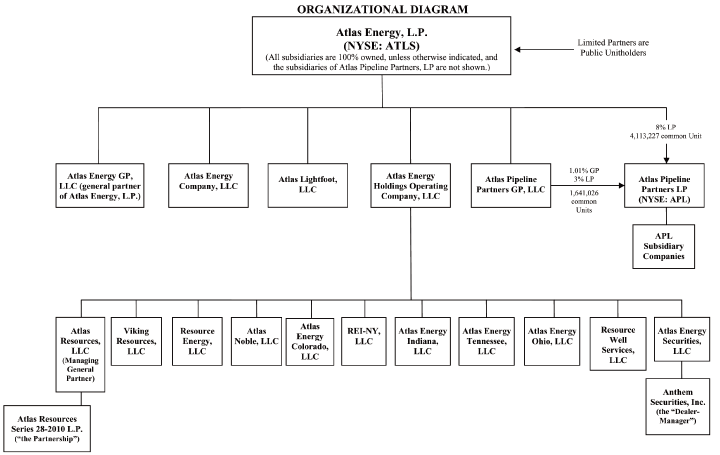
Employees. We have no employees. Instead, we rely on our managing general partner for management
services, and our managing general partner relies on its indirect parent company, Atlas Energy,
L.P. (“Atlas Energy”), and its affiliates for management and administrative services and financing
for capital expenditures. See Item 5 “Directors and Executive Officers,” beginning on page 38, and
the organizational chart on page 44.
Our Offering. Our offering was conducted in reliance on the exemption from registration provided
by Rule 506 under Regulation D and Section 4(2) of the Securities Act. All of our participants
were reasonably believed by our managing general partner to be accredited investors at the time of
sale. We broke escrow and had our first closing on May 14, 2010. When we had our final closing on
September 20, 2010, we had 2,273 investors who purchased our Units (our “participants”). “Units”
means our limited partner Units, our converted limited partner Units and our investor general
partner Units that will automatically be converted by our managing general partner into the
converted limited partner Units once all of our wells are drilled and completed. As of September
20, 2010, we had 7,021 investor general partner Units outstanding, which will automatically be
converted by our managing general partner to limited partner Units after all of our wells are
drilled and completed, and 479 of limited partner Units outstanding. In accordance with the terms
of our offering, 7,312 Units were sold at $20,000 per Unit, and 188 Units were sold at discounted
prices to selling agents and their registered representatives and principals and clients of
registered investment advisors, and investors who bought Units through the officers and directors
of our managing general partner. No Units were sold to our managing general partner, and its
officers, directors and affiliates.
Our participants contributed a total of $149,724,600 in subscription proceeds to us, which we paid
to our managing general partner serving as our operator and general drilling contractor under our
drilling and operating agreement. We used all of our subscription proceeds to drill and complete
wells located primarily in western Pennsylvania, central Indiana, northern Colorado and northern
Michigan. Under our partnership agreement, all of the subscription proceeds of our participants
were used to pay the intangible drilling costs of our wells and a portion of the tangible costs.
“Intangible drilling costs” generally means those costs of drilling and completing a well that are
currently deductible, as compared with lease costs, which must be recovered through the depletion
allowance, and equipment costs, which must be recovered through depreciation deductions. “Tangible
costs” generally means the equipment costs of drilling and completing a well that are not currently
deductible as intangible drilling costs and are not lease costs. Our managing general partner was
required to contribute all of the leases on which our wells are situated, pay and/or contribute
services towards our organization and offering costs up to an amount equal to 15% of our
participants’ subscription proceeds and pay all of our equipment costs to drill and complete our
wells that were not paid with our participants’ subscription proceeds. As of December 31, 2010,
the aggregate amount of these contributions by our managing general partner was $33,909,100. A
tabular presentation of the respective capital contributions to us of the participants and our
managing general partner as of December 31, 2010 is set forth below.
2
Capital Contributions to Us As of 12/31/10 (1)
| |
|
|
|
|
|
Participants |
|
$ |
149,724,600 |
|
|
|
|
|
|
Managing General Partner |
|
$ |
33,909,100 |
(2) |
| |
|
|
| (1) |
|
Our cash distributions are allocated between our managing general partner and our
participants in the same percentages as their respective capital contributions bear to our
total capital contributions, except that our managing general partner receives an
additional 10% of our distributions regardless of the amount of its capital contribution. |
| |
| (2) |
|
Our managing general partner’s capital contributions to us increased from $33,909,100
as of December 31, 2010 to $37,891,600 as of March 31, 2011 (unaudited) and are expected to
increase further as our drilling activities are completed. Currently, our managing general
partner anticipates that its total capital contributions to us eventually will be
approximately $46,632,000. |
Investment Objectives. Our investment objectives are to:
|
|
| |
• |
|
Provide monthly cash distributions to our participants from the wells drilled with
our subscription proceeds until the wells are depleted, with a minimum annual return of
capital of 12% during the first 12-month subordination period, 10% during the next
three 12-month subordination periods, and 8% during the fifth 12-month subordination
period based on $20,000 per Unit regardless of the actual subscription price paid,
beginning when natural gas or oil is being sold from at least 75% of our wells. These
distributions during the 60-month aggregate subordination period are not guaranteed,
but are subject to our managing general partner’s subordination obligation as described
in Item 11 “Description of Registrant’s Securities to be Registered — Distributions
and Subordination,” beginning on page 61. |
|
|
|
|
| |
|
|
Under current conditions, and based in part on the drilling results of the 51.58 net
wells which we drilled in 2010 (approximately 43% of our estimated total of 118.69
net wells to be drilled), we believe that our participants will receive the minimum
aggregate distributions described above each year during this 60-month aggregate
subordination period. See Item 3 “Properties”
beginning on page 34, and the “Notes
to Financial Statements — Note 10” in Item 13 “Financial Statements and
Supplementary Data” beginning on page 89. However, we do not yet know the drilling
results of all of the 67.11 net wells which we prepaid in 2010 (approximately 57% of
our estimated total of 118.69 net wells to be drilled), since we were still in the
process of drilling 35.11 of our net wells on March 31, 2011. Therefore, a
participant should not rely on the results of the wells we drilled in 2010 as being
indicative of the results of the wells drilled in 2011. Also, current conditions,
such as prices for natural gas and our costs for operating our wells, will change
during the 60-month aggregate subordination period. See Item 1A “Risk Factors”
beginning on page 12. |
|
|
3
|
|
| |
• |
|
Obtain federal income tax deductions in 2010 from intangible drilling costs in an
amount guaranteed to equal not less than 85% of each participant’s subscription price
for his or her Units. Not less than 85% of our subscription proceeds must be used to
pay the intangible drilling costs we incur to drill and complete our wells. These
deductions for intangible drilling costs may be used to offset a portion of the
participant’s taxable income subject to any objections by the IRS, each participant’s
individual tax circumstances, and the passive activity rules if the participant
invested in us as a limited partner. For example, if a participant paid $20,000 for a
Unit the investment would produce a 2010 tax deduction of not less than $17,000 per
unit, 85%, against: |
|
|
| |
• |
|
ordinary income, or capital gain in some situations, if the participant
invested as an investor general partner; and |
| |
• |
|
passive income if the participant invested as a limited partner. |
| |
|
|
In the first quarter of 2011, our IRS Schedule K-1’s to our participants reported a
deduction for intangible drilling costs in 2010 in an amount equal to 85% of the
subscription price paid by each participant. However, we do not guarantee the IRS’
treatment of our participants’ deductions for intangible drilling costs. If the IRS
were to decrease the amount of the deduction, or defer part of the deduction to 2011
for wells we prepaid in 2010, for example, our participants would not be entitled to
any reimbursement from us for any increase in taxes owed, penalties or interest or
any other lost tax benefits. |
| |
• |
|
Offset a portion of any gross production income generated by us with tax deductions
from percentage depletion. |
|
|
| |
• |
|
Provide each of our participants with tax deductions, in an aggregate amount
guaranteed to equal up to the remaining 15% of the participant’s initial investment in
us that was used to pay equipment costs of our wells, instead of intangible drilling
costs, through annual depreciation deductions over a seven-year cost recovery period,
subject to: |
|
|
| |
• |
|
a 50% write-off in 2010 for the costs of qualified equipment acquired before
September 8, 2010 and used in wells placed in service for the production of
natural gas production in 2010; or |
| |
• |
|
a 100% write-off in 2010 for the costs of qualified equipment acquired after
September 8, 2010 and used in wells placed in service for the production of
natural gas in either 2010 or 2011. |
Under Section 5.01(a) of our partnership agreement, all of our subscription proceeds that are not
used to pay intangible drilling costs must be used to pay the equipment costs we incur to drill and
complete our wells. For example, if 86% of our subscription proceeds is used to pay intangible
drilling costs, then we guarantee that the remaining 14% of our subscription proceeds will be used
to pay equipment costs.
4
The tax benefits of these depreciation deductions to our participants are subject to any objections
by the IRS, each participant’s individual tax circumstances, and the passive activity rules if the
participant invested as a limited partner or is a converted limited partner. Also, we do not
guarantee the IRS’ treatment of our participants’ depreciation deductions for our equipment costs.
If the IRS were to decrease the amount of the deductions, for example, our participants would not
be entitled to any reimbursement from us for any increase in taxes owed, penalties or interest or
any other lost tax benefits.
Oil and Natural Gas Properties. As of December 31, 2010, we had drilled 51.58 net development
wells, and as of March 31, 2011 we had drilled an additional 32.00 net development wells and had
begun drilling approximately 35.11 more net development wells. Because all of our wells have not
yet been drilled and completed, our investor general partner Units have not yet been converted to
limited partner Units. We will not drill any wells except the wells funded with our subscription
proceeds and our managing general partner’s capital contributions to us as described above. For
further information concerning our natural gas and oil properties, including the status of our
drilling activities, our leasing practices and our reserve and acreage information, see Item 3
“Properties” beginning on page 34. We believe that our ongoing operating and maintenance costs for
our productive wells will be paid through revenues we receive from the sale of our natural gas and
oil production as discussed in Item 2 “Financial
Information” beginning on page 27. Thus, the
subscription proceeds from the offering of our Units in 2010 and our ongoing natural gas and oil
production revenues from our wells will satisfy all of our cash requirements and we will not seek
to raise additional funds from either our participants or new investors.
We pay our managing general partner a monthly well supervision fee of $975 per well per month in
the Marcellus Shale primary area in western Pennsylvania, $1,500 per well per month in the New
Albany Shale primary area in central Indiana, and $600 per well per month in the Antrim Shale
primary area in northern Michigan, for serving as the operator of our wells. This well supervision
fee covers all normal and regularly recurring operating expenses for the production and sale of
natural gas and to a lesser extent oil, such as:
| |
• |
|
well tending, routine maintenance and adjustment; |
| |
• |
|
reading meters, recording production, pumping, maintaining appropriate books and
records; and |
| |
• |
|
preparing reports to us and to government agencies. |
The well supervision fees, however, do not include costs and expenses related to the purchase of
certain equipment, materials, rebuilding of access roads, water hauling, or certain other goods or
services provided by our managing general partner’s affiliates at competitive rates in the area or
by third-parties. In this regard, our managing general partner will determine competitive industry
rates for equipment, supplies and other services by conducting a survey of the interest and/or fees
charged by unaffiliated third-parties engaged in similar businesses in the same geographic areas.
If possible, our managing general partner will contact at least two unaffiliated
third-parties; however, our managing general partner will have sole discretion in determining the
amount to be charged us, subject to the foregoing.
5
Production. All of our wells are expected to produce natural gas, and some of our wells are
currently producing natural gas and to a far lesser extent oil, which are our only products. We do
not plan to sell any of our wells and intend to continue to produce them until they are depleted,
at which time they will be plugged and abandoned. See Item 3 “Properties” beginning on page 34 for
information concerning:
| |
• |
|
our natural gas and oil production quantities; |
| |
• |
|
average sales prices; and |
| |
• |
|
average production costs. |
Sale of Natural Gas and Oil Production. Our managing general partner is responsible for selling
our natural gas and oil production. In the geographic areas where our wells are situated, our
managing general partner is a party to natural gas contracts with various natural gas purchasers,
each of which is paying a different price for our natural gas. Our managing general partner is
also responsible for gathering and transporting the natural gas produced by us to interstate
pipeline systems, local distribution companies, and/or end-users in the area (the “gathering
services”), and we pay our managing general partner a competitive gathering fee for this service.
In providing the gathering services our managing general partner may use gathering systems owned by
its affiliates or independent third-parties.
We will pay a gathering fee directly to our managing general partner at competitive rates for the
gathering services. The gathering fee paid by us to our managing general partner may be increased
from time-to-time by our managing general partner, in its sole discretion, but may not be increased
beyond competitive rates as determined by our managing general partner. Currently, our managing
general partner has determined that the competitive rates in our primary areas are as follows:
| |
• |
|
in the Marcellus Shale primary area, an amount equal to 16% of the gross sales price
received by us for our natural gas, and for this purpose gross sales price means the
price that is actually received, adjusted to take into account proceeds received or
payments made pursuant to hedging arrangements; |
| |
• |
|
in the New Albany Shale (Indiana) primary area, a gathering fee of $0.005 (1/2 of
one cent) per mcf per mile the natural gas is transported, plus a processing fee of
$1.00 per mcf if the natural gas is processed through a processing plant in Indiana in
which an affiliate of our managing general partner owns an interest; and |
| |
• |
|
in the Antrim Shale primary area in Michigan, an average gathering fee of
approximately $.30 per mcf transported. |
6
The payment of a competitive fee to our managing general partner for its gathering services is
subject to the following conditions:
| |
• |
|
If a third-party gathering system is used by us, then our managing general
partner’s gathering fee with respect to our natural gas will be the actual
transportation and compression fees charged by the third-party gathering system and our
managing general partner will pay all of the gathering fee it receives from us to the
third-party gathering the natural gas. |
| |
• |
|
If both a third-party gathering system and a gas gathering system owned by
an affiliate of our managing general partner are used by us, then our managing general
partner will receive an amount equal to a competitive fee as described above for the
natural gas transported by the segment provided by the gathering system owned by an
affiliate of our managing general partner, plus the amount charged by the third-party
gathering system for the natural gas transported by the segment provided by the
third-party. |
Our managing general partner will determine competitive industry rates for its gathering services
by conducting a survey of gathering fees charged by unaffiliated third-parties in the same
geographic areas. If possible, our managing general partner will contact at least two unaffiliated
third-parties; however, our managing general partner will have sole discretion in determining the
amount to be charged us, subject to the foregoing.
Our managing general partner considers a drilling area to be a primary drilling area if 10% or more
of our subscription proceeds are used to drill wells in the area. In this regard, our managing
general partner anticipates that:
| |
• |
|
The natural gas produced from the Marcellus Shale primary area in Pennsylvania will
be sold primarily to UGI Energy Services, Colonial Energy, Inc., South Jersey Resources
Group, ConocoPhillips Company, Dominion Field Services, Inc., EQT Energy LLC, Equitable
Gas Company, Sequent Energy Management, L.P., and NJR Energy Services pursuant to
various contracts. |
| |
• |
|
The natural gas produced from the New Albany Shale primary area in Indiana will be
sold primarily to Atmos Energy pursuant to contracts which end March 31, 2014. |
| |
• |
|
The natural gas produced from the Antrim Shale primary area in Michigan will be sold
primarily to DTE Energy Company, BP Canada, Conoco Phillips, Sequent Energy, Nexen, and
Total Gas & Power pursuant to various contracts or on the spot market. |
All of the natural gas contracts described above are between the natural gas purchaser and our
managing general partner or its affiliates. Either our managing general partner or its affiliates
will receive the sales proceeds from the natural gas purchasers and then distribute the sales
proceeds to us based on the volume of natural gas produced by us. Until the sales proceeds are
distributed to us, they will be subject to the claims of our managing general partner’s or its
affiliates’ creditors.
7
The pricing and delivery arrangements with the vast majority of the natural gas purchasers
described above are tied to the settlement of the New York Mercantile Exchange Commission (“NYMEX”)
monthly futures contracts price, which is reported daily in the Wall Street Journal, with an
additional premium, which is referred to as the basis, paid for natural gas production in the
Appalachian Basin because of the relatively close location of the natural gas in relation to the
natural gas market. These arrangements do not include our natural gas production from the New
Albany Shale primary area in Indiana or the Antrim Shale primary area in Michigan since these areas
are not situated in the Appalachian Basin.
Pricing for natural gas and oil production has been volatile and unpredictable for many years.
Currently, none of our natural gas production is subject to hedging arrangements. Instead, our
production is sold at contract prices in the month produced or at spot market prices. The prices
under most of our gas sales contracts are negotiated on an annual basis and are index-based.
However, to limit our exposure if natural gas prices fall, we have used hedges in the past, and
expect to do so again in the future, to lock in a range of pricing for a significant portion of our
production during the periods covered by the hedges. In this regard, in conjunction with the
“Asset Acquisition” and the “Chevron Merger” described in Item 5 “Directors and Executive Officers
— Managing General Partner,” beginning on page 38, all of the previous derivative contracts
related to the natural gas and oil production of the partnerships sponsored by our managing general
partner, including us, were monetized and we and the other partnerships will share in the total
available hedge gains based on each partnership’s actual production volumes during the period of
the original derivative contracts, some which would have extended into 2014.
With respect to future hedging arrangements, our managing general partner and its affiliates may
enter into financial hedges through contracts such as NYMEX futures and options contracts and
over-the-counter futures contracts through banking counterparties on behalf of us and the other
partnerships sponsored by our managing general partner, including future partnerships. They may
also use physical hedges through their natural gas purchasers as discussed below. These futures
contracts are commitments to purchase or sell natural gas at future dates and generally have
covered one-month periods for up to 60 months in the future. To assure that the financial
instruments will be used solely for hedging price risks and not for speculative purposes, our
managing general partner has established a risk management committee to assure that all financial
trading is done in compliance with our managing general partner’s hedging policies and procedures.
Our managing general partner does not intend to contract for positions that it cannot offset with
actual production. Any physical hedges require firm delivery of natural gas and, therefore, are
considered normal sales of natural gas, rather than hedges, for accounting purposes. Additionally,
we may enter into our own agreements and financial instruments relating to hedging our natural gas
and oil and the pledging of up to 100% of our assets and reserves in connection therewith.
8
The percentages of our natural gas that may hedged in the future through either financial hedges,
physical hedges or not hedged at all will change from time to time in the discretion of our
managing general partner and its affiliates and are not limited. If the hedges are with our
managing general partner or its affiliates, rather than us, it is difficult to project what portion
of these hedges will be allocated to us by our managing general partner because of uncertainty
about the quantity, timing, and delivery locations of natural gas that may be produced by us.
However, the allocations must be based on actual production in accordance with past practice.
Although hedging will provide us some protection against falling prices, these activities also
could reduce the potential benefits of price increases and we could incur liability on the
financial hedges. See Item 1A “Risk Factors — Risks Related to an Investment in Us — Future
Hedging Activities We Anticipate Undertaking May Adversely Affect Our Financial Situation and
Results of Operations” on page 24. We and the other partnerships sponsored by our
managing general partner and its affiliates will be severally liable for our respective allocated
share of the liabilities under any future hedging agreements, but will not be jointly and severally
liable for the entire amount of the liabilities under the hedging agreements.
Crude oil produced from our wells will flow directly into storage tanks where it will be picked up
by the oil company, a common carrier, or pipeline companies acting for the oil company which is
purchasing the crude oil. Unlike natural gas, crude oil does not present any transportation
problem. Our managing general partner anticipates selling any oil produced by our wells to
regional oil refining companies at the prevailing spot market price for Appalachian crude oil in
spot sales.
Subject to our managing general partner’s and its affiliates’ interest in their natural gas
contracts, hedging arrangements, and pipelines and gathering systems, all benefits and liabilities
from marketing and any other relationships affecting the property of our managing general partner
or its affiliates or us must be fairly and equitably apportioned according to the interests of each
in the property, consistent with past practice.
Major Customers. Our natural gas and oil is sold to various purchasers. For the period ended
March 31, 2011, sales to Atmos Energy Marketing, LLC accounted for 87% of our total revenues. For
the period ended December 31, 2010, sales to Atmos Energy Marketing, LLC accounted for 98% of our
total revenues. No other customer accounted for more than 10% of our total revenues for the
periods ended March 31, 2011 and December 31, 2010, respectively. As of March 31, 2011 and
December 31, 2010, only 66% and 39%, respectively, of the total 110.14 net wells we currently
expect to drill and complete were online and producing natural gas. Thus, the percentages of sales
to our customers as set forth above should not be considered to be representative of our sales and
customers after all of our wells are online and producing.
9
Competition. The energy industry is intensely competitive in all of its aspects. Competition
arises not only from numerous domestic and foreign sources of natural gas and oil, but also from
other industries that supply alternative sources of energy. In selling our natural gas and oil,
product availability and price are our principal
means of competition. We may also encounter competition in obtaining drilling and operating
services from third-party providers. Any competition we encounter could delay the drilling and/or
operating of our wells, and thus delay the distribution of our revenues to our participants. While
it is impossible for us to accurately determine our comparative position in the natural gas and oil
industry, we do not consider our operations to be a significant factor in the industry.
Markets. The availability of a ready market for natural gas and oil, and the price obtained,
depend on numerous factors beyond our control as described below in Item 1A “Risk Factors — Risks
Relating to Our Business” beginning on page 13. During fiscal years 2008, 2009, and 2010 our
managing general partner did not experience problems in selling its and its affiliates’ natural gas
and oil, although prices varied significantly during those periods.
Governmental Regulation
Regulation of Production. The production of natural gas and oil is subject to regulation under a
wide range of local, state and federal statutes, rules, orders and regulations, such as
requirements for permits for drilling operations, drilling bonds and reports concerning operations.
Also, each state in which we drill a well has regulations governing conservation matters,
including the regulation of well spacing. The effect of these regulations is to limit the number
of wells, or the locations where we can drill wells, although we can apply for exemptions to the
regulations to reduce the well spacing. The failure to comply with these rules and regulations can
result in substantial penalties. Our competitors in the oil and natural gas industry are subject
to the same regulatory requirements and restrictions that affect our operations.
Regulation of Transportation and Sale of Natural Gas. Governmental agencies regulate the
production and transportation of natural gas. Generally, the regulatory agency in the state where
a producing natural gas well is located supervises production activities and the transportation of
natural gas sold into intrastate markets, and the Federal Energy Regulatory Commission (“FERC”)
regulates the interstate transportation of natural gas.
Natural gas prices have not been regulated since 1993, and the price of natural gas is subject to
the supply and demand for natural gas along with factors such as the natural gas’ BTU content and
where the wells are located. Since 1985 FERC has sought to promote greater competition in natural
gas markets in the United States. Traditionally, natural gas was sold by producers to interstate
pipeline companies that served as wholesalers and resold the natural gas to local distribution
companies for resale to end-users. FERC changed this market structure by requiring interstate
pipeline companies to transport natural gas for third-parties. In 1992 FERC issued Order 636 and a
series of related orders that required pipeline companies to, among other things, separate their
sales services from their transportation services and provide an open access transportation service
that is comparable in quality for all natural gas producers or suppliers. The premise behind FERC
Order 636 was that the interstate pipeline companies had an unfair advantage over other natural gas
producers or suppliers
because they could bundle their sales and transportation services together. FERC Order 636 is
designed to ensure that no natural gas seller has a competitive advantage over another natural gas
seller because it also provides transportation services.
10
In 2000 FERC issued Order 637 and subsequent orders to enhance competition by removing price
ceilings on short-term capacity release transactions. It also enacted other regulatory policies
that were intended to enhance competition in the natural gas market and increase the flexibility of
interstate natural gas transportation. FERC has further required pipeline companies to develop
electronic bulletin boards to provide standardized access to information concerning capacity and
prices.
Crude Oil Regulation. Oil prices are not regulated, and the price is subject to the supply and
demand for oil, along with qualitative factors such as the gravity of the crude oil and sulfur
content differentials.
State Regulation. Each state where we drill a well imposes a comprehensive statutory and
regulatory scheme for natural gas and oil operations, including supervising the production
activities and the transportation of natural gas sold in intrastate markets, which creates
additional financial and operational burdens. For example, in our primary areas our oil
and gas operations are regulated by the Department of Environmental Resources in Pennsylvania,
the Department of Natural Resources in Indiana and the Department of Natural Resources and
Environment in Michigan. Among other things, the regulations involve:
| |
• |
|
new well permit and well registration requirements, procedures, and fees; |
| |
• |
|
landowner notification requirements; |
| |
• |
|
certain bonding or other security measures; |
| |
• |
|
minimum well spacing requirements; |
| |
• |
|
restrictions on well locations and underground gas storage; |
| |
• |
|
certain well site restoration, groundwater protection including water disposal
plans, and safety measures; |
| |
• |
|
discharge permits for drilling operations; |
| |
• |
|
various reporting requirements; and |
| |
• |
|
well plugging standards and procedures. |
Environmental Regulation. Our drilling and producing operations are subject to various federal,
state, and local laws covering the discharge of materials into the environment, or otherwise
relating to the protection of the environment. The Environmental Protection Agency and state and
local agencies will require us to obtain permits and take other measures with respect to:
| |
• |
|
the discharge of pollutants into navigable waters; |
| |
• |
|
disposal of wastewater; and |
| |
| |
• |
|
air pollutant emissions, which may include CO2 emissions from natural gas
and oil wells. |
11
If these requirements or permits are violated, there can be substantial civil and criminal
penalties that will increase if there was willful negligence or misconduct. In addition, we may be
subject to fines, penalties and unlimited liability for cleanup costs under various federal laws
such as the Federal Clean Water Act, the Clean Air Act, the Resource Conservation and Recovery Act,
the Oil Pollution Act of 1990, the Toxic Substance Control Act, and the Comprehensive Environmental
Response, Compensation and Liability Act of 1980 for oil and/or hazardous substance contamination
or other pollution caused by our drilling activities or our wells and our production activities.
Additionally, our liability can extend to pollution that occurred on our leases before we acquired
the leases. Also, each state where we drill a well has either adopted federal standards or
promulgated its own environmental requirements consistent with the federal regulations.
We believe we have complied in all material respects with applicable federal and state regulations
and do not expect that these regulations will have a material adverse impact on our operations.
Although compliance may cause delays in drilling our wells, which we do not anticipate, or increase
our costs, currently we do not believe these costs will be substantial. However, we cannot predict
the ultimate costs of complying with present and future environmental laws and regulations because
these laws and regulations are frequently changed, and ultimately they may have a material impact
on our operations or costs to remain in compliance. Additionally, we cannot obtain insurance to
protect against many types of environmental claims, including remediation costs.
Dismantlement, Restoration, Reclamation and Abandonment Costs. When we determine that a well is no
longer capable of producing natural gas or oil in economic quantities, we must dismantle the well
and restore and reclaim the surrounding area before we can abandon the well. We contract these
operations to independent service providers to which we pay a fee. The contractor will also
salvage the equipment on the well, which we then sell in the used equipment market.
ITEM 1A. RISK FACTORS
Statements made by us that are not strictly historical facts are “forward-looking” statements that
are based on current expectations about our business and assumptions made by our managing general
partner. These statements are subject to risks and uncertainties that exist in our operations and
business environment that could result in actual outcomes and results that are materially different
than those predicted.
12
Risks Relating to Our Business
Natural Gas and Oil Prices are Volatile and a Substantial Decrease in Prices, Particularly Natural
Gas Prices, Would Decrease Our Revenues, Our Cash Distributions and the Value of Our Properties and
Could Reduce Our Managing General Partner’s Ability to Loan Us Funds; Meet Its Ongoing Obligations
to
Indemnify Our Investor General Partners and Purchase Units Under Our Presentment Feature. A
substantial decrease in natural gas and oil prices, particularly natural gas prices, would decrease
our revenues and the value of our natural gas and oil properties. Our future financial condition
and results of operations, and the value of our natural gas and oil properties, will depend on
market prices for natural gas and, to a much lesser extent, oil. Further, if natural gas and oil
prices decrease during the first years of production from our wells, which is when the wells
typically achieve their greatest level of production, there would be a greater adverse effect on
our distributions to our participants than price decreases in later years when the wells have a
lower level of production. Also, our participants’ return level will decrease during our term,
even if there are rising natural gas prices, because of reduced production volumes from our wells.
Prices for natural gas and oil are dictated by supply and demand factors and prices may fluctuate
widely in response to relatively minor changes in the supply of and demand for natural gas or oil,
and market uncertainty. For example, reduced natural gas demand and/or excess natural gas supplies
will result in lower prices. Other factors affecting the price and/or marketing of natural gas and
oil production, which are beyond our control and cannot be accurately predicted, are the following:
| |
• |
|
the cost, proximity, availability, and capacity of pipelines and other
transportation facilities; |
| |
• |
|
the price and availability of other energy sources such as coal, nuclear
energy, solar and wind; |
| |
• |
|
the price and availability of alternative fuels, including when large
consumers of natural gas are able to convert to alternative fuel use systems; |
| |
• |
|
local, state, and federal regulations regarding production, conservation,
water disposal, and transportation; |
| |
• |
|
overall domestic and global economic conditions; |
| |
• |
|
the impact of the U.S. dollar exchange rates on natural gas and oil
prices; |
| |
• |
|
technological advances affecting energy consumption; |
| |
• |
|
domestic and foreign governmental relations, regulations and taxation; |
| |
• |
|
the impact of energy conservation efforts; |
| |
• |
|
the general level of supply and market demand for natural gas and oil on a regional,
national and worldwide basis; |
| |
• |
|
weather conditions and fluctuating seasonal supply and demand for natural
gas and oil because of various factors such as home heating requirements in the winter
months; |
| |
• |
|
economic and political instability, including war or terrorist acts in
natural gas and oil producing countries, including those of the Middle East, Africa and
South America; |
| |
• |
|
the amount of domestic production of natural gas and oil; and |
13
| |
• |
|
the amount and price of imports of natural gas and oil from foreign
sources, including the actions of the members of the Organization of Petroleum
Exporting Countries (“OPEC”), which include production quotas for petroleum products
from time to time with the intent of increasing, maintaining, or decreasing price
levels. |
These factors make it extremely difficult to predict natural gas and oil price movements with any
certainty.
Price decreases would reduce the amount of our cash flow available for distribution to our
participants and could make some of our reserves uneconomic to produce which would reduce our
reserves and cash flow. Additionally, price decreases may cause the lenders under Atlas Energy,
L.P.’s credit facility to reduce its borrowing base because of lower revenues or reserve values,
which would indirectly reduce our managing general partner’s liquidity, and could possibly, require
mandatory loan repayments from our managing general partner if Atlas Energy, L.P. and its other
affiliates called on our managing general partner to do so. This would reduce our managing general
partner’s ability to loan us money or to meet its ongoing partnership obligations, such as
indemnification of our investor general partners for liabilities in excess of their pro rata share
of our assets and insurance proceeds and purchasing Units presented by our participants.
Estimates of Our Natural Gas and Oil Reserves are Based on Many Assumptions that May Prove to be
Inaccurate. Any Material Inaccuracies in these Underlying Assumptions Will Materially Affect the
Quantities and Present Value of Our Reserves. Underground accumulations of natural gas and oil
cannot be measured in an exact way. Natural gas and oil reserve engineering requires subjective
estimates of underground accumulations of natural gas and oil and assumptions concerning future
natural gas prices, production levels and operating and development costs. As a result, estimated
quantities of proved reserves and projections of future production rates and the timing of
development expenditures may prove to be inaccurate as discussed in Item 3 “Properties — Natural
Gas and Oil Reserve Information” beginning on page 35. Any significant variance from these
assumptions by actual figures could greatly affect estimates of reserves, the economically
recoverable quantities of natural gas and oil, the classifications of reserves based on risk of
recovery and estimates of the future net cash flows. Numerous changes over time to the
assumptions on which our reserve estimates are based, as described above, will likely result in the
actual quantities of natural gas and oil we ultimately recover being different from our reserve
estimates.
The present value of future net cash flows from our proved reserves is not necessarily the same as
the current market value of our estimated natural gas reserves. We base the estimated discounted
future net cash flows from our proved reserves on historical prices and costs. However, the actual
future net cash flows we derive from such properties also will be affected by factors such as:
| |
• |
|
actual prices we receive for natural gas; |
| |
• |
|
the amount and timing of actual production; |
14
| |
• |
|
the amount and timing of our capital expenditures; |
| |
• |
|
supply of and demand for natural gas; and |
| |
• |
|
changes in governmental regulations or taxation. |
The timing of both our production and incurrence of expenses in connection with the development and
production of natural gas properties will affect the timing of actual future net cash flows from
proved reserves, and thus their actual present value. In addition, the 10% discount factor we use
when calculating discounted future net cash flows may not be the most appropriate discount factor
based on interest rates in effect from time to time and risks associated with us or the natural gas
and oil industry in general.
Any significant variance in our assumptions could materially affect the quantity and value of our
reserves, the amount of PV-10 and standardized measure, and our financial condition and results of
operations. In addition, our reserves or PV-10 and standardized measure may be revised downward or
upward based upon production history, prevailing natural gas and oil prices and other factors. A
material decline in prices paid for our production can reduce the estimated volumes of our reserves
because the economic life of our wells could end sooner. Similarly, a decline in market prices for
natural gas or oil may reduce our PV-10 and standardized measure.
Our Managing General Partner Has Limited Experience in Drilling Horizontal Wells to the Marcellus
Shale and Horizontal Wells are More Expensive and Difficult to Drill and Complete Than Vertical
Wells. As of March 31, 2011, our managing general partner had participated in drilling and served
as operator on approximately 31 horizontal wells in the Marcellus Shale, which does not include the
12 horizontal Marcellus Shale wells it is drilling on our behalf. In addition, horizontal wells in
the Marcellus Shale are more expensive to drill and complete than vertical wells, because of
increased costs associated with the drilling rigs needed to drill a horizontal well, including
fracing the wells, and casing for the wells. For example, in the Marcellus Shale, a horizontal
well may cost three times the amount of a vertical well and this increased cost to us may not
result in greater recoverable reserves. Also, horizontal wells will be more susceptible to
mechanical problems associated with completing the wells, such as casing collapse and lost
equipment in the wellbore, than vertical wells. Further, fracing the formation in a horizontal
well is more complicated than fracing the same geological formation in a vertical well. Thus,
there is a greater risk of loss of the well or cost overruns associated with horizontal drilling as
compared with vertical drilling.
15
Drilling Our Wells Requires Adequate Sources of Water to Facilitate the Fracturing Process and Our
Production Operations Result in Removing Water from Our Wells that We Must Dispose Of. If We are
Unable to Dispose of the Water We Remove from a Well at a Reasonable Cost and Within Applicable
Environmental Rules, Our Ability to Produce Natural Gas from the Well Could Be Impaired. Our
natural gas wells in the Marcellus Shale primary area use a process called hydraulic fracturing,
which requires large
amounts of water to frac the wells and also results in water discharges that must be treated and
disposed of. Environmental regulations governing the injection, withdrawal, storage and use of
surface water or groundwater necessary for hydraulic fracturing may increase operating costs and
cause delays, interruptions or termination of operations, the extent of which cannot be predicted,
all of which could have an adverse effect on our operations and financial performance. For
example, before we can drill a well to the Marcellus Shale in Pennsylvania using hydraulic
fracturing our well permit application to the Pennsylvania Department of Environmental Protection
(“the Pennsylvania DEP”) must, among other things:
|
|
| |
• |
|
disclose our plans for using casing (e.g. steel pipe) in the well and cementing the
casing in place through all fresh water aquifers before drilling to deeper natural gas
formations in order to protect groundwater from contamination by natural gas or frac
fluid produced from the well; |
|
|
|
|
| |
• |
|
disclose the source and location of the water we will use; |
|
|
|
|
| |
• |
|
identify where wastewater produced from the well will be stored, treated and
disposed of; |
|
|
|
|
| |
• |
|
disclose our plans for any pits to temporarily store water for our drilling
activities, which must be constructed in accordance with the Pennsylvania DEP standards
(e.g. synthetic liners); and |
|
|
|
|
| |
• |
|
submit reports to the Pennsylvania DEP on well completion, waste management, annual
production, and plugging and abandonment. |
|
|
Our ability to remove and dispose of water will affect our production, and the cost of water
treatment and disposal may affect our profitability.
New federal and state environmental regulations, in addition to those discussed above, could be
imposed that would include restrict our ability to conduct hydraulic fracturing or dispose of
water, drilling fluids and other substances associated with the exploration, development and
production of natural gas and oil. In this regard, the U.S. Environmental Protection Agency
(“EPA”) is studying the potential impact of hydraulic fracturing on drinking water, however, the
initial results of this study are not expected by the EPA until late 2012, which will be after all
of our drilling activities will be completed.
Drilling Wells is Highly Speculative and Some of Our Wells Are Nonproductive or May Be Productive,
But Fail to Return the Costs of Drilling and Operating Them. The amount of recoverable natural gas
and oil reserves may vary significantly from well to well. We have drilled some wells that are
nonproductive (i.e. “dry holes”), and we may drill more nonproductive wells or wells that
may be profitable on an operating basis, but do not produce sufficient net revenues to return a
profit after drilling, operating and other costs are taken into account. The geologic data and
technologies available do not allow us to know conclusively before drilling a well whether or not
natural gas or oil is present or can be produced economically.
16
The cost of drilling, completing and operating a well is often uncertain. For example, the
increase in natural gas and oil prices over the last several years has increased the demand for
drilling rigs and other related equipment,
and the costs of drilling and completing natural gas and oil wells also have increased. This has
increased our well costs since our wells are drilled by our managing general partner, serving as
our general drilling contractor, on a modified cost plus basis, and are not drilled on a turnkey
basis for a fixed price that would shift the risk of cost overruns to our managing general partner
as drilling contractor. Thus, any cost overruns in drilling and completing our wells could reduce
or delay distributions to our participants.
The Drilling of Some of Our Wells Could Be Curtailed, Delayed or Cancelled If Unexpected Events
Occur. Some of our drilling operations may be curtailed, delayed or cancelled as a result of many
factors, including:
| |
• |
|
environmental or other regulatory concerns; |
| |
• |
|
costs of, or shortages or delays in the availability of, oil field services and
equipment; |
| |
• |
|
unexpected drilling conditions; |
| |
• |
|
unexpected geological conditions; |
| |
• |
|
adverse weather conditions; |
| |
• |
|
equipment failures or accidents; |
| |
• |
|
limitations on or disruptions in gathering or transmission capacity; |
| |
• |
|
environmental accidents such as gas leaks, ruptures or discharges of toxic gases,
brine or well fluids into the environment or oil leaks, including groundwater
contamination; |
| |
• |
|
fires, blowouts, craterings and explosions; and |
| |
• |
|
uncontrollable flows of natural gas or well fluids. |
As
discussed in Item 3 “Properties,” beginning on page 34, all of our wells are not yet completed
and online. Any one or more of the factors discussed above could reduce or delay our receipt of a
portion, which could be significant, of our natural gas and oil production revenues, thereby
reducing or delaying our revenues and our distributions to our participants. In addition, any of
these events can cause substantial losses, including personal injury or loss of life, damage to or
destruction of property, natural resources and equipment, pollution, environmental contamination,
loss of wells and regulatory penalties.
Although we maintain insurance against various losses and liabilities arising from our operations,
insurance against all operational risks will not be available to us. Additionally, we may elect
not to obtain insurance if we believe that the cost of available insurance is excessive relative to
the perceived risks presented. Losses could, therefore, occur for uninsurable or uninsured risks
or in amounts in excess of existing insurance coverage. The occurrence of an event that is not
fully covered by insurance could reduce our results of operations.
17
If Third-Parties Participating in Drilling Some of Our Wells Fail to Pay Their Share of the Well
Costs, We Would Have to Pay Those Costs in Order to Get the Wells Drilled, and If We Are Not
Reimbursed the Increased Costs Would Reduce Our Cash Flow and Possibly Could Reduce the Number of
Wells We Can
Drill. Third-parties have participated with us in drilling some of our wells. Financial risks
exist when the cost of drilling, equipping, completing, and operating wells is shared by more than
one person. If we pay our share of the costs, but the other interest owner does not pay its share
of the costs, then we would have to pay the costs of the defaulting party. In this event, we would
receive the defaulting party’s revenues from the well, if any, under penalty arrangements set forth
in the operating agreement, which may, or may not, be sufficient to cover the additional costs we
paid. If it is insufficient to cover the additional costs, the increased costs would reduce our
cash flow and the number of wells we can drill unless we borrow funds to cover the additional costs
or the costs of drilling our other wells is less than expected and those excess funds are used to
pay the additional costs.
Risks Related to an Investment In Us
An Investment in Us Must be for the Long-Term Because the Units Are Illiquid and Not Readily
Transferable. If you invest in us, then you must assume the risks of an illiquid investment. The
transferability of the Units is limited by the securities laws, the tax laws, and the partnership
agreement. The Units generally cannot be liquidated since there is no readily available market for
the sale of the Units. Further, we do not intend to list our Units on any exchange.
Also, a sale of your Units could create adverse tax and economic consequences for you. The sale or
exchange of all or part of your Units held for more than 12 months generally will result in a
recognition of long-term capital gain or loss. However, previous deductions for depreciation,
depletion and intangible drilling costs may be recaptured as ordinary income rather than capital
gain regardless of how long you have owned your Units. Also, your pro rata share of our
liabilities, if any, as of the date of the sale or exchange of your Units must be included in the
amount realized by you. Thus, the gain recognized by you may result in a tax liability greater
than the cash proceeds, if any, received by you from the sale or other disposition of your Units,
if permitted under the partnership agreement.
Our Managing General Partner’s Management Obligations to Us Are Not Exclusive, and if It Does Not
Devote the Necessary Time to Our Management There Could Be Delays in Providing Timely Reports and
Distributions to Our Participants, and Our Managing General Partner, Serving as Operator of Our
Wells, May Not Supervise the Wells Closely Enough. We do not have any officers, directors or
employees. Instead, we rely totally on our managing general partner and its affiliates for our
management. Our managing general partner is required to devote to us the time and attention that
it considers necessary for the proper management of our activities. However, our managing general
partner and its affiliates currently are, and will continue to be, engaged in other natural gas and
oil activities, including other partnerships and unrelated business ventures for their own account
or for the account of others, during our term. This creates a continuing conflict of interest in
allocating management time, services, and other activities among us and its other activities. If
our managing general partner does not devote the necessary time to our management, there could be
delays in providing timely annual and semi-annual reports, tax information and cash distributions
to our participants. Also, if our managing
general partner, serving as the operator of our wells, does not supervise the wells closely enough,
for example, there could be delays in undertaking remedial operations on a well, if necessary to
increase the production of natural gas from the well.
18
Current Conditions May Change and Reduce Our Proved Reserves, Which Could Reduce Our Revenues. A
participant will be able to recover his investment in us only through our distribution of our net
sales proceeds from the production of natural gas and oil from our productive wells. The quantity
of natural gas and oil in a well, which is referred to as its reserves, decreases over time as the
natural gas and oil is produced until the well is no longer economical to operate. Our proved
reserves will decline as they are produced from our wells, and once all of our wells are online our
distributions to our participants generally will decrease each year until our wells are depleted.
Our proved reserves at December 31, 2010 from the wells we drilled, completed and placed online for
production in 2010 are set forth in Item 3 “Properties — Natural Gas and Oil Reserve Information”
beginning on page 35. However, there is an element of uncertainty in all estimates of proved
reserves, and current conditions, such as natural gas and oil prices and the costs of operating our
wells and transporting our natural gas, will change in the future and could reduce the amount of
our current proved reserves. Also, our estimated proved reserves and revenues from the sale of
our natural gas and oil production once all of our wells have been drilled and placed online for
production will vary significantly from our expectations associated with the estimated proved
reserves of only the wells we drilled, completed and placed online for production in 2010 as
presented in Item 3 “Properties — Natural Gas and Oil
Reserve Information” beginning on page 35.
We base our estimates of proved natural gas and oil reserves and future net revenues from those
reserves on various assumptions, including those required by the SEC, such as natural gas and oil
prices, taxes, development expenses, capital expenses, operating expenses and availability of
funds. Any significant variance in the future in these assumptions based on actual production,
natural gas and oil prices, taxes, development expenses, operating expenses, availability of funds,
would materially affect the estimated quantity of our reserves as discussed in Item 3 “Properties”
beginning on page 34.
Our properties also may be susceptible to hydrocarbon drainage from wells on adjacent properties in
which we do not have an interest. In addition, our proved reserves may be revised downward in the
future based on the following:
| |
• |
|
the actual production history of our wells; |
| |
• |
|
results of future exploration and development in the area; |
| |
• |
|
decreases in natural gas and oil prices; |
| |
• |
|
governmental regulation; and |
| |
• |
|
other changes in current conditions, many of which are beyond our control. |
19
Government Regulation of the Oil and Natural Gas Industry is Stringent and Could Cause Us to Incur
Substantial Unanticipated Costs for Regulatory Compliance, Environmental Remediation of Our Well
Sites (Which May Not Be Fully Insured) and Penalties, and Could Delay or Limit Our Drilling
Operations. We are subject to complex laws that can affect the cost, manner or feasibility of
doing business. Exploration, development, production and sales of natural gas and oil are subject
to extensive federal, state and local regulations. We discuss our regulatory environment in more
detail in Item 1 “Business — Governmental Regulation” beginning on page 10. We may be required to
make large expenditures to comply with these regulations. Failure to comply with these regulations
may result in the suspension or termination of our operations and subject us to administrative,
civil and criminal penalties. Also, governmental regulations could change in ways that
substantially increase our costs, thereby reducing our return on invested capital, revenues and net
income.
In addition, our operations may cause us to incur substantial liabilities to comply with
environmental laws and regulations. Our natural gas and oil operations are subject to stringent
federal, state and local laws and regulations relating to the release or disposal of materials into
the environment or otherwise relating to environmental protection. These laws and regulations:
| |
• |
|
require the acquisition of a permit before drilling begins; |
| |
• |
|
restrict the types, quantities, and concentration of substances that can be released
into the environment in connection with drilling and production activities; |
| |
• |
|
limit or prohibit drilling activities on certain lands lying within wilderness,
wetlands, and other protected areas; and |
| |
• |
|
impose substantial liabilities for pollution resulting from our operations. |
These laws include, for example:
| |
• |
|
the federal Clean Air Act and comparable state laws and regulations that impose
obligations related to air emissions; |
| |
• |
|
the federal Clean Water Act and comparable state laws and regulations that impose
obligations related to discharges of pollutants into regulated bodies of water; |
| |
• |
|
the Resource Conservation and Recovery Act (“RCRA”) and comparable state laws that
impose requirements for the handling and disposal of waste, including waste water
produced from our wells; and |
| |
• |
|
the Comprehensive Environmental Response, Compensation, and Liability Act (“CERCLA”)
and comparable state laws that regulate the cleanup of hazardous substances produced
from our wells. |
Failure to comply with these laws and regulations may result in the following:
| |
• |
|
assessment of administrative, civil, and criminal penalties; |
20
| |
• |
|
incurrence of investigatory or remedial obligations; or |
| |
• |
|
imposition of injunctive relief. |
Changes in environmental laws and regulations occur frequently, and any changes that result in more
stringent or costly waste handling, storage, transporting, disposal or cleanup requirements could
require us to make significant expenditures to maintain compliance or could restrict our methods or
times of operation. Under these environmental laws and regulations, we could be held strictly
liable for the removal or remediation of previously released materials or property contamination
regardless of whether we were responsible for the release or if our operations were standard in the
industry at the time they were performed. Pollution and environmental risks generally are not
fully insurable. The occurrence of an event that is not covered, or not fully covered, by
insurance could reduce our revenues and the value of our assets.
Our Natural Gas and Oil Activities Are Subject to Drilling and Operating Hazards Which Could Result
in Substantial Losses to Us. Well blowouts, cratering, explosions, uncontrollable flows of natural
gas, oil or well fluids, fires, formations with abnormal pressures, pipeline ruptures or spills,
pollution, releases of toxic gas and other environmental hazards and risks are inherent drilling
and operating hazards for us. The occurrence of any of those hazards could result in substantial
losses to us, including liabilities to third-parties or governmental entities for damages resulting
from the occurrence of any of those hazards and substantial investigation, litigation and
remediation costs.
Our Total Annual Cash Distributions During Our First Five Years May be Less Than $10,000 Per Unit,
Even With Subordination. If our participants’ cash distributions from us are less than 12% of
capital ($2,400 per $20,000 unit) in the first 12-month subordination period, 10% of capital
($2,000 per $20,000 unit) in each of the next three 12- month subordination periods, and 8% of
capital ($1,600 per $20,000 unit) in the fifth 12-month subordination period based on a $20,000
Unit regardless of the actual price paid) for the 60-month aggregate subordination period beginning
when natural gas or oil is being sold from at least 75% of our wells, then our managing general
partner has agreed to subordinate a portion of its share of our net production revenues. However,
if our wells produce only small natural gas and oil volumes, and/or natural gas and oil prices
decrease, then even with subordination our participants may not receive the return of capital in
each of the five 12-month subordination periods described above. Also, at any time during the
60-month aggregate subordination period our managing general partner is entitled to an additional
share of our revenues to recoup previous subordination distributions to the extent our
participants’ cash distributions from us would exceed the return of capital described above. A
more detailed discussion of our managing general partner’s subordination obligation is set forth in
Item 11 “Description of Registrant’s Securities to be Registered — Distributions and
Subordination” beginning on page 61.
21
Our Limited Operating History Creates Greater Uncertainty Regarding Our Ability to Operate
Profitably. Our limited history of operating our wells may not indicate the results that we may
achieve in the future. Our success depends on generating sufficient revenues by producing
sufficient quantities of natural gas and oil from our wells and then marketing that natural gas and
oil at sufficient prices to pay the operating costs of our wells and our administrative costs of
conducting business as a partnership, and still provide a reasonable rate of return on our
participants’ investment in us. If we are unable to pay our costs, then we may need to:
| |
• |
|
borrow funds from our managing general partner, which is not contractually obligated
to make any loans to us; |
| |
• |
|
shut-in or curtail production from some of our wells; or |
| |
• |
|
attempt to sell some of our wells, which we may not be able to do on terms that are
acceptable to us. |
Also, the events set forth below could decrease our revenues from our wells and/or increase our
expenses of operating our wells:
| |
• |
|
decreases in the price of natural gas and oil, which are volatile; |
| |
• |
|
changes in the oil and gas industry, including changes in environmental
regulations, which could increase our costs of operating our wells in compliance with
any new environmental regulations; |
| |
• |
|
an increase in third-party costs for equipment or services, or an increase
in gathering and compression fees for transporting our natural gas production; and |
| |
• |
|
problems with one or more of our wells, which could require repairing or
performing other remedial work on a well or providing additional equipment for the
well. |
Competition May Reduce Our Revenues from the Sale of Our Natural Gas. Competition arises from
numerous domestic and foreign sources of natural gas and oil, including other natural gas producers
and marketers in the Appalachian Basin, Indiana, and Michigan as well as competition from other
industries that supply alternative sources of energy. Competition will make it more difficult to
market our natural gas. Product availability and price are the principal means of competition in
selling natural gas and oil. Many of our competitors possess greater financial or other resources
than we do, which may enable them to offer their natural gas to natural gas purchasers on terms,
such as lower prices or a greater volume of natural gas that can be delivered to the purchaser that
we cannot match. Also, other energy sources such as coal may be available to the purchasers at a
lower price. As a result, we may have to seek other natural gas purchasers and we may receive
lower prices for our natural gas and incur higher transportation and compression fees if we sell
our natural gas to these other natural gas purchasers. In this event, our revenues from the sale
of our natural gas would be reduced.
22
We May Have to Replace Our Natural Gas Purchasers and Receive a Lower Price for Our Natural Gas.
We will depend on a limited number of natural gas purchasers to purchase the majority of our
natural gas production. For example, for the periods ended December 31, 2010 and March 31, 2011,
sales to Atmos Energy
Marketing, LLC accounted for 98% and 87%, respectively, of our total revenues. Further, we will
not be guaranteed a specific natural gas price, unless we engage in hedging in the future. Thus,
if our current purchasers were to pay a lower price for our natural gas in the future, our revenues
would decrease. Also, if our current purchasers began buying a reduced percentage of our natural
gas, or stopped buying any of our natural gas, the sale of our natural gas would be delayed until
we found other purchasers, and the substitute purchasers we found may pay lower prices for our
natural gas, which would reduce our revenues.
We Could Incur Delays in Receiving Payment, or Substantial Losses if Payment is Not Made, for
Natural Gas We Previously Delivered to a Purchaser, Which Could Delay or Reduce Our Revenues and
Cash Distributions. There is a credit risk associated with a natural gas purchaser’s ability to
pay. We may not be paid or may experience delays in receiving payment for natural gas that has
already been delivered. In this event, our revenues and cash distributions to our participants
also would be delayed or reduced. In accordance with industry practice, we typically will deliver
natural gas to a purchaser for a period of up to 60 to 90 days before we receive payment. Thus, it
is possible that we may not be paid for natural gas that already has been delivered if the natural
gas purchaser fails to pay for any reason, including bankruptcy. This ongoing credit risk also may
delay or interrupt the sale of our natural gas.
We Intend to Produce Natural Gas and/or Oil from Our Wells Until They Are Depleted, Regardless of
Any Changes in Current Conditions, Which Could Result in Lower Returns to Our Participants as
Compared With Other Types of Investments Which Can Adapt to Future Changes Affecting Their
Portfolios. Our natural gas and oil properties are relatively illiquid because there is no public
market for working interests in natural gas and oil wells. In addition, one of our investment
objectives is to continue to produce natural gas and oil from our wells until the wells are
depleted. Thus, unlike mutual funds, for example, which can vary their portfolios in response to
changes in future conditions, we do not intend, and in all likelihood we would be unable, to vary
our portfolio of wells in response to future changes in economic and other conditions such as
decreases or increases in natural gas or oil prices, or increased operating costs of our wells.
Since Our Managing General Partner Is Not Contractually Obligated to Loan Funds to Us, We Could
Have to Curtail Operations or Sell Properties if We Need Additional Funds and Our Managing General
Partner Does Not Make a Loan to Us. Our revenues from the sale of our natural gas and oil
production may be insufficient to pay all of our ongoing expenses, such as our operating and
maintenance costs for our productive wells or our costs associated with repairing or performing
other remedial work on a well. If this were to occur, we expect that we would borrow the necessary
funds from our managing general partner or its affiliates, although they are not contractually
committed to make a loan. Also, under our partnership agreement the amount we may borrow may not
at any time exceed 5% of our total subscriptions and no borrowings are permitted from
third-parties. If, for any reason, our managing general partner did not loan us the funds needed
to repair or perform
other remedial work on a well, then we might have to curtail operations on the well or attempt to
sell the well, although we may not be able to do so on terms that are acceptable to us.
23
Future Hedging Activities We Anticipate Undertaking May Adversely Affect Our Financial Situation
and Results of Operations. Because the majority of our proved reserves are currently natural gas
reserves, we are more susceptible to movements in natural gas prices. Although currently none of
our natural gas is hedged to protect against a decrease in natural gas prices, we expect to engage
in hedging activities in the future, as we have done in the past, to help protect us if natural gas
prices fall in the future. However, our future hedging activities could reduce the potential
benefits of price increases and we could incur liability on financial hedges. For example, we
would be exposed to the risk of a financial loss if any of the following occurred:
| |
• |
|
our production is substantially less than expected; |
| |
• |
|
the counterparties to the futures contracts fail to perform under the
contracts; or |
| |
• |
|
there is a sudden, unexpected event materially impacting natural gas
prices. |
Increases in Prices for Natural Gas and Oil Could Result in Non-Cash Balance Sheet Reductions Due
to the Accounting Treatment of Derivative Contracts We Expect to Enter Into in the Future. In
conjunction with the “Asset Acquisition” and “Chevron Merger” described in Item 5 “Directors and
Executive Officers — Managing General Partner,” beginning on page 38, Atlas Energy, Inc. monetized
all of its derivative contracts related to natural gas and oil production. We and the other
partnerships sponsored by our managing general partner, including future partnerships, will share
in the total available hedge gains based on each partnership’s actual production volumes during the
period of the original derivative contracts, some of which extended into 2014. In addition, we
anticipate that in the future we will enter into natural gas derivative contracts, either through
Atlas Energy or an affiliate or directly for our own account, and we will account for these
derivative contracts by applying the provisions of Accounting Standards Codification 815,
“Derivatives and Hedging.” Due to the mark-to-market accounting treatment for these contracts, we
could recognize incremental hedge liabilities between reporting periods resulting from increases in
reference prices for natural gas and oil, which could result in us recognizing a non-cash loss in
our accumulated other comprehensive income (loss) and a consequent non-cash decrease in our
partners’ equity between reporting periods. Any such decrease could be substantial.
A Decrease in Natural Gas Prices Could Subject Our and Our Managing General Partner’s Oil and Gas
Properties to an Impairment Loss under Generally Accepted Accounting Principles. Generally
accepted accounting principles require oil and gas properties and other long-lived assets to be
reviewed for impairment whenever events or changes in circumstances indicate that their carrying
amounts may not be recoverable. Long-lived assets are reviewed for potential impairments at the
lowest levels for which there are identifiable cash flows that are largely independent of other
groups of assets. We and our managing general partner will test our respective oil and gas
properties on a field-by-field basis by determining if the historical cost of proved properties
less the applicable accumulated depletion, depreciation and amortization and abandonment is less
than the estimated expected undiscounted
24
future cash flows. The expected future cash flows are estimated
based on our or our managing general partner’s own economic interests and our respective plans to
continue to produce and develop proved reserves. Expected future cash flow from the sale of
production of reserves is calculated based on estimated future prices. We and our managing general
partner estimate prices based on current contracts in place at the impairment testing date,
adjusted for basis differentials and market related information, including published futures
prices. The estimated future level of production is based on assumptions surrounding future levels
of prices and costs, field decline rates, market demand and supply, and the economic and regulatory
climates. Accordingly, declines in the price of natural gas have caused the carrying values of
properties in many of our managing general partner’s previous partnerships to exceed the expected
future cash flow. Future declines in the price of natural gas may cause the carrying value of our,
our managing general partner’s or its other partnerships’ oil and gas properties to exceed the
expected future cash flows, and require an impairment loss to be recognized.
Federal Income Tax Risks.
Changes in the Law May Reduce Our Participants’ Tax Benefits From an Investment in Us. Our
participants’ tax benefits from their investment in us may be affected by changes in the tax laws.
For example, President Obama’s administration has proposed, among other tax changes, the repeal of
certain oil and gas tax benefits, beginning in 2012, including the repeal of the percentage
depletion allowance. This proposal may or may not be enacted into law. The repeal of the
percentage depletion allowance, if it happens, however, would result in a decrease in our
participants’ future tax benefits from their investment in us.
Our Participants’ Deduction for Intangible Drilling Costs May Be Limited for Purposes of the
Alternative Minimum Tax. Under current tax law, our participants’ alternative minimum taxable
income in 2010 cannot be reduced by more than 40% by their respective shares of our deduction for
intangible drilling costs without creating a tax preference item under the alternative minimum tax
rules.
Our Limited Partners Need Passive Income to Use Their Deduction for Intangible Drilling Costs. If
a participant invested in us as a limited partner (except as discussed below), his or her share of
our deduction for intangible drilling costs in 2010 will be a passive loss that cannot be used to
offset “active” income, such as salary and bonuses, or portfolio income, such as dividends and
interest income. Thus, a limited partner may not have enough passive income from us or net passive
income from his or her other passive activities, if any, in 2010 to offset a portion or all of the
limited partner’s passive deduction for intangible drilling costs in 2010. However, any unused
passive loss from intangible drilling costs may be carried forward indefinitely to offset passive
income in subsequent taxable years. Also, except as described below, the passive activity
limitations do not apply to a limited partner that is a C corporation which:
| |
• |
|
is not a personal service corporation or a closely held corporation; |
| |
• |
|
is a personal service corporation in which employee-owners hold 10% (by value) or
less of the stock, but is not a closely held corporation; or |
| |
• |
|
is a closely held corporation (i.e., five or fewer individuals own more than
50% (by value) of the stock), but is not a personal service corporation in which
employee-owners own more than 10% (by value) of the stock, in which case passive losses
may be used to offset net active income (calculated without regard to passive activity
income and losses or portfolio income and losses). |
25
Our Participants May Owe Taxes in Excess of Their Cash Distributions from Us. Our participants may
become subject to income tax liability for their respective shares of our income in any taxable
year in an amount that is greater than the cash they receive from us in that taxable year. For
example:
| |
• |
|
if we borrow money, our participants’ share of our revenues used to pay
principal on the loan will be included in their share of our income and will not be
deductible; |
| |
• |
|
income from sales of natural gas and oil may be included in our
participants’ income from us in one tax year, even though payment is not actually
received by us and, thus, cannot be distributed to our participants until the next tax
year; |
| |
• |
|
if there is a deficit in a participant’s capital account, we may allocate
income or gain to the participant even though the participant does not receive a
corresponding distribution of our revenues; |
| |
• |
|
our revenues may be expended by our managing general partner for
nondeductible costs or retained in us to establish a reserve for future estimated
costs, including a reserve for the estimated costs of eventually plugging and
abandoning our wells, which will reduce our participants’ cash distributions from us
without a corresponding tax deduction; and |
| |
• |
|
the taxable disposition of our property or our participants’ Units may
result in income tax liability to our participants in excess of the cash they receive
from the transaction. |
Investment Interest Deductions of Investor General Partners May Be Limited. If a participant
invested in us as an investor general partner, his or her share of our deduction for intangible
drilling costs in 2010 will reduce the participant’s investment income and may limit the amount of
the participant’s deductible investment interest expense, if any.
Our Participants’ Tax Benefits from an Investment in Us Are Not Contractually Protected. An
investment in us does not give our participants any contractual protection against the possibility
that part or all of the intended tax benefits of their investment will be disallowed by the IRS.
No one provides any insurance, tax indemnity or similar agreement for the tax treatment of our
participants’ investment in us. Our participants have no right to rescind their investment in us
or to receive a refund of any of their investment in us if a portion or all of the intended tax
consequences of their investment in us is ultimately disallowed by the IRS or the courts. Also,
none of the fees paid by us to our managing general partner, its affiliates or independent
third-parties (including special counsel which issued the tax opinion letter) are refundable or
contingent on whether the intended tax consequences of their investment in us are ultimately
sustained if challenged by the IRS.
26
An IRS Audit of Us May Result in an IRS Audit of the Personal Federal Income Tax Returns of Our
Participants. The IRS may audit our annual federal information income tax returns, particularly
since our participants will be eligible to claim a deduction for intangible drilling costs in 2010.
If we are audited, the IRS also may audit the personal federal income tax returns of a portion or
all of our participants, including prior years’ returns and items that are unrelated to us.
Our Deductions May be Challenged by the IRS. If the IRS audits us, it may challenge the amount of
our deductions and the taxable year in which the deductions were claimed, including the deductions
for intangible drilling costs and depreciation. Any adjustments made by the IRS to our federal
information income tax returns could lead to adjustments on the personal federal income tax returns
of our participants and could reduce the amount of their deductions from us in 2010 and subsequent
tax years. The IRS also could seek to recharacterize a portion of our intangible drilling costs
for drilling and completing our wells as some other type of expense, such as lease costs or
equipment costs, which would reduce or defer our participants’ share of our deductions for those
costs.
|
|
|
| ITEM 2. |
|
FINANCIAL INFORMATION. |
Selected Financial Data. The following table sets forth selected financial data for the period
ended December 31, 2010, that we derived from our financial statements, which were audited by Grant
Thornton LLP, independent registered public accountants, and are included in this Form 10.
| |
|
|
|
|
| |
|
For the period April 1, 2010 |
|
| |
|
(commencement of operations) |
|
| |
|
through December 31, 2010 |
|
Income statement data: |
|
|
|
|
Revenues: |
|
|
|
|
Gas and oil production |
|
$ |
2,159,900 |
|
|
|
|
|
Total revenues |
|
$ |
2,159,900 |
|
|
|
|
|
Costs and expenses: |
|
|
|
|
Gas and oil production |
|
$ |
1,000,600 |
|
Dry hole costs |
|
|
1,279,000 |
|
General and administration |
|
|
40,500 |
|
Depletion |
|
|
1,549,400 |
|
|
|
|
|
Total costs and expenses |
|
$ |
3,869,500 |
|
|
|
|
|
Net loss |
|
|
(1,709,600 |
) |
|
|
|
|
Basic and diluted net loss per limited partnership unit |
|
$ |
(205 |
) |
|
|
|
|
27
| |
|
|
|
|
| |
|
For the period April 1, 2010 |
|
| |
|
(commencement of operations) |
|
| |
|
through December 31, 2010 |
|
Operating data: |
|
|
|
|
Net annual production volumes: |
|
|
|
|
Natural gas (mmcf) (1) |
|
|
457,100 |
|
Oil (mbbls) |
|
|
— |
|
|
|
|
|
Total (mmcfs) |
|
|
457,100 |
|
|
|
|
|
Average sales price: |
|
|
|
|
Natural gas (per mcf) |
|
$ |
4.72 |
|
Oil (per bbl) |
|
$ |
— |
|
Other financial information: |
|
|
|
|
Net cash used in operating activities |
|
$ |
— |
|
Capital expenditures |
|
$ |
149,724,600 |
|
EBITDA (2) |
|
$ |
(160,200 |
) |
| |
| |
|
December 31, 2010 |
|
Balance sheet data: |
|
|
|
|
Total assets |
|
$ |
170,091,100 |
|
|
|
|
|
Total liabilities |
|
$ |
1,609,300 |
|
|
|
|
|
Partners’ capital |
|
$ |
168,481,800 |
|
|
|
|
|
| |
|
|
| (1) |
|
Excludes sales of residual gas and sales to landowners. |
| |
| (2) |
|
We define EBITDA as earnings before interest, taxes, depreciation, depletion and
amortization. EBITDA is not a measure of performance calculated in accordance with accounting
principles generally accepted in the United States of America or GAAP. Although not
prescribed under GAAP, we believe the presentation of EBITDA is relevant and useful because it
helps our participants to understand our operating performance and makes it easier to compare
our results with other companies that have different financing and capital structures or tax
rates. EBITDA should not be considered in isolation from, or as a substitute for, our net
income as an indicator of operating performance or cash flows from operating activities as a
measure of liquidity. EBITDA, as we calculate it, may not be comparable to EBITDA measures
reported by other companies. In addition, EBITDA does not represent funds available for
discretionary use. The following reconciles EBITDA to our income from continuing operations
for the periods indicated. |
| |
|
|
|
|
| |
|
For the period April 1, 2010 |
|
| |
|
(commencement of operations) |
|
| |
|
through December 31, 2010 |
|
Loss from continuing operations |
|
$ |
(1,709,600 |
) |
Plus depletion |
|
|
1,549,400 |
|
|
|
|
|
EBITDA |
|
$ |
(160,200 |
) |
|
|
|
|
Forward-Looking Statements. When used in this Form 10, the words “believes,” “anticipates,”
“expects” and similar expressions are intended to identify forward-looking statements. These
statements are subject to certain risks and uncertainties more particularly described in Item 1A
“Risk Factors” beginning on page 12, of this Form 10. These risks and uncertainties could cause
our actual results to differ materially from those that we anticipate. Readers are cautioned not
to place undue reliance on these forward-looking statements, which speak only as of the date of
this Form 10. We undertake no obligation to publicly release the results of any revisions to
forward-looking statements that we may make to reflect events or circumstances after the date of
this Form 10 or to reflect the occurrence of unanticipated events.
28
This
Item 2 “Financial Information” section beginning on page 27, should be read in conjunction
with Item 13 “Financial Statements and Supplementary Data — Notes to Financial Statements,”
beginning on page 77.
Overview. The following discussion provides information to assist in understanding our financial
condition and result of operations. We have drilled and currently operate wells located in
Pennsylvania, Indiana, Michigan, and Colorado and are currently drilling additional development
wells in the same primary areas. Our operating cash flows are generated from our wells, which
produce primarily natural gas, but also some oil. Our produced natural gas and oil is then
delivered to market through affiliated or third-party gas gathering systems. Our ongoing operating
and maintenance costs have been and are expected to be fulfilled through revenues from the sale of
our natural gas and oil production. We pay our managing general partner, as operator, a monthly
well supervision fee, which covers all normal and regularly recurring operating expenses for the
production and sale of natural gas and oil such as:
|
|
| |
• |
|
well tending, routine maintenance and adjustment; |
|
|
|
|
| |
• |
|
reading meters, recording production, pumping, maintaining appropriate books and
records; and |
|
|
|
|
| |
• |
|
preparation of reports for us and government agencies. |
|
|
The well supervision fees, however, do not include costs and expenses related to the purchase of
certain equipment, materials and brine disposal. If these expenses are incurred, we pay cost for
third-party services, materials, and a competitive charge for services performed directly by our
managing general partner or its affiliates. Also, beginning one year after each of our wells has
been placed into production our managing general partner, as operator, may retain $200 per month,
per well to cover the estimated future plugging and abandonment costs of the well. As of March 31,
2011, our managing general partner had not withheld any funds for this purpose.
Our managing general partner intends to produce our wells until they are depleted or become
uneconomical to produce, at which time they will be plugged and abandoned or sold. No other wells
will be drilled and no additional funds will be required for drilling.
Markets and Competition. The availability of a ready market for natural gas and oil produced by
us, and the price obtained, depends on numerous factors beyond our control, including the extent of
domestic production, imports of foreign natural gas and oil, political instability or terrorist
acts in oil and gas producing countries and regions, market demand, competition from other energy
sources, the effect of federal regulation on the sale of natural gas and oil in interstate
commerce, other governmental regulation of the production and transportation of natural gas and oil
and the proximity, availability and capacity of pipelines and other required facilities. Our
managing general partner is responsible for selling our natural gas production. During 2011 and
2010, we
experienced no problems in selling our natural gas and oil. Product availability and price are the
principal means of competition in selling natural gas and oil production. While it is impossible
to accurately determine our comparative position in the industry, we do not consider our operations
to be a significant factor in the industry.
29
Results of Operations. Partnership operations began in April 1, 2010 (commencement of operations).
Therefore, no comparative data is available for the period ended December 31, 2010.
The following table sets forth information for the period April 1, 2010 (commencement of
operations) through December 31, 2010 relating to revenues recognized, costs and expenses incurred,
daily production volumes, average sales prices, and production cost per equivalent unit during the
period indicated:
| |
|
|
|
|
| |
|
For the Period April 1, 2010 |
|
| |
|
(commencement of operations) |
|
| |
|
through December 31, 2010 |
|
Revenues (in thousands): |
|
|
|
|
Gas(1) |
|
$ |
2,160 |
|
Oil |
|
$ |
— |
|
Production volumes: |
|
|
|
|
Gas (thousands of cubic feet (mcf)/day) |
|
|
2,177 |
|
Oil (barrels (bbls)/day) |
|
|
— |
|
Average sales price: |
|
|
|
|
Gas (per mcf) |
|
$ |
4.72 |
|
Oil (per bbl) |
|
$ |
— |
|
Production costs: |
|
|
|
|
As a percent of sales |
|
|
46 |
% |
Per equivalent mcf |
|
$ |
2.19 |
|
Depletion per mcfe |
|
$ |
4.90 |
|
| |
|
|
| (1) |
|
Excludes sales of residual gas and sales to landowners. |
Natural Gas Revenues. Our natural gas revenues were $2,159,900 for the period April 1, 2010
through December 31, 2010. We expect that our natural gas revenues will increase over the next year
as more of our wells are put online and are producing larger volumes of natural gas.
Expenses. Production expenses were $1,000,600 for the period April 1, 2010 through December 31,
2010. Included is $222,300 of operating fees paid to our managing general partner.
General and administrative expenses were $40,500 for the period April 1, 2010 through December 31,
2010. These expenses include third-party costs, audit, tax and other outside services as well as
the monthly administrative fees charged by our managing general partner, and vary from year to year
due to the timing and billing of the costs and services provided to us.
30
Liquidity and Capital Resources. Cash used in investing activities was $149,724,600 for the period
ended December 31, 2010, which was paid to our managing general partner, serving as general
drilling contractor, to drill and complete all of our wells pursuant to our drilling and operating
agreement. As of December 31, 2010 we had drilled and completed 52 gross wells, which is 45.03 net
wells that were online for the sale of production. In addition to the wells we drilled during
2010, our participants’ share of our estimated drilling and equipment costs of 68 gross wells,
which is 67.11 net wells, were prepaid by us in 2010 for wells to be drilled in 2011. The drilling
of each of the wells we prepaid in 2010 began on or before March 31, 2011, and was not delayed by
any shortages of drilling rigs, equipment, supplies or personnel. Cash provided by financing
activities was $149,724,600 which came from capital contributions for the period ended December 31,
2010.
Our managing general partner believes that we have adequate capital to develop approximately 127
gross wells under our drilling and operating agreement. Our wells will be drilled primarily in
western Pennsylvania, central Indiana, and northern Michigan. Funds contributed by our
participants and our managing general partner after our formation will be the only funds available
to us for drilling activities. Although we estimate that 127 gross development wells will be
drilled, we cannot guarantee that all of our proposed wells will be drilled or completed since
there may be cost overruns in drilling and completing the wells. Each of our proposed wells is
unique and the ultimate costs incurred may be more or less than our current estimates.
Our ongoing operating and maintenance costs for the next 12-month period are expected by our
managing general partner to be fulfilled through revenues from the sale of our gas and oil
production. Natural gas prices are volatile and, for example, can be affected by weather
conditions and fluctuating seasonal supply and demand for natural gas and oil. Also, our managing
general partner has not experienced any problems with selling natural gas in the past three fiscal
years as discussed in Item 1 “Business — General — Markets,” beginning on page 10. Although we
do not anticipate that there will be a shortfall in our revenues that we use to pay for our ongoing
expenses, if one were to occur, we expect that we would borrow the necessary funds from our
managing general partner or its affiliates, which are not contractually committed to make a loan.
The amount we may borrow may not at any time exceed 5% of our total subscriptions and no borrowings
are permitted from third-parties.
We have not and will not devote any funds to research and development activities and no new
products or services will be introduced. We do not plan to sell any of our wells and intend to
continue to produce them until they are depleted at which time they will be plugged and abandoned.
We have no employees and rely on our managing general partner and its affiliates for management.
31
Critical Accounting Policies. The discussion and analysis of our financial condition and results
of operations are based on our financial statements, which have been prepared in accordance with
accounting principles generally accepted in the United States of America. The preparation of these
financial statements requires us to make estimates and judgments that affect the reported amounts
of our assets, liabilities, revenues and costs and
expenses, and related disclosure of contingent assets and liabilities. On an on-going basis, we
evaluate our estimates, including those related to oil and gas reserves and certain accrued
liabilities. We base our estimates on our managing general partner’s historical experience and on
various other assumptions that we believe are reasonable under the circumstances, the results of
which form the basis for making judgments about the carrying values of assets and liabilities that
are not readily apparent from other sources. Actual results may differ from these estimates under
different assumptions or conditions.
We have identified the following policies as critical to our business operations and understanding
the results of our operations. For a detailed discussion on the application of these and other
accounting policies, see Note 2 in Item 13 “Financial Statements and Supplementary Data — Notes to
Financial Statements” beginning on page 77.
Use of Estimates. Preparation of the financial statements in conformity with accounting principles
generally accepted in the United States of America requires management to make estimates and
assumptions that affect the reported amounts of assets and liabilities and the disclosure of
contingent assets and liabilities as of the date of the consolidated financial statements and the
reported amounts of revenues and costs and expenses during the reporting period. Actual results
could differ from these estimates.
Reserve Estimates. Our estimates of our proved natural gas and oil reserves and our future net
revenues from them will be based on reserve analyses that rely on various assumptions, including
those required by the SEC, as to natural gas and oil prices, drilling and operating expenses,
capital expenditures, abandonment costs, taxes and availability of funds. Any significant variance
in these assumptions could materially affect the estimated quantity of our reserves. As a result,
our estimates of our proved natural gas and oil reserves will be inherently imprecise. Actual
future production, natural gas and oil prices, revenues, taxes, development expenditures, operating
expenses and quantities of recoverable natural gas and oil reserves may vary substantially from our
estimates or the estimates contained in the reserve reports. In addition, our proved reserves may
be subject to downward or upward revision based on production history, results of future
exploration and development, prevailing natural gas and oil prices, mechanical difficulties,
governmental regulation and other factors, many of which are beyond our control.
Impairment of Oil and Gas Properties. We will review our producing oil and gas properties for
impairment on an annual basis and whenever events and circumstances indicate a decline in the
recoverability of their carrying values. We will estimate the expected future cash flows from our
oil and gas properties and compare the future cash flows to the carrying amount of the oil and gas
properties to determine if the carrying amount is recoverable. If the carrying amount exceeds the
estimated undiscounted future cash flows, we will adjust the carrying amount of the oil and gas
properties to their fair value in the current period. The factors used to determine fair value
include, but are not limited to, estimates of reserves, future production estimates, anticipated
capital expenditures, and a discount rate commensurate with the risk associated with realizing the
expected cash flows projected.
Given the complexities associated with oil and gas reserve estimates and the history of price
volatility in the oil and gas markets, events may arise that will require us to record an
impairment of our oil and gas properties and impairments may be required in the future.
32
Dismantlement, Restoration, Reclamation and Abandonment Costs. On a periodic basis, we estimate
the costs of future dismantlement, restoration, reclamation and abandonment of our natural gas and
oil-producing properties. We also estimate the salvage value of equipment recoverable on
abandonment as discussed in Note 5 to our financial statements in Item 13 “Financial Statements and
Supplementary Data — Notes to Financial Statements” on page
83. To cover any shortfall
between our participants’ share of the salvage value of the equipment in a well and their share of
the plugging and abandoning costs of the well, our managing general partner has the right,
beginning one year after each well begins producing, to retain up to $200 per month of our revenues
in partnership reserves to cover future plugging and abandonment costs of the well. This $200 also
includes our managing general partner’s share of revenues to cover its share of the plugging and
abandonment costs of the well. As of December 31, 2010, no reserve for this purpose had been
established. A decrease in salvage values or an increase in dismantlement, restoration,
reclamation and abandonment costs could reduce our gross profit from energy operations.
Commodity Price Risk. Our major market risk exposure in commodities is fluctuations in the pricing
of our natural gas and oil production. Realized pricing is primarily driven by the prevailing
worldwide prices for crude oil and spot market prices applicable to United States natural gas
production. Pricing for natural gas and oil production has been volatile and unpredictable for
many years. Currently, none of our natural gas production is subject to hedging arrangements.
Instead, our production is being sold at contract prices in the month produced or at spot market
prices. In this regard, the prices under most of our natural gas sales contracts are negotiated on
an annual basis and are index-based. Also, in conjunction with the “Asset Acquisition” and the
“Chevron Merger” described in Item 5 “Directors and Executive Officers — Managing General
Partner,” beginning on page 38, Atlas Energy, Inc. monetized all derivative contracts related to
natural gas and oil production, and we and the other partnerships sponsored by our managing general
partner will share in the total available hedge gains based on each of each partnership’s actual
production volumes during the period of the original derivative contracts.
To limit our exposure to a decrease in natural gas prices, we have used hedges in the past, and we
expect to do so again in the future to lock in a range of pricing for a significant portion or all
of our production during the periods covered by the hedges.
33
Drilling Activity. As of December 31, 2010 we had drilled and completed 52 gross wells, which is
45.03 net wells that were online for the sale of production as shown in the following table. All
of the wells we drilled were “development wells,” which means a well drilled within the proved area
of an oil or gas reservoir to the depth of a
stratigraphic horizon known to be productive. In addition to the wells we drilled during 2010, our
participants’ share of our estimated drilling and equipment costs of 68 gross wells, which is 67.11
net wells, were prepaid by us in 2010 for wells to be drilled in 2011. The drilling of each of the
wells we prepaid in 2010 began on or before March 31, 2011, and was not delayed by any shortages of
drilling rigs, equipment, supplies or personnel. Those prepaid wells are not included in the
following table.
| |
|
|
|
|
|
|
|
|
|
|
|
|
|
|
|
|
| |
|
Development Wells |
|
| |
|
Productive (1) |
|
|
Dry (2) |
|
| |
|
Gross (3) |
|
|
Net (4) |
|
|
Gross (3) |
|
|
Net (4) |
|
Period Ending December 31, 2010 |
|
|
52.00 |
|
|
|
45.03 |
|
|
|
7.00 |
|
|
|
6.55 |
|
| |
|
|
| (1) |
|
A “productive well” generally means a well that is not a dry hole. |
| |
| (2) |
|
A “dry hole” generally means a well found to be incapable of producing either oil or natural
gas in sufficient quantities to justify completion as an oil or natural gas well. The term
“completion” refers to the installation of permanent equipment for the production of oil or
natural gas or, in the case of a dry hole, to the reporting of abandonment to the appropriate
agency. |
| |
| (3) |
|
A “gross” well is a well in which we own a working interest. |
| |
| (4) |
|
A “net” well equals the actual working interest we own in one gross well divided by one
hundred. For example, a 50% working interest in a well is one gross well, but a .50 net well. |
Summary of Productive Wells. The table below shows the location by state and the number of
productive gross and net wells in which we owned a working interest at December 31, 2010. All of
our wells are classified as natural gas wells.
| |
|
|
|
|
|
|
|
|
| Location |
|
Gross |
|
|
Net |
|
Colorado |
|
|
6 |
|
|
|
6.00 |
|
Indiana |
|
|
41 |
|
|
|
34.26 |
|
Michigan |
|
|
5 |
|
|
|
4.77 |
|
|
|
|
|
|
|
|
Total |
|
|
52 |
|
|
|
45.03 |
|
|
|
|
|
|
|
|
Production. The following table shows the quantities of natural gas and oil produced (net to our
interest), average sales price, and average production (lifting) cost per equivalent unit of
production for the period indicated.
| |
|
|
|
|
|
|
|
|
|
|
|
|
|
|
|
|
|
|
|
|
| |
|
Production |
|
|
Average Sales Price |
|
|
|
|
| Period from First |
|
|
|
|
|
|
|
|
|
|
|
|
|
|
|
Average Production |
|
| Production to December |
|
|
|
|
|
Gas |
|
|
|
|
|
|
|
|
|
Cost (Lifting Cost) |
|
| 31, 2010 |
|
Oil (bbls) |
|
|
(mcf) |
|
|
per bbl |
|
|
per mcf (1) |
|
|
per mcfe (1)(2) |
|
|
|
|
— |
|
|
|
457,100 |
|
|
$ |
— |
|
|
$ |
4.72 |
|
|
$ |
2.19 |
|
34
| |
|
|
| (1) |
|
“Mcf” means one thousand cubic feet of natural gas. “Mcfe” means one thousand cubic feet
equivalent. |
| |
| |
|
“Bbl” means one barrel of oil. Oil production is converted to mcfe at the rate of six mcf
per barrel (“bbl”). |
| |
| (2) |
|
Production costs include labor to operate the wells and related equipment, repairs and
maintenance, materials and supplies, property taxes, severance taxes, insurance, gathering
charges and production overhead. |
Natural Gas and Oil Reserve Information. As of December 31, 2010 we had drilled and completed for
the sale of production 45.03 net wells. Under current conditions, our managing general partner is
reasonably certain that the proved reserves as shown in the table below will be produced over the
life of our wells. All of the wells we drilled were “development wells,” which means a well
drilled within the proved area of an oil or gas reservoir to the depth of a stratigraphic horizon
known to be productive. In addition to the wells we drilled during 2010, our participants’ share
of our estimated drilling and equipment costs of approximately 67.11 net wells were prepaid by us
in 2010. The drilling of each of the wells we prepaid in 2010 began on or before March 31, 2011,
and those prepaid wells are not included in the table below. Thus, the reserve information set
forth below is not representative of our reserves after all of our wells are drilled and completed.
All of our reserves are located in the United States, and the primary areas where our wells are
situated are the Marcellus Shale geological formation in Pennsylvania, the New Albany Shale in Indiana,
the Niobrara reservoir in Colorado and the Antrim Shale in Michigan.
The basic information required for reserve
estimation on our proved natural gas and oil reserves was provided by our managing general partner
and verified for reasonableness by Wright & Company, Inc., independent energy consultants, in
accordance with SEC guidelines.
Reserve estimates are imprecise and may change as additional information becomes available.
Furthermore, estimates of natural gas and oil reserves, of necessity, are projections based on
engineering and other data. There are inherent uncertainties in the interpretation of this data as
well as the projection of future rates of production and the timing of development expenditures.
Reservoir engineering is a subjective process of estimating underground accumulations of natural
gas and oil that cannot be measured in an exact way and the accuracy of any reserve estimate is a
function of the quality of available data and of engineering and geological interpretation and
judgment.
The price of the estimated future production was calculated as the 12-month unweighted arithmetic
average price based on the first-day-of-the-month price for each month within the prior 12-month
period, which was $4.38 per million British thermal units (MMBtu) for natural gas. In arriving at
the estimated future cash flows, operating costs, development costs, and production-related and ad
valorem taxes when applicable. Future prices received from the sale of natural gas may be
different from those we estimated. The amounts and timing of future operating, development and
abandonment costs may also differ from those used. Thus, the reserves set forth in the following
table ultimately may not be produced and the proved reserves may not be produced within the periods
anticipated. You should not construe the estimated PV-10 values as representative of the fair
market value of our proved natural gas properties. PV-10 values are based on projected cash
inflows, which do not
provide for changes in natural gas and oil prices or for escalation of expenses and capital costs.
The meaningfulness of these estimates depends on the accuracy of the assumptions on which they were
based.
35
The following table summarizes information regarding our estimated proved natural gas and oil
reserves as of the date indicated.
| |
|
|
|
|
| |
|
December 31, 2010 |
|
Natural gas reserves — Proved Reserves (Mcf)(1)(4): |
|
|
|
|
Total proved reserves of natural gas |
|
|
24,651,600 |
|
Oil reserves — Proved Reserves (Bbl)(1)(4) |
|
|
|
|
Total proved reserves of oil |
|
|
0 |
|
|
|
|
|
Total proved reserves (Mcfe) |
|
|
24,651,600 |
|
|
|
|
|
PV-10 estimate of cash flows of proved reserves (3)(4): |
|
|
|
|
Total PV-10 estimate |
|
$ |
25,239,900 |
|
|
|
|
|
| |
|
|
| (1) |
|
“Proved Reserves” generally means those quantities of oil and gas, which, by analysis of
geoscience and engineering data, can be estimated with reasonable certainty to be economically
producible, from a given date forward, from known reservoirs, and under existing economic
conditions, operating methods, and government regulations, prior to the time at which
contracts providing the right to operate expire, unless evidence indicates that renewal is
reasonably certain, regardless of whether deterministic or probabilistic methods are used for
the estimation. The project to extract the hydrocarbons must have commenced or the operator
must be reasonably certain that it will commence the project within a reasonable time. |
| |
| (2) |
|
“Developed reserves” generally means reserves of any category that can be expected to be
recovered through existing wells with existing equipment and operating methods or in which the
cost of the required equipment is relatively minor compared to the cost of a new well. |
| |
| (3) |
|
The present value of estimated future net cash flows is calculated by discounting estimated
future net cash flows by 10% annually. |
| |
| (4) |
|
Please see Rule 4-10 of SEC Regulation S-X for complete definitions of each reserve category,
including undeveloped reserves. |
We have not filed any estimates of our natural gas and oil reserves with, nor were the estimates
included in any reports to, any Federal or foreign governmental agency within the 12 months before
the date of this filing. For additional information concerning our natural gas reserves and
activities, see Item 13 “Financial Statements and Supplementary Data — Notes to Financial
Statements,” beginning on page 70.
Title to Properties. We believe that we hold good and indefeasible title or operating rights to
our properties in accordance with standards generally accepted in the natural gas and oil industry,
subject to exceptions stated in the opinions of counsel employed by us in the various areas in
which we conduct our activities. We do not believe that these exceptions detract substantially
from our use of any property. As is customary in the natural gas and oil industry, we conduct only
a perfunctory title examination at the time we acquire a property. Before
we begin drilling operations, however, we conduct an extensive title examination and perform
curative work on any defects that we deem significant. We have obtained title examinations for
substantially all of our managed producing properties. No single property represents a material
portion of our holdings.
36
Our properties are subject to royalty, overriding royalty and other outstanding interests in favor
of third-parties customary in the industry, such as free gas to the landowner-lessor for home
heating requirements, etc. Our properties are also subject to burdens such as:
| |
• |
|
liens incident to operating agreements; |
| |
• |
|
development obligations under natural gas and oil leases; |
| |
• |
|
farm-out arrangements; and |
| |
• |
|
other encumbrances, easements and restrictions. |
We do not believe that any of these burdens will materially interfere with our use of our
properties.
Acreage. The table below shows the estimated acres of developed and undeveloped natural gas and
oil acreage in which we have an interest, separated by state, at December 31, 2010.
| |
|
|
|
|
|
|
|
|
|
|
|
|
|
|
|
|
| |
|
Developed Acreage |
|
|
Undeveloped Acreage (3) |
|
| Location |
|
Gross (1) |
|
|
Net (2) |
|
|
Gross (1) |
|
|
Net (2) |
|
Pennsylvania |
|
|
13.27 |
|
|
|
13.27 |
|
|
|
— |
|
|
|
— |
|
Indiana |
|
|
9,120.00 |
|
|
|
7,995.20 |
|
|
|
1,280 |
|
|
|
1,222.40 |
|
Michigan |
|
|
560.00 |
|
|
|
542.40 |
|
|
|
160 |
|
|
|
160.00 |
|
Colorado |
|
|
1,720.00 |
|
|
|
1,720.00 |
|
|
|
— |
|
|
|
— |
|
|
|
|
|
|
|
|
|
|
|
|
|
|
Total |
|
|
11,413.27 |
|
|
|
10,270.87 |
|
|
|
1,440 |
|
|
|
1,382.40 |
|
|
|
|
|
|
|
|
|
|
|
|
|
|
| |
|
|
| (1) |
|
A “gross” acre is an acre in which we own a working interest. |
| |
| (2) |
|
A “net” acre equals the actual working interest we own in one gross acre divided by
one hundred. For example, a 50% working interest in an acre is one gross acre, but a .50 net
acre. |
| |
| (3) |
|
“Undeveloped acreage” means those lease acres on which wells have not been drilled or
completed to a point that would permit the production of commercial quantities of natural gas
and oil regardless of whether or not the acreage contains proved reserves. |
|
|
|
| ITEM 4. |
|
SECURITY OWNERSHIP OF CERTAIN BENEFICIAL OWNERS AND MANAGEMENT. |
Atlas Resources, LLC, as our managing general partner, owns a general partner interest in us and it
receives a credit to its capital account for its capital contributions to us and a share of our
revenues as discussed in Item 7 “Certain Relationships and Related Transactions — Oil and Gas
Revenues” on page 56. As of December 31, 2010, we had issued 7,500 Units to 2,273 participants, and we will
not issue any additional Units. The following table, as of December 31, 2010, sets forth the
number and percentage of Units owned and held by:
|
|
| |
• |
|
our managing general partner and its affiliates; |
|
|
| |
• |
|
beneficial owners of 5% or more of our Units; |
37
| |
• |
|
our managing general partner’s executive officers and directors; and |
| |
• |
|
all of the executive officers and directors of our managing general partner as a
group. |
The address for each director and executive officer of our managing general partner is Westpointe
Corporate Center One, 1550 Coraopolis Heights Road, Suite 300, Moon Township, Pennsylvania 15108.
| |
|
|
|
|
|
|
|
|
| |
|
Units |
|
| |
|
Amount and Nature |
|
|
|
|
| |
|
of Beneficial |
|
|
|
|
| Beneficial Owner |
|
Ownership |
|
|
Percent of Class |
|
MANAGING GENERAL PARTNER |
|
|
|
|
|
|
|
|
Atlas Resources, LLC |
|
|
0 |
|
|
|
0 |
% |
Its Affiliates |
|
|
0 |
|
|
|
0 |
% |
|
|
|
|
|
|
|
|
|
DIRECTORS AND EXECUTIVE OFFICERS |
|
|
|
|
|
|
|
|
Freddie M. Kotek |
|
|
0 |
|
|
|
0 |
% |
Jeffrey C. Simmons |
|
|
0 |
|
|
|
0 |
% |
|
|
|
|
|
|
|
|
|
NON-DIRECTOR EXECUTIVE OFFICERS |
|
|
|
|
|
|
|
|
Jack L. Hollander |
|
|
0 |
|
|
|
0 |
% |
Matthew A. Jones |
|
|
0 |
|
|
|
0 |
% |
Sean P. McGrath |
|
|
0 |
|
|
|
0 |
% |
Marci F. Bleichmar |
|
|
0 |
|
|
|
0 |
% |
Karen A. Black |
|
|
0 |
|
|
|
0 |
% |
Justin T. Atkinson |
|
|
0 |
|
|
|
0 |
% |
|
|
|
|
|
|
|
All executive officers and directors as a group |
|
|
0 |
|
|
|
0 |
% |
|
|
|
|
|
|
|
|
|
|
|
|
|
|
|
|
OTHER OWNERS OF MORE THAN 5% OF OUTSTANDING
UNITS |
|
|
|
|
|
|
|
|
None |
|
|
0 |
|
|
|
0 |
% |
We are not aware of any arrangements which may, at a subsequent date, result in a change in our
control.
|
|
|
| ITEM 5. |
|
DIRECTORS AND EXECUTIVE OFFICERS |
Managing General Partner. We have no officers, directors or employees. Instead, Atlas Resources,
LLC, a Pennsylvania limited liability company, serves as our managing general partner and it
intends to allocate its management time, services and other functions on an as-needed basis
consistent with its fiduciary duties among us and its other activities, such as the 60 other
partnerships in which it currently serves as sponsor or managing general partner, oil and gas lease
acquisition activities, and wells it participates in drilling for its own account or the account of
its other affiliates, if any, so that our administration as a partnership and our natural gas and
oil operations are managed properly. This creates a continuing conflict of interest in allocating
management time, services, and other
38
activities among us and our managing general partner’s other activities. If
our managing general partner does not devote the necessary time to our management, there could be
delays in providing timely annual and semi-annual reports, tax information and cash distributions
to our participants. Also, if our managing general partner, serving as the operator of our wells,
does not supervise the wells closely enough, for example, there is a risk that there could be
delays in undertaking remedial operations on a well, if necessary to increase the production of
natural gas from the well.
Our managing general partner’s indirect parent company is Atlas Energy, L.P. (NYSE: ATLS) (“Atlas
Energy”). Our managing general partner depends on Atlas Energy and its affiliates for all
management and administrative functions and financing for capital expenditures. Atlas Energy and
its affiliates employ more than 375 persons. Atlas Energy, formerly known as Atlas Pipeline
Holdings, L.P. as discussed below, is a publicly-traded Delaware limited partnership. Atlas
Energy’s general partner is Atlas Energy GP, LLC. Atlas Energy’s wholly-owned subsidiary, Atlas
Pipeline Partners GP, LLC (“Atlas Pipeline GP”), a Delaware limited liability company, is the
general partner of Atlas Pipeline Partners, L.P., a publicly-traded Delaware limited partnership
(NYSE: APL).
Atlas Energy is headquartered at Westpointe Corporate Center One, 1550 Coraopolis Heights Road,
Suite 300, Moon Township, Pennsylvania 15108, near the Pittsburgh International Airport, which is
also our managing general partner’s primary office. Since 1985 our managing general partner has
sponsored 22 public and 38 private partnerships to conduct natural gas drilling and development
activities. Currently, our managing general partner and its affiliates operate more than 8,000
natural gas and oil wells located primarily in the Appalachian Basin.
On February 17, 2011, Atlas Energy completed the transactions, which we refer to as the “Asset
Acquisition,” contemplated by Atlas Energy’s transaction agreement (the “Atlas Energy Transaction
Agreement”), dated November 8, 2010, with Atlas Energy, Inc. and Atlas Energy Resources, LLC
(“ATN”), a wholly-owned subsidiary of Atlas Energy, Inc., which are former indirect parent
companies of our managing general partner, pursuant to which Atlas Energy purchased from Atlas
Energy, Inc.: (1) its investment partnership business, including the operations of its investment
partnerships, including us, in Michigan, Pennsylvania, Tennessee, Indiana and Colorado; (2) its oil
and gas exploration, development and production activities conducted in Tennessee, Indiana and
Colorado, certain shallow wells and leases in New York and Ohio and certain well interests in
Pennsylvania; and (3) its ownership and management of investments in Lightfoot Capital Partners,
L.P. and related entities. The assets Atlas Energy purchased included certain Atlas Energy, Inc.
subsidiaries. In connection with the Asset Acquisition, Atlas Energy, Inc. contributed Atlas
Energy’s general partner, Atlas Energy GP, LLC to Atlas Energy, and Atlas Energy GP, LLC became
Atlas Energy’s wholly-owned subsidiary. All of these transactions, along with the Asset
Acquisition are referred to collectively as the “Atlas Energy Transactions.”
39
Concurrently with Atlas Energy’s completion of the Asset Acquisition, APL completed its sale to ATN
of its 49% non-controlling interest in Laurel Mountain Midstream, LLC (the “Laurel Mountain Sale”)
for $413.5 million in cash, including adjustments based on certain capital contributions APL made
to and distributions it received from Laurel Mountain after January 1, 2011. APL retained the
preferred distribution rights under the limited liability company agreement of Laurel Mountain
entitling APL Laurel Mountain LLC to receive all payments made under a note issued to Laurel
Mountain by Williams Laurel Mountain, LLC in connection with the formation of Laurel Mountain.
Concurrently with Atlas Energy’s completion of the Asset Acquisition and APL’s completion of the
Laurel Mountain Sale, Atlas Energy, Inc. completed its merger transaction with Chevron Corporation
(“Chevron”), pursuant to which, among other things, Atlas Energy, Inc. became a wholly-owned
subsidiary of Chevron (the “Chevron Merger”). The APL common Units and 12% cumulative Class C
preferred Units held directly by Atlas Energy, Inc. were acquired by Chevron as part of the Chevron
Merger.
As a result of the Atlas Energy Transactions, our managing general partner became an indirect
subsidiary of Atlas Energy, L.P. and was no longer affiliated with Atlas Energy, Inc. or Laurel
Mountain Midstream, LLC, nor was it an affiliate of Chevron. Further, the Atlas Energy
Transactions did not have any effect on our business or assets, expect as described below:
|
|
| |
• |
|
Atlas Energy, Inc., Atlas Energy and our managing general partner, entered into a
Pennsylvania Operating Services Agreement, dated as of February 17, 2011 (the
“Pennsylvania Operating Agreement”), pursuant to which Atlas Energy, Inc. will
provide Atlas Energy and our managing general partner and their respective
subsidiaries, including drilling partnerships managed by subsidiaries of Atlas Energy,
which includes us, certain operational services including, among others, gas volumetric
control, measurement and balancing services and water disposal services with respect to
certain wells in Pennsylvania (the “Pennsylvania Services”) in exchange for
specified fees. Atlas Energy will indemnify Atlas Energy, Inc. against all claims and
liabilities arising out of its provision of services under the Pennsylvania Operating
Agreement. |
|
|
|
|
| |
|
|
Atlas Energy, Inc. will provide the Pennsylvania Services for three years from
February 17, 2011, and from month-to-month thereafter until cancelled by either Atlas
Energy, Inc., Atlas Energy or our managing general partner. Atlas Energy may
terminate the Pennsylvania Services or terminate the Pennsylvania Operating Agreement
at any time. Atlas Energy, Inc., Atlas Energy and our managing general partner may
agree to terminate the Pennsylvania Operating Agreement at any time, and each of
Atlas Energy, Inc., on the one hand, or Atlas Energy or our managing general partner,
on the other hand, may terminate the Pennsylvania Operating Agreement following an
uncured material breach by such other party. |
|
|
40
|
|
| |
• |
|
Atlas Energy, Inc. and Atlas Energy entered into a Petro-Technical Services
Agreement, dated as of February 17, 2011 (the “Petro-Technical Services
Agreement”), pursuant to which Atlas Energy, Inc. will perform for Atlas Energy
certain consulting services including, among others, planning, designing, drilling,
stimulating, completing and equipping wells (the “Petro-Technical Services”).
Atlas Energy will be obligated to pay the actual costs incurred by Atlas Energy, Inc.
in the performance of the Petro-Technical Services, up to a maximum of the market rate
for the same or similar services in Pittsburgh, Pennsylvania or Traverse City,
Michigan, depending on the location of the well. Atlas Energy will indemnify Atlas
Energy, Inc. against all claims and liabilities arising out of its provision of
services under the Petro-Technical Services Agreement. Atlas Energy, Inc. will provide
the Petro-Technical Services for one year from February 17, 2011 and from
month-to-month thereafter until the earlier of (1) cancellation by Atlas Energy, Inc.,
Atlas Energy or our managing general partner or (2) eighteen months after February 17,
2011. Atlas Energy may terminate the Petro-Technical Services Agreement at any time.
Atlas Energy, Inc., Atlas Energy and our managing general partner may agree to
terminate the Petro-Technical Services Agreement at any time, and each of Atlas Energy,
Inc., on the one hand, or Atlas Energy or our managing general partner, on the other
hand, may terminate the Petro-Technical Services Agreement following an uncured
material breach by such other party. |
|
|
|
|
| |
• |
|
Viking Resources, LLC (“Viking”) and Resource Energy, LLC (“Resource
Energy” and, together with our managing general partner and Viking, the “Gas
Marketing Parties”), entered into a Base Contract for the Sale and Purchase of
Natural Gas with Chevron Natural Gas, a division of Chevron USA Inc. (“Chevron
Natural Gas”), dated as of November 8, 2010 (the “Gas Marketing
Agreement”). Each of our managing general partner, Viking and Resource Energy were
subsidiaries of Atlas Energy, Inc. at the time the Gas Marketing Agreement was entered
into and were sold to Atlas Energy pursuant to the Transaction Agreement. Pursuant to
the Gas Marketing Agreement, the Gas Marketing Parties will sell gas to Chevron Natural
Gas. Under the Gas Marketing Agreement, the Gas Marketing Parties are responsible for
transporting the gas to specified delivery points in southwest Pennsylvania, at which
points Chevron Natural Gas will assume responsibility for the purchased gas. The Gas
Marketing Agreement will terminate upon the expiration of the latest period for which
the parties have agreed to make deliveries or upon 30 days’ written notice of any party
to the Gas Marketing Agreement. |
|
|
41
At March 31, 2011, Atlas Energy had a credit facility with a syndicate of banks that matures in
March 2016. The maximum lender commitments under the credit facility are $300 million, with an
initial borrowing base of $125 million. As of March 31, 2011, Atlas Energy had no outstanding
borrowings under the credit facility. The
borrowing base under the credit agreement will be redetermined semi-annually, with the first such
redetermination to occur on May 1, 2011. Atlas Energy and the administrative agent, at the
direction of the super majority lenders (as defined in the credit agreement), each also have the
right to initiate one interim redetermination during each six month period, and Atlas Energy may
further initiate an interim redetermination in connection with specified transactions including the
acquisition of oil and gas properties with values above a threshold specified in the credit
agreement. In connection with each redetermination of the borrowing base, the administrative agent
will propose a new borrowing base based upon, among other things, reserve reports and such other
information as the administrative agent deems appropriate in its reasonable discretion and
consistent with its normal oil and gas lending criteria as they exist at the particular time. The
borrowing base is automatically reduced by 25% of the stated principal of any senior unsecured
notes issued by Atlas Energy. Up to $50 million of the credit facility may be in the form of
standby letters of credit, of which no amount was outstanding at March 31, 2011. The facility is
secured by substantially all of Atlas Energy’s assets and is guaranteed by each of its material
subsidiaries. This includes a guaranty by our managing general partner and a pledge of our
managing general partner’s interests in its partnerships, including our managing general partner’s
interest in us, but does not include our participants’ Units in us. At Atlas Energy’s election,
interest on borrowings under the credit facility is determined by reference to either LIBOR plus an
applicable margin between 2.00% and 3.25% per annum or the base rate (which is the higher of the
Wells Fargo prime rate, the Federal funds rate plus 0.5% or one-month LIBOR plus 1.00%) plus an
applicable margin between 1.00% and 2.25% per annum. These margins will fluctuate based on the
utilization of the facility.
The events which constitute an event of default for Atlas Energy’s credit facility are customary
for loans of this size, including payment defaults, breaches of representations or covenants
contained in the credit agreement, adverse judgments against Atlas Energy in excess of a specified
amount and a change of control. In addition, the agreement limits sales, leases or transfers of
assets and the incurrence of additional indebtedness. Atlas Energy was in compliance with these
covenants as of March 31, 2011. The credit facility also requires Atlas Energy to maintain a ratio
of current assets (as defined in the credit facility) to current liabilities (as defined in the
credit facility) of not less than 1.0 to 1.0, a ratio of total funded debt (as defined in the
credit facility) to earnings before interest, taxes, depreciation, depletion and amortization
(“EBITDA”, as defined in the credit facility) of not more than 3.75 to 1.0, and a ratio of EBITDA
to consolidated interest expense (as defined in the credit facility) of not less than 2.5 to 1.0.
42
If Atlas Energy were to default under its credit facility, the lenders could proceed against the
collateral granted to them to secure that indebtedness and if they accelerate the repayment of the
borrowings, Atlas Energy may not have sufficient assets to repay its credit facility and its other
indebtedness. In that event, the lenders could seek to recover the amounts owed under Atlas
Energy’s credit facility from the managing general partner pursuant to the managing general
partner’s guarantee or pledge of its assets as collateral for the credit facility as discussed
above, which could adversely affect the managing general partner’s ability to meet its financial
commitments to us. See Item 1A “Risk Factors — Risks Related to Our Business — Natural Gas Prices are Volatile and a
Substantial Decrease in Prices, Particularly Natural Gas Prices, Would Decrease Our Revenues, Our
Cash Distributions and the Value of Our Properties and Could Reduce Our Managing General Partner’s
Ability to Loan Us Funds; Meet Its Ongoing Obligations to Indemnify Our Investor General Partners
and Purchase Units Under Our Presentment Feature,” on page 13 and the related discussion of Atlas
Energy’s credit facility on page 14. Also, Atlas Energy’s borrowings under its credit facility
are, and are expected to continue to be, at variable rates of interest and expose it to interest
rate risk. If interest rates increase, Atlas Energy’s debt service obligations on the variable
rate indebtedness would increase even though the amount borrowed remained the same, and its net
income would decrease.
Organizational Diagram and Security Ownership of Beneficial Owners
Set forth below is a current organizational chart of Atlas Energy and its subsidiaries after the
Atlas Energy Transactions described in “— Managing General Partner,” above.
After the Atlas Energy Transactions, our managing general partner became a wholly-owned subsidiary
of Atlas Energy Holdings Operating Company, LLC (“Atlas Energy Holdings”), which is a wholly-owned
subsidiary of Atlas Energy. The officers and directors of Atlas Energy and Atlas Energy Holdings
are set forth following the organizational chart.
[THE REST OF THIS PAGE INTENTIONALLY LEFT BLANK]
43
Officers and Directors of Managing General Partner
The officers and directors of the managing general partner will serve until their successors are
elected. The officers and directors of the managing general partner are as follows:
| |
|
|
|
|
| NAME |
|
AGE |
|
POSITION OR OFFICE |
Freddie M. Kotek |
|
55 |
|
Chairman of the Board of Directors, Chief Executive Officer and President |
Matthew A. Jones |
|
49 |
|
Chief Operating Officer |
Sean P. McGrath |
|
40 |
|
Chief Financial Officer |
Jeffrey C. Simmons |
|
52 |
|
Executive Vice President — Operations and a Director |
Jack L. Hollander |
|
55 |
|
Executive Vice President |
Daniel C. Herz |
|
34 |
|
Executive Vice President |
Marci F. Bleichmar |
|
40 |
|
Executive Vice President |
Sharon Miller |
|
47 |
|
Chief Accounting Officer |
Lisa Washington |
|
43 |
|
Chief Legal Officer and Secretary |
Karen A. Black |
|
50 |
|
Senior Vice President |
Justin T. Atkinson |
|
38 |
|
Senior Vice President |
William A. Ulrich |
|
28 |
|
Senior Vice President |
Todd Norvaisa |
|
43 |
|
Vice President |
Robert D. Black |
|
36 |
|
Vice President |
Kathleen S. Dvorsky |
|
52 |
|
Vice President |
Rebecca M. Hood |
|
37 |
|
Vice President |
With respect to the biographical information set forth below, the approximate amount of an
individual’s professional time devoted to the business and affairs of the managing general partner
and Atlas Energy have been aggregated.
Freddie M. Kotek. President and Chief Executive Officer since January 2002 and Chairman of the
Board of Directors of the managing general partner since September 2001. Mr. Kotek also serves as
Senior Vice President — Syndication Business of Atlas Energy’s general partner, Atlas Energy GP,
LLC, since the Chevron Merger on February 17, 2011, and Senior Vice President of Atlas Energy GP,
LLC. Mr. Kotek also served as an Executive Vice President of Atlas Energy, Inc., formerly known as
Atlas America, Inc., from February 2004 and Executive Vice President of ATN from October 2009 until
the Chevron Merger on February 17, 2011. Mr. Kotek has been a registered representative and
principal of Anthem Securities since May 2000. Mr. Kotek will devote approximately 95% of his
professional time to the business and affairs of the managing general partner and Atlas Energy, and
the remainder of his professional time to the business and affairs of their other affiliates.
45
Matthew A. Jones. Chief Operating Officer of the managing general partner since May 2011, and
before that Senior Vice President of the managing general partner from the Chevron Merger on
February 17, 2011 until April 2011. He formerly served as Chief Financial Officer of the managing
general partner from March 2006 until the Chevron Merger on February 17, 2011. Mr. Jones also
serves as the Senior Vice President and Chief Operating Officer of Exploration and Production of
Atlas Energy’s general partner, Atlas Energy GP, LLC, since the Chevron Merger on February 17,
2011. Mr. Jones served as the Chief Financial Officer of Atlas Energy, Inc., formerly known as
Atlas America, Inc., from March 2005 and as an Executive Vice President from October 2009 until the
Chevron Merger on February 17, 2011. Mr. Jones served as the Chief Financial Officer of ATN from
June 2006, the Chief Financial Officer of Atlas Energy’s general partner, Atlas Energy GP, LLC,
from January 2006, and the Chief Financial Officer of Atlas Pipeline Partners GP, LLC from March
2005 until the ATN merger in September 2009. Mr. Jones served as a director of Atlas Energy GP,
LLC from February 2006 until February 17, 2011. Mr. Jones also served as a director and the Chief
Financial Officer of Atlas Energy Management, Inc. from June 2006 until the Chevron Merger on
February 17, 2011. From 1996 to 2005, Mr. Jones worked in the Investment Banking Group at Friedman
Billings Ramsey, concluding as Managing Director. Mr. Jones worked in Friedman Billings Ramsey’s
Energy Investment Banking Group from 1999 to 2005, and in Friedman Billings Ramsey’s Specialty
Finance and Real Estate Group from 1996 to 1999. Mr. Jones will devote approximately 100% of his
professional time to the business and affairs of the managing general partner and Atlas Energy.
Sean P. McGrath. Chief Financial Officer of the managing general partner since the Chevron Merger
on February 17, 2011. He formerly served as Chief Accounting Officer of the managing general
partner from December, 2008 until the Chevron Merger on February 17, 2011. Mr. McGrath also serves
as Chief Financial Officer of Atlas Energy’s general partner, Atlas Energy GP, LLC, since the
Chevron Merger on February 17, 2011. Mr. McGrath formerly served as the Chief Accounting Officer
of Atlas Energy, Inc., formerly known as Atlas America, Inc. from December 2008 until the Chevron
Merger on February 17, 2011. Mr. McGrath served as the Chief Accounting Officer of Atlas Pipeline
Partners GP, LLC from May 2005 and Chief Accounting Officer of Atlas Energy GP, LLC from January
2006 until November 2009. Mr. McGrath was the Controller of Sunoco Logistics Partners L.P., a
publicly-traded partnership that transports, terminals and stores refined products and crude oil
from 2002 to 2005. Mr. McGrath will devote approximately 100% of his professional time to the
business and affairs of the managing general partner and Atlas Energy.
Jeffrey C. Simmons. Executive Vice President — Operations and a Director of the managing general
partner since January, 2001. Mr. Simmons also served as Vice President of Operations for the
managing general partner from July 1999 until December 2000. Mr. Simmons served as a Senior Vice
President of ATN from April 2007 until the Chevron Merger on February 17, 2011. Mr. Simmons was an
Executive Vice President of Atlas America, Inc. from January 2001 until the ATN merger in September
2009, a Director of Atlas America, Inc. from January 2002 until February 2004 and Vice President of
Operations for Atlas America, Inc. from 1998 until December 2000. Mr. Simmons was a Senior Vice
President of Atlas Energy Management, Inc. from June 2006 until the Chevron Merger on February 17,
2011. Mr. Simmons received his Bachelor of Science degree with honors in Petroleum Engineering
from Marietta College in 1981 and his Masters degree in Business Administration from Ashland
University in 1992. Mr. Simmons will devote
approximately 90% of his professional time to the business and affairs of the managing general
partner and Atlas Energy, and the remainder of his professional time to the business and affairs of
their other affiliates.
46
Jack L. Hollander. Executive Vice President of the managing general partner since May 2011, and
before that Senior Vice President — Direct Participation Programs of the managing general partner
from January 2002 until April 2011 and Vice President — Direct Participation Programs from January
2001 until December 2001. Mr. Hollander served as the Senior Vice President — Direct
Participation Programs of ATN from September 2009 until the Chevron Merger on February 17, 2011.
Mr. Hollander also served as Senior Vice President — Direct Participation Programs of Atlas
America, Inc. from January 2002 until the ATN merger in September 2009. Mr. Hollander practiced
law with Rattet, Hollander & Pasternak, concentrating in tax matters and real estate transactions,
from 1990 to January 2001, and was employed with Integrated Resources, Inc. (a diversified
financial services company) from 1982 to 1990. Mr. Hollander is a member of the New York State bar
and the Chairman of the Investment Program Association, which is an industry association, as of
March 2005. Mr. Hollander has been a registered representative of Anthem Securities since November
2004. Mr. Hollander will devote approximately 100% of his professional time to the business and
affairs of the managing general partner and Atlas Energy.
Daniel C. Herz. Executive Vice President of the managing general partner since May 2011. He also
serves as Senior Vice President of Atlas Energy GP, LLC. He also served as the Senior Vice
President of Corporate Development of Atlas America, Inc. until the Chevron Merger on February 17,
2011, and he Atlas Pipeline Partners GP, LLC and Atlas Pipeline Holdings GP, LLC since August 2007.
Before that, he was Vice President of Corporate Development of Atlas America, Inc. and Atlas
Pipeline Partners GP, LLC from December 2004 and of Atlas Pipeline Holdings GP, LLC from its
formation in January 2006. Mr. Herz joined Atlas America and Atlas Pipeline Partners GP in January
2004. He was an Associate Investment Banker with Banc of America Securities from 2002 to 2003 and
an Analyst from 1999 to 2002. Mr. Herz will devote approximately 55% of his professional time to
the business and affairs of the managing general partner and Atlas Energy, and the remainder of his
professional time to the business and affairs of their other affiliates.
Marci F. Bleichmar. Executive Vice President of the managing general partner since May 2011, and
before that Senior Vice President of Marketing of the managing general partner from May 2008 until
April 2011, and Vice President of Marketing from February 2001 through May 2008. Ms. Bleichmar
served as the Senior Vice President of Marketing of ATN from October 2009 until the Chevron Merger
on February 17, 2011. Ms. Bleichmar also served as Senior Vice President of Marketing for Atlas
America, Inc. from February 2001 until the ATN merger in September 2009. From March 2000 until
February 2001, Ms. Bleichmar served as Director of Marketing for Jacob Asset Management (a mutual
fund manager), and from March 1998 until March 2000, she was an account executive at Bloomberg
Financial Services LP. From November 1994 until 1998, Ms. Bleichmar was an Associate on the
Derivatives Trading Desk of JP Morgan. Ms. Bleichmar has been a registered representative of
Anthem Securities since October 2001. Ms. Bleichmar received a Bachelor of Arts degree from the
University of Wisconsin in 1992. Ms. Bleichmar will devote approximately 100% of her professional
time to the business and affairs of the managing general partner and Atlas Energy.
47
Sharon Miller. Chief Accounting Officer of the managing general partner since May 2011. Ms.
Miller previously served as a Vice President and Chief Accounting Officer of ATN from January 2009
until the Chevron Merger on February 17,2011, and was the Director of Finance of Atlas America,
Inc. from July 2004 until the ATN merger in September 2009 and ATN from December 2006 until
December 2008. Ms. Miller was a manager with Hall, Kistler and Company, LLC, a certified public
accounting firm that specializes in oil and gas clients, from 1998 to June 2004. Ms. Miller is a
Certified Public Accountant and received her Bachelor of Science degree in accounting from the
University of Akron in 1985 and is the current president of the Appalachia chapter of the Council
of Petroleum Accountants Society, a national organization for accountants employed in the oil and
gas industry. Ms. Miller will devote approximately 95% of her professional time to the business
and affairs of the managing general partner and Atlas Energy, and the remainder of her professional
time to the business and affairs of their other affiliates.
Lisa Washington. Chief Legal Officer and Secretary of the managing general partner since May 2011,
and Secretary of the managing general partner from the Chevron Merger on February 17, 2011. Ms.
Washington has been the Vice President, Chief Legal Officer and Secretary of Atlas Energy’s general
partner, Atlas Energy GP, LLC, since the Chevron Merger on February 17, 2011. Ms. Washington also
served as Chief Legal Officer and Secretary of Atlas Energy Resources, LLC from its formation in
2006 until the Chevron Merger on February 17, 2011 and as a Senior Vice President from July 2008
until the Chevron Merger on February 17, 2011. She was also a Vice President of Atlas Energy
Resources, LLC from 2006 until July 2008. She was Chief Legal Officer and Secretary of Atlas
Energy Management, Inc. since its formation in 2006 until the Chevron Merger on February 17, 2011.
Ms. Washington previously served as Chief Legal Officer and Secretary of Atlas Energy, Inc. from
November 2005 until the Chevron Merger on February 17, 2011 and as a Senior Vice President from
October 2008 until the Chevron Merger on February 17, 2011. Ms. Washington was a Vice President of
Atlas Energy, Inc. from November 2005 until October 2008. Ms. Washington served as Chief Legal
Officer and Secretary of Atlas Energy’s general partner, Atlas Energy GP, LLC, from January 2006 to
October 2009 and currently serves as a Vice President and its Chief Legal Officer and Secretary.
She also served as Senior Vice President of Atlas Energy GP, LLC from October 2008 to October 2009.
Ms. Washington was Chief Legal Officer and Secretary of Atlas Pipeline Partners GP, LLC from
November 2005 to October 2009 and a Senior Vice President from October 2008 to October 2009. She
served as Vice President of Atlas Pipeline Partners GP, LLC from November 2005 until October 2008.
From 1999 to November 2005, Ms. Washington was an attorney in the business department of the law
firm of Blank Rome LLP. Ms. Washington will devote approximately 95% of her professional time to
the business and affairs of the managing general partner and Atlas Energy, and the remainder of her
professional time to the business and affairs of their other affiliates.
Karen A. Black. Senior Vice President of the managing general partner since May 2011, and before
that Vice President — Partnership Administration of the managing general partner from February
2003 until April 2011. Ms. Black is also Vice President and Financial and Operations Principal of
Anthem Securities since October 2002. Ms. Black joined the managing general partner and Atlas
Energy, Inc. in July 2000 and served as manager of production, revenue and partnership accounting
from July 2000 through October 2001, after which she served as manager and financial analyst until
her appointment as Vice President — Partnership Administration. Before joining the managing
general partner in
2000, Ms. Black was associated with Texas Keystone, Inc. as controller from April 1997 through June
2000. Ms. Black was employed as a tax accountant for Sobol Bosco & Associates, Inc. from May 1996
through March 1997. Ms. Black will devote approximately 50% of her professional time to the
business and affairs of the managing general partner and Atlas Energy, and the remainder of her
professional time to the business and affairs of Anthem Securities, with which she has been
affiliated since April 2002.
48
Justin T. Atkinson. Senior Vice President of the managing general partner since May 2011, and
before that Vice President of the managing general partner from March 2009 until April 2011.
Before that Mr. Atkinson was Director of Due Diligence of the managing general partner from
February 2003 until March 2009. Mr. Atkinson also serves as President of Anthem Securities since
February 2004 and as Chief Compliance Officer since October 2002. Before that Mr. Atkinson served
as assistant compliance officer of Anthem Securities from December 2001 until October 2002 and Vice
President from October 2002 until February 2004. Before his employment with the managing general
partner, Mr. Atkinson was a manager of investor and broker/dealer relations with Viking Resources
Corporation from 1996 until November 2001. Mr. Atkinson will devote approximately 25% of his
professional time to the business and affairs of the managing general partner and Atlas Energy, and
the remainder of his professional time to the business and affairs of Anthem Securities, with which
he has been affiliated since April 2001.
William Ulrich. Senior Vice President of the managing general partner since May 2011, and before
that Mr. Ulrich was Director of Corporate Development since July 2009. Mr. Ulrich has also been
the Director of Corporate Development of Atlas Pipeline Partners GP, LLC and Atlas Energy GP, LLC
since July 2009. Prior to joining the managing general partner, Mr. Ulrich was an investment
banker in the Global Energy Group at UBS from 2005 to 2009. He received his Bachelor of Arts
degree from Harvard College in 2005 in Economics. Mr. Ulrich will devote approximately 55% of his
professional time to the business and affairs of the managing general partner and Atlas Energy, and
the remainder of his professional time to the business and affairs of their other affiliates.
Todd Norvaisa. Vice President of the managing general partner since May 2011. Mr. Norvaisa also
serves as the Partnership Reporting Manager since April of 2008. Prior to his employment with the
managing general partner he worked with Deloitte and Touche providing internal audit services to
Fortune 100 companies. He graduated from Gannon University and is a certified internal auditor.
Mr. Norvaisa will devote approximately 100% of his professional time to the business and affairs of
the managing general partner and Atlas Energy.
Robert D. Black. Vice President of the managing general partner since May 2011. Mr. Black joined
the managing general partner and Atlas Energy in August 2009 and served as the manager and director
of Syndication Accounting until April 2011. Before joining the managing general partner, Mr. Black
served as Senior Accountant of Catalyst Connection starting in 2007, and served as an auditor and
tax accountant with Mock Bosco and Associates from 2005 to 2007. Mr. Black received his Bachelor
of Science degree in Business Administration from Robert Morris University in 1997 and is a
certified public accountant. Mr. Black will devote approximately 100% of his professional time to
the business and affairs of the managing general partner and Atlas Energy
49
Kathleen S. Dvorsky. Vice President of the managing general partner since May 2011. Ms. Dvorsky
also served as Director of Portfolio Management for the managing general partner from January 2010
until May 2011, and as a Financial Analyst from November 2002 until January 2010. Ms. Dvorsky
received her Bachelor of Science degree in Accounting and Computers from West Virginia Wesleyan
College in 1980. Ms. Dvorsky will devote approximately 100% of her professional time to the
business and affairs of the managing general partner and Atlas Energy.
Rebecca M. Hood. Vice President of the managing general partner since May 2011. Before that Ms.
Hood served as Director of Investor Services from June 2009 to April 2011. Prior to joining the
managing general partner in June 2009, Ms. Hood served as Registered Investment Consultant at TD
Ameritrade from November 2002 until June 2009. Ms. Hood worked as a Registered Sales Assistant at
Smith Barney from 1998 to 2002 and as a Financial Consultant at American Express Financial Advisors
from 1997 to 1998. Ms. Hood received a Bachelor of Arts degree in English Literature from the
University of Pittsburgh in 1996. She also is a registered representative of Anthem Securities.
Ms. Hood will devote approximately 5% of her professional time to the business and affairs of the
managing general partner and Atlas Energy, and the remainder of her professional time to the
business and affairs of their other affiliates.
Atlas Energy, L.P. (“Atlas Energy”) a Delaware Limited Partnership. Atlas Energy is the indirect
parent company of our managing general partner and the parent company of Atlas Energy Holdings
Operating Company, LLC, which is the direct parent of our managing general partner. (See “—
Organizational Diagram and Security Ownership of Beneficial Owners,” above.) Our managing general
partner and its affiliates, including us, must depend on Atlas Energy and its affiliates to provide
all corporate staff and support services. (See “— Transactions with Management and Affiliates,”
below.) As a limited partnership, Atlas Energy does not have officers or directors. Instead, its
affairs are managed by its general partner, Atlas Energy GP, LLC. As of February 17, 2011, the
executive officers and directors for Atlas Energy GP, LLC include the following:
| |
|
|
|
|
| NAME |
|
AGE |
|
POSITION |
Edward E. Cohen |
|
72 |
|
Chief Executive Officer, President and Director |
Jonathan Z. Cohen |
|
40 |
|
Chairman of the Board |
Sean P. McGrath |
|
39 |
|
Chief Financial Officer |
Matthew A. Jones |
|
49 |
|
Senior Vice President, and President and Chief Operating
Officer of Exploration and Production Division |
Carlton M. Arrendell |
|
49 |
|
Director |
Mark C. Biderman |
|
65 |
|
Director |
Dennis A. Holtz |
|
70 |
|
Director |
Ellen F. Warren |
|
54 |
|
Director |
William G. Karis |
|
63 |
|
Director |
Harvey G. Magarick |
|
71 |
|
Director |
See “— Officers and Directors of Managing General Partner,” above, for biographical information on
Messrs. Jones and McGrath. Biographical information on the other executive officers and directors
is set forth below.
50
Edward E. Cohen has been the Chief Executive Officer and President of Atlas Energy GP, LLC since
the Chevron Merger on February 17, 2011. Previously, he was the Chairman of the Board of Atlas
Energy GP, LLC from its formation
in January 2006 until February 2011. Mr, Cohen also has been the Chairman of the Managing Board of
Atlas Pipeline Partners GP, LLC, the general partner of APL, since its formation in 1999, and
served as its Chief Executive Officer from 1999 until January 2009. He also served as the Chairman
of the Board of Directors and Chief Executive Officer of Atlas Energy, Inc., formerly known as
Atlas America, Inc., from September 2000 until the Chevron Merger on February 17, 2011, and also
served as its President from September 2000 until October 2009. Mr. Cohen was the Chairman of the
Board and Chief Executive Officer of ATN and its manager, Atlas Energy Management, Inc., from their
formation in June 2006 until the Chevron Merger on February 17, 2011. In addition, Mr. Cohen has
been Chairman of the Board of Directors of Resource America, Inc., a publicly-traded specialized
asset management company, since 1990, and was its Chief Executive Officer from 1988 until 2004, and
President from 2000 until 2003; Chairman of the Board of Resource Capital Corp., a publicly-traded
real estate investment trust, since its formation in September 2005 until November 2009 and still
serves on its board; a director of TRM Corporation, a publicly-traded consumer services company,
from 1998 to July 2007; and Chairman of the Board of Brandywine Construction & Management, Inc., a
property management company, since 1994. Mr. Cohen is the father of Jonathan Z. Cohen.
Jonathan Z. Cohen has been Chairman of the Board of Directors of Atlas Energy GP, LLC since the
Chevron Merger on February 17, 2011. He previously served as Vice Chairman of the Board of
Directors of Atlas Energy GP, LLC from January 2006 until February 17, 2011. Mr. Cohen served as
Vice Chairman of Atlas Energy, Inc., formerly known as Atlas America, Inc., from its formation in
2000 until the Chevron Merger on February 17, 2011. Mr. Cohen also served as the Vice Chairman of
the Board of ATN and Atlas Energy Management, Inc. from their formation in June 2006 until the
Chevron Merger on February 17, 2011. Mr. Cohen has been Vice Chairman of the Managing Board of
Atlas Pipeline Partners GP, LLC since its formation in 1999. Mr. Cohen has been a senior officer
of Resource America since 1998, serving as the Chief Executive Officer since 2004, President since
2003 and a director since 2002. Mr. Cohen has been Chief Executive Officer, President and a
director of Resource Capital Corp. since its formation in 2005, and was the trustee and secretary
of RAIT Financial Trust (a publicly-traded real estate investment trust) from 1997, and its Vice
Chairman from 2003, until December 2006. Mr. Cohen is a son of Edward E. Cohen.
Carlton M. Arrendell has been a Director of Atlas Energy since the Chevron Merger on February 17,
2011. Previously he served as a Director of Atlas Energy, Inc. from February 2004 until February
17, 2011. Mr. Arrendell has been the Chief Investment Officer and a Vice President of Full
Spectrum of NY LLC since the May 2007. Before joining Full Spectrum, Mr. Arrendell was a special
real estate consultant to the AFL-CIO Investment Trust Corporation following six years of service
as Investment Trust Corporation’s Chief Investment Officer.
Mark C. Biderman has been a Director of Atlas Energy since the Chevron Merger on February 17, 2011.
Previously he served as a Director of Atlas Energy, Inc. from July 2009 until February 17, 2011.
Mr. Biderman was Vice Chairman of National Financial Partners Corp., a publicly-traded financial
services company, from September 2008 to December 2008. Before that, from November 1999 to
September 2008, he was National Financial’s Executive Vice President and Chief Financial Officer.
From May 1987 to October 1999, Mr. Biderman served as Managing Director and Head of the Financial
Institutions Group at CIBC World Markets Group, an investment banking firm, and its predecessor,
Oppenheimer & Co., Inc. Mr. Biderman serves as a director and chairman of the audit committee of
Full Circle Capital Corporation, a publicly traded investment company, since August 2010 and as a
director, chairman of the compensation committee, and member of the audit committee of Apollo
Commercial Real Estate Finance, Inc., a publicly-traded commercial real estate finance company,
since November 2010.
51
Dennis A. Holtz has been a Director of Atlas Energy since the Chevron Merger on February 17, 2011.
Previously he served as a Director of Atlas Energy, Inc. from February 2004 until February 17,
2011. Mr. Holtz maintained a corporate and real estate law practice in Philadelphia and New Jersey
from 1988 until his retirement in January 2008.
Ellen F. Warren has been a Director of Atlas Energy since the Chevron Merger on February 17, 2011.
Previously she served as Director of Atlas Energy, Inc. from September 2009 until February 17,
2011. Ms. Warren is founder and President of OutSource Communications, a marketing communications
firm that services corporate and nonprofit clients. Prior to founding OutSource Communications in
August 2005, she was President of Levy Warren Marketing Media, a public relations and marketing
firm she co-founded in March 1998. Before that, she was Vice President of Marketing/Communications
for Jefferson Bank, a Philadelphia-based financial institution from September 1992 to February
1998. Ms. Warren served as a Director of ATN from December 2006 until September 2009.
William G. Karis has been a Director of Atlas Energy since the Chevron Merger on February 17, 2011.
He also has been the principal of Karis and Associates, LLC, a consulting company that provides
financial and consulting services to the coal industry, since 1997. Prior to that, Mr. Karis was
President and CEO of CONSOL Inc. (now CONSOL Energy Company). Mr. Karis is a member of the Boards
of Directors and is Chairman of the Audit and Finance Committees of Blue Danube Inc., and
Greenbriar Minerals, LLC.
Harvey G. Magarick has been a Director of Atlas Energy since the Chevron Merger on February 17,
2011. He also has maintained his own consulting practice since June 2004. From 1997 to 2004, Mr.
Magarick was a partner at BDO Seidman. Mr. Magarick is a member of the Board of Trustees of the
Hirtle Callaghan Trust, an investment fund, and has been the Chairman of its audit committee since
2004.
Atlas Energy Holdings Operating Company, LLC (“Atlas Energy Holdings”), a Delaware Limited
Liability Company. Atlas Energy Holdings is a wholly-owned subsidiary of Atlas Energy and the
direct parent company of the managing general partner. (See “— Organizational Diagram and
Security Ownership of Beneficial Owners,” above.) Our managing general partner and we must depend
on Atlas Energy Holdings and its affiliates, including Atlas Energy, to provide all corporate staff
and support services. (See “— Transactions with Management and Affiliates,” below.) Since Atlas
Energy Holdings is managed by its members, it has no directors. As of February 17, 2011, the
executive officers of Atlas Energy Holdings include the following:
| |
|
|
|
|
| NAME |
|
AGE |
|
POSITION |
Jonathan Z. Cohen |
|
40 |
|
Chief Executive Officer |
Sean P. McGrath |
|
39 |
|
Chief Financial Officer |
52
See “— Officers and Directors of Managing General Partner” for biographical information on Mr.
McGrath and “— Atlas Energy, L.P. (“Atlas Energy”), a Delaware Limited Partnership,” above, for
biographical information on Mr. Jonathan Z. Cohen.
Remuneration of Officers and Directors. Subject to the foregoing, our managing general partner
will receive from us a nonaccountable, fixed payment reimbursement for its administrative costs,
which has been determined by our managing general partner to be $75 per well per month. This
payment per well is subject to the following:
|
|
| |
• |
|
it will be proportionately reduced to the extent we acquire less than 100%
of the working interest in the well; and |
|
|
|
|
| |
• |
|
it will not be received for plugged or abandoned wells. |
|
|
See
Item 7 “Certain Relationships and Related Transactions
— Direct Costs” on page 57.
No officer or director of our managing general partner will receive any remuneration or other
compensation from us. These persons will receive compensation solely from an affiliated company of
our managing general partner.
Code of Business Conduct and Ethics. Because we do not employ any persons, our managing general
partner has determined that we will rely on a Code of Business Conduct and Ethics adopted by Atlas
Energy that applies to the principal executive officer, principal financial officer and principal
accounting officer of our managing general partner, as well as to persons performing services for
our managing general partner generally. You may obtain a copy of this Code of Business Conduct and
Ethics by a request to our managing general partner at Atlas Resources, LLC, Westpointe Corporate
Center One, 1550 Coraopolis Heights Road, Suite 300, Moon Township, Pennsylvania 15108.
Transactions with Management and Affiliates. Our managing general partner depends on its indirect
parent company, Atlas Energy, L.P., and its affiliates, for all management and administrative
functions. Our managing general partner paid a management fee of 7% of subscription funds raised
and reimbursed expenses to its indirect parent company, Atlas Energy Resources, LLC, for management
and administrative services and expenses incurred on its behalf based on an allocation of total
revenues, which amounted to $104.5 million, $132.4 million and $102.1 million for 2008, 2009 and
2010, respectively, of which $234,400 was attributable to services provided to us in 2010.
Beginning with the 2011 calendar year, and after the Atlas Energy Transactions discussed in “—
Managing General Partner,” above, the management fee of 7% of subscription funds raised will be
paid by our managing general partner to Atlas Energy or its affiliates.
|
|
|
| ITEM 7. |
|
CERTAIN RELATIONSHIPS AND RELATED TRANSACTIONS. |
In General. Our policies, procedures and standards for the review, approval, or ratification of
related party transactions are set forth in our partnership agreement. These related party
transactions primarily involve services, such as drilling and operating our wells, and gathering,
transporting and marketing our natural gas and oil production and other transactions as set forth
below, provided to us by our managing general partner or its affiliates, for which we pay them
reasonable and competitive compensation.
53
Certain Related Transactions. Section 4.03(d), “Transactions with the Managing General Partner,”
of our partnership agreement deals with transactions between us and our managing general partner
and its affiliates. Those include the following:
|
|
| |
• |
|
the transfer of leases from our managing general partner to us concerning the amount
of acreage that must be transferred in the prospect to us, subject to the third bullet
point below; |
|
|
| |
• |
|
the possible payment of compensation by another investment partnership sponsored by
our managing general partner to us if our managing general partner determines that there
is encroachment on one of our horizontal wells by a horizontal well drilled by the other
investment partnership and the result is drainage from our well, and the possible
payment of compensation by us to the another investment partnership sponsored by our
managing general partner if our managing general partner determines that there is
encroachment on the previous investment partnership’s horizontal well by one of our
horizontal wells and the result is drainage from the other partnership’s well; |
|
|
| |
• |
|
with the exception of an affiliated partnership, the transfer to us of less than our
managing general partner’s and its affiliates’ entire interest in the prospect, but only
if: |
|
|
|
|
| |
• |
|
the interest retained by our managing general partner or the affiliate is a
proportionate working interest; |
|
|
|
|
| |
• |
|
the respective obligations of our managing general partner or its affiliates
and us are substantially the same after the sale of the interest by our managing
general partner or its affiliates; and |
|
|
|
|
| |
• |
|
our managing general partner’s interest in revenues does not exceed the amount
proportionate to its retained working interest; |
|
|
|
|
| |
• |
|
with the exception of an affiliated partnership, our managing general partner and its
affiliates may not purchase any undeveloped leases from us other than at the higher of
cost or fair market value, other than a well that is plugged and abandoned after it is
depleted, which may be assigned by us to our managing general partner in return for a
cash payment or an interest in the prospect as determined by our managing general
partner, consistent with its fiduciary duty to us; |
|
|
| |
• |
|
the requirement that property transactions between us and our managing general
partner must be fair and reasonable; |
|
|
| |
• |
|
any transfer of an undeveloped lease from us to another drilling
partnership sponsored by our managing general partner must be made at fair market value
if we have held the undeveloped lease for more than two years, otherwise, if our
managing general partner deems it to be in our best interest, the transfer may be made
at cost, and an affiliated income partnership may purchase a producing well from us at
any time at: |
|
|
|
|
| |
• |
|
fair market value if the well has been held by us for more than six months or
we have made significant expenditures in connection with the well; or |
|
|
54
|
|
| |
• |
|
cost, as adjusted for intervening operations, if our managing general partner
deems it to be in our best interest, but these prohibitions do not apply to joint
ventures or farmouts among affiliated partnerships, provided that: |
|
|
|
|
| |
• |
|
the respective obligations and revenue sharing of all parties to the
transaction are substantially the same; and |
|
|
|
|
| |
• |
|
the compensation arrangement or any other interest or right of either
our managing general partner or its affiliates is the same in each
affiliated partnership or if different, the aggregate compensation of our
managing general partner or the affiliate is reduced to reflect the lower
compensation arrangement; |
|
|
|
|
| |
• |
|
the sale of all or substantially all of our assets, but only with the consent of our
participants who own a majority of our outstanding Units; |
|
|
|
|
| |
• |
|
our managing general partner and its affiliates may provide oil field, equipage, or
other services to us, or sell or lease to us equipment or related supplies to us, only
at competitive rates; |
|
|
|
|
| |
• |
|
loans from our managing general partner to us may not exceed 5% of our offering
proceeds and interest on the loans may not exceed our managing general partner’s
interest cost, and no loans are permitted from us to our managing general partner or its
affiliates; |
|
|
|
|
| |
• |
|
we may farmout an undeveloped lease or well activity only if our managing
general partner, determines that: |
|
|
|
|
| |
• |
|
we lack the funds to complete the oil and gas operations on the lease or well
and cannot obtain suitable financing; |
|
|
|
|
| |
• |
|
drilling on the lease or the intended well activity would concentrate
excessive funds in one location, creating undue risks to us; |
|
|
|
|
| |
• |
|
the leases or well activity have been downgraded by events occurring after
assignment to us so that development of the leases or well activity would not be
desirable; or |
|
|
|
|
| |
• |
|
our best interests would be served; and |
|
|
|
|
| |
• |
|
our managing general partner must retain our behalf of the economic interests
and concessions as a reasonably prudent oil and gas operator would or could
retain; |
|
|
|
|
| |
• |
|
commitments of our future production may not be made by our managing general partner
or its affiliates exclusively for their own benefit; |
|
|
|
|
| |
• |
|
all benefits from gas marketing arrangements affecting our managing general partner
or its affiliates and us must be fairly and equitably apportioned according to the
respective interests of each based on actual production, consistent with past practice; |
|
|
|
|
| |
• |
|
advance payments from us to our managing general partner are prohibited except when
required to secure the benefits of prepaid intangible drilling costs for a business
purpose; |
|
|
|
|
| |
• |
|
our participation in other partnerships may not: |
|
|
|
|
| |
• |
|
result in any duplication or increase in any of fees and costs charged to us; |
|
|
|
|
| |
• |
|
substantively alter the fiduciary and contractual relationship between our
managing general partner and our participants; or |
|
|
|
|
| |
• |
|
diminish the voting rights of our participants; |
|
|
55
|
|
| |
• |
|
in connection with a proposed roll-up: |
|
|
|
|
| |
• |
|
our participants who vote “no” on a proposed roll-up shall be offered the
choice of: |
|
|
|
|
| |
• |
|
accepting the securities of the roll-up entity; |
|
|
|
|
| |
• |
|
remaining as participants in us on the same terms; or |
|
|
|
|
| |
• |
|
receiving cash in an amount equal to the participants’ pro rata share
of our appraised value of the net assets based on their respective number
of Units; and |
|
|
|
|
| |
• |
|
we may not participate in the roll-up must be approved by our participants whose
Units equal a majority of our total Units. See Item 11 “Description of Registrant’s
Securities to be Registered — Restrictions on Roll-Up
Transactions” beginning on page 67 for a
more detailed discussion of roll-up transactions. |
|
|
Also, the officers of our managing general partner are responsible for applying the policies and
procedures set forth in our partnership agreement to our related party transactions, such as
determining that the amount of compensation paid by us to related parties is reasonable and
competitive in light of the services that they provide to us. The various officers of our managing
general partner are assigned to oversee particular transactions by Mr. Freddie Kotek, who is our
managing general partner’s chief executive officer and president. See Item 5 “Directors and
Executive Officers” beginning on page 38.
Oil and Gas Revenues. Our managing general partner’s revenue share will be in the same percentage
as its capital contribution bears to our total capital contributions plus an additional 10% of our
natural gas and oil revenues. As of March 31, 2011, our managing general partner was allocated
33.75% of our natural gas and oil revenues in return for paying and contributing services towards
our organization and offering costs estimated to be 10.86% of our subscriptions, paying an
estimated 46% of the tangible costs of our wells and contributing all of the leases covering each
of our prospects on which one well is situated. As of March 31, 2011 our managing general partner
had contributed $37,891,600 (unaudited) to us, which was an increase from $17,642,100 for the
period ended December 31, 2010, and it estimates that its total capital contributions to us will
be $46,632,000 after all of our drilling activities are completed.
Financial. During the period ended December 31, 2010, we did not pay any cash distributions to our
managing general partner or our participants. During the quarter ended March 31, 2011, we
distributed $367,700 to our participants and $187,300 to our managing general partner.
Leases. During the periods ended March 31, 2011 and December 31, 2010, our managing general
partner contributed undeveloped prospects (leases) to us to drill 20 net wells and 98.69 net wells,
respectively, and received a credit to its capital account in us in the amount of $1,155,100
(unaudited) and $5,053,800, respectively. Our managing general partner does not anticipate
contributing any further leases to us.
56
Administrative Costs. Our managing general partner and its affiliates receive an unaccountable,
fixed payment reimbursement from us for their administrative costs of $75 per well per month, which
will be proportionately reduced if we acquire less than 100% of the working interest in a well.
Administrative costs includes items such as in-house legal and accounting, travel, rent, telephone
and similar items, but does not include any portion of the compensation of our managing general
partner’s executive officers. Our managing general partner received $12,100 in these fees for the
period ended December 31, 2010, and $13,600 (unaudited) for the period ended March 31, 2011.
Direct Costs. Our managing general partner and its affiliates will be reimbursed by us for all
direct costs expended by them on our behalf, whether our managing general partner is acting as our
managing general partner or as the operator of our wells. Direct costs include items such as
legal, accounting and engineering services and other services provided to us, or equipment and
supplies provided to us, by third-parties. Direct costs do not include such services, goods or
supplies provided to us by our managing general partner and its affiliates except pursuant to
separate written contracts which describe the services or goods to be provided and the compensation
to be paid, which are cancelable without penalty by our participants whose Units equal a majority
of our total outstanding Units, or the direct costs are incurred by our managing general partner,
acting as our representative with the IRS or any other taxing authority. In this regard, the
nature and amounts of all direct costs charged to us are not subject to any limitation, and are
determined by our managing general partner in its sole discretion. For the periods ended March 31,
2011 and December 31, 2010, we reimbursed our managing general partner $670,800 (unaudited) and
$250,200, respectively, for these direct costs.
Drilling Contracts. We entered into a drilling and operating agreement on a modified cost plus 18%
basis, including reimbursement of our managing general partner’s administration and oversight fee,
with our managing general partner, acting as our general drilling contractor, after our initial and
final closing dates to drill and complete 118.69 net wells. The total amount received by our
managing general partner on or before December 31, 2010, from our subscription proceeds was
$149,724,600. This amount was paid by our participants for their share of the costs of drilling
and completing the wells, including the wells that were prepaid in 2010, but the drilling of which
began on or before March 31, 2011. We have not entered into any other drilling transactions to the
date of this filing, and none are anticipated by us for future periods.
Per Well Charges. Our managing general partner, serving as operator of our wells, is reimbursed at
actual cost for all direct expenses incurred on our behalf as set forth above in “— Direct Costs”
and receives well supervision fees for operating and maintaining our wells during producing
operations in the amount of $975 per well per month in the Marcellus Shale primary area in
Pennsylvania, $1,500 per well per month in the New Albany Shale primary area in Indiana, $600 per
well per month in the Antrim Shale primary area in Michigan and $400 per well per month in the
Niobrara Reservoir primary area in Colorado, subject to annual adjustments for inflation. During
the periods ended March 31, 2011 and December 31, 2010, our managing general partner received
$201,800 (unaudited) and $222,300, respectively, for well supervision fees.
57
Gathering Fees. We pay a gathering fee to our managing general partner at a competitive rate for
each mcf transported. For the periods ended March 31, 2011 and December 31, 2010, the amounts paid
were $27,500 (unaudited) and $15,800,
respectively, of which $9,500 and $0, respectively, were paid by our managing general partner to
Laurel Mountain Midstream, LLC for natural gas we transported through its gathering system before
Atlas Energy, Inc.’s merger with Chevron as described in Item 5 “Directors and Executive Officers,”
beginning on page 38, when an affiliate of our managing general partner owned a 49% equity interest
in Laurel Mountain Midstream, LLC.
Dealer-Manager Fees. As part of the offering of our Units, in 2010 our managing general partner’s
affiliate, Anthem Securities, Inc., serving as dealer-manager of the offering, received a 2.5%
dealer-manager fee and a 7% sales commission in the aggregate amount of $13,985,430. The
dealer-manager will receive no further compensation from us. Of this amount, $13,968,465 was paid
by Anthem Securities to third-party broker/dealers who participated in the offering of our Units.
Organization and Offering Costs. During the period ended December 31, 2010, our managing general
partner paid and contributed services for our organization and offering costs in the amount of
$16,267,000, including the compensation paid to the dealer-manager, which did not exceed 15% of our
subscription proceeds.
All of the related party transactions set forth above were reviewed, approved or ratified by the
officers of our managing general partner as discussed above.
Other Compensation. If our managing general partner makes a loan to us it may receive a
competitive rate of interest. If our managing general partner provides equipment, supplies and
other services to us, then it may do so at competitive industry rates as described in Item 1
“Business — Oil and Natural Gas Properties” beginning on page 5. For the periods ended December
31, 2010 and March 31, 2011, no advances were made to us by our managing general partner and we did
not enter into any contracts with our managing general partner for equipment, supplies and other
services to us other than our partnership agreement and our drilling and operating agreement.
|
|
|
| ITEM 8. |
|
LEGAL PROCEEDINGS. |
None
|
|
|
| ITEM 9. |
|
MARKET PRICE OF AND DIVIDENDS ON THE REGISTRANT’S COMMON EQUITY AND RELATED STOCKHOLDER
MATTERS |
There is no established public trading market for our Units.
As of March 31, 2011 and December 31, 2010, there were no outstanding options or warrants to
purchase, or securities convertible into, our Units. In addition, as of March 31, 2011 and
December 31, 2010, there were no Units that could be sold pursuant to Rule 144 under the Securities
Act or that we had agreed to register under the Securities Act of 1933 for sale by our participants
and there were no Units that were being, or were publicly proposed to be, publicly offered by us.
As of March 31, 2011, there were 2,273 holders of record of our Units.
58
Our managing general partner reviews our accounts monthly to determine whether cash distributions
are appropriate and the amount to be distributed to our managing general partner and our
participants, if any. Cash distributions to our managing general partner may only be made in
conjunction with distributions to our participants and only out of funds properly allocated to our
managing general partner’s account. We distribute those funds which our managing general partner
determines are not necessary for us to retain, taking into account our managing general partner’s
subordination obligation as described in Item 11 “Description of Registrant’s Securities to be
Registered — Distributions and Subordination” beginning on
page 61. We will not advance or borrow
funds for purposes of distributions to our participants if the amount of the distributions would
exceed our accrued and received revenues for the previous four quarters, less paid and accrued
operating costs with respect to the revenues. Distributions may be reduced or deferred to the
extent our revenues are used for any of the following:
| |
• |
|
repayment of borrowings; |
| |
• |
|
remedial work to improve a well’s producing capability, including
additional fracs in the Marcellus Shale; |
| |
• |
|
direct costs and our general and administrative expenses; |
| |
• |
|
reserves, including a reserve for the estimated costs of eventually
plugging and abandoning our wells; or |
| |
• |
|
indemnification of our managing general partner and its affiliates for
losses or liabilities incurred in connection with our activities. |
The determination of our revenues and costs will be made in accordance with generally accepted
accounting principles, consistently applied. During the period ended December 31, 2010, we did
not pay any cash distributions to our managing general partner or our participants. During the
period ended March 31, 2011, we distributed $367,700 to our participants and $187,300 to our
managing general partner.
|
|
|
| ITEM 10. |
|
RECENT SALES OF UNREGISTERED SECURITIES. |
We sold 7,500 Units to 2,273 investors in a private placement offering of our Units beginning April
19, 2010 and ending September 20, 2010. Anthem Securities, Inc., an affiliate of our managing
general partner, served as the dealer-manager of the offering and received the compensation set
forth in Item 7 “Certain Relationships and Related
Transactions — Dealer-Manager Fees” on page 58. Our net proceeds from the sale of our Units were $149,724,600.
We relied on the exemption from registration provided by Rule 506 under Regulation D and Section
4(2) of the Securities Act in connection with the offering. Our Units were offered and sold to a
limited number of persons who had the sophistication to understand the merits and risks of the
investment, who had the financial ability to bear those risks, and who were “accredited investors,”
as that term is defined in Regulation D (17 CFR 230.501(a)). All of our participants were
reasonably believed by our managing general partner to be accredited investors at the time of sale.
59
|
|
|
| ITEM 11. |
|
DESCRIPTION OF REGISTRANT’S SECURITIES TO BE REGISTERED. |
General. The rights and obligations of the holders of our Units (i.e., our participants) are
governed by our partnership agreement. “Units” means limited partner Units, investor general
partner Units and the converted limited partner Units into which the investor general partner Units
will be automatically converted by our managing general partner after all of our wells have been
drilled and completed. We were formed under the Delaware Revised Uniform Limited Partnership Act
and are qualified to transact business in the jurisdictions where our wells are located. The
following discussion is a summary of the material provisions of our partnership agreement that are
not described elsewhere in this registration statement.
General Powers of Our Managing General Partner. Our managing general partner, Atlas Resources, LLC
has exclusive management control over all aspects of our business, including generally the
following power to:
|
|
| |
• |
|
determine which leases are developed or abandoned; |
|
|
|
|
| |
• |
|
negotiate and execute any contracts or other instruments on our behalf, including the
drilling and operating agreement; |
|
|
|
|
| |
• |
|
enter into hedging agreements on our behalf with respect to our natural gas and oil
production; |
|
|
|
|
| |
• |
|
select both affiliated and third-party consultants and contractors and the determine
their compensation and other terms of employment or hiring, which compensation may not
exceed competitive rates with respect to affiliates of our managing general partner; |
|
|
|
|
| |
• |
|
obtain and maintain insurance for our benefit as it deems necessary; |
|
|
|
|
| |
• |
|
use our subscription proceeds and revenues, on any terms it sees fit, for the conduct
or financing, in whole or in part, of our drilling and other activities; and |
|
|
|
|
| |
• |
|
sell, exchange, release or abandon any or all of our assets, including without
limitation, leases, wells, equipment and production therefrom, provided that the sale of
all or substantially all of our assets shall only be made with the consent of our
participants who own a majority of our outstanding Units. |
|
|
Indemnification of Our Managing General Partner. The partnership agreement provides for
indemnification of our managing general partner, the operator, and their affiliates by us against
any losses, judgments, liabilities, expenses, and amounts paid in settlement of any claims
sustained by them in connection with us provided that:
|
|
| |
• |
|
they determined in good faith that the course of conduct was in our best interest; |
|
|
|
|
| |
• |
|
they were acting on behalf of, or performing services for us; and |
|
|
|
|
| |
• |
|
their course of conduct did not constitute negligence or misconduct. |
|
|
See
Item 12 “Indemnification of Directors and Officers”
beginning on
page 69 for a more detailed discussion.
60
Liability of Participants for Further Calls and Conversion. We are governed by the Delaware
Revised Uniform Limited Partnership Act. If a participant invested in us as a limited partner,
then generally the participant will not be liable to third-parties for our obligations unless the
participant:
| |
• |
|
also invested in us as an investor general partner; |
| |
• |
|
takes part in the control of our business in addition to the exercise of a
participant’s rights and powers as a limited partner; or |
|
|
| |
• |
|
fails to make a required capital contribution to the extent of the required capital
contribution, which is not required, however, unless the limited partner also invests as
an investor general partner and we incur a liability for which the limited partner’s
allocable share exceeds his or her pro rata portion of our undistributed assets and
insurance proceeds, if any, and our managing general partner’s indemnification of the
investor general partners for such liabilities as discussed below. |
|
|
In addition, a limited partner participant may be required to return any distribution received if
the participant knew at the time the distribution was made that it was improper because it rendered
us insolvent.
If the participant invested in us as an investor general partner for the tax benefits instead of as
a limited partner, then his Units will be automatically converted by our managing general partner
to limited partner Units after all of our wells have been drilled and completed. See Item 1
“Business” beginning on page 1. Currently, the conversion has not occurred, because we have not
yet drilled and completed all of our wells.
After the investor general partner Units are converted to limited partner Units, which is a
nontaxable event, the participant will have the lesser liability of a limited partner under
Delaware law for our obligations and liabilities that arise after the conversion, subject to the
exceptions described above. However, an investor general partner will continue to have the
responsibilities of a general partner for liabilities and obligations that we incurred before the
effective date of the conversion. For example, an investor general partner might become liable for
any liabilities we incurred in excess of his subscription amount during the time we engaged in
drilling activities and for environmental claims that arose during drilling activities, but were
not discovered until after conversion. This could result in the former investor general partner
being required to make payments, in addition to his original investment, in amounts that are
impossible to predict because of their uncertain nature.
Distributions and Subordination. Our managing general partner will review our accounts at least
monthly to determine whether cash distributions are appropriate and the amount to be distributed,
if any. Subject to our managing general partner’s subordination obligation as described below, our
managing general partner and our participants share in all of our production revenues in the same
percentage as their respective capital contribution bears to our total capital contributions,
except that our managing general partner receives an additional 10% of our natural gas and oil
revenues. As of December 31, 2010, our managing general partner received 33.75% of our production
revenues and our participants received 66.25% of our production revenues. Subject to the
foregoing, these sharing percentages will be adjusted based on the final amount of our managing
general partner’s capital contributions to us after all of our wells have been drilled and
completed. See our partnership agreement for special allocations between our managing general
partner and our participants of equipment proceeds, lease proceeds and interest income.
61
Our partnership agreement is structured to provide our participants with cash distributions equal
to at least 12% of capital ($2,400 per $20,000 unit) in the first 12-month subordination period,
10% of capital ($2,000 per $20,000 unit) in each of the next three 12-month subordination periods,
and 8% of capital ($1,600 per $20,000 unit) in the fifth 12-month subordination period, based on a
subscription price of $20,000 per Unit regardless of the actual subscription price paid by any
participant for a Unit, beginning when our managing general partner determines that natural gas or
oil is being sold from at least 75% of our wells, excluding any wells drilled that were
nonproductive. To help achieve this investment feature, under our partnership agreement our
managing general partner will subordinate up to 50% of its share of our partnership net production
revenues during this subordination period. The term “partnership net production revenues” means
our gross revenues from the sale of our natural gas and oil production from our wells after
deduction of the related operating costs, direct costs, administrative costs, and all other costs
not specifically allocated in the partnership agreement. However, if our wells produce only small
natural gas and oil volumes, and/or natural gas and oil prices decrease, then even with
subordination a participant may not receive the return of capital for each of the first five years
as described above, or a return of all of his capital during our term, because the subordination is
not a guarantee.
Subordination distributions will be determined by debiting or crediting our current period revenues
to our managing general partner as may be necessary to provide the distributions to our
participants. At any time during the 60- month aggregate subordination period our managing general
partner is entitled to an additional share of our revenues to recoup previous subordination
distributions to the extent cash distributions from us to our participants would exceed the return
of capital described above. The specific formula is set forth in Section 5.01(b)(4)(a) of our
partnership agreement.
Participant Allocations. Our participants’ share as a group of our revenues, gains, income, costs,
expenses, losses, and other charges and liabilities generally are charged and credited among our
participants in accordance with their respective number of Units, based on $20,000 per Unit
regardless of the actual subscription price paid by any participant for a Unit. These allocations
also take into account any investor general partner’s status as a defaulting investor general
partner.
Certain participants, however, paid a reduced amount to acquire their Units. Thus, our intangible
drilling costs and our participants’ share of our equipment costs to drill and complete our wells
are charged among our participants in accordance with the respective subscription price they paid
for their Units, rather than their respective number of Units.
Term, Dissolution and Distributions on Liquidation. We will continue in existence for 50 years
unless we are terminated earlier by a final terminating event as described below, or by an event
which causes the dissolution of a limited partnership under the Delaware Revised Uniform Limited
Partnership Act. However, if an event which causes our dissolution under state law is not a final
terminating event, then a successor limited partnership will automatically be formed. Thus, only
on a final terminating event will we be liquidated. A final terminating event is any of the
following:
| |
• |
|
the election to terminate us by our managing general partner or the
affirmative vote of our participants whose Units equal a majority of our total Units; |
| |
• |
|
our termination under Section 708(b)(1)(A) of the Internal Revenue Code
because no part of our business is being carried on; or |
| |
• |
|
we cease to be a going concern. |
62
On our liquidation a participant will receive his capital interest in us. Generally, this means an
undivided interest in our assets, after payments to our creditors, in the ratio the participant’s
capital account bears to all of the capital accounts in us until all capital accounts have been
reduced to zero. Thereafter, the participant’s capital interest in our remaining assets will equal
the participant’s interest in our related revenues.
Any in-kind property distributions to a participant from us must be made to a liquidating trust or
similar entity, unless the participant affirmatively consents to receive an in-kind property
distribution after being told the risks associated with the direct ownership of our natural gas and
oil properties or there are alternative arrangements in place which assure that the participant
will not be responsible for the operation or disposition of our natural gas and oil properties. If
our managing general partner has not received a participant’s written consent to the in-kind
distribution within 30 days after it is mailed, then it will be presumed that the participant did
not consent. Our managing general partner may then sell the asset at the best price reasonably
obtainable from an independent third-party, or to itself or its affiliates at fair market value as
determined by an independent expert selected by our managing general partner. Also, if we are
liquidated our managing general partner will be repaid for any debts owed it by us before there are
any distributions to our participants.
Transferability. Our Units may not be sold, assigned or otherwise transferred unless certain
conditions set forth in our partnership agreement are satisfied, including:
| |
• |
|
an opinion of counsel acceptable to our managing general partner that the transfer of
the Unit does not require registration and qualification under the Securities Act of
1933 and applicable state securities laws, unless this requirement is waived by our
managing general partner; and |
| |
• |
|
a determination under the tax laws that a transfer of the Unit would not, in the
opinion of our counsel, result in our termination for tax purposes or our being treated
as a “publicly-traded” partnership for tax purposes. |
Also, under the partnership agreement transfers are subject to the following limitations:
| |
• |
|
except as provided by operation of law, we will recognize the transfer of only one or
more whole Units unless the participant making the transfer owns less than a whole Unit,
in which case the entire fractional interest in the Unit must be transferred; |
| |
• |
|
the costs and expenses associated with the transfer must be paid by the participant
transferring the Unit; |
| |
• |
|
the form of transfer must be in a form satisfactory to our managing general partner;
and |
| |
• |
|
the terms of the transfer must not contravene those of our partnership agreement. |
A transfer of a participant’s Unit will not relieve the participant of responsibility for any
obligations related to his Unit under the partnership agreement. Also, the transfer of a Unit does
not grant rights under the partnership agreement, as among the transferees, to more than one party
unanimously designated by the transferees to our managing general partner. Further, the transfer
of a Unit does not require an accounting by our managing general partner.
63
Finally, a sale of a participant’s Units could create adverse tax and economic consequences for the
participant. The sale or exchange of Units held for more than 12 months generally will result in
recognition of long-term capital gain or loss. However, previous deductions by the participant for
depreciation, depletion and intangible drilling costs may be recaptured as ordinary income rather
than capital gain, regardless of how long the participant owned the Units. If the Units are held
for 12 months or less, then the gain or loss generally will be short-term gain or loss. The
participant’s pro rata share of our liabilities, if any, as of the date of the sale or exchange
must be included in the amount realized by the participant. Thus, the gain recognized by the
participant may result in a tax liability greater than the cash proceeds, if any, received by the
participant from the sale or other taxable disposition of his Units.
Under our partnership agreement, an assignee (transferee) of a Unit may become a substituted
partner only on meeting certain further conditions. The conditions to become a substituted partner
are as follows:
| |
• |
|
the assignor (transferor) gives the assignee the right; |
| |
• |
|
our managing general partner consents to the substitution; |
| |
• |
|
the assignee pays all costs and expenses incurred in connection with the
substitution; and |
| |
• |
|
the assignee executes and delivers, in a form acceptable to our managing general
partner, the instruments necessary to establish that a legal transfer has taken place
and to confirm his or her agreement to be bound by all terms and provisions of the
partnership agreement. |
A substituted partner is entitled to all of the rights of full ownership of the assigned Units,
including the right to vote. We will amend our records at least once each calendar quarter to
effect the substitution of substituted partners.
Presentment Feature. Beginning in 2015 a participant may present his Units to our managing general
partner for purchase. However, a participant is not required to offer his Units to our managing
general partner, and may receive a greater return if the Units are retained.
Our managing general partner has no obligation to establish a reserve to satisfy the presentment
obligation, and it does not intend to do so. Our managing general partner may immediately suspend
its purchase obligation by notice to our participants if it determines, in its sole discretion,
that it does not have the necessary cash flow or cannot arrange financing or other consideration
for this purpose on terms it deems reasonable.
Our managing general partner will not purchase less than one Unit unless the fractional Unit
represents the participant’s entire interest in us, nor more than 5% of our total Units in any
calendar year. If fewer than all of the Units presented at any time are to be purchased, then the
Units to be purchased will be selected by lot. Our managing general partner may not waive the
limit on its purchasing more than 5% of our total Units in any calendar year.
Our managing general partner’s obligation to purchase the Units presented by our participants may
be discharged for its benefit by a third-party or an affiliate of our managing general partner.
The Unit will be transferred to the party who pays for it, along with the delivery of an executed
assignment. The presentment must be within 120 days of our reserve report
discussed below and, in accordance with Treas. Reg. §1.7704-1(f), the purchase may not be made by
our managing general partner until at least 60 calendar days after written notice of the
participant’s intent to present the Unit was made.
64
The amount of the presentment price will be the greater of the following amounts:
| |
• |
|
three times the amount of our total distributions to a participant during the
previous twelve months; or |
| |
• |
|
the amount that is generally attributable to the participant’s share of our natural
gas and oil reserves, as discussed below. |
The amount of the presentment price attributable to our natural gas and oil reserves will be
determined based on our last reserve report. Beginning in 2012, and every year thereafter, our
managing general partner will prepare an annual reserve report of our natural gas and oil proved
reserves which will be reviewed by an independent expert. The presentment price to a participant
will be based on his share of our net assets and liabilities as described below, based on the ratio
that his number of Units bears to the total number of our Units. The presentment price will
include the participant’s share of the sum of the following partnership items:
| |
• |
|
an amount based on 70% of the present worth of future net revenues from our proved
reserves as described our most recent reserve report as described above; |
| |
• |
|
prepaid expenses and accounts receivable, less a reasonable amount for doubtful
accounts; and |
| |
• |
|
the estimated market value of all assets not separately specified above, determined
in accordance with standard industry valuation procedures. |
There will be deducted from the foregoing sum the following items:
| |
• |
|
an amount equal to the participant’s share of all debts, obligations, and other
liabilities, including accrued expenses; and |
| |
• |
|
any distributions made to the participant between the date of the request and the
actual payment. However, if any cash distributed was derived from the sale, after the
presentment request, of oil, natural gas, or a producing property, for purposes of
determining the reduction of the presentment price the distributions will be discounted
at the same rate used to take into account the risk factors employed to determine the
present worth of our proved reserves. |
The amount may be further adjusted by our managing general partner for estimated changes from the
date of the reserve report to the date of payment of the presentment price because of various
considerations described in our partnership agreement.
65
Voting Rights and Amendments. Other than as set forth below, a participant generally will not be
entitled to vote on any of our partnership matters at any meeting. However, at any time
participants whose Units equal 10% or more of our total Units may call a meeting to vote, or vote
without a meeting, on the matters set forth below without the concurrence of our managing general
partner. On the matters being voted on a participant is entitled to one vote per Unit or, if the
participant owns a fractional Unit, that fraction of one vote equal to the fractional interest in
the Unit. Participants whose Units equal a majority of our total Units may vote to:
| |
• |
|
remove our managing general partner and elect a new managing general partner; |
| |
• |
|
elect a new managing general partner if our managing general partner elects to
withdraw from the partnership; |
| |
• |
|
remove the operator and elect a new operator; |
| |
• |
|
approve or disapprove the sale of all or substantially all of our assets; |
| |
• |
|
cancel any contract for services with our managing general partner, the operator, or
their affiliates, which is not otherwise described in the private placement memorandum
for the offering of our Units or our partnership agreement without penalty on 60 days
notice; and |
| |
• |
|
amend our partnership agreement; provided however, any amendment may not: |
| |
• |
|
without the approval of our participants or our managing general partner,
increase the duties or liabilities of the participants or our managing general
partner or increase or decrease the profits or losses or required capital
contribution of our participants or our managing general partner; or |
| |
• |
|
without the unanimous approval of our participants, affect the classification
of our income and loss for federal income tax purposes. |
Although our managing general partner and its officers, directors, and affiliates could have voted
on certain issues as a participant if they had purchased Units, they did not purchase any Units.
In addition to amendments by our participants as described above, amendments to our partnership
agreement may be proposed in writing by our managing general partner and adopted with the consent
of participants whose Units equal a majority of our total Units. Our partnership agreement may
also be amended by our managing general partner without the consent of our participants for certain
limited purposes set forth in our partnership agreement.
Books and Records. Our managing general partner is required to keep books and records of all of
our financial activities in accordance with generally accepted accounting principles. A
participant may inspect and copy any of the records, including a list of our participants subject
to the conditions described below, at any reasonable time after giving adequate notice to our
managing general partner. Access to the list of our participants is subject to the following
conditions:
| |
• |
|
an alphabetical list of the names, addresses, and business telephone
numbers of our participants along with the number of Units held by each of them (the
“Participant List”) must be maintained as a part of our books and records and be
available for inspection by any participant or his designated agent at our home office
on the participant’s request; |
| |
• |
|
the Participant List must be updated at least quarterly to reflect changes
in the information contained in the Participant List; |
| |
• |
|
a copy of the Participant List must be mailed to any participant requesting
the Participant List within 10 days of the written request; |
66
| |
• |
|
the purposes for which a participant may request a copy of the Participant
List include, without limitation, matters relating to the participant’s voting rights
under our partnership agreement and the exercise of participant’s rights under the
federal proxy laws; and |
| |
• |
|
our managing general partner may refuse to exhibit, produce, or mail a copy
of the Participant List as requested if our managing general partner believes that the
actual purpose and reason for the request for inspection or for a copy of the
Participant List is to secure the list or other information for the purpose of selling
the list or information or copies of the list, or of using the same for a commercial
purpose other than in the interest of the applicant as a participant relative to our
affairs. Our managing general partner will require the participant requesting the
Participant List to represent in writing that the list was not requested for a
commercial purpose unrelated to the participant’s interest in us. |
Also, our managing general partner may keep logs, well reports, and other drilling and operating
data confidential for reasonable periods of time.
Restrictions on Roll-Up Transactions. In connection with any proposed transaction which is
considered a “Roll-up Transaction” involving us and the issuance of securities of an entity (a
“Roll-up Entity”) that would be created or would survive after the successful completion of the
Roll-up Transaction, an appraisal of all of our natural gas and oil properties must be obtained
from a competent independent appraiser. Our properties must be appraised on a consistent basis,
and the appraisal must be based on the evaluation of all relevant information and must indicate the
value of our properties as of a date immediately before the announcement of the proposed Roll-up
Transaction. The appraisal must assume an orderly liquidation of our properties over a 12-month
period. The terms of the engagement of the independent appraiser must clearly state that the
engagement is for the benefit of us and our participants. A summary of the appraisal, indicating
all of the material assumptions underlying the appraisal, must be included in a report to our
participants in connection with the proposed Roll-up Transaction. A “Roll-up Transaction” is
transaction involving our acquisition, merger, conversion or consolidation, directly or indirectly,
and the issuance of securities of a Roll-up Entity. This term does not include:
| |
• |
|
a transaction involving our securities that have been listed on a national securities
exchange or included for quotation on Nasdaq National Market System for at least 12
months; or |
| |
• |
|
a transaction involving only our conversion to corporate, trust, or association form
if, as a consequence of the transaction, there will be no significant adverse change in
any of the following: voting rights; the term of our existence; compensation to our
managing general partner; or our investment objectives. |
In connection with a proposed Roll-up Transaction, the person sponsoring the Roll-up Transaction
must offer to our participants who vote “no” on the proposal the choice of:
| |
• |
|
accepting the securities of the Roll-up Entity offered in the proposed Roll-up
Transaction; or |
| |
• |
|
remaining as participants in us and preserving their interests in us on the
same terms and conditions as existed previously, or |
| |
• |
|
receiving cash in an amount equal to each participant’s pro rata share of the
appraised value of our net assets. |
67
We are prohibited from participating in any proposed Roll-Up Transaction:
| |
• |
|
which would result in the diminishment of any participant’s voting rights under the
Roll-up Entity’s chartering agreement or limit the ability of a participant to exercise
the voting rights of its securities of the Roll-up Entity on the basis of the number of
our Units held by the participant; |
| |
• |
|
in which the democracy rights of our participants in the Roll-up Entity would be less
than those provided for under §§4.03(c)(1) and 4.03(c)(2) of our partnership agreement
or, if the Roll-up Entity is a corporation, then the democracy rights of our
participants must correspond to the democracy rights provided for our participants in
our partnership agreement to the greatest extent possible; |
| |
• |
|
which includes provisions that would operate to materially impede or frustrate the
accumulation of shares by any purchaser of the securities of the Roll-up Entity, except
to the minimum extent necessary to preserve the tax status of the Roll-up Entity; |
| |
• |
|
in which our participants’ rights of access to the records of the Roll-up Entity
would be less than those provided for under §§4.03(b)(5), 4.03(b)(6) and 4.03(b)(7) of
our partnership agreement; |
| |
• |
|
in which any of the costs of the transaction would be borne by us if our participants
whose Units equal a majority of our total Units do not vote to approve the proposed
Roll-Up Transaction; and |
| |
• |
|
unless the Roll-up Transaction is approved by our participants whose Units equal a
majority of our total Units. |
We currently have no plans to enter into a Roll-Up Transaction.
Withdrawal of Managing General Partner. After 10 years our managing general partner may
voluntarily withdraw as our managing general partner for whatever reason by giving 120 days’
written notice to our participants. Although our withdrawing managing general partner is not
required to provide a substitute managing general partner, a new managing general partner may be
substituted by the affirmative vote of our participants whose Units equal a majority of our total
Units. If our participants, however, choose to terminate our existence and do not select a
substitute managing general partner, then we would terminate and dissolve which could result in
adverse tax and other consequences to our participants.
Also, our managing general partner may assign its general partner interest in us to its affiliates
and it may withdraw a property interest from us in the form of a working interest in our wells
equal to or less than its revenue interest in us without the consent of our participants.
68
Drilling and Operating Agreement. Our managing general partner serves as the operator of all of
our wells under the drilling and operating agreement. The following is a summary of the material
provisions of the drilling and operating agreement that are not covered elsewhere in this
registration statement:
|
|
| |
• |
|
The operator may be replaced at any time on 60 days’ advance written notice by our
managing general partner acting on our behalf on the affirmative vote of investors whose
Units equal a majority of our total outstanding Units. |
|
|
|
|
| |
• |
|
The operator may resign as operator after five years without our consent. |
|
|
|
|
| |
• |
|
The operator has the right, beginning one year after each of our wells
begins producing, to retain $200 per month to cover its estimate of our future plugging
and abandonment costs of the well. |
|
|
|
|
| |
• |
|
The operator has a first lien and security interest in the wells and
related production to secure payment of amounts due to the operator by us. |
|
|
|
|
| |
• |
|
The operator must obtain and maintain workmens’ compensation insurance as
required under applicable state law and comprehensive general public liability insurance
of not less than $1 million per person per occurrence for personal injury or death and
$1 million for property damage per occurrence, including blow-outs, and total liability
coverage of not less than $10 million. |
|
|
|
|
| |
• |
|
The operator is not permitted to incur extraordinary costs with respect to
producing wells in excess of $5,000 per well, unless necessary to safeguard persons or
property or to protect a well if there is a sudden emergency. |
|
|
|
|
| |
• |
|
We may not transfer our interest in fewer than all of our wells unless the
transfer is of an equal undivided interest in all of the wells. |
|
|
|
|
| |
• |
|
The operator will not have any liability for any loss suffered by us or our
participants which arises out of any action or inaction of the operator if the operator
determined in good faith that the course of conduct was in our best interest, the
operator was performing services for us and the operator’s course of conduct did not
constitute negligence or misconduct. |
|
|
Also, nonperformance under the drilling and operating agreement by the operator due to force
majeure, which generally means acts of God, catastrophes and other causes which preclude the
operator’s performance and are beyond its control, is suspended during the continuance of the
force majeure.
|
|
|
| ITEM 12. |
|
INDEMNIFICATION OF DIRECTORS AND OFFICERS. |
Under the terms of our partnership agreement, our managing general partner, the operator, and their
affiliates have limited their liability to us and our participants for any loss suffered by us or
the participants which arises out of any action or inaction on their part if:
| |
• |
|
they determined in good faith that the course of conduct was in our best interest; |
| |
• |
|
they were acting on our behalf or performing services for us; and |
| |
• |
|
their course of conduct did not constitute negligence or misconduct. |
69
In addition, our partnership agreement provides for our indemnification of our managing general
partner, the operator, and their affiliates against any losses, judgments, liabilities, expenses,
and amounts paid in settlement of any claims sustained by them in connection with us provided that
they meet the standards set forth above. However, there is a more restrictive standard for
indemnification for losses arising from or out of an alleged violation of federal or state
securities laws. Also, to the extent that any indemnification provision in our partnership
agreement purports to include indemnification for liabilities arising under the Securities Act of
1933, as amended, in the SEC’s opinion this indemnification is contrary to public policy and
therefore unenforceable.
Payments arising from the indemnification or agreement to hold harmless described above are
recoverable only out of our tangible net assets, including our revenues, and any insurance
proceeds. Still, the use of our funds or assets for indemnification of our managing general
partner, the operator or an affiliate would reduce amounts available for our operations or for
distribution to our participants.
Under our partnership agreement, we are not allowed to pay the cost of the portion of any insurance
that insures our managing general partner, the operator, or an affiliate against any liability for
which they cannot be indemnified as described above. However, our funds can be advanced to them
for legal expenses and other costs incurred in any legal action for which indemnification is being
sought if we have adequate funds available and certain conditions in our partnership agreement are
met.
|
|
|
| ITEM 13. |
|
FINANCIAL STATEMENTS AND SUPPLEMENTARY DATA. |
Index to Financial Statements
ATLAS RESOURCES SERIES 28-2010 L.P.
| |
|
|
|
|
| |
|
Page |
|
|
|
|
|
|
|
|
|
71 |
|
|
|
|
|
|
|
|
|
72 |
|
|
|
|
|
|
|
|
|
73 |
|
|
|
|
|
|
|
|
|
74 |
|
|
|
|
|
|
|
|
|
75 |
|
|
|
|
|
|
|
|
|
76 |
|
|
|
|
|
|
|
|
|
77 |
|
|
|
|
|
|
ATLAS RESOURCES SERIES 28-2010 L.P. FINANCIAL STATEMENTS |
|
|
|
|
|
|
|
|
|
|
|
|
91 |
|
|
|
|
|
|
|
|
|
92 |
|
|
|
|
|
|
|
|
|
93 |
|
|
|
|
|
|
|
|
|
94 |
|
|
|
|
|
|
|
|
|
95 |
|
70
REPORT OF INDEPENDENT REGISTERED PUBLIC ACCOUNTING FIRM
To the Partners of
Atlas Resources Series #28-2010 L.P.
We have audited the accompanying balance sheet of Atlas Resources Series #28-2010 L.P. (a Delaware
Limited Partnership) as of December 31, 2010, and the related statement of operations,
comprehensive income, changes in partners’ capital, and cash flows for the period April 1, 2010
(commencement of operations) through December 31, 2010. These financial statements are the
responsibility of the Partnership’s management. Our responsibility is to express an opinion on
these financial statements based on our audit.
We conducted our audit in accordance with the standards of the Public Company Accounting Oversight
Board (United States). Those standards require that we plan and perform the audit to obtain
reasonable assurance about whether the financial statements are free of material misstatement. The
Partnership is not required to have, nor were we engaged to perform an audit of its internal
control over financial reporting. Our audit included consideration of internal control over
financial reporting as a basis for designing audit procedures that are appropriate in the
circumstances, but not for the purpose of expressing an opinion on the effectiveness of the
Partnership’s internal control over financial reporting. Accordingly, we express no such opinion.
An audit also includes examining, on a test basis, evidence supporting the amounts and disclosures
in the financial statements, assessing the accounting principles used and significant estimates
made by management, as well as evaluating the overall financial statement presentation. We believe
that our audit provides a reasonable basis for our opinion.
In our opinion, the financial statements referred to above present fairly, in all material
respects, the financial position of Atlas Resources Series #28-2010 L.P. as of December 31, 2010,
and the results of its operations and its cash flows for the period April 1, 2010 (commencement of
operations) through December 31, 2010 in conformity with accounting principles generally accepted
in the United States of America.
/s/ GRANT THORNTON LLP
Cleveland, Ohio
April 29th, 2011
71
ATLAS RESOURCES SERIES 28-2010 L.P.
BALANCE SHEET
DECEMBER 31,
| |
|
|
|
|
| |
|
2010 |
|
ASSETS |
|
|
|
|
Current assets: |
|
|
|
|
Cash and cash equivalents |
|
$ |
— |
|
Accounts receivable-affiliate |
|
|
1,153,700 |
|
Short-term hedge receivable due from affiliate |
|
|
1,325,500 |
|
|
|
|
|
Total current assets |
|
|
2,479,200 |
|
| |
Oil and gas properties, net |
|
|
100,874,300 |
|
Construction in progress |
|
|
65,071,800 |
|
Long-term hedge receivable due from affiliate |
|
|
1,665,800 |
|
|
|
|
|
|
|
$ |
170,091,100 |
|
|
|
|
|
|
|
|
|
|
LIABILITIES AND PARTNERS’ CAPITAL |
|
|
|
|
Current liabilities: |
|
|
|
|
Accrued liabilities |
|
$ |
34,900 |
|
Short-term hedge liability due to affiliate |
|
|
4,300 |
|
|
|
|
|
Total current liabilities |
|
|
39,200 |
|
|
|
|
|
|
Asset retirement obligations |
|
|
1,407,800 |
|
Long-term hedge liability due to affiliate |
|
|
162,300 |
|
|
|
|
|
|
Partners’ capital: |
|
|
|
|
Managing general partner |
|
|
17,468,800 |
|
Limited partners (7,500 units) |
|
|
148,188,300 |
|
Accumulated other comprehensive income |
|
|
2,824,700 |
|
|
|
|
|
Total partners’ capital |
|
|
168,481,800 |
|
|
|
|
|
|
|
$ |
170,091,100 |
|
|
|
|
|
See accompanying notes to financial statements.
72
ATLAS RESOURCES SERIES 28-2010 L.P.
STATEMENT OF OPERATIONS
FOR THE PERIOD APRIL 1, 2010 (commencement of operations)
THROUGH DECEMBER 31, 2010
| |
|
|
|
|
| |
|
2010 |
|
REVENUES |
|
|
|
|
Natural gas |
|
$ |
2,159,900 |
|
|
|
|
|
Total revenues |
|
|
2,159,900 |
|
|
|
|
|
|
COST AND EXPENSES |
|
|
|
|
Production |
|
|
1,000,600 |
|
Depletion |
|
|
1,549,400 |
|
Dry hole costs |
|
|
1,279,000 |
|
General and administrative |
|
|
40,500 |
|
|
|
|
|
Total expenses |
|
|
3,869,500 |
|
|
|
|
|
Net loss |
|
$ |
(1,709,600 |
) |
|
|
|
|
|
|
|
|
|
Allocation of net loss: |
|
|
|
|
Managing general partner |
|
$ |
(173,300 |
) |
|
|
|
|
Limited partners |
|
$ |
(1,536,300 |
) |
|
|
|
|
Net loss per investor partnership unit |
|
$ |
(205 |
) |
|
|
|
|
|
|
|
|
|
|
|
|
|
|
See accompanying notes to financial statements.
73
ATLAS RESOURCES SERIES 28-2010 L.P.
STATEMENT OF COMPREHENSIVE INCOME
FOR THE PERIOD APRIL 1, 2010 (commencement of operations)
THROUGH DECEMBER 31, 2010
| |
|
|
|
|
| |
|
2010 |
|
Net loss |
|
$ |
(1,709,600 |
) |
Other comprehensive income: |
|
|
|
|
Unrealized holding gain on hedging contracts |
|
|
3,013,200 |
|
Less: reclassification adjustment for gains realized in net loss |
|
|
(188,500 |
) |
|
|
|
|
Total other comprehensive income |
|
|
2,824,700 |
|
|
|
|
|
Comprehensive income |
|
$ |
1,115,100 |
|
|
|
|
|
See accompanying notes to financial statements.
74
ATLAS RESOURCES SERIES 28-2010 L.P.
STATEMENT OF CHANGES IN PARTNERS’ CAPITAL
FOR THE PERIOD APRIL 1, 2010 (commencement of operations) THROUGH DECEMBER 31, 2010
| |
|
|
|
|
|
|
|
|
|
|
|
|
|
|
|
|
| |
|
|
|
|
|
|
|
|
|
Accumulated |
|
|
|
|
| |
|
Managing |
|
|
|
|
|
|
Other |
|
|
|
|
| |
|
General |
|
|
Limited |
|
|
Comprehensive |
|
|
|
|
| |
|
Partner |
|
|
Partners |
|
|
Income |
|
|
Total |
|
|
|
|
|
|
|
|
|
|
|
|
|
|
|
|
|
|
Balance at April 1, 2010 |
|
$ |
100 |
|
|
$ |
— |
|
|
$ |
— |
|
|
$ |
100 |
|
|
|
|
|
|
|
|
|
|
|
|
|
|
|
|
|
|
Partners’ capital contributions: |
|
|
|
|
|
|
|
|
|
|
|
|
|
|
|
|
Capital contribution |
|
|
— |
|
|
|
149,724,600 |
|
|
|
— |
|
|
|
149,724,600 |
|
Syndication and offering costs |
|
|
16,267,000 |
|
|
|
— |
|
|
|
— |
|
|
|
16,267,000 |
|
Tangible equipment/leasehold costs |
|
|
17,642,100 |
|
|
|
— |
|
|
|
— |
|
|
|
17,642,100 |
|
|
|
|
|
|
|
|
|
|
|
|
|
|
Total contributions |
|
|
33,909,100 |
|
|
|
149,724,600 |
|
|
|
— |
|
|
|
183,633,700 |
|
|
|
|
|
|
|
|
|
|
|
|
|
|
|
|
|
|
Syndication and offering costs, immediately
charged to capital |
|
|
(16,267,000 |
) |
|
|
— |
|
|
|
— |
|
|
|
(16,267,000 |
) |
|
|
|
|
|
|
|
|
|
|
|
|
|
|
|
|
17,642,100 |
|
|
|
149,724,600 |
|
|
|
— |
|
|
|
167,366,700 |
|
|
|
|
|
|
|
|
|
|
|
|
|
|
|
|
|
|
Participation in revenue and costs and expenses: |
|
|
|
|
|
|
|
|
|
|
|
|
|
|
|
|
Net production revenues |
|
|
391,300 |
|
|
|
768,000 |
|
|
|
— |
|
|
|
1,159,300 |
|
Depletion |
|
|
(408,300 |
) |
|
|
(1,141,100 |
) |
|
|
— |
|
|
|
(1,549,400 |
) |
Dry hole costs |
|
|
(142,600 |
) |
|
|
(1,136,400 |
) |
|
|
— |
|
|
|
(1,279,000 |
) |
General and administrative |
|
|
(13,700 |
) |
|
|
(26,800 |
) |
|
|
— |
|
|
|
(40,500 |
) |
|
|
|
|
|
|
|
|
|
|
|
|
|
Net loss |
|
|
(173,300 |
) |
|
|
(1,536,300 |
) |
|
|
— |
|
|
|
(1,709,600 |
) |
|
|
|
|
|
|
|
|
|
|
|
|
|
|
|
|
|
Other comprehensive income |
|
|
— |
|
|
|
— |
|
|
|
2,824,700 |
|
|
|
2,824,700 |
|
|
|
|
|
|
|
|
|
|
|
|
|
|
|
|
|
|
Initial capital contribution returned |
|
|
(100 |
) |
|
|
— |
|
|
|
— |
|
|
|
(100 |
) |
|
|
|
|
|
|
|
|
|
|
|
|
|
|
|
|
|
|
|
|
|
|
|
|
|
|
|
|
|
|
Balance at December 31, 2010 |
|
$ |
17,468,800 |
|
|
$ |
148,188,300 |
|
|
$ |
2,824,700 |
|
|
$ |
168,481,800 |
|
|
|
|
|
|
|
|
|
|
|
|
|
|
See accompanying notes to financial statements.
75
ATLAS RESOURCES SERIES 28-2010 L.P.
STATEMENT OF CASH FLOWS
FOR THE PERIOD APRIL 1, 2010 (commencement of operations)
THROUGH DECEMBER 31, 2010
| |
|
|
|
|
| |
|
2010 |
|
Cash flows from operating activities: |
|
|
|
|
Net loss |
|
$ |
(1,709,600 |
) |
Adjustments to reconcile net loss to net cash used in
operating activities: |
|
|
|
|
Depletion |
|
|
1,549,400 |
|
Dry hole costs |
|
|
1,279,000 |
|
Increase in accounts receivable-affiliate |
|
|
(1,153,700 |
) |
Increase in accrued liabilities |
|
|
34,900 |
|
|
|
|
|
Net cash provided by operating activities |
|
|
— |
|
|
|
|
|
|
Cash flows from investing activities: |
|
|
|
|
Oil and gas well drilling contracts paid to MGP |
|
|
(149,724,600 |
) |
|
|
|
|
Net cash used in investing activities |
|
|
(149,724,600 |
) |
|
|
|
|
|
Cash flows from financing activities: |
|
|
|
|
Partners’ capital contributions |
|
|
149,724,600 |
|
|
|
|
|
Net cash provided by financing activities |
|
|
149,724,600 |
|
|
|
|
|
|
Net increase in cash and cash equivalents |
|
|
— |
|
Cash and cash equivalents at beginning of period |
|
|
— |
|
|
|
|
|
Cash and cash equivalents at end of period |
|
$ |
— |
|
|
|
|
|
|
|
|
|
|
Supplemental Schedule of non-cash investing and financing
activities: |
|
|
|
|
Assets contributed by the managing general partner: |
|
|
|
|
Tangible equipment |
|
$ |
12,588,300 |
|
Lease costs |
|
|
5,053,800 |
|
Syndication and offering costs |
|
|
16,267,000 |
|
|
|
|
|
|
|
$ |
33,909,100 |
|
|
|
|
|
|
|
|
|
|
Asset retirement obligation |
|
$ |
1,407,800 |
|
|
|
|
|
See accompanying notes to financial statements.
76
ATLAS RESOURCES SERIES 28-2010 L.P.
NOTES TO FINANCIAL STATEMENTS
DECEMBER 31, 2010
NOTE 1 — DESCRIPTION OF BUSINESS
Atlas Resources Series 28-2010 L.P. (the “Partnership”) is a Delaware limited partnership,
which commenced operations on April 1, 2010 and had production begin in June 2010, with Atlas
Resources, LLC serving as its Managing General Partner and Operator (Atlas Resources or “MGP”).
Atlas Resources, LLC is an indirect subsidiary of Atlas Energy, Inc., (“Atlas Energy”) (NASDAQ:
ATLS). Atlas Energy’s focus is on the development and/or production of natural gas and oil in the
Appalachian, Michigan, Illinois, and/or Colorado basin regions of the United States of America.
Atlas Energy is also a leading sponsor of and manages tax-advantaged direct investment
partnerships, in which it co-invests to finance the exploitation and development of its acreage.
Atlas Energy Resource Services, Inc. provides Atlas Energy with the personnel necessary to manage
its assets and raise capital.
On February 17, 2011, Atlas Pipeline Holdings, L.P. (“AHD”) (NYSE: AHD), a then-majority
owned subsidiary of Atlas Energy and general partner to Atlas Pipeline Partners, L.P. (“APL”)
(NYSE: APL), completed an acquisition of assets from Atlas Energy, which included its investment
management business, proved reserves located in the Appalachian Basin, New Albany Shale, Antrim
Shale, Chattanooga Shale and Niobrara formations, and other assets. Subsequent to the transaction,
AHD changed its name to Atlas Energy, L.P. and assumed control of Atlas Resources.
NOTE 2 — SUMMARY OF SIGNIFICANT ACCOUNTING POLICIES
In management’s opinion, all adjustments necessary for a fair presentation of the
Partnership’s financial position, results of operations and cash flows for the periods disclosed
have been made. Management has considered for disclosure any material subsequent events through the
date the financial statements were issued.
Use of Estimates
The preparation of the Partnership’s financial statements in conformity with accounting
principles generally accepted in the United States of America requires management to make estimates
and assumptions that affect the reported amounts of assets and liabilities and disclosure of
contingent assets and liabilities that exist at the date of the Partnership’s financial statements,
as well as the reported amounts of revenue and costs and expenses during the reporting periods. The
Partnership’s financial statements are based on a number of significant estimates, including the
revenue and expense accruals, depletion, asset impairments, fair value of derivative instruments,
and the probability of forecasted transactions. Actual results could differ from those estimates.
The natural gas industry principally conducts its business by processing actual transactions
as much as 60 days after the month of delivery. Consequently, the most recent two months’ financial
results were recorded using estimated volumes and contract market prices. Differences between
estimated and actual amounts are recorded in the following month’s financial results. Management
believes that the operating results presented for the period ended December 31, 2010 represent
actual results in all material respects (see “Revenue Recognition” accounting policy for further
description).
Accounts Receivable and Allowance for Possible Losses
In evaluating the need for an allowance for possible losses, the MGP performs ongoing credit
evaluations of its customers and adjusts credit limits based upon payment history and the
customer’s current creditworthiness as determined by review of its customers’ credit information.
Credit is extended on an unsecured basis to many of its energy customers. At December 31, 2010 the
Partnership’s MGP’s credit evaluation indicated that the Partnership had no need for an allowance
for possible losses.
77
ATLAS RESOURCES SERIES 28-2010 L.P.
NOTES TO FINANCIAL STATEMENTS (Continued)
DECEMBER 31, 2010
NOTE 2 — SUMMARY OF SIGNIFICANT ACCOUNTING POLICIES (Continued)
Fair Value of Financial Instruments
The carrying amounts of the Partnership’s cash and receivables approximate fair values because
of the short maturities of these instruments.
Supplemental Cash Flow Information
The Partnership considers temporary investments with a maturity at the date of acquisition of
90 days or less to be cash equivalents. No cash was paid by the Partnership for interest or income
taxes for the period ended December 31, 2010.
Oil and Gas Properties
Oil and gas properties are stated at cost. Maintenance and repairs are expensed as incurred.
Major renewals and improvements that extend the useful lives of property are capitalized. The
Partnership follows the successful efforts method of accounting for oil and gas producing
activities. Oil is converted to gas equivalent basis (“Mcfe”) at the rate of one barrel equals 6
Mcf.
The Partnership’s depletion expense is determined on a field-by-field basis using the
units-of-production method. Depletion rates for lease, well and related equipment costs are based
on proved developed reserves associated with each field. Depletion rates are determined based on
reserve quantity estimates and the capitalized costs of developed producing properties. Upon the
sale or retirement of a complete field of a proved property, the Partnership eliminates the cost
from the property accounts and the resultant gain or loss is reclassified to the Partnership’s
statement of operations. The Partnership recorded $1,279,000 of dry hole costs for the period ended
December 31, 2010 from oil and gas properties to the statement of operations from the retirement of
Tennessee producing activities. Upon the sale of an individual well, the Partnership credits the
proceeds to accumulated depreciation and depletion within its balance sheet. As a result of
retirements, the Partnership reclassified $704,700 for the period ended December 31, 2010, from oil
and gas properties to accumulated depletion. At December 31, 2010, construction in progress was
$65,071,800, which represented Limited Partner funds paid to the MGP for the completion of natural
gas and oil wells.
Impairment of Long-Lived Assets
The Partnership reviews its long-lived assets for impairment whenever events or changes in
circumstances indicate that the carrying amount of an asset may not be recoverable. If it is
determined that an asset’s estimated future cash flows will not be sufficient to recover its
carrying amount, an impairment charge will be recorded to reduce the carrying amount for that asset
to its estimated fair value if such carrying amount exceeds the fair value.
78
ATLAS RESOURCES SERIES 28-2010 L.P.
NOTES TO FINANCIAL STATEMENTS (Continued)
DECEMBER 31, 2010
NOTE 2 — SUMMARY OF SIGNIFICANT ACCOUNTING POLICIES (Continued)
Impairment of Long-Lived Assets (Continued)
The review of the Partnership’s oil and gas properties is done on a field-by-field basis by
determining if the historical cost of proved properties less the applicable accumulated depletion,
depreciation and amortization and abandonment is less than the estimated expected undiscounted
future cash flows. The expected future cash flows are estimated based on the Partnership’s plans to
continue to produce proved reserves. Expected future cash flow from the sale of production of
reserves is calculated based on estimated future prices. The Partnership estimates prices based
upon current contracts in place, adjusted for basis differentials and market related information
including published futures prices. The estimated future level of production is based on
assumptions surrounding future prices and costs, field decline rates, market demand and supply and
the economic and regulatory climates. If the carrying value exceeds the expected future cash flows,
an impairment loss is recognized for the difference between the estimated fair market value (as
determined by discounted future cash flows) and the carrying value of the assets.
The determination of oil and natural gas reserve estimates is a subjective process and the
accuracy of any reserve estimate depends on the quality of available data and the application of
engineering and geological interpretation and judgment. Estimates of economically recoverable
reserves and future net cash flows depend on a number of variable factors and assumptions that are
difficult to predict and may vary considerably from actual results. During the period ended
December 31, 2010, the Partnership did not recognize an asset impairment related to oil and gas
properties.
Working Interest
The Partnership Agreement establishes that revenues and expenses will be allocated to the MGP
and limited partners based on their ratio of capital contributions to total contributions (“working
interest”). The MGP is also provided an additional working interest of 10% as provided in the
Partnership Agreement. Due to the time necessary to complete drilling operations and accumulate all
drilling costs, estimated working interest percentage ownership rates are utilized to allocate
revenues and expenses until the wells are completely drilled and turned on-line into production.
Once the wells are completed, the final working interest ownership of the partners is determined
and any previously allocated revenues and expenses based on the estimated working interest
percentage ownership are adjusted to conform to the final working interest percentage ownership.
Revenue Recognition
The Partnership generally sells natural gas and crude oil at prevailing market prices. Revenue
is recognized when produced quantities are delivered to a custody transfer point, persuasive
evidence of a sales arrangement exists, the rights and responsibility of ownership pass to the
purchaser upon delivery, collection of revenue from the sale is reasonably assured and the sales
price is fixed or determinable. Revenues from the production of natural gas and crude oil in which
the Partnership has an interest with other producers are recognized on the basis of the
Partnership’s percentage ownership of working interest. Generally, the Partnership’s sales
contracts are based on pricing provisions that are tied to a market index with certain adjustments
based on proximity to gathering and transmission lines and the quality of its natural gas.
79
ATLAS RESOURCES SERIES 28-2010 L.P.
NOTES TO FINANCIAL STATEMENTS (Continued)
DECEMBER 31, 2010
NOTE 2 — SUMMARY OF SIGNIFICANT ACCOUNTING POLICIES (Continued)
Revenue Recognition (Continued)
The Partnership accrues unbilled revenue due to timing differences between the delivery of
natural gas and crude oil and the receipt of a delivery statement. These revenues are recorded
based upon volumetric data from the Partnership’s records and management estimates of the related
commodity sales and transportation fees which are, in turn, based upon applicable product prices
(see “Use of Estimates” accounting policy for further description). The Partnership had unbilled
revenues at December 31, 2010 of $856,100, which are included in accounts receivable — affiliate
within the Partnership’s balance sheet.
Asset Retirement Obligation
The Partnership recognizes an estimated liability for the plugging and abandonment
of its oil and gas wells and related facilities, or asset retirement obligations (see Note 5). The
Partnership recognizes a liability for future asset retirement obligations in the current period if
a reasonable estimate of the fair value of the liability can be made. The associated asset
retirement costs are capitalized as part of the carrying amount of the long-lived asset.
Environmental Matters
The Partnership is subject to various federal, state and local laws and regulations
relating to the protection of the environment. The Partnership has established procedures for the
ongoing evaluation of its operations, to identify potential environmental exposures and to comply
with regulatory policies and procedures.
Environmental expenditures that relate to current operations are expensed or capitalized as
appropriate. Expenditures that relate to an existing condition caused by past operations, and do
not contribute to current or future revenue generation, are expensed. Liabilities are recorded when
environmental assessments and/or clean-ups are probable, and the costs can be reasonably estimated.
Atlas Energy maintains insurance that may cover in whole or in part, certain environmental
expenditures. For the period ended December 31, 2010, the Partnership had no environmental matters
requiring specific disclosure or the recording of a liability.
Comprehensive Income
Comprehensive income includes net loss and all other changes in equity of a business during a
period from non-owner sources that, under accounting principles generally accepted in the United
States of America, have not been recognized in the calculation of net loss, these changes, other
than net loss, are referred to as “other comprehensive income, and for the Partnership include
changes in the fair value of unsettled derivative contracts accounted for as cash flow hedges.
80
ATLAS RESOURCES SERIES 28-2010 L.P.
NOTES TO FINANCIAL STATEMENTS (Continued)
DECEMBER 31, 2010
NOTE 2 — SUMMARY OF SIGNIFICANT ACCOUNTING POLICIES (Continued)
Recently Adopted Accounting Standards
In April 2010, the FASB issued Accounting Standards Update 2010-14, “Accounting for Extractive
Industries — Oil & Gas: Amendments to Paragraph 932-10-S99-1” (“Update 2010-14”). Update 2010-14
provides amendments to add the SEC’s Regulation S-X Rule 4-10, “Financial Accounting and Reporting
for Oil and Gas Producing Activities Pursuant to the Federal Securities Laws and the Energy Policy
and Conservation Act of 1975” (“S-X Rule 4-10”) to Accounting Standards Codification (“ASC”) Topic
932 “Extractive Activities — Oil and Gas”. S-X Rule 4-10 was included in the SEC’s Final Rule,
“Modernization of Oil and Gas Reporting, which became effective January 1, 2010. As Update 2010-14
only served to align the FASB’s ASC Topic 932 with the SEC’s S-X Rule 4-10, its adoption did not
have a material impact on the Partnership’s financial position, results of operations or related
disclosures.
In February 2010, the FASB issued Accounting Standards Update 2010-09, “Subsequent Events
(Topic 855): Amendments to Certain Recognition and Disclosure Requirements” (“Update 2010-09”).
Update 2010-09 removes the requirement for an SEC filer to disclose a date through which subsequent
events have been evaluated in both issued and revised financial statements. Revised financial
statements include financial statements revised as a result of either correction of an error or
retrospective application of U.S. generally accepted accounting standards. The requirements of
Update 2010-09 were effective upon its issuance on February 24, 2010. The requirements of Update
2010-09 were applied upon its adoption, and it did not have an impact on the Partnership financial
position, results of operations or related disclosures.
In January 2010, the FASB issued Accounting Standards Update 2010-06, “Fair Value Measurement
and Disclosures (Topic (820) — Improving Disclosures about Fair Value Measurement” (“Update
2010-06”). Update 2010-06 clarifies and requires new disclosures about the transfer of amounts
between Level 1 and Level 2, as well as significant transfers in and out of Level 3. In addition,
for Level 2 and Level 3 measurements, Update 2010-06 requires additional disclosure about the
valuation technique used or any changes in technique. Update 2010-06 also clarifies that entities
must disclose fair value measurements by classes of assets and liabilities, based on the nature and
risks of the assets and liabilities. The requirements of Update 2010-06 are effective at the start
of a reporting entity’s first fiscal year beginning after December 15, 2009 (January 1, 2010 for
the Partnership). The requirements of Update 2010-06 were applied upon its adoption on April 1,
2010 and it did not have a material impact on the Partnership’s financial position, results of
operations or related disclosures.
Major Customers
The Partnership’s natural gas is sold under contract to various purchasers. For the
period ended December 31, 2010, sales to Atmos Energy Marketing, LLC accounted for 98%, of total
revenues. No other customers accounted for 10% or more of total revenues for the period ended
December 31, 2010.
81
ATLAS RESOURCES SERIES 28-2010 L.P.
NOTES TO FINANCIAL STATEMENTS (Continued)
DECEMBER 31, 2010
NOTE 2 — SUMMARY OF SIGNIFICANT ACCOUNTING POLICIES (Continued)
Income Taxes
The Partnership is not treated as a taxable entity for federal income tax purposes. Any item
of income, gain, loss, deduction or credit flows through to the partners as though each partner had
incurred such item directly. As a result, each partner must take into account their pro rata share
of all items of partnership income and deductions in computing their federal income tax liability.
NOTE 3 — PARTICIPATION IN REVENUES AND COSTS
The MGP and the limited partners will generally participate in revenues and costs in the
following manner:
| |
|
|
|
|
|
|
|
|
| |
|
Managing |
|
|
|
|
| |
|
General |
|
|
Limited |
|
| |
|
Partner |
|
|
Partners |
|
Organization and offering costs |
|
|
100 |
% |
|
|
0 |
% |
Lease costs |
|
|
100 |
% |
|
|
0 |
% |
Revenues (1) |
|
|
33.75 |
% |
|
|
66.25 |
% |
Operating costs, administrative costs, direct costs and all other operating costs (2) |
|
|
33.75 |
% |
|
|
66.25 |
% |
Intangible drilling costs |
|
|
0 |
% |
|
|
100 |
% |
Tangible equipment costs |
|
|
46 |
% |
|
|
54 |
% |
| |
|
|
| (1) |
|
Subject to the MGP’s subordination obligation, substantially all partnership
revenues will be shared in the same percentage as capital contributions are to the total
partnership capital contributions, except that the MGP will receive an additional 10% of
the partnership revenues. |
| |
| (2) |
|
These costs will be charged to the partners in the same ratio as the related
production revenues are credited. |
NOTE 4 — OIL AND GAS PROPERTIES
The following is a summary of oil and gas properties:
| |
|
|
|
|
| |
|
December 31, |
|
| |
|
2010 |
|
Natural gas and oil properties: |
|
|
|
|
Proved properties: |
|
|
|
|
Leasehold interests |
|
$ |
4,812,700 |
|
Wells and related equipment |
|
|
96,906,300 |
|
|
|
|
|
|
|
|
101,719,000 |
|
Accumulated depletion |
|
|
(844,700 |
) |
|
|
|
|
|
|
$ |
100,874,300 |
|
|
|
|
|
82
ATLAS RESOURCES SERIES 28-2010 L.P.
NOTES TO FINANCIAL STATEMENTS (Continued)
DECEMBER 31, 2010
NOTE 5 — ASSET RETIREMENT OBLIGATION
The Partnership recognizes an estimated liability for the plugging and abandonment of its oil
and gas wells and related facilities. It also recognizes a liability for future asset retirement
obligations if a reasonable estimate of the fair value of that liability can be made. The
associated asset retirement costs are capitalized as part of the carrying amount of the long-lived
asset. The Partnership also considers the estimated salvage value in the calculation of depletion.
The estimated liability is based on the MGP’s historical experience in plugging and abandoning
wells, estimated remaining lives of those wells based on reserve estimates, external estimates as
to the cost to plug and abandon the wells in the future and federal and state regulatory
requirements. The liability is discounted using an assumed credit-adjusted risk-free interest rate.
Revisions to the liability could occur due to changes in estimates of plugging and abandonment
costs or remaining lives of the wells or if federal or state regulators enact new plugging and
abandonment requirements. The Partnership has no assets legally restricted for purposes of settling
asset retirement obligations. Except for its oil and gas properties, the Partnership has determined
that there are no other material retirement obligations associated with tangible long-lived assets.
A reconciliation of the Partnership’s liability for well plugging and abandonment costs for
the period indicated is as follows:
| |
|
|
|
|
| |
|
Period |
|
| |
|
Ended |
|
| |
|
December 31, |
|
| |
|
2010 |
|
Asset retirement obligation at beginning of period |
|
$ |
— |
|
Liabilities incurred from drilling wells |
|
|
1,407,800 |
|
|
|
|
|
Asset retirement obligations at end of year |
|
$ |
1,407,800 |
|
|
|
|
|
NOTE 6 — DERIVATIVE INSTRUMENTS
The MGP on behalf of the Partnership uses a number of different derivative instruments,
principally swaps, collars and options, in connection with its commodity price risk management
activities. The MGP enters into financial instruments to hedge its forecasted natural gas and crude
oil sales against the variability in expected future cash flows attributable to changes in market
prices. Swap instruments are contractual agreements between counterparties to exchange obligations
of money as the underlying natural gas and crude oil is sold. Under swap agreements, the MGP
receives or pays a fixed price and receives or remits a floating price based on certain indices for
the relevant contract period. Commodity-based option instruments are contractual agreements that
grant the right, but not obligation, to purchase or sell natural gas and crude oil at a fixed price
for the relevant contract period.
83
ATLAS RESOURCES SERIES 28-2010 L.P.
NOTES TO FINANCIAL STATEMENTS (Continued)
DECEMBER 31, 2010
NOTE 6 — DERIVATIVE INSTRUMENTS (Continued)
The MGP formally documents all relationships between hedging instruments and the items being
hedged, including its risk management objective and strategy for undertaking the hedging
transactions. This includes matching the commodity derivative contracts to the forecasted
transactions. The MGP assesses, both at the inception of the derivative and on an ongoing basis,
whether the derivative is effective in offsetting changes in the forecasted cash flow of the hedged
item. If it is determined that a derivative is not effective as a hedge or that it has ceased to be
an effective hedge due to the loss of adequate correlation between the hedging instrument and the
underlying item being hedged, the MGP will discontinue hedge accounting for the derivative and
subsequent changes in the derivative fair value, which is determined by the MGP through the
utilization of market data, will be recognized immediately within gain (loss) on mark-to-market
derivatives in the Partnership’s statement of operations. For derivatives qualifying as hedges, the
Partnership recognizes the effective portion of changes in fair value in partners’ capital as
accumulated other comprehensive income and reclassifies the portion relating to commodity
derivatives to gas and oil production revenues for the Partnership’s derivatives within the
Partnership’s statement of operations as the underlying transactions are settled. For
non-qualifying derivatives and for the ineffective portion of qualifying derivatives, the
Partnership recognizes changes in fair value within gain (loss) on mark-to-market derivatives in
its statement of operations as they occur.
Derivatives are recorded on the Partnership’s balance sheet as assets or liabilities at fair
value. The Partnership reflected a net derivative asset on its balance sheet of $2,824,700 at
December 31, 2010. Of the $2,824,700 net unrealized gain in accumulated other comprehensive income
at December 31, 2010, if the fair values of the instruments remain at current market values, the
Partnership will reclassify $1,321,200 of gains to the Partnership’s statement of operations over
the next twelve month period as these contracts expire. Aggregate gains of $1,503,500 will be
reclassified to the Partnership’s statement of operations in later periods as these remaining
contracts expire. Actual amounts that will be reclassified will vary as a result of future price
changes.
The following table summarizes the fair value of the Partnership’s derivative instruments as
of December 31, 2010, as well as the gain or loss recognized in the statement of operations for
effective derivative instruments for the period ended December 31, 2010:
Fair Value of Derivative Instruments:
| |
|
|
|
|
|
|
|
|
|
|
|
|
| |
|
|
|
Asset Derivatives |
|
|
|
|
Liability Derivatives |
|
| Derivatives in |
|
|
|
Fair Value |
|
|
|
|
Fair Value |
|
| Cash Flow |
|
Balance Sheet |
|
December 31, |
|
|
Balance Sheet |
|
December 31, |
|
| Hedging Relationships |
|
Location |
|
2010 |
|
|
Location |
|
2010 |
|
|
|
|
|
|
|
|
|
|
|
|
|
|
Commodity contracts: |
|
Current assets |
|
$ |
1,325,500 |
|
|
Current liabilities |
|
$ |
(4,300 |
) |
|
|
Long-term assets |
|
|
1,665,800 |
|
|
Long-term liabilities |
|
|
(162,300 |
) |
|
|
|
|
|
|
|
|
|
|
|
|
|
|
|
|
|
|
|
|
|
|
|
|
Total derivatives |
|
|
|
$ |
2,991,300 |
|
|
|
|
$ |
(166,600 |
) |
|
|
|
|
|
|
|
|
|
|
|
Effects of Derivative Instruments on Statement of Operations:
| |
|
|
|
|
|
|
|
|
|
|
| |
|
Gain |
|
|
|
|
Gain |
|
| |
|
Recognized in OCI |
|
|
|
|
Reclassified from OCI |
|
| |
|
on Derivative |
|
|
Location of Gain |
|
into Net Loss |
|
| |
|
(Effective Portion) |
|
|
Reclassified from |
|
(Effective Portion) |
|
| Derivatives in |
|
Period Ended |
|
|
Accumulated |
|
Period Ended |
|
| Cash Flow |
|
December 31, |
|
|
OCI into Loss |
|
December 31, |
|
| Hedging Relationships |
|
2010 |
|
|
(Effective Portion) |
|
2010 |
|
|
|
|
|
|
|
|
|
|
|
|
Commodity contracts |
|
$ |
3,013,200 |
|
|
Natural gas and oil revenue |
|
$ |
188,500 |
|
|
|
|
|
|
|
|
|
|
84
ATLAS RESOURCES SERIES 28-2010 L.P.
NOTES TO FINANCIAL STATEMENTS (Continued)
DECEMBER 31, 2010
NOTE 6 — DERIVATIVE INSTRUMENTS (Continued)
The MGP enters into natural gas and crude oil future option contracts and collar
contracts to achieve more predictable cash flows by hedging its exposure to changes in natural gas
and oil prices. At any point in time, such contracts may include regulated New York Mercantile
Exchange (“NYMEX”) futures and options contracts and non-regulated over-the-counter futures
contracts with qualified counterparties. NYMEX contracts are generally settled with offsetting
positions, but may be settled by the delivery of natural gas. Crude oil contracts are based on a
West Texas Intermediate (“WTI”) index. These contracts have qualified and been designated as cash
flow hedges and recorded at their fair values.
In December 2010, the MGP, on behalf of the Partnership, allocated approximately $2,500 in net
proceeds from the early settlement of natural gas derivative positions for production periods
during 2012. The gain realized upon the early terminations of these derivative positions is
reported in accumulated other comprehensive income and will be reclassified to the Partnership’s
statement of operations in the same periods in which the hedged production revenues would have been
recognized in earnings. The $2,500 in net proceeds is recorded in the hedge receivable balance on
the Partnership’s balance sheet at December 31, 2010.
As of December 31, 2010, Atlas Energy had allocated to the Partnership the following natural
gas volumes hedged:
Natural Gas Fixed Price Swaps
| |
|
|
|
|
|
|
|
|
|
|
|
|
| Production |
|
|
|
|
|
Average |
|
|
|
|
| Period Ending |
|
Volumes |
|
|
Fixed Price |
|
|
Fair Value |
|
| December 31, |
|
(MMbtu)(1) |
|
|
(per MMbtu)(1) |
|
|
Asset (2) |
|
|
|
|
|
|
|
|
|
|
|
|
|
|
2011 |
|
|
302,200 |
|
|
$ |
6.978 |
|
|
$ |
813,600 |
|
2012 |
|
|
318,300 |
|
|
|
7.478 |
|
|
|
739,200 |
|
2013 |
|
|
295,600 |
|
|
|
6.831 |
|
|
|
474,800 |
|
2014 |
|
|
34,200 |
|
|
|
5.941 |
|
|
|
11,800 |
|
|
|
|
|
|
|
|
|
|
|
|
|
|
|
|
|
|
|
|
|
|
|
$ |
2,039,400 |
|
|
|
|
|
|
|
|
|
|
|
|
|
85
ATLAS RESOURCES SERIES 28-2010 L.P.
NOTES TO FINANCIAL STATEMENTS (Continued)
DECEMBER 31, 2010
NOTE 6 — DERIVATIVE INSTRUMENTS (Continued)
Natural Gas Costless Collars
| |
|
|
|
|
|
|
|
|
|
|
|
|
|
|
| Production |
|
|
|
|
|
|
|
Average |
|
|
|
|
| Period Ending |
|
Option |
|
Volumes |
|
|
Floor & Cap |
|
|
Fair Value |
|
| December 31, |
|
Type |
|
(MMbtu)(1) |
|
|
(per MMbtu)(1) |
|
|
Asset/(Liability) (2) |
|
|
|
|
|
|
|
|
|
|
|
|
|
|
|
2011 |
|
Puts purchased |
|
|
237,200 |
|
|
$ |
6.544 |
|
|
$ |
511,900 |
|
2011 |
|
Calls sold |
|
|
237,200 |
|
|
|
7.662 |
|
|
|
(4,300 |
) |
2012 |
|
Puts purchased |
|
|
88,300 |
|
|
|
6.117 |
|
|
|
149,600 |
|
2012 |
|
Calls sold |
|
|
88,300 |
|
|
|
7.343 |
|
|
|
(18,600 |
) |
2013 |
|
Puts purchased |
|
|
137,200 |
|
|
|
5.862 |
|
|
|
197,900 |
|
2013 |
|
Calls sold |
|
|
137,200 |
|
|
|
7.045 |
|
|
|
(88,300 |
) |
2014 |
|
Puts purchased |
|
|
58,000 |
|
|
|
5.712 |
|
|
|
87,000 |
|
2014 |
|
Calls sold |
|
|
58,000 |
|
|
|
6.819 |
|
|
|
(52,400 |
) |
|
|
|
|
|
|
|
|
|
|
|
|
|
|
|
|
|
|
|
|
|
|
|
|
|
|
$ |
782,800 |
|
|
|
|
|
|
|
|
|
|
|
|
|
|
|
|
|
|
|
|
|
|
|
|
|
|
|
|
|
|
|
|
|
|
|
|
|
|
Total Net Asset |
|
$ |
2,822,200 |
|
|
|
|
|
|
|
|
|
|
|
|
|
|
|
| |
|
|
| (1) |
|
MMBTU represents million British Thermal Units. |
| |
| (2) |
|
Fair value based on forward NYMEX natural gas prices, as applicable. |
NOTE 7 — FAIR VALUE OF FINANCIAL INSTRUMENTS
The Partnership has established a hierarchy to measure its financial instruments at fair value
which requires it to maximize the use of observable inputs and minimize the use of unobservable
inputs when measuring fair value. The hierarchy defines three levels of inputs that may be used to
measure fair value.
Level
1 — Unadjusted quoted prices in active markets for identical unrestricted assets and
liabilities that the reporting entity has the ability to access at the measurement date.
Level 2 — Inputs other than quoted prices included within Level 1 that are observable for the
asset and liability or can be corroborated with observable market data for substantially the
entire contractual term of the asset or liability.
Level 3 — Unobservable inputs that reflect the entity’s own assumptions about the assumptions
market participants would use in the pricing of the asset or liability and are consequently not
based on market activity, but rather through particular valuation techniques.
Assets and Liabilities Measured at Fair Value on a Recurring Basis
The Partnership uses a fair value methodology to value the assets and liabilities for its
outstanding derivative contracts (see Note 6). The Partnership’s commodity derivative contracts are
valued based on observable market data related to the change in price of the underlying commodity
and are therefore defined as Level 2 fair value measurements.
86
ATLAS RESOURCES SERIES 28-2010 L.P.
NOTES TO FINANCIAL STATEMENTS (Continued)
DECEMBER 31, 2010
NOTE 7 — FAIR VALUE OF FINANCIAL INSTRUMENTS (Continued)
Assets and Liabilities Measured at Fair Value on a Non-Recurring Basis
The Partnership estimates the fair value of asset retirement obligations using Level 3 inputs
based on discounted cash flow projections using numerous estimates, assumptions and judgments
regarding such factors at the date of establishment of an asset retirement obligation such as:
amounts and timing of settlements; the credit-adjusted risk-free rate of the Partnership; and
estimated inflation rates (see Note 5).
NOTE 8 — CERTAIN RELATIONSHIPS AND RELATED PARTY TRANSACTIONS
The Partnership has entered into the following significant transactions with its MGP and its
affiliates as provided under the Partnership Agreement:
| |
• |
|
Drilling contracts to drill and complete wells for the Partnership are charged at cost
plus 18%. The cost of the wells includes reimbursement to the Partnership’s MGP of its
general and administrative overhead cost. The Partnership paid $149,724,600 to its MGP for
the period ended December 31, 2010. |
| |
• |
|
The Partnership’s MGP contributed undeveloped leases necessary to cover each of the
Partnership’s prospects and as of December 31, 2010 received a credit to its capital
account in the Partnership of $5,053,800. |
| |
• |
|
Administrative costs which are included in general and administrative expenses in the
Partnership’s statement of operations are payable at $75 per well per month. Administrative
costs incurred during the period ended December 31, 2010 were $12,100. |
| |
• |
|
Monthly well supervision fees which are included in production expenses in the
Partnership’s statement of operations are payable at $975 per well per month for Marcellus
wells, $1,500 per well per month for New Albany wells, $600 per well per month for
horizontal Antrim Shale wells, and for Colorado wells, a fee of $400 is charged per well
per month for operating and maintaining the wells. Well supervision fees incurred during
the period ended December 31, 2010 were $222,300. |
| |
• |
|
Transportation fees, which are included in production expenses in the Partnership’s
statement of operations, incurred during the period ended December 31, 2010 were $15,800. |
87
ATLAS RESOURCES SERIES 28-2010 L.P.
NOTES TO FINANCIAL STATEMENTS (Continued)
DECEMBER 31, 2010
NOTE 8 — CERTAIN RELATIONSHIPS AND RELATED PARTY TRANSACTIONS (Continued)
| |
• |
|
Assets contributed from the MGP, which are disclosed on the Partnership’s statement of
cash flows as non-cash investing and financing activities, for the period ended December
31, 2010, were $17,642,100. |
| |
• |
|
The MGP received a credit to its capital account of $16,267,000 for the period ended
December 31, 2010 for fees, commissions and reimbursement costs to organize the
Partnership. |
The MGP and its affiliates perform all administrative and management functions for the
Partnership including billing revenues and paying expenses. Accounts receivable—affiliate on the
Partnership’s balance sheet represents the net production revenues due from the MGP.
Subordination by Managing General Partner
Under the terms of the Partnership Agreement, the MGP may be required to subordinate up to 50%
of its share of net production revenues of the Partnership to the benefit of the limited partners
for an amount equal to at least 12% of their net subscriptions in the first 12-month subordination
period, 10% of their net subscriptions in each of the next three 12-month subordination periods,
and 8% of their net subscriptions in the fifth 12-month subordination period determined on a
cumulative basis, in each of the first five years of Partnership operations, commencing when the
MGP determines natural gas or oil is being sold from at least 75% of the partnership’s wells,
excluding any wells drilled that were non-productive and expiring 60 months from that date.
NOTE 9 — COMMITMENTS AND CONTINGENCIES
Subject to certain conditions, investor partners may present their interests beginning in 2015
for purchase by the MGP. The purchase price is calculated by the MGP in accordance with the terms
of the Partnership Agreement. The MGP is not obligated to purchase more than 5% of the units in any
calendar year. In the event that the MGP is unable to obtain the necessary funds, it may suspend
its purchase obligation.
Beginning one year after each of the Partnership’s wells has been placed into production, the
MGP, as operator, may retain $200 per month; per well to cover estimated future plugging and
abandonment costs. As of December 31, 2010, the MGP has not withheld any such funds.
Legal Proceedings
The Managing General Partner is not aware of any legal proceedings filed against the
Partnership.
The Partnership’s MGP is a party to various routine legal proceedings arising out of the
ordinary course of its business. Management believes that none of these actions, individually or in
the aggregate, will have a material adverse effect on the Partnership’s financial condition or
results of operations.
88
ATLAS RESOURCES SERIES 28-2010 L.P.
NOTES TO FINANCIAL STATEMENTS (Continued)
DECEMBER 31, 2010
NOTE 10 — NATURAL GAS AND OIL PRODUCING ACTIVITIES (UNAUDITED)
(1) Capitalized Costs Related to Oil and Gas Producing Activities
The following table presents the capitalized costs related to natural gas and oil producing
activities at the period indicated:
| |
|
|
|
|
| |
|
December 31, |
|
| |
|
2010 |
|
Mineral interest in proved properties: |
|
$ |
4,812,700 |
|
Wells and related equipment |
|
|
96,906,300 |
|
Accumulated depletion |
|
|
(844,700 |
) |
|
|
|
|
Net capitalized cost |
|
$ |
100,874,300 |
|
|
|
|
|
(2) Oil and Gas Reserve Information
The preparation of the Partnership’s natural gas and oil reserve estimates were completed in
accordance with its prescribed internal control procedures, which include verification of input
data delivered to its third-party reserve specialist, as well as a multi-functional management
review. For the period ended December 31, 2010, the Partnership retained Wright & Company,
independent, third-party reserves engineers, to prepare a report of proved reserves. The reserves
report included a detailed review of our properties. Wright & Company’s evaluation was based on
more than 35 years of experience in the estimation of and evaluation of petroleum reserves,
specified economic parameters, operating conditions, and government regulations applicable as of
December 31, 2010. The Wright & Company report was prepared in accordance with generally accepted
petroleum engineering and evaluation principles.
The reserve disclosures that follow reflect estimates of proved reserves consisting of proved
developed, net to the Partnership’s interests, of natural gas, crude oil, condensate and NGLs owned
at year end and changes in proved reserves during the previous two years. Proved developed reserves
are those proved reserves, which can be expected to be recovered from existing wells with existing
equipment and operating methods.
There are numerous uncertainties inherent in estimating quantities of proven reserves and in
projecting future net revenues and the timing of development expenditures. The reserve data
presented represents estimates only and should not be construed as being exact. In addition, the
standardized measures of discounted future net cash flows may not represent the fair market value
of the Partnership’s oil and gas reserves or the present value of future cash flows of equivalent
reserves, due to anticipated future changes in oil and gas prices and in production and development
costs and other factors for effects have not been proved.
| |
|
|
|
|
| |
|
Natural Gas |
|
| |
|
(Mcf) |
|
Proved developed reserves: |
|
|
|
|
Beginning of period |
|
|
— |
|
Extensions, discoveries and other additions |
|
|
25,108,700 |
|
Production |
|
|
(457,100 |
) |
|
|
|
|
Balance at December 31, 2010 |
|
|
24,651,600 |
|
|
|
|
|
89
ATLAS RESOURCES SERIES 28-2010 L.P.
NOTES TO FINANCIAL STATEMENTS (Continued)
DECEMBER 31, 2010
NOTE 11 — SUBSEQUENT EVENTS
Atlas Energy, Inc. Asset Acquisition
On February 17, 2011, Atlas Pipeline Holdings, L.P. (“AHD”) (NYSE: AHD), a then-majority
owned subsidiary of Atlas Energy and parent of the general partner to Atlas Pipeline Partners, L.P.
(“APL”) (NYSE: APL), completed an acquisition of assets from Atlas Energy, which included its
investment management business, proved reserves located in the Appalachian Basin, New Albany Shale,
Antrim Shale, Chattanooga Shale and Niobrara formations, and other assets (“Asset Acquisition”). As
part of the transaction, Atlas Resources, LLC became an indirect subsidiary of AHD. Concurrent
with the Asset Acquisition, Atlas Energy and its subsidiaries completed a merger transaction with
Chevron Corporation (“Chevron”), whereby each share of Atlas Energy was converted into the right to
receive $38.25 in cash as well as a pro rata distribution of all AHD common units owned by Atlas
Energy, and Atlas Energy became a wholly-owned subsidiary of Chevron (“Merger”). Subsequent to the
Merger, AHD changed its name to Atlas Energy, L.P.
Laurel Mountain Sale
Concurrently with the completion of the Asset Acquisition, APL, an affiliate of the MGP,
completed its sale to Atlas Energy Resources, LLC of its 49% non-controlling interest in the Laurel
Mountain joint venture.
Hedge Monetization
In conjunction with the “Asset Acquisition,” Atlas Energy monetized all derivative contracts
related to natural gas and oil production. The Partnership will share in the total available hedge
gains with all other Partnerships sponsored by the MGP. Each Partnership will participate in the
monetized funds based on its production volumes during the period of the original derivative
contracts.
90
ATLAS RESOURCES SERIES 28-2010 L.P.
BALANCE SHEETS
| |
|
|
|
|
|
|
|
|
| |
|
March 31, |
|
|
December 31, |
|
| |
|
2011 |
|
|
2010 |
|
| |
|
(Unaudited) |
|
|
|
|
ASSETS |
|
|
|
|
|
|
|
|
Current assets: |
|
|
|
|
|
|
|
|
Cash and cash equivalents |
|
$ |
288,800 |
|
|
$ |
— |
|
Accounts receivable — affiliate |
|
|
3,225,000 |
|
|
|
1,153,700 |
|
Short-term hedge receivable due from affiliate |
|
|
— |
|
|
|
1,325,500 |
|
|
|
|
|
|
|
|
Total current assets |
|
|
3,513,800 |
|
|
|
2,479,200 |
|
|
|
|
|
|
|
|
|
|
Oil and gas properties, net |
|
|
121,401,100 |
|
|
|
100,874,300 |
|
Construction in progress |
|
|
47,347,300 |
|
|
|
65,071,800 |
|
Long-term hedge receivable due from affiliate |
|
|
— |
|
|
|
1,665,800 |
|
Long-term receivable due from affiliate |
|
|
1,320,100 |
|
|
|
— |
|
|
|
|
|
|
|
|
|
|
$ |
173,582,300 |
|
|
$ |
170,091,100 |
|
|
|
|
|
|
|
|
|
|
|
|
|
|
|
|
|
LIABILITIES AND PARTNERS’ CAPITAL |
|
|
|
|
|
|
|
|
Current liabilities: |
|
|
|
|
|
|
|
|
Accrued liabilities |
|
$ |
45,200 |
|
|
$ |
34,900 |
|
Short-term hedge liability due to affiliate |
|
|
— |
|
|
|
4,300 |
|
|
|
|
|
|
|
|
Total current liabilities |
|
|
45,200 |
|
|
|
39,200 |
|
|
|
|
|
|
|
|
|
|
Asset retirement obligation |
|
|
1,662,100 |
|
|
|
1,407,800 |
|
Long-term hedge liability due to affiliate |
|
|
— |
|
|
|
162,300 |
|
|
|
|
|
|
|
|
|
|
Partners’ capital: |
|
|
|
|
|
|
|
|
Managing general partner |
|
|
21,487,300 |
|
|
|
17,468,800 |
|
Limited partners (7,500 units) |
|
|
147,976,700 |
|
|
|
148,188,300 |
|
Accumulated other comprehensive income |
|
|
2,411,000 |
|
|
|
2,824,700 |
|
|
|
|
|
|
|
|
Total partners’ capital |
|
|
171,875,000 |
|
|
|
168,481,800 |
|
|
|
|
|
|
|
|
|
|
$ |
173,582,300 |
|
|
$ |
170,091,100 |
|
|
|
|
|
|
|
|
See accompanying notes to financial statements.
91
ATLAS RESOURCES SERIES 28-2010 L.P.
STATEMENT OF OPERATIONS
(Unaudited)
| |
|
|
|
|
| |
|
Three Months Ended |
|
| |
|
March 31, |
|
| |
|
2011 |
|
REVENUES |
|
|
|
|
Natural gas |
|
$ |
2,872,200 |
|
|
|
|
|
Total revenues |
|
|
2,872,200 |
|
|
|
|
|
|
COSTS AND EXPENSES |
|
|
|
|
Production |
|
|
1,034,200 |
|
Depletion |
|
|
1,404,900 |
|
Accretion of asset retirement obligation |
|
|
22,900 |
|
General and administrative |
|
|
24,000 |
|
|
|
|
|
Total costs and expenses |
|
|
2,486,000 |
|
|
|
|
|
Net income |
|
$ |
386,200 |
|
|
|
|
|
|
|
|
|
|
Allocation of net income: |
|
|
|
|
Managing general partner |
|
$ |
230,000 |
|
|
|
|
|
Limited partners |
|
$ |
156,200 |
|
|
|
|
|
Net income per limited partnership unit |
|
$ |
21 |
|
|
|
|
|
See accompanying notes to financial statements.
92
ATLAS RESOURCES SERIES 28-2010 L.P.
STATEMENT OF CHANGES IN PARTNERS’ CAPITAL
FOR THE THREE MONTHS ENDED
March 31, 2011
(Unaudited)
| |
|
|
|
|
|
|
|
|
|
|
|
|
|
|
|
|
| |
|
|
|
|
|
|
|
|
|
Accumulated |
|
|
|
|
| |
|
Managing |
|
|
|
|
|
|
Other |
|
|
|
|
| |
|
General |
|
|
Limited |
|
|
Comprehensive |
|
|
|
|
| |
|
Partner |
|
|
Partners |
|
|
Income (Loss) |
|
|
Total |
|
Balance at January 1, 2011 |
|
$ |
17,468,800 |
|
|
$ |
148,188,300 |
|
|
$ |
2,824,700 |
|
|
$ |
168,481,800 |
|
|
|
|
|
|
|
|
|
|
|
|
|
|
|
|
|
|
Partners’ capital contributions: |
|
|
|
|
|
|
|
|
|
|
|
|
|
|
|
|
Syndication and offering costs |
|
|
6,500 |
|
|
|
— |
|
|
|
— |
|
|
|
6,500 |
|
Tangible equipment/leasehold costs |
|
|
3,975,800 |
|
|
|
— |
|
|
|
— |
|
|
|
3,975,800 |
|
|
|
|
|
|
|
|
|
|
|
|
|
|
Total contributions |
|
|
3,982,300 |
|
|
|
— |
|
|
|
— |
|
|
|
3,982,300 |
|
|
|
|
|
|
|
|
|
|
|
|
|
|
|
|
|
|
Syndication and offerings, immediately
charged to capital |
|
|
(6,500 |
) |
|
|
— |
|
|
|
— |
|
|
|
(6,500 |
) |
|
|
|
|
|
|
|
|
|
|
|
|
|
|
|
|
3,975,800 |
|
|
|
— |
|
|
|
— |
|
|
|
3,975,800 |
|
|
|
|
|
|
|
|
|
|
|
|
|
|
|
|
|
|
Participation in revenues and expenses: |
|
|
|
|
|
|
|
|
|
|
|
|
|
|
|
|
Net production revenues |
|
|
596,000 |
|
|
|
1,242,000 |
|
|
|
— |
|
|
|
1,838,000 |
|
Depletion |
|
|
(350,100 |
) |
|
|
(1,054,800 |
) |
|
|
— |
|
|
|
(1,404,900 |
) |
Accretion of asset retirement obligation |
|
|
(7,700 |
) |
|
|
(15,200 |
) |
|
|
— |
|
|
|
(22,900 |
) |
General and administrative |
|
|
(8,200 |
) |
|
|
(15,800 |
) |
|
|
— |
|
|
|
(24,000 |
) |
|
|
|
|
|
|
|
|
|
|
|
|
|
Net income |
|
|
230,000 |
|
|
|
156,200 |
|
|
|
— |
|
|
|
386,200 |
|
|
|
|
|
|
|
|
|
|
|
|
|
|
|
|
|
|
Other comprehensive income |
|
|
— |
|
|
|
— |
|
|
|
(413,700 |
) |
|
|
(413,700 |
) |
|
|
|
|
|
|
|
|
|
|
|
|
|
|
|
|
|
Distributions to partners |
|
|
(187,300 |
) |
|
|
(367,800 |
) |
|
|
— |
|
|
|
(555,100 |
) |
|
|
|
|
|
|
|
|
|
|
|
|
|
|
|
|
|
|
|
|
|
|
|
|
|
|
|
|
|
|
Balance at March 31, 2011 |
|
$ |
21,487,300 |
|
|
$ |
147,976,700 |
|
|
$ |
2,411,000 |
|
|
$ |
171,875,000 |
|
|
|
|
|
|
|
|
|
|
|
|
|
|
See accompanying notes to financial statements.
93
ATLAS RESOURCES SERIES 28-2010 L.P.
STATEMENT OF CASH FLOWS
(Unaudited)
| |
|
|
|
|
| |
|
Three Months
Ended |
|
| |
|
March 31, 2011 |
|
Cash flows from operating activities: |
|
|
|
|
Net income |
|
$ |
386,200 |
|
Adjustments to reconcile net income to net cash provided by
operating activities: |
|
|
|
|
Depletion |
|
|
1,404,900 |
|
Accretion of asset retirement obligation |
|
|
22,900 |
|
Increase in accounts receivable-affiliate |
|
|
(980,400 |
) |
Increase in accrued liabilities |
|
|
10,300 |
|
|
|
|
|
Net cash provided by operating activities |
|
|
843,900 |
|
|
|
|
|
|
Cash flows from financing activities: |
|
|
|
|
Distribution to partners |
|
|
(555,100 |
) |
|
|
|
|
Net cash provided by financing activities |
|
|
(555,100 |
) |
|
|
|
|
|
|
|
|
|
Net income in cash and cash equivalents |
|
|
288,800 |
|
Cash and cash equivalents at beginning of period |
|
|
— |
|
|
|
|
|
Cash and cash equivalents at end of period |
|
$ |
288,800 |
|
|
|
|
|
|
|
|
|
|
Supplemental Schedule of non-cash investing and financing activities: |
|
|
|
|
|
|
|
|
|
Assets contributed by managing general partner: |
|
|
|
|
Tangible drilling costs |
|
|
2,820,800 |
|
Lease costs |
|
|
1,155,000 |
|
Syndication and offering costs |
|
|
6,500 |
|
|
|
|
|
|
|
$ |
3,982,300 |
|
|
|
|
|
|
|
|
|
|
Asset retirement obligation |
|
$ |
231,400 |
|
|
|
|
|
See accompanying notes to financial statements.
94
ATLAS RESOURCES SERIES 28-2010 L.P.
NOTES TO FINANCIAL STATEMENTS
March 31, 2011
(Unaudited)
NOTE 1 — DESCRIPTION OF BUSINESS AND BASIS OF PRESENTATION
Atlas Resources Series 28-2010 L.P. (the “Partnership”) is a Delaware limited partnership,
formed on April 2010 with Atlas Resources, LLC serving as its Managing General Partner and operator
(“Atlas Resources” or “MGP”). Atlas Resources is an indirect subsidiary of Atlas Energy, L.P.,
formerly Atlas Pipeline Holdings, L.P. (“Atlas Energy”) (NYSE: ATLS). On February 17, 2011, Atlas
Energy, a then-majority owned subsidiary of Atlas Energy, Inc. and parent of the general partner of
Atlas Pipeline Partners, L.P. (“APL”) (NYSE: APL), completed an acquisition of assets from Atlas
Energy, Inc., which included its investment partnership business; its oil and gas exploration,
development and production activities conducted in Tennessee, Indiana, and Colorado, certain
shallow wells and leases in New York and Ohio, and certain well interests in Pennsylvania and
Michigan; and its ownership and management of investments in Lightfoot Capital Partners, L.P. and
related entities.
Atlas Resources’ focus is on the development and/or production of natural gas and oil in the
Appalachian, Michigan, Illinois, and/or Colorado basin regions of the United States of America.
Atlas Resources is also a leading sponsor of and manages tax-advantaged direct investment
partnerships, in which it co-invests to finance the exploitation and development of its acreage.
Atlas Energy Resource Services, Inc. provides Atlas Resources with the personnel necessary to
manage its assets and raise capital.
The accompanying financial statements, which are unaudited except that the balance sheet at
December 31, 2010, is derived from audited financial statements, are presented in accordance with
the requirements of Form 10-Q and accounting principles generally accepted in the United States of
America (“U.S. GAAP”) for interim reporting. They do not include all disclosures normally made in
financial statements contained in the Form 10-K. These interim financial statements should be read
in conjunction with the audited financial statements and notes thereto presented in the
Partnership’s Annual Report on Form 10-K for the year ended December 31, 2010. The results of
operations for the three months ended March 31, 2011 may not necessarily be indicative of the
results of operations for the year ended December 31, 2011.
NOTE 2 — SUMMARY OF SIGNIFICANT ACCOUNTING POLICIES
In management’s opinion, all adjustments necessary for a fair presentation of the
Partnership’s financial position, results of operations and cash flows for the periods disclosed
have been made. Management has considered for disclosure any material subsequent events through the
date the financial statements were issued.
In addition to matters discussed further in this note, the Partnership’s significant
accounting policies are detailed in its audited financial statements and notes thereto in the
Partnership’s Form 10-K for the year ended December 31, 2010 filed with the Securities and Exchange
Commission (“SEC”).
Use of Estimates
Preparation of financial statements in conformity with accounting principles generally
accepted in the United States of America requires management to make estimates and assumptions that
affect the reported amounts of assets and liabilities and the disclosure of contingent assets and
liabilities that exist at the date of the Partnership’s financial statements, as well as the
reported amounts of revenues and costs and expenses during the reporting periods. The Partnership’s
financial statements are based on a number of significant estimates, including the revenue and
expense accruals, depletion, asset impairments, fair value of derivative instruments and the
probability of forecasted transactions. Actual results could differ from those estimates.
95
ATLAS RESOURCES SERIES 28-2010 L.P.
NOTES TO FINANCIAL STATEMENTS (Continued)
March 31, 2011
(Unaudited)
NOTE 2 — SUMMARY OF SIGNIFICANT ACCOUNTING POLICIES (Continued)
Use of Estimates (Continued)
The natural gas industry principally conducts its business by processing actual transactions
as much as 60 days after the month of delivery. Consequently, the most recent two months’ financial
results were recorded using estimated volumes and contract market prices. Differences between
estimated and actual amounts are recorded in the following months’ financial results. Management
believes that the operating results presented for the three months ended March 31, 2011 and 2010
represent actual results in all material respects (see “Revenue Recognition” accounting policy for
further description).
Accounts Receivable and Allowance for Possible Losses
In evaluating the need for an allowance for possible losses, the MGP performs ongoing credit
evaluations of its customers and adjusts credit limits based upon payment history and the
customers’ current creditworthiness as determined by review of its customers’ credit information.
Credit is extended on an unsecured basis to many of its energy customers. At March 31, 2011 and
December 31, 2010, the Partnership’s MGP’s credit evaluation indicated that the Partnership had no
need for an allowance for possible losses.
Oil and Gas Properties
Oil and gas properties are stated at cost. Maintenance and repairs are expensed as incurred.
Major renewals and improvements that extend the useful lives of property are capitalized. The
Partnership follows the successful efforts method of accounting for oil and gas producing
activities. Oil is converted to gas equivalent basis (“Mcfe”) at the rate of one barrel equals 6
Mcf.
The Partnership’s depletion expense is determined on a field-by-field basis using the
units-of-production method. Depletion rates for lease, well and related equipment costs are based
on proved developed reserves associated with each field. Depletion rates are determined based on
reserve quantity estimates and the capitalized costs of developed producing properties. As a result
of retirements, the Partnership reclassified $304,400 from oil and gas properties to accumulated
depletion for the three months ended March 31, 2011.
| |
|
|
|
|
|
|
|
|
| |
|
March 31, |
|
|
December 31, |
|
| |
|
2011 |
|
|
2010 |
|
Proved properties: |
|
|
|
|
|
|
|
|
Leasehold interests |
|
$ |
5,847,700 |
|
|
$ |
4,812,700 |
|
Wells and related equipment |
|
|
117,498,600 |
|
|
|
96,906,300 |
|
|
|
|
|
|
|
|
|
|
|
123,346,300 |
|
|
|
101,719,000 |
|
|
|
|
|
|
|
|
|
|
Accumulated depletion |
|
|
(1,945,200 |
) |
|
|
(844,700 |
) |
|
|
|
|
|
|
|
|
|
$ |
121,401,100 |
|
|
$ |
100,874,300 |
|
|
|
|
|
|
|
|
96
ATLAS RESOURCES SERIES 28-2010 L.P.
NOTES TO FINANCIAL STATEMENTS (Continued)
March 31, 2011
(Unaudited)
NOTE 2 — SUMMARY OF SIGNIFICANT ACCOUNTING POLICIES (Continued)
Impairment of Long-Lived Assets
The Partnership reviews its long-lived assets for impairment whenever events or changes in
circumstances indicate that the carrying amount of an asset may not be recoverable. If it is
determined that an asset’s estimated future cash flows will not be sufficient to recover its
carrying amount, an impairment charge will be recorded to reduce the carrying amount for that asset
to its estimated fair value if such carrying amount exceeds the fair value.
The review of the Partnership’s oil and gas properties is done on a field-by-field basis by
determining if the historical cost of proved properties, less the applicable accumulated depletion,
and abandonment is less than the estimated expected undiscounted future cash flows. The expected
future cash flows are estimated based on the Partnership’s plans to continue to produce and develop
proved reserves. Expected future cash flow from the sale of production of reserves is calculated
based on estimated future prices. The Partnership estimates prices based upon current contracts in
place, adjusted for basis differentials and market related information including published futures
prices. The estimated future level of production is based on assumptions surrounding future prices
and costs, field decline rates, market demand and supply and the economic and regulatory climates.
If the carrying value exceeds the expected future cash flows, an impairment loss is recognized for
the difference between the estimated fair market value (as determined by discounted future cash
flows) and the carrying value of the assets.
The determination of oil and natural gas reserve estimates is a subjective process and the
accuracy of any reserve estimate depends on the quality of available data and the application of
engineering and geological interpretation and judgment. Estimates of economically recoverable
reserves and future net cash flows depend on a number of variable factors and assumptions that are
difficult to predict and may vary considerably from actual results. In addition, reserve estimates
for wells with limited or no production history are less reliable than those based on actual
production. Estimated reserves are often subject to future revisions, which could be substantial,
based on the availability of additional information which could cause the assumptions to be
modified. The Partnership cannot predict what reserve revisions may be required in future periods.
There was no impairment charge recognized during the three months ended March 31, 2011.
Working Interest
The Partnership Agreement establishes that revenues and expenses will be allocated to the MGP
and limited partners based on their ratio of capital contributions to total contributions (“working
interest”). The MGP is also provided an additional working interest of 10% as provided in the
Partnership Agreement. Due to the time necessary to complete drilling operations and accumulate all
drilling costs, estimated working interest percentage ownership rates are utilized to allocate
revenues and expenses until the wells are completely drilled and turned on-line into production.
Once the wells are completed, the final working interest ownership of the partners is determined
and any previously allocated revenues and expenses based on the estimated working interest
percentage ownership are adjusted to conform to the final working interest percentage ownership.
97
ATLAS RESOURCES SERIES 28-2010 L.P.
NOTES TO FINANCIAL STATEMENTS (Continued)
March 31, 2011
(Unaudited)
NOTE 2 — SUMMARY OF SIGNIFICANT ACCOUNTING POLICIES (Continued)
Revenue Recognition
The Partnership generally sells natural gas and crude oil at prevailing market prices. Revenue
is recognized when produced quantities are delivered to a custody transfer point, persuasive
evidence of a sales arrangement exists, the rights and responsibility of ownership pass to the
purchaser upon delivery, collection of revenue from the sale is reasonably assured and the sales
price is fixed or determinable. Revenues from the production of natural gas and crude oil in which
the Partnership has an interest with other producers are recognized on the basis of the
Partnership’s percentage ownership of working interest. Generally, the Partnership’s sales
contracts are based on pricing provisions that are tied to a market index with certain adjustments
based on proximity to gathering and transmission lines and the quality of its natural gas.
The Partnership accrues unbilled revenue due to timing differences between the delivery of
natural gas and crude oil and the receipt of a delivery statement. These revenues are recorded
based upon volumetric data from the Partnership’s records and management estimates of the related
commodity sales and transportation fees which are, in turn, based upon applicable product prices
(see “Use of Estimates” accounting policy for further description). The Partnership had unbilled
revenues at March 31, 2011 and December 31, 2010 of $1,676,400 and $856,100, respectively, which
are included in accounts receivable — affiliate within the Partnership’s balance sheets.
Recently Adopted Accounting Standards
As of the date of this filing, there are no newly issued accounting standards which impacted
the presentation of the attached financial statements that have not already been adopted.
NOTE 3 — ASSET RETIREMENT OBLIGATION
The Partnership recognizes an estimated liability for the plugging and abandonment of its oil
and gas wells and related facilities. It also recognizes a liability for future asset retirement
obligations if a reasonable estimate of the fair value of that liability can be made. The
associated asset retirement costs are capitalized as part of the carrying amount of the long-lived
asset. The Partnership also considers the estimated salvage value in the calculation of depletion.
The estimated liability is based on the MGP’s historical experience in plugging and abandoning
wells, estimated remaining lives of those wells based on reserve estimates, external estimates as
to the cost to plug and abandon the wells in the future and federal and state regulatory
requirements. The liability is discounted using an assumed credit-adjusted risk-free interest rate.
Revisions to the liability could occur due to changes in estimates of plugging and abandonment
costs or remaining lives of the wells or if federal or state regulators enact new plugging and
abandonment requirements. The Partnership has no assets legally restricted for purposes of settling
asset retirement obligations. Except for its oil and gas properties, the Partnership has determined
that there are no other material retirement obligations associated with tangible long-lived assets.
98
ATLAS RESOURCES SERIES 28-2010 L.P.
NOTES TO FINANCIAL STATEMENTS (Continued)
March 31, 2011
(Unaudited)
NOTE 3 — ASSET RETIREMENT OBLIGATION (Continued)
A reconciliation of the Partnership’s liability for plugging and abandonment costs for the
period indicated is as follows:
| |
|
|
|
|
| |
|
Three Months |
|
| |
|
Ended |
|
| |
|
March 31, 2011 |
|
|
|
|
|
|
Asset retirement obligation at beginning of period |
|
$ |
1,407,800 |
|
Liabilities incurred from drilling wells |
|
|
231,400 |
|
Accretion expense |
|
|
22,900 |
|
|
|
|
|
Asset retirement obligation at end of period |
|
$ |
1,662,100 |
|
|
|
|
|
NOTE 4 — COMPREHENSIVE LOSS
Comprehensive loss includes net income and all other changes in equity of a business during a
period from transactions and other events and circumstances from non-owner sources that, under
accounting principles generally accepted in the United States of America, have not been recognized
in the calculation of net income. These changes, other than net income, are referred to as “other
comprehensive income” and, for the Partnership, include changes in the fair value of unsettled
derivative contracts accounted for as cash flow hedges. A reconciliation of the Partnership’s
comprehensive loss for the period indicated is as follows:
| |
|
|
|
|
| |
|
Three Months |
|
| |
|
Ended |
|
| |
|
March 31, 2011 |
|
|
|
|
|
|
Net income |
|
$ |
386,200 |
|
Other comprehensive loss: |
|
|
|
|
Unrealized holding loss on hedging contracts |
|
|
(123,700 |
) |
Less: reclassification adjustment for gains realized in net income |
|
|
(290,000 |
) |
|
|
|
|
Total other comprehensive loss |
|
|
(413,700 |
) |
|
|
|
|
Comprehensive loss |
|
$ |
(27,500 |
) |
|
|
|
|
NOTE 5 — DERIVATIVE INSTRUMENTS
The MGP, on behalf of the Partnership, uses a number of different derivative instruments,
principally swaps and collars, in connection with its commodity price risk management activities.
The MGP enters into financial instruments to hedge the Partnership’s forecasted natural gas and
crude oil against the variability in expected future cash flows attributable to changes in market
prices. Swap instruments are contractual agreements between counterparties to exchange obligations
of money as the underlying natural gas and crude oil is sold. Under swap agreements, the
Partnership receives or pays a fixed price and receives or remits a floating price based on certain
indices for the relevant contract period. Commodity-based option instruments are contractual
agreements that grant the right, but not obligation, to purchase or sell natural gas and crude oil
at a fixed price for the relevant contract period.
99
ATLAS RESOURCES SERIES 28-2010 L.P.
NOTES TO FINANCIAL STATEMENTS (Continued)
March 31, 2011
(Unaudited)
NOTE 5 — DERIVATIVE INSTRUMENTS (Continued)
Historically, the MGP has entered into natural gas and crude oil future option contracts and
collar contracts on behalf of the Partnership to achieve more predictable cash flows by hedging its
exposure to changes in natural gas and oil prices. At any point in time, such contracts may include
regulated New York Mercantile Exchange (“NYMEX”) futures and options contracts and non-regulated
over-the-counter futures contracts with qualified counterparties. NYMEX contracts are generally
settled with offsetting positions, but may be settled by the delivery of natural gas. Crude oil
contracts are based on a West Texas Intermediate (“WTI”) index. These contracts have qualified and
been designated as cash flow hedges and recorded at their fair values.
The MGP formally documents all relationships between hedging instruments and the items being
hedged, including its risk management objective and strategy for undertaking the hedging
transactions. This includes matching the commodity derivative contracts to the forecasted
transactions. The MGP assesses, both at the inception of the derivative and on an ongoing basis,
whether the derivative is effective in offsetting changes in the forecasted cash flow of the hedged
item. If it is determined that a derivative is not effective as a hedge or that it has ceased to be
an effective hedge due to the loss of adequate correlation between the hedging instrument and the
underlying item being hedged, the MGP will discontinue hedge accounting for the derivative and
subsequent changes in the derivative fair value, which is determined by the MGP through the
utilization of market data, will be recognized immediately within gain (loss) on mark-to-market
derivatives in the Partnership’s statements of operations. For derivatives qualifying as hedges,
the Partnership recognizes the effective portion of changes in fair value in partners’ capital as
accumulated other comprehensive income and reclassifies the portion relating to commodity
derivatives to gas and oil production revenues for the Partnership’s derivatives within the
Partnership’s statements of operations as the underlying transactions are settled. For
non-qualifying derivatives and for the ineffective portion of qualifying derivatives, the
Partnership recognizes changes in fair value within gain (loss) on mark-to-market derivatives in
its statements of operations as they occur.
Prior to the acquisition on February 17, 2011 (“the Transferred Business”), ATLS monetized its
derivative instruments related to the Transferred Business. The monetized proceeds relate to
instruments that were originally put into place to hedge future natural gas and oil production of
the Transferred Business, including production generated through its Drilling Partnerships. At
March 31, 2011, the Partnership recorded a net receivable from the monetized derivative instruments
of $1,090,900 in accounts receivable-affiliate and $1,320,100 in long-term receivable-affiliate
with the corresponding net unrealized gains in accumulated other comprehensive income on the
Partnership’s balance sheets, which will be allocated to natural gas and oil production revenue
over the period of the original instruments’ contracts. As a result of the early settlement of
natural gas and oil derivative positions, the Partnership recorded a net deferred gain on its
balance sheets in other comprehensive income of $2,411,000 as of March 31, 2011. During the period,
$72,000 of monetized proceeds were recorded by the Partnership and allocated to the limited
partners only. Of the $2,411,000 of net unrealized gain in accumulated other comprehensive income,
the Partnership will reclassify $1,090,900 of net gains to the Partnership’s statements of
operations over the next twelve month period and the remaining $1,320,100 in later periods.
100
ATLAS RESOURCES SERIES 28-2010 L.P.
NOTES TO FINANCIAL STATEMENTS (Continued)
March 31, 2011
(Unaudited)
NOTE 5 — DERIVATIVE INSTRUMENTS (Continued)
The following table summarizes the fair value of the Partnership’s derivative instruments as
of December 31, 2010, as well as the gain or loss recognized in the statement of operations for the
three months ended March 31, 2011 and 2010:
Fair Value of Derivative Instruments:
| |
|
|
|
|
|
|
| |
|
|
|
Fair Value |
|
| |
|
Balance Sheet |
|
December 31, |
|
| Derivatives in Cash Flow Hedging Relationships |
|
Location |
|
2010 |
|
|
|
|
|
|
|
|
Derivative Commodity Contracts |
|
Current Assets |
|
$ |
1,325,500 |
|
|
|
Long-Term Assets |
|
|
1,665,800 |
|
|
|
|
|
|
|
|
|
|
|
|
2,991,300 |
|
|
|
|
|
|
|
|
|
|
Current liabilities |
|
|
(4,300 |
) |
|
|
Long-term liabilities |
|
|
(162,300 |
) |
|
|
|
|
|
|
|
|
|
|
|
(166,600 |
) |
|
|
|
|
|
|
|
|
|
Total |
|
$ |
2,824,700 |
|
|
|
|
|
|
|
Effects of derivative instruments on Statement of Operations:
| |
|
|
|
|
|
|
|
|
|
|
| |
|
Loss |
|
|
Location of Gain |
|
Gain |
|
| |
|
Recognized in OCI |
|
|
Reclassified from |
|
Reclassified from OCI |
|
| |
|
on Derivative |
|
|
Accumulated |
|
into Net Income |
|
| Derivatives in |
|
Period Ended |
|
|
OCI into Loss |
|
Period Ended |
|
| Cash Flow |
|
March 31, |
|
|
|
|
March 31, |
|
| Hedging Relationships |
|
2010 |
|
|
|
|
2011 |
|
|
|
|
|
|
|
|
|
|
|
|
Commodity contracts |
|
$ |
(123,700 |
) |
|
Natural gas and oil revenue |
|
$ |
290,000 |
|
|
|
|
|
|
|
|
|
|
NOTE 6 — FAIR VALUE OF FINANCIAL INSTRUMENTS
The Partnership has established a hierarchy to measure its financial instruments at fair value
which requires it to maximize the use of observable inputs and minimize the use of unobservable
inputs when measuring fair value. The hierarchy defines three levels of inputs that may be used to
measure fair value:
Level 1— Quoted prices in active markets for identical assets and liabilities that the
reporting entity has the ability to access at the measurement date.
Level 2— Inputs other than quoted prices included within Level 1 that are observable for the
asset and liability or can be corroborated with observable market data for substantially the entire
contractual term of the asset or liability.
Level 3— Unobservable inputs that reflect the entities own assumptions about the assumptions
that market participants would use in the pricing of the asset or liability and are consequently
not based on market activity, but rather through particular valuation techniques.
101
ATLAS RESOURCES SERIES 28-2010 L.P.
NOTES TO FINANCIAL STATEMENTS (Continued)
March 31, 2011
(Unaudited)
NOTE 6 — FAIR VALUE OF FINANCIAL INSTRUMENTS (Continued)
Assets and Liabilities Measured at Fair Value on a Recurring Basis
The Partnership used a fair value methodology to value the assets and liabilities for its
outstanding derivative contracts (see Note 5). The Partnership’s commodity derivative contracts
were valued based on observable market data related to the change in price of the underlying
commodity and are therefore defined as Level 2 fair value measurements.
Assets and Liabilities Measured at Fair Value on a Non-Recurring Basis
The Partnership estimates the fair value of asset retirement obligations using Level 3 inputs
based on discounted cash flow projections using numerous estimates, assumptions and judgments
regarding such factors at the date of establishment of an asset retirement obligation such as:
amounts and timing of settlements; the credit-adjusted risk-free rate of the Partnership; and
estimated inflation rates (see Note 3).
NOTE 7 — TRANSACTIONS WITH ATLAS RESOURCES, LLC AND ITS AFFILIATES
The Partnership commenced operations on April 1, 2010 and had production begin in June 2010,
therefore no comparative data is available for the three months ended March 31, 2010.
The Partnership has entered into the following significant transactions with its MGP and its
affiliates as provided under its Partnership Agreement:
| |
• |
|
Monthly well supervision fees which are included in production expenses in the
Partnership’s Statement of Operations are payable at $975 per well, per month for
Marcellus wells, $1,500 per well, per month for New Albany wells and, $600 per well, per
month for horizontal Antrim Shale wells and for Colorado wells, a fee of $400 is charged
per well, per month for operating and maintaining the wells. Well supervision fees
incurred were $201,800 for the three months ended March 31, 2011. |
| |
• |
|
Administrative costs which are included in general and administrative expenses in the
Partnership’s statement of operations are payable at $75 per well per month.
Administrative costs incurred for the three months ended March 31, 2011 were $13,600. |
| |
• |
|
Transportation fees, which are included in production expenses in the Partnership’s
statement of operations, incurred for the three months ended March 31, 2011 were
$110,100. |
| |
• |
|
Assets contributed from the MGP which are disclosed on the Partnership’s statement of
cash flows as a non-cash activity for the three months ended March 31, 2011 were
$3,975,800. |
The MGP and its affiliates perform all administrative and management functions for the
Partnership including billing revenues and paying expenses. Accounts receivable-affiliate on the
Partnership’s balance sheets represents the net production revenues due from the MGP.
102
ATLAS RESOURCES SERIES 28-2010 L.P.
NOTES TO FINANCIAL STATEMENTS (Continued)
March 31, 2011
(Unaudited)
NOTE 7 — TRANSACTIONS WITH ATLAS RESOURCES, LLC AND ITS AFFILIATES (Continued)
Subordination by Managing General Partner
Under the terms of the Partnership Agreement, the MGP may be required to subordinate up to 50%
of its share of net production revenues of the Partnership to the benefit of the limited partners
for an amount equal to at least 12% of their net subscriptions in the first 12-month subordination
period, 10% of their net subscriptions in each of the next three 12-month subordination periods,
and 8% of their net subscriptions in the fifth 12-month subordination period determined on a
cumulative basis, in each of the first five years of Partnership operations, commencing when the
MGP determines natural gas or oil is being sold from at least 75% of the partnership’s wells,
excluding any wells drilled that were non-productive and expiring 60 months from that date. The
Partnership’s first distribution was March 2011.
103
|
|
|
| ITEM 14. |
|
CHANGES IN AND DISAGREEMENTS WITH ACCOUNTANTS ON ACCOUNTING AND FINANCIAL
DISCLOSURE. |
None.
|
|
|
| ITEM 15. |
|
FINANCIAL STATEMENTS AND EXHIBITS |
| |
(a) |
|
The following documents are filed as part of this Form 10: |
| |
1. |
|
Financial Statements |
| |
|
|
| |
|
|
The financial statements of Atlas Resources Series 28-2010 L.P. as of December 31, 2010
are set forth in Item 13 “Financial Statements and Supplementary Data” beginning on page
72. |
|
|
| |
| |
2. |
|
Exhibits |
| |
|
|
|
|
| Exhibit No. |
|
Description |
| |
|
|
|
|
| |
4.1 |
|
|
Certificate of Limited Partnership for Atlas Resources Series 28-2010 L.P. (1) |
| |
|
|
|
|
| |
4.2 |
|
|
Amended and Restated Certificate and Agreement of Limited Partnership for
Atlas Resources Series 28-2010 L.P. (1) |
| |
|
|
|
|
| |
10.1 |
|
|
Drilling and Operating Agreement for Atlas Resources Series 28-2010 L.P. |
| |
|
|
|
|
| |
10.2 |
|
|
Gas Gathering Agreement for Natural Gas on the Legacy Appalachian System
dated as of June 1, 2009 between Laurel Mountain Midstream, LLC and Atlas
America, LLC, Atlas Energy Resources, LLC, Atlas Energy Operating Company,
LLC, Atlas Noble LLC, Resource Energy, LLC, Viking Resources, LLC, Atlas
Pipeline Partners, L.P. and Atlas Pipeline Operating Partnership, L.P.
Specific terms in this exhibit have been redacted, as marked by three
asterisks (***), because confidential treatment for those terms has been
requested. The redacted material has been separately filed with the
Securities and Exchange Commission. (1) |
| |
|
|
|
|
| |
10.3 |
|
|
Gas Gathering Agreement for Natural Gas on the Expansion Gathering System
dated as of June 1, 2009 between Laurel Mountain Midstream, LLC and Atlas
America, LLC, Atlas Energy Resources, LLC, Atlas Energy Operating Company,
LLC, Atlas Noble LLC, Resource Energy, LLC, Viking Resources, LLC, Atlas
Pipeline Partners, L.P. and Atlas Pipeline Operating Partnership, L.P.
Specific terms in this exhibit have been redacted, as marked by three
asterisks (***), because confidential treatment for those terms has been
requested. The redacted material has been separately filed with the
Securities and Exchange Commission. (1) |
104
| |
|
|
|
|
| Exhibit No. |
|
Description |
| |
|
|
|
|
| |
10.4 |
|
|
Pennsylvania Operating Services Agreement dated as of February 17, 2011
between Atlas Energy, Inc., Atlas Pipeline Holdings, L.P. and Atlas
Resources, LLC. Specific terms in this exhibit have been redacted, as marked
by three asterisks (***), because confidential treatment for those terms has
been requested. The redacted material has been separately filed with the
Securities and Exchange Commission. (1) |
| |
|
|
|
|
| |
10.5 |
|
|
Petro-Technical Services Agreement, dated as of February 17, 2011 between
Atlas Energy, Inc. and Atlas Pipeline Holdings, L.P. Specific terms in this
exhibit have been redacted, as marked by three asterisks (***), because
confidential treatment for those terms has been requested. The redacted
material has been separately filed with the Securities and Exchange
Commission. (1) |
| |
|
|
|
|
| |
10.6 |
|
|
Base Contract for Sale and Purchase of Natural Gas dated as of November 8,
2010 between Chevron Natural Gas, a division of Chevron U.S.A. Inc. and Atlas
Resources, LLC, Viking Resources, LLC, and Resource Energy, LLC. Specific
terms in this exhibit have been redacted, as marked by three asterisks (***),
because confidential treatment for those terms has been requested. The
redacted material has been separately filed with the Securities and Exchange
Commission. (1) |
| |
|
|
|
|
| |
10.7 |
|
|
Amendment No. 1 to the Base Contract for Sale and Purchase of Natural Gas
dated as of November 8, 2010 between Chevron Natural Gas, a division of
Chevron U.S.A. Inc. and Atlas Resources, LLC, Viking Resources, LLC, and
Resource Energy, LLC, dated as of January 6, 2011. Specific terms in this
exhibit have been redacted, as marked by three asterisks (***), because
confidential treatment for those terms has been requested. The redacted
material has been separately filed with the Securities and Exchange
Commission. (1) |
| |
|
|
|
|
| |
10.8 |
|
|
Amendment No. 2 to the Base Contract for Sale and Purchase of Natural Gas
dated as of November 8, 2010 between Chevron Natural Gas, a division of
Chevron U.S.A. Inc. and Atlas Resources, LLC, Viking Resources, LLC, and
Resource Energy, LLC, dated as of February 2, 2011. Specific terms in this
exhibit have been redacted, as marked by three asterisks (***), because
confidential treatment for those terms has been requested. The redacted
material has been separately filed with the Securities and Exchange
Commission. (1) |
| |
|
|
|
|
| |
10.9 |
|
|
Transaction Confirmation, Supply Contract No. 0001, under Base Contract for
Sale and Purchase of Natural Gas dated as of November 8, 2010 between Chevron
Natural Gas, a division of Chevron U.S.A. Inc. and Atlas Resources, LLC,
Viking Resources, LLC, and Resource Energy, LLC, dated February 17, 2011.
Specific terms in this exhibit have been redacted, as marked by three
asterisks (***), because confidential treatment for those terms has been
requested. The redacted material has been separately filed with the
Securities and Exchange Commission. (1) |
| |
|
|
|
|
| (1) |
|
Previously filed in the Registration Statement filed on April 29, 2011, and incorporated by
reference. |
|
|
105
Closing Comments. The Partnership acknowledges that:
|
|
| |
• |
|
the Partnership is responsible for the adequacy and accuracy of the
disclosure in the filing; |
|
|
|
|
| |
• |
|
staff comments or changes to disclosure in response to staff comments do
not foreclose the Commission from taking any action with respect to the filing; and |
|
|
|
|
| |
• |
|
the Partnership may not assert staff comments as a defense in any
proceeding initiated by the Commission or any person under the federal securities laws
of the United States. |
|
|
[Signature Page follows.]
106
SIGNATURES
Pursuant to the requirements of Section 12 of the Securities Exchange Act of 1934, the registrant
has duly caused this Amendment No. 1 to the Registration Statement on Form 10 to be signed on its
behalf by the undersigned, thereunto duly authorized.
| |
|
|
|
|
|
|
|
| |
|
ATLAS RESOURCES SERIES 28-2010 L.P. |
|
|
| |
|
(Registrant) |
|
|
|
|
|
|
|
|
|
|
|
|
|
By:
|
|
Atlas Resources, LLC |
|
|
|
|
|
|
Its Managing General Partner |
|
|
|
|
|
|
|
|
|
|
|
|
|
Date: June 16, 2011
|
|
By:
|
|
/s/ Freddie Kotek
Freddie Kotek, Chairman of the Board of Directors,
|
|
|
|
|
|
|
Chief Executive Officer and President |
|
|
|
|
107
EXHIBIT INDEX
| |
|
|
|
|
| Exhibit No. |
|
Description |
| |
|
|
|
|
| |
4.1 |
|
|
Certificate of Limited Partnership for Atlas Resources Series 28-2010 L.P. (1) |
| |
|
|
|
|
| |
4.2 |
|
|
Amended and Restated Certificate and Agreement of Limited Partnership for
Atlas Resources Series 28-2010 L.P. (1) |
| |
|
|
|
|
| |
10.1 |
|
|
Drilling and Operating Agreement for Atlas Resources Series 28-2010 L.P. |
| |
|
|
|
|
| |
10.2 |
|
|
Gas Gathering Agreement for Natural Gas on the Legacy Appalachian System
dated as of June 1, 2009 between Laurel Mountain Midstream, LLC and Atlas
America, LLC, Atlas Energy Resources, LLC, Atlas Energy Operating Company,
LLC, Atlas Noble LLC, Resource Energy, LLC, Viking Resources, LLC, Atlas
Pipeline Partners, L.P. and Atlas Pipeline Operating Partnership, L.P.
Specific terms in this exhibit have been redacted, as marked by three
asterisks (***), because confidential treatment for those terms has been
requested. The redacted material has been separately filed with the
Securities and Exchange Commission. (1) |
| |
|
|
|
|
| |
10.3 |
|
|
Gas Gathering Agreement for Natural Gas on the Expansion Gathering System
dated as of June 1, 2009 between Laurel Mountain Midstream, LLC and Atlas
America, LLC, Atlas Energy Resources, LLC, Atlas Energy Operating Company,
LLC, Atlas Noble LLC, Resource Energy, LLC, Viking Resources, LLC, Atlas
Pipeline Partners, L.P. and Atlas Pipeline Operating Partnership, L.P.
Specific terms in this exhibit have been redacted, as marked by three
asterisks (***), because confidential treatment for those terms has been
requested. The redacted material has been separately filed with the
Securities and Exchange Commission. (1) |
| |
|
|
|
|
| |
10.4 |
|
|
Pennsylvania Operating Services Agreement dated as of February 17, 2011
between Atlas Energy, Inc., Atlas Pipeline Holdings, L.P. and Atlas
Resources, LLC. Specific terms in this exhibit have been redacted, as marked
by three asterisks (***), because confidential treatment for those terms has
been requested. The redacted material has been separately filed with the
Securities and Exchange Commission. (1) |
| |
|
|
|
|
| |
10.5 |
|
|
Petro-Technical Services Agreement, dated as of February 17, 2011 between
Atlas Energy, Inc. and Atlas Pipeline Holdings, L.P. Specific terms in this
exhibit have been redacted, as marked by three asterisks (***), because
confidential treatment for those terms has been requested. The redacted
material has been separately filed with the Securities and Exchange
Commission. (1) |
| |
|
|
|
|
| |
10.6 |
|
|
Base Contract for Sale and Purchase of Natural Gas dated as of November 8,
2010 between Chevron Natural Gas, a division of Chevron U.S.A. Inc. and Atlas
Resources, LLC, Viking Resources, LLC, and Resource Energy, LLC. Specific
terms in this exhibit have been redacted, as marked by three asterisks (***),
because confidential treatment for those terms has been requested. The
redacted material has been separately filed with the Securities and Exchange
Commission. (1) |
108
| |
|
|
|
|
| Exhibit No. |
|
Description |
| |
|
|
|
|
| |
10.7 |
|
|
Amendment No. 1 to the Base Contract for Sale and Purchase of Natural Gas
dated as of November 8, 2010 between Chevron Natural Gas, a division of
Chevron U.S.A. Inc. and Atlas Resources, LLC, Viking Resources, LLC, and
Resource Energy, LLC, dated as of January 6, 2011. Specific terms in this
exhibit have been redacted, as marked by three asterisks (***), because
confidential treatment for those terms has been requested. The redacted
material has been separately filed with the Securities and Exchange
Commission. (1) |
| |
|
|
|
|
| |
10.8 |
|
|
Amendment No. 2 to the Base Contract for Sale and Purchase of Natural Gas
dated as of November 8, 2010 between Chevron Natural Gas, a division of
Chevron U.S.A. Inc. and Atlas Resources, LLC, Viking Resources, LLC, and
Resource Energy, LLC, dated as of February 2, 2011. Specific terms in this
exhibit have been redacted, as marked by three asterisks (***), because
confidential treatment for those terms has been requested. The redacted
material has been separately filed with the Securities and Exchange
Commission. (1) |
| |
|
|
|
|
| |
10.9 |
|
|
Transaction Confirmation, Supply Contract No. 0001, under Base Contract for
Sale and Purchase of Natural Gas dated as of November 8, 2010 between Chevron
Natural Gas, a division of Chevron U.S.A. Inc. and Atlas Resources, LLC,
Viking Resources, LLC, and Resource Energy, LLC, dated February 17, 2011.
Specific terms in this exhibit have been redacted, as marked by three
asterisks (***), because confidential treatment for those terms has been
requested. The redacted material has been separately filed with the
Securities and Exchange Commission. (1) |
| |
|
|
|
|
| (1) |
|
Previously filed in the Registration Statement filed on April 29, 2011, and incorporated by
reference. |
|
|
109